lagrange historical site lesson plan - california
TRANSCRIPT

Teaching About Historic Places Lesson Plan Grade 12
The La Grange Mine: Changing the Landscape in the Quest for Gold
L ocated on the scenic slopes
ofthe T1inity Mountains, the La Grange Mine serves as a silent reminder ofwhat people will do in their quest for gold. Except for a few isolated buildings, some equipment, and discarded items left by the miners and their families, there is little to remind us of this mine. Coupled with the visible scarn on the landscape, these items and features are the only things remaining, which tell the sto1y of a once great mine.
Today a designated historic mining disttict, the La Grange Mine st01y actually began in the late l 860's. It was during this time that the mountains west of Weaverville in Ttinity County became a center for hydraulic gold mining. Because the gold yield per cubic yard ofmate1ial washed was so low, it was necessary to wash huge volumes ofmaterial with water to recover enough gold to make a profit. In order to ensure that there was enough water for hydraulic mining operations to take place, in 1873 a group of local miners organized to fo1m the Weaverville Ditch and Hydraulic Mining Company and began mining in Oregon Gulch.
This company and their gold claims were eventually acquired by Baron Ernest de La Grange for $250,000. Between 1893 and 1915, the La Grange Mine grew to become the largest hydraulic mining operation in the state of California. Dming its peak period ofproduction in the early 20th centmy, it was one ofthe largest mines in the world.
(California Department ofConservation, Division ofMines and Geology Library, and Trinity County HistoricalSociety Archives Photos - Top photo shows La Grange Mine circa 1930s, Bottom photo shows the La Grangepersonnel with gold bars recoveredfrom mine.)
The mine continued to operate under La Grange's direction until the rising cost oflabor, powder, and steel following World War I resulted in it operating at a loss. The mine closed in August 1918 and much of the equipment was sold for scrap. By the time it closed, the La Grange Mine is said to have produced $3,500,000 w01th ofgold. Some 100 million cubic yards ofeaith and gravel had been washed from the slopes ofOregon Mountain in order to obtain the precious metal. It is estimated that tailings (waste rock) left behind from the La Grange mining operation range from 40 to 120 feet in depth. By asking questions about what was left behind we are able to learn many things about the past that were not w1itten down. It is this ability to learn about the past that makes the La Grange Histotic Mine Disttict an impo1tant archaeological site.

The La Grange Mine: Changing the Landscape in the Quest for Gold
Table of Contents
About this Lesson
Getting Started: Inquiry Question
Setting the Stage: Historical Context
Locating the Site: Maps 1. Early Routes to California 2. Routes to California's Northern Gold Fields
Determining the Facts: Readings 1. Early Mining Technology in California 2. The Miner's Ten Commandments, James Mason Hutchings, 1853 3. The History of the La Grange Mine 4. Baroness de La Grange Memoirs
Visual Evidence: Images 1. Hydraulic monitors in operation 2. Topographic map of La Grange Hydraulic Mine Complex 3. View of La Grange Manager's Residential Area
Putting It All Together: Activities 1. California Before the Gold Rush 2. "Come One, Come All, to the Great Land of Opportunity" 3. Journey to the Land of Gold 4. The Archaeological Record
Supplementary Resources How to Use this Lesson Plan Photo Analysis Worksheet Glossary of Mining and Archaeology Terms
This lesson focuses on the La Grange Historic Mine District, one of the thousands of properties and districts determined eligible for listing on the National Register of Historic Places and California State Historical Landmarks. It was developed by the California Department of Transportation for use in the local schools.
Co11tinue
Last Modified: December 2004

The La Grange Mine: About This Lesson
Inquiry Question
Historical Context
Readings
Images
Activities
Table of Contents
About This Lesson
This lesson is based on the Oregon Mountain Summit and La Grange Mine Historic Properties by Julia G. Costello and Stephen R. Wee, and Positive Archaeological Survey Report for the Oregon Mountain Curve Correction Project, Trinity County, California by Blossom Hamusek. The lesson was prepared by Blossom Hamusek, California Depaiiment ofTransportation, Heritage Resource Coordinator for the Redding District Office.
Where it fits into the curriculum Topics: This lesson is one that brings the imp01tant stories of California's historic places into the classrooms. It could be used in U.S. hist01y course units on the late 19th to early 20th centmy mining boom, effects of industrialization on the environment, and historical archaeology. Time Period: Late 19th to Early 20th Centmy Relevant United States History Standards for Grades 3 - 4 and 5 - 12.
Objectives for students 1. To outline the basic process ofhydraulic mining. 2. To describe the significance ofhydraulic mining and its effects on the
environment. 3. To explain the role ofhistorical archaeology in learning about the La
Grange Mine and the people who lived and worked there. 4. To research other mines in the local area and their impact on
California' s economy and environment.
Materials for students The materials listed below can be used directly on the computer or can be pri nted out, photocopied, and distributed to students.
1. Three maps showing routes to California gold fields and the La Grange Mine.
2. Three readings about the gold rush in California, gold mining technology in California, the history of the La Grange Mine and Baroness de La Grange's memoirs, and Historical Archaeology at the La Grange Mine.
3. One map demonstrating the topography at the mine. 4. Three photographs ofmining operations, structures, and artifacts found
at the La Grange Mine.
Visiting the site Most of the land which was once owned by the La Grange Mine Company is now under private or federal ownership. However, you can still visit the La Grange Mine California State Historical Landmark monmnent and view some of the equipment that was once used at the mine. The monument is located in central Trinity County, just to the west of the town of Weaverville on State Route 299.
Continue
Last Modified: December 2004

The La Grange Mine: About This Lesson - History Standards
Inquiry Question
Historical Context
Readings
Images
Activities
Table of Contents
United States History Standards for Grades 3 - 4 and 5 - 12
The La Grange Mine: Changing the Landscape in the Quest for Gold
relates to the following National Standards for History:
Era 6: The Development of the Industrial United States (1870-1900) and Era 7: The Emergence of Modern America (1890-1930)
Grades 3 - 4 � Standard 3D -The student understands the
interactions among all these groups throughout the histo1y of their state.
� Standard 8A - The student understands the development of technological innovations, the major scientists and inventors associated with them and their social and economic effects.
Grades 5 -12 � Standard l A - The student understands the
connections among industti alization, the advent of the modem corporation, and material well-being.
� Standard 1C - The student understands how agriculture, mining, and ranching were transformed.
� Standard lD - The student understands the effects ofrapid industrialization on the environment and the emergence of the first conse1vation movement.
� Standard 2A - The student understands the sources and experiences of the new immigrants.
Back to About This Lesson
Last Modified: December 2004

The La Grange Mine - Getting Started
How to Use Getting Started the Inquiry
Question
Inquiry Question
Historical Context
Readings
Images
Activities
Table of Contents What appears to be happening here?
What might these people be doing? Why?
Click here for Photo Analysis Worksheet
Continue
Last Modified: December 2004

Setting the Stage The La Grange Mine -
How to Use The Context
Inquiry Question
Readings
Images
Activities
Table of Contents
Setting the Stage
Throughout histo1y, gold has been sought after because it is durable and because beautiful objects can be made from it. Gold is relatively scarce in the earth, but it occurs in many different kinds ofrocks and in many different geological environments. Though scarce, gold is concentrated by geologic processes to form commercial deposits of two principal types: lode (primaiy) deposits and placer (seconda1y) deposits.
Placer deposits occur as a result of the erosion of gold-bearing rocks. Streambeds are the most common places to find placer deposits. Water transpo1ts and deposits the gold, and because gold is heavier than water, it settles down through the lighter sands and gravels ofa streambed. Lode gold is found embedded in solid rock as pockets, or as veins in quaitz.
When James Wilson Marshall found gold in the tailrace of Sutter' s Mill on January 24, 1848, California entered a new era. Nearly overnight, news from the California mines reached across the United States claiming that anyone could "get rich without working." The resulting California gold msh left a physical impact on all areas of the state where gold was found. Upon their arrival in California, most early gold-seekers headed for the easily-worked stream deposits in the "Mother Lode" region of the Sierra Nevada. Trinity County did not escape this initial flood of gold-seekers either. The local streams of the Klamath Range also contained large deposits ofplacer gold. During 1850, a large number ofgoldseekers came into Trinity County by various routes. It was reported that by the spring of 1852 there were miners on every sandy flat or 'river bar' along the Trinity River from Salyer to Canville. Even small tiibutaiy sti·eains leading into the Trinity River had been followed and prospected.
Once the easily-acquired placer gold began to decline, mining technology and equipment throughout California had to change in order to reach more deeply buried gold deposits. One of these new methods was hydraulic mining, which uses a stream ofpressurized water to break down the placer deposits in gravel banks. Although it was originally developed to reduce labor costs and allow lower grade gold deposits to be worked cheaply, hydraulicking quickly became a corporate venture. Through these corporations, the miners had enough money to build and maintain a system ofdams, ditches, flumes, rese1voirs, and machine1y, as well as to meet large payrolls. While large-scale hydraulic mining in the 1890s was near extinction in the Siena Nevada, it was just beginning in the Trinity River area. The mountains west ofWeave1ville and between Junction City and Douglas City became the center ofhydraulic gold mining in the Trinity River watershed. The La Grange Mine, located on west side ofOregon Mountain, was by far the largest and most successful of these mines and for many years was known as the largest operating hydrnulic mine in the world.
Continue
Last Modified: December 2004

Locating the Site
Map 1: Travel Routes to California -$ii' -"
~
NORTH - , · " .AMERICA {g
ATLANTIC OCEAN
PACIFIC OCEAN
LEGEND
Overland route; from four to six months
Panama route; ab out one month I
Ca pe Horn route; from six to eight months
l / /
//
D 1,550 3,100 ·, /
----------•Miles\ ,/ _,,.. ·, /·, . /
'- •- · _; Cape Horn
The La Grange Mine - Locate 1
How to Use The Map
Inquiry Question
Historical Context
Readings
Images
Activities
Table of Contents
Getting to California in 1849 was not an easy task. Those living in the eastern United States had three options: by way of the Isthmus ofPanama, around Cape Hom, or via the Overland Trail. The quickest way to get to California involved sailing to Central America and crossing the Panamanian Isthmus on mule or foot before boarding another ship for passage to San Francisco. The average travel time from New York to San Francisco along this route was initially three to five months and was later reduced to four to six weeks as the availability of ships increased. However, travelers on this route risked malaria, yellow fever, cholera and a host ofother tropical diseases. Sailing around Cape Hom involved a voyage of 18,000 nautical miles and took six to eight months. The trip around the Cape was expensive and living conditions on the ship were crowded and uncomfmiable. Food was often in short supply and the violent storms off the Cape posed a constant danger to even the most experienced ma1iners.
Contin
Last Modified: December 2004

The La Grange Mine - Locate 1
By far the most popular routes to the gold fields were overland. These routes were well-established. Having been pioneered by fur trappers and traders twenty years earlier, they were used by emigrant wagon trains bound for Oregon and California since 1841. Beginning from trailheads in St. Joseph or Independence, Missouri, or Kanesville, Iowa, th e journey of2,200 miles took approximately four to six months and involved crossing ve1y difficult ten ain. The biggest risk on the Overland Trail was disease, which was responsible for nine out of eve1y ten deaths. Cholera was the greatest problem, but scurvy, typhoid fever, and dysentery took their toll on the early travelers. Fatal accidents also contributed to the death toll. Historians have estimated that as many as 5,000 people died on the way to the gold fields in 1850 alone. Despite these risks, the overland route had the advantage ofbeing available to midwestemers and required little cash outlay to get started.
Questions for Map 1
1. Using the map provided, identify the boundaries of the United States and California.
2. Locate San Francisco, St. Joseph, Cape Hom, and the Isthmus of Panama on Map 1. Use the scale provided to approximate the distance from Boston to San Francisco using an overland route.
3. Trace the three main routes to the gold fields ofCalifornia from the eastern United States. What are the advantages and disadvantages of each route?
4. Why was San Francisco a likely place for the miners to depart for the gold fields?
Continue
Last Modified: December 2004

The La Grange Mine - Locate 2
How to Use The Map
Inquiry Question
Historical Context
Readings
Images
Activities
Table of Contents
Locating the Site
Map 2: Routes to California Gold Fields
0
Once in California, the hopeful miners' traveling days were not over - they still had to make it to the gold fields. The majority of these early aITivals headed for the rich placer deposits in the Mother Lode region of the SieITa Nevada. However, the no1them paits of the state did not escape this initial influx ofminers either. The streams and rivers flowing out of the Klamath Range in Trinity County also contained abundant deposits ofplacer gold. Attracted by the accounts ofrich placers, hundreds ofgold-seekers headed for the northern mines where early newspapers reported that "the diggings were the newest, the richest, the most remote from San Francisco, had the fewest miners in prop01tion to their extent, and would not be crowded because ofthe difficulty ofaccess."
Continue
Last Modified: December2004

The La Grange Mine - Locate 2
There was more than one route to the Trinity mines and many chose to continue via ship by sailing up the coast from San Francisco only to make a difficult and dangerous landing further no1th at Trinidad Bay. Once at Trinidad Bay, the miners had to cross the mountains where they then followed the Klamath and Trinity Rivers to the mines. fu 1848, Pierson B. Reading was mining the Trinity River near Douglas City, at what is now Readings Bar. His return route blazed the Shasta-Weaverville Road, traveling from the Weaverville basin up Rush Creek to the Lewiston area, over Trinity Mountain, then down to Old Shasta. By the close of 1848, mining near the town ofOld Shasta was well unde1way. Because ofits location, Old Shasta, the largest town in the northern area, remained the main mining community for the region and served as the head of navigation for the Siskiyou and Trinity County mines.
Questions for Map 2
1. Locate San Francisco, Sacramento, Old Shasta, Weaverville, and Trinidad Bay.
2. Note the topography (mountains and valleys) on your California State map that sunounds Weaverville. How would you describe Weaverville's location?
3. Using a California state map in your classroom or libra1y, locate Douglas City and trace the 1848 route that P.B. Reading took on his return from Readings Bar to Old Shasta.
4. What are some of the other routes that miners could have used to get to the Trinity Gold Fields?
Continue
Last Modified: December 2004

The La Grange Mine - Reading I
Determining the Facts
How to Use the Readings Reading 1: The Rush Was On
Inquiry Question
Historical Context
Reading 2 Reading 3 Reading 4
Images
Activities
Table of The worldwide rnsh to the California gold fields began in earnest during the Contents winter and early spring of 1849. The sea routes drew the heaviest traffic in the early months of the gold rnsh. In the end, most California-bound miners from the eastern United States traveled by va1ious overland routes through what would become the American heartland. It has been estimated that by the end of 1849 approximately 85,000 people made the trek to California: 40,000 by ship, 15,000 via Mexico, and 30,000 via the California Trail over the Rocky Mountains.
Several factors contributed to the rapid spread of gold fever. The United States had just won the war against Mexico, and California was officially annexed to the United States by the Treaty of Guadalupe Hidalgo early in 1848. Most importantly, however, were the extremely exaggerated press repmts that created the fantasy that every gold digger would become rich - unless they were too lazy to bend down and pick up gold. California soon became the subject ofbooks, pamphlets, maps, guides, se1mons, and schemes that often spread inconect
Continue
Last Modified: December 2004
Continue
Last Modified: December2004
The La Grange Mine - Reading I
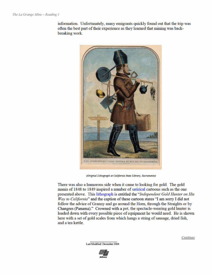
info1mation. Unfo1tunately, many emigrants quickly found out that the trip was often the best pa1t oftheir experience as they learned that mining was backbreaking work.
(Original Lithograph at California State library, Sacramento)
There was also a humorous side when it can1e to looking for gold. The gold mania of 1848 to 1849 inspired a number of satirical caitoons such as the one presented above. This lithograph is entitled the "Independent Gold Hunter on His Way to California" and the caption of these cartoon states "I am sorry I did not follow the advice ofGranny and go ai·ound the Hom, through the Straights or by Changres (Panama)." Crowned with a pot, the spectacle-wearing gold hunter is loaded down with eve1y possible piece of equipment he would need. He is shown here with a set of gold scales from which hangs a suing of sausage, dried fish, and a tea kettle.

The La Grange Mine - Reading I
Gold fever extended beyond the borders of the United States and gripped much of Europe, Asia, Canada, Mexico and South America. Dame Shirley, a noted author ofthe time writing from the California gold fields to her sister back east, noted that,
"You will hear in the same day the soft melody of the Spanish language, the piquant polish of the French . . . the silver, changing clearness of the Italian, the harsh gargle of the Geiman, the hissing precision of the English, [ and] the liquid sweetness of the Kanaka."
Another trend that grew out of the gold msh was the creation ofunique California stationery known as a letter sheet. The letter sheet consisted of a light-weight blue, gray, or white writing paper embellished with a woodcut or lithograph (printed picture). Letter sheets were produced primarily in the 1850s and because of the union ofpictures with statione1y many historians refer to these letter sheets as the foremnner of modemday postcards. Common subjects included mining camps and towns, cities, Inining scenes, natural wonders, and events such as fires. Most letter sheets were never used for their intended purpose - letter writing -since most were saved as mementos.
SIINDR1 ANUStllENTS IN THE MINES
(lithographed andPublishedby Quirot & Co., San Francisco)
Continue
Last Modified: December 2004

The La Grange Mine - Reading I
Questions for Reading 1
I . What are some of the various factors that contributed to the rapid spread of "gold fever" in the United States?
2. Using the glossaiy, look up the definition for the word "satirical." Why do you think that "Gold Mania" was satirized in newspapers and magazines of the day?
3. What is a "letter sheet?" Using the one provided on the previous page to describe what might be taking place in each scene.
Continue
LastModified: December 2004

The La Grange Mine - Reading 2
How to Use the Readings
Inquiry Question
Historical Context
Reading 1 Reading 3 Reading 4
Images
Activities
Table of Contents
Determining the Facts
Reading 2: Mining Technologies in California
(Original Lithograph "Gold Washing in the Sie"a Nevada")
The earliest methods of gold extraction were used on shallow, easily reached deposits and involved simple equipment. Mining equipment generally consisted ofa large, shallow, flat-bottomed tin pan for washing gold, a shovel, and a pick. Squatting by the side ofa river or a stream, the miner would fill his pan with what he hoped would be "pay dirt." He would then hold the pan under the surface of the water and swirl it about with a gently rotating motion for several minutes. With one side of the pan lower, the water would wash away the lighter dirt and sand, leaving behind the heavier gold particles - if there were any - in the bottom of the pan. Panning was a dull, backbreaking job. A bucket of"washed" dirt might yield 10 cents in gold. The miners needed to wash 160 buckets a day in order to make $16.00 - the average price ofan ounce ofgold.
Continue
Last Modified: December 2004

The La Grange Mine - Reading 2
During the early days of the gold msh, the miners working the placers could afford to be very choosy where they mined since there was so much gold. As one placer played out, the miners would simply move on to the next "diggins." However, by 1855 the placer deposits along California's streambeds had begun to give out, requiring a change in mining technology. One of these methods was "ground sluicing."
Aided by the use of shovels and picks, unpressurized water was used to break down stream and river tenace margins by the action of water flowing over them. The eroding forces of water and gravity allowed the miner to penetrate deeper into the river gravels, thus allowing for the recovery of less accessible placer gold. The gravels were then washed through an open wooden trough or sluice box, such as a "long tom," which would capture the gold.
(Miners Work the Long Tom, unknown artist, circa 1850s).
The use of ground sluicing spread rapidly and, according to an 1898 newspaper account on mining in Trinity County "Money was plentiful and times were good" between the years 1855 and 1860. Throughout the region, low-lying areas near sources ofwater were extensively mined during this period. The higher areas of ground above the streams and creeks could be worked as well, but water had to be brought in from lakes and streams high in the mountains. The construction of extensive water systems, which tapped into these water sources using a series of ditches, wooden flumes and metal pipes, known as penstocks, allowed these higher grounds to be worked. However, as time went on even these deposits of gold became used up. Rich deposits of the precious metal still remained fiu below the surface but in order to recover the gold, more complex and destructive methods were required.
Continue
Last Modified: December2004

The La Grange Mine - Reading 2
-- ..,
\ --.,_ • ~It. . ..
(Monitors in use at Horumac Hydraulic Mine, circa 1896. Previously published CG, V39, no. 8, p 181}
Perhaps the most dramatic ofthese new mining methods was "hydraulicking" which used a stTeam ofhigh-pressurized water to uncover the gold-bearing gravel that was located far beneath the surface. Hydraulic mining was a tJ.ue California invention. It was first inu-oduced to the Sierra Nevada gold fields in 1853, when a fo1mer sailmaker, Anthony Chabot, built a canvas hose, and Edward E. Matteson invented a tapered nozzle ofsheet brass. This device became known as a monitor or ' giant.' Water, aimed at the gold-bearing hillside, shot out of the monitor's nozzle with great force, dissolving the hill slope into a muddy flow that was caught with a long sluice box. The concept was simple: Matteson had merely copied nature, where over geologic time the watercourses would cut down through ancient gravel beds, digging out gravel containing gold and depositing that gold behind rocks and logs in the existing stJ.·eambed. For the next three decades, hydraulic mining was the dominant fo1m of gold extraction in northern California.
Continue
Last Modified: December 2004

The La Grange Mine - Reading 2
Mining companies spent millions of dollars developing hydraulic mines in California. By 1870, they had built numerous storage rese1voirs high in the mountains and thousands ofmiles of inter-linked ditches, tunnels, and flumes, all in order to supply the vast amounts of water necessary for hydraulicking. These projects were among the largest engineering ventures undertaken in California at the time, and they were carried out by private funds, without any mies or regulations imposed by the State.
Matteson's invention not only changed the mining industry in California, it also brought about one ofthe greatest environmental disasters of the 19th centmy. Great volumes of muddy water canying millions ofcubic yards of debris moved down through the sluices and drains and poured into the streams and rivers flowing out of the Sie1rn Nevada. Each winter this mass ofmaterial moved out of the mountain canyons to be deposited in the relatively flat streams and overflow basins of the Sacramento and San Joaquin valleys. These muddy waters resulted in widespread flooding and destruction ofagricultural land in the Sacran1ento Valley.
Valley farmers appealed to the comts for reliefand after over a decade ofdebate, the comis finally rnled in favor of the California agricultural interests. Known as the "Sawyer Decision of 1884," it prohibited miners from discharging tailings of any size into streams that were tributa1y to the Sacramento River unless there was proper debris control. Even with subsequent legislation such as the "Caminetti Act of 1893," which allowed limited mining by using debris dams, large-scale hydraulic mining never regained its former impo1tance in the Sierra Nevada.
Questions for Reading 2
1. Name three different methods of gold mining used in California~ and describe the equipment that is necessa1y for each method.
2. By examining the illustrations provided in this section, which of the three methods discussed above would require the greatest number ofpeople to cany out.
3. Which of the gold mining methods discussed in this reading resulted in the greatest effect to the environment. What were these effects and what was the result?
4. Identify an enviromnental concern that is cmTently in the news today and discuss the potential effects to the environment.
Continue
Last Modified: December 2004

The La Grange Mine - Reading 3
(Baron Ernest de La Grange)
Like his wife, Clementine, the Baron Ernest de La Grange belonged to the French nobility. But, the rituals ofFrench high society and the life they led began to strike them as "frivolous and useless." Ernest complained that managing the family castle, La Motte au Bois, did not keep him busy enough, and Clementine swore that she would follow him wherever he decided to go, even to the ends of the earth. At that time, repmts about the gold and diamond mines of the Transvaal filled the French newspapers and for a briefperiod, they thought seriously of going to Africa. Leaving behind a France that was in political, social and economic chaos, Baron Ernest de La Grange and his family decided in 1892 to come to the United States.
It appears that the Baron was much like one ofhis American counterpa1ts, Theodore Roosevelt, in his pursuit of the rngged outdoor life. The Baron, Clementine, and their two young children, Emilie and Amamy, left on the SS Rotterdam for a 17-day voyage across the Atlantic Ocean. Upon their atTival in New York, the Baron and his family began traveling throughout the western United States in search of a ranch or industrial property that would become the family home and business. Their travels eventually led them to Weaverville where they rented a small house from which to rnn their newly-acquired mine.
Continue
LastModified: December 2004

The La Grange Mine - Reading 3
(This photo was taken around 1895 oftheLa Grange Hydraulic Gold Mining Company's inverted s iphon acrossEast Weaver Creek. The Baron and Baroness deLa Grange are standing on the leftside ofthe pipeline. Photo onfile at Trinity County Historical Society) .
The Baron was not alone in his management role over the constmction and operation of the mine. The Baroness Clementine de La Grange was very much a "hands-on" partner in the day-to-day operations of the mine. It was not odd to find the Baroness on inspection tours of ditch-building sites or directly involved in the muddy business of cleaning the gold from the sluice boxes. Even many years after her death, the Baroness' own words describing her experiences in her memoirs clearly reveal her devotion to the mine.
October 16, 1893 For the last several days, I've gone on long mountain excursions to
inspect thejobfrom one end to the other. They've done excellent work. The ditch is fourteen and a halfmiles long and has been fortified on one side with a wide bank of dirt, whereas the other side is solidly supported by the mountain. Barring a horrendous avalanche, I believe it will withstand winter storms. The trail along the ditch is so narrow that our little horses need all their skill to stay on it. One false step would send steed and rider into the abyss. I admire the grace with
Continue
Last Modified: December2004

The La Grange Mine - Reading 3
Determining the Facts
Reading 3: The History of the La Grange Mine
How to Use the Readings
Inquiry Question
Historical Context
Reading 1 (Monitors in use at La Grange Mine, near Weaverville, California, circa 1940) Reading 2 Reading 4 The hydraulic mines of the Trinity River Basin escaped the ban against hydraulic
mining prescribed in the Sawyer decision. Unlike the mines in the Siena, the area was unsuitable for fa1ming and the debris from the Trinity mines was
Images dumped into rivers where it was canied out to the Pacific Ocean. Because of this, there was no legal basis to extend the ban by Congress into this mining region of the State. So, while large-scale hydraulic mining in the 1890s was near its end in the Siena Nevada, it was in its infancy in the Trinity River area. The major factor
Activities holding back the hydraulic mining industiy in this portion of the State during the 1890s was the lack of extensive ditch systems like those that served the centI·al Sienan mines.
Table of Contents fu order to overcome this difficulty, a group oflocal miners organized themselves
as the Weaverville Ditch and Hydraulic Mining Company in 1873. The company joined a number of claims and built a network ofditches that delivered enough water to make hydraulic mining possible in Oregon Gulch. fu 1879, this company was sold to the Trinity Gold Mining Company (TGMC) which was made up of some ofWeaverville's leading businessmen. The TGMC continued to wash the gold deposits from the western slope ofOregon Mountain until 1892, when Baron de La Grange purchased the mine for $250,000. The La Grange Hydraulic Gold Mining Company had its main office in Denver and was led by its group ofFrench and Colorado investors who owned and operated the mine between 1893 and 1905.
Continue
Last Modified: December2004

The La Grange Mine - Reading 3
which my chestnut mare changes feet to avoid a pile ofrubble that would bring her close to the edge ofthe cliff
November 14, 1893 I'm all-alone at the mine: Ernest and the engineers are in San
Francisco ... This morningfor the first time I took my gun and beat the bushes in the valley. I s ighted three hares within reasonable shooting range, but I was incredibly clumsy and killed only one. How popular I'll be when I come home with this game, which I'll call by a special name on the menu. It will be a real change f rom our usual f are of old beefand old mutton. I was really lucky, because you have to go some distance to find game: it is chased away by civilization, no matter how primitive ...
December 10, 189 3 I spent yesterday next to a monitor, admiring the beautiful imposing
spectacle ofthis hydraulic force of3,000 horsepower. As the stones are thrown f rom the ground, they form a frame around the shooting stream ofwater that makes a noise like thunder. The strong current pulverizes the base ofthe cliff with an enormous roar. The man holding the monitor can change its direction with a slight turn ofshoulder, reducing this mass of earth into liquid mud which then flows into the sluices like a torrent, filling the wooden interstices ofthese primitive strong-boxes with the p recious metal. I have the greatp leasure of climbing up and replacing the worker on the platfonn, while he shows me where to direct the spray.
February 1, 1894 .. .Ernest went to San Francisco on business and he's coming back
tonight: he 'll be dead tired after thirteen hours on the bumpy road from Redding to the mine. He 's bringingback Mr. Radford, an engineer with an excellent reputation who was the brains behind another successful operation: the North Bloomfield. It had to be closed on account ofthe debris law. This law put an end to many of the hydraulic mines in California because of the great damage to the localfarms. This damage is caused by the p ile up ofdebrisf rom the mining operations in the valleys below. Our mine, situated on the Pacific side in an area unsuitableforfarming, remains unaffected by this law since the water carries the debris to the Trinity River, whose torrential current takes it all the way to the sea. Nonetheless, in spite of all the efforts to the contrary, a little settlement at the bottom ofOregon Gulch runs the risk ofbeing buried when we run our operation full-scale. The church on the valley floor can be moved higher up the mountain, and the houses, made ofwood can be easily disassembled, and relocated around it.
Continue
Last Modified: December 2004

The La Grange Mine - Reading 3
June 12. 1894 A terrible thing happened to Jose, owner ofthe stagecoach that runs
between Redding and Weaverville. One ofthe poor man 's drivers was robbed of $200 by another stage driver on the road .... When carrying valuables on this long deserted road to Redding, one must carefully avoid letting anyone suspect it. I recen#y traveled with $5,000 worth ofclean-up, but I put it in an ordinary dishtowel from which I would take a crust ofbread or some cannedfood every so often. I thus made it seem as ifthis was myfood supply, and not even the stage driver guessed that I was, as the Americans say, "worth five thousand dollars."
June 21. 1894 Mr. Radford now has the mine well in hand. I'm sure he will make it
prosper, so we are thinking serious~y ofsetting sail for France. The children no longer dream ofanything but little French cousins, uncles, and aunts. But on waking, they 're upset at leaving their pigeons, their cats, and their chickens .... And as for us adults, we 're leaving behind memories oftrying days and happy days, leveled out in such a way that the latter erase the former, leaving us with a positive, comforting impression.
Questions for Reading 3
1. Why were the hydraulic mines in the Trinity River basin able to continue operating even after the Sawyers Decision?
2. Why do you think the Baron and his wife chose to leave France behind? Would you want to travel with two young children to a place like Weaverville to strike it rich? Why or why not?
3. Based on the Baroness' memoirs, do you think her life was unusual for women living during this time? Why or why not?
Reading 3 was complied from Julia G. Costello and Stephen R. Wee, The Oregon Mountain Summit and La Grange Mine Historic Properties (California Department of Transpo1tation Distiict 2, Redding, California, 2000), and Clementine De La Grange, From the Known to the Unknown - The Memoirs ofBaroness de La Grange - 1892 -1894 (Translated from the 01iginal French by Thomas Buckley, Ph.D. and Published by the Trinity County Historical Society, Weave1ville, California.)
Continue
Last Modified: December2004

The La Grange Mine - Reading 4
How to Use the Readings
Inquiry Question
Historical Context
Reading 1 Reading 2 Reading 3
Images
Activities
Table of Contents
Determining the Facts
Reading 4: Historical Archaeology at the La Grange Mine
(Miners and cabin atLa Grange Mine. Trinity County Historical Society Archives)
Whenever groups ofpeople abandon a "site" or place they once lived and worked, they leave behind items that they no longer need. These items may include material remains or "a1t ifacts" such as bits and pieces ofbuildings and machines they once used, or garbage dump where they tossed their household trash. Archaeology is the study of the past based on the remains that earlier people left behind or discarded. By carefully collecting and examining a1tifacts from a site, an archaeologist can help us understand how these people met the challenges oflife in the past. Historical Archaeologists study not only artifacts and sites, but also documents written about the people and places they are interested in. Photographs, diaries, mining records, newspaper stories, and company ledgers can also provide valuable information.
Historical archaeology may tell us a different stmy than the one that is written down. Very few documents tell us about the private lives of these people or the "average" worker and their daily life. By recovering and studying what people threw out, left behind, and lost, historical archaeologists can tell things like what the people ate, what their homes looked like, and what type of clothes they wore.
Continue
LastModified: December 2004

The La Grange Mine - Reading 4
The La Grange Mine had two separate areas where employees lived. The manager and the Baron's family lived in a residential area that was located on the northern edge of the mine on top of a hill above Coopers Gulch. From this area, they could overlook the La Grange mine pit and sluice boxes to the east and south. The original plan for the Baron's home was for a one-story office building. In early 1895, however, the plans were changed at the Baron's request to add a second story and a small kitchen addition at the rear of the building including a pantry, cook's room and a dining room. With its many windows and balconies, "The Castle," as it was known, offered the owners and their guests a view of the mine' s operations.
Baron La Grange died in 1899 in France apparently in a swimming accident. Following his death, the Castle became the residence ofPierre Bouery, the mine's manager. Under Bouery' s supervision, the La Grange was highly successful. According to historical sources, Boue1y remodeled the Castle and its grounds. He installed fireplaces with imp01ied tiles, sent to France for special wallpapers and used stained glass in the windows. The home also became famous for its wine cellars, gommet food, and dinner pa1iies.
The workers lived on the opposite side of the canyon from the managers, at the southern edge of the mine across Oregon Gulch. Between the years 1893 and 1911, a number ofbuildings were built by the company for their employees. The first building completed was a men's boardinghouse, followed by a company store which supplied all the items needed by the miners. By 1900, a lodging house, sometimes refened to as the La Grange Hotel, had been built along with various barns, stables and sheds, and two family cottages. The wagon road from Weave1ville to Junction City passed through the center of town. Trinity County created the La Grange School District in the spring of 1911, and the first schoolhouse at the mine was opened in the fall of that year with 13 pupils enrolled.
The only things that remain of this once bustling mining town are the scattered rnins where the buildings once stood. There are no standing structures and most of the larger pieces of equipment have either been moved to other mines, have been sold as scrap metal or have been illegally collected by souvenir hunters. Archaeologists working at the mine site found bits of glass, metal and wood, which mark where the buildings were. For example, the location of the Castle can be identified today by three flat tenaces that are lined by 50-foot-long rock walls. Scattered about these terraces, the archaeologists also found timber with nails and metal spikes, tarpaper fragments, iron sheet metal, glass bottle fragments and metal cans.
Continue
Last Modified: December 2004

The La Grange Mine - Reading 4
Other artifacts recorded by archaeologists near where the managers lived include household items, which were made between 1895 and 1918. Things such as broken cups and plates from England, various colored glass and bottle fragments, food and tobacco cans, baking pans, canning jar lids and a small leather glove, give archaeologists clues about when people lived here. Questions such as; did they rely mainly on wild game and fish for their daily diet or did they eat purchased and canned foods from town, can be answered as well. The items examined by archaeologists can also tell us ifwomen and children once lived here, like the Baroness and her children. Or, if there is any proof that the people that lived in the Castle kept a link with Europe while living on the California frontier. By using both historical and archaeological skills to study the evidence, we can begin to complete a picture of life at the La Grange Mine for the owners and managers as well as the average worker and his family. In this way, archaeologists can provide details about these peoples' lives which are not available anywhere else.
Questions for Reading 4
1. Examine the photo at the beginning of this section and list some of the amenities that you are surprised to find in this scene.
2. Make a list describing what archaeological evidence has been discovered at the La Grange Mine. How have these a1tifacts helped archaeologists inte1pret what took place there?
3. What things might you expect to find in the garbage dump if the Baroness and her children were living at the site? Would you expect to find items from France or Europe? Why or why not?
4. What differences, ifany, might you expect to find in the a1tifacts left behind by the workers and their families from those found where the manager's lived? Where would you expect to find the greater number ofdecorative or fancy items versus utilitarian items?
5. How has archaeology been important in studying the La Grange Mine?
Reading 4 was complied from Julia G. Costello and Stephen R. Wee, TI1e Oregon Motmtain Summit and La Grange Mine Historic Properties (California Department ofTransportation District 2, Redding. California, 2000) .
Continue
LastModified: December 2004

The La Grange Mine - Visual
Visual Evidence
Photo 1: Hydraulic Monitors in Operation at the How to Use La Grange Mine Pit the Images
Inquiry Question
Historical Context
Readings
Map3 Photo 2 Photo 3
Activities
Table of Contents
(Trinity CoimtyHistorical Society Archives)
Questions for Photo 1
1. Based on what you learned in Reading 2, how did the monitors operate?
2. What changes in the environment would take place with the use of this equipment?
Continue
Last Modified: December2004

The La Grange Mine - Visual
How to Use the Images
Inquiry Question
Historical Context
Readings
Photo 1 Photo 2 Photo 3
Activities
Table of Contents
Visual Evidence
Map 3: Overall map of La Grange Hydraulic Mine Complex
CountyWagonRoad,.... - - .,; From Weaverville to Junction City Edge ofHydraulic Pit
Ditch. Siohon and Reservoir Svstern =---- Housin2 Areas
,-(_,1
D Map 1 shows the La Grange Hydraulic Mining complex and the topography of the site. The closer the topographic lines are to one another, the steeper the tenain. The map also shows the location of the ditch, siphon, and reservoir system that supplied the mine with water.
Questions for Drawing 1 1. Looking at the topographic lines, why do you think the water systems are
located where they are?
2. What is the advantage ofplacing the mining pits downhill from the water system?
3. Describe the mining process at the La Grange Hydraulic Mine. Does this map help you understand better how the process worked? Why or why not?
Continue
Last Modified: December2004

The La Grange Mine - Visual
How to Use the Images
Inquiry Question
Historical Context
Readings
Photo 1 Map3
Photo 3
Activities
Table of Contents
Visual Evidence
Photo 2: View of La Grange Manager's Residential Area
(Archaeologists are taking measurements ofthe rock-linedterrace that was oncepart ofthe Castle. Photo onfile at California DepartmentofTransportation, North Region, Redding, California)
These are the remains of the Castle at the La Grange Mine. Julia Costello, a historical archaeologist, appears in the photo along with her assistant. The original plans for the Castle called for a one-story building. But in 1895, the plans were changed at the Baron's request to add a second story and a small kitchen addition at the rear of the building to include a pantly, cook' s room, and dining room for the Baron' s use when he visited the mine. This photo shows one of three rock-lined te1rnces which remain of the original strncture. The rock te1rnces fo1med the foundation which the house was built upon, much like our use ofconcrete today.
Continue
Last Modified: December 2004
The La Grange Mine - Visual
Visual Evidence
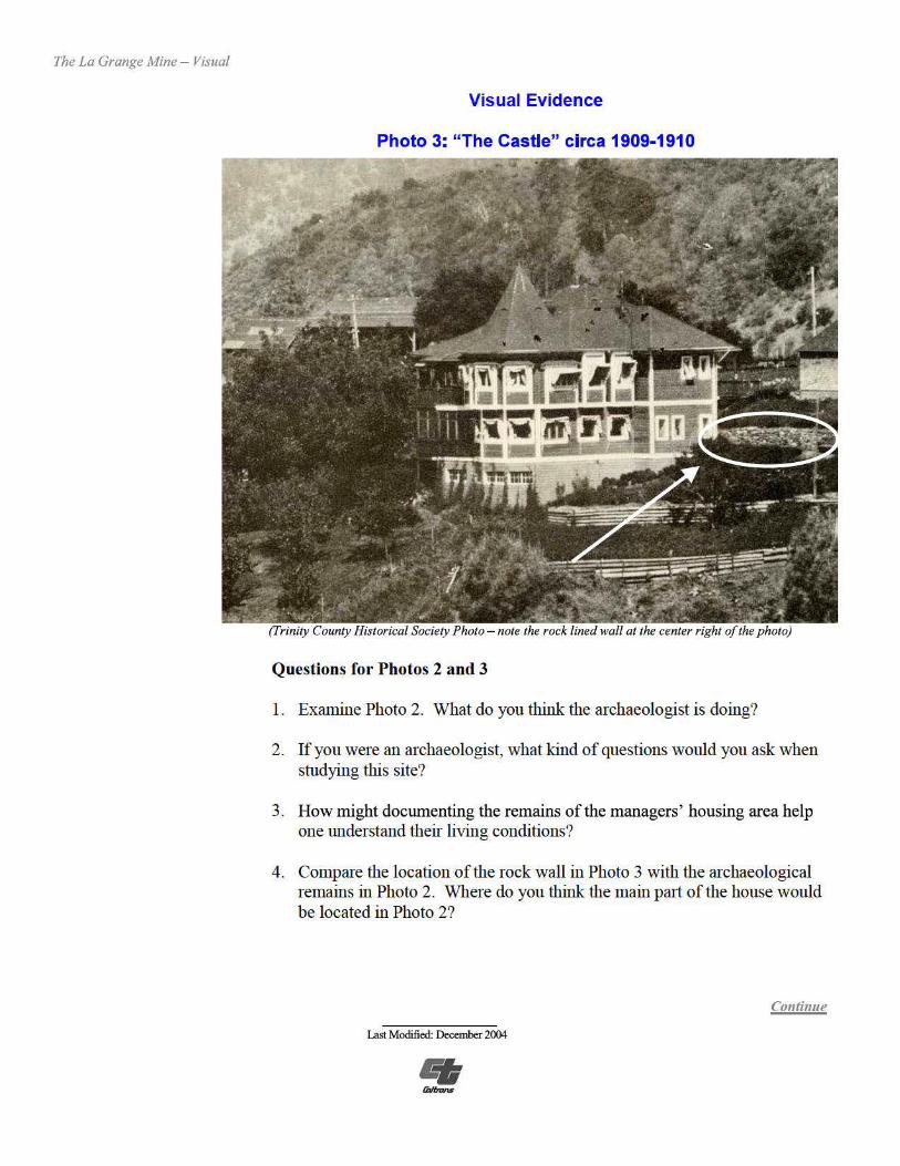
Photo 3: "The Castle" circa 1909-1910
(I'rinity County Historical SocietyPhoto - note the rock lined wall at the center r ight ofthephoto)
Questions for Photos 2 and 3
1. Examine Photo 2. What do you think the archaeologist is doing?
2. Ifyou were an archaeologist, what kind of questions would you ask when studying this site?
3. How might documenting the remains of the managers' housing area help one understand their living conditions?
4. Compare the location ofthe rock wall in Photo 3 with the archaeological remains in Photo 2. Where do you think the main paii of the house would be located in Photo 2?
Continue
Last Modified: December 2004

The La Grange Mine - PuttingIt All Together
How to Use the Activities
Inquiry Question
Historical Context
Readings
Images
Table of Contents
Putting It All Together
fu this lesson, students explore both how gold was mined in the late nineteenth and early twentieth centuries and how historical archaeologists piece the past together from a1tifacts and documentary evidence. The following activities will help them apply what they have learned.
Activity 1: California Before the Rush Have the students research what life was like in their community before the Gold Rush of 1849. Who was living in the area and what was their life like during this time? What impacts did the Gold Rush have on their life? An alternative activity would be to have students conduct an oral history on the life ofa specific person who lived in their area during the early pa1t of the twentieth century. What was their life like back then? Where did they live and work? What were the important local events that were happening back then? Have students make a class presentation on their findings.
Activity 2: "Come One, Come All, to the Great Land of Opportunity" Have students write newspaper a1ticles on the historical mining discoveries in California. For example, announce the Sutter's Mill find of 1848 or P.B. Reading's find at Clear Creek in Shasta County. Posters, or television or radio adve1tisements could also be created instead ofnewspaper a1ticles. Students could work in teams to put their adve1t isements on video and share with the class.
Activity 3: Journey to the Land Of Gold Working in small groups, have students look thrnugh old newspapers and files in their local libra1y or historical society archives to determine from what areas of the world or United States the early miners originated. Research world events that were taking place at this period of time, such as in China or Europe, and discuss in class the possible reasons that led to these individuals' decision for migrating to an unknown land. Compare the reasons that led people to migrate to the U.S. then, with now.
Activity 4: The Archaeological Record Have each student choose one or several objects from home or school that they think will be crncial for future archaeologists to understand our society. Have the student make a class presentation explaining why they chose what they did and what possible meanings might archaeologists of the future attribute to their artifact. Have the other students discuss if they think it will be obvious what the objects were used for, or will the archaeologists have trouble detennining their use? What ifonly part ofan object was found, rather than the whole item? Bring some fragments that you have chosen to class and discuss what they might be and mean.
Continue
Last Modified: December2004

The La Grange Mine - Supplementary Resources
The La Grange Mine: Changing the Landscape in the Quest for Gold
Supplementary Resources
Inquiry The LaGrange Mine: Changing the Landscape in the Quest for Gold will help Question students understand some of the methods that were used to mine gold in the 19th
and 20th centuries and what impacts these methods have on the environment and people living in the region. The lesson plan provides insight into how
Historical archaeologists are able to piece together the past from artifacts, archaeological Context evidence and archival infonnation. Those interested in learning more will find
that the Internet offers a variety ofmaterials.
National Park Service Archaeology and Ethnography Program The National Park Se1vice (NPS) is a steward ofour diverse cultural legacy. From the cliff dwellings of the Southwest to the reminiscences of neighborhood residents where Ma1tin Luther King, Jr. grew up, this legacy represents a continuum of
Readings American heritage-its places, objects and traditions. The NPS Archaeology and Ethnography Program provides national leadership, coordination, and technical guidance to aid in preserving this heritage. For the public
Images www.cr.nps.gov/archeology.htm offers in-depth features on archaeological projects, infonnation on how to learn and pa1ticipate in archaeology, and a variety of teacher resources.
Table of Gold Rush Contents Th site listed below was created by the Sacramento Bee newspaper and has
detailed easily accessible infonnation on all three-travel routes that were used by early miners heading for the gold fields ofCalifornia. The site, www.calgoldrnsh.com, includes cost, travel time, food, problems, weather infmmation on these early routes. You can also find information on the daily life ofminers, the impact of the Gold Rush in the West, and hardships suffered by mmers.
Alvin A. Coffey This account ofAlvin A. Coffey's journey to the California gold fields overland by wagon is filled with descriptions ofvarious adventures he expe1ienced along the way. The site www.sfmuseum.org.bio.coffey.html also contains a wealth of first hand accounts regarding the California Gold Rush and life in California before the discove1y of gold.
Continue
Last Modified: December 2004

The La Grange Mine - Supplementary Resources
Jake Jackson Museum and History Center Located at 508 Main Street in Weave1ville, California, the Jake Jackson Museum and History Center contains an extensive collection of aitifacts, histo1ic documents, records, photographs, maps and books that cover all facets of the hist01y ofTrinity Comity and smrnunding at'eas. The resources available and their hours of operation can be found on their website at www. tcoekl 2org/~museum/index.htm.
The California Gold Country - Highway 49 Revisited This site allows you to browse the online version of this publication and take a viitual tour where you can visit old mining sites, learn then· histo1y, and view images produced during the California Gold Rush. This site, www.malakoff.com/goldcounty/maintcgc.htm, provides an excellent link to additional Internet resources which contain information on California's Gold Rush historic past.
California State Library - Gold Rush Exhibit The exhibit at this site (www.library.ca.gov/goldrnsh/images/html) features over 100 examples from the California History Section's extensive manuscript collection pe1taining to this period. Several topics ai·e included in this vi1tual exhibit ranging from "Scenes in the Life ofthe California Miner," "The Miner' s Ten Commandments," "The Northern Mines," and the "Overland Trek."
Oakland Museum of California The Gold Rush! Online cmTiculum, Myth & Reality: The California Gold Rush and Its Legacy at www.museumca.org/goldrnsh/htm provides materials for grades 4, 5, 8 and 11 that provide students and teachers an oppo1tunity for historical inqui1y through prima1y source visuals and documents.
Huell Bowser's California Gold Series Huell Howser Productions, in conjunction with public television, is the host of a series called "California Gold." Many of the episodes in this series visit hist01i c gold mining sites around the State. Information on when the various episodes can be seen in your area can be found at www.calgold.com.
Society for Historical Archaeology The Society for Historical Archaeology (SHA) is the largest scholarly group concerned with the archaeology of the modem world (AD 1400-present). The focus of the society is the era since the beginning of European exploration. Included at www.sha.org.htm are a vai,iety ofonline publication links and research tools.
Continue
LastModified: December 2004

The La Grange Mine - Supplementary Resources
Society for California Archaeology The Society for California Archaeology (SCA) is a nonprofit scientific and educational organization dedicated to research, understanding, and conservation of California's archaeological resources. Included at www.scanet.org.htm is an education section that provides links to many other useful websites.
Mineral Information Institute The Mineral Inf01mation Institute (Mil) is a nonprofit organization dedicated to educating youth about the science ofminerals and other natural resources, and about their impo1iance in our everyday lives. The MII website at www.mii.org produces educational materials, which are provided at no cost to teachers in order to supplement existing cunicula. Search this website for more info1mation on gold such as its history, its prope1iies as a metal, how it is used, and its mining and processing.
For Further Reading Students and educators wishing to learn more about the mining industty and the California Gold Rush may want to read:
James Rawls and John Holder, Dame Shirley and the Gold Rush (Raintree Publishing, 1992)
Silver and Gold: Cased Images ofthe California Gold Rush (Drew Heath Johnson and Marcia Eymann, eds, Iowa City, IA: University oflowa Press for the Oakland Museum ofCalifornia, 1998)
Clementine de La Grange, From the Known to the Unknown, 171e Memoirs of Baroness de La Grange - 1892-1894 (Trinity County Historical Society, Weaverville, California).
Continue
Last Modified: December2004

Ho1r to Use this Lesson Plan
How to Use this Lesson Plan
Teaching with this lesson plan provides the opportunity to enhance student learning by bringing historic places directly to your classroom. Students can experience the excitement of these unique places and the stories they have to tell through carefully selected written and visual materials.
This lesson plan contains teacher materials and teaching activities. Teacher materials include the following sections: Introduction, Where it fits into the curriculum, Objectives for students, and Materials for students. Teaching activities consist of the following sections: Getting Started (inqui1y question), Setting the Stage (historical background), Locating the Site (maps), Determining the Facts (reading, documents, cha1ts), Visual Evidence (photographs and other graphic docun1ents), and Putting It All Together (activities). The lesson plan format was designed to allow flexibility but works best if the material in the plan is presented to the students as described below:
1. Getting Started Begin the lesson by asking students to discuss possible answers to the inquiry question that accompanies the Getting Started image. To facilitate the classroom discussion, you may want to print this page and use it to make an overhead transparency. The purpose of the exercise is to engage students' interest in the lesson's topic by raising questions that can be answered as they complete the lesson.
It should be pointed out to the students that rather than serving merely as illustrations for the text, images are documents that play an integral role in helping them achieve the lesson's objectives. To assist students in learning how to "read" visual materials, you may want to begin this section by having them complete the Photo Analysis Worksheet for one or more of the photos in the lesson plan. The worksheet is appropriate for analyzing both historical and modem photographs and will help students develop a valuable skill.
2. Setting the Stage Next, present the info1mation in Setting the Stage. This material may be read aloud to the students, summarized or photocopied for students to read individually or in small groups. Setting the Stage material provides background info1mation necessary to acquaint students with the topic of the lesson they will be studying.
3. Locating the Site Next provide students with copies of the maps and questions included in Locating the Site. Have students work individually or in small groups to complete the questions. Extended captions may be included to provide students with information necessary to answer the questions.
Back to the Beginning
Last Modified: December2004

Ho1r to Use this Lesson Plan
4. Determining the Facts Then provide students with copies of the readings included in Determining the Facts. Again, allow students to work individually or in small groups. The series of questions that accompanies each of these sections is designed to ensure that students have gathered the appropriate facts from the material.
5. Visual Evidence Next, distribute the lesson's visual materials among students. You can print these images and make copies ofthem or display them on a computer screen. Have the students examine the photographs and answer the related questions. Note that in some ofthe lessons two or more images are studied together in order to complete the questions. Extended captions may be included to provide students with imp01tant information.
Rather than serving merely as illustrations for the text, the images are documents that play an integral role in helping students achieve the lesson's objectives. To assist students in learning how to "read" visual materials, you may want to begin this section by having them complete the Photo Analysis Worksheet for one or more of the photos. The worksheet is appropriate for analyzing both historical and modern photographs and will help students develop a valuable skill.
6. Putting It All Together After students have completed the questions that accompany the maps, readings, and visuals, they should be directed to complete one or more of the activities presented in Putting It All Together. These activities engage students in a variety of creative exercises that help them synthesize the information they have learned and formulate conclusions. At least one activity in the lesson plan leads students to look for places in their community that relate to the topic of the lesson. In this way, students learn to make connections between their community and the broader themes ofAmerican hist01y they encounter in their studies.
Back to the Beginning
Last Modified: December2004

The La Grange Mine -Supplementary Resources
Photo Analysis Worksheet
Step 1:
Examine the photograph for 10 seconds. How would you describe the photograph?
Step 2:
Divide the photograph into quadrants and study each section individually. What details - such as people, objects, and activities - do you notice?
Step 3:
What other information - such as time-period, location, season, reason photo was taken - can you gather from the photo?
Step 4:
How would you revise your first description of the photo using the inforn1ation noted in Steps 2 and 3?
Step 5:
What questions do you have about the photograph? How might you find answers to these questions?
Back to the Beginning
Last Modified: December2004

The La Grange Mine -Supplementary Resources
Glossary of Mining and Archaeology Terms
Archaeology - The study of the past cultures through the recovery and analysis of their material remains.
Archaeological site - Any place where material evidence exists about the human past.
Artifact-Any movable object that has been used, modified or manufactured by humans.
Emigrant -A person who leaves one place to settle in another.
Diggins - Applicable to all mineral deposits and mining camps, but as used in the United States is usually applied to placer mining locations.
Flume -An open trough or channel, made of wood or other material, used to transport water from a distance to be used for power, transportation, etc; typically used in areas where a ditch would be impossible - like a cliffside or rocky hillside.
Giant- The nozzle of a pipe used to carry water for hydraulic mining; used to distribute and increase the force of water.
Ground sluicing - The use of free-flowing water to break down gravel in a placer deposit and wash it through a sluice. It was the first placer mining method in which the miner put water to use as an excavating agent. A stream of water was brought to the upper side of a bank of gold-bearing gravel and then led across the deposit through one or more channels. Starting at the lower end and proceeding upstream, the channels are deepened by picking the bottom while the water carries the loose material away. The water moves the loosened material through a natural sluice (ground sluice) prepared on bedrock, or through a conventional sluice box placed at the lower end of the workings. As the lighter material is washed away, the coarser gold collects in bedrock crevices or behind rocks laying on the bottom of the ground sluice or riffles in sluice box.
Historical archaeologist - An archaeologist who specializes in the study of the material remains of past societies that also left behind some written record .
Hydraulic mining -A method of mining by which a bank of gold-bearing earth or gravel is washed away by a powerful jet of water and carried into sluices, where the gold separates from the earth by its density.
Hydraulicking - The act of hydraulic mining.
Kanaka - Native Hawaiian people who come over to mine.
Landform - A feature of the earth attributable to natural causes. Back to the Beginning
Last Modified: December 2004

The La Grange Mine -Supplementary Resources
Lithograph - A print made by the process of lithography where the image to be printed is receptive to ink and the blank area or paper is ink-repellant.
Lode gold - Gold found in veins within quartz or other rock.
Long tom - A rectangular box that measures about 12 to 15 feet long and 2 feet wide. Mainly made out of wood, the box had a metal bottom with a sieve and a ripple box at its end. The box was put with a slight slope to aid the flow of water. Gold-bearing earth or gravel was crudely washed in the box, a type of sluice box but longer and more narrow.
Memoirs - a written account of one's life based on personal experiences.
Monitor - Used in hydraulic mining, a device consisting of a nozzle and holder. It resembles a firehose-type nozzle that sprayed huge amounts of water on hillsides to recover gold out of them; used to project high-pressure water on gravels and sands to break down, wash and transport them.
Mother Lode - Refers to the vast area of Central California where gold was found in large quantities. It was called the Mother Lode because the whole area was a source, not just a small target area.
Panning - The process of washing gold-bearing gravel in a shallow metal pan to obtain the gold it contains. The pan is partially fil led with dirt and held under water. A gentle shaking aids in dissolving the dirt and thin mud is formed. The mud is carried away by running water and the gold settles to the bottom of the pan where it can be removed.
Pay dirt- Soils that contain gold.
Penstock - A rivetted metal pipe that is used to transport water for mining purposes.
Placer gold - Gold particles that have become separated from their parent rock and are found concentrated in the sands and gravels of streams and river beds.
Placer mining - Method of mining where gold is obtained by washing alluvial sands or gravel.
Reservoir - An artificially built, dammed, or excavated place for holding a body of water.
River bar - A flat, sandy or gravelly area along a river that is exposed at low water.
Satirical - Relating to satire; a literary work holding up human vices and follies to ridicule or scorn.
Site -A location of an important event, occupation or activity, or a building or structure, whether standing, ruined or vanished; a concentration of material remains associated with past humans.
Back to the Beginning
Last Modified: December2004

The La Grange Mine -Supplementary Resources
Sluice box - A long, narrow, wood or metal artificial channel that water passes through when put in a creek or stream. Used to separate the dirt and rock material away from the gold. Gold, the densest metal known to humans, stays in the sluice box because of its heavier weight.
Tail race -The channel for conducting tailings or refuse away in water.
Tailings -Whatever is left behind from mining activity. The sand, gravel and cobbles which pass through the sluices in hydraulic mining; leavings; remainder; dregs; waste rock.
Topography- The graphic detail used on maps for a place or region to show natural or manmade features.
Back to the Beginning
Last Modified: December 2004