la geografía de españa - heinekeclassroom.weebly.com · al noroeste españa limita (borders) con...
TRANSCRIPT
LA GEOGRAFÍA DE ESPAÑA
• This fi le includes a reading in Spanish about Spain’s geography, 10
comprehension questions in Engl ish with a corresponding answer key,
and an activ ity for students to create a geographical map of al l the
key places and structures found within the reading.
• I use these activities with my bul lf ighting unit ; however, you could use
this activity before reading Carrie Toth’s La Hija del Sastre or on its
own.
• These activities meet the fol lowing ACTFL Standards: o Standard 1 .2: Students understand and interpret written and
spoken language on a variety of topics. o Standard 3. 1 : Students reinforce and further their knowledge of
other discipl ines through the foreign language.
• Need an editable copy? Simply emai l me at eldentl inger@gmail .com so
that I can send one to you! J • Find an error? Please email me immediately at eldentl inger@gmail .com so
that I can correct it!
Copyright © 2014 Elizabeth Dentlinger
o about.me/eldentl inger
The format for this document was modeled
after Martina Bex’s Reading Activity: La
Geografía de Guatemala. You can also read more
about her at http://martinabex.com/
Want to know where the images I used came
from? Click on the image to visit the original source.
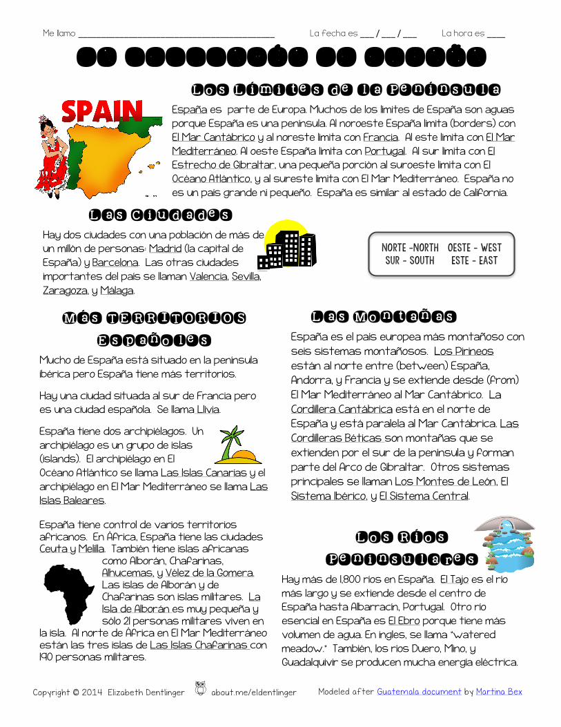
Más TERRITORIOS
Españoles Mucho de España está situado en la península ibérica pero España tiene más territorios.
Hay una ciudad situada al sur de Francia pero es una ciudad española. Se llama Llívia.
España tiene dos archipiélagos. Un archipiélago es un grupo de islas (islands). El archipiélago en El Océano Atlántico se llama Las Islas Canarias y el archipiélago en El Mar Mediterráneo se llama Las Islas Baleares.
España tiene control de varios territorios africanos. En África, España tiene las ciudades Ceuta y Melilla. También tiene islas africanas
como Alborán, Chafarinas, Alhucemas, y Vélez de la Gomera. Las islas de Alborán y de Chafarinas son islas militares. La Isla de Alborán es muy pequeña y sólo 21 personas militares viven en
la isla. Al norte de África en El Mar Mediterráneo están las tres islas de Las Islas Chafarinas con 190 personas militares.
Me llamo ___________________________________________ La fecha es ___ / ___ / ___ La hora es ____
LA GEOGRAFÍA DE ESPAÑA
Copyright © 2014 Elizabeth Dentlinger o about.me/eldentlinger Modeled after Guatemala document by Martina Bex
Los Límites de la Península España es parte de Europa. Muchos de los límites de España son aguas porque España es una península. Al noroeste España limita (borders) con El Mar Cantábrico y al noreste limita con Francia. Al este limita con El Mar Mediterráneo. Al oeste España limita con Portugal. Al sur limita con El Estrecho de Gibraltar, una pequeña porción al suroeste limita con El Océano Atlántico, y al sureste limita con El Mar Mediterráneo. España no es un país grande ni pequeño. España es similar al estado de California.
Las Ciudades Hay dos ciudades con una población de más de un millón de personas: Madrid (la capital de España) y Barcelona. Las otras ciudades importantes del país se llaman Valencia, Sevilla, Zaragoza, y Málaga.
Los Ríos
Peninsulares Hay más de 1,800 ríos en España. El Tajo es el río más largo y se extiende desde el centro de España hasta Albarracín, Portugal. Otro río esencial en España es El Ebro porque tiene más volumen de agua. En ingles, se llama “watered meadow.” También, los ríos Duero, Mino, y Guadalquivir se producen mucha energía eléctrica.
Las Montañas España es el país europea más montañoso con seis sistemas montañosos. Los Pirineos están al norte entre (between) España, Andorra, y Francia y se extiende desde (from) El Mar Mediterráneo al Mar Cantábrico. La Cordillera Cantábrica está en el norte de España y está paralela al Mar Cantábrica. Las Cordilleras Béticas son montañas que se extienden por el sur de la península y forman parte del Arco de Gibraltar. Otros sistemas principales se llaman Los Montes de León, El Sistema Ibérico, y El Sistema Central.
Norte –north Oeste – west Sur – South Este – east
Me llamo ______________________________________________ La fecha es ___ / ___ / ___ La hora es ____
LA GEOGRAFIA DE ESPAÑA
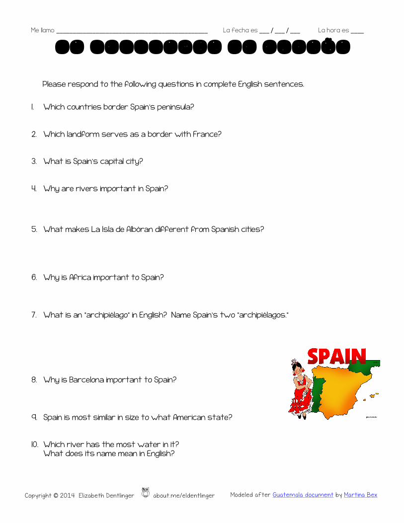
Please respond to the following questions in complete English sentences.
1. Which countries border Spain’s peninsula?
2. Which landform serves as a border with France?
3. What is Spain’s capital city?
4. Why are rivers important in Spain?
5. What makes La Isla de Albóran different from Spanish cities?
6. Why is Africa important to Spain?
7. What is an “archipiélago” in English? Name Spain’s two “archipiélagos.”
8. Why is Barcelona important to Spain?
9. Spain is most similar in size to what American state?
10. Which river has the most water in it? What does its name mean in English?
Copyright © 2014 Elizabeth Dentlinger o about.me/eldentlinger Modeled after Guatemala document by Martina Bex
Me llamo ______ANSWER KEY__________________________ La fecha es ___ / ___ / ___ La hora es ____
LA GEOGRAFIA DE ESPAÑA
Please respond to the following questions in complete English sentences.
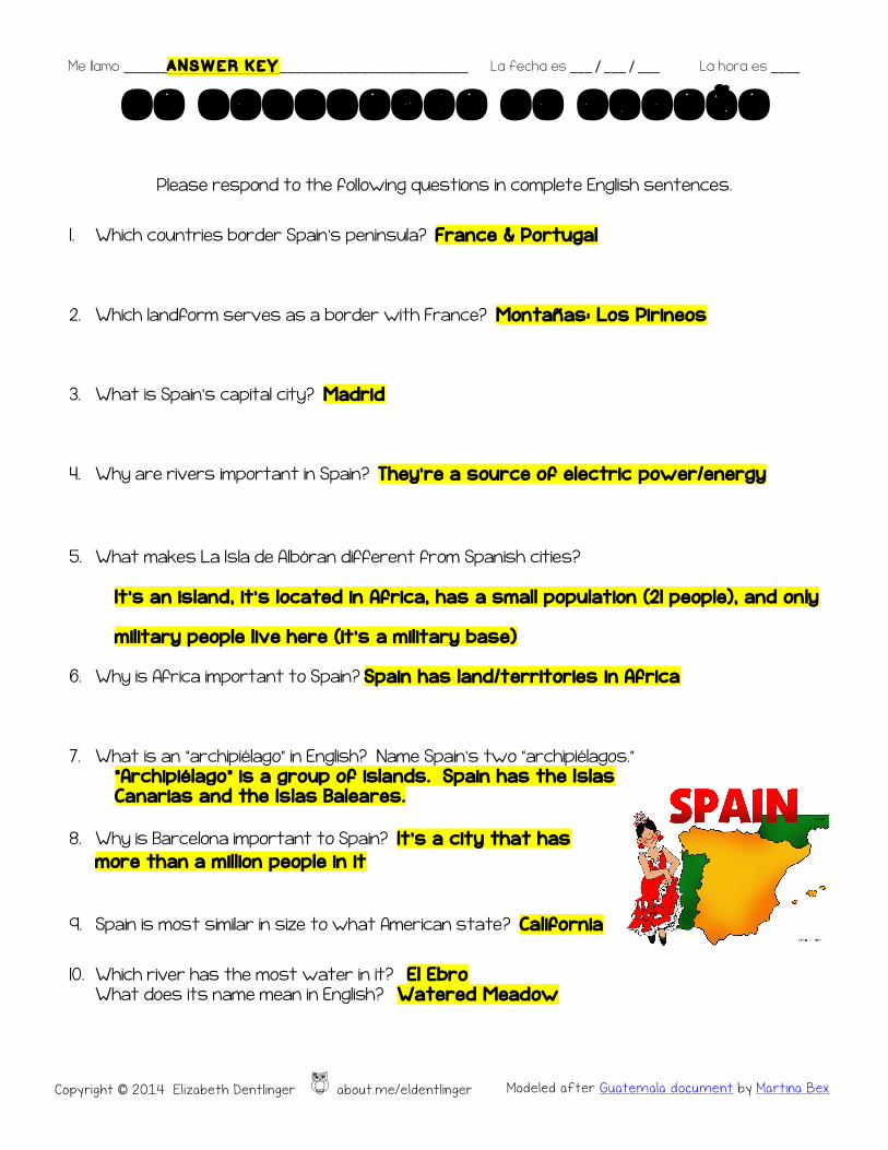
1. Which countries border Spain’s peninsula? France & Portugal
2. Which landform serves as a border with France? Montañas: Los Pir ineos
3. What is Spain’s capital city? Madrid
4. Why are rivers important in Spain? They’re a source of electric power/energy
5. What makes La Isla de Albóran different from Spanish cities?
It ’s an is land, it’s located in Africa, has a smal l populat ion (2 1 people) , and on ly
mi l itary people l ive here ( it ’s a mi l itary base)
6. Why is Africa important to Spain? Spain has land/territories in Africa
7. What is an “archipiélago” in English? Name Spain’s two “archipiélagos.” “Archip ié lago” is a group of islands. Spain has the Islas Canarias and the Is las Baleares.
8. Why is Barcelona important to Spain? It ’s a c ity that has
more than a mi l l ion people in it
9. Spain is most similar in size to what American state? Ca l ifornia
10. Which river has the most water in it? E l Ebro What does its name mean in English? Watered Meadow
Copyright © 2014 Elizabeth Dentlinger o about.me/eldentlinger Modeled after Guatemala document by Martina Bex

Me llamo ____________________________________ La fecha es ___ / ___ / ___ La hora es ____
ESPAÑA
Use the reading, the Internet, and other sources to mark a l l the underl ined geographical
features of Spa in from the reading on this map.
Source: http://d-maps.com/carte.php?num_car=2208&lang=en
norte
sur
este oeste
Copyright © 2014 Elizabeth Dentlinger o about.me/eldentlinger Modeled after Guatemala document by Martina Bex

Me llamo ____________________________________ La fecha es ___ / ___ / ___ La hora es ____
ESPAÑA
Use the reading, the Internet, and other sources to mark a l l the underl ined geographical
features of Spa in from the reading on this map.
Source: http://d-maps.com/carte.php?num_car=2209&lang=en
norte
sur
este oeste
Copyright © 2014 Elizabeth Dentlinger o about.me/eldentlinger Modeled after Guatemala document by Martina Bex