l b r assessment 10,996
TRANSCRIPT
DIAMOND DRILLING REPORT
T o r c h y 2 G r o u p Mineral C l a i m s , N a n a i m o
R i v e r A r e a , V a n c o u v e r Island
4 9 ' 0 7 ' N , 124' 05"W
NTS 92F/lW, 2 E
(Specogna C o p p e r , WO1, W02, & W04 Mineral C l a i m s )
for
CANAMIN RESOURCES LIMITED
i n the
NANAIMO MINING D I V I S I O N
B R I T I S H COLUMBIA
CANADA
J a m e s J. M c D o u g a l l , P . E n g .
E f r a m Specogna
982 WIpf7Xd8c; ~ C A L B R A N c H A S S E S S M E N T R E P O R T
10,996
TABLE O F CONTENTS
INTRODUCTION .......................... SUMMARY ............................... LOCATION .............................. ACCESS ................................ TOPOGRAPHY ............................ CLIMATE ............................... CLAIMS HELD BY COMPANY ................ HISTORY ............................... GEOLOGY ............................... DETAILED GEOLOGY AND MINERALOGY ....... SAMPLE PREPARATION AND ASSAY .......... D R I L L CORE STORAGE .................... D R I L L RESULTS ......................... CONCLUSIONS .......................... STATEMENT OF COST$ ..................... REFERENCE ............................. STATEMENT OF QUALIFICATIONS ...........
LIST OF FIGURES
F i g u r e 1 / 8 2 L o c a t i o n and C l a i m Map .......................
F i g u r e 2 / 8 2 Geological S k e t c h Map ...... F i g u r e 3 / 8 2 R o c k S a m p l e I n v e s t i g a t i o n .. Figure 4 / 8 2 C r o s s Sec t ion A-A' along
D D H ' s 3 . 4h82 .............. D r i l l Logs . Holes 1.2.3. & 4/82. and assay sheet ...
PAGE 2
2
3
3
4 4 4 5 6 7 14 14 15 15
1 7
1 8
1 9
1
9
10
1 6
"a t back of repor t"
- 2-
INTRODUCTION
The fo l lowing d r i l l i n g r e p o r t w a s prepared
a t t h e r e q u e s t of M r . Efram Specogna, P r e s i d e n t of
Canamin Resources Limited, t o h e l p f u l l f i l l assessment
requirements on the Specogna Copper ( 4 7 u n i t Group)
Mineral C l a i m s .
The r e p o r t i s based on work c a r r i e d o u t by t h e
w r i t e r , a s s i s t e d by Efram Specogna, fo l lowing a v i s i t
to t h e p rope r ty on December 1 4 , 1982 a t which t i m e a
diamond d r i l l i n g programme w a s suspended. The work
inc luded core logging, sample p r e p a r a t i o n and r e p o r t
p r e p a r a t i o n . During ear l ier v i s i t s t h e wr i t e r c o l l e c t e d
rock specimens f o r which l a b o r a t o r y r e p o r t s a r e enclosed.
Together w i th a g e o l o g i c a l ske t ch m a p , t h e s e supplement
a geochemical r e p o r t prepared by W. S . Read which w a s
submit ted as p a r t of an assessment report i n December,
1981. Except f o r a d d i t i o n s on Local Geology, t h e Read
r e p o r t i s used l i b e r a l l y f o r a more i n c l u s i v e backsround
t o t h i s D r i l l i n g Report .
SUMMARY
The Specogna Copper p rospec t , l o c a t e d about 40
k i lome t re s w e s t of Nanaimo, w a s t e s t e d w i t h a l i g h t
diamond d r i l l l a t e i n t h e 1 9 9 2 season when f o u r s h o r t
ho le s were completed from very l i m i t e d se t -up l o c a t i o n s
i n extremely p r e c i p i t u o u s t e r r a i n . Core recovery was
r e l a t i v e l y good and a b e t t e r a p p r e c i a t i o n of t h e
m i n e r a l i z a t i o n w a s obtained.
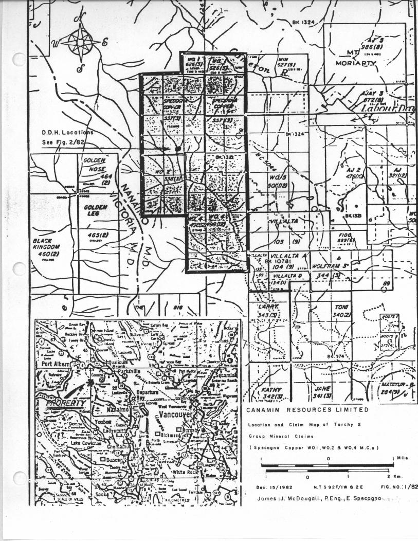
LOCATION
The Specogna Copper p rospec t i s l o c a t e d a t an
e levat ion of about 1190 metres about 8 . 5 km nor thwes t
of t h e n o r t h e a s t end of Fourth Lake, about 3 km. w e s t
southwest from Labour Day Lake, and abou t 0 . 6 km. n o r t h
of t h e upper reaches of t h e Nanaimo River. I n a s t r a i g h t
l i n e t h i s i s about 40 km. w e s t of Nanaimo on Vancouver
I s l a n d , B. C.
The co-ord ina tes of t h e copper showing are a t
abou t 49O07' N , 124O30 .3 ' W and t h e claims are shown on
map s h e e t s M92F/lW & 2E.
ACCESS
Road access t o the p rope r ty i s good. The s o u t h e r n
claims composed of t h e W02 and W04 claims are c r o s s e d
by logging roads from t h e Nanaimo River d ra inage , wh i l e
p a r t of t h e no r the rn claims can be reached by C r o w n
Zel le rbach logging roads, t emporar i ly washed o u t , from
t h e Cameron River dra inage . The p r o p e r t y is abou t 70
km w e s t by road from t h e main highway a t Cassidy. A
logging road i s p r e s e n t l y be ing extended t o t h e nor thwes t
towards t h e a r e a of t h e Specogna Copper p rospec t b u t i s
s t i l l % m i l e d i s t a n t .

The p r o s p e c t i s on a south- fac ing mountainside
w i t h c l i f f s above and a steep drop t o t h e Nanaimo River
v a l l e y below.
KO b u i l d i n g s o r equipment are located on t h e
claims.
TOPOGRAPHY
Much of t h e p rope r ty consists of h e a v i l y t imbered
slopes be ing a c t i v e l y logged. The area i s mountainous
w i t h steep slopes and many rock b l u f f s making o f f - road
t r a v e l s l o w and d i f f i c u l t . E leva t ions on t h e claims
vary from 530 metres t o 1 4 2 6 metres.
CLIMATE
The climate i s t y p i c a l of West Coast r a i n forest
wi th h o t d ry summers and cool, w e t w i n t e r s . Winter snow-
f a l l w i l l va ry w i t h e l e v a t i o n and f r o m yea r to y e a r .
S i x inches t o a f o o t of snow was on t h e ground
dur ing examination on December 14 th , 19R2.
I n d u s t r i a l water is a v a i l a b l e from streams and
r i v e r s on t h e p rope r ty .
CLAIFS HELD BY CANAMIN
The company a d v i s e s t h a t it ho lds t h e fo l lowing
f o u r l o c a t e d claims composed of 4 7 u n i t s , each 25 h e c t a r e s
i n a r e a , f o r a t o t a l of 1 , 1 7 5 h e c t a r e s , o r 2 , 9 0 3 . 5
a c r e s . They have r e c e n t l y been conso l ida t ed a s t h e
Torchy 2 Group.

- 5 -
Claim N a m e Recdrd NO. U n i t s Record Date Va l id t o
Specogna Copper 557 20 March 17/80 March 17/83 wo 1 626 3 May 30/80 May 30/83 wo2 558 6 March 17/80 March 17/83
WO 4 498 18 Dec. 31/79 Dec. 31/82
The wr i t e r has n o t i n s p e c t e d t h e l e g a l co rne r p o s t s
of t h e above claims. They have, however, been p rev ious ly
inc luded i n a prospec tus , d a t e d 26 January 1981.
The claims are l o c a t e d w i t h i n the area of t h e
o r i g i n a l Esquimalt and Nanaimo R a i l w a y land g ran t . The
coverage of t h i s g r a n t has been reduced i n recent y e a r s
and documents obta ined by M r . Specogna s t a t e t h a t t h e
ground had r e v e r t e d t o the C r o w n b e f o r e l o c a t i o n .
HIS TORY
Mine ra l occur rences i n the sur rounding area are
shown on t h e Government C l a i m map f o r t h e area. The
n e a r e s t p rospec t s on t h i s nap are copper showings sou th
of Labour Day Lake and northwest of Fourth Nanaimo Lake.
To t h e w e s t a r e t he gold showings near t h e headwaters of
China C r e e k , and t o the n o r t h i s t h e Independent copper-
s i l v e r showing.
The Specogna copper p r o s p e c t appears t o b e newly
d iscovered by M r . Efram Specogna of Nanaimo and found by
t r a d i t i o n a l prospec t ing methods. The showing w a s s t aked
i n March 1 9 R O . During 1981 a s t a r t w a s made t o expose

-6 -
f r e s h m i n e r a l i z a t i o n on t h e showing by d r i l l i n g and
b l a s t i n g and some VLF tes t l i n e s were r u n , fol lowed by
a more d e t a i l e d survey. 1982 work appears t o c o n s i s t
l a r g e l y of t h e d r i l l i n g desc r ibed p l u s some minor
t r ench ing .
REGIONAL GEOLOGY ( a f t e r Read)
The r e g i o n a l geology is covered by paper 68-50,
"Geology and Mine ra l Deposi ts of Albern i Map-Area,
B r i t i s h Columbia"(92F) by J. E . Muller and D. J. T. Carson
of t h e G.S.C., pub l i shed i n 1969, and paper 79-30,"The
Paleozoic S i c k e r Group of Vancouver I s l a n d , B r i t i s h
Columbia,"by J. E . M u l l e r of t h e G . S . C . , publ i shed i n
1980 . Geological maps are a t a scale of 1:250,000.
The above r e f e r e n c e s d e s c r i b e a complex g e o l o g i c a l
h i s t o r y inc lud ing numerous f a u l t s . One r e g i o n a l northwest-
t r end ing f a u l t i s shown c r o s s i n g t h e p rope r ty . To t h e
southwest of t h i s major f a u l t i s a northwest- t rending v o l c a n i c
rock mapped by Muller a s Myra Formation of t h e S i c k e r Group
of Devonian o r ear l ier age. Across the f a u l t t o t h e north-
e a s t i t c o n t a c t s w i t h younger v o l c a n i c s of Upper T r i a s s i c
Karmutsen Formation. S e v e r a l major ( i n c l u d i n g M t . S i c k e r
and Westmin) and many minor mine ra l d e p o s i t s have been found
w i t h i n both rock u n i t s on Vancouver I s l a n d . These rocks
a r e i n p l aces o v e r l a i n by younger, f l a t t e r - l y i n g Cretaceous
sediments c o n s i s t i n g of conslomerate, sands tone and s h a l e ,
and T e r t i a r y I n t r u s i v e s . The T e r t i a r y

L
-7-
"Catface" I n t r u s i v e s are desc r ibed a s s m a l l s t o c k s of
g r a n i t i c rocks w i t h associated s i l l s , dykes and l a c c o l i t h s
of hornblende-feldspar porphyry, i n t r u d i n g beds of the
Nanaimo Group and o l d e r s t ra ta . B e s t known is t h e Mount
Washington q u a r t z d i o r i t e s t o c k , less than one m i l e i n
diameter, tha t has branched o u t i n t o s i l l s of p o r p h y r i t i c
d a c i t e . S i l l s are a lso r e p o r t e d on t h e mountains w e s t of
Labour Day Lake, and on many h i l l t o p s i n t h e headwater
r e g i o n of Englishman River .
A second and o l d e r i n t r u s i v e is mapped t o w i t h i n
a few k i l o m e t r e s of the p rope r ty . These I s l a n d I n t r u s i o n s
of m i d d l e to upper J u r a s s i c age r a d i o m e t r i c a l l y ( K - A r )
da ted a t 1 6 0 M.Y. are q u i t e e x t e n s i v e i n a r e a and are mainly
of g r a n o d i o r i t i c t o q u a r t z d i o r i t i c , a n d less commonly,
of q u a r t z monzonite composition. Contacts w i t h Karmutsen
v o l c a n i c and sedimentary rocks are desc r ibed as g e n e r a l l y
s h a r p and wel l -def ined. F a u l t s are numerous.
DETAILED GEOLOGY AND MINERALOGY
Figure 2 /82 i s a g e o l o g i c a l ske t ch showing d r i l l
h o l e and sample l o c a t i o n s . This w i l l supplement Read's
g e o l o g i c a l observat ions.
The minera l showing is a t an e l e v a t i o n of
approximately 1190 metres and on a s t e e p ( 1 5 5 O - 7 5 ~ ) south-
f a c i n g c l i f f s lop ing t o t h e headwaters of t h e Nanaimo
River a t an e l e v a t i o n of approximately 700 met res . This
-8-
c l i f f i s on a d ra inage system and is a w a t e r f a l l d u r i n g
high runoff .
Mine ra l i za t ion i s found as s t r e a k s , l e n s e s and
d i s semina t ions w i t h i n a s h e a r zone s t r i k i n g i n t o t h e
mountainside a t abou t 355O and d ipp ing 80° east.
The p r i n c i p a l s u l p h i d e mine ra l s are c h a l c o p y r i t e ,
p y r i t e , b o r n i t e and s p h a l e r i t e . Q u a r t z , calci te and c h l o r i t e
appear t o be t h e main gangue mine ra l s . Trace scheel i te is
suspec ted because of weak f luo rescence . Up to 0.17 o z AU
and 14 oz of s i lver i s present i n ' b e t t e r g rade ' samples.
The exposed zone measures approximately 15 metres i n wid th
and 60 metres i n length . The s o u t h e r n ex tens ion appears t o
be f a u l t e d l o c a l l y b u t cont inuance t o t h e n o r t h e a s t is
u n c e r t a i n due t o s t e e p t e r r a i n and pos t -ore 'cap r o c k ' .
The h o s t rock i s a deformed, l i g h t grey , a l t e r e d
v o l c a n i c suggested t o be t h e h i g h l y a l t e r e d e q u i v a l e n t of
p i l l ow b a s a l t s e v i d e n t i n nearby outcrop . P i l l o w l a v a s ,
r a r e b u t n o t unknown on Vancouver I s l a n d , a r e c l e a r l y exposed
immediately above t h e mine ra l showing. As per F igure 3 / 9 2 ,
two samples of h o s t rock appear t o be more h igh ly a l t e r e d
p i l l o w Sasalts a l s o , sugges t ing , i n t h i s p a r t i c u l a r g e o l o g i c a l
column, a Karmutsen r a t h e r t h a n S i c k e r age. I f so, t h e
vo lcan ic s are probably p r e s e n t as a f a u l t e d wedge. S i c k e r
Group rocks are w e l l exposed s e v e r a l hundred f e e t downhil l .
T h e vo lcan ic s and t h e inc luded minera l showing a r e
immediately o v e r l a i n (unconformably) t o t h e nor th and e a s t
by the appa ren t ly post-ore conglomerates of t h e Nanaimo
S e r i e s .

[ .
L E G E N D
1-1 N a n a i m o S o r i o ~ ( c g 1 . s $ t a )
1 7 1 P r o m i n e n t P i l l o w L a v a 8 ( b a s a l t i c )
1 7 1 A l t e r e d V o l c a n i c T u f f s
9 M i n e r a l i z e d Z o n e
D . D . H o l e 8
X Rock s a m p l o
G e o l o g i c a l S k e t c h M a p
S h o w i n g l o c a t i o n o f D . D . H o l e r
a n d R o c k s a m p l i n g , S p e c o g n a Copper
13 6-5 0 13 Ft.
4 2 0 4 m. *
S c a l o 1:200
N . T . S 9 2 - F - I / W & ? / E F I G 2 / 8 2
-10-
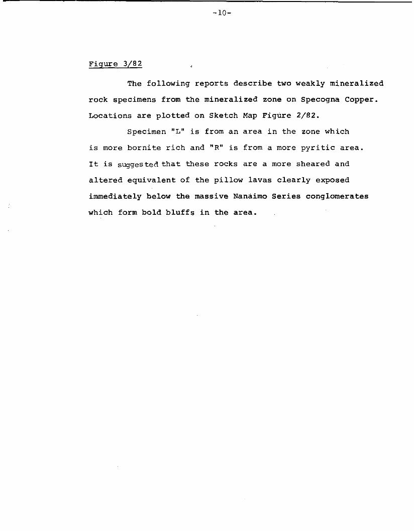
Figure 3/82
The fo l lowing r e p o r t s d e s c r i b e t w o weakly mine ra l i zed
rock specimens from t h e mine ra l i zed zone on Specogna Copper.
Locat ions are p l o t t e d on Sketch Map F igure 2/82.
Specimen "L" is from a n area i n t h e zone which
is more b o r n i t e r i c h and "R" i s from a more p y r i t i c area.
I t i s suggested t h a t t h e s e rocks are a more sheared and
a l t e r e d e q u i v a l e n t of t h e p i l l o w lavas c l e a r l y exposed
immediately below the massive Nanaimo S e r i e s conglomerates
which form bo ld b l u f f s i n t h e area.
i
! - 1 1 -
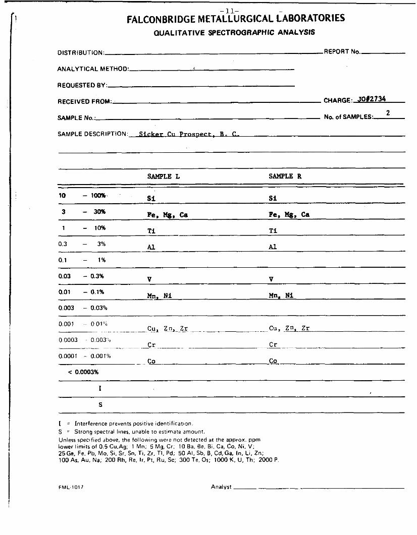
FALCONBRIDGE METAL~URGICAL LABORATORIES OUALITATIVE SPECTROGRAPHIC ANALYSIS
DISTRIBUTION. REPORT No.
ANALYTICAL METHOD.
REQUESTED BY:
RECEIVED FROM: CHARGE: 5012734 " L SAMPLE No.: No. of SAMPLES:
SAMPLE DESCRIPTION.S ickc=r CII P r a s p e r t . R. C.
SAMPLEL SAMPLE R
si si
Re. nP. ~
10 - 1-
3 - 3096
1 - 10%
03 - 390
0.1 - 1%
Pe, nP. Ca Ti Ti
Al Al
V V
Nn. Ni Mn, Ui
0.03 - 0.3%
0.01 - 0.1%
0.003 - 0.03%
0.001 - O O l ' b
0.0003 . 0.003'b
0.0001 - 0.001%
c 0.0003%
~ . cu, L 3 - e -. Cu, -zI, Zr
.. Cr ~ ~~ Cr
- co co
I
S
I = Interference prevents positive identification. S = Strong spectral lines. unable to estimate amount. Unless specified above. the following were not detected at the approx. ppm lower limits of 0.5 Cu.Ag: 1 Mn; 5 Mg, Cr: 10 Ba. Be, Bi. Ca. Co. Ni, V; 25Ge. Fe. Pb. Mo. Si. Sr. Sn. Ti. Zr, TI, Pd; 50 Al. Sb. B, Cd, Ga. In, Li. Zn; 100 As, Au. Na; 200 Rh. Re. l r . Pt. Ru. Sc; 300 Te. Or; 1000 K, U, Th; 2000 P
FML.1011 Analyst I
12- ,:--; FALCONBRIDGE METALLURGICAL LABORATORIES
MINERALOGY REPORT #1160
TO I. L. E l l i o t l /
F R O M J. E. Muir
PROJECT No. 302-800908 (JM2734)
SUBJECT Mineralogical Examination of Two Samples from the "Sicker" Copper Prospec t , B. C.
DESCRIPTION OF SAMPLE: INFORMATION REQUESTED
Two barren samples (L & R) from Efrem Specogna's "Sicker" copper prospect were submitted on J u l y 28th f o r confirmation of t h e i r o r i g i n as va lcan ic s of t h e Permian-age "Sicker Group".
PROCEDURES: fl Spectrochem. Analysis 0 Chemical Analysis X.R.D
a Optical Microscopy 0 Electron Probe 0
RESULTS
Microscopic examination of PTS's 5828 and 5829 prepared from p o r t i o n s of samples L and R r e s p e c t i v e l y confirms t h e i r vo lcan ic o r ig in . Each has been a f f e c t e d by moderate t o s t r o n g s e r i c i t i z a t i o n , ca rbona t i za t ion , s i l i c i f i c a t i o n and c h l o r i t i z a t i o n . The r i m po r t ion c o n s i s t s o f microphenocrysts of s e r i c i t i z e d l a t h - l i k e f e l d s p a r together w i t h fragments of t h e i n t e r i o r por t ion of t h e pi l low s c a t t e r e d throughout a c h l o r i t e ( d e v i t r i f i e d g l a s s ) matrix. The i n t e r i o r o f the pi l low c o n s i s t s of microphenocrysts of s e r i c i t i z e d f e l d s p a r and c h l o r i t i z e d or thopyroxene(?) imbedded i n a f i n e r grained, leucoxene-rich, highly s i l i c i f i e d quench-textured matrix. Late-stage c a l c i t e v e i n l e t s c r i s s - c r o s s t h e sample. Sample R possesses t h e same assemblage as L. but i t is much more equigranular . conta ins a higher propor t ion of a l t e r e d f e l d s p a r l a t h s and i s more i n t e n s e l y carbonat ized. and qua r t z no longer form a somewhat continuous mat r ix but a r e , i n s t e a d , de lega ted
Sample L was undoubtedly c o l l e c t e d from a p i l low margin.
C h l o r i t e
... 2 Fhll 1 U I J
L
- 13- - 2 -
to an interstitial role. Since the chemical compositions of the two samples are similar (see Table I attached), and sample R appears from its texture to have been more slowly cooled than L, then sample R most likely represents the core area of a pillow from the same eruption. The primary mineralogy of the samples as implied by the pseudomorphs now present suggests that both were originally basaltic in composition.
Jpn:sls Attach.
I
-14-
DIAMOND D R I L L I N G
A packsack diamond d r i l l producing EXT core
( abou t one i n c h d iameter ) w a s used, under extremely d i f f i c u l t
c o n d i t i o n s , t o complete f o u r s h o r t h o l e s on t h e p r o s p e c t .
These were designed to test the l i m i t s of m i n e r a l i z a t i o n
from the only f e a s i b l e se t -ups on t h e main p r o s p e c t
( F i g u r e 2 / 8 2 ) .
Complete d r i l l l o g s are a t t a c h e d . I n summary,
DDH #1 h 2 were s h o r t h o l e s near the eastern l i m i t s ( ? )
of t h e p rope r ty and were f i n a l l y abandonned after 3 days
due t o bad ground, p e n e t r a t i n g 7 f e e t (2.1 m) and 1 2 f t
( 3 . 7 m) r e s p e c t i v e l y . DDH # 3 w a s completed t o a proposed
depth of 3 0 . 5 f t ( 9 . 2 m) and DDH # 4 w a s s topped a t 1 5 . 3 f t
( 5 m) due t o f r e e z i n g weather .
SAMPLE PREPARATION AND ASSAY
D r i l l c o r e s w e r e logged and mine ra l i zed sect ions
were s p l i t . Assays f o r copper, z inc , gold and s i l v e r were
c a r r i e d o u t us ing s t anda rd assay methods by General T e s t i n g
Labora to r i e s of Vancouver. Fluoresence sugges t ed t h e
presence of weak s c h e e l i t e m i n e r a l i z a t i o n and select
p i e c e s of c o r e w e r e assayed for WO3.
DRILL CORE STORAGE
Core s p l i t s are r e t a i n e d by Efram Specogna,
1 7 0 4 Cenenary Drive, Nanaimo, B . C .
DRILL RESULTS
D r i l l h o l e s completed appear t o confirm t h a t
mineralization d i p s to t h e east, b u t t h e answer as t o whether
or n o t t h i s p a t t e r n conforms more t o a c r o s s c u t t i n g s h e a r ,
r a t h e r than l o c a l l y d i s t o r t e d bedding, w i l l r e q u i r e more
s tudy . General ized S e c t i o n a l Sketch F igure 4/R2 i l l u s t r a t e s
t h e geometry involved. Any minera l d e p o s i t of s i g n i f i c a n c e
would then occur t o t h e east under an a d j a c e n t 75 t o 100
metres of p o s t mine ra l conglomerate cap rock . Such a
p o s s i b i l i t y i s sugges ted by a s t r o n g VLF anomaly and a
series of i n t r u s i v e s f u r t h e r i n t h i s d i r e c t i o n . A su lph ide
d e p o s i t under t h e unmineral ized cap rock might be d e t e c t e d by
any of s e v e r a l EM " Input" surveys i f s impler methods such
as h o r i z o n t a l co i l EM are inadequate . D r i l l i n g f o r such
a t a r g e t would be f a r s imple r , g iven b e t t e r access, t h a n
t e s t i n g below t h e c l i f f ' i t s e l f due t o t h e low ang le , dip-
s lope topography genera ted by t h e younger ove r ly ing
conglomerates.
CONCLUSIONS
Assay r e s u l t s from d r i l l core sugges t a l o w b u t
s i g n i f i c a n t gold c o n t e n t i n a l l v i s i b l y minera l ized samples.
These are n o t n e c e s s a r i l y p r o p o r t i o n a l t o copper c o n t e n t .
The Specogna Copper p rospec t must be adequate ly
mapped be fo re any e v a l u a t i o n o r meaningful work program
i s at tempted.

- -16-
A
!a4
5 I S
A'
6 Cliff- /. O
Y
L E G E N D
N a n a l m o S o f i e 8 1 c , ) , s s t n )
I'rrl P r o m i n o n ? P i l l o w Loras(bO8altiC)
A l t e r e d V o l c a n i c Tuffs
S i c k e r G p , C h e r t y volc.*8Od
.- D.D.Holo8
I3 6$ 0 Ft. 4 2 0 4 m
13
SCOlS 1:200
G e n a r o l i z e d G e o l o g i c a l C r o r r S e c t i o n A-A'
B o r e d o n S k e t c h M o p F i g . 2 / 8 2
Y . T . s . : W - F - v w e Z E
F I G . N O . : 4 / 8 2
-17-
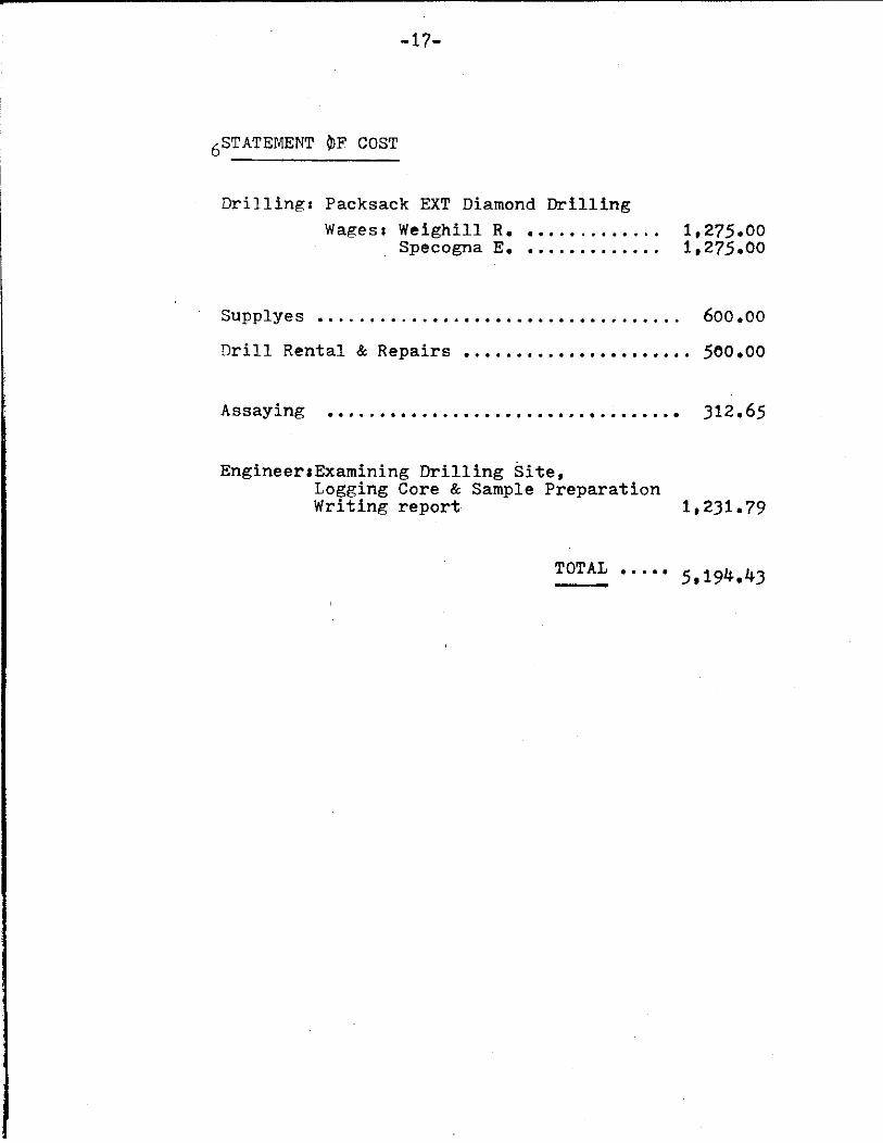
STATEMENT BF COST 6
Drilling: Packsack EXT Diamond Drilling Wages: Weighill R. ............. 1,275.00
Specogna E. ............. 1,275.00
Supplyes ................................... 600.00
Drill Rental & Repairs ...................... 500.00
Assaying .................................. 312.65
EngineertExamining Drilling Site, Logging Core & Sample Preparation Writing report 1,231.79
..... 5,194.43 TOTAL -
- 18-
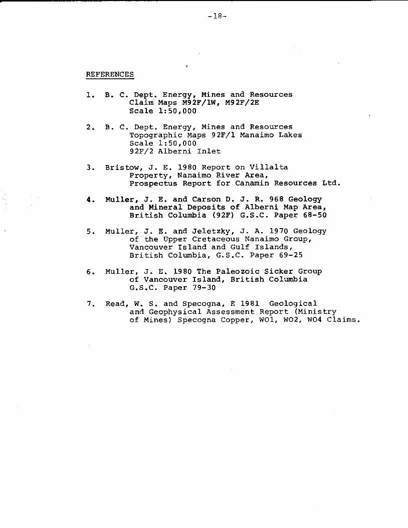
REFERENCES
1. B. C. Dept. Energy, Mines and Resources C l a i m Maps M92F/lW, M92F/2E Scale 1: 50,000
2. B. C. Dept. Energy, Mines and Resources Topographic Maps 92F/1 Manaimo Lakes Scale 1:50,000 92F/2 Albern i I n l e t
3. Bris tow, J. E. 1980 Report on V i l l a l t a Proper ty , Nanaimo River A r e a , P rospec tus Report f o r Canamin Resources Ltd.
4. Muller, J. E. and Carson D. J. R. 968 Geology and Mineral Deposi ts of Alberni Map A r e a , B r i t i s h Columbia (92F) G.S.C. Paper 68-50
5. Muller, J. E. and J e l e t z k y , J. A. 1970 Geology of t h e Upper Cretaceous Nanaimo Group, Vancouver I s l a n d and Gulf I s l a n d s , B r i t i s h Columbia, G.S.C. Paper 69-25
6. Muller , J. E. 1980 The Pa leozo ic S i c k e r Group of Vancouver I s l a n d , B r i t i s h C o l u m b i a G.S.C. Paper 79-30
7. Read, W. S . and Specogna, E 1981 Geologica l and Geophysical Assessment Report (Minis t ry of Mines) Specogna Copper, WO1, W 0 2 , W04 C l a i m s .

-19-
STATEMENT OF QUALIFICATIONS
1) James J. McDougall
Reg i s t e red as a Geologica l Engineer w i t h t h e
Assoc ia t ion of P r o f e s s i o n a l Engineers of B. C . and has
p r a c t i c e d a s a g e o l o g i s t i n B. C . f o r 30 y e a r s . Numerous
assessment r e p o r t s a r e on f i l e .
2) Efram Specogna
A p r o f e s s i o n a l and s u c c e s s f u l p r o s p e c t o r w i t h
over 20 y e a r s exper ience i n B. C. Experience i n v o l v e s
cons ide rab le survey, geophys ica l and geochemical work as
w e l l a s convent ion p rospec t ing techniques .
December 28 , 1 9 8 2
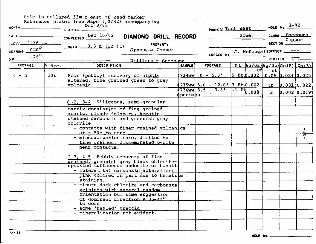
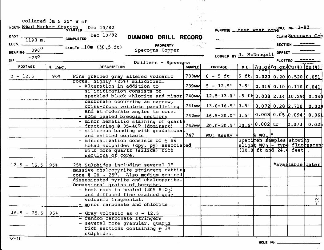
Hole is c o l l a r e d 33m t e a s t of Read Marker Reference p icke t (see Maps 1,2/82) accoIppanying
1-82 HOLE NO. Dec 8 / 8 2
NORTH STARTED wRws T e s t east DIAMOND DRILL RECORD zone % CLAIM -'
copper COMPLETED E A S T
ELEV 1186 m. PROPERTY SECTION
SEARING LENGTH 3 .3 m (12 f t )
J . McDougalloFFsET --- 020° S pecogna Copper LOGGED BY
some s u g g e s t i o n of a- Q 7 5 - 4 5 0 to core - some ' h e a l e d ' b r e c c i a
- m i n e r a l i z a t i o n n o t e v i d e n t .
v- 11. HOLE NO.

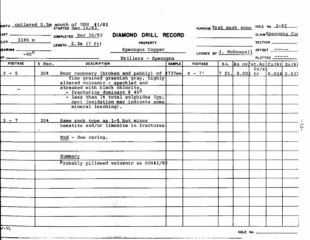
- TH c o l l a r e d 0.5m south of .DDH &/82 p ~ ~ p o ~ T e s t east zone NO. * 8 2
CLAlMSpecoana CQI STARTED lle~ 1n.I
CmpLETED Dec 1 0 / 8 Z DIAMOND DRILL RECORD LEWBln 2.3m (7 ft) PROPERTY
Specogna Copper ----- -----
OFFSET
PLOTTED LOGGED BY J * McDougall
a l t e r e d volcani
I L V N I
c o l l a r e d 3m N 20° W of Dec 10/82 N O R T H R ~ ~ aS%8pED
E A S T COMPLETED DIAMOND DRILL RECORR 1193 m .
0 - 12.5
EL€ V. PROPERTY
B E A R I N G LENGTH L k ! @!! Specogna Copper 090°
90% F i n e g r a i n e d g r a y altered v o l c a n i c 7 3 8 w
- 1 5 0
1 2 . 5 - 1 6 . 5
. - Drl.llnrs - DIP
FOOTAGE I % R e c . DESCRIPTION I I
s e c t i o n s o f core.
95% 25% S u l p h i d e s i n c l u d i n q several 1" mass ive Cha lcoDvr i t e str inaers cu t t inc r
- N W I
- - - A l t e r a t i o n i n a d d i t i o n t o 739w s i i i c i r i c a t i o n c o n s i s t s or s p e c k l e d b l a c k c h l o r i t e and minor 7 4 0 w c a r b o n a t e o c c u r r i n g as narrow, criss-cross v e i n l e t s p a r a l l e l i n s 7 4 1 ~ and a t moderate a n g l e s t o core. - some h e a l e d breccia s e c t i o n s 7 4 2 ~
- minor h e m a t i t i c s t a i n i n s of a u a r t z
1 6 . 5 - 25.5
I - f r a c t u r i n s @ 35 -400 (-t) I 7 4 3 w - -
- s i l i c e o u s band inq w i t h g r a d a t i o n a l
95% - Gray v o l c a n i c as 0 - 12.5
- and c h i l l e d c o n t a c t s I747
I - m i n e r a l i z a t i o n c o n s i s t s o f + 5% 1 t o t a l s u l p h i d e s (cpy , py) associated
I w i t h more q u a r t z ( s i l i ca ) r i c h I
~~
core @ 20 - 256': A l s o medium g r a i n e d [ I d i s s e m i n a t e d p y r i t e and c h a l c o p y r i t e . 1 I O c c a s s i o n a l q r a i n s o f b o r n i t e . I - h o s t rock i s h e a l e d ( 2 0 % SiO,) ,-
and d i f f u s e d f i n e q r a i n e d q r a v v o l c a n i c f r a g m e n t a l . - 1 te
- s e v e r a l more g r a n u l a r , q u a r t z I I r i c h s e c t i o n s c o n t a i n i n q o 2% - -
s u l p h i d e s . v- 11.
OLE NO. 3-132 PURPOSE -8 CLAIM -F
*available
I I I I
1 I I I
HOLE NO.
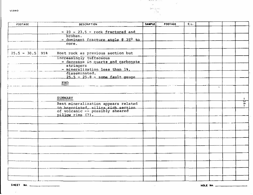
. ..
V15WO
- decrease i
- mineralizat d i s semi na
SHEET No. HOLE NO.

Hole i s c o l l a r e d 2.5m east OfRead r e f e r e n c e p i c k e t
STARTED Dec 12/82 NORTH T e s t w e s t zonWLE %eco&,a 4 82
DIAMOND DRILL RECORD CLAIM Copper . COMPLETE$.W 14/82
LENGTH 5m ( 1 5 . 3 f t l
EAST
ELEV.
BEARING -------- DIP
SECTION ----- OFFSET
PLOTTED -----
PROPERTY 1190 m -----
Specogna Copper LOGGED BY J. McDouqall nri 1 I ~ , - =
- 900 - DESCRIPTION FOOTAGE I C.L. hlJ 0 s-ozA CU(%~ Zn(%
I I I I = I FOOTAGE
I% Rec Q- 9 . 5 ~ 95%
9 . 5 - 1 5 . 3 -m==%L-
v - 1 1 . W E NO.

V15WO
I FOOTAGE I DESCRIPTION
w i n t e r conditions. r
~
I-- I --- zone i n p i l l o w lava sequence. appears t o represent mineralized she
SHEET No. HOLE NO.
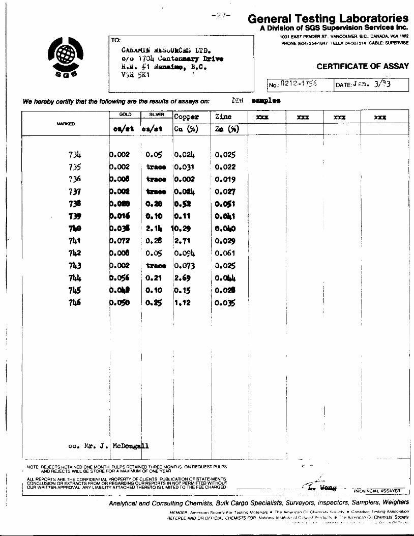
General Testing Laboratories - 7 7 -
A Divlsion of SGS Supervision Selvlces Im. imi EAST PENOER ST v w c w v m B c CAW& VBA rm PHONE (804) 2Y-1647 T E L a Cd-507514 CABLE SuPERvBE
CAhAt4.U kdbaUU&C& LTD. 010 1734 G e n t e m lkivo ii.n. #I LJsPLf.D. B.C. CERTIFICATE OF ASSAY
7% 7 35 7 36 737 7 9 739
I I I I
0.002
0.002 3. a D.Oa D.BPB 0 . M
Wa hereby M i f y that Ihe fdbwing am Ihe results of assays on: &_. mi -1-
IC0PP.r SLVER
ca. Fa. J.
. .
I 0.05 ~0.024
0.28 12.71 0.6 0.w4
'0.073 I
0.21 12.69
I
i 1
I #C 1
0.0% 0.022 0.019
0.027
a051 0.w
a.w 0.029
0.061
0.0%
0.044 0.028 0.0%
m m m xxx I
MOTE REJECTS RETAINED ONE MONTH PULPS RETAINED THREE MONTHS ON REQUEST PULPS AND REJECTS WILL BE STORE FOR A MAXIMUM OF ONE YEAR
N REFOUI, AAE TdE COhFiOEhl A. I 'WPERTY OF C. EhlS PLBLICAl ON OF STbTE MENTS C O N C ~ L S ~ O h O R E I T R A C l S I R O M O R R E G A R D h G ~ R R E P O R l S . N h O T P E R M l T E D ~ 1nOUl I OUn hRlTTEh A P P K N A L A Z I . ABILITY AnACdED TWEREIO 15 L MllED I 0 TdE FEE CdARGED .