kkh56 inqse ch13 p643 688 final.indd · page 643 · 1/1/07...
TRANSCRIPT

643
KH56_INQSE_CH13_p643_688_final.indd · Page 643 · 1/1/07 · 3:21:20 PMKH56_INQSE_CH13_p643_688_final.indd · Page 643 · 1/1/07 · 3:21:20 PM

644
Change. You see it all around you. You see change occurring in your school, in your family, and in your community. An obvious change might
be construction in your community. You probably also notice changes that occur naturally in your body. Change is part of our lives.
But what exactly is a change? How much time needs to pass before you can see a change? Beyond your community, can you see changes that occur in ecosystems or the earth around you? Is there a part of Earth that you heard about recently that had a change such as an earthquake or a volcanic eruption? What was it like in the age of the dinosaurs? There has been a big change in Earth from then to now.
Depending on your perspective, change may be fairly easy to define. For example, you learned in earlier chapters that a change in distance for a given time defines velocity. You measured velocities in several settings. And you saw how reactants changed to make new products in a chemical reaction. If you can identify a change, can you also tell when something else doesn’t change and is constant? For example, is there something in your classroom that is constant?
Time for Change
KH56_INQSE_CH13_p643_688_final.indd · Page 644 · 1/1/07 · 3:21:44 PMKH56_INQSE_CH13_p643_688_final.indd · Page 644 · 1/1/07 · 3:21:44 PM

645Chapter 13 Time for Change
Goals for the Chapter Let’s think more about earth systems. Is it easy to identify when things are constant and when they change? You’ll explore such questions in chapter 13, Time for Change. This will also help you better understand the interactions that occur between the geologic and biological parts of earth systems. In fact, by the end of this chapter, you will learn about
• the rates that tectonic plates move across Earth and the ways that plates interact,
• the driving forces for plate tectonics,
• the patterns and cycles of life on Earth related to plate tectonics,
• the differences between continental drift and plate tectonics, and
• how plate tectonics links with the record of life on Earth (the fossil record).
In chapter 13, you will complete these activities:
Mile High Time Machine
Scaling Up to Mountainous Change
Rates of Plates
Sinking Slabs and Convection Connections
Building Bridges
Falling into the Ocean
Chapter organizers can help you remember what you have learned and where you are headed. They also help you recognize the most important ideas to learn in a chapter. Look at the chapter organizer every day. Think about where you are in its organization. Compare what you know now with what you knew a week ago. Let the chapter organizer help you map your learning and monitor your progress. That way, you can look back and see what you have accomplished.
KH56_INQSE_CH13_p643_688_final.indd · Page 645 · 1/1/07 · 3:21:45 PMKH56_INQSE_CH13_p643_688_final.indd · Page 645 · 1/1/07 · 3:21:45 PM

646
Time for Change
ENGAGE
Mile High Time Machine
Key Idea:You can find evidence of change between an ecosystem today and the same location during the age of the dinosaurs. You do this by comparing plants, animals, and features of the land.
EXPLORE
Scaling Up to Mountainous ChangePart I — Paper Plates
Key Ideas:• Given enough time, small
movements add up to large, geologic changes.
• Models help show the velocity that tectonic plates move on Earth.
Scaling Up to Mountainous Change
Part II — Ups and Downs of Mountains
Key Idea:Tectonic uplift builds mountains, and other forces tear down mountains.
EXPLAIN
Rates of Plates
Key Idea:Tectonic plates interact by crashing together, splitting apart, or grinding past one another.
��
Linking Question
Why do tectonic plates move?
Linking Question
How do many small changes add up to one large, geologic change?
Linking Question
How do tectonic plates interact and change the
surface of Earth?
��
�
���
���
KH56_INQSE_CH13_p643_688_final.indd · Page 646 · 1/1/07 · 3:21:46 PMKH56_INQSE_CH13_p643_688_final.indd · Page 646 · 1/1/07 · 3:21:46 PM

647
Linking Question
Can geologists predict changes in Earth that occur
due to plate tectonics?
CHAPTER
13 Major Concepts
� Different parts of earth systems change at different rates.
� Plate tectonics, mountain building, and erosion have shaped the surface of Earth.
� Tectonic plates interact by crashing together, pulling apart, or grinding past one another.
� Some tectonic events are rapid. It takes many such events over long periods of time to build mountains.
� Many patterns of life on Earth are linked to patterns of plate tectonics.
ELABORATE
Building Bridges
Key Idea:Connections between continents let animals migrate between them. This alters the animal families preserved in the fossil record.
��
�
EXPLORE
Sinking Slabs and Convection Connections
Key Idea:Mantle convection moves heat out of Earth’s interior. Yet a key force in plate tectonics is the downward “pull” on sinking plates at subduction zones.
���
EVALUATE
Falling into the Ocean
Key Idea:Vectors of plate velocities give evidence about where a plate has been and are used to predict where a plate is going.
���
Linking Question
Does plate tectonics affect things like the fossil record of animals on continents?
���
KH56_INQSE_CH13_p643_688_final.indd · Page 647 · 1/1/07 · 3:21:49 PMKH56_INQSE_CH13_p643_688_final.indd · Page 647 · 1/1/07 · 3:21:49 PM

648 Unit 3 Moving Matter
Mile High Time Machine Time machines. They are a favorite of science fiction thrillers. They can propel you into the future with space travel through wormholes, as you eat nourishing meals of orange-flavored capsules. Time machines in science fiction can also send you back in time. They can propel you back to the American Revolution, the signing of the Declaration of Independence, or the building of the pyramids in Egypt. But imagine that you can dial your time machine back still further in time.
Let’s take a part of North America today—the state of Colorado—in the center of the continent. Denver is a large city near the center of Colorado, with the Rocky Mountains lying directly to the west (figure 13.1). Because its official elevation is 5,280 feet (ft), Denver is called the “Mile High City.” But has Denver always been like that? What would it be like to travel in a time machine to Denver 70 million years ago (Mya)? How has Denver changed since then?
In real life, there is something that acts just like a time machine. It is the geologic record. You’ve studied the geologic record in other parts of this program. In Mile High Time Machine, you will work with a partner to compare scenes around Denver, Colorado, at two very different time periods. What did Denver look like many millions of years of ago? What can you infer from the scenes? Examining scenes around Denver will help you think about other changes on Earth that take a long time.
MaterialsFor each team of 3 students
3 Falling into the Ocean Scoring Rubric handouts
Process and Procedure 1. By yourself, examine and think about the scene from Colorado
in figure 13.1. Answer the following questions about the scene and list your ideas in your science notebook.
a. What kinds of animals do you think are living there? b. What types of plants do you think are living there? c. What evidence do you see for what the climate is like? d. What evidence do you see for what the elevation is like? 2. Get with a partner. Share your ideas about the questions in
Step 1. What inferences can you and your teammate make about the types of animals and plants and the ecosystem?
KH56_INQSE_CH13_p643_688_final.indd · Page 648 · 1/1/07 · 3:21:57 PMKH56_INQSE_CH13_p643_688_final.indd · Page 648 · 1/1/07 · 3:21:57 PM

Chapter 13 Time for Change 649
3. Look at the chapter opener image. It is another scene from central Colorado during the age of the dinosaurs. Pteranodons soar above the shoreline of a continental sea, while dinosaurs like iguanodon amble along warm, palm- and mangrove-lined beaches. With your partner, answer the questions in Step 1 for the scene in the chapter opener.
4. Work as a team to compare the 2 scenes from Colorado, figure 13.1 and the chapter opener.
a. What things are similar between the 2 scenes? b. What things have changed between the 2 scenes?
It will help you to organize your observations in columns of similarities and differences.
5. One of the Colorado images shows mountains. Write in your science notebook all the ideas that you and your partner have for how mountains form.
� Figure 13.1 Rocky Mountain ecosystem today. This scene is just west of Denver, Colorado. How does it compare with scenes of the same area from the geologic past?
KH56_INQSE_CH13_p643_688_final.indd · Page 649 · 1/1/07 · 3:22:02 PMKH56_INQSE_CH13_p643_688_final.indd · Page 649 · 1/1/07 · 3:22:02 PM

650 Unit 3 Moving Matter
Reflect and Connect Discuss the following questions with your partner and write answers in your science notebook.
1. With your partner, estimate how many years ago the scene in the chapter opener occurred. Perhaps you have studied the age of the dinosaurs in other science classes.
Be as specific as you can. It may help you to refer back to chapter 6, Exploring Change. You can modify your answer as you learn more.
2. One image you studied had mammals, and the other had reptiles. What are your current ideas about the differences between mammals and reptiles, such as dinosaurs? Write your ideas in your science notebook. You might consider differences and similarities such as food, habitat, or body features.
3. Discuss with your partner questions you may have about the topography, elevation, or climate for the 2 scenes from the Denver area.
a. Decide on the most interesting question you and your partner have and write it in your science notebook.
b. Can you answer part of the question at this time? Write a possible answer to that question.
Feel free to draw a labeled sketch as well. This is a good way to represent ideas that you are developing in science.
4. Review the 2 scenes of the Denver area. When do you think the Rocky Mountains formed? Use the words before and after to explain your evidence.
You can also draw a sequence of 2 to 3 sketches or diagrams showing this change from coastal plain to sharp-peaked mountains.
Scaling Up to Mountainous Change Denver, Colorado, sure has changed a lot. If you went to Denver in the geologic past, it might have had dinosaurs and sandy beaches at the edge of a continental sea. Plants would have included palms, cypresses, and mangroves—plants typical of warm, tropical climates. Today, the Rocky Mountains at Denver are not at all like this. There are rivers, cold-water fish such as trout in rushing mountain streams, lizards and snakes, and many types of large mammals. The plants and animals—the flora and fauna—have changed rather dramatically.
But how can you explain the changes that occur over long periods of time? For example, how does land change in elevation from sea level
KH56_INQSE_CH13_p643_688_final.indd · Page 650 · 1/1/07 · 3:22:12 PMKH56_INQSE_CH13_p643_688_final.indd · Page 650 · 1/1/07 · 3:22:12 PM

Chapter 13 Time for Change 651
to towering, snowcapped peaks? How long does this take? What sorts of movements affect Earth’s surface and how the surface looks?
In Scaling Up to Mountainous Change, you and two teammates will learn how to scale up from small movements to really large ones. The large movements are truly geologic in scale. You will use simple paper plates to simulate Earth movements.
Part I: Paper Plates
MaterialsFor each team of 3 students
1 timer or stopwatch
1 paper plate
1 small plastic animal
1 pair of scissors
1 length of masking tape (15 cm)
1 meterstick
1 calculator
1 red pen
1 Lower 48 States Map handout
Process and Procedure 1. Obtain 1 paper plate for your team. Cut the plate in the shape
of your favorite continent and attach a plastic animal to the plate. Cut or tear the masking tape into 10–15 small pieces.
2. Clear a path across the surface of your team’s work surface (your desk, a large table, or a lab counter). Place a piece of tape as a marker every 10 centimeters (cm). Do this across the length of the table.
3. Move your paper plate with your hand from one end of the work surface to the other at a constant rate of 10 centimeters per 5 seconds (10 cm/5 sec).
It may help to designate one teammate as timer and one as recorder.
4. How long does it take for your paper plate to move from one end of your work surface to the other end? Show your answer in seconds and in minutes. Explain in your science notebook 2 different ways that you could determine the time.
5. Return the plate to its initial spot. You and your teammates will scale up the movement of the paper plate. You will calculate how long it would take for the paper plate to move to 2 other locations in your school at 2 cm/sec.
Your teacher may write an estimate of distance on the board. Or your class might use other locations if you know their distances.
KH56_INQSE_CH13_p643_688_final.indd · Page 651 · 1/1/07 · 3:22:17 PMKH56_INQSE_CH13_p643_688_final.indd · Page 651 · 1/1/07 · 3:22:17 PM

652 Unit 3 Moving Matter
Figure 13.2 will help you organize your calculations. Record all your work in your science notebook. a. Rewrite your plate’s velocity from Step 3 as seconds per
centimeter (sec/cm). b. Convert this rate to units of seconds per meter (sec/m). c. What is this rate in units of minutes per meter (min/m)?
LocationDistance (meter, or m)
Time (minute, or min)
Time (hour, or hr)
Cafeteria
Principal’s offi ce
Gymnasium
� Figure 13.2 Timetable for recording the distances of the paper plate. Use a table like this to help organize the distances and times for a paper plate to move to areas like these at a rate of 2 cm/sec. Under the table, show all work and the units canceled.
6. For a paper plate with a velocity of 10 cm/5 sec (or 2 cm/sec), use Steps 6a–f to show how far the plate moves in 1 year. Show all work in your science notebook.
a. Write the velocity in units of centimeters per 1 second (cm/sec).
b. Convert the velocity to units of centimeters per minute (cm/min).
c. Convert the velocity to units of centimeters per year (cm/yr). d. Scale up by converting the velocity to units of meters per
year (m/yr). e. Scale up again to units of kilometers per year (km/yr). f. Check your conversion for Step 6e again with your team.
When your team thinks you have it, run it by your teacher.
A vital skill that will help you is canceling the units in the numerator and the denominator. Check that you and your teammates understand how to do this.
7. How many years would it take to move your plate to a farther location using the same velocity (km/yr) from Step 6e? Follow Steps 7a–d to find out.
a. Obtain for your team 1 copy of the handout Lower 48 States Map. Place a red star at the location of your school.
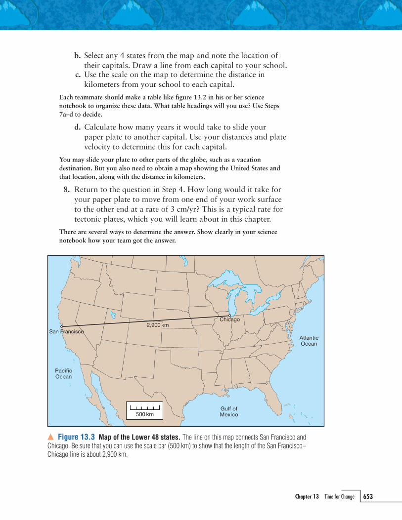
Figure 13.3 is a map of the Lower 48 states with a line from San Francisco, California, to Chicago, Illinois. Be sure that you and your teammates can use the scale on the map to show that the line is about 2,900 kilometers (km) long.
KH56_INQSE_CH13_p643_688_final.indd · Page 652 · 1/1/07 · 3:22:22 PMKH56_INQSE_CH13_p643_688_final.indd · Page 652 · 1/1/07 · 3:22:22 PM
Chapter 13 Time for Change 653
b. Select any 4 states from the map and note the location of their capitals. Draw a line from each capital to your school.
c. Use the scale on the map to determine the distance in kilometers from your school to each capital.
Each teammate should make a table like figure 13.2 in his or her science notebook to organize these data. What table headings will you use? Use Steps 7a–d to decide.
d. Calculate how many years it would take to slide your paper plate to another capital. Use your distances and plate velocity to determine this for each capital.
You may slide your plate to other parts of the globe, such as a vacation destination. But you also need to obtain a map showing the United States and that location, along with the distance in kilometers.
8. Return to the question in Step 4. How long would it take for your paper plate to move from one end of your work surface to the other end at a rate of 3 cm/yr? This is a typical rate for tectonic plates, which you will learn about in this chapter.
There are several ways to determine the answer. Show clearly in your science notebook how your team got the answer.
� Figure 13.3 Map of the Lower 48 states. The line on this map connects San Francisco and Chicago. Be sure that you can use the scale bar (500 km) to show that the length of the San Francisco–Chicago line is about 2,900 km.
KH56_INQSE_CH13_p643_688_final.indd · Page 653 · 1/1/07 · 3:22:28 PMKH56_INQSE_CH13_p643_688_final.indd · Page 653 · 1/1/07 · 3:22:28 PM
654 Unit 3 Moving Matter
Part II: Ups and Downs of Mountains
MaterialsFor each team of 3 students
1 ruler
1 calculator
colored pencils
3 Mountain Profiles handouts
Process and Procedure In Part I, your paper plate moved in a horizontal direction. The plate moved across surfaces and around your school. You even imagined it moving to other states. Because the paper plate had a velocity, you could determine how far it would go in an amount of time. But what other directions do things move besides back and forth? In unit 1, Interactions Are Interesting, you studied objects moving back and forth, as well as up and down.
How about mountains? You saw that tectonic plates move across Earth at rates of roughly 3 cm/yr. How does this compare with how fast mountains can be pushed up? Work with your team to do the following activity. It will help you understand how fast mountains grow and how fast they can change Earth’s surface.
PART I
Answer the following question about paper plates with your team.
1 Compare the velocity of your paper plate in Step 6 with the movements of continents over the surface of Earth. Except for Australia, continents move about 3 cm/yr.
a. What step from Step 6 has units that are easiest to compare with a velocity of 3 cm/yr? Explain why.
b. Is the paper plate’s or a continent’s velocity faster? How different are the 2 velocities?
Recall that this type of question is best answered with a ratio. A ratio tells you how many times bigger or faster one number is than the other.
KH56_INQSE_CH13_p643_688_final.indd · Page 654 · 1/1/07 · 3:22:33 PMKH56_INQSE_CH13_p643_688_final.indd · Page 654 · 1/1/07 · 3:22:33 PM

Chapter 13 Time for Change 655
1. With your team, view the flat-topped coral terrace in figure 13.4. Then read the following paragraph.
You learned in the last chapter that the sea level has changed between glacial and interglacial periods. When the sea level drops, a reef ecosystem will be stranded above sea level and will die. The stranded, flat-topped part of the coral reef is called a terrace. You learned that radiometric dating of corals can measure when the sea level last covered the terrace with 1–2 meters (m) of water. The terrace in figure 13.4a formed during a sea level high about 125,000 years ago (125 kya). (Remember, kya means thousands of years ago.) The sea level then was about 5 m above the current sea level.
2. Imagine you’ve just returned from exciting geological fieldwork in Papua New Guinea. Papua New Guinea is an area of active mountain formation located just north of Australia. Your work and diagrams show coral terraces on a hillside (figure 13.5.) Complete Steps 2a–f to determine the geologic history of the coral deposits.
a. Write down the relationship you observe between the age of the corals and the elevation on the hillside.
Note that all these terraces formed during sea level highs, or interglacials. How do the ages of the terraces compare with the climate patterns in chapter 12, Evidence for the Ice Ages?
� Figure 13.4 Exposed coral reef, Bahamas. (a) This flat-topped, exposed coral terrace is at San Salvador, Bahamas. The top of this coral terrace is about 5 m above the current sea level. The close-ups (b and c) show fossil corals in the terrace.
coral terrace
a. b.
c.
KH56_INQSE_CH13_p643_688_final.indd · Page 655 · 1/1/07 · 3:22:39 PMKH56_INQSE_CH13_p643_688_final.indd · Page 655 · 1/1/07 · 3:22:39 PM

656 Unit 3 Moving Matter
b. Explain the relationship you identified in Step 2a. That is, what does this relationship tell you about the geologic history of this hillside over the past 350,000 years (350 kyr)? (Remember, kyr means thousands of years.)
Make a quick sketch of figure 13.5 in your science notebook and complete the phrases “What I see” and “What it means.”
c. Use a strategy to organize your observations of elevation (in meters) as a function of coral age (in thousands of years). Do this in your science notebook.
d. Make a graph to determine a rate of change shown by these data.
Recall that rates show a change in something per amount of time. Extend time on your graph out to 400 kya.
e. Draw a best-fit line through these data with a pencil and determine the value of the slope. Be sure to check the units for your slope. This is the uplift rate.
It may help your team to review the How To section on determining slopes: How to Use Graphs, Measure Slopes, and Estimate Uncertainty located in the back of your book.
f. Use highlight comments on your graph (“What I see,” “What it means”) to explain what the slope on the graph indicates about this region of Papua New Guinea.
3. Complete Steps 2a–f for figure 13.5b for a colleague’s diagram. She has just returned from mapping coral terraces on the island of Barbados, an area of active mountain formation in the Caribbean Sea. Add these data for Barbados to the graph you did in Step 2 for Papua New Guinea.
You can use a different symbol or color for these data.
4. Develop a sentence with your team comparing the Papua New Guinea and the Barbados data in your graph.
5. How does the upward movement of coral terraces relate to the making of mountains? Read the following paragraph to learn more about the rates at which mountains are made.
World maps show continents, oceans, or countries. But it can be hard to tell from maps where mountains are growing. In active mountains, such changes are happening all the time. Maybe the evidence is an occasional earthquake or a volcanic eruption. Pushing the land up to form mountains is called uplift. Examples of active uplift include the Andes mountains, the islands of New Zealand, the Himalaya mountains, and
KH56_INQSE_CH13_p643_688_final.indd · Page 656 · 1/1/07 · 3:22:50 PMKH56_INQSE_CH13_p643_688_final.indd · Page 656 · 1/1/07 · 3:22:50 PM

Chapter 13 Time for Change 657
parts of the Middle East and western North America. In these areas, uplift rates can be as high as �10 millimeters per year (mm/yr). That may not sound like a lot, but with a lot of time, this uplift can make massive mountains.
6. Uplift over geologic lengths of time is harder to envision than small uplifts each year. Work through Steps 6a–d to estimate how many kilometers can be uplifted in 1 million years (Myr).
� Figure 13.5 Coral terraces in (a) Papua New Guinea and (b) Barbados. The geologic diagrams show coral terraces cut into hillsides on Papua New Guinea and Barbados. Radiometric dating tells the age when the corals were living at sea level (as thousands of years ago, or kya). Examples of fossilized tree and brain coral appear in figure 13.4. Living examples are in chapter 12.
KH56_INQSE_CH13_p643_688_final.indd · Page 657 · 1/1/07 · 3:22:55 PMKH56_INQSE_CH13_p643_688_final.indd · Page 657 · 1/1/07 · 3:22:55 PM

658 Unit 3 Moving Matter
a. Study figure 13.6 with your partner. Copy it into your science notebook.
b. Fill in all the blank cells in the “distance” column so that they correspond with the “time” column.
Note that distance must also correspond with the units in the right-hand column.
c. Identify the row or rows in figure 13.6 that correspond to 1 kyr. Explain why in your science notebook.
d. Compare the following uplift rates. Explain your answer in your science notebook.i. 2.5 millimeters per year
(mm/yr)ii. 2.5 meters per thousand
years (m/kyr)iii. 2.5 kilometers per million
years (km/Myr)
Time (yr) Distance Units for distance
1 2.5 mm
10 mm
100 mm
1,000 mm
1,000 m
10,000 m
100,000 m
1,000,000 m
1,000,000 km
1 million � 1 � 106 km
� Figure 13.6 Rates for scaling up tectonic uplift. Tectonic uplift in mountains is a slow process. Uplift occurs over millions of years. Complete this table for an uplift rate of 2.5 mm/yr. This will help you estimate how much uplift can occur in 1 Myr.
7. Read FYI—Weather to Erode. This will help you learn about 2 processes that describe how mountains wear down: weathering and erosion. Refer to this FYI in Steps 8 and 9.
8. You just looked at uplifted coral terraces. Now do Steps 8a–f to start thinking about how chains of mountains form.
a. Locate the Himalaya on a map. The Himalaya mountains have the highest elevations on Earth. They have been forming for 30–40 Myr. The limestone at Mount Everest (the highest peak on Earth) shows that those rocks were near sea level in the past (figure 13.7).
b. Determine how much uplift occurs in 1 Myr when there is an uplift rate of 2.5 mm/yr.
Use your work in Step 6 and figure 13.6 to help with this conversion.
c. Determine how high a mountain such as Mount Everest would grow in 10 Myr with an uplift rate of 2.5 mm/yr.
d. Geologic evidence shows that Mount Everest has grown to about 8,850 m (29,035 ft) in about 30 Myr. Compare this with your result in Step 8b.
A good way to make comparisons is to use words like “greater than” and “less than” or to estimate how many times slower or faster something is.
KH56_INQSE_CH13_p643_688_final.indd · Page 658 · 1/1/07 · 3:23:02 PMKH56_INQSE_CH13_p643_688_final.indd · Page 658 · 1/1/07 · 3:23:02 PM

Chapter 13 Time for Change 659
You certainly have experienced things wearing
out. Perhaps it’s your shoes, your car’s tires, a soccer
ball, or a pencil eraser. An object loses mass as small
bits or fragments of material are taken away.
But by “wear out,” you also could mean a
chemical change. Maybe wear out refers to the
chemical reaction in batteries as they lose their
“juice.” Or perhaps the change is the deterioration
of lawn furniture exposed to rain and solar radiation.
What about a hammer left out in the rain? It gets a
rust coating that can be wiped off with your finger.
Mountains wear out, too. And just like car tires
and outdoor lawn furniture, they do it by chemical
and physical processes. Think about a rock outside,
on a mountain, or even on a building’s facade. As
the rock is exposed to the weather, minerals in
the rock begin subtle chemical changes. A good
analogy is the hammer—iron metal turns to iron
oxide, or rust. The process of the natural chemical
alteration of minerals is called weathering. Water is
often part of a weathering change.
Chemical changes by themselves, however, do
not decrease the mass of the rock. Another process
must move matter away. This is how mountains
can wear down. Erosion is the process where
weathered rock fragments and soils are transported
Weather to Erodeand moved downward due to gravity. Erosion of
mountains occurs along steep slopes and river
valleys. Erosion by flowing rivers moves sand and
silt away from mountains and closer to oceans.
Some parts of rocks, such as carbonate or salt
deposits, will even dissolve right into rivers and be
carried away to the ocean.
How long does it take for mountains to weather
and erode? How would you tell this? Effects that
you might notice are a decrease in elevation or a
gentle rounding of mountain peaks. An easy way
to estimate the decrease in elevation is with the
concept of half-lives. You already used half-lives in
chapter 6 with radioactive elements. For mountains,
the erosion half-life is the time needed for the
elevations of a profile to decrease by about half.
Consider mountains made of hard granite that
have an average elevation of 12,000 ft and an
erosion half-life of 10 Myr (see the graph). After
about 10 Myr (one half-life), the elevation would
have been reduced by about 6,000 ft to an elevation
of about 6,000 ft. After a total of 20 Myr (two half-
lives), the elevation would have decreased by about
9,000 ft, to an elevation of about 3,000 ft.
This is a simple way to quantify how Earth’s
surface wears out. Of course, Earth is much more
complex than radioactive isotopes in
decay. Still, it’s nice to have a good rule
of thumb to
help learn
about rates of
erosion and
weathering.
� Graph showing erosional half-lives of mountains. This graph shows the average elevation of mountains with time due to erosion. The average elevation decreases by half every 10 Myr. How tall will the mountains be in about 40 Myr?
Go to: www.scilinks.orgTopic: weatheringCode: 2Inquiry659aTopic: erosionCode: 2Inquiry659b
KH56_INQSE_CH13_p643_688_final.indd · Page 659 · 1/1/07 · 3:23:07 PMKH56_INQSE_CH13_p643_688_final.indd · Page 659 · 1/1/07 · 3:23:07 PM

660 Unit 3 Moving Matter
e. Discuss with your teammates the factors or processes on Earth that can help explain the comparison in Step 8d.
What factors or processes can you think of that make mountains appear to be growing more slowly than the actual uplift rate? What would you expect in the areas between mountain peaks in the Himalaya?
f. Examine figure 13.7 with your teammates. What evidence in the figures supports the idea that the peaks may not grow at 2.5 mm/yr, even when they are being pushed up that fast?
9. Obtain 3 copies of the Mountain Profiles handout. Then follow Steps 9a–e to see how a mountain chain such as the Appalachians changes when it is not being uplifted.
a. With your teammates, trace your fingers over the profile of elevation in the handout. Label the elevations of the peaks and valleys on your handout.
b. The profile mimics a mountain chain like the Appalachians, which has an erosion half-life of about 5 Myr. On your diagram, draw a prediction for the elevations of the peaks and valleys in about 5 Myr.
Connect points with lines to make a full profile. Use colored lines or labels to help indicate the future profile of elevation.
c. Use the concept of erosion half-life again to predict the elevations of the peaks and valleys after another 5 Myr (10 Myr total). Draw your prediction on your diagram.
What color will you use for this line? How will you organize your different profiles in a legend?
d. Explain how you can predict the elevation profile 5 Myr before the initial profile on the handout.
e. The erosion half-life model is a good tool for making predictions. List in your science notebook possible limitations to this tool.
10. In Step 2, you investigated a region of current tectonic uplift in Papua New Guinea.
a. Look up the tectonic uplift rate you determined in Step 2. b. With your team, list how erosion and uplift affect mountains.
Write in your science notebook what you think would happen if these processes were occurring at the same time.
c. Predict how the erosion half-lives for mountains like the Appalachians in Step 9 might compare with the erosion half-lives in other areas. Geologists have shown that conditions at Papua New Guinea give an erosion half-life of about 1 Myr. Rocks there are loose volcanic rocks on steep slopes that get heavy tropical rains.
KH56_INQSE_CH13_p643_688_final.indd · Page 660 · 1/1/07 · 3:23:16 PMKH56_INQSE_CH13_p643_688_final.indd · Page 660 · 1/1/07 · 3:23:16 PM

Chapter 13 Time for Change 661
a.
b.
� Figure 13.7 Two views of the high Himalaya. (a) The map extends from Iran to China and is centered on the high Himalaya. The star marks Mount Everest. (b) The diagram shows the same region with the land tan, the ocean blue, and major rivers superposed.
KH56_INQSE_CH13_p643_688_final.indd · Page 661 · 1/1/07 · 3:23:21 PMKH56_INQSE_CH13_p643_688_final.indd · Page 661 · 1/1/07 · 3:23:21 PM

662 Unit 3 Moving Matter
d. What is the change in elevation for mountains when the rate of erosion equals the rate of uplift? Write your ideas in your science notebook.
Reflect and Connect Discuss the following questions with your teammates. Write your answers in your science notebook.
1. View the 5 overhead transparencies of patterns around Earth that your teacher will show you. Share with the class the patterns you see about where earthquakes, volcanoes, continents, and several other geologic features occur.
2. How do you think animals might respond to tectonic movements of several centimeters per year? Consider a tectonically active region like California or the Pacific Northwest. Do you think an earthquake could change ecosystems? Explain your reasoning.
3. Consider rates of plate movement of 15 mm/yr. Sometimes these movements don’t occur at a steady pace of 15 mm/yr, but rather happen in sudden lurches. Consider an earthquake that gives a sudden movement of 2 m. How often would events with 2 m of displacement occur to give a net rate of 15 mm/yr?
Rates of Plates You have probably heard that rates can be used to indicate change. Rates tell how fast something happens. For example, velocity tells how distance changes in a given time, as you saw in earlier chapters. Maybe the rate is for a paper plate moving in your classroom. Or maybe you’re investigating slow, steady velocities in the up-down direction, such as with the uplift of mountains.
But what sorts of patterns would these movements make on the surface of Earth? How do geologic movements relate to paper plates? How could movements across a surface lead to uplift?
MaterialsFor each team of 3 students
1 ruler
1 calculator
3 South America and Africa handouts
Process and Procedure Complete the following reading with two teammates to learn more about tectonic plates on Earth. Follow your teacher’s instructions about using a strategy to better understand and share ideas from the reading.
KH56_INQSE_CH13_p643_688_final.indd · Page 662 · 1/1/07 · 3:23:28 PMKH56_INQSE_CH13_p643_688_final.indd · Page 662 · 1/1/07 · 3:23:28 PM

Chapter 13 Time for Change 663
Crash, Stretch, and Grind
It’s a major scientific discovery of the past 50 years. It’s a unifying theory for understanding the surface of Earth. It helps explain the continents, the location of mountains and oceans, natural resources, climate patterns, biological evolution, and many other phenomena. Have you heard of it? It’s the theory of plate tectonics. You likely studied plate tectonics in middle school. This theory explains the formation of some of the largest features and structures on Earth. The plate tectonics theory holds that 12 or so rigid plates move slowly over Earth. They travel atop the Earth’s mantle. These plates interact in a number of ways and affect virtually everything in the earth system. Continents ride above sea level and are important parts of several tectonic plates. These parts of plates consist of continental crust, the basic rock material of the continents. But
there is more to tectonic plates than continents. The other main part is denser than continents and lies beneath the ocean. Rocks in this part of the plate make up what is called oceanic crust (figure 13.8). In many cases, the same plate includes both continental and ocean crust. An example is the eastern margin of the North American Plate. There, continental crust meets oceanic crust at the Atlantic shore (figure 13.9). The South American and African plates are also much larger than their continents alone. In contrast, one of Earth’s largest plates, the Pacific Plate, is made up almost entirely of oceanic crust. The Pacific Plate does not have any continents, but only fragments of continental crust in some areas. You’ll learn more about this later in the chapter.
� Figure 13.8 Internal structure of Earth. Earth consists of several layers arranged like the layers of an onion. Tectonic plates of oceanic crust or continental crust move slowly atop the mantle of Earth.
KH56_INQSE_CH13_p643_688_final.indd · Page 663 · 1/1/07 · 3:23:30 PMKH56_INQSE_CH13_p643_688_final.indd · Page 663 · 1/1/07 · 3:23:30 PM

664 Unit 3 Moving Matter
Another important idea led to the theory of plate tectonics. This was continental drift, the idea that continents drift slowly across Earth’s surface. This idea has proven correct. But, you can also now see that tectonic plates consist of much more than drifting continents. All ocean floors are also part of moving plates. To better understand tectonic plates, you must look at their interactions. What happens where plates come together? What about where they split apart? Do these interactions affect humans? Where plates meet, they can interact in three general ways. They can either crash, stretch and split apart, or grind past each other. A way to describe these interactions is as three main tectonic settings. To help you answer those earlier questions, read on to learn more about these interactions.
Tectonic Setting 1: Crash—Colossal Collisions
Collisions are dangerous, especially when you are in a car. In a car collision, a car and an object come together too fast. The area where they meet has several characteristic shapes. Some of those shapes are shown in figure 13.10. What evidence do you see to indicate a collision? Tectonic collisions are similar to car collisions. Of course, a tectonic collision is much slower. But still, zones of collision can be thousands of kilometers long. These collision zones form long chains of mountains. They are distinct areas of uplift, just like the area on the car hood in figure 13.10. Sometimes the collision zones occur when regions of continental crust crash together
� Figure 13.9 Tectonic plates of Earth. This map shows the 12 main tectonic plates on Earth. Note that plates can consist of continents as well as large areas of ocean and oceanic crust. Tectonic plates are more than just continents.
Crash, Stretch, and Grind, continued
KH56_INQSE_CH13_p643_688_final.indd · Page 664 · 1/1/07 · 3:23:35 PMKH56_INQSE_CH13_p643_688_final.indd · Page 664 · 1/1/07 · 3:23:35 PM

Chapter 13 Time for Change 665
(figure 13.11). Because the crust comes together, or converges, at the edges of plates, such areas are called convergent zones. Examples include the Himalaya, the Alps, and the Appalachian mountains. At other times, the parts of tectonic plates made of oceanic crust collide with continents. These are also convergent zones since plates are crashing together. Because the oceanic crust
is more dense than continental crust, it is thrust downward, or subducted, beneath the continent (figure 13.11). This dense oceanic crust then sinks into the mantle.
Several large tectonic features form where oceanic crust sinks into the mantle. The down-going crust forms subduction zones. Deep trenches on the ocean floor indicate where ocean crust is being subducted. The subducted oceanic crust is sometimes called a slab. Lines of volcanoes above subduction zones are called volcanic arcs. For example, a deep trench and line of volcanoes are found as the Juan de Fuca Plate is subducted beneath North America in the Pacific Northwest (figure 13.11). They are called
volcanic arcs because of their broad, curved shape. Examples are the Indonesian and Caribbean volcanic arcs in figure 13.9 and the spectacular Aleutian and Japan arcs.
� Figure 13.10 Car collision. This car has collided with a pole. What evidence do you see to indicate the collision?
� Figure 13.11 Two tectonic collisions. Collisions between (a) continents and (b) oceanic crust and continental crust result in chains of mountains. Regions where oceanic crust is pushed beneath continental crust are called subduction zones.
Go to: www.scilinks.orgTopic: theory of plate tectonicsCode: 2Inquiry665aTopic: subduction zonesCode: 2Inquiry665bTopic: volcanic arcsCode: 2Inquiry665c
KH56_INQSE_CH13_p643_688_final.indd · Page 665 · 1/1/07 · 3:23:42 PMKH56_INQSE_CH13_p643_688_final.indd · Page 665 · 1/1/07 · 3:23:42 PM

666 Unit 3 Moving Matter
Work with your teammates to complete the following tasks about tectonics.
1 Use a T-table to group the tectonic plates in figure 13.9.
a. In the left-hand column, list plates consisting of both continental and oceanic crust.
b. In the right-hand column, list plates made up of oceanic crust.
2 The ocean is deepest at the Mariana Trench, at about 11 km deep (figure 13.9). What kind of plate boundary do you think this is, and what is your evidence? What tectonic features are found there?
3 Figure 13.12 shows 5 positions of India in the past 71 Myr. The collision between India and Eurasia made the Himalaya. What was the tectonic velocity for India on its journey to this colossal collision?
a. For each of the 5 positions shown, draw a small, dark circle on the southern tip of India.
b. Compare the distance of each position with the same point on India today. Measure the distance from tip to tip in centimeters. Enter
� Figure 13.12 Northward tectonic movement of India. India has moved northward over the past 71 Myr. Determine the velocity of India by examining this record of distance and time.
KH56_INQSE_CH13_p643_688_final.indd · Page 666 · 1/1/07 · 3:23:51 PMKH56_INQSE_CH13_p643_688_final.indd · Page 666 · 1/1/07 · 3:23:51 PM

Chapter 13 Time for Change 667
Tectonic Setting 2: Stretch—Breaking Up Is Hard to Do It’s not too hard to imagine tectonic plates crashing together. They’ve been doing that for millions of years! One possible result is that plates collide to form mountains chains. Another result is one plate can be pushed into a subduction zone beneath the other. But what about the opposite? What happens when plates move in opposite directions? What happens when plates are stretched to the limit? Just as with stretching chewing gum or rubber bands, plates will eventually break and begin
to rip apart. Geologists can observe this process happening at many places today on Earth. The point where plates have broken is called a rift. Rifts often form long valleys, or rift valleys. These can be many thousands of feet deep. Examples of rifts on continents are the Rio Grande Rift, extending from northern Mexico to Colorado in the United States. A famous rift is the East African Rift. There, a large fragment of continental Africa is being torn away to the east. The floor of the rift valley provides a rich, unique ecosystem for many species. This rift valley also records the
these measurements in your science notebook in a table like figure 13.13.
c. Use the map scale to convert the centimeters that you measured to kilometers.
d. Plot 5 points on a graph of distance (in kilometers on the y-axis) as a function of time (in millions of years on the x-axis).
e. Use a pencil and ruler to draw a best-fit line through the points. What are the units for the slope of the line on your graph? What does the slope of the line tell you? Explain your answer.
Check that the line goes through zero. It’s OK if the line does not connect all points. This is how you get a quick estimate.
4 Consider again your measurements for India. What if you connect data on your graph from point to point? What inferences can you make about the velocity of India? How might you explain the “low” point on your graph at about 40 Myr?
Time (Myr)Distance
(cm)Distance
(km)
0 0
10
38
55
71
� Figure 13.13 Table for recording India’s tectonics. Use a table like this to record distances for India at the times given in figure 13.12. Use the scale at the bottom of the map to convert centimeters on the map to kilometers on the ground.
Crash, Stretch, and Grind, continued
KH56_INQSE_CH13_p643_688_final.indd · Page 667 · 1/1/07 · 3:24:12 PMKH56_INQSE_CH13_p643_688_final.indd · Page 667 · 1/1/07 · 3:24:12 PM

668 Unit 3 Moving Matter
history of hominids (the family and ancestors of humans) in many famous fossil finds. Continental rifts can grow wider and wider with more stretching. They also can get deeper, leaving the land surface below sea level. When these rift valleys meet the ocean, marine waters can move in to submerge the floor of the rift valley. Modern examples of this are the Red Sea and the Gulf of California. Rifts are not only found on continents. In fact, the largest system of rifts on Earth is found beneath the ocean where tectonic plates are moving apart, or diverging. Rift zones are sometimes called divergent zones. These rifts form wide ridges of high topography, even though they are underwater. The areas of rifting are sometimes called mid-oceanic ridges due to their historic link with the ridge down the center of the Atlantic Ocean. This long oceanic ridge is also a divergent boundary (figure 13.9) between spreading plates. Figure 13.9 also shows that not all oceanic ridges are in the centers of oceans.
Tectonic Setting 3: Grind—Living on the Edge How do tectonic plates interact when they are not crashing together or pulling apart? Parking lots offer a clue. Have you ever seen a car try to squeeze through a space that is too small? The result could be a dramatic screeching and grinding as one car scrapes past the other. Tectonic plates do the same thing. The surface where the two plates grind past each other is called a transform fault. Perhaps the best-known transform fault between two plates is on the southwest part of North America.
Crash, Stretch, and Grind, continued
� Figure 13.14 North Anatolian and San Andreas faults. These maps show two transform faults: (a) the North Anatolian Fault and (b) the San Andreas Fault. Each fault has ruptured in massive earthquakes during the past 100–200 years. The net movement along each fault is several centimeters per year, about the growth rate of your fingernails.
KH56_INQSE_CH13_p643_688_final.indd · Page 668 · 1/1/07 · 3:24:31 PMKH56_INQSE_CH13_p643_688_final.indd · Page 668 · 1/1/07 · 3:24:31 PM

Chapter 13 Time for Change 669
There, the San Andreas Fault marks where the Pacific Plate is grinding its way northwest along the edge of the North American Plate. A massive lurch along the San Andreas Fault was the cause of the massive 1906 earthquake in San Francisco. This earthquake and the fires that resulted destroyed three-quarters of San Francisco and killed more than 3,000 people. Other devastating earthquakes have struck along the San Andreas Fault since 1906. A massive earthquake in October 1989 hit the San Francisco Bay area in the middle of the World Series between the San Francisco Giants and the Oakland Athletics. The death toll was 65, with thousands injured and an estimated $8 billion of damage. Another example of a transform fault on a continent is the North Anatolian Fault in Turkey (figure 13.14). It also has a dangerous history of sudden movements, violent earthquakes, and significant damage and deaths. Geologists used to think that transform faults were sharp zones of slip between rigid blocks. But modern technology shows that this is only part of the story. For example, geology clearly shows a history of movement exactly on the San Andreas Fault. At the same time, sensors show that the total slip at the boundary is spread over a zone about 200 km wide. The increasing total slip is shown by longer and longer
velocity vectors as one moves from Nevada to the ocean near San Francisco (figure 13.15). The same is true in Southern California, where the fault slip is spread across a wide region. So boundaries between tectonic plates may be shown on maps as distinct faults. In reality, transform faults can be broad zones of broken rock that are tens to hundreds of kilometers wide. Large earthquakes will likely occur within these zones. Similarly, wide zones of mountains show that collisions between plates do not form only a single fault. The boundaries are broad and dynamic.
� Figure 13.15 San Andreas Fault slip. Vectors indicate the slip in an east-west cross section of California. The slip relates to deformation centered on the San Andreas Fault. Arrows show velocity of points relative to stable parts of North America (for example, Missouri).
Topic: rift valleysGo to: www.scilinks.orgCode: 2Inquiry669
KH56_INQSE_CH13_p643_688_final.indd · Page 669 · 1/1/07 · 3:24:37 PMKH56_INQSE_CH13_p643_688_final.indd · Page 669 · 1/1/07 · 3:24:37 PM

670 Unit 3 Moving Matter
Reflect and Connect 1. Basins in rifts on continents, like the Rio Grande Rift, can be
over 10 km deep. Why do you think they appear as broad valleys instead of deep troughs that are 10 km deep? What processes can you infer are occurring in the land or mountains on the flanks of the rifts?
Think back to the last activity. What factor makes mountain peaks never really grow at the rate of tectonic uplift?
2. Models are a key part of science. In geology, simple block models can show how tectonic plates move past each other. Compare the blocks in figure 13.16 with the velocity vectors in figure 13.15. Which block model do you think most accurately shows slip between the Pacific and North American plates? Use sketches of block models in your answer to explain.
3. What does the future hold for the geology of the Middle East? Predict the tectonic changes and evolution of the Middle East in the next 10 Myr.
a. The Arabian Plate is moving away from Africa with a velocity of 20 mm/yr (figure 13.17). How far will the Arabian Plate move in 10 Myr?
b. Where do you predict zones of rifting? Where do you predict zones of collision?
Remember that velocities for the Arabian and Eurasian plates are relative to Africa. This is as if you were standing on the African Plate and noting the Arabian Plate moving away from you at 20 mm/yr, while the Eurasian Plate got closer by 10 mm/yr.
c. What do you predict will happen to the Red Sea? To the Persian Gulf?
d. Develop a sketch of the geography of the Middle East in 10 Myr.
For example, what will be the width of the Red Sea? Use the scale to diagram the future Red Sea.
� Figure 13.16 Block models of slip at faults. The 3 models illustrate how plates deform as they slide past each other. Which model do you think most closely relates to the data—the current velocity vectors—along the San Andreas Fault (figure 13.15)? Note the style of faulting, not the direction of the arrows.
KH56_INQSE_CH13_p643_688_final.indd · Page 670 · 1/1/07 · 3:24:44 PMKH56_INQSE_CH13_p643_688_final.indd · Page 670 · 1/1/07 · 3:24:44 PM

Chapter 13 Time for Change 671
e. Consider an African elephant that wishes to visit its cousin, an Asian elephant, in India. What migration routes could the African elephant take to get to India? Show this with a colored pen or pencil. Describe the migration options.
Challenge Opportunity 4. Early evidence for plate tectonics was the jigsaw fit of South
America and Africa. Use the handout South America and Africa from your teacher to reconstruct the Atlantic Ocean between these 2 continents. Show your work in your science notebook.
a. Measure the distance in kilometers (in the east-west direction) between the coasts of South America and Africa. How similar or different are the measurements at different latitudes?
b. Calculate the average of your distances in Question 4a. c. Assume that South America and Africa started rifting apart
at 120 Mya. Estimate the velocity of South America relative to Africa.
d. Consider your calculations for the Atlantic Ocean. What can you infer about changes in the size of the Pacific Ocean over that same time period?
e. Draw a sketch of what Africa and South America might have looked like with no Atlantic Ocean between them. Draw this in your science notebook or on a sheet of paper.
� Figure 13.17 The Arabian Plate’s velocity. The map shows the Arabian Plate and its boundaries. The plate’s velocity vector shows its projected movement relative to Africa. What might the Red Sea and the Persian Gulf look like in 5 Myr?
KH56_INQSE_CH13_p643_688_final.indd · Page 671 · 1/1/07 · 3:24:50 PMKH56_INQSE_CH13_p643_688_final.indd · Page 671 · 1/1/07 · 3:24:50 PM

672 Unit 3 Moving Matter
You might also wish to cut out the continents and glue them together on another piece of paper. Refer as needed to FYI—Going to Great Lengths.
5. Consider what you noted for South America and Africa in Question 4. What inference can you make about the history of the North Atlantic? What is your evidence?
Some simple conversions will make it easy
for you to do quick calculations. These are called
back-of-the-envelope calculations because you can
do them on a small piece of paper. For example, if
something is only moving at 12 mm/yr, how could
you tell how far it would travel in 2 Myr?
This is easier than it sounds. In fact, you already
did this when you completed figure 13.6 by scaling
up with factors of 10. You showed that 2.5 mm/yr
equals 2.5 km/Myr. You also need to be able to show
this by canceling units.
For example, how would you convert 12 cm/yr to
kilometers per million years? First, change the 12
cm to millimeters (mm). Then include two factors:
one factor of 106 from millimeters to kilometers, and
then another factor of 106 from years to millions of
years. These steps are easier to see:
Going to Great Lengths Second, complete the conversion to kilometer per
million years either in separate steps or all together.
They are the same thing. The separate steps are
You should also be able to show a single step
with all units canceling:
So the rule of thumb is that units of millimeters
per year transfer directly to kilometers per million
years. A plate moving 12 cm/yr moves 120 km in a
million years. You can also show that it would move
240 km in 2 Myr, or 1,200 km in 10 Myr. This is
handy to remember for quick calculations. Now you
should be able to prove it, too!
Sinking Slabs and Convection Connections Tectonic plates are always changing, but why do they move? What causes large pieces of crust to move about the surface of Earth? How do plate interactions relate to the oceans, continents, mountain chains, or natural resources? Is there a simple way to explain these changes on Earth’s surface?
Indeed, this has been one of the more vexing questions in science: What makes tectonic plates move? Because of several modern technologies, geologists are better able to answer this question now
KH56_INQSE_CH13_p643_688_final.indd · Page 672 · 1/1/07 · 3:24:57 PMKH56_INQSE_CH13_p643_688_final.indd · Page 672 · 1/1/07 · 3:24:57 PM

Chapter 13 Time for Change 673
than when plate tectonics was first proposed in the early 1960s. Sinking Slabs and Convection Connections will help you better understand why tectonic plates change position on Earth. You will gather as a class to observe and diagram two demonstrations that your teacher will show you.
MaterialsFor each student
1 blank sheet of paper
1 pencil
1 ruler
Process and Procedure 1. As a class, discuss the first setup. Do Steps 1a–d during the
demonstration. a. Draw a clear sketch of the setup.
Remember that when you do scientific sketches, it is helpful to include a title, data, appropriate labels, a scale, and the orientation.
b. Identify the source of energy for the system. Clearly label it on your diagram.
c. How does the system respond to that source of energy? Use arrows in your diagram to show any movement in the system.
d. Explain how you think the system relates to plate tectonics.
Be prepared to share your ideas and questions in a class discussion.
2. Read the following paragraph. Record in your science notebook any words that you are not familiar with.
Many people have learned that the mantle is a key layer in the structure of Earth. But did you know that about 80 percent of the volume of Earth consists of mantle (figure 13.8)? Most of the rest of Earth is a metal core consisting mostly of iron and nickel. Some heat escaping Earth’s core travels up through the mantle in plumes. These plumes of upwelling through the mantle create hot spots when they reach Earth’s surface. Hot spots are characterized by outpourings of molten rock (lava) at volcanoes. Examples of hot spots are the Hawaiian volcanoes, the island of Iceland, the Galápagos Islands, and the Yellowstone hot spot. Do you know of others? After upwelling toward the crust, other parts of the mantle must also go back down into the earth. The slow movement of the mantle due to upwelling and sinking is called mantle convection.
KH56_INQSE_CH13_p643_688_final.indd · Page 673 · 1/1/07 · 3:25:03 PMKH56_INQSE_CH13_p643_688_final.indd · Page 673 · 1/1/07 · 3:25:03 PM

674 Unit 3 Moving Matter
3. As a class, develop a list of words from the paragraph in Step 2 that you do not know. Discuss these words and link them to features in the setup from Step 1. Record your best thinking in your science notebook.
a. What might have represented mantle in the demonstration? b. Did you observe upwelling, downwelling, or a hot spot? c. Did convection move the piece of wood? What might the
wood represent? 4. Your teacher will show a second setup to your class. Listen
carefully for instructions on observing that system. a. Sketch the setup. What do you predict will happen when
your teacher lets go of the weight? b. What forces act on the system and move the block? Use
arrows to show these forces in your diagram. c. Does the velocity of the weight or block change? Explain
whether there is a net force on the system. d. If there are no net forces, what force is resisting the motion
on the block? Identify what is keeping the weight from accelerating.
Recall from chapter 2, Collision Course, where you dropped the coffee filter in the elaborate activity, With and Without a Net.
e. Write in your science notebook how this setup may relate to plate tectonics. What plate tectonic setting might this represent?
5. You have seen 2 setups: a sliding block and a falling weight. Combine these into a single, simple diagram to represent elements of plate tectonics. Steps 5a–c may help.
a. Obtain a blank sheet of paper from your teacher. b. Sketch the setup from Step 1 near the middle of the paper. c. Use arrows to show the direction of motion in the system. d. Add a sketch of the setup from Step 4.
Your diagram should include the container, convection, the string, the weight, the block, and arrows for the direction of motion.
e. How many areas of convection do you have? If helpful, add 1 block-and-weight combination per convection cell.
6. Complete the following sentences to help you better understand why plates move.
a. “If plate motion is only driven by mantle convection and upwelling, then plates should be moving hot spots.”
KH56_INQSE_CH13_p643_688_final.indd · Page 674 · 1/1/07 · 3:25:08 PMKH56_INQSE_CH13_p643_688_final.indd · Page 674 · 1/1/07 · 3:25:08 PM

Chapter 13 Time for Change 675
b. “If plate motion is only driven by plates being pulled, then plates should be moving subduction zones.”
7. Get with a partner at your work area. Use evidence and examples from figures 13.9 and 13.18 to complete Steps 7a–c.
a. Review your answers for Step 6. Then read the caption for figure 13.18 together.
b. Write in your science notebook how many hot spots you see. c. Describe the directions that plates move, in general, relative
to the positions of hot spots. Use specific examples to explain.
In other words, do plates move away from the upwelling at hot spots?
d. Describe the directions that plates move, in general, relative to subduction zones. Use specific examples to explain.
e. Discuss with your partner what these movements tell you about the forces that drive plate tectonic motions across Earth’s surface.
It may help to relate this question to the demonstrations that you saw.
� Figure 13.18 Tectonic boundaries, hot spots, and plate velocities. This map shows the 12 main tectonic plates on Earth, locations of ridges and trenches, and hot spots. Estimates for velocity vectors are also shown. Use this map to evaluate whether plates move away from hot spots, toward trenches, or some combination.
KH56_INQSE_CH13_p643_688_final.indd · Page 675 · 1/1/07 · 3:25:12 PMKH56_INQSE_CH13_p643_688_final.indd · Page 675 · 1/1/07 · 3:25:12 PM

676 Unit 3 Moving Matter
Reflect and Connect Complete the following steps.
1. Your teacher will show you an overhead transparency. Each circle represents an earthquake, and the color indicates how deep underground (in kilometers) the earthquake occurred.
a. What part of the world is shown? How can you figure this out?
b. What tectonic plates are included in the figure? c. Look at the pattern of earthquakes. Write in your science
notebook the relationship between earthquakes and depth. d. What kind of tectonic setting do you think is shown by the
pattern of earthquakes? e. A line is labeled “A–A�.” Sketch in your science notebook
where earthquakes occur along this line. What does the depth of the earthquakes indicate?
2. Figure 13.19 shows the history of volcanic eruptions (in millions of years ago) for the Yellowstone hot spot beneath North America.
a. Determine a vector for the velocity of North America relative to the Yellowstone hot spot and sketch it in your science notebook. Keep these points in mind:• View this hot spot as stationary, with North America
moving over the hot spot.• The “0.6” symbol shows the most recent volcanic
eruption at Yellowstone Park about 0.6 Mya.
� Figure 13.19 Yellowstone hot spot track. The Yellowstone hot spot has a history of volcanic eruptions that crosses several states. The age of eruptions are shown as millions of years ago. How fast is North America moving over the Yellowstone hot spot?
• The shapes with numbers give the ages of volcanic rocks in millions of years. This line of volcanic eruptions records when the Yellowstone hot spot was beneath those positions.
b. What does “velocity” mean in regard to a tectonic plate?
c. How would you represent the velocity of North America in a graph from these data?
Watch the demonstration your teacher does with aluminum foil, a candle, wax, and a syringe.
Remember how you determined the velocity of India in figure 13.12 in the explain activity, Rates of Plates.
KH56_INQSE_CH13_p643_688_final.indd · Page 676 · 1/1/07 · 3:25:17 PMKH56_INQSE_CH13_p643_688_final.indd · Page 676 · 1/1/07 · 3:25:17 PM

SIDEBAR
Chapter 13 Time for Change 677
Have you ever eaten molded gelatin
for dessert or a snack? It’s funny how it
shakes and quivers. But during a massive
earthquake, wiggling back and forth isn’t
merely funny—it is a good thing for a
building with people in it to do. Being rigid
and stiff can lead to the collapse of buildings
or bridges, especially for those constructed
of brick, stone, or cinder blocks. Collapsed
buildings have killed tens of thousands
of people. It is the job of seismic and civil
engineers to ensure that buildings can move
during earthquakes.
This saves human lives.
So what do seismic or civil engineers do?
In areas prone to earthquakes, they have
several vital tasks. One is to design buildings
that shake like Jell-O! Take the Loma Prieta
earthquake in the San Francisco Bay area in
1989. The Transamerica Pyramid Building
swayed back and forth several feet. This
is exactly what earthquake engineers had
hoped it would do.
Another vital task is analyzing existing
buildings. Engineers decide
how to strengthen them to
withstand earthquakes. This is
called seismic retrofitting. It is
a very important job in
cities prone to large earthquakes, such
as San Francisco, California; Seattle,
Washington; Tokyo, Japan; and
Istanbul, Turkey. Seismic retrofitting
can save thousands of lives when the
next big earthquake hits. Sadly, it’s
hard to know when that will be.
Seismic and civil engineers are also
very involved in planning. Their roles
include planning for structures such as
bridges, stadiums, subways, roadways,
and public utilities. These are areas
where humans would be at risk during
a large earthquake.
So, remember next time you eat
gelatin: shakin’ like Jell-O during
an earthquake is a good thing.
Professions of seismic and civil
engineers ensure that things keep
shakin’.
Shakin’ Like Jell-O
� Transamerica Pyramid Building.
KH56_INQSE_CH13_p643_688_final.indd · Page 677 · 1/1/07 · 3:25:18 PMKH56_INQSE_CH13_p643_688_final.indd · Page 677 · 1/1/07 · 3:25:18 PM

678 Unit 3 Moving Matter
3. Yellowstone National Park is famous for many things. One is large mammals. At Yellowstone, visitors can see bison grazing in the park. But during the last volcanic eruption of the Yellowstone hot spot about 0.6 Mya, a much larger bison was present on the Great Plains—Bison latifrons. Evidence shows that this species is ancestral to the modern bison, Bison bison. What does it mean for B. latifrons to be ancestral to the current bison, B. bison, in Yellowstone?
Building Bridges Have you ever seen an armadillo or an opossum? They may seem like typical North American mammals. But what does the geologic record say about animals like armadillos and opossums in North America? Can we trace records of other animal families in the geologic record? What might the geologic record say about animals on other continents, such as zebras in Africa or kangaroos in Australia? Can plate tectonics explain the occurrences of different families of animals on different continents?
In Building Bridges, you will investigate real evidence for why certain mammal families are found on certain continents. You and your partner will analyze how plate tectonics affects ecosystems and how it plays a key role in the geologic record and evolution of mammals. This might even include some animals that are now common pets. Work with a partner to investigate geologic evidence for the history of mammals on North and South America.
MaterialsFor each team of 2 students
colored highlighters
access to reference materials such as atlases and maps
2 Six Strata from North and South America handouts
Process and Procedure 1. Study the 2 maps in figure 13.20. Use a T-table to list how
they are similar and different. You may wish to use an atlas to identify geographic features that you do not know.
2. Review your T-table and the major differences between the maps. Explain the differences.
KH56_INQSE_CH13_p643_688_final.indd · Page 678 · 1/1/07 · 3:25:25 PMKH56_INQSE_CH13_p643_688_final.indd · Page 678 · 1/1/07 · 3:25:25 PM

Chapter 13 Time for Change 679
3. The Caribbean region has hosted a coral reef ecosystem for at least 20–30 Myr. Use the maps in figure 13.20 to explain where else you think the reef ecosystem might be found during that time.
Would the organisms in that reef ecosystem have been isolated in the Caribbean during that time period?
4. Figure 13.21 shows geologic sections (rock layers, or strata) with fossil finds at 6 sites in North and South America. Obtain a copy of this figure from your teacher. The strata span from today back to 10 Mya. At a given site, are older rocks found at a deeper or shallower position? Explain how you know.
The singular form of strata is stratum.
5. Pick a site in figure 13.21 and make a list of all the mammals recorded at that site. Which sites have the most mammals? Which have the fewest?
Making a table that shows mammals per site may help you here. Also check that you can locate the states and countries where each stratum is found on figure 13.20.
� Figure 13.20 North and South America at 2 geologic times. The maps show the outlines of North America and South America at (a) 12–10 Mya and (b) today. What changes do you see in the landforms over approximately 10 Myr?
KH56_INQSE_CH13_p643_688_final.indd · Page 679 · 1/1/07 · 3:25:31 PMKH56_INQSE_CH13_p643_688_final.indd · Page 679 · 1/1/07 · 3:25:31 PM

680 Unit 3 Moving Matter
6. Animals or plants that are restricted to a specific region are called endemic. Follow Steps 6a–d to evaluate what animals were endemic to South America 12–10 Mya.
a. Determine with your partner how to tell whether an animal is endemic to a continent based on the geologic record. Explain this strategy in your science notebook from the geologic strata.
b. Explain which sites you would study in order to list the mammals that were endemic to South America. Would you search the tops or bottoms of those strata? Write your best response in your science notebook.
� Figure 13.21 Six geologic strata from North and South America. The fossil finds from 6 locations (across top) are a function of geologic age (left). The key lists 12 representatives of animal families from North and South America. Current examples (right) are the sloth, the capybara (a large rodent), and the armadillo. Glyptodonts are extinct.
KH56_INQSE_CH13_p643_688_final.indd · Page 680 · 1/1/07 · 3:25:42 PMKH56_INQSE_CH13_p643_688_final.indd · Page 680 · 1/1/07 · 3:25:42 PM

Chapter 13 Time for Change 681
c. Make a T-table showing animals that were endemic to South America and animals that might be endemic to North America.
d. Explain why you think Step 6c said animals that “might” be endemic to North America.
7. Answer Questions 7a–d for the animal groups endemic to South America 12–10 Mya.
a. When do South American animals arrive in North America? List specific evidence from fossils in the strata in figure 13.21.
b. How can you explain the arrival of South American endemics in North America?
c. When do North American animals arrive in South America? d. How can you explain the arrival of North American animals
in South America? 8. Examine the geologic record of the rhinoceros family in figure
13.21. What is the time period of when they are found? What inferences can you make about the history of the rhinoceros family?
It is helpful to highlight all fossil finds of rhinos. A relative of the rhinoceros family is the horse.
9. Based on figure 13.21, make some inferences about the mammoth family. What is the earliest evidence of its appearance in the fossil record?
It is helpful to highlight mammoths in another color.
10. Discuss with your partner the concept of a land bridge. Consider Questions 10a–f related to land bridges and write specific examples from figures in the activity.
a. What do you think is the land bridge between North America and South America?
b. When do you think the land bridge formed? What is your evidence?
c. Which animals did or did not use a land bridge? d. Which tectonic plates were involved in the land bridge? Use
a map to describe the tectonic setting of the land bridge between North and South America.
Consult figure 13.9 and draw a simple sketch of the plates involved.
e. Which of the 3 main types of tectonic settings best applies to the Central American land bridge?
f. What process resulted in the Central American land bridge? Is this consistent with the tectonic setting? Base your answers on your responses to Questions 10a–e.
KH56_INQSE_CH13_p643_688_final.indd · Page 681 · 1/1/07 · 3:25:54 PMKH56_INQSE_CH13_p643_688_final.indd · Page 681 · 1/1/07 · 3:25:54 PM

682 Unit 3 Moving Matter
Reflect and Connect Work individually on the following tasks. Write ideas and evidence in your science notebook. Be prepared to contribute your ideas to a class discussion.
1. In the engage activity, Mile High Time Machine, you developed a question about climate, elevation, or topography related to figures 13.1 and the chapter opener. These show the Denver area at different geologic times. Write in your science notebook how you would answer that question now.
Some questions aren’t always easy to answer, or they take a while to figure out. Even a little progress, though, moves you toward a better understanding.
2. Consider figure 13.21 again. Do you think each site indicates all the animals that were living at that site at a geologic time? Explain why or why not.
3. Recall the geologic strata in figure 13.21. Would you expect the sites to be near the tops of mountains? Write why or why not in your science notebook.
4. Refer to the image of the Bering land bridge in chapter 12 (figure 12.10). Compare the causes of that land bridge with the development of the Central America land bridge discussed in this activity.
5. Make a list of all the geographic areas that you have studied in this chapter. Decide whether to list them by city, country, continent, or tectonic plate.
Falling into the Ocean“This just in from our affiliate station in Los Angeles. A
massive earthquake has just struck Southern California. Initial geologic reports are a magnitude of 8.6 and an epicenter in the rugged mountains 15 miles east of San Diego. Reports of damage are coming in from Los Angeles, San Diego, and south to Ensenada, Mexico. It’s too early to tell about human casualties. This earthquake is sure to rekindle fears, once again, that California is going to fall into the ocean.”
You’ve probably heard that California is going to “fall into the ocean.” Could this really happen with a massive earthquake, even if it was “the Big One”? What sort of changes might there be? Could earthquakes affect the many types of habitats and ecosystems in coastal California? While the short-term effects could be catastrophic, what does the future—the geologic future—hold for the Golden State?
KH56_INQSE_CH13_p643_688_final.indd · Page 682 · 1/1/07 · 3:25:59 PMKH56_INQSE_CH13_p643_688_final.indd · Page 682 · 1/1/07 · 3:25:59 PM

Chapter 13 Time for Change 683
In Falling into the Ocean, you will work with your teammates to address questions like those. You will become a geology team making real predictions about tectonic and ecological changes in California and northwestern Mexico. You’ll have the data and evidence to argue whether or not California is really poised to fall into the ocean.
MaterialsFor each team of 3 students
3 pairs of scissors
colored pencils
clear tape
several sheets of blank white paper
1 calculator
1 ruler
6 Tectonic Map of PAC and NAM handouts
3 Falling into the Ocean Scoring Rubric handouts
Process and Procedure 1. Review the Falling into the Ocean Scoring Rubric before you
begin the activity. This will help you understand your teacher’s expectations for your work. You will do this as a class.
2. Work with your teammates to critically evaluate this question: “In a massive earthquake, could the state of California break off and fall into the ocean?”
a. Discuss each teammate’s answer to the question. b. Write on a blank sheet of paper whether you think that
California could fall into the ocean. If you think it could, record the reasons why and describe what California would look like afterward. If you think it couldn’t, make a list of reasons why not.
Another strategy is to make a T-table on the blank sheet of paper outlining “reasons for” and “reasons against.”
c. Turn in this paper to your teacher. 3. Work with your teammates to complete the following reading.
It gives some information to help you analyze whether California might fall into the ocean.
4. Work with your teammates to determine how the Mexican Peninsular Ranges and the Gulf of California formed. Follow Steps 4a–d in your reconstruction.
a. Consider the movements of the Pacific and North American plates. Use a vector to demonstrate how the movements could form the Gulf of California.
KH56_INQSE_CH13_p643_688_final.indd · Page 683 · 1/1/07 · 3:26:05 PMKH56_INQSE_CH13_p643_688_final.indd · Page 683 · 1/1/07 · 3:26:05 PM

684 Unit 3 Moving Matter
Tectonic Changes in the Southwest
It is a striking feature of our North American continent. It’s shaped like Florida, yet nearly twice as long. And it’s part of Mexico. Do you know what it is? It’s a long spit of land surrounded by water—a peninsula—called the Mexican Peninsular Ranges (figure 13.22). Some maps show this peninsula as Baja California. But the Peninsular Ranges are more than just a long spit of land. They host a unique
desert ecosystem that extends from sea level to jagged peaks. The peninsula is bound by the warm waters of the Pacific Ocean to the west and the Gulf of California to the east. The Gulf of California harbors a rich reef ecosystem. The gulf is also a valuable breeding and wintering ground for many larger fish, sharks, seabirds, and mammals.
� Figure 13.22 North America with Mexico’s Peninsular Ranges. This map of the southern part of North America shows the location and scale of the Mexican Peninsular Ranges and the Gulf of California. This peninsula is nearly twice the size of Florida, one of the United States’s largest states.
KH56_INQSE_CH13_p643_688_final.indd · Page 684 · 1/1/07 · 3:26:10 PMKH56_INQSE_CH13_p643_688_final.indd · Page 684 · 1/1/07 · 3:26:10 PM
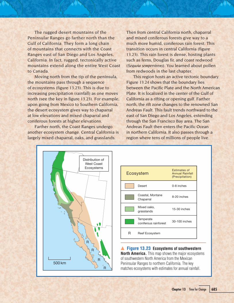
Chapter 13 Time for Change 685
The rugged desert mountains of the Peninsular Ranges go farther north than the Gulf of California. They form a long chain of mountains that connects with the Coast Ranges east of San Diego and Los Angeles, California. In fact, rugged, tectonically active mountains extend along the entire West Coast to Canada. Moving north from the tip of the peninsula, the mountains pass through a sequence of ecosystems (figure 13.23). This is due to increasing precipitation (rainfall) as one moves north (see the key in figure 13.23). For example, upon going from Mexico to Southern California, the desert ecosystem gives way to chaparral at low elevations and mixed chaparral and coniferous forests at higher elevations. Farther north, the Coast Ranges undergo another ecosystem change. Central California is largely mixed chaparral, oaks, and grasslands.
Then from central California north, chaparral and mixed coniferous forests give way to a much more humid, coniferous rain forest. This transition occurs in central California (figure 13.23). This rain forest is dense, hosting plants such as ferns, Douglas fir, and coast redwood (Sequoia sempervirens). You learned about pollen from redwoods in the last chapter. This region hosts an active tectonic boundary. Figure 13.24 shows that the boundary lies between the Pacific Plate and the North American Plate. It is localized in the center of the Gulf of California as a rifting or opening gulf. Farther north, the rift zone changes to the renowned San Andreas Fault. This fault trends northward to the east of San Diego and Los Angeles, extending through the San Francisco Bay area. The San Andreas Fault then enters the Pacific Ocean in northern California. It also passes through a region where tens of millions of people live.
� Figure 13.23 Ecosystems of southwestern North America. This map shows the major ecosystems of southwestern North America from the Mexican Peninsular Ranges to northern California. The key matches ecosystems with estimates for annual rainfall.
KH56_INQSE_CH13_p643_688_final.indd · Page 685 · 1/1/07 · 3:26:16 PMKH56_INQSE_CH13_p643_688_final.indd · Page 685 · 1/1/07 · 3:26:16 PM

686 Unit 3 Moving Matter
Recall the steps in the explain activity that reversed the motion for North and South America and closed the Atlantic Ocean. This was like “playing the movie backward” with the Atlantic Ocean.
b. Use your handout Tectonic Map of PAC and NAM to sketch the coastline of the Mexican Peninsular Ranges at intervals of about 5 and 10 Mya.
Due to a history of big earthquakes, the San Andreas Fault is watched closely. Current work shows that the Pacific Plate is sliding to the northwest at about 50 mm/yr. This is not fast if the sliding is steady. The risk for massive earthquakes arises when the fault locks up. The result can be sudden, massive lurches along the fault every 100–200 years. Events like this probably caused the great 1906 San Francisco earthquake and even many other large earthquakes along the fault in the past 20–25 Myr.
Tectonic Changes in the Southwest, continued
� Figure 13.24 Tectonic map of the Pacific and North American plates. The region shown extends from the tip of the Mexican Peninsular Ranges to northern California. Rifting in the Gulf of California changes to the north and slips along the San Andreas Fault. The vector shows the magnitude and direction of the Pacific Plate (in millimeters per year) relative to North America. Northward movement of the Pacific Plate causes a spreading ridge (red) in bottom left.
KH56_INQSE_CH13_p643_688_final.indd · Page 686 · 1/1/07 · 3:26:22 PMKH56_INQSE_CH13_p643_688_final.indd · Page 686 · 1/1/07 · 3:26:22 PM

Chapter 13 Time for Change 687
It may help to indicate the coastline with colored pencils. For example, use orange for 5 Mya and red for 10 Mya.
c. Organize your data in a T-table that lists millions of years ago and distance (in kilometers).
d. Imagine you are a geologist. Would there have been a rich reef ecosystem extending up into the Gulf of California 10 Mya? Explain your answer.
5. Predict the geologic future for the Mexican Peninsular Ranges, the Gulf of California, and the state of California in 20 Myr. What might the geography of the shoreline look like?
a. Use the magnitude of the Pacific Plate vector to determine how far it will travel relative to North America in 20 Myr (20 � 106 years).
For full credit, you must show all your work. You might also add this row to your T-table from Step 4c.
b. Use the direction of the Pacific Plate vector to show how far it will go along the San Andreas Fault in 20 Myr.
Before you do this step, try sketching the progress of the Mexican Peninsular Ranges 10 Myr into the future.
c. Identify the part of the Pacific Plate that moves north. Use a pair of scissors to cut it out of your Tectonic Map of PAC and NAM handout. Place small pieces of tape to show the parts of the Pacific Plate in their future positions. Use the scale on the map to determine the size of each piece of tape.
d. Predict what will happen to the size of the Gulf of California. List evidence to support your ideas.
e. Draw a star on your diagram to show the position of Los Angeles in 20 Myr.
If you wish, draw stars in increments of 5 Myr.
6. Predict the types of ecosystem in different sections of the Mexican Peninsular Ranges in about 20 Myr. Refer to the succession of ecosystems up the Pacific coast in figure 13.23.
It is OK to predict, but only use data from the activity as evidence to support your speculation.
a. Add neat labels to your diagram from Step 5c to indicate the type of ecosystems.
Colored pencils and a key will best illustrate your predicted distribution of ecosystems along the west coast in 20 Myr.
KH56_INQSE_CH13_p643_688_final.indd · Page 687 · 1/1/07 · 3:26:30 PMKH56_INQSE_CH13_p643_688_final.indd · Page 687 · 1/1/07 · 3:26:30 PM

688 Unit 3 Moving Matter
b. Go to the farthest, northwestern edge of the Pacific Plate in figure 13.9. This is in Siberia and Japan. What geologic process is occurring there to allow 20 Myr of slip along the San Andreas Fault?
7. Obtain from your teacher your team’s response to Step 2 about whether California will sink into the ocean during the Big One. With your teammates, critically evaluate the answers that you gave for Step 2.
Critically evaluating an issue means to give real evidence and documentation for your position. If your position is the same, you review this position, giving any new supporting evidence. If your position has changed, you outline the new position, giving evidence for your revisions.
8. Turn in all of the following to your teacher:• Initial ideas and evidence (Step 2b)• The sketch and answers for Steps 4b–d• The sketch and notes from Steps 5 and 6• The critical evaluation from Step 7
KH56_INQSE_CH13_p643_688_final.indd · Page 688 · 1/1/07 · 3:26:31 PMKH56_INQSE_CH13_p643_688_final.indd · Page 688 · 1/1/07 · 3:26:31 PM