kinney county gcd management plan - twdb.texas.gov · 1 kinney county groundwater conservation...
TRANSCRIPT

Kinney County Groundwater Conservation District
Groundwater Management Plan - 2013
Approved Plan
May 29, 2013


1
Kinney County Groundwater Conservation District
Groundwater Management Plan - 2013
TableofContents1.0 District Mission ................................................................................................................................. 4
2.0 Purpose of Management Plan ........................................................................................................... 4
3.0 District Information .......................................................................................................................... 5
3.1 District Creation ............................................................................................................................ 5
3.2 Location and Geographical Information ....................................................................................... 5
3.3 Authority / Regulatory Framework ............................................................................................... 5
3.4 Groundwater Resources of Kinney County .................................................................................. 5
3.4.1 KCGCD Management Zone – Upper Cretaceous Zone ........................................................ 6
3.4.2 KCGCD Management Zone - Edwards Zone ...................................................................... 6
3.4.3 KCGCD Management Zone – Trinity Zone ......................................................................... 7
4.0 Technical Information Required by Texas Administrative Code ..................................................... 9
4.1 Modeled Available Groundwater .................................................................................................. 9
4.1.2 GMA 7 Portion of Kinney County ........................................................................................ 9
4.1.3 GMA 10 Portion of Kinney County ...................................................................................... 9
4.2 Amount of Groundwater Being Used Within District on an Annual Basis ................................ 10
4.3 Annual Amount of Recharge from Precipitation ........................................................................ 10
4.4 Annual Volume of Water That Discharges to Springs and Surface Water Bodies ..................... 10
4.5 Annual Volume of Flow into the District, out of the District, and between Aquifers ................ 10
4.6 Estimated Surface Water Supply within the District .................................................................. 10
4.7 Projected Total Demand for Water within District ..................................................................... 10
4.8 Water Supply Needs.................................................................................................................... 11
4.9 Water Management Strategies .................................................................................................... 11
4.10 How the District will Manage Groundwater Supplies ................................................................ 11
4.11 Actions, Procedures, Performance, and Avoidance .................................................................... 12
4.12 Evidence that the Plan was Adopted after Notice and Hearing .................................................. 13
4.13 Evidence that District Coordinated with Regional Surface Water Management Entities Following Notice and Hearing ................................................................................................................ 13
4.14 Site-Specific Information ............................................................................................................ 13

2
5.0 Management Goals ......................................................................................................................... 14
5.1 Providing the most efficient use of groundwater ........................................................................ 14
5.1.1 Groundwater and Stream Flow Monitoring ........................................................................ 14
5.2 Controlling and preventing waste of groundwater ...................................................................... 14
5.2.1 Elimination of Wasteful Practices Using Groundwater ...................................................... 14
5.3 Controlling and preventing subsidence ....................................................................................... 14
5.4 Addressing conjunctive surface water management issues......................................................... 14
5.4.1 Regional Planning ............................................................................................................... 14
5.5 Addressing natural resource issues that impact the use and availability of groundwater and which are impacted by the use of groundwater ....................................................................................... 15
5.5.1 Communication with Governmental Agencies (USGS) Water Balance Studies ................ 15
5.5.2 Communication with Governmental Agencies (USGS) Monitoring WBS......................... 15
5.5.3 Communication With Governmental Agencies (Edwards Aquifer Authority) ................... 15
5.6 Addressing drought conditions ................................................................................................... 16
5.7 Addressing conservation, recharge enhancement, rainwater harvesting, precipitation enhancement, and brush control where appropriate and cost effective ................................................... 16
5.7.1 Public Water Conservation Articles .................................................................................... 16
5.7.2 Recharge Enhancement ....................................................................................................... 16
5.7.3 Rainwater Harvesting .......................................................................................................... 16
5.7.4 Precipitation Enhancement ................................................................................................. 16
5.7.5 Brush Management ............................................................................................................. 16
5.8 Addressing the desired future conditions .................................................................................... 17
5.8.1 GMA 7 – Las Moras Spring ................................................................................................ 17
5.8.2 GMA 10 – Well 70-38-902 ................................................................................................. 20
Appendix A – Draft GAM Task 10-027 (revised)
Appendix B – GAM Run 10-043 MAG (Version 2): Modeled Available Groundwater for the Edwards-Trinity (Plateau), Trinity, and Pecos Valley Aquifers in Groundwater Management Area 7
Appendix C – GAM Run 12-002 MAG: Modeled Available Groundwater for the Edwards (Balcones Fault Zone) Aquifer in Groundwater Management Area 10 for Kinney County
Appendix D – Estimated Historical Use and 2012 State Water Plan Datasets: Kinney County Groundwater Conservation District

3
Appendix E – GAM Run 12-014: Kinney County Groundwater Conservation District Management Plan
Appendix F – Rules of the Kinney County Groundwater Conservation District
Appendix G – Evidence of Notice and Hearing
Appendix H – Coordination with Surface Water Entities


4
1.0 DistrictMission The mission of the Kinney County Groundwater Conservation District is to develop, promote and implement water conservation and management strategies to conserve, preserve, and protect the groundwater supplies of the District, to protect and enhance recharge, prevent waste and pollution, and to promote efficient and beneficial use of groundwater within the District. The District seeks to protect the rights of owners of water rights as defined in Texas Water Code, Chapter 36 (36.002) within the District from impairment of their groundwater quality and quantity from within the District and to guard against same from outside the District by all means available, pursuant to the power and duties granted under Chapter 36, Subchapter “D” of the Texas Water Code. The District desires to manage the production and quality of groundwater within the District on a sustainable basis that allows the capture of water flowing through the county without jeopardizing the availability of water to the county during extended periods of low rainfall or unduly increasing the frequency of the natural cycles for springs and intermittent streams going dry.
2.0 PurposeofManagementPlan The Plan is developed to provide general guidelines for the development of the District rules and implementation of policies to support the District’s mission. The purpose of this Management Plan is to provide guidance to the District for: A. Managing the Production of Groundwater in the District
1. on a sustainable basis; 2. for beneficial use; 3. that allows the capture of water flowing through the county; 4. without jeopardizing the availability of water to the county during extended periods of
low rainfall; and 5. without unduly increasing the frequency of the natural cycles of springs and intermittent
streams going dry. B. Resolving Conflicts of Groundwater Use Between the Various Interests Seeking To Put This
Essential Natural and Renewable Resource To Beneficial Use

5
3.0 DistrictInformation
3.1 DistrictCreation In 2001, the Texas Legislature authorized the creation of the District during the 77th Regular Session through House Bill 3243 (Act of May 25, 2001, 77th Leg., R.S. ch. 1344, 2001 Tex. Gen. Laws 3329). The voters of Kinney County confirmed the creation of the District on January 12, 2002 with 87 percent of the voters casting favorable ballots.
3.2 LocationandGeographicalInformation The District is located in Kinney County, Texas. The boundaries of the District are the same boundaries that are used by Kinney County. Kinney County is in southwestern Texas and is bounded on the north by Edwards County, on the east by Uvalde County, on the south by Maverick County, and on the west by Val Verde County and Mexico. Kinney County has an area of 891,240 acres (1,391 square miles). Brackettville is the county seat and the largest town in the county.
3.3 Authority/RegulatoryFramework In the preparation of this Management Plan, the District has followed all procedures and satisfied all requirements mandated by Chapter 36 of the Texas Water Code and Chapter 356 of the Texas Water Development Board’s (TWDB) rules contained in Title 31 of the Texas Administrative Code. The District exercises the powers that it was granted and authorized to use by and through the special and general laws that govern it, including Chapter 36, as amended, Texas Water Code. The District will collaborate with surrounding counties, Mexico and other groundwater conservation districts, groundwater management areas, and regional planning areas.
The 75th
Texas Legislature in 1997 enacted Senate Bill 1 (SB 1, Act of June 2, 1997, 75th Leg. R.S., ch. 1010, 1997 Tex. Gen.Laws 3610). SB 1 established a comprehensive statewide water planning process, and contained provisions which required groundwater conservation districts to formulate management plans to identify the water supply resources and water demands that will shape the decisions of each district. The management plans for the groundwater conservation districts also include the management goals that each district would establish to manage and conserve the groundwater resources within their boundaries.
3.4 GroundwaterResourcesofKinneyCounty Currently the District works with three management zones as discussed below. These zones will be used for reference. The Kinney County Groundwater Conservation District Board reserves the right to revise boundaries of these zones as further information and/or scientific data dictate

6
changes. Boundaries of these zones are based on the recently completed groundwater flow model of the Kinney County area by the Texas Water Development Board, which can be found at:
http://www.twdb.state.tx.us/groundwater/models/alt/knny/knny.asp
3.4.1 KCGCDManagementZone–UpperCretaceousZone The Upper Cretaceous zone covers the southern portion of Kinney County, and corresponds to Layer 2 of the TWDB model as shown in Figure 1. Formations with this zone include Austin Chalk and Buda Limestone. The total thickness of these rock units is well over 1000 feet. There are several large capacity wells that have been used for irrigation. This is usually called the “bad water zone” because most of the wells have concentrations of total dissolved solids, especially sulfates, which make the water suitable for only limited uses. This water is usually below state drinking water standards. This area does recharge the groundwater so there is a need for more careful study of the groundwater environment here because a freshwater spring issues at the northwest corner of the Anacacho escarpment of the east Elm Creek.
Figure 1. Upper Cretaceous Zone
3.4.2 KCGCDManagementZone‐EdwardsZone The Edwards zone covers nearly all of Kinney County, and corresponds to Layer 3 of the TWDB model as shown in Figure 2. The zone is composed predominantly of limestone formed during the early Cretaceous Period. In Kinney County, the Edwards formation consists of the Devils River

7
Limestone or the Salmon Peak, McKnight and West Nueces Limestone with a thickness of as much as 1,000 feet. Recharge occurs primarily by the downward percolation of surface water from streams draining off the Edwards Plateau to the north and west and by direct infiltration of precipitation on the outcrop. Groundwater is also discharged artificially from pumping wells. Water levels do require monitoring for fluctuations. The chemical quality of groundwater in the zone is typically fresh, although hard, with dissolved-solids concentrations averaging less than 500 mg/l.
Figure 2. Edwards Zone
3.4.3 KCGCDManagementZone–TrinityZone The Trinity zone covers nearly all of Kinney County, and corresponds to Layer 4 of the TWDB model as shown in Figure 3. The Trinity zone consists of sediments of Lower Cretaceous age Trinity Group. The Glen Rose Limestone is the primary unit in the Trinity group in the southern part of the plateau. Springs issue from the headwaters for several eastward and southerly flowing rivers. Artesian conditions may exist in the Trinity zone. Reported well yields commonly range from less than 50 gallons per minute (gpm) to more than 1,000 gpm. Usable quality water (containing less than 3,000 mg/l dissolved solids) in the Trinity zone occurs to depths of up to about 3,000 feet. The water is typically hard and may vary widely in concentrations of dissolved solids made up mostly of calcium and bicarbonate. The salinity of the groundwater in the Trinity zone tends to increase toward the southwest. Water levels have generally fluctuated with seasonal precipitation. Water quality from the Trinity zone is acceptable

8
for most municipal and industrial purposes; however, excess concentrations of certain constituents in many places exceed drinking-water standards for municipal supplies. Excess levels of constituents are naturally occurring.
Figure 3. Trinity Zone

9
4.0 TechnicalInformationRequiredbyTexasAdministrativeCode The information in this section is provided pursuant to statutes and rules as summarized in the TWDB Groundwater Conservation District Management Plan Checklist, effective December 6, 2012. The information is organized according to the order in the checklist.
4.1 ModeledAvailableGroundwater Texas Water Code § 36.001 defines modeled available groundwater as “the amount of water that the executive administrator determines may be produced on an average annual basis to achieve a desired future condition established under Section 36.108”. Kinney County Groundwater Conservation District is within the boundaries of two Groundwater Management Areas: GMA 7 and GMA 10. The presentation and discussion of the modeled available groundwater for Kinney County for the GMA 7 portion of Kinney County and the GMA 10 portion of Kinney County are presented separately below.
4.1.2 GMA7PortionofKinneyCounty GMA 7 adopted a desired future condition for Kinney County on July 29, 2010:
In Kinney County, that drawdown which is consistent with maintaining, at Las Moras Springs, an annual average flow of 23.9 [cubic feet per second] and a median flow of 24.4 [cubic feet per second] based on Scenario 3 of the Texas Water Development Board’s flow model presented on July 27, 2010.
The desired future condition was adopted after considering a set of alternative model simulations. Scenario 3 of that set of simulations was the basis of the adopted desired future conditions, as referenced in the resolution of GMA 7. Scenario 3 (and other alternative runs) is documented in TWDB Draft GAM Task 10-027 (Revised), dated February 9, 2011, which is attached as Appendix A to this plan. The modeled available groundwater was calculated by the Texas Water Development Board, and was provided in GAM Run 10-043 MAG (Version 2), dated November 12, 2012, which is attached as Appendix B to this plan. The modeled available groundwater for the GMA 7 portion of Kinney County is 70,338 acre-feet per year.
4.1.3 GMA10PortionofKinneyCounty
GMA 10 adopted a desired future condition for Kinney County on August 4, 2010:
The district members of Groundwater Management Area 10 adopt the scenario for Kinney County that the DFC [Desired Future Condition] shall be that the water

10
level in well number 70-38-902 shall not fall below 1184 feet MSL [Mean Sea Level]
The modeled available groundwater was calculated by the Texas Water Development Board and was provided in GAM Run 12-002 MAG, dated July 24, 2012, which is attached as Appendix C to this plan. The modeled available groundwater for the GMA 10 portion of Kinney County is 6,321 acre-feet per year.
4.2 AmountofGroundwaterBeingUsedWithinDistrictonanAnnualBasis Please refer to Appendix D: Estimated Historical Use and 2012 State Water Plan Datasets, Kinney County Groundwater Conservation District.
4.3 AnnualAmountofRechargefromPrecipitation Please refer to Appendix E: GAM Run 12-014, Kinney County Groundwater Conservation District Management Plan.
4.4 AnnualVolumeofWaterThatDischargestoSpringsandSurfaceWaterBodies
Please refer to Appendix E: GAM Run 12-014, Kinney County Groundwater Conservation District Management Plan.
4.5 AnnualVolumeofFlowintotheDistrict,outoftheDistrict,andbetweenAquifers
Please refer to Appendix E: GAM Run 12-014, Kinney County Groundwater Conservation District Management Plan.
4.6 EstimatedSurfaceWaterSupplywithintheDistrict Please refer to Appendix D: Estimated Historical Use and 2012 State Water Plan Datasets, Kinney County Groundwater Conservation District.
4.7 ProjectedTotalDemandforWaterwithinDistrict Please refer to Appendix D: Estimated Historical Use and 2012 State Water Plan Datasets, Kinney County Groundwater Conservation District.

11
4.8 WaterSupplyNeeds Please refer to Appendix D: Estimated Historical Use and 2012 State Water Plan Datasets, Kinney County Groundwater Conservation District.
4.9 WaterManagementStrategies Please refer to Appendix D: Estimated Historical Use and 2012 State Water Plan Datasets, Kinney County Groundwater Conservation District.
4.10 HowtheDistrictwillManageGroundwaterSupplies The District will manage the production of groundwater from the Edwards-Trinity Management Zone and the Edwards (BFZ) Management Zone, and the local Austin Chalk Management Zone and Uvalde gravel within the District in a sustainable manner. Monitor well(s) or trigger well(s) will be developed in the existing Management Zones. As future scientific research indicates, the District may be sub-divided into additional Management Zones, and within each of these additional Management Zones, monitor well(s) or trigger well(s) will be developed. Each Management Zone within the District will have a series of triggers or drought stage levels as specified in the Critical Period Management Plan. The District may develop and implement groundwater well spacing and production regulations that are specific to water availability, the geographic area and site specific to the well and the wells’ behavior in the groundwater environment. Where appropriate and necessary to minimize interference, the District shall cause production monitor wells to be installed along the perimeter of a permittee’s property and adjacent to a well field to monitor and regulate the cone of influence within the boundaries of a production unit. Among the regulatory tools granted to districts, the Legislature empowered districts to protect current users of groundwater, which are those individuals or entities currently invested in or using groundwater resources within the District for a beneficial purpose. The District is also empowered to protect Historic and Existing permit users, which are those individuals or entities that used groundwater beneficially in the past. Most of the groundwater used in Kinney County has been applied to agricultural irrigation, domestic and livestock purposes. The District strives to protect such purposes to the extent practicable under the goals and objectives of this Management Plan. This shall be done without discriminating against any other lawful and beneficial purpose. A cooperative agreement may be between governmental entities pursuant to Texas Governmental Code to accomplish mutual objectives or may be between the District and any well owner to provide a vehicle for gathering well-site specific information on well water levels and rainfall histories. These cooperative agreements should facilitate the District providing technical support on the status of the groundwater availability for each well.

12
The District, through this Management Plan and its rules, will attempt to manage groundwater withdrawals in the District at a level that will not cause depletion of these groundwater management zones in the future. The District should allow as much groundwater to be produced as possible for beneficial purposes while preventing the overproduction and mining of the groundwater resources of Kinney County. In an effort to protect the springs, intermittent streams and long-term productivity of these groundwater resources, the District shall engage in scientific research and data collection in order to establish the amount of groundwater that can be produced from within the District. Current amounts used are based on TWDB and Region J data. The District’s greatest challenge is determining, through scientific study, the actual groundwater resources of Kinney County. Proper science requires a diligent effort by the District and other interested parties to gather appropriate information and apply that information responsibly. As data becomes available, this Plan and its associated rules should be updated to reflect this additional information. Care should be exercised not to overestimate or underestimate the amount of groundwater available on incomplete, poorly applied science or speculative data. The District has created a tiered process that categorizes groundwater use and allocates available groundwater in accordance with District rules. The tiered process prioritizes groundwater use for the protection of urban populations within the District, exempt well owners, existing permit users and historic permit users, as the District allocates the remaining available groundwater through the concept of “proportionate reduction” and “zone management processes” as defined in the District’s rules. The District will protect all permit users by establishing rules for permitting wells, transfer of water permits from one entity or individual to another, and the scientific data requirements for new or increased use. In conversion of permits for export the amount permitted shall not exceed the Maximum Historic Use as demonstrated by the applicant or suggested by agreements with other existing permittees. The General Manager of the District will prepare and submit an annual report ("Annual Report") to the Board of the District. The Annual Report will include an update on the District's performance in regards to achieving management goals and objectives. The General Manager of the District will present the Annual Report within ninety (90) days following the completion of the District's fiscal year audit, beginning with the fiscal year that starts October 1, 2008. Upon adoption, the Board will maintain a copy of the Annual Report on file, for public inspection, at the District's offices.
4.11 Actions,Procedures,Performance,andAvoidance The District will implement the goals and provisions of this Management Plan and will utilize the objectives of this Management Plan as a guideline in its decision-making to be consistent with the provisions of this plan. The District has adopted rules, in accordance with Chapter 36 of the Texas Water Code, which implement the Management Plan. The current version of the rules is dated September 10, 2010, 2009, and is attached as Appendix F. All rules will be followed and enforced. The District will amend the District rules as necessary to comply with changes to Chapter 36 of the Texas Water
13
Code and to insure the best management of the groundwater within the District. The development and enforcement of the rules of the District will be based on the best scientific and technical evidence available to the District. The District will encourage cooperation and coordination in the implementation of this plan. All operations and activities of the District will be performed in a manner that best encourages cooperation with the appropriate state, regional or local water entity. The Board meetings of the District will be noticed and conducted in accordance with the Texas Open Meetings Law. All official documents, reports, records and minutes of the District will be available for public inspection and copying in accordance with the Texas Public Information Act. Annually, the District shall appoint a Groundwater Management Plan Committee chaired by a Board Director and conduct a review of (a) science and knowledge of the water resources available for the District’s regulation, permitting and conservation and (b) make recommendations for improved management of the resources over which the District has jurisdiction. The Committee’s appointment, report and action by the Board in response to such recommendations shall each be noticed in a local publication distributed within Kinney County.
4.12 EvidencethatthePlanwasAdoptedafterNoticeandHearing Please refer to Appendix G (to be added later).
4.13 Evidence that District Coordinated with Regional Surface WaterManagementEntitiesFollowingNoticeandHearing
Please refer to Appendix H (to be added later).
4.14 Site‐SpecificInformation Not Applicable

14
5.0 ManagementGoals
5.1 Providingthemostefficientuseofgroundwater
5.1.1 GroundwaterandStreamFlowMonitoring Objective: Establish a monitoring network to measure groundwater quantity in a minimum of one (1) well per year in the major aquifers of the District and stream flow volume in Las Moras Creek and Pinto Creek. Performance Standard: The District will monitor the water level in at least one well per year in the major aquifers of the District and stream flow volume in Las Moras Creek and Pinto Creek. A report on the data collected through this monitoring network will be included in the Annual Report.
5.2 Controllingandpreventingwasteofgroundwater
5.2.1 EliminationofWastefulPracticesUsingGroundwater Objective: Increase public awareness within the District regarding the need for water conservation, and encourage the elimination of wasteful practices regarding groundwater within the boundaries of the District. Performance Standard – Submit an article annually regarding the elimination of wasteful practices and/or conservation of groundwater to a local publication for distribution in Kinney County and a copy kept in the District office for a period of three (3) years.
5.3 Controllingandpreventingsubsidence Not applicable to the Kinney County Groundwater Conservation District
5.4 Addressingconjunctivesurfacewatermanagementissues
5.4.1 RegionalPlanning Objective: By attending Region J meetings, there is the opportunity to participate in the discussions, planning and education concerning the interrelationship of the groundwater and surface water interface. The Board President or his appointed representative will attend 75% of Region J meetings annually.
15
Performance Standard: The minutes for all attended meetings of Region J will be maintained in the District for a period of three (3) years from their accepted date. A report of all attended meetings will be given to the Board at the regular meeting.
5.5 Addressingnaturalresourceissuesthatimpacttheuseandavailabilityofgroundwaterandwhichareimpactedbytheuseofgroundwater
5.5.1 CommunicationwithGovernmentalAgencies(USGS)WaterBalanceStudies Objective: The District will support or participate in water balance studies with the United States Geological Survey (USGS) by investigating sources of funding for the continuation of the research. Performance Standard: The District will annually document all attempts to secure funding and all sources of funding found and maintain these records in the District office for a period of three (3) years. The District will include a report on the funding activity in the Annual Report and/or provided to the District Board annually.
5.5.2 CommunicationwithGovernmentalAgencies(USGS)MonitoringWBS Objective: The District will monitor the work of the United States Geological Survey (USGS) in the “Western Edwards Water Balance Study” while it is active or until the study is complete. Performance Standard: The District will annually document the progress of the USGS study and any communication received from the USGS about the study. This documentation will be maintained in the District office. A report on the progress of the study will be included in the Annual Report and/or provided to the District Board annually.
5.5.3 CommunicationWithGovernmentalAgencies(EdwardsAquiferAuthority) Objective: The District will monitor the work of the Edwards Aquifer Authority (EAA) in conducting groundwater dye trace studies in Kinney County until such studies are complete. Performance Standard: The District will annually maintain a file on the progress or results of the EAA research and any communications received from the EAA about the studies. This documentation will be maintained in the District office. A report on the progress or results of the dye trace studies will be included in the Annual Report and/or provided to the District Board annually.

16
5.6 Addressingdroughtconditions Objective: Once a month, the District will download the latest drought information from the National Weather Service – Climate Prediction Center website (last accessed on March 16, 2013):
http://www.cpc.ncep.noaa.gov/products/Drought Performance Standard: A report on the drought data obtained from the National Weather Service will be included in the regular monthly meeting agenda and retained in the meeting minutes kept at the District office.
5.7 Addressingconservation,rechargeenhancement,rainwaterharvesting,precipitationenhancement,andbrushcontrolwhereappropriateandcosteffective
5.7.1 PublicWaterConservationArticles Objective - Increase public awareness within the District regarding the need for water conservation. Performance Standard - Submit an article annually regarding the elimination of wasteful practices and/or conservation of groundwater to a local publication for distribution in Kinney County and a copy kept in the District office for a period of three (3) years.
5.7.2 RechargeEnhancement Goal determined to be Not Applicable for the District. Goal is not cost effective at this time.
5.7.3 RainwaterHarvesting Goal determined to be Not Applicable for the District. Goal is not cost effective at this time.
5.7.4 PrecipitationEnhancement Goal determined to be Not Applicable for the District. Goal is not cost effective at this time.
5.7.5 BrushManagement
This service is provided by NRCS in Kinney County as a function of the Federal Government. This Goal is determined to be Not Applicable for the District.

17
5.8 Addressingthedesiredfutureconditions
5.8.1 GMA7–LasMorasSpring The desired future condition for Kinney County in GMA 7 is expressed as an average spring flow and a median spring flow for Las Moras Spring based on Scenario 3 of TWDB Draft GAM Task 10-027 (Revised), dated February 9, 2011, which is attached as Appendix A to this plan. Please note that the average flow (23.9 cubic feet per second) and the median flow (24.4 cubic feet per second) were calculated based on a 56-year simulation under a constant pumping assumption. Also, it should be noted that the spring flow in the simulation is based on an end-of-year measurement. Thus, comparison of any individual measured spring flows to this average for purposes of demonstrating consistency with the desired future condition would be inappropriate. The 56-year simulation that was used as the basis of establishing the desired future condition included an assumption of varying recharge by repeating the recharge of the years 1950 to 2005. Annual rainfall was used in the model to estimate annual recharge. Thus, it is possible to plot the relationship between annual rainfall and end-of-year spring flow taken from Scenario 3 of GAM Task 10-027 (Revised) as shown in Figure 2, including a best-fit line for the data. Figure 2 also depicts estimated maximum and minimum spring flows for the range of precipitation values.
Figure 2. Annual Precipitation vs. End-of-Year Las Moras Spring Flow

18
This relationship presented in Figure 2 can be useful in interpreting end-of-year measurements of spring flow against the desired future condition. Objective – The District will assess annually the end-of-year Las Moras spring flow and annual precipitation to evaluate consistency with the desired future condition. Performance Standard – Each year, data on annual precipitation and end-of-year Las Moras spring flow will be collected. For purposes of this calculation, the precipitation used by the TWDB in the development of the groundwater model will be used:
Brackettville Del Rio AP Eagle Pass 3N LaPryor Langtry Rocksprings 1S
Average annual precipitation from these stations from 1950 to 2008 was 17.69 inches. The average of annual precipitation data (in inches) from these stations will be used to develop a “best-fit”, “low”, and “high” spring flows (in cubic feet per second) based on the following equations:
Best: Spring Flow = 1.3737 + (1.665*precip) + (-0.01681*precip^2)
Low: Spring Flow = -8.6767 + (1.67223*precip) + (-0.01314*precip^2)
High: Spring Flow = 8.0228 + (2.10967*precip) + (-0.02556*precip^2) Table 1 summarizes the calculations for selected values of precipitation. A report on the annual precipitation, measured end-of-year Las Moras spring flow, and the three estimates will be included in the Annual Report.

19
Table 1. Las Moras Spring Flow Estimated from Annual Precipitation
Annual Precipitation (in/yr)
End-of-Year Las Moras Spring Flow (cfs)
Best Low High
4 7.76 0.00 16.05
5 9.28 0.00 17.93
6 10.76 0.88 19.76
7 12.20 2.39 21.54
8 13.61 3.86 23.26
9 14.99 5.31 24.94
10 16.34 6.73 26.56
11 17.65 8.13 28.14
12 18.93 9.50 29.66
13 20.17 10.84 31.13
14 21.38 12.16 32.55
15 22.56 13.45 33.92
16 23.71 14.72 35.24
17 24.82 15.95 36.50
18 25.89 17.17 37.72
19 26.93 18.35 38.88
20 27.94 19.51 39.99
21 28.92 20.65 41.06
22 29.86 21.75 42.07
23 30.77 22.84 43.03
24 31.64 23.89 43.93
25 32.49 24.92 44.79
26 33.29 25.92 45.60
27 34.07 26.90 46.35
28 34.81 27.85 47.06
29 35.51 28.77 47.71
30 36.19 29.67 48.31
31 36.83 30.54 48.86
32 37.43 31.38 49.36
33 38.00 32.20 49.81
34 38.54 32.99 50.21
35 39.05 33.76 50.56
36 39.52 34.50 50.85
37 39.96 35.21 51.09
38 40.36 35.90 51.29

20
5.8.2 GMA 10 – Well 70-38-902 The desired future condition in the GMA 10 portion of Kinney County is that the groundwater elevation in Well 70-38-902 shall not fall below 1,184 feet MSL (Mean Sea Level). Because this condition was based on a model run that considered end-of-year groundwater elevations, data collected at the end of the year would be used for comparison purposes. Objective - The District use the groundwater elevation measured in Well 70-38-902 by the Edwards Aquifer Authority that is collected in either December or January each year to evaluate consistency with the desired future condition. Note that when converting a depth-to-water measurement in the well to a groundwater elevation, the measuring point elevation is 1,381.042 ft MSL. Performance Standard – The measured groundwater elevation in Well 70-38-902 taken at the end of the year and the desired future condition minimum elevation will be included in the Annual Report.


Appendix A
Draft GAM Task 10-027 (revised)

Draft GAM Task 10-027 (revised) by William R. Hutchison, Ph.D, P.E., P.G.
Texas Water Development Board Groundwater Resources Division (512) 463-5067 February 9, 2011
This document is released for the purpose of interim review under the authority of William R. Hutchison, P.E. 96287, P.G. 286 on February 9, 2011

Draft GAM Task 10-027 (revised) February 9, 2011 Page 2 of 8
EXECUTIVE SUMMARY This GAM Task summarizes the results of seven pumping scenarios using the recently completed groundwater flow model of the Kinney County area. The seven pumping scenarios represent pumping that is higher and lower than historic pumping in order to evaluate changes in spring flow in Las Moras Spring and estimate minimum groundwater elevation in the monitor well that is used by the Kinney County Groundwater Conservation District. The spring flow and minimum groundwater elevation have been adopted by the Kinney County Groundwater Conservation District as their desired future conditions of the aquifer. Based on this analysis, average spring flow in Las Moras spring will be 23.9 cubic feet per second and median spring flow in Las Moras Spring will be 24.4 cubic feet per second if pumping is about 77,000 acre-feet per year in Kinney County. Minimum groundwater elevation in the monitoring well will be 1,184 feet above mean sea level under this scenario. The minimum groundwater elevation has been revised from an earlier version of the Draft GAM Task report based on input from the Kinney County Groundwater Conservation District regarding the land surface elevation of the monitoring well used in this analysis. ORIGIN OF TASK: The Kinney County Groundwater District requested assistance in developing desired future conditions. As a result of this request, TWDB staff developed a groundwater flow model of all the aquifers in Kinney County and surrounding areas. This model is documented in Hutchison and others (2011). This task report summarizes the results of seven scenarios that were presented at the Kinney County Groundwater Conservation District Board meeting of July 27, 2010. DESCRIPTION OF TASK: Based on the results of the calibration of the groundwater flow model of Kinney County, historic groundwater pumping from 1950 to 2005 has ranged from about 51,000 acre-feet per year to about 77,000 acre-feet per year (Hutchison and others 2011). In general, pumping increases result in reduced spring flow, and reduced pumping result in increased spring flow. The objective of the simulations run for this task was to quantify the change in spring flow under various scenarios of constant pumping. The information from these simulations has been used by the Kinney County Groundwater Conservation District in establishing the desired future conditions of the aquifer as part of the Joint Planning Process in Groundwater Management Areas 7 and 10. In order to facilitate comparison with historic spring flows, all simulations were run with the recharge and river conditions equivalent to the historic period (1950 to 2005).

Draft GAM Task 10-027 (revised) February 9, 2011 Page 3 of 8
METHODS: Seven pumping scenarios were developed for this task, each with constant pumping. The base case assumed 77,000 acre-feet per year (AF/yr) of pumping, which is equivalent to the highest year of pumping based on the calibrated model for the period 1950 to 2005. Two scenarios included reduced pumping and four scenarios included increased pumping as follows:
Scenario Kinney County Pumping
(AF/yr) 1 38,000 2 57,000 3 77,000 4 96,000 5 115,000 6 134,000 7 153,000
The scenarios consisted of running the model for 56 years, using recharge and river conditions from 1950 to 2005 in order to facilitate comparison with the historic spring flows. PARAMETERS AND ASSUMPTIONS:
• The recently developed groundwater flow model of the Kinney County area (Hutchison and others, 2011) was used for these simulations.
• The model has four layers: layer 1 represents the Carrizo-Wilcox and associated
aquifers, layer 2 represents the upper Cretaceous formations that yield groundwater, layer 3 represents the Edwards (Balcones Fault Zone) Aquifer and the Edwards Group of the Edward-Trinity (Plateau) Aquifer, and layer 4 represents the Trinity Aquifer.
• As further detailed in the model report (Hutchison and others, 2011), model
calibration statistics for the entire model domain for groundwater elevation and spring flow are summarized below. Note that groundwater elevation data are expressed in feet above mean sea level (ft MSL), and spring flows are expressed in cubic feet per second (cfs):

Draft GAM Task 10-027 (revised) February 9, 2011 Page 4 of 8
Statistic Groundwater
Elevation Spring Flow
Number of Measurements 1,878 432 Average Residual 4.5 ft -1.2 cfs Standard Deviation 58 ft 10 cfs Range of Measurements 1,581 ft 223 cfs Standard Deviation divided by Range 0.04 0.04
• Seven different pumping scenarios were used as described above
• Each simulation consisted of 57 stress periods. All model input files were
identical to the calibration period in each scenario except for the pumping file, as noted above.
• The model was run with MODFLOW-2000 (Harbaugh and others, 2000).
RESULTS: Spring Flow The results of the simulation include estimating spring flow changes under alternative pumping scenarios. A summary of the results expressed as average spring flow for the three major springs in Kinney County (Las Moras, Mud, and Pinto) as a function of pumping in Kinney County are presented in Figure 1.
Figure 1. Kinney County Pumping versus Spring Flow for Seven Pumping Scenarios.

Draft GAM Task 10-027 (revised) February 9, 2011 Page 5 of 8
Note that as a result of input received from the Kinney County Groundwater Conservation District Board of Directors, Las Moras is the only spring for which a desired future condition will be set due to monitoring constraints. The frequency of various flows in Las Moras spring that are a result of changes in recharge conditions are presented in Table 1.
Because the average spring flow and median spring flow of Scenario 3 were adopted as the desired future condition for Kinney County, a graphical summary of Scenario 3 for Las Moras Spring is presented in Figure 2. Note that the average flow and the median flow fall into the group that would occur about 9 percent of the time (20 to 25 cfs). A spring flow between 15 and 20 cfs (slightly below the adopted desired future condition) would occur 18 percent of the time, and flow between 25 and 30 cfs (slightly above the adopted desired future condition) would occur about 16 percent of the time. Thus, Las Moras spring flow would be between 15 and 30 cfs about 43 percent of the time. Note that because the model was run on annual stress periods, these spring flows are representative of end-of-the calendar year conditions. Thus, for comparative purposes, flows collected in December and January should be used to track with the desired future condition.

Draft GAM Task 10-027 (revised) February 9, 2011 Page 6 of 8
Figure 2. Las Moras Spring Flow Frequency for Scenario 3. Groundwater Elevations Groundwater elevation changes due to pumping were evaluated for the monitoring well used by the Kinney County Groundwater Conservation District (Well No. 70-38-902). This well was constructed in 1973 by the Texas Water Development Board. The earlier version of this Draft GAM Task report calculated groundwater elevations using a measuring point elevation of 1,373 ft MSL. However, during review of this document, the Kinney County Groundwater Conservation District informed the Texas Water Development Board in an email dated February 8, 2011, that the measuring point elevation is 1,381.042 ft MSL. Consequently, the hydrograph of measured groundwater elevations presented in Figure 3 have been revised. Note that the minimum groundwater elevation is 1,186, which was measured in January of 1991. The monitoring well has a limited record of data as compared to the calibration period of the model. Moreover, some of the highest levels of groundwater pumping in Kinney County predate the existence of the monitoring well.

Draft GAM Task 10-027 (revised) February 9, 2011 Page 7 of 8
Figure 3. Groundwater elevation measurements in Well 70-38-902.
Because the Kinney County Groundwater Conservation District Board of Directors has adopted a minimum groundwater elevation in this well (1,184 ft MSL) as desired future condition for the Groundwater Management Area 10 portion of Kinney County, an analysis of simulated groundwater levels at the site of this well was completed. Figure 4 presents a comparison of the simulated groundwater elevation estimates with measured groundwater elevations.
Figure 4. Comparison of simulated groundwater elevations and measured groundwater elevations from winter months.
Draft GAM Task 10-027 (revised) February 9, 2011 Page 8 of 8
Note that the general trend is that the simulated groundwater elevations are slightly higher than the measured groundwater elevations. At the end of 1990, the simulated groundwater elevation was estimated to be 1,196 ft MSL, and is comparable to the measured value in January 1991 of 1,186 ft MSL. Note that from 1950 to 2005, there were five years where the simulated groundwater elevation was lower than that simulated in 1990. These estimates are as follows:
• 1957 (4 feet lower than 1990), • 1953 and 1964 (3 feet lower than 1990), • 1981 (2 feet lower than 1990), and • 1954 (1 foot lower than 1990).
The Kinney County Groundwater Conservation District has adopted desired future conditions that are consistent with Scenario 3, and established a minimum groundwater elevation in Well 70-38-902 of 1,184 ft MSL in the Kinney County portion of Groundwater Management Area 10. Given the nature of the desired future condition, the actual data collected at the well, and the accuracy of the model, it is concluded that the desired future condition expressed by the Kinney County Groundwater Conservation District (minimum groundwater elevation for Well 70-38-902 of 1,184 ft MSL) is consistent with Scenario 3. REFERENCES:
Harbaugh, A.W., Banta, E.R., Hill, M.C., and McDonald, M.G., 2000, MODFLOW-2000, The U.S. Geological Survey modular ground-water model-user guide to modularization concepts and the ground-water flow process: U.S. Geological Survey Open-File Report 00-92, 121 p.
Hutchison, William R., Shi, Jerry, and Jigmond, Marius, 2011. Groundwater Flow Model
of the Kinney County Area. Texas Water Development Board Unpublished Report.


Appendix B
GAM Run 10-043 MAG (Version 2): Modeled Available Groundwater for the Edwards-Trinity (Plateau), Trinity, and Pecos
Valley Aquifers in Groundwater Management Area 7


This page is intentionally blank.

GAM RUN 10-043 MAG (VERSION 2): MODELED AVAILABLE GROUNDWATER FOR THE EDWARDS-TRINITY (PLATEAU), TRINITY, AND
PECOS VALLEY AQUIFERS IN GROUNDWATER MANAGEMENT AREA 7
by Jerry Shi, Ph.D., P.G. Texas Water Development Board Groundwater Resources Division
Groundwater Availability Modeling Section (512) 463-5076
November 12, 2012
EXECUTIVE SUMMARY:
The modeled available groundwater values for Groundwater Management Area 7 for the Edwards-Trinity (Plateau), Trinity, and Pecos Valley aquifers are summarized in Table 1. These values are also listed by county (Table 2), river basin (Table 3), and regional water planning area (Table 3). The modeled available groundwater values for the relevant aquifers in Groundwater Management Area 7 were initially based on Scenario 10 of GAM Run 09-035. In GAM Run 09-035, the Edwards-Trinity (Plateau), Trinity, and Pecos Valley aquifers were simulated and reported together. Though the desired future condition statement, specifying an average drawdown of 7 feet, only explicitly references the Edwards-Trinity (Plateau) Aquifer, it is the intent of the districts to also incorporate the Trinity and Pecos Valley aquifers. This was confirmed by Ms. Caroline Runge of Menard Underground Water District acting on behalf of Groundwater Management Area 7 in an e-mail to Ms. Sarah Backhouse at the Texas Water Development Board on June 6, 2012. The results here, therefore, contain information for each of these three aquifers. The modeled available groundwater from the Edwards-Trinity (Plateau), Trinity, and Pecos Valley aquifers in Groundwater Management Area 7 that achieves the requested desired future conditions is approximately 449,400 acre-feet per year from 2010 to 2060.
Earlier draft versions of this report showed modeled available groundwater for portions of the Edwards-Trinity (Plateau) Aquifer within the Lipan-Kickapoo Water Conservation District, the Lone Wolf Groundwater Conservation District, the Hickory Underground Water Conservation District No. 1, and the portion of the Trinity Aquifer within the Uvalde Underground Water Conservation District. However, Groundwater Management Area 7 declared those counties “not relevant” for joint planning purposes. Since modeled available groundwater only applies to areas with a specified desired future condition, we updated this report to depict modeled available groundwater only in counties with specified desired future conditions.

GAM Run 10-043 MAG (Version 2): Modeled Available Groundwater for the Edwards-Trinity (Plateau), Trinity, and Pecos Valley aquifers in Groundwater Management Area 7 November 12, 2012 Page 4 of 15
The modeled available groundwater for Kinney County Groundwater Conservation District previously reported in Draft GAM Run 10-043 MAG (Shi and Oliver, 2011) dated January 26, 2011, has been updated in a new model run and is presented in this report. The new model run is an update of Scenario 3 of Groundwater Availability Modeling Task 10-027, which meets the desired future conditions for the area adopted by the districts of Groundwater Management Area 7.
REQUESTOR:
Mr. Allan Lange of Lipan-Kickapoo Water Conservation District on behalf of Groundwater Management Area 7.
DESCRIPTION OF REQUEST:
In a letter dated August 13, 2010, Mr. Lange provided the Texas Water Development Board (TWDB) with the desired future conditions of the Edwards-Trinity (Plateau) Aquifer in Groundwater Management Area 7. On June 6, 2012 TWDB clarified through e-mail with Ms. Caroline Runge of Menard Underground Water District acting on behalf of Groundwater Management Area 7 that the intent of the districts within Groundwater Management Area 7 was to also incorporate the Trinity and Pecos Valley aquifers, except where explicitly stated as non-relevant in the desired future conditions of the Edwards-Trinity (Plateau) Aquifer. The desired future conditions for the aquifer[s], as described in Resolution # 07-29-10-9 and adopted July 29, 2010 by the groundwater conservation districts within Groundwater Management Area 7, are described below:
1) An average drawdown of 7 feet for the Edwards-Trinity (Plateau)[, Pecos Valley, and Trinity] aquifer[s], except for the Kinney County [Groundwater Conservation District], based on Scenario 10 of the TWDB [Groundwater Availability Model] run 09-35 which is incorporated in its entirety into this resolution; and
2) In Kinney County, that drawdown which is consistent with maintaining, at Las Moras Springs, an annual average flow of 23.9 [cubic feet per second] and a median flow of 24.4 [cubic feet per second] based on Scenario 3 of the Texas Water Development Board’s flow model presented on July 27, 2010; and
3) the Edwards-Trinity [Aquifer] is not relevant for joint planning purposes within the boundaries of the Lipan-Kickapoo [Water Conservation District], the Lone Wolf [Groundwater Conservation District], and the Hickory Underground Water Conservation District No. 1; and
4) the Trinity (Hill Country) portion of the aquifer is not relevant for joint planning purposes within the boundaries of the Uvalde [Underground Water Conservation District] in [Groundwater Management Area] 7.

GAM Run 10-043 MAG (Version 2): Modeled Available Groundwater for the Edwards-Trinity (Plateau), Trinity, and Pecos Valley aquifers in Groundwater Management Area 7 November 12, 2012 Page 5 of 15
METHODS, PARAMETERS AND ASSUMPTIONS:
The desired future condition for Kinney County was evaluated in a new model run (Shi and others, 2012). The new model run is an update of Scenario 3 of Groundwater Availability Modeling (GAM) Task 10-027 (Hutchison, 2010a). Both model runs were based on the MODFLOW-2000 model developed by the TWDB to assist with the joint planning process regarding the Kinney County Groundwater Conservation District (Hutchison and others, 2011b). In both model runs, the total pumping in Kinney County, which lies within Groundwater Management Areas 7 and 10, was maintained at approximately 77,000 acre-feet per year to achieve the desired future conditions at Las Moras Springs. Details regarding this new model run are summarized in Shi and others (2012).
The desired future condition for the remaining areas in Groundwater Management Area 7 was based on Scenario 10 of GAM Run 09-035 using a MODFLOW-2000 model developed by the TWDB (Hutchison and others, 2011a). Details regarding this scenario can be found in Hutchison (2010b). In GAM Run 09-035, the Edwards-Trinity (Plateau), Trinity, Pecos Valley, and Trinity aquifers were simulated and reported together. The desired future condition statement specifying of an average drawdown of 7 feet, which is achieved in the above simulation, only explicitly references the Edwards-Trinity (Plateau) Aquifer. By stating that the above simulation is “incorporated in its entirety” into the resolution, it is the intent of the districts to also incorporate the Trinity and Pecos Valley aquifers. The results below, therefore, contain information on the Trinity and Pecos Valley aquifers in addition to the Edwards-Trinity (Plateau) Aquifer. This interpretation has been confirmed by Ms. Caroline Runge on behalf of Groundwater Management Area 7 to Ms. Sarah Backhouse at the Texas Water Development Board.
The locations of the Edwards-Trinity (Plateau), Trinity, and Pecos Valley aquifers are shown in Figure 1.
RESULTS:
The modeled available groundwater values from aquifers in Groundwater Management Area 7 that achieve the desired future conditions is approximately 445,000 acre-feet per year for the Edwards-Trinity (Plateau) aquifer, 2,500 acre-feet per year for the Trinity Aquifer, and 1,600 acre-feet per year for the Pecos Valley Aquifer (Tables 1, 2, and 3). These tables contain the modeled available groundwater for the aquifers subdivided by county, regional water planning area, and river basin for use in the regional water planning process. These areas are shown in Figure 2.
Tables 4, 5, and 6 show the modeled available groundwater for the Edwards-Trinity (Plateau), Trinity, and Pecos Valley aquifers summarized by county, regional water planning area, and river basin, respectively, within Groundwater Management Area 7.
The modeled available groundwater for the aquifers within and outside the groundwater conservation districts in Groundwater Management Area 7 where they were determined to be relevant for the purposes of joint planning are presented in Table 7. As shown in Table 7, the modeled available groundwater within the groundwater conservation districts in Groundwater Management Area 7 is approximately 370,000 acre-feet per year from 2010 to 2060.

GAM Run 10-043 MAG (Version 2): Modeled Available Groundwater for the Edwards-Trinity (Plateau), Trinity, and Pecos Valley aquifers in Groundwater Management Area 7 November 12, 2012 Page 6 of 15
LIMITATIONS:
The groundwater model used in developing estimates of modeled available groundwater is the best available scientific tool that can be used to estimate the pumping that will achieve the desired future conditions. Although the groundwater model used in this analysis is the best available scientific tool for this purpose, it, like all models, has limitations. In reviewing the use of models in environmental regulatory decision-making, the National Research Council (2007) noted:
“Models will always be constrained by computational limitations, assumptions, and knowledge gaps. They can best be viewed as tools to help inform decisions rather than as machines to generate truth or make decisions. Scientific advances will never make it possible to build a perfect model that accounts for every aspect of reality or to prove that a given model is correct in all respects for a particular regulatory application. These characteristics make evaluation of a regulatory model more complex than solely a comparison of measurement data with model results.”
A key aspect of using the groundwater model to develop estimates of modeled available groundwater is the need to make assumptions about the location in the aquifer where future pumping will occur. As actual pumping changes in the future, it will be necessary to evaluate the amount of that pumping as well as its location in the context of the assumptions associated with this analysis. Evaluating the amount and location of future pumping is as important as evaluating the changes in groundwater levels, spring flows, and other metrics that describe the condition of the groundwater resources in the area that relate to the adopted desired future condition.
Given these limitations, users of this information are cautioned that the modeled available groundwater numbers should not be considered a definitive, permanent description of the amount of groundwater that can be pumped to meet the adopted desired future condition. Because the application of the groundwater model was designed to address regional scale questions, the results are most effective on a regional scale. Texas Water Development Board Makes no warranties or representations relating to the actual conditions of any aquifer at a particular location or at a particular time.
It is important for groundwater conservation districts to monitor future groundwater pumping as well as whether or not they are achieving their desired future conditions. Because of the limitations of the groundwater model and the assumptions in this analysis, it is important that the groundwater conservation districts work with Texas Water Development Board to refine these modeled available groundwater numbers given the reality of how the aquifer responds to the actual amount and location of pumping now and in the future.

GAM Run 10-043 MAG (Version 2): Modeled Available Groundwater for the Edwards-Trinity (Plateau), Trinity, and Pecos Valley aquifers in Groundwater Management Area 7 November 12, 2012 Page 7 of 15
REFERENCES:
Hutchison, William R., 2010a, GAM Task 10-027: Texas Water Development Board, GAM Task 10-027 Report, 7 p.
Hutchison, William R., 2010b, GAM Run 09-035 (version 2): Texas Water Development Board, GAM Run 09-035 Report, 10 p.
Hutchison, William R., Jones, Ian, and Anaya, Roberto, 2011a, Update of the Groundwater Availability Model for the Edwards-Trinity (Plateau) and Pecos Valley Aquifers of Texas, Texas Water Development Board, 59 p.
Hutchison, William R., Shi, Jerry, and Jigmond, Marius, 2011b, Groundwater Flow Model of the Kinney County Area, Texas Water Development Board, 138 p.
Shi, Jerry, Ridgeway, Cindy, and French, Larry, 2012, Draft GAM Task Report 12-002: Modeled Available Groundwater in Kinney County (April 11, 2012).
Shi, Jerry and Oliver, Wade, 2011, GAM Run 10-043 MAG (January 26, 2011).
Texas Water Development Board, 2007, Water for Texas – 2007—Volumes I-III; Texas Water Development Board Document No. GP-8-1, 392 p.

GAM Run 10-043 MAG (Version 2): Modeled Available Groundwater for the Edwards-Trinity (Plateau), Trinity, and Pecos Valley aquifers in Groundwater Management Area 7 November 12, 2012 Page 8 of 15
TABLE 1. MODELED AVAILABLE GROUNDWATER FOR THE EDWARDS-TRINITY (PLATEAU) AQUIFER IN GROUNDWATER MANAGEMENT AREA 7. RESULTS ARE IN ACRE-FEET PER YEAR AND ARE DIVIDED BY COUNTY, REGIONAL WATER PLANNING AREA, AND RIVER BASIN.
County
Regional Water Planning Area
River Basin
Year
2010 2020 2030 2040 2050 2060
Coke F Colorado 998 998 998 998 998 998
Crockett
F
Colorado 19 19 19 19 19 19 Rio Grande 5,407 5,407 5,407 5,407 5,407 5,407
Ector
F
Colorado 4,918 4,918 4,918 4,918 4,918 4,918 Rio Grande 504 504 504 504 504 504
Edwards
J
Colorado 2,306 2,306 2,306 2,306 2,306 2,306 Nueces 1,632 1,632 1,632 1,632 1,632 1,632 Rio Grande 1,700 1,700 1,700 1,700 1,700 1,700
Gillespie
K
Colorado 2,378 2,378 2,378 2,378 2,378 2,378 Guadalupe 136 136 136 136 136 136
Glasscock F Colorado 65,213 65,213 65,213 65,213 65,213 65,213 Irion F Colorado 2,293 2,293 2,293 2,293 2,293 2,293 Kimble F Colorado 1,283 1,283 1,283 1,283 1,283 1,283
Kinney
J
Nueces 12 12 12 12 12 12
Rio Grande 70,326 70,326 70,326 70,326 70,326 70,326
McCulloch F Colorado 4 4 4 4 4 4 Menard F Colorado 2,194 2,194 2,194 2,194 2,194 2,194 Midland F Colorado 23,251 23,251 23,251 23,251 23,251 23,251
Nolan
G
Brazos 302 302 302 302 302 302 Colorado 391 391 391 391 391 391
Pecos F Rio Grande 115,938 115,938 115,938 115,938 115,938 115,938
Reagan
F
Colorado 68,250 68,250 68,250 68,250 68,250 68,250 Rio Grande 28 28 28 28 28 28
Real
J
Colorado 278 278 278 278 278 278 Guadalupe 3 3 3 3 3 3 Nueces 7,196 7,196 7,196 7,196 7,196 7,196
Schleicher
F
Colorado 6,410 6,410 6,410 6,410 6,410 6,410 Rio Grande 1,640 1,640 1,640 1,640 1,640 1,640
Sterling F Colorado 2,497 2,497 2,497 2,497 2,497 2,497
Sutton
F
Colorado 386 386 386 386 386 386 Rio Grande 6,052 6,052 6,052 6,052 6,052 6,052

GAM Run 10-043 MAG (Version 2): Modeled Available Groundwater for the Edwards-Trinity (Plateau), Trinity, and Pecos Valley aquifers in Groundwater Management Area 7 November 12, 2012 Page 9 of 15
TABLE 1. MODELED AVAILABLE GROUNDWATER FOR THE EDWARDS-TRINITY (PLATEAU) AQUIFER IN GROUNDWATER MANAGEMENT AREA 7. RESULTS ARE IN ACRE-FEET PER YEAR AND ARE DIVIDED BY COUNTY, REGIONAL WATER PLANNING AREA, AND RIVER BASIN.
County
Regional Water Planning Area
River Basin
Year
2010 2020 2030 2040 2050 2060
Taylor
G
Brazos 331 331 331 331 331 331 Colorado 158 158 158 158 158 158
Terrell E Rio Grande 1,421 1,421 1,421 1,421 1,421 1,421 Tom Green F Colorado 426 426 426 426 426 426
Upton
F
Colorado 21,257 21,257 21,257 21,257 21,257 21,257 Rio Grande 1,122 1,122 1,122 1,122 1,122 1,122
Uvalde L Nueces 1,635 1,635 1,635 1,635 1,635 1,635 Val Verde J Rio Grande 24,988 24,988 24,988 24,988 24,988 24,988 Grand Total 445,283 445,283 445,283 445,283 445,283 445,283
TABLE 2. MODELED AVAILABLE GROUNDWATER FOR THE TRINITY AQUIFER IN GROUNDWATER MANAGEMENT AREA 7. RESULTS ARE IN ACRE-FEET PER YEAR AND ARE DIVIDED BY COUNTY, REGIONAL WATER PLANNING AREA, AND RIVER BASIN.
County
Regional Water Planning Area
River Basin
Year
2010 2020 2030 2040 2050 2060
Gillespie K Colorado 2,482 2,482 2,482 2,482 2,482 2,482 Real J Nueces 52 52 52 52 52 52 Total 2,534 2,534 2,534 2,534 2,534 2,534

GAM Run 10-043 MAG (Version 2): Modeled Available Groundwater for the Edwards-Trinity (Plateau), Trinity, and Pecos Valley aquifers in Groundwater Management Area 7 November 12, 2012 Page 10 of 15
TABLE 3. MODELED AVAILABLE GROUNDWATER FOR THE PECOS VALLEY AQUIFER IN GROUNDWATER MANAGEMENT AREA 7. RESULTS ARE IN ACRE-FEET PER YEAR AND ARE DIVIDED BY COUNTY, REGIONAL WATER PLANNING AREA, AND RIVER BASIN.
County
Regional Water Planning Area
River Basin
Year
2010 2020 2030 2040 2050 2060
Crockett F Rio Grande 31 31 31 31 31 31
Ector F Rio Grande 113 113 113 113 113 113
Pecos F Rio Grande 1,448 1,448 1,448 1,448 1,448 1,448
Upton F Rio Grande 2 2 2 2 2 2
Total 1,594 1,594 1,594 1,594 1,594 1,594 TABLE 4. MODELED AVAILABLE GROUNDWATER FOR THE EDWARDS-TRINITY (PLATEAU), TRINITY, AND PECOS VALLEY AQUIFERS IN GROUNDWATER MANAGEMENT AREA 7 BY COUNTY FOR EACH DECADE BETWEEN 2010 AND 2060. RESULTS ARE IN ACRE-FEET PER YEAR.
County 2010 2020 2030 2040 2050 2060
Coke 998 998 998 998 998 998 Crockett 5,457 5,457 5,457 5,457 5,457 5,457 Ector 5,535 5,535 5,535 5,535 5,535 5,535 Edwards 5,638 5,638 5,638 5,638 5,638 5,638 Gillespie 4,996 4,996 4,996 4,996 4,996 4,996 Glasscock 65,213 65,213 65,213 65,213 65,213 65,213 Irion 2,293 2,293 2,293 2,293 2,293 2,293 Kimble 1,283 1,283 1,283 1,283 1,283 1,283 Kinney 70,338 70,338 70,338 70,338 70,338 70,338 Mcculloch 4 4 4 4 4 4 Menard 2,194 2,194 2,194 2,194 2,194 2,194 Midland 23,251 23,251 23,251 23,251 23,251 23,251 Nolan 693 693 693 693 693 693 Pecos 117,386 117,386 117,386 117,386 117,386 117,386 Reagan 68,278 68,278 68,278 68,278 68,278 68,278 Real 7,529 7,529 7,529 7,529 7,529 7,529 Schleicher 8,050 8,050 8,050 8,050 8,050 8,050 Sterling 2,497 2,497 2,497 2,497 2,497 2,497 Sutton 6,438 6,438 6,438 6,438 6,438 6,438

GAM Run 10-043 MAG (Version 2): Modeled Available Groundwater for the Edwards-Trinity (Plateau), Trinity, and Pecos Valley aquifers in Groundwater Management Area 7 November 12, 2012 Page 11 of 15
TABLE 4. MODELED AVAILABLE GROUNDWATER FOR THE EDWARDS-TRINITY (PLATEAU), TRINITY, AND PECOS VALLEY AQUIFERS IN GROUNDWATER MANAGEMENT AREA 7 BY COUNTY FOR EACH DECADE BETWEEN 2010 AND 2060. RESULTS ARE IN ACRE-FEET PER YEAR.
County 2010 2020 2030 2040 2050 2060
Taylor 489 489 489 489 489 489 Terrell 1,421 1,421 1,421 1,421 1,421 1,421 Tom Green 426 426 426 426 426 426 Upton 22,381 22,381 22,381 22,381 22,381 22,381 Uvalde 1,635 1,635 1,635 1,635 1,635 1,635 Val Verde 24,988 24,988 24,988 24,988 24,988 24,988 Total 449,411 449,411 449,411 449,411 449,411 449,411
TABLE 5. MODELED AVAILABLE GROUNDWATER FOR THE EDWARDS-TRINITY (PLATEAU), TRINITY, AND PECOS VALLEY AQUIFERS IN GROUNDWATER MANAGEMENT AREA 7 BY REGIONAL WATER PLANNING AREA FOR EACH DECADE BETWEEN 2010 AND 2060. RESULTS ARE IN ACRE-FEET PER YEAR.
Regional Water Planning Area
Year
2010 2020 2030 2040 2050 2060
E 1,421 1,421 1,421 1,421 1,421 1,421 F 331,684 331,684 331,684 331,684 331,684 331,684 G 1,182 1,182 1,182 1,182 1,182 1,182 J 108,493 108,493 108,493 108,493 108,493 108,493 K 4,996 4,996 4,996 4,996 4,996 4,996 L 1,635 1,635 1,635 1,635 1,635 1,635
Total 449,411 449,411 449,411 449,411 449,411 449,411
GAM Run 10-043 MAG (Version 2): Modeled Available Groundwater for the Edwards-Trinity (Plateau), Trinity, and Pecos Valley aquifers in Groundwater Management Area 7 November 12, 2012 Page 12 of 15
TABLE 6. MODELED AVAILABLE GROUNDWATER FOR THE EDWARDS-TRINITY (PLATEAU), TRINITY, AND PECOS VALLEY AQUIFERS IN GROUNDWATER MANAGEMENT AREA 7 BY RIVER BASIN FOR EACH DECADE BETWEEN 2010 AND 2060. RESULTS ARE IN ACRE-FEET PER YEAR.
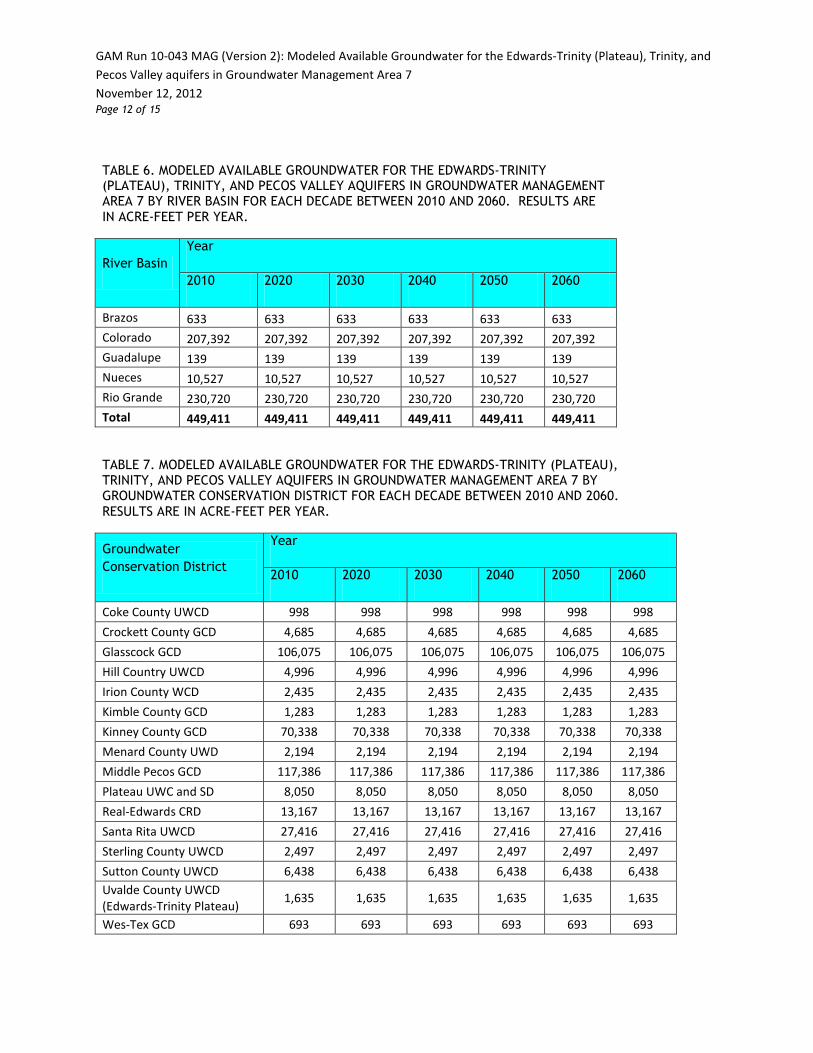
River Basin Year
2010 2020 2030 2040 2050 2060
Brazos 633 633 633 633 633 633 Colorado 207,392 207,392 207,392 207,392 207,392 207,392 Guadalupe 139 139 139 139 139 139 Nueces 10,527 10,527 10,527 10,527 10,527 10,527 Rio Grande 230,720 230,720 230,720 230,720 230,720 230,720 Total 449,411 449,411 449,411 449,411 449,411 449,411
TABLE 7. MODELED AVAILABLE GROUNDWATER FOR THE EDWARDS-TRINITY (PLATEAU), TRINITY, AND PECOS VALLEY AQUIFERS IN GROUNDWATER MANAGEMENT AREA 7 BY GROUNDWATER CONSERVATION DISTRICT FOR EACH DECADE BETWEEN 2010 AND 2060. RESULTS ARE IN ACRE-FEET PER YEAR.
Groundwater Conservation District
Year
2010 2020 2030 2040 2050 2060
Coke County UWCD 998 998 998 998 998 998 Crockett County GCD 4,685 4,685 4,685 4,685 4,685 4,685 Glasscock GCD 106,075 106,075 106,075 106,075 106,075 106,075 Hill Country UWCD 4,996 4,996 4,996 4,996 4,996 4,996 Irion County WCD 2,435 2,435 2,435 2,435 2,435 2,435 Kimble County GCD 1,283 1,283 1,283 1,283 1,283 1,283 Kinney County GCD 70,338 70,338 70,338 70,338 70,338 70,338 Menard County UWD 2,194 2,194 2,194 2,194 2,194 2,194 Middle Pecos GCD 117,386 117,386 117,386 117,386 117,386 117,386 Plateau UWC and SD 8,050 8,050 8,050 8,050 8,050 8,050 Real-Edwards CRD 13,167 13,167 13,167 13,167 13,167 13,167 Santa Rita UWCD 27,416 27,416 27,416 27,416 27,416 27,416 Sterling County UWCD 2,497 2,497 2,497 2,497 2,497 2,497 Sutton County UWCD 6,438 6,438 6,438 6,438 6,438 6,438 Uvalde County UWCD (Edwards-Trinity Plateau) 1,635 1,635 1,635 1,635 1,635 1,635
Wes-Tex GCD 693 693 693 693 693 693

GAM Run 10-043 MAG (Version 2): Modeled Available Groundwater for the Edwards-Trinity (Plateau), Trinity, and Pecos Valley aquifers in Groundwater Management Area 7 November 12, 2012 Page 13 of 15
TABLE 7. MODELED AVAILABLE GROUNDWATER FOR THE EDWARDS-TRINITY (PLATEAU), TRINITY, AND PECOS VALLEY AQUIFERS IN GROUNDWATER MANAGEMENT AREA 7 BY GROUNDWATER CONSERVATION DISTRICT FOR EACH DECADE BETWEEN 2010 AND 2060. RESULTS ARE IN ACRE-FEET PER YEAR.
Groundwater Conservation District
Year
2010 2020 2030 2040 2050 2060
Total (areas in districts relevant for joint planning) 370,286 370,286 370,286 370,286 370,286 370,286
No District 79,125 79,125 79,125 79,125 79,125 79,125 Total (all areas) 449,411 449,411 449,411 449,411 449,411 449,411

GAM Run 10-043 MAG (Version 2): Modeled Available Groundwater for the Edwards-Trinity (Plateau), Trinity, and Pecos Valley aquifers in Groundwater Management Area 7 November 12, 2012 Page 14 of 15
FIGURE 1. MAP SHOWING THE BOUNDARY OF THE EDWARDS-TRINITY (PLATEAU), PECOS VALLEY, AND TRINITY AQUIFERS ACCORDING TO THE 2007 STATE WATER PLAN (TWDB, 2007).

GAM Run 10-043 MAG (Version 2): Modeled Available Groundwater for the Edwards-Trinity (Plateau), Trinity, and Pecos Valley aquifers in Groundwater Management Area 7 November 12, 2012 Page 15 of 15
FIGURE 2. MAP SHOWING REGIONAL WATER PLANNING AREAS, GROUNDWATER CONSERVATION DISTRICTS, COUNTIES, AND RIVER BASINS IN AND NEIGHBORING GROUNDWATER MANAGEMENT AREA 7.


Appendix C
GAM Run 12-002 MAG: Modeled Available Groundwater for the Edwards (Balcones Fault Zone) Aquifer in Groundwater Management Area 10 for Kinney County


This page is intentionally blank.

GAM RUN 12-002 MAG: MODELED AVAILABLE GROUNDWATER FOR THE EDWARDS (BALCONES FAULT ZONE) AQUIFER IN
GROUNDWATER MANAGEMENT AREA 10 FOR KINNEY COUNTY
by Jerry Shi, Ph.D. Texas Water Development Board Groundwater Resources Division
Groundwater Availability Modeling Section (512) 463-5076
July 24, 2012
EXECUTIVE SUMMARY:
The modeled available groundwater for the Groundwater Management Area 10 portion of the Edwards (Balcones Fault Zone) Aquifer in Kinney County is listed by river basin and regional water planning area in Table 1, and groundwater conservation district in Table 2. This model run incorporates the desired future condition for the area adopted by the members of Groundwater Management Area 10 of maintaining a minimum water level of 1,184 feet above mean sea level in well number 70-38-902. The modeled available groundwater from the Edwards (Balcones Fault Zone) Aquifer in Groundwater Management Area 10 in Kinney County that results from the requested desired future condition is approximately 6,300 acre-feet per year from 2010 to 2060.
REQUESTOR:
Mr. Rick Illgner of Edwards Aquifer Authority on behalf of Groundwater Management Area 10.
DESCRIPTION OF REQUEST:
In a letter dated August 24, 2010, Mr. Illgner provided the Texas Water Development Board (TWDB) with the desired future condition of the Edwards (Balcones Fault Zone) Aquifer in Groundwater Management Area 10 in Kinney County. The desired future condition for the aquifer, as described in Resolution No. 2010-08 and adopted

GAM Run 12-002 MAG: Modeled Available Groundwater for the Edwards (Balcones Fault Zone) Aquifer in Groundwater Management Area 10 for Kinney County July 24, 2012 Page 4 of 9
August 4, 2010 by the groundwater conservation districts within Groundwater Management Area 10, are described below:
The district members of Groundwater Management Area 10 adopt the scenario for Kinney County that the DFC [Desired Future Condition] shall be that the water level in well number 70-38-902 shall not fall below 1184 feet MSL [Mean Sea Level]
METHODS, PARAMETERS AND ASSUMPTIONS:
The desired future condition for Kinney County was achieved in a new model run (Shi and others, 2012). The new model run is an update of Scenario 3 of Groundwater Availability Modeling (GAM) Task 10-027 (revised) (Hutchison, 2011). Both model runs were based on the MODFLOW-2000 model developed by the TWDB to assist with the joint planning process regarding the Kinney County Groundwater Conservation District (Hutchison and others, 2011). In both model runs, the total pumping in Kinney County was maintained at approximately 77,000 acre-feet per year to achieve the desired future condition. Details regarding this new model run are summarized in Shi and others (2012).
The location of the Edwards (Balcones Fault Zone) Aquifer is shown in Figure 1.
RESULTS:
The modeled available groundwater from the Groundwater Management Area 10 portion of the Edwards (Balcones Fault Zone) Aquifer in Kinney County that stems from the desired future condition is approximately 6,300 acre-feet per year (Tables 1 and 2). These tables contain the modeled available groundwater for the aquifer subdivided by regional water planning area, river basin, and groundwater conservation district for use in the regional water planning process. These areas are shown in Figure 2.
LIMITATIONS:
The groundwater model used in developing estimates of modeled available groundwater is the best available scientific tool that can be used to estimate the pumping that will achieve the desired future conditions. Although the groundwater model used in this analysis is the best available scientific tool for this purpose, it, like

GAM Run 12-002 MAG: Modeled Available Groundwater for the Edwards (Balcones Fault Zone) Aquifer in Groundwater Management Area 10 for Kinney County July 24, 2012 Page 5 of 9
all models, has limitations. In reviewing the use of models in environmental regulatory decision-making, the National Research Council (2007) noted:
“Models will always be constrained by computational limitations, assumptions, and knowledge gaps. They can best be viewed as tools to help inform decisions rather than as machines to generate truth or make decisions. Scientific advances will never make it possible to build a perfect model that accounts for every aspect of reality or to prove that a given model is correct in all respects for a particular regulatory application. These characteristics make evaluation of a regulatory model more complex than solely a comparison of measurement data with model results.”
A key aspect of using the groundwater model to develop estimates of modeled available groundwater is the need to make assumptions about the location in the aquifer where future pumping will occur. As actual pumping changes in the future, it will be necessary to evaluate the amount of that pumping as well as its location in the context of the assumptions associated with this analysis. Evaluating the amount and location of future pumping is as important as evaluating the changes in groundwater levels, spring flows, and other metrics that describe the condition of the groundwater resources in the area that relate to the adopted desired future condition.
Given these limitations, users of this information are cautioned that the modeled available groundwater numbers should not be considered a definitive, permanent description of the amount of groundwater that can be pumped to meet the adopted desired future condition. Because the application of the groundwater model was designed to address regional scale questions, the results are most effective on a regional scale. Texas Water Development Board Makes no warranties or representations relating to the actual conditions of any aquifer at a particular location or at a particular time.
It is important for groundwater conservation districts to monitor future groundwater pumping as well as whether or not they are achieving their desired future conditions. Because of the limitations of the groundwater model and the assumptions in this analysis, it is important that the groundwater conservation districts work with Texas Water Development Board to refine these modeled available groundwater numbers given the reality of how the aquifer responds to the actual amount and location of pumping now and in the future.
GAM Run 12-002 MAG: Modeled Available Groundwater for the Edwards (Balcones Fault Zone) Aquifer in Groundwater Management Area 10 for Kinney County July 24, 2012 Page 6 of 9
REFERENCES:
Hutchison, William R., 2011, GAM Task 10-027 (revised): Texas Water Development Board, GAM Task 10-027 Report, 8 p.
Hutchison, William R., Shi, Jerry, and Jigmond, Marius, 2011, Groundwater Flow Model of the Kinney County Area, Texas Water Development Board, 138 p.
National Research Council, 2007, Models in Environmental Regulatory Decision Making, Committee on Models in the Regulatory Decision Process, National Academies Press, Washington D.C., 287 p.
Shi, Jerry, Ridgeway, Cindy, and French, Larry, 2012, Draft GAM Task Report 12-002: Modeled Available Groundwater in Kinney County (April 11, 2012).
Texas Water Development Board, 2007, Water for Texas – 2007—Volumes I-III; Texas Water Development Board Document No. GP-8-1, 392 p.

GAM Run 12-002 MAG: Modeled Available Groundwater for the Edwards (Balcones Fault Zone) Aquifer in Groundwater Management Area 10 for Kinney County July 24, 2012 Page 7 of 9
TABLE 1. MODELED AVAILABLE GROUNDWATER FOR THE EDWARDS (BALCONES FAULT ZONE) AQUIFER IN GROUNDWATER MANAGEMENT AREA 10 IN KINNEY COUNTY. RESULTS ARE IN ACRE-FEET PER YEAR AND ARE DIVIDED BY COUNTY, REGIONAL WATER PLANNING AREA, AND RIVER BASIN.
County
Regional Water
Planning Area
River Basin
Year
2010 2020 2030 2040 2050 2060
Kinney J Nueces 6,319 6,319 6,319 6,319 6,319 6,319 Rio Grande
2 2 2 2 2 2
Total 6,321 6,321 6,321 6,321 6,321 6,321
TABLE 2. MODELED AVAILABLE GROUNDWATER FOR THE EDWARDS (BALCONES FAULT ZONE) AQUIFER IN GROUNDWATER MANAGEMENT AREA 10 BY GROUNDWATER CONSERVATION DISTRICT FOR EACH DECADE BETWEEN 2010 AND 2060. RESULTS ARE IN ACRE-FEET PER YEAR.
Groundwater Conservation District
Year
2010 2020 2030 2040 2050 2060
Kinney County GCD 6,321 6,321 6,321 6,321 6,321 6,321

GAM Run 12-002 MAG: Modeled Available Groundwater for the Edwards (Balcones Fault Zone) Aquifer in Groundwater Management Area 10 for Kinney County July 24, 2012 Page 8 of 9
FIGURE 1. MAP SHOWING THE BOUNDARY OF THE EDWARDS (BALCONES FAULT ZONE) AQUIFER ACCORDING TO THE 2007 STATE WATER PLAN (TWDB, 2007).

GAM Run 12-002 MAG: Modeled Available Groundwater for the Edwards (Balcones Fault Zone) Aquifer in Groundwater Management Area 10 for Kinney County July 24, 2012 Page 9 of 9
FIGURE 2. MAP SHOWING REGIONAL WATER PLANNING AREAS, GROUNDWATER CONSERVATION DISTRICTS, COUNTIES, AND RIVER BASINS IN AND NEIGHBORING GROUNDWATER MANAGEMENT AREA 10.
Appendix D
Estimated Historical Use and 2012 State Water Plan Datasets: Kinney County Groundwater Conservation District

Estimated Historical Water Use And 2012 State Water Plan Datasets:
Kinney County Groundwater Conservation District
by Stephen Allen Texas Water Development Board Groundwater Resources Division
Groundwater Technical Assistance Section [email protected]
(512) 463-7317 March 8, 2013
GROUNDWATER MANAGEMENT PLAN DATA: This package of water data reports (part 1 of a 2-part package of information) is being provided to groundwater conservation districts to help them meet the requirements for approval of their five- year groundwater management plan. Each report in the package addresses a specific numbered requirement in the Texas Water Development Board's groundwater management plan checklist. The checklist can be viewed and downloaded from this web address:
http://www.twdb.state.tx.us/groundwater/docs/GCD/GMPchecklist0113.pdf
The five reports included in part 1 are:
1. Estimated Historical Water Use (checklist Item 2)
from the TWDB Historical Water Use Survey (WUS)
2. Projected Surface Water Supplies (checklist Item 6)
3. Projected Water Demands (checklist Item 7)
4. Projected Water Supply Needs (checklist Item 8)
5. Projected Water Management Strategies (checklist Item 9)
reports 2-5 are from the 2012 State Water Plan (SWP) Part 2 of the 2-part package is the groundwater availability model (GAM) report. The District should have received, or will receive, this report from the Groundwater Availability Modeling Section. Questions about the GAM can be directed to Dr. Shirley Wade, [email protected], (512) 936-0883.

Estimated Historical Water Use and 2012 State Water Plan Dataset: Kinney County Groundwater Conservation District March 8, 2013 Page 2 of 8
DISCLAIMER: The data presented in this report represents the most updated Historical Water Use and 2012 State Water Planning data available as of 3/8/2013. Although it does not happen frequently, neither of these datasets are static and are subject to change pending the availability of more accurate data (Historical Water Use data) or an amendment to the 2012 State Water Plan (2012 State Water Planning data). District personnel must review these datasets and correct any discrepancies in order to ensure approval of their groundwater management plan.
The Historical Water Use dataset can be verified at this web address:
http://www.twdb.texas.gov/waterplanning/waterusesurvey/estimates/ The 2012 State Water Planning dataset can be verified by contacting Wendy Barron ([email protected] or 512-936-0886).
For additional questions regarding this data, please contact Stephen Allen ([email protected] or 512-463-7317) or Rima Petrossian ([email protected] or 512-936-2420).

Estimated Historical Water Use and 2012 State Water Plan Dataset: Kinney County Groundwater Conservation District March 8, 2013 Page 3 of 8
Estimated Historical Water Use
TWDB Historical Water Use Survey (WUS) Data
Groundwater and surface water historical use estimates are currently unavailable for calendar years 2005, 2011 and 2012. TWDB staff anticipates the calculation and posting of these estimates
at a later date.
KINNEY COUNTY All values are in acre-feet/year
Year Source Municipal Manufacturing Steam Electric Irrigation Mining Livestock Total
1974 GW 622 0 0 10,820 0 706 12,148
SW 0 0 0 3,497 0 74 3,571
1980 GW 1,031 0 0 9,308 0 495 10,834
SW 0 0 0 1,782 0 123 1,905
1984 GW 1,074 0 0 9,123 0 386 10,583
SW 0 0 0 1,515 0 96 1,611
1985 GW 1,057 0 0 4,634 0 375 6,066
SW 0 0 0 695 0 93 788
1986 GW 1,082 0 0 5,000 0 454 6,536
SW 0 0 0 0 0 113 113
1987 GW 1,058 0 0 2,083 0 506 3,647
SW 0 0 0 0 0 126 126
1988 GW 1,198 0 0 2,705 0 544 4,447
SW 0 0 0 477 0 136 613
1989 GW 1,379 30 0 10,498 0 496 12,403
SW 0 0 0 1,851 0 124 1,975
1990 GW 1,205 0 0 6,689 0 500 8,394
SW 0 0 0 1,180 0 124 1,304
1991 GW 1,036 0 0 6,689 0 519 8,244
SW 0 0 0 1,180 0 129 1,309
1992 GW 987 0 0 5,388 0 540 6,915
SW 0 0 0 1,347 0 135 1,482
1993 GW 1,126 0 0 9,025 0 473 10,624
SW 0 0 0 0 0 119 119
1994 GW 1,120 0 0 7,479 0 443 9,042
SW 0 0 0 0 0 110 110
1995 GW 1,114 0 0 5,859 0 429 7,402
SW 0 0 0 0 0 107 107
1996 GW 1,171 0 0 8,067 0 372 9,610
SW 0 0 0 0 0 93 93
1997 GW 1,174 0 0 6,987 0 313 8,474

Estimated Historical Water Use and 2012 State Water Plan Dataset: Kinney County Groundwater Conservation District March 8, 2013 Page 4 of 8
Estimated Historical Water Use
TWDB Historical Water Use Survey (WUS) Data
Groundwater and surface water historical use estimates are currently unavailable for calendar years 2005, 2011 and 2012. TWDB staff anticipates the calculation and posting of these estimates
at a later date.
Year Source Municipal Manufacturing Steam Electric Irrigation Mining Livestock Total
1997 SW 0 0 0 0 0 78 78
1998 GW 1,299 0 0 6,324 0 277 7,900
SW 0 0 0 0 0 69 69
1999 GW 1,220 0 0 4,359 0 323 5,902
SW 0 0 0 0 0 81 81
2000 GW 1,365 0 0 14,112 0 356 15,833
SW 0 0 0 0 0 89 89
2001 GW 838 0 0 5,965 0 172 6,975
SW 0 0 0 0 0 247 247
2002 GW 844 0 0 5,860 0 159 6,863
SW 0 0 0 0 0 228 228
2003 GW 1,162 0 0 9,868 0 117 11,147
SW 0 0 0 0 0 168 168
2004 GW 1,001 0 0 4,513 0 127 5,641
SW 0 0 0 0 0 182 182
2006 GW 1,126 0 0 4,776 0 238 6,140
SW 0 0 0 0 0 60 60
2007 GW 906 0 0 1,641 0 217 2,764
SW 0 0 0 0 0 55 55
2008 GW 1,101 0 0 2,043 0 294 3,438
SW 0 0 0 0 0 73 73
2009 GW 1,164 0 0 895 0 338 2,397
SW 0 0 0 0 0 84 84
2010 GW 1,026 0 0 1,258 0 184 2,468
SW 0 0 0 0 0 46 46

Estimated Historical Water Use and 2012 State Water Plan Dataset: Kinney County Groundwater Conservation District March 8, 2013 Page 5 of 8
Projected Surface Water Supplies
TWDB 2012 State Water Plan Data KINNEY COUNTY All values are in acre-feet/year
RWPG WUG WUG Basin Source Name 2010 2020 2030 2040 2050 2060
J BRACKETTVILLE RIO GRANDE LAS MORAS CREEK 2 2 2 2 2 2 COMBINED RUN-OF- RIVER J IRRIGATION NUECES WEST NUECES RIVER 0 0 0 0 0 0 COMBINED RUN-OF- RIVER J IRRIGATION RIO GRANDE ELM CREEK RUN-OF- 43 43 43 43 43 43 RIVER J IRRIGATION RIO GRANDE LAS MORAS CREEK 665 665 665 665 665 665 COMBINED RUN-OF- RIVER J IRRIGATION RIO GRANDE MUD CREEK 120 120 120 120 120 120 COMBINED RUN-OF- RIVER J IRRIGATION RIO GRANDE PINTO CREEK 95 95 95 95 95 95 COMBINED RUN-OF- RIVER J IRRIGATION RIO GRANDE RIO GRANDE 176 176 176 176 176 176 COMBINED RUN-OF- RIVER J LIVESTOCK NUECES OTHER LOCAL 45 45 45 45 45 45 SUPPLY J LIVESTOCK RIO GRANDE OTHER LOCAL 90 90 90 90 90 90 SUPPLY
Sum of Projected Surface Water Supplies (acre-feet/year) 1,236 1,236 1,236 1,236 1,236 1,236

Estimated Historical Water Use and 2012 State Water Plan Dataset: Kinney County Groundwater Conservation District March 8, 2013 Page 6 of 8
Projected Water Demands
TWDB 2012 State Water Plan Data
Please note that the demand numbers presented here include the plumbing code savings found in the Regional and State Water Plans.
KINNEY COUNTY All values are in acre-feet/year
RWPG WUG WUG Basin 2010 2020 2030 2040 2050 2060
J IRRIGATION NUECES 338 323 310 296 284 271
J LIVESTOCK NUECES 187 187 187 187 187 187
J COUNTY-OTHER NUECES 35 21 13 8 4 3
J BRACKETTVILLE RIO GRANDE 583 583 582 582 581 582
J COUNTY-OTHER RIO GRANDE 32 31 31 31 31 31
J IRRIGATION RIO GRANDE 13,169 12,605 12,063 11,547 11,053 10,582
J LIVESTOCK RIO GRANDE 258 258 258 258 258 258
J FORT CLARK SPRINGS MUD RIO GRANDE 626 653 678 704 723 727
Sum of Projected Water Demands (acre-feet/year) 15,228 14,661 14,122 13,613 13,121 12,641

Estimated Historical Water Use and 2012 State Water Plan Dataset: Kinney County Groundwater Conservation District March 8, 2013 Page 7 of 8
Projected Water Supply Needs
TWDB 2012 State Water Plan Data
Negative values (in red) reflect a projected water supply need, positive values a surplus. KINNEY COUNTY All values are in acre-feet/year
RWPG WUG WUG Basin 2010 2020 2030 2040 2050 2060
J BRACKETTVILLE RIO GRANDE 64 64 65 65 66 65
J COUNTY-OTHER NUECES 13 27 35 40 44 45
J COUNTY-OTHER RIO GRANDE 56 57 57 57 57 57
J FORT CLARK SPRINGS MUD RIO GRANDE 494 467 442 416 397 393
J IRRIGATION NUECES 4,044 4,059 4,072 4,086 4,098 4,111
J IRRIGATION RIO GRANDE 12,615 13,179 13,721 14,237 14,731 15,202
J LIVESTOCK NUECES 147 147 147 147 147 147
J LIVESTOCK RIO GRANDE 83 83 83 83 83 83
Sum of Projected Water Supply Needs (acre-feet/year) 0 0 0 0 0 0

Estimated Historical Water Use and 2012 State Water Plan Dataset: Kinney County Groundwater Conservation District March 8, 2013 Page 8 of 8
Projected Water Management Strategies
TWDB 2012 State Water Plan Data KINNEY COUNTY WUG, Basin (RWPG) All values are in acre-feet/year
Water Management Strategy Source Name [Origin] 2010 2020 2030 2040 2050 2060
BRACKETTVILLE, RIO GRANDE (J)
CONSERVATION: SYSTEM WATER AUDIT AND WATER LOSS AUDIT
CONSERVATION [KINNEY] 58 58 58 58 58 58
Sum of Projected Water Management Strategies (acre-feet/year) 58 58 58 58 58 58


Appendix E
GAM Run 12-014: Kinney County Groundwater Conservation District Management Plan


This page is intentionally blank

GAM RUN 12-014: KINNEY COUNTY
GROUNDWATER CONSERVATION DISTRICT
MANAGEMENT PLAN by Jerry Shi, Ph.D., P.G. and Shirley Wade, Ph.D., P.G.
Texas Water Development Board Groundwater Resources Division
Groundwater Availability Modeling Section Jerry Shi (512) 436-5076
Shirley Wade (512) 936-0883
February 11, 2013
EXECUTIVE SUMMARY:
Texas State Water Code, Section 36.1071, Subsection (h), states that, in developing
its groundwater management plan, groundwater conservation districts shall use
groundwater availability modeling information provided by the executive
administrator of the Texas Water Development Board in conjunction with any
available site-specific information provided by the district to the executive
administrator for review and comment. Information derived from groundwater
availability models that shall be used in the groundwater management plan includes:
the annual amount of recharge from precipitation to the groundwater
resources within the district, if any;
for each aquifer within the district, the annual volume of water that
discharges from the aquifer to springs and any surface water bodies,
including lakes, streams, and rivers; and
the annual volume of flow into and out of the district within each aquifer
and between aquifers in the district.
The purpose of this report is to provide Part 2 of a two-part package of information to
Kinney County Groundwater Conservation District for its groundwater management
plan. This groundwater management plan is due for approval by the executive
administrator of the Texas Water Development Board (TWDB) before June 19, 2013.
This report discusses the method, assumptions, and results from GAM run 12-014 using
the Kinney County Groundwater Conservation District model developed by Hutchison

GAM Run 12-014: Kinney County Conservation District Management Plan February 11, 2013
Page 4 of 11
and others (2011). The model has four layers representing the following hydrogeologic
units (from top to bottom): Carrizo-Wilcox Aquifer (layer 1), Upper Cretaceous Unit
(layer 2), Edwards (Balcones Fault Zone) Aquifer/Edwards portion of the Edwards-
Trinity (Plateau) Aquifer (layer 3), and Trinity portion of the Edwards-Trinity (Plateau)
Aquifer (layer 4). Tables 1 and 2 summarize the groundwater availability model data
for the official aquifers required by the statute. Figures 1 and 2 show the area of the
model from which the values in the tables were extracted using different combination
of model layers (as referenced below).
METHODS:
The Kinney County Groundwater Conservation District model (Hutchison and others,
2011) was used for this analysis. Water budgets for selected years—1980 through
2005—of the transient model period were extracted using ZONEBUDGET Version 3.01
(Harbaugh, 2009) and the average annual water budget values for recharge, surface
water outflow, lateral inflow to the district, lateral outflow from the district, and
flow between aquifers/geologic units located within the district are summarized in
this report. Please note that the Edwards (Balcones Fault Zone) Aquifer was simulated
in model layer 3, while the Edwards-Trinity (Plateau) Aquifer was simulated in model
layers 3 and 4.
PARAMETERS AND ASSUMPTIONS:
Edwards (Balcones Fault Zone) and Edwards-Trinity (Plateau) Aquifers
The Kinney County Groundwater Conservation District model developed by
Hutchison and others (2011) was used for this management plan data
analysis. The model was calibrated to water level and spring flux collected
from 1950 to 2005; however, data were extracted only for the period from
1980 to 2005 for the management plan. These dates were used to avoid
skewing the data as a result of the drought of the 1950s. The period from
1980 to 2005 includes both drought and wet climatic conditions.
The model has four layers representing the following hydrogeologic units
(from top to bottom): Carrizo-Wilcox Aquifer (layer 1), Upper Cretaceous
Unit (layer 2), Edwards (Balcones Fault Zone) Aquifer/Edwards portion of
the Edwards-Trinity (Plateau) Aquifer (layer 3), and Trinity portion of the
Edwards-Trinity (Plateau) Aquifer (layer 4). The model was run with
MODFLOW-2000 (Harbaugh and others, 2000).

GAM Run 12-014: Kinney County Conservation District Management Plan February 11, 2013
Page 5 of 11
RESULTS:
A groundwater budget summarizes the amount of water entering and leaving the
aquifer according to the groundwater availability model. Selected components were
extracted from the groundwater budget for the Edwards (Balcones Fault Zone) Aquifer
and the Edwards-Trinity (Plateau) Aquifer and averaged over the 1980 to 2005 portion
of the model runs in the district (Tables 1 and 2). These selected components are:
Precipitation recharge—The spatially-distributed recharge due to
precipitation within the district.
Surface water outflow—The total water discharging from the aquifers to
surface water features such as streams, reservoirs, and springs.
Flow into and out of district—The lateral flow within the aquifers between
the district and adjacent counties and other areas.
Flow between aquifers—The flow between aquifers or confining units. This
flow is controlled by the relative water levels in each aquifer or confining
unit and aquifer properties of each aquifer or confining unit that define the
amount of leakage that occurs.
The information needed for the District’s management plan is summarized in Tables 1
and 2. It is important to note that sub-regional water budgets are not exact. This is
due to the size of the model cells and the approach used to extract data from the
model. To avoid double accounting, a model cell that straddles a political boundary,
such as district or county boundaries, is assigned to one side of the boundary based on
the location of the centroid of the model cell. For example, if a cell contains two
counties, the cell is assigned to the county where the centroid of the cell is located
(Figures 1 and 2).
LIMITATIONS
The groundwater model used for this analysis is the best available scientific tool to
meet the stated objective. To the extent that this analysis will be used for planning
purposes and/or regulatory purposes related to pumping in the past and into the
future, it is important to recognize the assumptions and limitations associated with
the use of the results. In reviewing the use of models in environmental regulatory
decision making, the National Research Council (2007) noted:
“Models will always be constrained by computational limitations, assumptions, and knowledge gaps. They can best be viewed as tools to help inform decisions

GAM Run 12-014: Kinney County Conservation District Management Plan February 11, 2013
Page 6 of 11
rather than as machines to generate truth or make decisions. Scientific advances will never make it possible to build a perfect model that accounts for every aspect of reality or to prove that a given model is correct in all respects for a particular regulatory application. These characteristics make evaluation of a regulatory model more complex than solely a comparison of measurement data with model results.”
A key aspect of using the groundwater model to evaluate historic groundwater flow
conditions includes the assumptions about the location in the aquifer where historic
pumping was placed. Understanding the amount and location of historic pumping is as
important as evaluating the volume of groundwater flow into and out of the district,
between aquifers within the district (as applicable), interactions with surface water
(as applicable), recharge to the aquifer system (as applicable), and other metrics that
describe the impacts of that pumping. In addition, assumptions regarding
precipitation, recharge, and streamflow are specific to a particular historic time
period.
Because the application of the groundwater model was designed to address regional
scale questions, the results are most effective on a regional scale. The TWDB makes
no warranties or representations relating to the actual conditions of any aquifer at a
particular location or at a particular time.
It is important for groundwater conservation districts to monitor groundwater
pumping and overall conditions of the aquifer. Because of the limitations of the
groundwater model and the assumptions in this analysis, it is important that the
groundwater conservation districts work with the TWDB to refine this analysis in the
future given the reality of how the aquifer responds to the actual amount and
location of pumping now and in the future. Historic precipitation patterns also need
to be placed in context as future climatic conditions, such as dry and wet year
precipitation patterns, may differ and affect groundwater flow conditions.
REFERENCES:
Harbaugh, A. W., 2009, Zonebudget Version 3.01, A computer program for computing subregional water budgets for MODFLOW ground-water flow models, U.S. Geological Survey Groundwater Software.
Harbaugh, A.W., Banta, E.R., Hill, M.C., and McDonald, M.G., 2000, MODFLOW-2000, The U.S. Geological Survey modular ground-water model-user guide to modularization concepts and the ground-water flow process: U.S. Geological Survey Open-File Report 00-92, 121 p.

GAM Run 12-014: Kinney County Conservation District Management Plan February 11, 2013
Page 7 of 11
Hutchison, William R., Shi, Jerry, and Jigmond, Marius, 2011, Groundwater Flow Model of the Kinney County Area, Texas Water Development Board, 138 p.
National Research Council, 2007. Models in Environmental Regulatory Decision Making: Committee on Models in the Regulatory Decision Process, National Academies Press, Washington D.C., 287 p., http://www.nap.edu/catalog.php?record_id=11972.

GAM Run 12-014: Kinney County Conservation District Management Plan February 11, 2013
Page 8 of 11
TABLE 1: SUMMARIZED INFORMATION FOR THE EDWARDS (BALCONES FAULT ZONE) AQUIFER THAT IS NEEDED FOR KINNEY COUNTY GROUNDWATER CONSERVATION DISTRICT’S GROUNDWATER
MANAGEMENT PLAN. ALL VALUES ARE APPROXIMATE AND REPORTED IN ACRE-FEET PER YEAR.
Management Plan
requirement Aquifer and other units
TWDB Kinney GCD
Model (1980 – 2005)
Estimated annual amount of
recharge from precipitation to
the district
Edwards (Balcones Fault Zone)
Aquifer 17,674
Estimated annual volume of
water that discharges from the
aquifer to springs and any surface
water body including lakes,
streams, and rivers
Edwards (Balcones Fault Zone)
Aquifer 514
Estimated annual volume of flow
into the district within each
aquifer in the district
Edwards (Balcones Fault Zone)
Aquifer 268
Estimated annual volume of flow
out of the district within each
aquifer in the district
Edwards (Balcones Fault Zone)
Aquifer 12,346
Estimated net annual volume of
flow between each aquifer in the
district
From Upper Cretaceous Units to
Edwards (Balcones Fault Zone)
Aquifer
15,597
From Edwards-Trinity (Plateau)
Aquifer to Edwards (Balcones Fault
Zone) Aquifer
11,514
From Edwards (Balcones Fault
Zone) to Edwards-Trinity Units 33,598

GAM Run 12-014: Kinney County Conservation District Management Plan February 11, 2013
Page 9 of 11
TABLE 2: SUMMARIZED INFORMATION FOR THE EDWARDS-TRINITY (PLATEAU) AQUIFER THAT IS NEEDED FOR KINNEY COUNTY GROUNDWATER CONSERVATION DISTRICT’S GROUNDWATER
MANAGEMENT PLAN. ALL VALUES ARE APPROXIMATE AND REPORTED IN ACRE-FEET PER YEAR.
Management Plan
requirement Aquifer and other units
TWDB Kinney GCD
Model (1980 –
2005)
Estimated annual amount of
recharge from precipitation to
the district
Edwards-Trinity (Plateau) Aquifer 48,216
Estimated annual volume of
water that discharges from the
aquifer to springs and any surface
water body including lakes,
streams, and rivers
Edwards-Trinity (Plateau) Aquifer 33,439
Estimated annual volume of flow
into the district within each
aquifer in the district
Edwards-Trinity (Plateau) Aquifer 148,792
Estimated annual volume of flow
out of the district within each
aquifer in the district
Edwards-Trinity (Plateau) Aquifer 74,709
Estimated net annual volume of
flow between each aquifer in the
district
From Upper Cretaceous Units to
Edwards-Trinity (Plateau) Aquifer 40,848
From Edwards-Trinity (Plateau)
Aquifer to Edwards (Balcones Fault
Zone) Aquifer
11,514
From Edwards-Trinity (Plateau)
Aquifer to Edwards-Trinity Units 105,311

GAM Run 12-014: Kinney County Conservation District Management Plan February 11, 2013
Page 10 of 11
FIGURE 1: THE EDWARDS (BALCONES FAULT ZONE) AQUIFER AND EDWARDS PORTION OF THE EDWARDS-TRINITY (PLATEAU) AQUIFER IN MODEL LAYER 3 FROM WHICH THE INFORMATION IN TABLES 1 AND 2 WAS EXTRACTED FOR THE KINNEY COUNTY GROUNDWATER CONSERVATION DISTRICT.

GAM Run 12-014: Kinney County Conservation District Management Plan February 11, 2013
Page 11 of 11
FIGURE 2: THE TRINITY PORTION OF THE EDWARDS-TRINITY (PLATEAU) AQUIFER IN MODEL LAYER 4 FROM WHICH THE INFORMATION IN TABLES 1 AND 2 WAS EXTRACTED FOR THE KINNEY
COUNTY GROUNDWATER CONSERVATION DISTRICT.

Appendix F
Rules of the Kinney County Groundwater Conservation District


RULESOFTHE
KINNEYCOUNTYGROUNDWATER
CONSERVATIONDISTRICT
Adopted September 10, 2010
KinneyCountyGroundwaterConservationDistrictRulesAdoptedSeptember10,2010Page2of47
A. DISTRICT MISSION The mission of the Kinney County Groundwater Conservation District is to develop, promote, and implement water conservation and management strategies to conserve, preserve, and protect the groundwater supplies of the District, to protect and enhance recharge, prevent waste and pollution, and to promote efficient and beneficial use of groundwater within the District.
The District seeks to protect the rights of owners of water rights as defined in Texas Water Code, Chapter 36 (36.002) within the District from impairment of their groundwater quality and quantity from within the District and to guard against the same from outside the District by all means available, pursuant to the power and duties granted under Chapter 36, Subchapter D of the Texas Water Code.
The District desires to manage the production and quality of groundwater within the District on a sustainable basis that allows the capture of water flowing through the county without jeopardizing the viability of water in the county during extended periods of low rainfall or unduly increasing the frequency of the natural cycles for springs and intermittent streams going dry.

KinneyCountyGroundwaterConservationDistrictRulesAdoptedSeptember10,2010Page3of47
TABLE OF CONTENTS DISTRICT MISSION............................................................................................. 2 TABLE OF CONTENTS ....................................................................................... 3 SECTION 1 -- GENERAL PROVISIONS ........................................................... 6 RULE 1.01 PURPOSE OF RULES AND APPLICABILITY ............................ 6 RULE 1.02 DISTRICT ADDRESS ................................................................... 6 RULE 1.03 COMPUTING TIME ...................................................................... 6 RULE 1.04 METHODS OF SERVICE UNDER THE RULES ......................... 6 RULE 1.05 USE OF FORMS ............................................................................. 6 SECTION 2 -- REGISTRATION OF WELLS OR NEW WELLS ................... 7 RULE 2.01 REGISTRATION OF EXEMPT WELLS ....................................... 7 RULE 2.02 REGISTRATION OF NON-EXEMPT EXISTING WELLS ......... 7 RULE 2.03 PROCEDURE FOR DRILLING A WELL OR ............................... 7 REWORKING AN EXISTING WELL RULE 2.04 TERM OF DRILLING PERMIT .................................................... 8 RULE 2.05 SPACING ....................................................................................... 8 RULE 2.06 LOCATION OF WELLS AFTER EFFECTIVE DATE ................. 8 OF THESE RULES RULE 2.07 MINIMUM STANDARDS OF NEW WELL COMPLETION ...... 9 RULE 2.08 PERSONS AUTHORIZED TO CONSTRUCT ............................ 10 RULE 2.09 DRILLING LOGS ........................................................................ 10 SECTION 3 – PERMITS ..................................................................................... 11 RULE 3.01 TYPES OF PERMITS ................................................................... 11 RULE 3.02 EVALUATION OF PERMIT APPLICATION ............................ 11 RULE 3.03 REQUIREMENTS FOR A TESTING PERMIT .......................... 12 RULE 3.04 REQUIREMENTS FOR A REGULAR PERMIT ........................ 14 RULE 3.05 REQUIREMENTS FOR A TRANSPORT PERMIT .................... 15 RULE 3.06 PERMIT ACTIONS BY THE BOARD NOT ............................... 15 REQUIRING A HEARING RULE 3.07 PERMIT ACTIONS REQUIRING A CONTESTED ................... 16 CASE HEARING RULE 3.08 NEW REGULAR OR TRANSPORT PERMITS .......................... 19 ISSUED BY THE DISTRICT SECTION 4 -- PERMIT REQUIREMENTS..................................................... 20 RULE 4.01 PROHIBITION OF WASTE AND POLLUTION ........................ 20 RULE 4.02 REQUIRED EQUIPMENT ON WELLS ...................................... 20 RULE 4.03 LIMITATION ON PRODUCTION .............................................. 21 RULE 4.04 ANNUAL GROUNDWATER PUMPAGE REPORT ................. 21

KinneyCountyGroundwaterConservationDistrictRulesAdoptedSeptember10,2010Page4of47
RULE 4.05 REPLACEMENT WELLS ........................................................... 21 SECTION 5 -- PERMIT RENEWALS AND AMENDMENTS ...................... 22 RULE 5.01 PERMIT RENEWALS ................................................................. 22 RULE 5.02 PERMIT AMENDMENTS ........................................................... 22 SECTION 6 -- WATER TRANSPORT AND ENHANCEMENT OF ............ 23 GROUNDWATER FOR THE DISTRICT RULE 6.01 GENERAL PROVISIONS FOR TRANSPORT ........................... 23 RULE 6.02 APPLICATION FOR TRANSPORT PERMIT ............................ 25 RULE 6.03 HEARINGS FOR TRANSPORT PERMITS ................................ 26 RULE 6.04 PERMIT INFORMATION FOR TRANSPORT PERMITS ......... 27 RULE 6.05 EXEMPT WELLS REQUIRING PERMIT; FEES AND ............. 27 DISCHARGES UNDER STATE PERMITS RULE 6.06 REPORTING ................................................................................ 28 RULE 6.07 EXTENSION OF TRANSPORT PERMIT ................................... 28 RULE 6.08 REVOCATION OR MODIFICATION OF .................................. 28 TRANSPORT PERMIT SECTION 7 -- FEES AND DEPOSITS .............................................................. 28 RULE 7.01 WATER USE AND OTHER DISTRICT FEES ........................... 29 AND CHARGES RULE 7.02 APPLICATION FEES, REGISTRATION FEES, ........................ 30 AND OTHER FEES RULE 7.03 PAYMENT OF FEES ................................................................... 30 RULE 7.04 TRANSPORT PERMIT PROCESSING ...................................... 30 RULE 7.05 INSPECTION AND PLAN REVIEW FEES ................................ 30 RULE 7.06 EXCEPTIONS .............................................................................. 31 RULE 7.07 RECHARGE PROJECT ............................................................... 31 SECTION 8 -- MANAGEMENT ZONES .......................................................... 31 RULE 8.01 MANAGEMENT ZONES ............................................................ 31 RULE 8.02 ESTABLISHING AVAILABILITY OF ....................................... 31 GROUNDWATER IN MANAGEMENT ZONE RULE 8.03 PROPORTIONAL ADJUSTMENT ............................................. 32 SECTION 9 -- ENFORCEMENT AND VARIANCES .................................... 33 RULE 9.01 COMPLAINT AND INVESTIGATION ...................................... 33 RULE 9.02 ENFORCEMENT ......................................................................... 34 RULE 9.03 VARIANCES ................................................................................ 35 RULE 9.04 HEARINGS ON ENFORCEMENT ACTIONS ........................... 35 RULE 9.05 SEALING OF WELLS ................................................................. 36 RULE 9.06 CAPPING OF WELLS AND CREATION OF LIENS ................. 36 RULE 9.07 PLUGGING OF WELLS .............................................................. 37 RULE 9.08 ARTESIAN WELLS ..................................................................... 37

KinneyCountyGroundwaterConservationDistrictRulesAdoptedSeptember10,2010Page5of47
SECTION 10 -- REPEALED ............................................................................... 37 SECTION 11 -- REPEALED ............................................................................... 37 SECTION 12 -- RULES WITH PROCEDURES FOR RULEMAKING ....... 37 RULE 12.01 CONSTRUCTION ........................................................................ 37 RULE 12.02 USE AND EFFECT OF RULES ................................................... 37 RULE 12.03 HEADINGS AND CAPTIONS .................................................... 38 RULE 12.04 SEVERABILITY .......................................................................... 38 RULE 12.05 DEFINITION OF TERMS AND PHRASES ................................ 38 RULE 12.06 AMENDING OF RULES ............................................................. 38 RULE 12.07 RULEMAKING HEARING ......................................................... 38 RULE 12.08 EMERGENCY RULES ................................................................ 39 APPENDIX: GLOSSARY .................................................................................. 41
i. Types of Wells: .................................................................................. 46

KinneyCountyGroundwaterConservationDistrictRulesAdoptedSeptember10,2010Page6of47
SECTION 1 -- GENERAL PROVISIONS
RULE 1.01 PURPOSE OF RULES AND APPLICABILITY
These Rules are adopted to achieve the purposes of the District Act and accomplish its objectives and requirements as set out in the District’s Groundwater Management Plan.
With respect to any permit or permit application, these Rules govern the permitting process for any well that is not the subject of a pending permit application filed prior to the effective date of these Rules. Any permit application pending on the effective date of these Rules is governed by the Rules in effect at the time such application was filed with the District.
RULE 1.02 DISTRICT ADDRESS
The District’s mailing address is Post Office Box 369, Brackettville, Texas 78832. The office is located at 502 South Ellen Street, Brackettville, Texas.
RULE 1.03 COMPUTING TIME
In computing any period of time specified by these Rules, by a presiding officer, by board orders, or by law, the period shall begin on the day after the act, event, or default in question, and shall conclude on the last day of that designated period, unless the last day is a Saturday, Sunday, or legal holiday on which the District office is closed, in which case the period runs until the end of the next day which is neither a Saturday, Sunday, nor legal holiday on which the District office is closed.
RULE 1.04 METHODS OF SERVICE UNDER THE RULES
Except as otherwise provided for in these Rules, any notice or document required by these Rules to be served or delivered may be delivered to the recipient, or the recipient’s authorized representative, in person, by agent, by courier-receipted delivery, by certified or registered mail, return receipt requested, sent to recipient’s last known address, by e-mail to the recipient’s e-mail address on file with the District if written consent is granted by the recipient, or by facsimile document transfer to the recipient’s current facsimile number and shall be accomplished by 5:00 o’clock p.m. of the date on which it is due.
Service by mail is complete upon deposit in a post office or other official depository of the United States Postal Service. If service or delivery is by mail, and the recipient has the right to perform some act or is required to perform some act within a prescribed period of time after service, three days will be added to the prescribed period.
Service by telephonic document transfer is complete upon transfer, except that any transfer commencing after 5:00 o’clock p.m. shall be deemed complete the following business day.
Where service by other methods has proved unsuccessful, the service shall be complete upon publication of the notice in a newspaper of general circulation in the district.
RULE 1.05 USE OF FORMS
The District will furnish forms and instructions for the preparation of any application, declaration, registration or other document that is required to be filed with the District on

KinneyCountyGroundwaterConservationDistrictRulesAdoptedSeptember10,2010Page7of47
a form prepared by the District. The use of such forms is mandatory. Supplements may be attached if there is insufficient space on the form. Supplements must identify the sections of the form to which the information contained in the supplement pertains.
SECTION 2 -- REGISTRATION OF WELLS OR NEW WELLS
RULE 2.01 REGISTRATION OF EXEMPT WELLS
A) Exempt Wells. As used in these Rules, the phrase “exempt wells” means a well used solely for domestic use or for providing water for livestock, wildlife, or poultry equipped so that it is incapable of producing more than 25,000 gallons of groundwater a day or a monitoring well or any other well exempt from permitting under Chapter 36, Texas Water Code.
B) Registration. The District requires that all owners of exempt wells register the wells with the District on the approved District form for purpose of information gathering in the furtherance of groundwater management and groundwater planning. There is no fee for exempt well registration. No person owning or operating an exempt well may appear before the District in any permit hearing or other adjudication unless such well is first registered with the District. Exempt wells which have not been registered with the District cannot be included in any long-term water planning or aquifer management and this could result in negative water table conditions for such wells in the future.
C) Review by Office Staff. The Office Staff will review the completed form and determine if the well is exempt or non-exempt from the permit requirements of the District. If exempt, the Office Staff will issue a Registration Certificate with a well number.
D) Forfeiture of Exemption. A well exempt under this section will lose its exempt status if the well is subsequently used for a purpose or in a manner that is not exempt or illegal under these Rules or Chapter 36, Texas Water Code. Forfeiture of exempt status will occur upon notice to the well owner, following a hearing before the Board.
RULE 2.02 REGISTRATION OF NON-EXEMPT EXISTING WELLS
No person may operate a non-exempt, existing well without first obtaining a permit. The District does not require a permit or a permit application or a permit amendment for maintenance or repair of a well if the maintenance or repair does not increase the production capabilities of the well.
RULE 2.03 PROCEDURE FOR DRILLING A WELL OR REWORKING AN EXISTING WELL
A) Application. An application must be filed with the District to drill, equip, substantially alter or increase the output of an existing well by more than 5%. A violation of this Rule occurs on the first day of the drilling, equipping, completion, or alteration without the appropriate registration or permit. Fines may begin and continue each day thereafter until the appropriate registration or permit is issued.

KinneyCountyGroundwaterConservationDistrictRulesAdoptedSeptember10,2010Page8of47
B) Preparation of Application. An application for a well registration, permit, or permit amendment shall be made on forms provided by the District.
C) District Review. At the District President’s direction, either the Designated District Employee or President will review the application and make a preliminary determination of whether the well meets the exemption from permitting provided in these Rules and whether the well is in compliance with these Rules. The Applicant will be informed of the determination within five (5) business days from the date of receipt of the completed application.
1) Exempt Well. If the District President’s or Designated District Employee’s preliminary determination is that the well is exempt and in compliance with these Rules, and all applicable fees have been paid, the Applicant may begin construction or other activity immediately upon receiving the approved registration.
2) Non-Exempt Well. If the District President’s or Designated District Employee’s preliminary determination is that the well is not exempt, the Applicant must complete the process for a Test Permit under Rule 3.03.
RULE 2.04 TERM OF DRILLING PERMIT
A Permit issued in accordance with this rule will expire and be null and void with no further action of the Board if drilling of the well is not completed within 365 calendar days of the date the Permit is issued. Thereafter, the applicant must file a new Permit Application.
RULE 2.05 SPACING
A) An Exempt well must not be within fifty (50) feet of a neighboring property line. The President or the Designated District Employee may grant the Landowner a variance.
B) A Non-Exempt well must not be within 300 yards of a neighboring property line.
C) A written statement filed with the District from the neighbor stating that there is no objection to a well closer to the property line can override the yard spacing requirement in 2.05.B. This variance must be filed with the Kinney County Clerk and become a part of the County Record.
D) An Applicant may bring a request for an exception to subsection B) to the Board.
RULE 2.06 LOCATION OF WELLS AFTER EFFECTIVE DATE OF THESE RULES
A) Drilling Range. After an Application for a well permit has been granted, the well, if drilled must be drilled within thirty (30) feet of the location specified in the permit but not closer than fifty (50) feet from the property line if Exempt and 300 yards if Non-Exempt.
B) Location Restrictions. A well shall be located at a minimum distance of:
1) five hundred (500) feet from any sewage, wastewater, or other liquid-waste collection facility;

KinneyCountyGroundwaterConservationDistrictRulesAdoptedSeptember10,2010Page9of47
2) one hundred (100) feet from any concentrated source of contamination, including, but not limited to, a septic tank, septic drain field, or OSST spray field; and
3) five hundred (500) feet from a cemetery.
C) Flood Plains. If a new well shall not be located within a 100-year flood plain as defined by the Federal Emergency Management Agency, the well must comply with TWWDR 16 TAC §76 or its successor.
RULE 2.07 MINIMUM STANDARDS OF NEW WELL COMPLETION
A) Texas Well Drillers Rules. The minimum requirements for well drilling shall be the Texas Water Well Drillers Rules, 16 TAC § 76 or its successor. The District may, by Resolution, impose additional requirements for well drilling, as circumstances may require. To the extent that any Rule or Resolution adopted by the District is more restrictive than those imposed by the Texas Well Drillers Rules, the District’s Rule or Resolution shall be controlling.
B) Annular Space. The annular space between the borehole and the casing shall be filled from ground level to a minimum depth of twenty (20) feet with API Class A neat cement.
C) Sealing. A steel reinforced concrete slab or sealing block shall be placed above the cement around the casing at the ground surface.
1) Slab Block. The slab or block shall extend at least two (2) feet from the well in all directions, have a minimum thickness of four (4) inches to include 3/8th rebar at 12 inch o. c. or 6 x 6 x 10 mesh reinforcing wire.
2) Slab Surface Slope. The surface of the slab shall be sloped to drain away from the well.
D) Casing Top. The top of the casing shall extend a minimum of one (1) foot above the ground surface.
E) PVC Casing Instead of Concrete. If a well is to be completed with polyvinyl chloride (PVC) casing, in lieu of placing a concrete slab around the casing at the ground surface as provided for in section C) of this Rule, a steel sleeve may be used to protect the casing from breakage. The steel sleeve shall be a minimum of three-sixteenth (3/16) inches in thickness and eighteen (18) inches in length, shall extend six (6) inches in to neat cement, and shall be two (2) inches larger in diameter that the PVC casing being used.
F) Prohibition on Commingling of Aquifers. All wells that are to be completed in the artesian or confined portion of an aquifer shall be completed so that waters from other strata or zones are not allowed to commingle through the borehole-casing annulus. With respect to such wells, one of the following shall apply:
1) Steel Casing. If the well is to be completed with steel casing, the annular space between the borehole and the casing shall be filled with neat cement from the top of the water-bearing formation of production to the land surface.
2) PVC Casing. If the well is to be completed with PVC casing, the borehole-casing annulus shall be filled with cement, pelletized bentonite, grout, or other

KinneyCountyGroundwaterConservationDistrictRulesAdoptedSeptember10,2010Page10of47
suitable material if specifically approved by the Board, from the top of the water-bearing formation of production to the land surface provided that if cement is not used, a cement plug will be installed as required by the Texas Well Drillers Rules.
G) Gravel Packed Wells. If a well is to be gravel packed the full length of the casing, or string of casing must be set to the top of the desired aquifer formation and extend one foot above land surface. The second string of casing may then be set at the desired depth in the aquifer, and the annulus.
1) Gravel Packed Wells in Unconfined Portion of Aquifer. If a gravel packed well is to be drilled in the unconfined portion of an aquifer, it shall be completed with a double string of casing. The outside string of casing shall be set at a depth of twenty (20) feet below land surface, extend one foot above land surface, and shall be completed according to the Texas Well Drillers Rules. The second string of casing may then be set inside of the first string of casing at the desired depth in the aquifer, and the annulus between the two casings shall contain bentonite grout.
H) Undesirable Water. If a well penetrates any undesirable water in a zone or zones that contained water that differs in “chemical quality”, the undesirable water shall be sealed off and confined to its zone of origin. When undesirable water is encountered in a zone overlying fresh water, the well shall be cased from the top of the fresh water zone to the land surface and the annular space between the casing and the borehole shall be cemented to the land surface. When undesirable water is encountered in a zone underlying a fresh water zone, the portion of the well bore opposite the undesirable water zone shall be filled with cement to a height that will prevent the entrance of the undesirable water into the well.
I) Capping Well. The well casing shall be capped or completed in a manner that will prevent pollutants from entering the well.
RULE 2.08 PERSONS AUTHORIZED TO CONSTRUCT
Only licensed water well drillers in good standing with Texas Department of Licensing and Regulation (TDLR) and is not known to be in violation of any of the District’s Rules may construct water wells within the District.
RULE 2.09 DRILLING LOGS
A) Driller’s Logs Required. The driller of any water well within the District shall keep an accurate driller’s log for each well. The driller shall file a copy of each log and a report detailing the drilling, equipping, and completing of the well with the District within 60 days after the date the well is completed. The report shall include all information submitted by the driller to the TDLR. In the event that the driller’s log and report required under this section are not filed within 60 days after the date the well is completed, the driller shall be subject to enforcement by the District for violation of this Rule.
B) Uncompleted Wells. In the event the landowner prevents the driller from completing the well to state specifications, the driller shall report any uncompleted wells to the District. The landowner must cure the discrepancy within thirty (30) days or be subject to enforcement by the District for violation of these Rules.

KinneyCountyGroundwaterConservationDistrictRulesAdoptedSeptember10,2010Page11of47
C) Review of Drilling Logs. Within sixty (60) days of completion of the well, the Driller will submit completed well logs to the District. The Office Staff will review the logs and if satisfactory, issue a registration certificate with well number to the Applicant. Within thirty (30) calendar days following the next regular District Board meeting, the Office Staff shall return the $100 drilling deposit by District check.
SECTION 3 – PERMITS
RULE 3.01 TYPES OF PERMITS
A) Existing Use Permit. A permit on an existing, non-exempt well that was completed and operational on or before January 7, 2003, and that produced and used groundwater at any time during the Existing Use Period. The Existing Use Period is the period from January 1, 1992, through January 7, 2003.
B) Historic Use Permit. A permit on an existing, non-exempt well that was completed and operational on or before December 31, 1991, and that produced and used groundwater at any time during the Historic Use Period. The Historic Use Period is the period from January 1, 1960, through December 31, 1991.
C) Testing Permit. A permit for an existing or new well that has not had a hearing by the Board or has not been through a contested case hearing. All well production is on a temporary basis.
D) Regular Permit: A Permit issued after a hearing by the Board or a contested case hearing for a specified amount.
E) Transport Permit: Permit issued for water to be transported outside the District.
RULE 3.02 EVALUATION OF PERMIT APPLICATION
An application shall be limited to only one well. Applicant: For applications for a groundwater withdrawal permit, if the well or proposed well has one owner, that owner shall file the application. If there is more than one owner, a joint application shall be filed by those owners. In the case of more than one owner, the owners shall select one among them to act for and represent them before the District. Written documentation satisfactory to the District, must accompany the application. Unless the ownership of the well by the lessee, assignee, or easement holder isclearlyestablished in the documentation defining the relationship between parties, a lessee or designee of the surface estate or an easement holder, will not be considered the owner of the well. If the applicant is a lessee or owns groundwater rights severed from the surface estate, the applicant shall provide written notice of the application to each groundwater rights owner and surface estate owner by certified mail, return receipt requested. The application is not administratively complete until evidence of the notice provided, including the signed returned receipts or the refused or undelivered certified letters are provided to the District.

KinneyCountyGroundwaterConservationDistrictRulesAdoptedSeptember10,2010Page12of47
In deciding whether to issue a permit, and in setting the terms of the permit, the Board will consider the purpose of the District Act and all other relevant factors, including, but not limited to:
1) the application conforms to the requirements of Texas Water Code, Chapter 36 and is accompanied by the prescribed fees;
2) the proposed use of water unreasonably affects existing groundwater and surface water resources or existing permit holders;
3) the proposed use of water is dedicated to any beneficial use;
4) the proposed use of the water is consistent with the District’s certified water management plan;
5) the applicant has agreed to avoid waste and achieve water conservation; and
6) the applicant has agreed that reasonable diligence will be used to protect groundwater quality and that the applicant will follow well plugging guidelines at the time of well closure.
RULE 3.03 REQUIREMENTS FOR A TESTING PERMIT
Application. An Application must be filed with the District on a form provided by the district. A separate application is required for each well.
A) Minimum Requirements for Application. An application must contain the following information in sufficient detail to be considered administratively complete by the District:
1) Applicant’s Information. The application must contain the following information:
a) the name, mailing address, physical address, 911 emergency address and phone number of the applicant and the owner of the land on which the well is or will be located, supported by a run sheet from a title company duly licensed in the State of Texas;
b) shows or provides the documentation establishing the applicable authority to construct and operate a well for the proposed use, if the applicant is other than the owner of the property;
c) a statement of the nature and purpose of the proposed use and the approximate amount of water to be used for each purpose; and
d) a declaration that the applicant will comply with: i) the District’s Rules; ii) the District’s Groundwater Management Plan; iii) Texas Water Well Drillers Rules (16 TAC §76); iv) Texas Water Code; and v) the District’s drought contingency plan.
2) Technical Information. The application must be accompanied by a map that adequately details the proposed project, showing:
a) the project’s location on the map;
b) the project’s GPS location (Latitude and Longitude Coordinates);

KinneyCountyGroundwaterConservationDistrictRulesAdoptedSeptember10,2010Page13of47
c) the project’s surface elevation in feet above mean sea level (msl); and
d) all monitoring well locations.
3) Other Information. The application must also contain the following information:
a) the proposed pumping volume, in gallons per minute;
b) the pump horsepower;
c) the casing size in inches;
d) the depth of well (in feet) and producing formations;
e) a description of the use of the water to be pumped;
f) meter information from a District approved vender; and
g) mitigation plan – a water conservation plan or a declaration that the applicant will comply with the district’s management plan.
C) Completeness of Application. The Designated District Employee will review the application for completeness. An application shall be considered administratively complete if it (a) includes all information required, (b) is properly completed, signed, and notarized, (c) is accompanied by payment of all applicable fees; and (d) includes any maps, documents, or supplementary information requested by the Board or Staff. At the District’s President’s direction, either the Designated District Employee or President will make a determination of administrative completeness.
D) Action on Incompleteness. If the Designated District Employee or District President’s preliminary determination is that the well is exempt, but not in compliance with all District Rules, the Designated District Employee shall notify the applicant of the provisions that are not in compliance and the changes needed to bring the proposed well application into compliance. The applicant may resubmit the application to the District after correcting the appropriate provisions. The District will not take action on an application that is not administratively complete. An application may be rejected as not administratively complete if the District finds that substantive information required by the application or District staff is missing, false, or incorrect. The District will notify applicants submitting incomplete applications in writing. An Applicant shall have sixty (60) days from the date of the District’s notification to correct the application before the application expires.
E) Action on Administrative Completeness. If the Designated District Employee or District President determines that the application is administratively complete, the following shall occur:
1) The applicant will place notice of the proposed permit in a local newspaper published in Kinney County in a form approved by the District and proof of publication filed with the District.
2) Following publication in a local newspaper, the proposed Testing Permit will be placed on the next monthly meeting of the board.

KinneyCountyGroundwaterConservationDistrictRulesAdoptedSeptember10,2010Page14of47
3) If the Board approves the application, the Applicant will pump the well for a minimum of one (1) year or perform a pump test acceptable to the District. The Applicant must submit the actual amount pumped by providing monthly pumping reports. The District will reserve the right to observe, monitor, and inspect all phases of construction, and the pumping test. If the pumping rate causes detrimental impacts to the neighboring land owners wells, base spring flow or the aquifer the District shall have the authority to cause a decrease in pumping or stoppage of pumping until recharge has occurred. The pumping may be resumed at a reduced rate once conditions have normalized for the surrounding wells and springs. This process shall continue until a pumping rate is established which is not detrimental to any entity protected by the District’s Management Plan, and shall establish sustainable yield. The District must approve the meter and the meter installation. The Applicant will be responsible for notifying the District seven (7) days in advance for commencement of the above-named activities.
4) All monitoring wells must be registered with the District.
5) Within sixty (60) days from being noticed by the District, a person may request in writing to be an interested person with respect to the testing permit concerned. If the person seeking interested person status has one or more existing wells, that person must allow the District to monitor his or her well or wells during the one-year process to obtain interested person status. Such a request and offer to monitor is a prerequisite to becoming a protestant in any subsequent application for a non-temporary permit by the Applicant. The requirement to allow the District to monitor the person’s wells is to assess the impact that the Applicant’s future pumping may have on the person seeking interested person status. All permitted owners of surface water rights in the Groundwater Management Zone may request interested party status.
F) Compliance with Groundwater Management Plan. In issuing permits, the district shall manage total groundwater production on a long-term basis to achieve an applicable desired future condition and consider:
(1) the modeled available groundwater determined by the executive administrator;
(2) the executive administrator's estimate of the current and projected amount of groundwater produced under exemptions granted by district rules and Section 36.117;
(3) the amount of groundwater authorized under permits previously issued by the district;
(4) a reasonable estimate of the amount of groundwater that is actually produced under permits issued by the district; and
(5) yearly precipitation and production patterns.
RULE 3.04 REQUIREMENTS FOR A REGULAR PERMIT
Applicant must comply with Rule 3.02.
After granting a test permit by the District and the well has been pumped for a minimum

KinneyCountyGroundwaterConservationDistrictRulesAdoptedSeptember10,2010Page15of47
of one (1) year or an acceptable pumping test has been completed, the Applicant must submit an application for a Regular Permit to the District, on a form approved by the District, which must state the quantity pumped or requested to the District for review. The Applicant submission must contain a written request for a hearing on a form approved by the District.
RULE 3.05 REQUIREMENTS FOR A TRANSPORT PERMIT
Applicant wanting a Transport Permit must be a party to the water supply contract with the end user or be the end user.
The procedure for transport permit applications is described in more detail in Section 6.
RULE 3.06 PERMIT ACTIONS BY THE BOARD NOT REQUIRING A HEARING
A) Applications for Permits other than Test Permits. Within sixty (60) days from the date on which the District determination that an application is administratively complete, the application shall be set on the agenda for Board action at a Board meeting. Such setting shall be no later than the next available regularly scheduled Board meeting.
B) Open Meetings Notice. Notice required by the Open Meetings Act shall be provided for the meeting and shall include the name of the Applicant and the address or location of the well and other information deemed relevant by the District.
C) Notice to Applicant. Notice of the Board meeting at which the Application will be considered shall be mailed to the applicant at least seven (7) days prior to the scheduled meeting date. Such notice may be waived by the applicant.
D) Public Comment. Anyone interested in the Application may attend the meeting and make oral comments at the time designated for comments.
E) Oath Upon Comment. The Board shall administer the oath to the staff, the Applicant, and anyone who makes oral comments on the Application.
F) Board Action if No Request for Contested Case Hearing. If no request for a contested case hearing is made, the Board shall issue a written order or resolution reflecting its decision. If the Board approves the Application, the permit shall be an attachment to that written order or resolution. The Board’s decision shall be made within sixty (60) days after the Board meeting at which the Application was considered.
G) Effective Date if No Contested Case Hearing. The effective date of the written order shall be ten (10) days after the date on which the District President or the Presiding Officer, signs the order or resolution, if no request for a contested case hearing is received by the District. The order or resolution shall include a statement that the order or resolution and its attachment become effective and final within ten (10) days of that date. Any appeal authorized by Texas Water Code, Chapter 36, Subchapter H shall run from the effective date, because it is the date on which all administrative appeals to the District are final, unless there is a request for a contested case hearing.
H) Effective Date if Request for Contested Case Hearing Denied. If there is a timely

KinneyCountyGroundwaterConservationDistrictRulesAdoptedSeptember10,2010Page16of47
filed request for a contested case hearing and, the Board determines that there will be no contested case hearing, the effective date of the written order shall be the date on which the Board denies the contested case hearing.
RULE 3.07 PERMIT ACTIONS REQUIRING A CONTESTED CASE HEARING
A) Application. This Rule applies only to Applications for which the District has received a timely filed request for a contested case hearing.
B) Request for Contested Case Hearing and Party Status must be in writing. A person who is an owner of a permitted or registered well in the same management zone as the well application and who is willing to allow the District to monitor wells on his or her property may request Party Status in a contested case hearing. All requests for Party Status in a contested case hearing must be in writing and filed with the District. If a person allows the District to monitor his or her wells but the District does not monitor the well the person may provide well data from a credible source.
C) Pre-Hearing Conference. If the District receives a written request for a contested case hearing, the District shall schedule a pre-hearing conference at its next regularly scheduled Board meeting or at a Board meeting not less than thirty-five (35) days after the date of the request. The pre-hearing conference may be held to consider any matter which may expedite the hearing or otherwise facilitate the hearing process, including, but not limited to:
1) whether a valid contested case hearing request has been submitted and if so, the designation of parties;
2) the Contested Case Hearing Fee deposit amount required to be paid by each designated party;
3) formulation and simplification of issues; and
4) the hearing schedule, including any necessary discovery.
D) Open Meetings Notice. Notice required by the Open Meetings Act shall be provided for the hearing if conducted by a quorum of the Board.
E) Required Notices. In addition to the notice required by the Open Meeting Act, not later than the 10th day before the date of the hearing notice may be provided as follows:
1) post notice in a place readily accessible to the public at the District office;
2) provide notice to the County Clerk of Kinney County;
3) mail notice to the Applicant by regular mail;
4) mail notice to the individual requesting a contested case hearing by regular mail;
5) mail notice to the record owner, according to the Appraisal District Records of Kinney County, Texas, of all tracts of land overlying the groundwater rights if severed from the surface, all tracts of land adjoining the tract of land upon which the well is located or proposed to be located, and all Permitted owners of surface water rights within the Management Zone; and
Provide notice by mail, fax, or e-mail to any person who has requested notice under
KinneyCountyGroundwaterConservationDistrictRulesAdoptedSeptember10,2010Page17of47
Rule 3.07.G.
F) Requirements of Notice. Notice of the hearing on the Application shall include the following:
1) the name of the applicant;
2) the address or location of the well;
3) a brief explanation of the proposed permit or permit amendment, including the requested amount of groundwater, the purpose of the proposed use, and any change in use;
4) the time, date and location of the hearing; and
5) any other information the District considers relevant and appropriate.
G) Third Party Requests for Notice. Any person may submit to the District a written request for notice of a hearing on a permit or permit amendment. A request is effective for the remainder of the calendar year in which the request is received by the District. To receive notice of a hearing in a later year, a person must submit a new request. Failure to provide notice does not invalidate an action taken by the District at a contested case hearing.
H) Selection of Presiding Officer. The hearing may be conducted by a quorum of the
Board or the Board may appoint a Hearing Examiner to preside at and conduct the hearing on the Application. Conflict over Hearing Examiner will be settled by arbitration. The appointment of a Hearing Examiner shall be made in writing. If the hearing is conducted by a quorum of the Board, the President shall preside. If the President is not present, the Board shall select one of the Directors who is present to preside.
I) Duties of Presiding Officer. The presiding officer has the following authority and
obligations:
1) May convene the hearing at the time and place specified in the notice;
2) May set any necessary additional hearing dates;
3) May designate the parties regarding a contested application who qualify under Section 3.03 (E) (5);
4) May establish the order for presentation of evidence;
5) May administer oaths to all persons presenting testimony;
6) May examine persons presenting testimony;
7) May ensure that information and testimony are introduced as conveniently and expeditiously as possible without prejudicing the rights of any party;
8) Shall admit relevant evidence and may exclude evidence that is irrelevant, immaterial, or unduly repetitious;
9) May prescribe reasonable time limits for testimony and the presentation of evidence;
10) May allow testimony to be submitted in writing and sworn to. On the motion of a

KinneyCountyGroundwaterConservationDistrictRulesAdoptedSeptember10,2010Page18of47
party to the hearing, the presiding officer may exclude written testimony if the person who submits the testimony is not available for cross-examination by phone, a deposition before the hearing, or other reasonable means;
11) May continue a hearing from time to time and from place to place without providing notice under Rule 3.07.E. If the continuance is not announced on the record at the hearing, the presiding officer shall provide notice of the continued hearing by regular mail to the parities. In any event, if the hearing is being conducted by a quorum of the Board, Open Meetings notice under Rule 3.09.D shall be provided.
J) Recordings. Under Chapter 36.408, Texas Water Code, the presiding officer shall prepare and keep a record of each hearing in the form of an audio or video recording or a court reporter transcription. On the request of a party to a contested hearing, the presiding officer shall have the hearing transcribed by a court reporter. The presiding officer may assess any court reporter transcriptions cost against the party that requested the transcription or among the parties to the hearing. Except as provided by this subsection, the presiding office may exclude a party from further participation in a hearing for failure to pay in a timely manner costs assessed against that party under this subsection if the parties have agreed that the costs assessed against that party will be paid by another party. If a hearing is uncontested, the presiding officer may substitute minutes or the report required under Chapter 36.410.
K) Hearing Examiner’s Report. If a Hearing Examiner is to be the presiding officer at the hearing, the Hearing Examiner shall submit a report to the Board not later than thirty (30) days after the date the hearing is concluded. A copy shall be provided to the Applicant and each party to the hearing. The Applicant and other parities to the hearing may submit to the Board written exceptions to the report within ten (10) days of issuance of the report. The report shall include:
1) a summary of the subject matter of the hearing;
2) a summary of the evidence received; and
3) the Hearing Examiner’s recommendations for Board action on the subject matter of the hearing.
L) Board Action. Under Chapter 36.411 Texas Water Code, the board shall act on a permit or permit amendment application not later than the 60th day after the date the final hearing on the application is concluded.
M) Request for Rehearing or Findings and Conclusions. Requests for rehearing or for findings and conclusions shall be considered in the manner provided below.
1) Time for Filing. Not later than twenty (20) days after the date the Board issues its written order or resolution, an Applicant or a party to a contested case hearing may administratively appeal a decision of the Board on an Application by requesting written findings and conclusions of the Board.
2) Board Action. On receipt of a timely written request, the Board shall make written findings and conclusions regarding a decision of the Board on an Application. The Board shall provide certified copies of the findings and conclusions to the person who requested them, and to each designated party, not

KinneyCountyGroundwaterConservationDistrictRulesAdoptedSeptember10,2010Page19of47
later than thirty-five (35) days after the date the Board received the request. The Applicant or a party to the contested case hearing may request a rehearing before the Board not later than twenty (20) days after the date the Board issues the findings and conclusions.
3) Place of Filing; Required Information; Copies. A request for rehearing must be filed in the District office and must state the grounds for the request. The person requesting a rehearing must provide copies of the request to the parties.
4) If Rehearing Granted. If the Board grants a request for rehearing, the Board shall schedule the rehearing not later than forty-five (45) days after the date the request is granted. After the Board issues a written decision following the rehearing, no further requests for rehearing shall be considered. Any action by the Board on a request for rehearing shall be made at a Board meeting subject to the Open Meetings Act.
N) Final Decision. A decision by the Board on an Application is final if:
1) a request for rehearing is not filed on time, on the expiration of the period for filing a request for rehearing;
2) a request for rehearing is filed on time, on the date:
a) the Board denies the request for rehearing; or
b) the Board renders a written decision after granting the rehearing;
3) a request for rehearing is filed on time and the Board does not issue a written decision granting or denying the request for rehearing within 45 days from the date of the Board’s initial written order or resolution, on the 46th day after the Board issued its initial order or resolution; or
4) If the board grants a request for rehearing, the board shall schedule the rehearing not later than the 45th day after the date the request is granted. Chapter 36.412.d
5) The failure of the board to grant or deny a request for rehearing before the 91st day after the date the request is submitted is a denial of the request. Chapter 36.412.
O) Appeal to District Court. An Applicant or a party to a contested case hearing may appeal a District’s final decision under Texas Water Code, § 36.251 not later than the 60th day after the date on which the decision becomes final. A timely filed request for rehearing is a prerequisite to any such suit. No person may file a request for rehearing unless that person participated as an applicant, protestant, or other party in the hearing that resulted in the decision challenged.
RULE 3.08 NEW REGULAR OR TRANSPORT PERMITS ISSUED BY THE DISTRICT
A) Invoice for Fees. Upon the Board’s granting of a permit application, and prior to the issuance of the permit, the Designated District Employee shall promptly provide an invoice to the permit applicant for all water use fees and hearing fees due and owing to the District.
B) Payment of Fees Condition for Permit. The District will not issue a permit until all

KinneyCountyGroundwaterConservationDistrictRulesAdoptedSeptember10,2010Page20of47
applicable fees have been paid.
C) Change of Ownership. Within ninety (90) days after the date of a change in ownership of the right to produce water under a permit or registration, the existing permit or registration holder must notify the District. Notification must be in writing and provide legal proof of ownership in the form of a recorded deed or other instrument of title.
D) Standard Permit Provisions. All permits issued by the District shall state the following:
1) the name of the person to whom the permit is issued and the owner of the groundwater estate;
2) the date the permit is issued;
3) the date the permit expires;
4) the amount of water permitted;
5) the type of permit;
6) any conditions and restrictions placed on the rate and/or amount of groundwater withdrawal;
7) any other conditions or restrictions the District prescribes; and
8) any other information the District determines necessary.
SECTION 4 -- PERMIT REQUIREMENTS
RULE 4.01 PROHIBITION OF WASTE AND POLLUTION
A) Prohibition of Waste. No person shall intentionally or negligently commit waste. Groundwater produced from within the District shall not be used in such a manner or under such conditions as to constitute waste as defined in the Texas Water Code, Chapter 36.
B) Prohibition of Pollution. No person shall pollute or harmfully alter the character of the groundwater within the District by causing or allowing the introduction of pollutants or other deleterious matter from another stratum, from the surface, or from the operation of a well.
RULE 4.02 REQUIRED EQUIPMENT ON WELLS
A) Equipment Required for the Protection of Groundwater. Equipment must be installed on all wells having a chemical injection, chemigation or foreign substance unit in the water delivery system: an in-line, automatic quick-closing check valve capable of preventing pollution or harmful alteration of the groundwater. Such equipment must be installed on all new wells at the time of completion.
B) Equipment Required for Establishing Quantity of Groundwater Produced. All non-exempt wells must install meters and monitoring equipment approved by the District from a list of approved vendors. Monitoring equipment may include real-

KinneyCountyGroundwaterConservationDistrictRulesAdoptedSeptember10,2010Page21of47
time monitoring equipment installed at the District’s office at the well owner’s expense. The meter and monitoring equipment installation must be inspected by the District and schematic drawing of installation provided to the District. Metering Device failure must be reported to the District and the District must approve an appropriate measuring alternative. The purpose of the approved meter and monitoring equipment is to ensure that the District has the capability to promptly accurately measure the amount of groundwater being transported out of the District.
RULE 4.03 LIMITATION ON PRODUCTION
A) Limit Specified in Permit. The maximum annual quantity of groundwater that may be withdrawn under an Existing Use Permit, Historic Use Permit or Regular Permit issued by the District shall be no greater than the amount specified in the permit.
B) Aquifer-Based Production Limits. Using the best available hydrogeologic and geographic data, the District will continue to study and accumulate data on the various aquifers located within the boundaries of the District and their subdivisions, and may amend from time to time the limit on total annual production either throughout the District or for a particular aquifer or its subdivision, as set forth under these Rules.
RULE 4.04 ANNUAL GROUNDWATER PUMPAGE REPORT
Before January 15th of each year, each permit holder must submit to the District a report, on a form provided by the District, stating the following:
1) the name of the permit holder;
2) the well number(s);
3) the total amount of groundwater produced by the well or aggregate system during the immediately preceding calendar year (January through December);
4) the purpose for which the groundwater was used;
5) any other information requested by the District pursuant to the provisions of the District Act and Chapter 36, Texas Water Code.
The District requires an annual pumping report. However, the data provided by accurate monthly pumping reports is valuable to the District and the District requests all permit holders provide reports on a monthly basis.
RULE 4.05 REPLACEMENT WELLS
A) Application. A well owner may apply to re-equip, re-drill, or replace a currently permitted or registered well by filing an application to amend such permit or registration and providing such information as may be required by the District under the following conditions:
1) the replacement well must be drilled within fifty (50) feet of the location of the well being replaced, unless otherwise determined by the District;
2) the replacement well shall remain subject to the same permit provisions and requirements as the well being replaced, including the amount of maximum authorized withdrawal;

KinneyCountyGroundwaterConservationDistrictRulesAdoptedSeptember10,2010Page22of47
3) the replacement well or pump shall not be larger in size or capacity than the well being replaced so as to substantially alter the size or capacity of the well; and
4) if a replacement well is drilled, the well owner ceases production from the well being replaced and begins pursuit of compliance with the well closure requirements of the District for the well being replaced.
B) No-Hearing Required. Applications for replacement wells may be granted without notice or hearing.
SECTION 5 -- PERMIT RENEWALS AND AMENDMENTS
RULE 5.01 PERMIT RENEWALS
Any permit, except for transport permits, will renew March 1 of each year if all requirements of the Rules in effect at the time the permit was issued have been met and there are no outstanding fees owed.
RULE 5.02 PERMIT AMENDMENTS
A) Permit Amendment: A permit owner is required to obtain a permit amendment prior to (i) any change in the maximum amount of groundwater to be produced from a well, (ii) the location of a proposed well, (iii) the purpose of use of the groundwater allowed to be pumped under the permit, (iv) the location of use of the groundwater allowed to be pumped under the permit, or (v) the drilling and operation of additional wells even if aggregate withdrawals remain the same. The Board will consider applications for permit amendments in the manner prescribed for Test Well Permit applications. The fee to be assessed for any additional withdrawal granted shall be the fee rate in effect at the time of issuance of the amended permit multiplied by the additional withdrawal granted. Only a permit owner may seek a permit amendment.
B) Administrative Permit Amendment.
1) Transfer of Wells. Absent an express reservation of rights of the transferor, the transfer of ownership of the well(s) designated by a permit is presumed to transfer ownership of the permit. The ownership of a permit may be transferred separately from the ownership of a well or the land directly overlying the well, subject to these Rules and permit conditions.
2) Transfers of Permits. A permit holder may transfer the permit holder’s Existing Use Permit, Historic Use Permit, or Regular Permit only to another well within the same management zone, as provided under these Rules.
3) Administrative Permit Amendment. To bring about an Administrative Permit Amendment, the permit holder must file notice of the contemplated amendment with the District within ninety (90) days from the date of the change in ownership, along with any legal documents establishing the change in ownership. Upon receipt of the requisite notice, the District President or Office Staff, at the President’s direction, shall, upon determination that the proposed amendment is, in fact, a Ministerial Permit Amendment, grant the permit amendment and issue a revised permit. The District’s issuance of a permit amendment shall be made within thirty (30) calendar days after receipt of the requisite notice and the

KinneyCountyGroundwaterConservationDistrictRulesAdoptedSeptember10,2010Page23of47
documentation required.
C) Change in Purpose of Use or Place of Use. The scope of any review or hearing on an amendment to change the purpose of use or place of use authorized in the permit is limited to those elements that would have been different if the original permit application had included the provisions in the amendments related to the contemplated new purpose of use or place of use and may subject the permit holder to additional permitting hearings, including contested case hearings, as the Board may deem appropriate and as required by Chapter 36, Texas Water Code.
D) Application Fee and Other Fees. Each application for a permit amendment must be accompanied by the appropriate fees, as established by the Board.
SECTION 6 -- WATER TRANSPORT AND ENHANCEMENT OF GROUNDWATER FOR THE DISTRICT
RULE 6.01 GENERAL PROVISIONS FOR TRANSPORT
A) General Requirements for Transportation of Water. A person who produces or wishes to produce groundwater from a permitted well or aggregate wells located or to be located within the District and transport such groundwater for use outside of the District must first obtain a Regular Permit, or possess an Existing Use Permit, or Historic Use Permit. Any person or entity wishing to transport groundwater outside of the District boundaries must first file an application for and obtain a transport permit, pay all related fees, and cooperate with the District in establishing User/Purchaser fees and collection procedures to effect collection of the required charges imposed on water transported.
B) Exceptions to Transport Permit Requirement. A transport permit is not required for the transportation of groundwater outside of the District boundaries if (a) the groundwater is a part of a manufactured product or (b) used on property that (i) straddles the District boundary line and (ii) is owned by the owner or operator of the well(s) that produce the groundwater. A container used to transport water to a municipal water supplier is not a manufactured product.
C) Processing Fee. The District shall impose a fee for processing an application for a transport permit. The fee will be charged according to the current fee schedule as applicable to the required services and or professional and legal fees that may be required to process the application. An application filed under this Rule shall be considered and processed under the same or similar procedures as other applications for other permits as the circumstances of a particular application may require.
D) Use of Certain Revenues. The District is prohibited from using revenues obtained under subsection C) to prohibit the transport of groundwater outside of the District. The District is authorized to use revenues obtained under subsection C) to pay any expenses related to enforcement of the Rules or for any other authorized purpose of the District.
E) Conditions for Issuance of Transport Permit. The District shall not issue a transport permit unless the following conditions are satisfied.

KinneyCountyGroundwaterConservationDistrictRulesAdoptedSeptember10,2010Page24of47
1) The Applicant must be the end user or be a party to a contract with the end user. The applicant must have (a) secured via lease or purchase the right to a historic use permit, an existing use permit, and/or a regular operating permit that authorizes the Applicant to produce the groundwater that is desired to be transported, and (b) the Applicant must prove, in aggregate, the amount of water available for transport via the pump test as approved by the Board. All historic use or existing use permits attached to the Transport Permit will be suspended during the time the transport permit is in effect. A historic use or existing use permit tied to a transport permit shall forfeit all rights, privileges, and protection provided to those permits in the Management Plan, including the provisions of the Management Plan addressing drought contingencies during the time the water is being transported. When the Transport Permit is terminated, the underlying Historic, Existing and/or Regular Permits will be reinstated to the owner of said Permit.
2) The Applicant must submit a contract with the end user of the transported water for the District’s review and approval to ensure the contract contains all the provisions of the District’s Management Plan and Rules and shall contain a binding agreement on all parties to pay any and all taxes, fees, and assessments due and owing to the District.
3) The Applicant must submit a mitigation plan, previously approved by the District’s Board, and specific to the Management Zone or Zones from which groundwater will be withdrawn under the transport permit. A certified copy of the approved mitigation plan must be filed with the District before issuance of the transport permit.
F) Factors to be Considered. In reviewing an application for transport permit, the District shall consider:
1) the availability of water in the District and in the proposed receiving area during the period for which the water supply is requested, including any planned use;
2) the projected effect of the proposed transport on the aquifer conditions, depletion, and effects on existing permit holders or other groundwater users within the District;
3) the approved regional water plan and the District’s Groundwater Management Plan;
4) if the applicant has an underlying historic use or operating permit issued or being considered by the District, or a contract for the purchase of water from a person that has an operating permit.
G) Limitation of Volume of Groundwater Transported. The District may restrict a
transport permit by limiting the volume of groundwater for transport depending on the pump test prescribed in these Rules. Each transport permit shall specify the amount of water that may be transported and the period of time for which the water may be transported.
H) Term of Transport Permit. The term of duration of a transport permit shall be:
KinneyCountyGroundwaterConservationDistrictRulesAdoptedSeptember10,2010Page25of47
1) at least three years if construction of a conveyance system has not been initiated prior to the issuance of the transport permit; or
2) at least 30 years if construction of a conveyance system has been initiated prior to the issuance of the transport permit; and
3) notwithstanding the period specified in subsections 1) and 2) above, during which water may be transferred under a permit, the district shall continuously monitor the amount of water that may be transferred under the permit and may limit that amount if additional factors considered in Texas Water Code § 36.122(f) warrant the limitation, or if Production Limit Triggers established by the District’s Drought Contingency Plan have been reached. The amount of water that may be transferred under the permit shall be subject to continuous review and adjustment based on the Drought Contingency Plan, the Desired Future Conditions, and available groundwater factors.
I) REPEALED.
J) Limitations on District Discretion. The District may not impose more restrictive permit conditions on the owner of a transport permit than the District imposes on existing in-district users of water; provided, however, the District may establish provisions for direct payments of certain water user fees from destination users and remittance of those fees by destination users directly to the District. Subject to other applicable provisions of these Rules, the District shall not deny a permit under this Rule based on the fact that the Applicant seeks to transport groundwater out of the District.
K) Construction of Rule. In applying this Rule, the District must be fair, impartial, and non-discriminatory.
RULE 6.02 APPLICATION FOR TRANSPORT PERMIT
A) Use of District Form. A transport permit application must be filed with the District on a form prescribed by the District.
B) Requisites of Administratively Complete Application. An application for a transport permit must:
1) be in writing and sworn to before a person authorized to administer oaths in the State of Texas;
2) contain the name, mailing address, and place of residence or principal office of the Applicant, contain the name and mailing address of any lessee of the Applicant, and the name and mailing address of all landowners whose property interests in groundwater have been leased to the permittee;
3) contain the name and mailing address of the current fee simple owner or owners of the groundwater estate on the land on which the well or wells is to be located, supported by a run sheet from a title company duly licensed in the State of Texas;
4) identify the actual or anticipated location of the well from which the groundwater to be transported is produced or is proposed to be produced;
5) identify the pump size and production capacity of the well from which the

KinneyCountyGroundwaterConservationDistrictRulesAdoptedSeptember10,2010Page26of47
groundwater to be transported is produced or is proposed to be produced;
6) describe the proposed transport facilities;
7) state the nature and purposes of the proposed use and the anticipated amount of groundwater to be used for each purpose, including any proposed conjunctive use of surface and groundwater;
8) state the anticipated time within which any proposed construction or alteration of the transport facilities is to begin;
9) state the presently anticipated duration for the proposed transport of groundwater;
10) provide information showing what water conservation measures the Applicant has adopted, what water conservation goals the Applicant has established, and what measures and time frames are necessary to achieve the Applicant’s established water conservation goals;
11) if the water is to be resold to others, provide a description of the Applicant’s service area, metering, leak detection and repair program for its water storage, delivery and distribution system, drought or emergency water management plan, and information on each subsequent customer’s water demands, including population and customer data, water use data, water supply system data, alternative water supply, water conservation measures and goals, conjunctive use of surface and groundwater, and the means for implementation and enforcement of all applicable Rules, plans, and goals; and
12) contain an independent title opinion from an attorney duly licensed in the State of Texas that the proposed location of the wells and proposed use of the wells are not prohibited as a matter of restrictive covenants, easements, encumbrances, or other real covenants from withdrawing groundwater from the locations identified in the application.
C) Review for Administrative Completeness.
1) Review by District President or Office Staff. At the District President’s direction, the President or the Office Staff shall determine whether the application complies with the requirements of this Rule and may require amendment of the application to achieve necessary compliance.
2) Title Opinion from Independent Counsel. The provision of a satisfactory title opinion described in 6.02.B.12 is conclusive evidence in any contested case hearing that the Applicant is not prohibited as a matter of restrictive covenants, easements, encumbrances, or other real covenants from withdrawing groundwater from the locations identified in the application, subject to an order declaring otherwise from the Kinney County District Court.
D) Payment of Fees. An application must be accompanied by the required application fee established by the Board.
RULE 6.03 HEARINGS FOR TRANSPORT PERMITS
A) Declaration of Administratively Complete Application and Scheduling of Hearing. Within thirty (30) days after receiving and declaring an application administratively complete, the District will schedule a hearing on the application in

KinneyCountyGroundwaterConservationDistrictRulesAdoptedSeptember10,2010Page27of47
accordance with Rule 3.08.
B) Hearing on Application. Hearing on the application will be governed under Rule 3.05 or 3.06, as applicable.
C) Granting or Denying Permit. On approval of the Applicant’s transport permit application, the District shall issue a transport permit to the Applicant. The applicant’s right to transport groundwater shall be limited to the terms of the permit.
RULE 6.04 PERMIT INFORMATION FOR TRANSPORT PERMITS
Elements of Transport Permit. A transport permit issued by the District shall contain substantially the following information:
1) the name and mailing address of (a) the permittee, (b) any lessee of the permit, and (c) all landowners whose property interests in groundwater have been leased to the permittee;
2) the name and mailing address of the owner of the land from which the groundwater will be taken;
3) the date the permit is issued;
4) the period for which the groundwater may be transported;
5) the date the permit is to expire if no groundwater is transported;
6) the date the original application was filed;
7) a requirement that the groundwater withdrawn under the permit be put to beneficial use at all times;
8) the location of use of the transported groundwater;
9) the conditions and restrictions, if any, placed on the rate and amount of withdrawal;
10) the use or purpose for which the water is to be transported;
11) the maximum quantity of water to be transported annually;
12) any other information the District finds reasonably useful and beneficial;
13) standard terms and conditions for payment of the District’s transport fee and other fees authorized by the District;
14) terms of water use fees, collection, conditions, and fees to be paid if development or delay in actual use is sought and approved.
RULE 6.05 EXEMPT WELLS REQUIRING PERMIT; FEES AND DISCHARGES UNDER STATE PERMITS
A) Exempt Wells Not Excused from Requirement to Obtain Transport Permit. The owner of an exempt well is not excused from the requirements to obtain a transport permit and paying groundwater transport fees if the groundwater produced from the exempt well is transported outside of the District.
B) State Water Discharge. Groundwater that is discharged within the District pursuant to a permit issued by the Texas Railroad Commission or the Texas Commission on Environmental Quality is not considered to have been transported from the District

KinneyCountyGroundwaterConservationDistrictRulesAdoptedSeptember10,2010Page28of47
unless the discharge is part of an overall water transfer for use outside the District.
RULE 6.06 REPORTING
On or before February 15th of each year, the owner of a transport permit shall file an annual report with the District describing the amount of water transported under the permit. The report shall be filed on a form provided by the District and will include the following:
1) the name and mailing address of (a) the permittee, (b) any lessee of the permit, and (c) all landowners whose property interests in groundwater have been leased to the permittee;
2) the well numbers of each well for which the permittee holds a transport permit;
3) the total amount of groundwater transported from each well and total well system during the immediately preceding calendar year;
4) the total amount of groundwater transported from each well or well system during each month of the immediately preceding calendar year;
5) the purposes for which the water was transported;
6) fees paid through the report period; and
7) any other information requested by the District.
RULE 6.07 EXTENSION OF TRANSPORT PERMIT
A permittee may apply for an extension of the term of a transport permit granted under this Section. The District shall consider and grant or deny each application for extension of a transport permit in the same manner as is provided herein for the application for an initial permit.
RULE 6.08 REVOCATION OR MODIFICATION OF TRANSPORT PERMIT
A permit granted under this Section will be subject to review and modification as provided in these Rules. The permit shall also be subject to revocation for nonuse or waste by the permittee or for deviation from the purposes or other terms stated in the permit unless non-use has been specifically approved by the District and fees paid for such purpose. To revoke a permit for nonuse, the District must, at a public meeting, duly noticed under the Open Meetings Act and conducted not sooner than 10 days after the District has sent a copy of the Open Meetings Notice to the transport permit holder by certified mail, return receipt requested, determine that construction of a conveyance system has not been initiated within three years after issuance of the transport permit or that other conditions of the permit have not been met and form adequate grounds for revocation or non-renewal.
SECTION 7 -- FEES AND DEPOSITS

KinneyCountyGroundwaterConservationDistrictRulesAdoptedSeptember10,2010Page29of47
RULE 7.01 WATER USE AND OTHER DISTRICT FEES AND CHARGES
A) Water Use Fee Exemption. Except as otherwise provided in these Rules, exempt wells are exempt from payment of water use fees.
B) Schedule of Fees. The water use, permitted production, transport, permits, administrative functions including legal fees incurred by the district pertaining to an applicant’s permit, and other fees heretofore adopted by the Board are hereby ratified, confirmed and readopted by the Board and shall be enumerated. The Board shall, from time to time, adopt a schedule of fees for water use, non-use, production, transport, permits and administrative functions including professional fees to be paid by applicants, and any other lawful purpose or business of the District. The fees, rates and charges will be established in a schedule of fees and charges adopted by the Board, and each such schedule of fees and charges shall thereafter be and remain in effect until amended by the Board.
C) Authorized Production. The water use fee rate schedule established by the Board shall be applied to the total authorized annual production for each historic use, existing use, and regular permit. As used in this Section, when applied to the holder of a permit issued by the District, the term “water used” shall mean the total annual production authorized in the permit whether pumped or not pumped.
D) Water Use Fees. Water use fees shall be paid to the District for water that is authorized to be pumped from wells that are not exempted by these Rules or state laws from the payment of such fees. The water use fees and rates shall be established by the Board. Except as otherwise provided by these Rules or state law, the rate will be initially applied to total volume authorized to be pumped for a period designated by the Board. Following issuance of permits, the rate shall be applied to the total authorized annual production for each permit, including permits and amendments issued during the fiscal year the rate is in effect. Such annualized fees shall be pro-rated for the remainder of the calendar year in which the permit is issued, and one-twelfth of the annualized fee will be paid by the permittee at the end of each month remaining in that calendar year after the issuance of the permit.
E) Limit on Water Use Fees. Pursuant to the District Act, the water use fee may not exceed:
1) $1.00 per acre-foot for water used for irrigating agricultural crops; or
2) $10.00 per acre foot for water permitted for any other purpose.
F) Transport Fees. The District may establish a reasonable fee for the transport of groundwater, using one of the following methods:
1) a fee negotiated between the District and the transport permit holder; or
2) a fee rate not to exceed the equivalent of the district's tax rate per hundred dollars of valuation for each thousand gallons of water transferred out of the district, or $0.10 per thousand gallons of groundwater if the district assesses a tax rate of $0.10 per hundred dollars of valuation.
The District is prohibited from using revenues obtained from transport fees to prohibit

KinneyCountyGroundwaterConservationDistrictRulesAdoptedSeptember10,2010Page30of47
the transfer of groundwater outside the District, but may use transport fees for paying expenses related to any enforcement provisions of Chapter 36, Texas Water Code or the Rules, or for any other lawful purpose of the District.
All transport permits shall contain a condition that requires, as a condition to transporting water to a destination user, that the permit holder’s contract with a destination user require the destination user to assume responsibility for payment to the District of all due and owing resource impact fees in the event (a) the permit holder refuses to pay all due and owing water fees, (b) the permit holder is unable, for financial reasons, to pay all due and owing resource impact fees, or (c) the permit holder files for protection under any chapter of the United States Bankruptcy Code.
RULE 7.02 APPLICATION FEES, REGISTRATION FEES, AND OTHER FEES
All fees, rates and charges provided for in these Rules shall be charged and collected pursuant to a schedule of fees, rates and charges adopted by the Board.
The Board shall establish a schedule of fees, rates and charges for permit applications and administrative functions that generally relate to the costs incurred by the District in performing the administrative functions for which the fees are charged.
Payment of the water use fees allows the permit holder to use the water or reserve that amount of water in the aquifer.
The District’s monitor wells are exempt from all fees. At the District President’s direction, the President or Designated District Employee shall exempt monitoring wells from any other fees if the President or Designated District Employee determines that the assessment of the fee would result in the District charging itself a fee.
RULE 7.03 PAYMENT OF FEES
All permit fees are due at the time of application or registration or other time designated by the District. The annual water use and transport fee for each permit shall be paid as directed by the District from time-to-time and as determined necessary and suitable to assure proper accounting and un-interrupted receipt of such funds.
RULE 7.04 TRANSPORT PERMIT PROCESSING
The Board may adopt an application processing fee schedule for transport permits to cover all reasonable and necessary costs to the District of processing the application. The permit processing fee for an application to transport groundwater out of the District may not exceed the fees that the District imposes for processing applications for the use of groundwater within the District.
RULE 7.05 INSPECTION AND PLAN REVIEW FEES
The Board may establish fees for the inspection of wells, all measuring, water control, delivery and containment facilities, meters, or other inspection activities, plan reviews, special inspection services requested by other entities, or other similar services that require involvement of District personnel or its agents. Fees may be based on the amount of the District’s time and involvement, out-of-pocket costs, number of wells, well production, well bore, casing size, size of transporting facilities, or amounts of water transported.

KinneyCountyGroundwaterConservationDistrictRulesAdoptedSeptember10,2010Page31of47
RULE 7.06 EXCEPTIONS
If a regulated water utility or other entity is unable to pass through production fees due to delay in obtaining regulatory approval, or in other unusual instances of hardship, the Board may grant exceptions and establish a delay payment schedule. Such exceptions shall be applied consistently but shall consider the delay value of late receipt and the limited resource available to the District for use in accomplishing conservation and preservation activities of the District.
RULE 7.07 RECHARGE PROJECT
The District may undertake development of water resource conservation and recharge projects such as authorized by Public Law 83-566 for construction of recharge dams to impound less than 200 acre-feet of water or cause water to be channeled into sink holes or openings that will we replenish or confine water by storage for future use within the Aquifer. The Board, if such projects are undertaken, shall consider the costs and benefits and establish a project budget and directions and enter into necessary contracts for accomplishment of such public purposes. The Board shall solicit advice, and permits if needed from the Texas Water Development Board, Texas Commission on Environmental Quality, the Soil and Water Conservation District, and the United States Department of Agriculture concerning the effectiveness of such measures and develop a cost and project fee or assessment program for such improvements to compare to the resources available to the District.
SECTION 8 -- MANAGEMENT ZONES
RULE 8.01 MANAGEMENT ZONES
Using the best available scientific, hydrogeologic and geographic data, the Board shall divide the District into zones for the administration of groundwater management and regulation in the District. These management zones shall serve as areas for which the District shall determine separate and distinct water availability, which will be part of the aggregate water availability of the aquifer in which the management zone lies. In establishing a management zone, the District will, in each case, authorize total production, special drought management tools, and apportion available water among competing permit applicants, if applicable. The District shall attempt in defining management zones to utilize boundaries that, to the extent practicable, will promote fairness and efficiency by the District in its management of groundwater, but with emphasis given to scientific, hydrogeologic and geographic data.
RULE 8.02 ESTABLISHING AVAILABILITY OF GROUNDWATER IN MANAGEMENT ZONE.
A) Periodic Amendments. Every five years, or more frequently if the District is presented with significant new and credible information that justifies an earlier revision, the District shall use the best available scientific, hydrogeologic, and geographic information to determine or reevaluate the annual amount of groundwater available for withdrawal in each management zone, based upon the District

KinneyCountyGroundwaterConservationDistrictRulesAdoptedSeptember10,2010Page32of47
Management Plan and the information available to the District. To aid in this determination the District may conduct studies and tests, alone or jointly with other persons, or governmental entities; review and accept third party studies; and establish a series of index or monitoring wells.
B) Surplus of Managed Available Groundwater. As determined by the District, if the total amount of known production within a management zone (issued permits for withdrawal combined with District estimates of usage from exempt wells) is less than the amount of groundwater available for withdrawal within the management zone, as determined by the District under Subsection A), production amounts authorized under Existing Use Permits, Historic Use Permits and Regular Permits will remain the same and issued Regular permits may be increased or new Regular Permits issued, if applied for and as determined by the District in accordance with these Rules..
C) Shortage of Managed Available Groundwater. As determined by the District, if the total amount of known production within a management zone (issued permits for withdrawal combined with District estimates of usage from exempt wells) is greater than the amount of groundwater available for withdrawal within the management zone, as determined by the District under Subsection A), production amounts may be decreased proportionally among all permittees in the management zone, with any necessary reductions being applied first to Regular Permits, and subsequently, if production is still greater than availability, to Historic Use Permits, then, if production is still greater than availability, to Existing Use Permits, all in accordance with these Rules.
RULE 8.03 PROPORTIONAL ADJUSTMENT
The Board may establish proportional adjustment regulations to alter the amount of production allowed in a management zone, as set forth under these Rules, when available groundwater is less than known production. The Board must adhere to the following requirements when establishing proportional adjustment regulations:
1) The Board shall first set aside an amount of groundwater equal to an estimate of production from exempt wells located in the management zone. After setting aside the amount above, to the extent of remaining groundwater availability, the Board shall allocate groundwater to issued Existing Use Permits, Historic Use Permits, and Regular Permits in that order of priority.
2) If there is insufficient groundwater availability to satisfy any class of permits during such allocation, then the lower priority permits will be curtailed completely and within the higher priority class of permits the District will allocate the groundwater availability among the classes by reducing the amount authorized under each permit pro rata, based on the percentage each permit’s maximum permitted amount bears to the total permitted amount of all permits in that class. The priority of permits is established in the Groundwater Management Plan, Section 5.
3) If there is sufficient groundwater to satisfy all classes of permits in a management zone, the District will then allocate remaining groundwater availability to new or amended Regular Permits, if any, in accordance with these Rules.

KinneyCountyGroundwaterConservationDistrictRulesAdoptedSeptember10,2010Page33of47
4) If remaining available groundwater is less that the aggregate amounts of all new and amended Regular Permits in process at the District at the time of such determination, then the District will allocate such amount among the new and amended Regular Permits pro rata, based on the percentage each new or amended Regular Permit’s maximum permitted amount bears to the total permitted amount of all new and amended Regular Permits. With respect to new or amended Regular Permits involved in this allocation, to the extent the intended beneficial use is municipal or industrial and the amount of intended withdrawal is greater than 250 acre feet, the District will require documentary evidence from the end user of the ability and present intent to use the intended amount for the use stated and within the 5 year management zone adjustment cycle.
SECTION 9 -- ENFORCEMENT AND VARIANCES
RULE 9.01 COMPLAINT AND INVESTIGATION
A) Complaint Form. All complaints shall be reflected on a District complaint form. These forms are available at the District office. If a complaint is made verbally, by telephone, or in person, District personnel will ensure that the information is memorialized on a District compliant form, but no action will be taken until the complainant signs the District complaint form. The complainant must inform the District if the complainant wants to qualify as an aggrieved party under the citizen suit provision of Texas Water Code § 36.119.
B) Aggrieved Party. For purposes of this Rule and Texas Water Code § 36.119, an aggrieved party is a landowner or other person who has a right to produce groundwater from the land that is adjacent to the land on which the well subject to the complaint is located, or who owns or otherwise has a right to produce groundwater from land that lies within the same Groundwater Management Zone.
C) Investigation. One or more District representatives will investigate the complaint promptly and will memorialize his or her findings in a written investigation report.
D) Resolution of Complaint.
1) Informal Resolution. Upon filing of a complaint, the District President or Office Staff, at the President’s direction, shall contact the alleged violator and attempt to resolve the complaint informally.
2) Formal Investigation. If the complaint cannot be resolved informally, the District may enter onto any public or private property, pursuant to Texas Water Code § 36.123, and inspect and investigate the circumstances surrounding the complaint, as they relate to water quality, well conditions, and/or compliance with these Rules, permit conditions, or other orders issued by the District.
a) Minimal Intrusion. The District respects private property rights and shall endeavor to minimize any inconvenience to property owners while conducting District business. Whenever possible, the District shall notify, coordinate, and schedule well and property access in advance with the property owner, his

KinneyCountyGroundwaterConservationDistrictRulesAdoptedSeptember10,2010Page34of47
agent, tenant, or other local contact. Notice is not required if prior permission to enter land or access wells has been granted by the property owner, his agent, tenant, or other local contact.
b) Exhibit Credentials. District employees or agents accessing public or private wells or property shall exhibit proper credentials upon request.
c) Observe Rules and Regulations. District employees or agents acting under this authority shall observe all posted Rules and regulation concerning safety, internal security, and fire protection.
d) Immediate Inspections. If unexpected, emergency, or critical conditions require the District to access public or private wells or property without prior access arrangements, the District shall, at the first reasonable opportunity, contact the property owner, his agent, tenant, or other local contact. The District shall inform him that the District accessed the well or property, the reasons for the District’s access, and any pertinent information or action resulting from the District’s access.
3) Investigation Report. The District shall memorialize its investigation in an Investigation Report. A copy of the investigation report will be sent to the person about whom the complaint was made and to the complainant.
4) Board Consideration of Investigation Reports.
a) Time for Presenting Investigation Report. The investigation reports for all complaints must be presented to the Board for consideration not later than 90 days from the date of the receipt of the complaint.
b) Notice of Consideration of Investigation Report. Notice of the date, time and location of the Board meeting at which the investigation report will be considered and a copy of the investigation report shall be mailed to the person about whom the complaint was made and to the aggrieved party by certified mail, return receipt requested, at least ten days prior to the scheduled Board meeting.
c) Action on Investigation Report. At the Board meeting, the Board may decide that there was no violation and close the complainant file. If the Board decides that there has been a violation, it may direct the District staff to issue a Notice of Violation or initiate a civil enforcement under these Rules.
RULE 9.02 ENFORCEMENT
A) Administrative Enforcement. As authorized by Texas Water Code §36.102(b), the Board may adopt a schedule of penalties against any person for breach of any rule of the district not to exceed $10,000 per day per violation, and each day of a continuing violation constitutes a separate violation. Following notice and subject to the hearing provisions of Rule 9.04, the Board may suspend a permit until such time as all violations are cured and penalties paid.
B) Civil Enforcement. As authorized by Texas Water Code §36.102, the violation of any District Rule shall be subject to a civil penalty not to exceed $10,000 per day per violation, and each day of a continuing violation constitutes a separate violation. The

KinneyCountyGroundwaterConservationDistrictRulesAdoptedSeptember10,2010Page35of47
Board may seek enforcement of such civil penalties by injunction, mandatory injunction, or other appropriate remedy through a complaint filed in a court of competent jurisdiction. In addition the, District may seek and the court shall grant, recovery of attorney’s fees, costs for expert witnesses, and any other costs incurred by the District before the court.
C) Notice of Violation. The District shall send a notice of violation to a person who is believed to be in violation of the law, including violation of a District Rule, Order, or permit. The notice shall include a copy of the investigation report. The notice may require remedial action and may assess a penalty. The notice must advise the person who is believed to be in violation that he or she has an opportunity for public hearing.
D) Penalty Schedule. The District may assess penalties for noncompliance with District Rules including failure to comply with conditions of a permit issued by the District. Penalties will be assessed in accordance with the District’s Schedule of Fees and Fines. Penalties may be assessed per day per violation, with each day of a continuing violation constituting a separate violation.
E) Enforcement Costs. In addition to any penalty authorized by the District’s Schedule of Penalties, the District is entitled to recover expenses, including attorney's fees, costs for expert witnesses, court costs and other costs incurred by the District to enforce District Rules.
RULE 9.03 VARIANCES
Any exceptions or variance to the requirements imposed by the District Rules shall be considered on a case-by-case basis. A request for variance shall be submitted in writing and include the reasons for the request. All requests will be considered fairly and without prejudice.
RULE 9.04 HEARINGS ON ENFORCEMENT ACTIONS
A) Request for Hearing. If the District receives a filed written request for hearing from a Respondent who has received a notice of violation from the District within 30 days, the District shall decide at which Board meeting the enforcement action will be considered. The Board meeting which the enforcement action is considered under this Rule shall be considered the public hearing on the matter and fulfills the requirement, if any, for a public hearing.
B) Open Meetings Notice. Notice required by the Open Meetings Act shall be provided for the meeting.
C) Notice of Hearing. Notice of the hearing on the enforcement action shall be mailed to the Respondent by certified mail, return receipt requested, at least ten days prior to the scheduled hearing date.
D) Oath. The Board will administer the oath to the staff, the Respondent, the Aggrieved Party, and anyone who makes oral comment on behalf of any Aggrieved Party in the enforcement action.
E) Appointment of Hearings Officer or Committee. The Board, in its sole discretion, may appoint a Hearings Officer or committee of the Board to conduct the hearing on the enforcement action. In this Rule, either procedure is referred to as a Hearing

KinneyCountyGroundwaterConservationDistrictRulesAdoptedSeptember10,2010Page36of47
Body. Any hearing conducted by a Hearing Body shall be conducted in the same manner as provided under a Contested Case Hearing. At the close of the hearing, the Hearing Body, through the Hearings Officer or Presiding Officer, shall make a written recommendation to the Board. The recommendation shall become part of the record. The Board is not required to approve the recommendation of the Hearing Body.
F) Board Action. The Board shall issue a written order or resolution reflecting its decision.
G) Order or Resolution. The effective date of the written order shall be the date on which the President of the District signs the order or resolution. The order or resolution shall include a statement that the order or resolution becomes effective and final on that date. Any appeal authorized by Texas Water Code, Chapter 36, Subchapter H shall run from the effective date, because it is the date on which all administrative appeals to the district are final.
H) Costs of Hearing. If the Respondent is proven to not be in compliance with the Rules of the District under which his permit was issued, the District and the Respondent will bear the costs of the hearing. If the Respondent is not proven to be in violation of the Rules of the District under which the permit was issued, the District and the complainant will bear the costs of the hearing.
RULE 9.05 SEALING OF WELLS
Following public notice, the Board may order the sealing of a well that is in violation of District Rules or that has been prohibited from producing groundwater. The reasons for ordering the sealing of a well include, but are not limited to:
1) failure to apply for a test permit prior to drilling;
2) operating a well without the required permit; or
3) operating a well when the Board has denied, cancelled, or revoked a permit.
Once the Board has ordered a well sealed, the District, following the procedures in 9.01.D, shall seal the well by physical means, tag it to indicate that the well has been sealed by the District, or take any other appropriate action necessary to clearly indicate that the well has been sealed. The seal is intended to preclude operation of the well and/or identify unauthorized operation of the well.
Tampering with, altering, damaging, removing, or violating the seal of a sealed well in any way, or pumping groundwater from a well that has been sealed constitutes a violation of District Rules and subjects the person who performs that action, as well as the well owner, to enforcement and penalties pursuant to all applicable District Rules under which the permit was issued.
RULE 9.06 CAPPING OF WELLS AND CREATION OF LIENS
The District shall require an open uncovered well that is in a non-deteriorated condition to be capped to prevent waste, pollution, or prevent deterioration. The well shall remain capped until conditions that led to the capping are eliminated. The cap shall provide a sanitary seal to prevent the introduction of potential contaminants and shall be capable of sustaining a weight of at least four hundred (400) pounds. If the owner fails to close or

KinneyCountyGroundwaterConservationDistrictRulesAdoptedSeptember10,2010Page37of47
cap the well in compliance with the District Rules, the District, following the procedures 9.01.D, shall cap the well. Reasonable expenses incurred by the District in capping a well shall constitute a lien on the land on which the well is located pursuant to Texas Water Code § 36.118.
RULE 9.07 PLUGGING OF WELLS
The quality of our groundwater is important to the District. As such, it may be necessary to plug wells to protect the quality of our groundwater. If the condition of a well or the construction of a well causes contamination, the well shall be plugged or reconstructed to seal off the contaminating zone. All cost are the responsibility of the well owner.
The well owner may have up to 180 days to plug the well in accordance with Texas Department of Licensing and Regulation, 16 Texas Administrative Code, Chapter 76 Water Code and seal off the contaminating zone within the well.
However, if the level of contamination is such that it becomes perilous to human or animal consumption, immediate action will be taken to seal off the contamination and if necessary, plug the well. Any cost incurred by the District in taking immediate action, if the well owner fails to take such action, shall create a lien upon and be assessed against the owner’s land in accordance with Texas Water Code § 36.118.
RULE 9.08 ARTESIAN WELLS
Artesian wells which are free flowing at the well head will be maintained in as good a condition as is practicably possible to limit leakage.
SECTION 10 -- REPEALED
SECTION 11 -- REPEALED
SECTION 12 -- RULES WITH PROCEDURES FOR RULEMAKING
RULE 12.01 CONSTRUCTION
Unless otherwise expressly provided for in these Rules, the past, present and future tense shall each include the other; the masculine, feminine and neutral gender shall each include the other; and the singular and plural number shall include the other.
RULE 12.02 USE AND EFFECT OF RULES
These Rules are used by the District as legal requirements in the exercise of the powers conferred by law and in the accomplishment of the purposes of the District Act and Chapter 36 of the Texas Water Code. They shall not be construed as a limitation or restriction on the exercise of any discretion, where it exists, nor shall they be construed to deprive the District or Board of the exercise of any powers, duties or jurisdiction conferred by law; nor shall they be construed to limit or restrict the amount and character of data or information that may be required to be collected for the proper administration of the District Act or Chapter 36.

KinneyCountyGroundwaterConservationDistrictRulesAdoptedSeptember10,2010Page38of47
RULE 12.03 HEADINGS AND CAPTIONS
The section and other headings and captions contained in these Rules are for reference purposes only and do not affect in any way the meaning or interpretation of these Rules.
RULE 12.04 SEVERABILITY
In case any one or more of the provisions contained in these Rules shall for any reason be held to be invalid, illegal, or unenforceable in any respect, such invalidity, illegality, or unenforceability shall not affect any other Rules or provisions hereof, and these Rules shall be construed as if such invalid, illegal, or unenforceable Rule or provision had never been contained herein.
RULE 12.05 DEFINITION OF TERMS AND PHRASES
Unless expressly stated otherwise in any Rule, all terms and phrases shall be given the meaning assigned to them in the Glossary contained in the Appendix to these Rules, and if not defined therein, the meaning given to them by the Texas Water Code, and if not contained therein, according to their plain and ordinary meaning.
RULE 12.06 AMENDING OF RULES
The Board may, following notice and hearing, amend or repeal these Rules or adopt new Rules from time to time.
RULE 12.07 RULEMAKING HEARING
A) Rulemaking Hearing. Not later than the 20th day before the date of a rulemaking hearing, the Board shall:
1) post notice in a place readily accessible to the public at the District office;
2) provide notice to the county clerk of each County in the District;
3) publish notice in one or more newspapers of general circulation in the county or counties in which the District is located;
4) provide notice by mail, fax, or e-mail to any person who has requested notice under subsection E) below; and
5) make available a copy of all proposed Rules at a place accessible to the public during normal business hours.
B) Notice. The notice provided under subsection A) must include:
1) the time, date, and location of the rulemaking hearing;
2) a brief explanation of the subject of the rulemaking hearing: and
3) a location at which a copy of the proposed Rules may be reviewed or copied: and
4) a copy posted on the District’s Web Site.

KinneyCountyGroundwaterConservationDistrictRulesAdoptedSeptember10,2010Page39of47
C) Conduct of Rulemaking Hearing. The President of the Board or presiding officer shall conduct a rulemaking hearing in the manner the presiding officer determines to be most appropriate to obtain information and comments relating to the proposed rule as conveniently and expeditiously as possible. Comments may be submitted orally at the hearing or in writing. The presiding officer may hold the record open for a specified period after the conclusion of the hearing to receive additional written comments.
D) Hearing Registration Form. Each person who participates in a rulemaking hearing must submit a hearing registration form stating:
1) the person’s name;
2) the person’s address; and
3) whom the person represents, if the person is not at the hearing in the person’s individual capacity.
E) Record of Hearing. The President of the Board or presiding officer shall prepare and keep a record of each rulemaking hearing in the form of an audio or video recording or a court reporter transcription.
F) Request to Receive Notice. Any person may submit to the District a written request for notice of a rulemaking hearing. A request is effective for the remainder of the calendar year in which the request is received by the District. To receive notice of a rulemaking hearing in a later year, a person must submit a new request. An affidavit of an officer or employee of the District establishing attempted service by first class mail, facsimile, or e-mail to the person in accordance with the information provided by the person is proof that notice was provided by the District. Failure to provide notice under this subsection does not invalidate an action taken by the District at a rulemaking hearing.
G) Consideration of Proposed Rules. The District may use an informal conference or consultation to obtain the opinion and advice of interested persons about contemplated Rules and may appoint advisory committees of experts, interested person, or public representatives to advise the District about contemplated Rules.
RULE 12.08 EMERGENCY RULES
A) Conditions for Adoption of Emergency Rules. The Board may adopt an emergency Rule without prior notice or hearing, or with an abbreviated notice and hearing, if the Board:
1) finds a substantial likelihood of imminent peril to the public health, safety, or welfare, or a requirement of state or federal law, requires adoption of a Rule or less than 20 days’ notice; and
2) prepares a written statement of the reasons for its finding under subsection A)1), above.

KinneyCountyGroundwaterConservationDistrictRulesAdoptedSeptember10,2010Page40of47
B) Duration of Emergency Rules. Except as provided by subsection C), a Rule adopted under this section may not be effective for longer than 90 days, unless notice of a hearing on the final Rule is given not later than the 90th day after the date the emergency Rule is adopted, in which case the emergency Rule will be effective for an additional 90 days.
C) Open Meetings Act Compliance. A Rule adopted under this section must be adopted at an open and public meeting, held in accordance with Texas Government Code, Chapter 551.
END OF RULES

KinneyCountyGroundwaterConservationDistrictRulesAdoptedSeptember10,2010Page41of47
APPENDIX: GLOSSARY
DEFINITIONS OF TERMS
In the administration of its duties the District defines terms as set forth in Chapter 36 of the Texas Water Code unless otherwise modified or defined herein as necessary to apply to unique attributes of the District. The specific terms hereinafter defined shall have the following meaning in these Rules:
“Abandoned Well” shall mean a well that has not been used for six consecutive months. A well is considered to be “in use” if it is a non-deteriorated well (as per the requirements of 16 TAC 76, Texas Water Well Drillers Rules) in the following cases:
1) a well that contains the casing, pump, and pump column in good condition; or
2) a well that has been capped; or
3) an artesian flowing well with casing and a flow control device in good condition.
“Acre-foot” shall mean the amount of groundwater necessary to cover one acre of land to a depth of one foot (approximately 325,851 gallons).
“Agent” shall mean the person authorized to act on behalf of the landowner with respect to transactions involving the District or someone who acts on behalf of the District in the conduct of its business.
“Aggregate Wells” shall mean a well system comprised of two or more wells that are owned and operated by the same person or entity.
“Aggregate Withdrawal” shall mean the amount of groundwater withdrawn from two or more registered wells in a water system which is permitted under a single permit for a total pumpage volume of all wells in the aggregate.
“Aquifer” or “Groundwater Reservoir” shall mean a hydrogeologic unit or a group of saturated hydrogeologic units capable of storing and yielding groundwater in usable quantities or a geologic formation or a group of saturated geologic formations capable of storing and yielding groundwater in usable quantities.
“Annular Space” shall mean the space between two concentric cylindrical objects, one of which surrounds the other, such as the space between the walls of a drilled hole and the installed casing.
“Applicant for Regular Permit” – REPEALED.
“Applicant for a Transport Permit” – REPEALED.
“Artesian Well” shall mean a groundwater well completed in the confined portion of an aquifer such that, groundwater will rise in the well, by natural pressure, above an overlying impermeable stratum.
“Authorized Well Site” shall mean the location of a proposed well on a valid permit (an authorized well site is not a permit to drill).

KinneyCountyGroundwaterConservationDistrictRulesAdoptedSeptember10,2010Page42of47
“Bentonite” shall mean a sodium hydrous aluminum silicate clay mineral (montmorillonite) commercially available in powdered, granular, or pellet form which may be mixed with potable water and used to provide a seal in the annular space between the well casing and borehole wall or used in the plugging of wells.
“Board” shall mean the Board of Directors of the Kinney County Groundwater Conservation District.
“Capped Well” shall mean a well that is closed or capped with a covering capable of preventing surface pollutants from entering the well and sustaining a weight of at least 400 pounds and constructed in such a way that the covering cannot be easily removed by hand.
“Casing” shall mean a tubular watertight structure installed in the excavated or drilled hole, temporarily or permanently, to maintain the hole sidewalls against caving, and, along with cementing and/or bentonite grouting, to confine groundwater to its zone of origin and prevent surface contaminant infiltration. Casing diameter is the inside diameter of a well casing.
“Cement” shall mean a neat Portland construction cement mixture of not more than seven (7) gallons of water per 94-pound sack of dry cement, or a cement slurry which contains cement along with bentonite, gypsum, or other additives. All manufacturer’s recommendations regarding water content for the mix must be strictly adhered to.
“Chemigation” shall mean a process whereby pesticides, fertilizers or other chemicals, or effluent from animal or human wastes are added to irrigation water applied to land or crops, or both, through an irrigation system.
“Completion” shall mean sealing off the access of undesirable water to the well bore by proper casing and/or cementing procedures and adherence to State standards for completion.
“Discharge” shall mean the amount of water that leaves an aquifer by natural or artificial means.
“Director” shall mean an elected or appointed member of the Board of Directors of the District.
“District” shall mean the Kinney County Groundwater Conservation District, with its principal office in Brackettville, Texas. Where applications, reports, and other papers are required to be filed with or sent to “the District,” this shall mean the District’s Office, the mailing address of which is Post Office Box 369, Brackettville, Texas 78832. The District’s physical address will be established by the Board by Resolution.
“District Act” shall mean House Bill 3243 as enrolled by the 77th Texas Legislature, Regular Session, 2001, and the non-conflicting provisions of Chapter 36, Texas Water Code.
“Domestic Use” shall mean use of groundwater to supply the needs of a typical household, such as for drinking, washing, cooking, landscape watering, family gardening and watering of domestic animals, for which no monetary consideration is given or received. This includes the use of groundwater for home landscapes and home gardening on no more than two acres of land.
“Drought Contingency Plan” has the meaning set forth under 30 Texas Administrative Code, Section 288.1.
“Evidence of historic or existing use” shall mean evidence that is material and relevant to a determination of the amount of groundwater beneficially used without waste by a permit

KinneyCountyGroundwaterConservationDistrictRulesAdoptedSeptember10,2010Page43of47
applicant during the relevant time period set by district Rule that regulates groundwater based on historic use. Evidence in the form of oral or written testimony shall be subject to cross-examination. The Texas Rules of Evidence govern the admissibility and introduction of evidence of historic or existing use, except that evidence not admissible under the Texas Rule of Evidence may be admitted if is of the type commonly relied upon by reasonably prudent persons in the conduct of their affairs.
“Existing Use Period” shall mean the time period from January 1, 1992, through January 7, 2003.
“Existing and Historic Use Period” shall mean the time period that includes the Existing Use Period from January 1, 1992, through January 7, 2003, and the Historic Use Period from January 1, 1960, through December 31, 1991.
“Existing Use” shall mean production and beneficial, non-wasteful use of groundwater from an aquifer located within the District during the Existing Use Period.
“Federal Conservation Program” the Conservation Reserve Program of the United States Department of Agriculture”
“Fees” shall mean charges imposed by the District pursuant to District Rule, order, resolution, or the District Act.
“Fiscal Year” shall mean the business year of the District which shall be established by resolution of the Board.
“Groundwater or Underground Water” shall mean water percolating beneath the earth’s surface but does not include water produced with oil and gas production.
“Groundwater Right” shall mean a legally-definable right to produce groundwater from a certain tract of land evidenced by a written agreement or agreements with the landowner(s) such as a lease agreement, contract for sale, deed, or non-compete agreement. All such documents shall be filed of record in the Official Public Records of Kinney County, Texas.
“Historic Use” shall mean production and beneficial, non-wasteful use of groundwater from an aquifer located within the District during the Historic Use Period.
“Historic Use Period” shall mean the time period from January 1, 1960, through December 31, 1991.
“Industrial Use” shall mean the use of water in processes designed to convert materials of a lower order of value into forms having greater usability and commercial value, including commercial fish and shellfish production and the development of power by means other than hydroelectric, but does not include agricultural use.
“Irrigation” shall mean the application of water to plants or land in order to promote growth of plants, turf, or trees, excluding water used for domestic use.
“Irrigation Distribution System” shall mean a device or combination of devices having a hose, pipe or other conduit which connects directly to any groundwater well through which groundwater or a mixture of groundwater and chemicals which is drawn and applied to land. The term also includes a canal system. The term does not include any hand held hose sprayer or other similar device which is constructed so that an interruption in water flow automatically prevents any backflow to the water source.

KinneyCountyGroundwaterConservationDistrictRulesAdoptedSeptember10,2010Page44of47
“Managed Available Groundwater”(MAG) shall mean the amount of water that may be permitted by a district for beneficial use in accordance with the desired future condition of the aquifer as determined under section 36.108 of the Texas Water Code.
“Management Plan” shall mean a comprehensive groundwater conservation plan adopted by the District pursuant to Texas Water Code § 36.1071.
“Maximum Historic Use” shall mean the amount of groundwater that an permitee for an Existing Use Permit or a Historic Use Permit is authorized to withdraw from a well or aggregate wells located within the District, subject to the District’s Rules and conditions imposed upon the Permit issued by the District. A permittee’s Maximum Historic Use will be determined by the District upon demonstration of beneficial use during the Existing Use Period or Historic Use Period by the Applicant, and is equal to the following, unless proportionately adjusted:
1) for an applicant who demonstrates beneficial use during the Existing and Historic Use Period and does not qualify under Subsection (2) of this definition, the applicant’s actual maximum beneficial use of groundwater from an aquifer excluding waste during any one full calendar year of the Existing and Historic Use Period; or
2) for an applicant who demonstrates beneficial use during the Existing Use Period, but, due to the applicant’s groundwater production activities not having been commenced before January 7, 2002, and thus not in operation for the full 365 days of the final calendar year of the Existing Use Period, the applicant does not have beneficial use for a full calendar year, the applicant’s extrapolated maximum beneficial use calculated as follows: the amount of groundwater that would normally have been placed to the same beneficial use without waste by the applicant for the last full calendar year during the Existing Use Period for the applied for purpose had the applicant’s activities been commenced and in operation for the full final calendar year during the Existing Use Period.
“Meter” shall mean a water flow measurement device which meets American Water Works Association standards for the line size, pressures, and flows, and which is properly installed according to the manufacturer’s specifications, or other, alternative measuring method approved by the District capable of accurately measuring the actual volume of groundwater pumped and maintaining a cumulative record of measured flows. If the District approves an alternative measuring method, then the term “meter,” when used in these Rules, shall also apply to the alternative measuring method.
“Meter Reading” shall mean a written report of the readings taken from the meter installed on a permitted well, as required by the District.
“Ministerial Permit Amendment” shall mean solely an amendment to a permit to reflect a change in ownership of a well, permit, and/or land directly overlying a well.
“Open Meetings Act” shall mean Chapter 551, Texas Government Code.
“Operator” shall mean and includes any individual, firm, partnership, or corporation or other legal entity that has the right to produce groundwater from the land either by ownership, contract, lease, easement or any other estate in the land.

KinneyCountyGroundwaterConservationDistrictRulesAdoptedSeptember10,2010Page45of47
“Overpumpage” shall mean the withdrawal or aggregate withdrawal of groundwater from a well or aggregate wells in excess of the amount authorized to be withdrawn in accordance with these Rules or a permit issued by the District.
“Person” shall mean any individual, partnership, firm, state governmental agency, political subdivision, corporation or other legal entity.
“Permit” shall mean an authorization issued by the District allowing the drilling, equipping, completion, and/or alteration of a specific, designated non-exempt well or aggregate wells and withdrawal or aggregate withdrawal of a specific amount of groundwater from a non-exempt well or aggregate wells for a designated purpose and period of time, subject to District Rules and conditions that may be necessary to prevent waste and achieve water conservation, minimize as far as practicable the drawdown of the water table or the reduction of artesian pressure, lessen interference between wells, or control and prevent subsidence.
“Plugging” shall mean the permanent closure of a well in accordance with approved District standards.
“Plugging Authorization” shall mean an authorization issued by the District which defines the methods for the permanent closure of a well.
“Pollution” shall mean the alteration of the physical, thermal, chemical, or biological quality of, or the contamination of, any water in the District that renders the water harmful, detrimental, or injurious to humans, animal life, vegetation, or property or to public health, safety, or welfare, or impairs the usefulness or the public enjoyment of the water for any lawful or reasonable purpose.
“Presiding Officer” shall mean the President, Vice-President, Secretary, or other Board Member presiding at any hearing or other proceeding or a hearing examiner conducting any hearing or other proceeding.
“Public Information Act” shall mean Chapter 552, Texas Government Code.
“Pump, Pumpage, Produce, or Production” shall mean groundwater withdrawn, measured at the wellhead.
“Pump Installation” shall mean the procedures employed in the placement, and preparation for operation, of equipment and materials used to obtain groundwater from a well, including construction involved in establishing seals and safeguards as necessary to protect the groundwater from contamination. The term includes repairs to an existing pump.
“Recharge” shall mean the amount of water that infiltrates to the water table of the aquifer.”
“Recharge Zone” shall mean the area of an aquifer in which water infiltrates the surface and enters permeable rock layers.
“Re-equip” shall mean to replace any portion of the water producing equipment in a well.
“Registration” shall mean a certificate issued by the District for wells.
“Rework” shall mean to accomplish by any mechanical or chemical means the alteration of a well.
“Rules” shall mean the Rules of the District compiled herein, as may be repealed, and/or amended from time to time.
“Spring” shall mean a point of natural discharge from an aquifer.

KinneyCountyGroundwaterConservationDistrictRulesAdoptedSeptember10,2010Page46of47
“Substantially alter” with respect to the size or capacity of a well means to increase the inside diameter of the pump discharge column pipe size of the well in any way or to otherwise increase the capacity of the well to produce groundwater in an amount more than 5 percent greater than the well had the capacity to produce before the alterations.
“Sustainable Yield” the amount of water that can be produced from a well or well field production unit without jeopardizing the water supply to base spring flow, urban center wells, exempt wells, historic permit users or existing permit users. Reduced artesian well flow is not considered detrimental to aquifer.
“Transport of Groundwater” shall mean pumping, transferring, or moving groundwater out of the District, unless clearly indicated otherwise when read in context.
i. Types of Wells:
1) “Deteriorated Well” shall mean a well, the condition of which will cause, or is likely to cause, pollution of groundwater.
2) “Dewatering Well” shall mean a well used to remove groundwater from a construction site or excavation, or to relieve hydrostatic uplift on permanent structures.
3) “Exempt Well” shall mean a new or an existing well that is exempt from permitting under the laws of this State or these Rules and is not required to have a Regular, Existing Use, or Historic Use Permit to withdraw groundwater from an aquifer within the District.
4) “Existing Well” shall mean a well that was in existence or for which drilling commenced on or prior to January 7, 2003.
5) “Leachate Well” shall mean a well used to remove contamination from soil or groundwater.
6) “Monitoring Well” shall mean a well installed to measure some property of the groundwater or an aquifer that it penetrates, that does not produce more than 5,000 gallons per year.
7) “New Well” shall mean a proposed well or a well for which drilling has commenced on or after January 8, 2003.
8) “Non-exempt Well” shall mean any well that does not fall within the exclusions or exemptions set forth in these Rules.
9) “Public Water Supply Well” shall mean a well that produces the majority of its water for use by a public water system or a well that produces water primarily for residential use, but may have incidental commercial, industrial or other use, and from which the water is sold or distributed to the users by the well owner or operator (may include non-profit public corporations or municipalities).
“Undesirable Water” shall mean water that is injurious to human health, to vegetation, to land, or to fresh water, or water that can cause pollution.
“Waste” shall have the meaning assigned by Chapter 36, Texas Water Code, and in these Rules.

KinneyCountyGroundwaterConservationDistrictRulesAdoptedSeptember10,2010Page47of47
“Well” or “Water Well” shall mean and includes any artificial excavation constructed for the purpose of exploring for or producing or withdrawing groundwater, together with any device employed for such withdrawal.
“Well Operator” shall mean the person who operates a well or well system.
“Well Owner” shall mean the person who owns a possessory interest in: (1) the land upon which a well or well system is located; or (2) the well or well system.
“Well Log” or “Well Report” shall mean a record, made at the time of drilling, showing the depth, thickness, character of the different strata penetrated, location of any water-bearing strata, depth, size and character of casing installed, together with any other data or information required by the State or this Board and recorded on forms prescribed either by the State regulatory agency with jurisdiction thereof or by this Board.
“Well System” shall mean a group of wells connected or tied together by a pipeline and/or storage facilities.
“Withdraw” shall mean an act that results in taking groundwater from an aquifer by or through manmade facilities or conduits, including pumping or diverting groundwater from beneath the land surface by pumping or some other method or allowing groundwater to escape through a hole or other conduit that was created or altered by a person.


Appendix G
Evidence of Notice and Hearing:
Posted Agenda
Minutes of Meeting


Appendix H
Coordination with Surface Water Entities:
Email to Nueces River Authority
Email to International Boundary and Water Commisstion

1
Bill Hutchison
From: Peggy Sue Postell <[email protected]>Sent: Monday, June 17, 2013 1:05 PMTo: [email protected]; [email protected]: Bill Hutchison; Greg EllisSubject: KCGCD management planAttachments: 2013 final draft KCGCDplan.pdf
Dear Sirs, By way of this email and the attached copy of the Kinney County Groundwater Conservation District Management Plan, we are advising you of our updated plan approved on May 29, 2013. Please note that the primary update to the plan from the 2010 Revised Plan is the addition of Goals and Objectives related to desired future conditions and managed available groundwater. The majority of the plan remains unchanged.
Sincerely, Rene A. Villarreal, Administrative Assistant Kinney County Groundwater Conservation District Ph. (830)563-9699 Fax (830)563-9606
E-mail: [email protected]
The attached document contains information from the KCGCD office that is confidential and privileged, or may contain attorney work product. This information is intended only for the use of the addressee named above. If you are not the intended recipient, you are hereby notified that any disclosure, copying, or distribution of the email or attached documenhts, or taking any action in reliance on the contents of this message or its attachments is strictly prohibited, and may be unlawful. If you have received this message in error, please (1) immediately notify me by reply email, (2) do not review, copy, save, forward,or print this email or any of its attachments, and (3) immediately delete and destroy this email, its attachments and all copies thereof. Unintended trasnmission does not constitute waiver of the attorney-client privilege or any other privilege.