kings county planning commission
TRANSCRIPT

KINGS COUNTY PLANNING COMMISSION Regular Meeting Government Center 7:00 P.M. Hanford, California
AGENDA June 2, 2014
This meeting will be held in the Board of Supervisors Chambers, Administration Building No. 1, Kings County Government Center, 1400 W. Lacey Boulevard, Hanford, California. Pursuant to California Government Code Section 65009, subdivision (b), if you challenge the (nature of the proposed action) in court, you may be limited to raising only those issues you or someone else raised at the public hearing, or in written correspondence delivered to the Planning Commission at, or prior to, the public hearing. I. CALL TO ORDER - Kings County Planning Commission Meeting
1. REQUEST THAT CELL PHONES BE TURNED OFF 2. PLEDGE OF ALLEGIANCE 2. SUMMARY OF THE AGENDA - Staff 3. UNSCHEDULED APPEARANCES
Any person may address the Commission on any subject matter within the jurisdiction or responsibility of the Commission at the beginning of the meeting; or may elect to address the Commission on any agenda item at the time the item is called by the Chair, but before the matter is acted upon by the Commission. Unscheduled comments will be limited to five minutes.
4. APPROVAL OF MINUTES - Meeting of March 3, 2014. II. OLD BUSINESS None
III. NEW BUSINESS
1. CONDITIONAL USE PERMIT NO. 13-02 (GALES 3 MW SOLAR PROJECT) – A
proposal to establish a 3 Megawatt (MW) commercial photovoltaic solar energy generating facility located at 7749 7th Avenue, Hanford, Assessor’s Parcel Number 014-090-033. A. Staff Report B. Public Hearing C. Decision: Roll Call Vote
In compliance with the Americans with Disabilities Act, if you need special assistance to participate in this meeting, please contact the Community Development Agency at (559) 852-2680 by 4:00 p.m. on the Thursday prior to this meeting. Agenda backup information and any public records provided to the Commission after the posting of the agenda for this meeting will be available for public review at the Kings County Community Development Agency, Building No. 6, Kings County Government Center, 1400 W. Lacey Blvd., Hanford, California.

NOTICE OF RIGHT TO APPEAL: For projects where the Planning Commission's action is final, actions are subject to appeal by the applicant or any other directly affected person or party and no development proposed by the application may be authorized until the final date of the appeal period. An appeal may be filed with the Community Development Agency at 1400 W. Lacey Blvd., Building #6, Hanford, CA, on forms available at the Community Development Agency. A filing fee of $320.00 must accompany the appeal form. The appeal must be filed within 8 days of the Planning Commission's decision date, not including the date of the decision. If no appeal is received, the Planning Commission's action is final. There is no right of appeal for projects for which the Planning Commission's action is advisory to the Board of Supervisors.
2. ELECTION OF OFFICERS (for term of 7/1/14 to 6/30/15) A. Nominations for Chairman B. Decision C. Nominations for Vice-Chairman D. Decision
IV. MISCELLANEOUS
1. FUTURE MEETINGS - The next regular meeting of the Planning Commission is scheduled for Monday, July 7, 2014.
2. CORRESPONDENCE 3. STAFF COMMENTS 4. COMMISSION COMMENTS
V. ADJOURNMENT H:\PLANNING\LAND DEVELOPMENT SECTION\PLANNING COMMISSION\PC-AGENDA\2010 TO 2019\2014\6-2-14 PC AGENDA.DOC


Staff Report
C.U.P. No. 13-02 Page 1
KINGS COUNTY PLANNING COMMISSION STAFF REPORT
Conditional Use Permit No. 13-02
Zoning Ordinance No. 269.69 June 2, 2014
APPLICANT: Belectric, Inc. (Beth Hoffman – Project Developer), 8076 Central
Avenue, Newark, CA 94560 PROPERTY OWNERS: Helen Gales, 12509 Richmond Run Drive, Raleigh, NC 27614 LOCATION: The Project site is located at 7749 7th Avenue, Hanford City, CA.
The Project site consists of a 22 acre portion of a 28 acre parcel located within Assessor’s Parcel Number (APN) 014-090-033. The project facilities would be located 2.11 miles northeast of the City of Hanford, California.
GENERAL PLAN DESIGNATION: General Agriculture (AG-20) ZONE DISTRICT CLASSIFICATION: General Agricultural (AG-20) CONDITIONAL USE PROPOSED: Belectric Inc., the project sponsor, proposes to develop a 3 Megawatt
AC (MW) ground-mounted photovoltaic (PV) solar array, which will provide clean, renewable energy to the Hanford/Kings County area.
CURRENT USE OF SITE: The project site is relatively flat, with the elevation averaging 147
feet (45 meters) above mean sea level (amsl), and a slope of less than two percent. The project site is in active agricultural production. At the time of the writing of the Initial Study for the project, the site was planted with a grain crop. The land has historically been used to grow crops to provide feed for dairy cows. Structures are not located on the 22-acre portion of the project parcel (APN: 014-090-033) planned for the solar facility; however, an existing residence and shed are located on said parcel, west of the proposed solar site.

Staff Report
C.U.P. No. 13-02 Page 2
LAND USE SURROUNDING SITE: The project site is generally bordered by 7th Avenue on the west,
agricultural land, two dairies and Settlers Ditch to the west; Melga Canal and agricultural land to the east; an orchard, dairy, and agricultural land to the south; and several single family homes, an orchard, dairy, and agricultural land to the north (see Figure 2, Project Location Map). Fargo Avenue is approximately 0.25-mile south of the project site.
ENVIRONMENTAL REVIEW: The Initial Study/Mitigated Negative Declaration (IS/MND) for the Gales 3 MW Solar Project was circulated for public review from April 26, 2014, through May 27, 2014. Comments were received before the end of the public review period from the California Department of Fish and Wildlife. The comments from the California Department of Fish and Wildlife are attached to this staff report as Attachment No. 1. Staff’s responses to the comments received from the California Department of Fish and Wildlife during the public review period for the IS/MND, from April 26, 2014, through May 27, 2014, are attached to this staff report as Attachment No. 2. These comments resulted in minor changes to the IS/MND. None of the changes affect the adequacy of the environmental analysis, nor do they identify any significant new impacts, or present significant new information. As a result, per CEQA Guidelines Section 15073.5, recirculation of the Gales Solar IS/MND is not required. Changes to the Draft IS/MND text are presented in double-underlined format for new, added text and strikethrough format for deleted text. A review of this Project in compliance with the California Environmental Quality Act (CEQA) indicates that there may be significant adverse impacts to the environment; however, those impacts can be mitigated to an insignificant level by implementing the Mitigation Monitoring and Reporting Program, which is attached to the Planning Commission Resolution for this project. There is no evidence in the record that indicates that the Project has potential for adverse effects on wildlife, resources or habitat for wildlife. DISCUSSION: Project Overview
Belectric Inc., the project sponsor, proposes to develop a 3 Megawatt AC (MW) ground-mounted photovoltaic (PV) solar array, which will provide clean, renewable energy to the Hanford/Kings County area. It is anticipated that this project would require county approval of a Conditional Use Permit (CUP) under the name of Gales 3 MW Solar Project to allow for the construction, operation, and maintenance of such facilities for the long-term generation of clean renewable energy from solar power, which would ultimately be sold to a public utility company and distributed for public consumption. The project facilities would be located 2.11 miles northeast of the City of Hanford, California (see Figure 1, Regional Location Map). Project Objectives The project would provide renewable solar energy during periods of high demand to the citizens of surrounding communities, including Hanford, as well as the greater Kings County area. In addition, the project would assist the State of California in complying with Executive Order S-21-09, which calls for 33 percent of all electricity sold in California to be generated from renewable sources by the year 2020. The

Staff Report
C.U.P. No. 13-02 Page 3
project represents an additional clean source of electrical power that would supplement energy currently supplied by the existing power grid, thereby reducing the potential for power shortages to occur and decreasing demands on the capabilities of the existing distribution system, as well as offsetting supplies from fossil fuel generating sources. The project sponsor is proposing to construct the project to meet the following objectives:
• Provide Kings County with a clean source of renewable energy. • Stimulate the local and regional economy through job creation. • Support Kings County’s and California’s efforts to reduce GHG emissions consistent with the
timeline established by California Assembly Bill 32, the Global Warming Solutions Act of 2006. • Develop an economically feasible and commercially financeable project.
Project Purpose and Need Electricity generation is California’s second largest source of greenhouse gas (GHG) emissions, after the transportation sector. In 2004, electricity generation accounted for approximately 25 percent of the State’s GHG emissions, while transportation produced more than 38 percent of California’s total emissions (source: California Energy Commission, 2009). Under California Executive Order S‐14‐08, all retail sellers of electricity are required to serve 33 percent of their load with renewable energy by 2020. In its first year of operation, the proposed project will generate approximately 6,770 MWhrs/year, equivalent to roughly the energy used by 720 homes, or removing 900 passenger cars, per year from the roadways. Project Components The Gales Solar Project (“the proposed project”) consists of the development of a 3 Megawatt AC (MW) ground‐mounted photovoltaic (PV) solar array, which will provide clean, renewable energy to the Hanford/Kings County area. The proposed solar project will utilize roughly 22 acres of the approximately 28‐acre parcel, located on 7th Avenue, between Flint Avenue and Fargo Avenue. Buildings are not included as a part of the project. The proposed project will electrically connect directly to Southern California Edison’s (SCE) existing 12kV distribution system, located adjacent to the southwestern corner of the property. Other than an approximately 100‐foot “gentie” electrical connection power line running from the southwestern edge of the project site to an adjacent power pole on the eastern side of 7th Avenue, new off-site transmission or distribution lines are not proposed. The 100-foot gentie power line will tie in via an underground electrical cable run to the existing utility power poles adjacent to the southwest corner of the site on 7th Avenue. If, during SCE’s review of the engineering documents, it becomes necessary to replace the power poles with newer poles (of the same height and construction), the power pole improvements would occur in existing disturbed areas; as a result, construction of said poles would not result in any environmental impacts. The electricity produced by the solar project will be sold to SCE through a long-term, 20-year, power purchase agreement (PPA) under SCE’s “CREST” Feed-in-Tariff (FIT) renewable energy program. The project is designed to have a useful life of 20 to 30 years, although the life span could be extended by

Staff Report
C.U.P. No. 13-02 Page 4
upgrades and refurbishments. The project has both Interconnection Agreements and Power Purchase Agreements (PPAs) in place with SCE. Solar Facility Design The 28-acre project parcel is a portion of a much larger Farmland Security Zone (FSZ) contract (contract #00011), comprised of approximately 517 acres. Thus the project site constitutes just over approximately 5 percent of the total contracted land in this contract. The application for this FSZ contract was approved in 1998; and the effective date was January 1, 1999. The applicant has petitioned the State Department of Conservation (DOC) to cancel the existing FSZ contract for the project site. If the DOC cancels the existing FSZ contract, then the applicant does not intend to continue farming operations on-site. However, if the DOC does not cancel the site’s FSZ contract, the applicant would need to continue agricultural operations on-site in conjunction with the proposed solar generation use. As a result, both the fixed-tilt and single-axis tracking design options for the project include a “Continuous Agricultural Area” on-site. These project details are discussed in more detail below.
Fixed-Tilt The Site Plan (see Figure 5) for the fixed-tilt system includes the proposed 17.5-acre solar generation facility, as well as a proposed 4.46-acre “continuous agricultural area.” The general layout can be summarized as follows:
1. The solar panels are mounted on a simple post, rail, and cross beam construction (panels do not move or “track” the sun).
2. The panels are tilted in a southwestern direction for fixed‐tilt systems. 3. The low end of the panels (which face southwesterly) will be approximately two feet
above the ground and the high end of the panels will be a maximum of ten feet off the ground.
4. Vertical steel posts are installed via a pneumatic ramming technique and are set in concrete footings (2 feet in diameter x 3.5 feet in height). Spacing between each row of panels (post to post) will be approximately 10-14 feet.
According to the Site Plan (see Figure 5) for the fixed-tilt option, the solar facility would be arranged into two “blocks”, and would include a total of approximately 41,400 “thin film” PV panels. These PV panels are dark in appearance and contain an environmentally safe non-reflective coating. Two concrete inverter pads (approx. 26 feet x 37 feet each), supporting four inverters, would be located in the central portion of the project. The electrical power conditioning equipment (switchgear) associated with the project would also be installed on two concrete pads (approx. 22 feet x 27 feet each) in the southwestern corner of the project site. Interior electrical conduit will be placed in subsurface trenches. Single-Axis Tracking Similar to the fixed-tilt system, the Site Plan (see Figure 6) for the single-axis tracking system includes the proposed 17.5-acre solar generation facility, as well as a proposed 4.46-acre “continuous agricultural area.”

Staff Report
C.U.P. No. 13-02 Page 5
The general layout and assembly can be summarized as follows:
1. The solar panel rows would be oriented in a north-south direction. 2. Once the posts are installed, the horizontal cross-members of the tracking system and
associated motors would be placed and secured. 3. A galvanized metal racking system, which would hold the PV modules in the proper
position for maximum capture of solar insulation, would then be field-assembled and attached to the horizontal cross members. The racking system would include a mechanism that would allow the array to track the path of the sun (from east to west) throughout the day. In the morning the panels would face the east; throughout the day, the panels would slowly move to the upright position at noon and then move on to face the west at sundown. The panels would reset to the east in the evening or early morning to receive sunlight at sunrise.
4. The single-axis tracker system would include up to 12 electric motors (4 motors per 1 MW) to rotate the tracking system throughout the day. These motors are anticipated to be 1.5 to 3 horsepower.
5. Vertical steel posts are installed via a pneumatic ramming technique and are set in concrete footings (2 feet in diameter x 3.5 feet in height). Spacing between each row of panels (post to post) will be approximately 10-14 feet.
According to the Site Plan for the tracking option, the solar facility will be arranged into “blocks” separated by internal gravel access driveways. The single-axis system would consist of 11,420 “crystalline silica” PV panels, which are dark in appearance and contain an environmentally safe non-reflective coating. Similar to the fixed-tilt system, two concrete inverter pads (approx. 26 ft x 37 ft each), supporting four inverters, would be located in the central portion of the project. The electrical power conditioning equipment (switchgear) associated with the project would also be installed on two concrete pads (approx. 22 ft x 27 ft each) in the southwestern corner of the project site. Interior electrical conduit will be placed in subsurface trenches.
High-Value Crop Continuous Agricultural Area and Sheep Grazing Area If cancellation of the FSZ contract is not approved, agricultural operations would continue onsite in conjunction with the proposed solar use. In order for this option to be feasible, the continued agricultural operations will need to produce a similar overall economic and productivity return as has historically existed on the subject property, in accordance with the Williamson Act principles of compatibility and performance standards established in Government Code Section 51238.1, which are discussed in detail in the Agriculture and Forest Resources section of the IS/MND. As shown on both the fixed-tilt and tracking Site Plans, a 4.5-acre “Continuous Agricultural Area” for high-value crops has been incorporated into the site design. This represents approximately 20% of the total 22-acre lease area. In addition, sheep grazing/husbandry activities are proposed on approximately 16.5 acres of the remaining acreage (or a total of almost 95% of the remaining site footprint). Growing high value seasonal crops, such as strawberries, sweet corn, and/or melons on only 1- acre of the solar lease area can produce an equivalent or greater economic output than the entire parcel has

Staff Report
C.U.P. No. 13-02 Page 6
historically yielded. Sheep grazing/husbandry is proposed on the remainder of the property (in between and under the rows), and would substantially maintain the property in an agricultural use. An off-site agricultural well and the adjacent water canal have historically been used for on-site agricultural irrigation purposes. For this option, water for the continuous agricultural area would be provided by a new on-site agricultural well, and/or utilization of an existing off-site well, and/or the adjacent water canal. If a new agricultural well is installed on-site, the well would be sited and constructed per Kings County standards.

Staff Report
C.U.P. No. 13-02 Page 7

Staff Report
C.U.P. No. 13-02 Page 8

Staff Report
C.U.P. No. 13-02 Page 9

Staff Report
C.U.P. No. 13-02 Page 10

Staff Report
C.U.P. No. 13-02 Page 11

Staff Report
C.U.P. No. 13-02 Page 12

Staff Report
C.U.P. No. 13-02 Page 13
Figure 7 Site Location and Mailing List Map

Staff Report
C.U.P. No. 13-02 Page 14
Site Drainage After the project is fully installed, more than 97 percent of the 28-acre site will remain permeable; impermeable structures, including the foundations supporting the inverter pads, will cover, in total, less than half an acre of the project site. As a result, the project would minimally increase stormwater runoff at the site. During storm events, rainwater would flow off of the solar panels to the ground surface. The edge of the panels would be approximately 18‐24 inches above the ground. Water will fall from the PV panels and infiltrate or gradually migrate into the existing on-site drainage patterns. Currently, during storm events, stormwater sheet flows on the site towards the northeast, along existing drainage patterns. If, over time, minor erosion is noted at the base of the panels, small gravel pads could be added to help dissipate the energy of the falling water. If minor erosion were noted near the foundations, minor grading could restore support for the individual foundations, and keep surface flows from undermining the foundations in future storm events. Hazards & Hazardous Materials Other than typical hazardous materials incidentally used during construction and operations (e.g., small quantities of lubricating oils for hand held tools, gasoline and diesel in on-site vehicles and construction machinery, and (plant‐based) transformer oil), hazardous materials will not be used or stored on-site. The two on-site transformers will be constructed of stainless steel, and will each contain up to approximately 400 gallons of Envirotemp FR3 Fluid, which is a di‐electric non-toxic vegetable (soybean) oil manufactured by Cooper Power Systems. The oil is used as an insulation and cooling medium. The project would not maintain any portable oil storage tanks on‐site. The project may, at times, contain the following:
• 5-gallon portable containers of gasoline/diesel for use with landscaping equipment, small generators and on‐site vehicles.
• 1-gallon portable containers of oil for use with landscaping equipment and small generators. Absorbent spill response materials would be stored on‐site in a self-contained spill kit, on the switchgear or inverter pads, for use in the unlikely event of small quantity spills (less than 50 gallons). Spill response materials are used to respond to chemical material spills at the facility, and would therefore be used to contain a spill of the portable oil containers or small vessels. Driveway/Access Access to the project site would be provided via one new access driveway from 7th Avenue. The new access driveway will be 30 feet wide, per County standards, with a 28‐foot wide gate, accommodating a 45‐foot long turning radii in both directions. A 15-foot wide all weather noncombustible surface internal driveway would be constructed around the perimeter of the entire site, within the boundaries of the security fence.

Staff Report
C.U.P. No. 13-02 Page 15
Security As customary under utility regulations and to prevent theft, the project will be surrounded by a six‐foot tall chain‐link fence, topped with one-foot of barbed‐wire. As described in Mitigation Measure IV-3 of this IS/MND, the project security fence will have a continuous 5-inch opening between the fence mesh and the ground, or the fence will be raised 5 inches above the ground, to allow passage of wildlife. The bottom of the fence fabric will be knuckled (wrapped back to form a smooth edge) to protect wildlife that passes under the fence. Additionally, the project will be continuously monitored remotely – any tampering or removal of equipment will trigger alarms at a monitoring center. Operations and maintenance personnel will then be dispatched to the site on an as-needed basis. Signs will be installed to achieve the appropriate safety and security as expected in a solar power facility. Proposed signage includes “high voltage danger”, “site under surveillance”, “caution electric shock”, etc. Any signs as required by the National Electrical Code will be installed. Lighting and landscaping are not proposed. Decommissioning At the end of the project operation term, the applicant may determine that the project should be decommissioned and deconstructed. Because the PV arrays supporting equipment sits on the surface of the land, when they are removed after the project’s lifetime, the land will be largely unaltered from its natural state. Belectric will work with Kings County to put an agreement in place that will ensure the decommissioning of the project after its productive lifetime, including a soil reclamation plan and financial assurance. Both the soil reclamation and financial assurance will need to be submitted to and approved by the County prior to issuance of the building permits for this project. Other Permits and Approvals that may be required It is anticipated that the following “typical” permits may be needed for this project (in typical order of issuance):
1. Conditional Use Permit (Planning/Zoning) 2. NPDES Permit (Stormwater/Erosion Control) 3. Grading Permit 4. Encroachment/Entrance Permit (for work in public street) 5. Building Permit (Structural/Electrical) 6. Electrical or Utility Permit (if needed separately from the general building permit) 7. Farmland Security Zone Contract Cancellation. The Gales Solar site is Farmland Security Zone
property under the California Land Conservation Act of 1965 (commonly referred to as the Williamson Act). The Applicant intends to implement one of two options with respect to the existing FSZ contract. The first option involves cancelling the FSZ contract for the 22-acre solar site. This option will require approval from the California Department of Conservation and the Kings County Board of Supervisors. If cancellation of the FSZ contract is not approved, the applicant would pursue agricultural operations on the site, which satisfy the principles of compatibility under California Government Code Section 51238.1. In the event that the applicant is unable to obtain approval for the cancellation of the FSZ contract, then the applicant shall provide an Agriculture Management Plan describing the commercial agricultural operations consistent with the compatibility findings of California Government Code Section 51238.1 prior to

Staff Report
C.U.P. No. 13-02 Page 16
issuance of a building permit. The Agriculture Management Plan shall be in effect for the operational life of the project and would meet the principles of compatibility outlined in California Government Code Section 51238.1.
Project Construction Construction of either proposed project option is estimated to require approximately 35 workers at its peak, including Belectric employees and skilled local professionals and labor resources. During construction, single shifts, 5‐6 days per week during construction are expected. Construction is estimated to start in 2014 and would take approximately three months to complete. During construction, the following vehicles will be used on-site:
• 2‐3 Ramming Machines • 1‐2 Excavators • 1‐2 Backhoes • 2‐4 Concrete Buggies • 4 Passenger Trucks
The development of the project is expected to require limited site grading, in the amount of approximately 3,500 square feet, with limited impact to existing off-site drainage patterns and overall topography of the site. The limited grading would be associated with minor cuts at the locations of inverters and other equipment to provide level foundations on properly prepared subgrade. Internal access driveways will be provided by placing and compacting a pervious, non-combustible material such as gravel or decomposed granite. The installation of the solar panels requires trenching throughout the project site for the installation of the buried electrical wire (cable) systems. Electrical wiring will be installed using “direct bury” technique, and will be located within trenches, with a depth range of approximately 18‐48 inches to be backfilled with excavated material from the site. In total, approximately 24,000 linear feet of utility trenching is anticipated on-site. A Stormwater Pollution Prevention Plan (SWPPP) and an Erosion and Sediment Control Plan will be prepared and implemented to avoid and minimize impacts on water quality during construction and operations. Best management practices (BMPs) for erosion control would be implemented to avoid and minimize impacts on the environment during construction, operations and maintenance, as discussed below. Grading and Preservation of Existing Vegetation Existing vegetation shall be preserved to the maximum extent practicable. Clearing and grubbing shall only be performed in areas where new foundations, utilities, or internal access drives are planned. Soil Compaction All soil compaction and subgrade preparation specifications will be per the site‐specific recommendations of a California‐licensed Geotechnical Engineer, and will be based on his field exploration prior to construction. Typically, trench backfill and subgrade compaction consists of either hand‐held vibratory, rolled-drum equipment, or tracked equipment. Compaction would be 90 percent of maximum density as calculated by ASTM D1557 Modified Proctor.

Staff Report
C.U.P. No. 13-02 Page 17
Hydroseeding Disturbed areas will be seeded upon completion of construction in order to protect exposed soils from erosion by wind and water. Upon completion of an earth disturbance activity, disturbed areas shall be covered with a minimum uniform 70 percent perennial vegetative cover, with a density capable of resisting accelerated erosion and sedimentation. The vegetative cover will also be chosen to be appropriate for the proposed sheep grazing activities in the event the continued farming concept is chosen. Straw Mulch Straw mulch will be used to temporarily stabilize disturbed areas until soil can be prepared for revegetation. Straw mulch will be anchored immediately after application to prevent being windblown. Straw or hay will be “crimped” into the soils by running tracked machinery across the surface. Non-Vegetative Stabilization A non‐combustible surface will surround the project site to function as a fire break as well as provide a stabilized surface for post‐construction access. Non‐vegetative stabilization methods, such as gravel mulch, will be used to provide a stabilized 12‐foot wide access. Stabilized Construction Entrance/Exit A stabilized construction entrance/exit will be maintained at each construction site entrance/exit to reduce tracking of sediment as a result of construction traffic. The entrance/exit will be constructed per the detail included with the Erosion and Sediment Control Drawings (ESCDs). Stabilized Construction Roadway The construction access route into the site will also be maintained to prevent erosion and to control tracking of mud and soil material onto adjacent roads. The ESCDs will specify the construction access locations. A regular maintenance program will be conducted to replace sediment‐clogged stabilization material with new stabilization material as required. Entrance/Outlet Tire Wash Tire wash racks will be installed if soil and/or traffic conditions on‐site require washing the construction vehicle wheels prior to exiting the site to avoid excessive tracking of mud onto the roadway. Street Sweeping and Vacuuming Road sweeping and vacuuming will occur as necessary during construction to keep street surfaces clear of soil and debris. Washing sediment onto streets will not occur. Dust Control During windy conditions (forecast or actual wind conditions of approximately 25 mph or greater), dust control will be applied to disturbed areas, including construction access roads, to adequately control wind erosion. Water will be applied to disturbed soil areas of the project site using water trucks as required by weather conditions to control dust. Water application rates will be minimized as necessary to prevent runoff and ponding. Transportation/Traffic During construction, the applicant estimates a total of 320 truck trips for a 3 MW project, as summarized below.
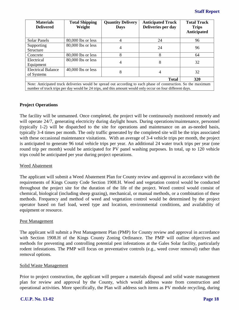
Staff Report
C.U.P. No. 13-02 Page 18
Materials Delivered
Total Shipping Weight
Quantity Delivery Days
Anticipated Truck Deliveries per day
Total Truck Trips
Anticipated
Solar Panels 80,000 lbs or less 4 24 96 Supporting Structure
80,000 lbs or less
4
24
96 Concrete 80,000 lbs or less 8 8 64 Electrical Equipment
80,000 lbs or less
4
8
32 Electrical Balance of Systems
40,000 lbs or less
8
4
32
Total 320 Note: Anticipated truck deliveries would be spread out according to each phase of construction. So the maximum number of truck trips per day would be 24 trips, and this amount would only occur on four different days.
Project Operations The facility will be unmanned. Once completed, the project will be continuously monitored remotely and will operate 24/7, generating electricity during daylight hours. During operations/maintenance, personnel (typically 1-2) will be dispatched to the site for operations and maintenance on an as-needed basis, typically 3-4 times per month. The only traffic generated by the completed site will be the trips associated with these occasional maintenance visitations. With an average of 3-4 vehicle trips per month, the project is anticipated to generate 96 total vehicle trips per year. An additional 24 water truck trips per year (one round trip per month) would be anticipated for PV panel washing purposes. In total, up to 120 vehicle trips could be anticipated per year during project operations. Weed Abatement The applicant will submit a Weed Abatement Plan for County review and approval in accordance with the requirements of Kings County Code Section 1908.H. Weed and vegetation control would be conducted throughout the project site for the duration of the life of the project. Weed control would consist of chemical, biological (including sheep grazing), mechanical, or manual methods, or a combination of these methods. Frequency and method of weed and vegetation control would be determined by the project operator based on fuel load, weed type and location, environmental conditions, and availability of equipment or resource. Pest Management The applicant will submit a Pest Management Plan (PMP) for County review and approval in accordance with Section 1908.H of the Kings County Zoning Ordinance. The PMP will outline objectives and methods for preventing and controlling potential pest infestations at the Gales Solar facility, particularly rodent infestations. The PMP will focus on preventative controls (e.g., weed cover removal) rather than removal options. Solid Waste Management Prior to project construction, the applicant will prepare a materials disposal and solid waste management plan for review and approval by the County, which would address waste from construction and operational activities. More specifically, the Plan will address such items as PV module recycling, during
Staff Report
C.U.P. No. 13-02 Page 19
the decommission phase of the project; PV module disposal, in the event that modules are damaged during shipping or decommissioning of the project; waste reduction goals; and disposal locations. PROJECT REVIEW: May 1, 2013 Application submitted April 23, 2014 Application certified complete April 26, 2014 Begin 30-day review period for environmental review May 27, 2014 30-day environmental review period ends June 2, 2014 Planning Commission hearing STAFF ANALYSIS: In order to approve this permit, the Commission is first required to
find that:
• The use conforms to the policies of the General Plan.
• The use should not be detrimental to public health and safety, nor materially injurious to properties in the vicinity.
• The use will comply with applicable provisions of the
Ordinance. With regard to these required findings, staff comments that: 1. The proposed Project, as recommended for approval, is consistent with the objectives and the
policies of the 2035 Kings County General Plan, specifically:
A. Figure LU-16, the Kings County Land Use Map, of the Land Use Element of the 2035 Kings County General Plan designates this site as General Agriculture (AG-20).
B. Page LU-13, Section III.A.1 of the “Land Use Element” of the 2035 Kings County General Plan states that agricultural land use designations account for a vast majority of the County’s land use. Included within this land use type are four agricultural type land use designations, Limited Agriculture, General Agriculture 20 Acre Minimum, General Agriculture 40 Acre Minimum, and Exclusive Agriculture. The major differences between the four Agriculture designations relate to minimum parcel size, animal keeping, and agricultural service businesses. These designations preserve land best suited for agriculture, protect land from premature conversion, prevent encroachment of incompatible uses, and establish intensity of agricultural uses in a manner that remains compatible with other uses within the County. The development of agricultural service and produce processing facilities within the Agricultural areas of the County shall develop to County standards.
C. Page LU-13, Section III.A.1. of the “Land Use Element” states that the AG-20 designation is applied to rural areas of the county north of Kansas Avenue, excluding the Urban Fringe areas of Hanford and Lemoore, Communities of Armona and Home Garden, the Naval Air Station Lemoore, the Santa Rosa Rancheria Tribal Trust Land, and other small Rural Interface pockets of urban uses. Generally characterized by extensive and intensive agricultural uses, farms within this designation have historically been smaller in size. These areas should remain reserved for commercial agricultural uses because of their high quality

Staff Report
C.U.P. No. 13-02 Page 20
soil, natural and manmade waterways, scenic nature with larger concentrations of orchards, vineyards, and valley oak trees.
D. Page LU-27, Section IV.B of the “Land Use Element” of the 2035 Kings County General Plan states that the physical development of agricultural properties is regulated and implemented by the zoning ordinance.
E. Page LU-38, LU Goal B7 of the “Land Use Element” of the 2035 Kings County General Plan states that community benefiting non-agricultural uses remain compatible within the County’s Agriculture Open Space area, and are supported for their continued operation and existence.
F. Page LU-38, LU Policy B7.1.3 of the “Land Use Element” of the 2035 Kings County General Plan states that power generation facilities for commercial markets shall be allowed and regulated through the Conditional Use Permit approval process, and include thermal, wind, and solar photovoltaic electrical generating facilities that produce power.
G. Page RC-50, Section G, Objective G1.2 of the “Resource Conservation Element” states that the County will promote the development of sustainable and renewable alternative energy sources, including wind, solar, hydroelectric and biomass energy.
H. Page RC-50, Section G, Policy G1.2.2 of the “Resource Conservation Element” states the County will encourage and support efforts to develop commercial alternative energy sources in lower priority agricultural lands within Kings County, when appropriately sited.
I. Page RC-51, Section G, Policy G1.2.7 of the “Resource Conservation Element” states the County will require commercial solar and wind energy systems to be reviewed as a conditional use permit pursuant to the procedures of the Kings County Zoning Ordinance.
2. The use should not be detrimental to public health and safety, nor materially injurious to properties
in the vicinity. A Mitigated Negative Declaration has been recommended for this Project. The proposed Project may have significant adverse impacts on the environment; however, those impacts can be mitigated to an insignificant level by implementing the Mitigation Monitoring and Reporting Plan attached to the Planning Commission Resolution for this project as Exhibit “A.” On the bases of the whole record (including the initial study and all comments received), there is no substantial evidence that the project will have a significant effect on the environment. The Mitigated Negative Declaration reflects the Planning Commission’s independent judgment and analysis.
3. The use complies with the applicable provisions of the ordinance, specifically: The proposed
Project, as recommended for approval, is consistent with the Kings County Zoning Ordinance. A. Article 4, Section 402.D.21 of the General Agricultural (AG-20) District lists solar
photovoltaic electrical generating facilities that commercially produce power for sale, which comply with all local, regional, State, and Federal regulations as a conditional use subject to Kings County Planning Commission approval.
B. Article 19, Section 1908.H of the Kings County Zoning Ordinance states that the when an application is submitted for a solar photovoltaic electrical facility for commercial sale and distribution of electrical power, the following findings shall be made before granting a conditional use permit: (1) The proposed site is located in an area designated as either “Very Low Priority,”
“Low Priority,” or “Low-Medium Priority” land according to Figure RC-13 Priority Agricultural Land (2035 Kings County General Plan, Resource Conservation

Staff Report
C.U.P. No. 13-02 Page 21
Element, Page RC-20). “Medium Priority” land may be considered when comparable agricultural operations are integrated, the standard mitigation requirement is applied, or combination thereof. a. As shown in Figure 7 of the Initial Study/Mitigated Negative Declaration
(IS/MND), the Gales Solar site is designated Medium Priority Land. Cancellation of the existing FSZ contract on project land (for which Mitigation Measure II-3 has been proposed) requires the purchase or acquisition of off-site agricultural mitigation land at the appropriate ratio (1:1) for the life of the project. If FSZ contract cancellation does not occur, project option 2 would be implemented, which involves integrating comparable agricultural operations with the proposed solar use (see the Agriculture and Forest Resources Section of IS/MND for discussion).
(2) The proposed site is located within 1 mile of an existing 60-kV or higher utility electrical line. a. The proposed site is located immediately adjacent to a 12kV utility
“distribution” electrical line, to which the project will directly interconnect via a “line tap.” A smaller, distributed-level solar power plant such as the Gales 3MW project can and preferably does connect to a distribution line rather than the larger 60kV transmission (or sub-transmission) lines. Connecting to a larger capacity transmission line is significantly more costly, is not a requirement for projects of this size, and typically is not done due to project economics. In addition, it should be noted that a 115kV line runs in a north-south direction along the west side of 7th Avenue.
(3) Agricultural mitigation is proposed for every acre of Prime Farmland, Unique Farmland, or Farmland of Statewide Importance converted for a commercial solar facility. The agricultural mitigation shall preserve at a ratio of 1:1 an equal amount of agricultural acreage of equal or greater quality in a manner acceptable to the County that coincides with the life of the project. Agricultural mitigation on land designed “Medium-High” or higher priority land shall preserve an equivalent amount of agricultural acreage at a ratio of 2:1. a. See the discussion for Finding 3.B.(1) above.
(4) The project includes a reclamation plan and financial assurance acceptable to the County that ensures the return of the land to a farmable state after completion of the project life, and retains surface water rights. a. The project would provide a reclamation plan and financial assurance
acceptable to the County prior to issuance of construction permits. The reclamation plan and financial assurance ensures the removal of all project fixtures, equipment, and non-agricultural roads, and will require restoration of compacted soil after completion of the project life. The land would retain water rights; therefore, water rights would not have to be replaced.
(5) The project includes a pest management plan and weed abatement plan to protect adjacent farmland from nuisances and disruption. a. The project would provide a pest management plan and weed abatement
plan to protect adjacent farmland from nuisances and disruption prior to issuance of construction permits. The weed abatement plan would ensure that combustible vegetation or agricultural products on and around the project boundary would be actively managed by the project owner or its affiliates during both the construction and operation phases of the project to
Staff Report
C.U.P. No. 13-02 Page 22
minimize fire risk. Combustible products would be limited in height or removed through a combination of sheep grazing and mechanical equipment. Herbicides may be applied if warranted by site conditions as specified in the weed abatement plan. Additionally, the project would include fire breaks around the project boundary in the form of interior gravel driveways subject to County standards. The pest management plan would reduce anticipated nuisance impacts to adjacent farmland from pests inhabiting project facilities. Rodenticide and herbicide would be selected and used in a manner that minimizes impacts to protected biological species. The pest management plan would set action thresholds, identify pests, specify prevention methods as a first course of action, specify control methods as a second course of action, and establish a qualitative performance goal of nuisance reduction to adjacent farmland.
(6) The project establishes internal access roads that do not exceed a maximum distance of 300 feet between lanes. a. The project establishes internal access driveways that do not exceed a
maximum separation distance of 300 feet from edge of driveway to edge of driveway.
(7) The project includes a solid waste management plan for site maintenance and disposal of trash and debris. a. The project would provide a solid waste management plan for site
maintenance and disposal of trash and debris prior to issuance of construction permits.
(8) The project site is located on Williamson Act or Farmland Security Zone contracted land, unless it meets the principles of compatibility under Government Code Section 51238.1(a). Otherwise, the contract is proposed for cancellation or is eligible and converts to a Solar Easement. a. As discussed in detail in the Project Description section and Agriculture and
Forest Resources section of the IS/MND, the applicant would implement one of two options with respect to the site’s existing Farmland Security Zone contract. [1] Option 1: The first option proposes cancellation of the existing FSZ
contract. Under this option agricultural operations would be discontinued on the site during the lifetime of the project. The temporary use of the land for solar development would represent a very small portion of the overall, currently designated farmland in Kings County, as well as of the total amount of land within FSZ Contract No. 00011 (approximately 5 percent). Temporarily (i.e. for the lifetime of the project) removing the project site from agricultural production would have the potentially adverse impact of converting “Farmland of Statewide Importance” to nonagricultural use. Implementation of Mitigation Measures II-1, II-2 and II-3 would reduce this impact to a less-than-significant level by requiring agricultural operations off-site, (i.e. on mitigation land), soil reclamation and associated financial assurances.
Staff Report
C.U.P. No. 13-02 Page 23
[2] Option 2: If FSZ cancellation is unsuccessful, this project option would consist of solar generation along with continued on-site agricultural operations. Under this option, the applicant would prepare and implement, during the operational life of the project, an Agriculture Management Plan (AMP) that completely satisfies the Williamson Act principles of compatibility and the performance standards established in Government Code Section 51238.1. Under this option, a “continuous agricultural area” would be cultivated with strawberries, sweet corn, and/or melons, to produce an equivalent or greater economic output than the entire parcel has historically yielded, with the remainder of the project lease parcel to be utilized for sheep grazing/husbandry, as discussed below, in order to produce an equivalent or greater productivity output compared to the site’s historical output. If the second option is selected then the use will not significantly compromise the long-term productive agricultural capability of the subject contracted parcel or on other contracted lands in agricultural preserves. If continued agricultural operations can yield equivalent economic and productivity return as compared to existing (pre-project) conditions the project could still have potential adverse impacts by conversion of “Farmland of Statewide Importance” to a non-agricultural use, but only if long-term production on the site is significantly compromised by not reclaiming the soil and/or a lack of financial assurances. Implementation of Mitigation Measures II-1 and II-2 would reduce this impact to a less-than-significant level by requiring soil reclamation after the life of the project via financial assurances. Government Code Section 51238.1. (a) Uses approved on contracted lands shall be consistent with all of the following principles of compatibility: (a) The use will not significantly compromise the long-term,
productive agricultural capability of the subject contracted parcel or parcels or on other contracted lands in agricultural preserves. 1) The applicant’s proposed alternative to cancellation
of the Farmland Security Zone contract on the property contemplates, in addition to sheep grazing/husbandry within the solar arrays, the continued farming operations on a portion of the 22-acre solar lease area with high value crops to produce an equivalent, overall economic and productivity return as has historically existed on the subject property. A ten-year history of the average

Staff Report
C.U.P. No. 13-02 Page 24
agricultural economic output for the project site is shown in Table 1 below.
Table 1
Project Site Cropping History and County Data
Crop
Year Subject Property
Production (Tons Per Acre) and
Value
King’s County Data1
Harvested Acreage –
Total Kings County
Production (Tons) Per
Acre
County Average
Value per Ton
Value per Acre per
Year
Corn Silage
2012 Similar to county averages
58,243 25.94 $49.50 $1,284.03 2011 57,220 25.92 $48.60 $1,259.71
20102 56,745 26.06 $34.60 $ 901.68 20092 63,232 26.99 $25.70 $ 693.64 2008 73,944 27.00 $48.10 $1,298.70 2007 55,383 26.96 $33.00 $889.68 2006 66,875 26.04 $24.00 $624.96 2005 65,502 25.30 $27.30 $690.69 2004 55,233 23.22 $25.00 $580.50 2003 50,298 24.63 $21.36 $526.10
Ten Year Average 54,443 23.19 $28.77 $745.83 Wheat Silage
2012 Similar to county averages
57,489 15.75 $40.40 $636.30 2011 57,220 15.89 $39.60 $629.24
2010
48,883
17.29
$25.70
$444.35
2009 54,233 17.86 $21.90 $391.13 2008 57,727 17.80 $39.10 $695.98 2007 32,540 18.53 $26.00 $481.78 2006 38,318 14.72 $23.00 $338.56 2005 40,675 13.92 $22.30 $310.42 2004 25,756 13.80 $21.00 $289.80 2003 20,788 13.81 $18.61 $257.00
Ten Year Average 43,363 15.94 $27.76 $447.46 Income per Acre per Year Assuming Two Crops Per Year $1,193.29
Income per 22-Acre Lease Parcel per Year of Combined Crops Averages $26,253.26 1. Source: Kings County Department of Agriculture, Measurement Standards and Kings County
Agricultural Commissioner 2. Alfalfa grown at subject property for half of 2009 and 2010; the average yield and monetary value per
acre for alfalfa is similar to (and slightly lower than) corn silage so not listed out separately.
Table 1 indicates that the combined “double crop” average (e.g., two crops are typically grown per year) of both crops historically grown (primarily corn and wheat silage) has yielded $1,193.29/acre/year over

Staff Report
C.U.P. No. 13-02 Page 25
the past ten years, or approximately $26,253.26/year for the entire 22-acre lease parcel. As shown in Table 2, use of even a 1-acre portion of the 22-acre lease area for high value seasonal crops, such as strawberries, sweet corn, and/or melons can produce an equivalent or greater economic return than the entire parcel has historically yielded. The tentative proposal for the continued agricultural use of the subject property under Option 2 is therefore the following: [a] While the solar farm is being constructed in
the southern 20-acre portion, prepare a 2-acre portion of the site for high-value crop production in the northernmost two acres of the 22-acre lease area.
[b] Following construction of the solar farm and
the filing of a Notice of Termination of coverage under the California NPDES General Permit (for discharges of storm water associated with construction activity), plant high-value crops within the first three years of operation in the 4.5-acre area shown on Figure 5.
[c] In addition to the planting of high-value crops
on the 4.5-acre area described above, sheep grazing/husbandry activities would be performed on the remainder of the project lease area, in-between and beneath the solar panel structures. As the expected annual income of sheep grazing/husbandry is highly variable and depends on many factors, the expected income is not included in this analysis.
The productivity and economic yields shown in Table 2 are based on ten-year historical California averages. There is a potential for even higher yields on the subject property by using enhanced farming methods or specialty techniques, including hydroponic growing methods, multi-species “co-farming”, locally-produced (“farm-to-table”) product marketing, organic produce, and/or rotation of crops in seasonal or popular demand. Drip-irrigation

Staff Report
C.U.P. No. 13-02 Page 26
techniques are proposed for all alternate crops to address water availability and conservation issues12. Hydroponic crops require less water and soil-less gardening eliminates weeds while reducing or eradicating soil-borne pests and diseases.
Table 2 Proposed Alternative Crops for Gales Solar Site
Proposed Alternative
High-Value Crop
Yield
(tons per acre)
Price
(per ton)
Future Annual Expected Total Financial Yield (1 Acre Out of 22-Acre Lease
Parcel)1
Future Annual Expected Total Financial Yield (4 Acres out of 22-Acre Lease
Parcel)
Historical Average Annual Total Financial
Yield (Entire 22-Acre Lease Parcel)
Vertical (hydroponic) Strawberries
282
$1,3002,3
$36,400
$145,600
$26,253.26
Traditionally Farmed Strawberries3
7.5
$1,300
$9,750
$39,000
Sweet Corn4
8.9
$432
$3,8005
$15,200
Pumpkins/ Specialty Melons and Squash6
14
$240
$3,3607
$13,440
1. Total financial yield conservatively assumes only one acre of production on entire 22-acre parcel – this number is expected to go as high as 15 acres depending on water availability, ultimate site design and demand for agricultural products produced.
2. Conservatively assumes half of yield seen in other areas of California (28 instead of 56 tons/acre), and uses California ten-year average price of $0.65/lb., however price is viewed as conservative as locally marketed strawberries have been shown to be sold as high as $3/lb. Source: http://www.greentechmedia.com/articles/read/the-farm-of-the-future-will-grow-plants-vertically-and- hydroponically
3. Minimum acreage to be grown would likely be an average of 4 acres totaling $39,000/year for the 4-acre portion of the lease parcel. Assumes California ten year average (2003-2012) yield of 7.5 tons/acre and $0.65/pound price for fresh strawberries. Source: Kings County Agricultural Commissioner and http://usda.mannlib.cornell.edu/MannUsda/viewDocumentInfo.do?documentID=1381
4. Assumes California ten year average (2000-2009) yield of sweet corn 8.9 tons per acre and price of $432/ton. Source: http://usda.mannlib.cornell.edu/MannUsda/viewDocumentInfo.do?documentID=1564
5. Minimum acreage to be grown would likely be an average of 4 acres totaling $15,200/year for the 4-acre portion of the lease parcel.
6. Assumes California one year (2013) average for pumpkins of 14 tons per acre and 2012 average of $240/ton. Other types of high value squash and melons can also be grown to meet local/specialty market demand. Source: http://www.ers.usda.gov/topics/in-the-news/pumpkins-background-statistics.aspx#.UnEF10rD-70%20
7. Minimum acreage to be grown would likely be an average of 4 acres totaling $13,440/year for the 4-acre portion of the lease parcel.
An Agriculture Management Plan for the project (prepared under option 2) would ensure maintenance of sustainable, agricultural commercial operations on the site throughout the life of the project. Implementation of a Soil Reclamation Plan would return the entire 22-acre solar project site to

Staff Report
C.U.P. No. 13-02 Page 27
pre-project conditions following site decommissioning. It should be reiterated that the project site constitutes only approximately 5 percent of the total 517-acre area of FSZ Contract No. 00011 and less than one-half of one percent of FSZ contracted land in Kings County.
(b) The use will not significantly displace or impair current or reasonably foreseeable agricultural operations on the subject contracted parcel or on other contracted lands in agricultural preserves. 1) To remain Williamson Act compatible and to be in
compliance with the project’s conditional use permit, the owner/operator would fully commit to and ensure successful implementation of an Agriculture Management Plan, consistent with the principles of compatibility and performance standards outlined in Government Code section 51238.1. Alternative agricultural operations proposed at the project site for the life of the project would yield a similar or increased, overall economic and productivity return as has historically existed on the subject property (see Tables 1 and 2 above). As shown on both the fixed-tilt and tracking Site Plans, a 4.5-acre “Continuous Agricultural Area” for high-value crops has been incorporated into the site design. This represents approximately 20% of the total 22-acre lease area. In addition, sheep grazing/husbandry activities are proposed on approximately 16.5 acres of the remaining acreage (or a total of almost 95% of the remaining site footprint). The development and operation of the Gales Solar site is self-contained, does not include elements that would facilitate expansion (i.e., over-sized infrastructure), nor does the operation of the project pose harm or create issues of incompatibility with the operation of agricultural activities on adjacent properties. Furthermore, the project site constitutes only approximately 5 percent of the total 517-acre area of FSZ Contract No. 00011.
(c) The use will not result in the significant removal of adjacent contracted land from agricultural or open-space use.

Staff Report
C.U.P. No. 13-02 Page 28
1) The site is surrounded by lands containing FSZ and Williamson Act contracts, with the single exception of the small rural residential area north of the project site, consisting of four homes. The project site constitutes only approximately 5 percent of the total 517-acre area of FSZ Contract No. 00011 and less than one-half of one percent of FSZ contracted land in Kings County. It would be speculative to assume that the introduction of a 22-acre solar facility on the project site would lead to removal of adjacent contracted land from agricultural or open space use for similar purposes. The project would be self-contained and would not provide new available infrastructure that could be used by other power generation projects. Moreover, a low likelihood exists for the demand of additional energy projects on nearby farmland, as locating these types of “distributed level” renewable energy projects is physically limited to the (low) capacity on a given electrical distribution line. That is, it is unlikely that additional solar farms can physically be placed in the vicinity due to physical limits to carry electricity on the power lines. Therefore, the proposed use will not induce additional solar generation facilities to site on adjacent parcels. In addition, the solar facility is not an intensive use that would create conflicts with neighboring agricultural operations on contracted lands and somehow lead to the inability of adjacent landowners to continue farming.
If the DOC approves the applicant’s request for cancellation of the existing Williamson Act/FSZ contract for the 22-acre lease area, then the project would not conflict with an existing Williamson Act contract. If the DOC does not approve cancellation of the FSZ contract, then the applicant would conduct on-site agricultural operations that would be consistent with the principles of compatibility of California Government Code Section 51238.1, as discussed above in Project Option 2 – Continue Agricultural Operations On-site. By doing so, the project would not conflict with the existing Williamson Act contract over the property.

Staff Report
C.U.P. No. 13-02 Page 29
STATEMENT OF FINDINGS OF CONSISTENCY: 1. LAND CONSERVATION (WILLIAMSON) ACT FINDINGS:
A. The project site (APN: 014-090-033) is located within an established agricultural preserve and is
restricted by a Farmland Security Zone Contract. See Finding 3.B.(8) above for Land Conservation (Williamson) Act Consistency Findings.
2. FLOOD PLAIN FINDINGS:
A. The site is within Other Areas Zone X as shown on the National Flood Insurance Program, Flood Insurance Rate Map (FIRM), Map Number 06031C0205C, dated June 16, 2009. There are no development restrictions associated with Other Areas Zone X since these are areas determined to be outside the 0.2 percent annual chance floodplain.
3. ENTERPRISE ZONE FINDINGS:
A. The project site is not located within the Kings County Enterprise Zone. 4. AIRPORT COMPATIBILITY ZONE FINDINGS:
A. The project site is not located within an Airport Compatibility Zone. 5. SEPTIC SYSTEM FINDINGS:
A. The Project site is not located within an area requiring engineering for any new septic systems that are installed.
RECOMMENDATIONS: It is recommended that the Commission approve Conditional Use Permit No. 13-02 as described above and adopt Resolution No. 14-06. Approval of this Resolution will: 1. Find that the proposed project may have significant adverse impacts on the environment;
however, those impacts can be mitigated to an insignificant level by implementing the Mitigation Monitoring and Reporting Plan attached to the Planning Commission Resolution as Exhibit “A,” and approves a Mitigated Negative Declaration.
2. Find that the project is consistent with the Kings County General Plan, Kings County Zoning
Ordinance, and the California Land Conservation Act of 1965 (Williamson Act). 3. Approve the project with specified conditions of approval. This permit shall become effective upon the expiration of eight (8) days following the date on which the permit was granted unless the Board of Supervisors shall act to review the decision of the Planning Commission. For the information of the applicant, compliance with other adopted rules and regulations of any local or state regulatory agency shall be required by the Planning Commission. This includes but is not limited to the following:

Staff Report
C.U.P. No. 13-02 Page 30
KINGS COUNTY COMMUNITY DEVELOPMENT AGENCY – PLANNING DIVISION: Contact Sandy Roper of the Kings County Community Development Agency at (559) 852-2685 regarding the following requirements: 1. All proposals of the applicant shall be conditions of approval if not mentioned herein. 2. Prior to initiation of construction, the applicant shall conduct a site visit in concert with the
Cultural Department of the Santa Rosa Rancheria in order to provide an opportunity for the Rancheria to assess the site and discuss their recommendations. During the site visit a cultural sensitivity class will be taught by the Cultural Department of the Santa Rosa Rancheria for the construction crew. Prior to initiation of construction, the applicant shall consult with the Cultural Department of the Santa Rosa Rancheria to determine if they would like to provide one Tribal Cultural Consultant (TCC) during project grading. The Applicant and the Santa Rosa Rancheria shall enter a reburial agreement as well as a curation agreement for any artifacts that may be discovered during construction (per CEQA Guidelines, California Code of Regulations, Title 14, Section 15064.5). If prehistoric artifacts are found, the project archaeologist will work with the TCC to determine their significance and work with the Cultural Department of the Santa Rosa Rancheria and the landowner to identify potential reburial options, as requested by the Tribe in their February 21, 2013 letter.
3. The site plan for the project is approved in concept. However, it is understood that during the actual design of the project that either of the following minor alterations to the site plan may be necessary: 1) structural alterations; and/or 2) alterations to the location of structures. Any minor alterations shall comply with the following requirements:
A. The site shall be developed in substantial compliance with the conceptually approved site
plan. Development of the site shall be considered substantially consistent with the approved conceptual site plan if any minor structural alteration is within ten (10) percent of the square footage shown on the conceptually approved site plan or up to a 2,500 square foot increase in structural size, whichever is less, and the minor structural alteration complies with coverage standards.
B. A minor alteration of the location of a structure shall be considered substantially consistent with the approved conceptual site plan if the new location of the structure complies with all setback requirements for the zone district that the project site is located in.
C. Any minor alteration that would make it necessary to modify or change any condition of approval placed on the project would require resubmittal of the application to amend the approval of the Conditional Use Permit.
D. No expansion of use, regardless of size, which would increase the projected scale of operations beyond the scope and nature described in this Conditional Use Permit application, will be allowed. Any expansion that is a substantial change from the conceptually approved site plan, will require either an amendment to the approved Conditional Use Permit or a new zoning permit.
4. The development shall comply with all regulations of Zoning Ordinance No. 269, with particular
reference to the General Agricultural (AG-20) Zone District standards contained in Article 4. 5. Pursuant to Section 1605.B.1.a.1 of the Kings County Zoning Ordinance, No solid fence, wall,
hedge or shrub exceeding three (3) feet in height shall be erected, planted or maintained within a

Staff Report
C.U.P. No. 13-02 Page 31
required Traffic Safety Visibility Area. Traffic Safety Visibility Area is defined as a space set aside on a lot in which all visual obstructions, such as structures, fences and plantings that inhibit visibility and thus have the potential to cause a hazard to traffic and pedestrian safety are prohibited, as follows: a. Area adjacent to a driveway on any lot - the Traffic Safety Visibility Area is that area on
the street side of a diagonal line connecting points, measured from the intersection of the driveway (located on the property or adjoining parcel) and the street right of way line, twenty (20) feet along the side of the driveway and twenty (20) feet along the street side of a lot.
b. On a corner lot - the Traffic Safety Visibility Area also includes that area of a corner lot on the street side of a diagonal line connecting points, measured from the property corner where the streets intersect, set back one (1) foot for every one (1) mile per hour of the posted speed limit along each street.
6. Pursuant to Section 1606.C.1 of the Kings County Zoning Ordinance unless otherwise stated, the
following signs are allowed as a permitted use and do not require a sign permit, site plan review or conditional use permit. All signs shall be located outside of the public right-of-way and shall not be located within a traffic safety visibility area if over three (3) feet in height. Unless a different setback is specified for a particular zone district, the minimum setback distance for all signs over three (3) feet in height shall be ten (10) feet from property lines. Signs shall be permitted only as follows in Agricultural (A) Districts:
A. Name plates or signs, not directly illuminated, with an aggregate area of not more than
forty (40) square feet pertaining to a permitted use, permitted use with site plan review or conditional use conducted on the site.
B. Signs exceeding forty (40) square feet in structural area and up to one-hundred-fifty (150) square feet in structural area which are incidental and pertaining to a permitted or conditional use may be permitted subject to a site plan review. Such signs may be located on the same parcel or an adjacent parcel used in conjunction with the permitted or conditional use. Signs exceeding forty (40) square feet in structural area may be illuminated and shall be thirty (30) feet from property lines adjacent to a road.
C. One non-illuminated on-site sign real estate sign or subdivision not exceeding thirty-two (32) square feet in structural area with copy on both sides pertaining to the sale, lease, rental or display of a structure or land per Section 1606.B.2.a.
D. Directional or information (other than advertising) signs not exceeding two hundred and forty (240) square feet in area located adjacent to a state highway or a county road within an area limited by points not closer than one-fourth (¼) mile or further than three-fourths (¾) mile from a frontage road turnoff, listing commercial establishments accessible via the frontage road, and further provided that not more than four (4) such signs shall be permitted on each side of the highway or county road.
E. Signs not exceeding two hundred forty (240) square feet in area located adjacent to a state highway or county road that is classified as an arterial or collector road (including such designations as urban or rural, major or minor) giving direction to or information about Kings County cities, communities, or rural service centers which are accessible by such state highways or county roads or direct routes consisting of combinations thereof, provided that such signs shall be limited to four (4) per city, community or rural service center regardless of the sign's location in this district, and further provided that such signs

Staff Report
C.U.P. No. 13-02 Page 32
shall not contain information pertaining to a subdivision of land or private development, commercial establishments or quasi-public developments.
F. Non-illuminated temporary construction signs in accordance with Section 1606.B.2.c. G. Political and Campaign Signs in accordance with Section 1606.B.3. H. Placing a sign on property which is restricted by contract under the California Land
Conservation “Williamson” Act of 1965 shall be prohibited, except for temporary signs (pursuant to Section 1606.B.2.a, c, and d), political and campaign signs (pursuant to Section 1606.B.4), and signs incidental to a permitted use, permitted use with site plan review, or conditional use which are consistent with the Uniform Rules for Agricultural Preserves in Kings County.
7. Exterior lighting shall be hooded so as to be directed only on site. 8. A minimum of four (4) off-street parking spaces shall be provided and that such parking shall be
installed in accordance with the Kings County Improvement Standards. 9. All parking areas, aisles, and driveways shall be surfaced and maintained so as to provide a
durable, dustless surface. Section 303.G. and Drawing 3036 of the Kings County Improvement Standards requires Cutback Asphalt over four (4) inches of Decomposed Granite under the “Rural Alternative.” (Note: The Kings County Zoning Administrator hereby reserves the right to require additional improvements to the parking area and driveway if at any time in the future the decomposed granite surface deteriorates and either a dust problem is created due vehicles driving on the decomposed granite surface, or a mud problem is created due to vehicles tracking mud onto County Roads.)
10. All open and unlandscaped portions of the lot shall be maintained in good condition, free from
weeds, dust, trash and debris. 11. The minimum yard requirements from property line to a structure shall be as follows:
A. The minimum front yard setback shall be either fifty (50) feet from the front property line or eighty feet from the center of the road, whichever is greater.
B. The minimum side yard setback shall be ten (10) feet from the side property line. C. The minimum rear yard setback shall be ten (10) feet from the rear property line.
12. The minimum distance between structures shall be ten (10) feet. 13. The applicant shall comply with all requirements of, and obtain any necessary permits from, the
San Joaquin Valley Air Pollution Control District (SJVAPCD). Questions concerning SJVAPCD requirements should be direct to Jessica Willis at (559) 230-5818.
14. The applicant shall comply with all requirements of, and obtain any necessary permits from, the
California Regional Water Quality Control Board (CRWQCB). Questions concerning CRWQCB requirements should be direct to David Sholes at (559) 445-6279.
15. The applicant shall comply with all adopted rules and regulations of the Kings County Public
Works Department, Fire Department, and the Environmental Heath Services Division of the Health Department, and all other local and state regulatory agencies.

Staff Report
C.U.P. No. 13-02 Page 33
16. Pursuant to Section 14-38(d) of the Kings County Code of Ordinances, a “Notice of Disclosure
and Acknowledgment of Agricultural Land Use Protection and Right to Farm Policies of the County of Kings” shall be signed, notarized, and recorded.
17. Pursuant to Section 66020(d)(1) of the California Government Code, the owner is hereby notified
that the 90-day approval period in which the applicant may protest the imposition of fees, dedications, reservations, or other exactions, begins on the date that Planning Commission Resolution No. 13-05 is adopted.
18. Sales or use tax may apply to business activities on the site. The applicant may seek written
advice regarding the application of tax to your particular business by writing to the nearest State Board of Equalization office. For general information, please call the Board of Equalization at 1-800-400-7115.
19. Prior to the issuance of a building permit, the applicant shall submit a Soil Reclamation Plan for
review and approval by Community Development Agency staff. The plan shall contain an analysis of pre-project baseline soil conditions, and shall contain specific measures to restore the soil to its pre-project condition, including removal of all fixtures, equipment, non-agricultural driveways, and restoration of compacted soil. Reclamation shall be completed within six months of the expiration of the use permit.
20. Prior to the issuance of a building permit, the applicant shall post a performance bond or similar
instrument to ensure completion of the activities under the Reclamation Plan. Financial assurances for the Reclamation Plan will be reviewed every 5 years by the Kings County Community Development Agency to determine if finances are sufficient to perform reclamation of the Project. The assurance must be adjusted if, during the five year review, finances are determined to be insufficient to perform reclamation of the Project.
21. Additional annual service impact fees affecting the Kings County Fire and Sheriff departments
will not be billed to the applicant. Instead, the applicant will be responsible to pay for services rendered by the two departments during times of emergency when services are provided.
22. All mitigation measures in the Initial Study/Mitigated Negative Declaration and the Mitigation
Monitoring and Reporting Plan that pertain to CUP No. 13-02 are adopted as conditions of this approval, and included in the Conditional Use Permit.
23. Within eight (8) days following the date of the decision of the Kings County Planning
Commission, the decision may be appealed to the Kings County Board of Supervisors. The appeal shall be filed with the Clerk of the Board of Supervisors.
23. This Conditional Use Permit shall lapse and shall become null and void three (3) years following
the date that the Conditional Use Permit became effective, unless prior to the expiration of three (3) years the proposed use has been established. A Conditional Use Permit involving construction shall lapse and shall become null and void three (3) years following the date that the Conditional Use Permit became effective, unless prior to the expiration of three (3) year a building permit is issued by the Building Official and construction is commenced and diligently pursued toward completion on the site that was subject of the Conditional Use Permit application.

Staff Report
C.U.P. No. 13-02 Page 34
24. This Conditional Use Permit may be renewed for additional periods of time, if an application (by
letter) for renewal of the Conditional Use Permit is filed with the Planning Commission prior to the permit’s expiration date.
OTHER AGENCY’S COMMENTS, STANDARDS, AND REGULATIONS: The following departments and agencies have provided comments, standards, and regulations concerning the proposed project. The Planning Commission has no authority to modify, amend, or delete any of these comments, standards, and regulations but lists them here as information to the applicant. Appeals for relief of other agency’s standards and regulations must be made through that department’s or agency’s procedures, not through the Zoning Ordinance procedures. However, the applicant shall comply with all adopted rules and regulations of the Kings County Public Works Department, Fire Department, and the Environmental Heath Services Division of the Health Department, and all other local and state regulatory agencies. Failure of the applicant to comply with all adopted standards and regulations of all other local and state regulatory agencies is a violation of this conditional use permit (see Planning Division Condition No. 15 above) and could result in revocation of this conditional use permit. KINGS COUNTY COMMUNITY DEVELOPMENT AGENCY - BUILDING DIVISION Contact Darren Verdegaal at the Kings County Community Development Agency - Building Division at (559) 852-2683, regarding the following comments: 1. Building permits must be obtained from the Building Division of the Kings County Community
Development Agency for any structures, plumbing, electrical, or mechanical work. 2. Failure to obtain a building permit for any structure, prior to commencing construction, which
requires a building permit, will result in the payment of a double fee. Payment of such double fee shall not relieve any person from fully complying with the requirements of Kings County Code of Ordinances, Chapter 5 in the execution of the work or from any other penalties prescribed therein.
3. A minimum of two (2) sets of plans and calculations signed by an architect or engineer licensed to
practice in the State of California shall be required for the proposed work. 4. All special inspection reports shall be provided to the Building Division prior to requesting a final
inspection. 5. The applicant is responsible for contacting the Building Division to request a final inspection of
the structures prior to occupying the structures and prior to startup of the operation. No building or structure shall be used or occupied until the Building Division has issued a Certificate of Occupancy.
6. All drive approaches and durable dustless surfaces shall be installed prior to the final inspection
and maintained as per County Standards. 7. If the facility will have employees on-site for maintenance of the system an accessible restroom
shall be provided and shall comply with Section 1115B of the California Building Code. This may be accomplished by either construction of a permanent structure or use of a chemical toilet with a regular maintenance schedule.

Staff Report
C.U.P. No. 13-02 Page 35
8. Pursuant to Section 1129B of the California Building Code one (1) van accessible parking space, allowing room for individuals in wheelchairs, on braces or crutches to get in and out of an automobile onto a level surface, suitable for wheeling and walking shall be provided. The parking space shall be 9’ x 20’ with an 8’ wide loading and unloading aisle placed on the side opposite the driver’s side. The surfacing of the parking space, loading and unloading aisle and the accessible path from the space to the entrance of the building shall be either asphalt concrete or concrete.
9. The development shall comply with all applicable Americans with Disability’s Act (ADA)
requirements, especially Section 1127B of the California Building Code, which states that site development and grading shall be designed to provide access to all entrances and exterior ground-floor exits, and access to normal paths of travel. The accessible route of travel shall be the most practical direct route between accessible building entrances, accessible site facilities and the accessible entrance to the site, including but not limited to access from the accessible parking space to accessible building entrances.
10. A soils report, prepared by a qualified soils engineer, shall be provided to the Building Division
prior to issuance of building permits. 11. The facility shall meet the requirements of the State of California Model Water Efficient
Landscape Ordinance. Landscape and irrigation plans shall be provided to the Community Development Agency for review and approval prior to building permit issuance.
12. All construction shall conform to the 2013 California Code of Regulations Title 24 which consist
of the California Building Code, California Electrical Code, California Mechanical Code, California Plumbing Code, and California Energy Code, California Fire Code and California Green Building Standards Code.
KINGS COUNTY PUBLIC WORKS DEPARTMENT Contact Mike Hawkins of the Kings County Public Works Department at (559) 852-2708 regarding the following requirements: 1. All requirements required hereafter shall conform to the Kings County Improvement Standards. 2. All other alternatives to Public Works requirements must be approved by the Kings County Public
Works Department. 3. The applicant shall secure an encroachment permit for any work in the County right-of-way. 4. The applicant shall provide asphalt concrete drive approach(es).
5. Access to the site from a public road must be provided, and must be approved by the County. 6. Traffic ingress and egress shall be per the approved site plan. 7. Drive approach(es) shall be constructed in accordance with Section 205 of the Kings County
Improvement Standards and shall be 2.5” Asphalt-Concrete over 5” of Class II Base Rock. 8. Encroachment permits for drive approaches and other work in the right of way must be obtained
from the Public Works Department.

Staff Report
C.U.P. No. 13-02 Page 36
KINGS COUNTY FIRE DEPARTMENT: Contact Rick Smith of the Kings County Fire Department at (559) 852-2885 for the following comments: 1. Rows of solar panels shall not exceed 300 feet in length. 2. There shall be a minimum of 4 feet of separation between rows to allow access for fire suppression
personnel. 3. There shall be access roads of an all-weather surface capable of supporting heavy fire apparatus
between the 300 foot sections of solar panels to allow fire apparatus access to the panels so that no portion of any panel is greater than 150 feet from fire suppression access. The access roads shall be maintained and completely surround the solar panels to allow access from any side or end. Widths of access roads shall be determined by the Fire Marshal.
4. The solar field shall be kept clear of combustible weeds and debris. 5. The solar fields shall be protected to prevent public access. 6. Fire Department requires a Knox box or other approved system to store and secure keys for any
fence or buildings within the property. 7. Applicant shall provide training for fire personnel to be able to interrupt electrical power safely for
emergency incidents requiring fire suppression or rescue activities. 8. Architects, Engineers and Designers shall provide detailed plans for review of the project and shall
meet with the Fire Marshal in a timely manner upon his request for clarification of any issues. 9. Any fire suppression systems or fire flow requirements will be dependent upon project facilities
and review of the project specifications. 10. Fire Department reserves the right to add additional comments or requirements depending upon
the hazards involved with the project. KINGS COUNTY HEALTH DEPARTMENT: Contact Lee Johnson of the Kings County Department of Environmental Health Services at (559) 852-2631 regarding the following comments: 1. If hazardous materials at or above threshold reporting quantities (55 gallons of a liquid, 500
pounds of a solid, or 200 cubic feet of a gas) will be kept on site, the facility must file a Hazardous Materials Business Plan online at http://cers.calepa.ca.gov within 30 days of beginning operations. Hazardous materials are broadly defined, and include fuel, lubricants, antifreeze, motor vehicle batteries, welding gases, paints, solvents, glues, agricultural chemicals, etc. Please contact our office if you require assistance with the online registration process.

Staff Report
C.U.P. No. 13-02 Page 37
2. Any quantities of hazardous wastes generated by the facility operation must be managed in accordance with Federal, State, and local laws and regulations. Hazardous wastes cannot be disposed of into the municipal waste stream or onsite sewage disposal system. The owner/operator must contact our office at with any questions regarding proper management and reporting of any hazardous wastes associated with this operation.
3. Given the proximity of LNAS and frequent air traffic over the site, as well as adjacent highway
and road traffic, the sites must be designed and constructed so as to minimize light reflectivity that might be hazardous for aircraft or vehicles.
4. As per the Kings County Public Health Officer, Coccidiodes immiti, the fungus that causes valley fever, a serious and potentially long-term respiratory illness, is endemic in the soils of Kings County. Construction activities that disturb soils containing the spores of the fungus can put workers and the nearby public at risk. Effective dust control must be maintained on the job site at all times in order to reduce the risk of valley fever to workers and nearby residents. More information regarding the prevention of work related valley fever is available at www.cdph.ca.gov/programs/hesis/Documents/CocciFact.pdf and http://www.cdph.ca.gov/programs/ohb/Documents/OccCocci.pdf. Contact the San Joaquin Valley Air Pollution Control District for more information on dust control techniques.
PREPARATION: Prepared by the Kings County Community Development Agency (Sandy Roper) on May 23, 2014. Copies are available for review at the Kings County Community Development Department, Government Center, Hanford, California, or at the Kings County Clerk's Office, Government Center, Hanford, California. Attachments to the Staff Report:
1. Comments on the IS/MND 2. Responses to Comments 3. Erratum
H:\PLANNING\LAND DEVELOPMENT SECTION\ZONING ADMIN\CUP\2010 TO 2019\2013\CUP 13-02 GALES 3MW SOLAR PROJECT\PC REPORTS\CUP 13-02 PC STAFF REPORT.DOC


1
RESPONSES TO GALES SOLAR INITIAL STUDY/MITIGATED NEGATIVE DECLARATION COMMENTS
California Department of Fish and Game, May 21, 2014 Response to Comment 1-1 Aspen Environmental Group conducted a reconnaissance-level field survey of the project site on January 17, 2013. It is not uncommon to conduct reconnaissance-level surveys of project sites for CEQA purposes during such a time. These surveys are intended to identify whether a site provides suitable habitat for special-status species. Given that the Gales Solar project site is regularly disturbed via agricultural operations, Aspen Environmental Group determined that follow-up protocol-level surveys are not necessary. Notwithstanding this, the IS/MND includes Mitigation Measure IV-1 (see revised version in Response to Comment 1-3 below), which requires preconstruction surveys for migratory birds, burrowing owl, and San Joaquin kit fox. Response to Comment 1-2 As discussed on page 44 of the IS/MND, the project site does not contain any trees. As a result, there is no potential for Swainson’s hawk to nest on the project site. As a result, conducting Swainson’s hawk nesting surveys in accordance with the “Recommended Timing and Methodology for Swainson’s Hawk Nesting Surveys in California’s Central Valley” is not warranted. Response to Comment 1-3 Since the release of the Gales Solar IS/MND for public review, the County has made edits to Mitigation Measure IV-1 to ensure that this mitigation identifies protective measures that should be implemented in the event that burrowing owl are found nesting on-site prior to construction. As can be seen, this revised mitigation measure (MM IV-1(b)) now identifies the steps that should be taken if burrowing owl nest sites are found. The revised form of Mitigation Measure IV-1 is as follows:
MM IV-1(a) Migratory Birds. If project construction activities are proposed during the general bird breeding season (January 1 through September 15), a qualified biologist shall conduct a preconstruction nesting bird survey within 14 days of starting project-related activities. The preconstruction nesting bird survey shall cover suitable habitats within 250 feet of the project site. Additional nesting bird surveys shall be completed if project-related activities that could disturb nesting birds are delayed for 14 days or more. For project-related activities occurring outside of the general bird nesting season, no preconstruction nesting surveys are required. Written results of the preconstruction survey(s) shall be submitted to the Kings County Community Development Agency. Where the pre-

2
construction survey identifies active nests of protected bird species, exclusion areas will be marked with stakes and colored flagging tape will be maintained around all active nests until birds have fledged. Buffers from nesting birds shall be a minimum of 250 feet.
MM IV(b) Burrowing owl. A qualified biologist shall conduct a
preconstruction clearance survey for special-status species and migratory birds burrowing owl in all potential habitats throughout the project area; thus, any action that disrupts surface soils (e.g., clearing and grubbing, rough grading, excavation, compaction for temporary staging areas or permanent construction sites) shall be subject to a preconstruction survey. Surveys shall be undertaken not more than 30 days prior to ground disturbing activity to ensure avoidance during construction. All areas within 250 feet of the project area shall be surveyed where site access and visibility allows. Written results of the preconstruction survey shall be submitted to the Kings County Community Development Agency. If no special-status species or migratory birds are present burrowing owl are not detected, further mitigation is not necessary. If any special-status species and/or migratory birds burrowing owl are found nesting on-site, the biologist shall implement the following protective measures to ensure that animals are not adversely affected, and construction does not commence until the biologist has determined no harm would result to breeding animals as a result of construction. Written results of the preconstruction survey shall be submitted to the Kings County Community Development Agency.
If the preconstruction survey reveals the presence of burrowing owls during the nesting season (i.e., February 1 to August 31) and construction is to be initiated during the nesting season, then a qualified biologist shall observe the owls’ behavior to determine their breeding status. If the owls are breeding, no construction shall occur within 75 meters (250 feet) of any occupied burrow. Any construction planned within this 250-foot buffer zone shall be delayed until August 31, or until a biologist can document that affected nests are no longer occupied or that young have fledged and can be safely relocated, whichever occurs first. If occupied burrows are identified outside the breeding season or if a biologist determines during the breeding season that either the resident owls have not yet begun egg laying or incubation or that the juveniles are foraging independently and capable of

3
independent survival, then the project applicant may passively relocate the owls. Owls shall be excluded from any burrows within 50 meters (160 feet) of the direct impact zone by installing one-way doors in burrow entrances. One-way doors (e.g., modified dryer vents) shall be left in place 48 hours to insure owls have left the burrow before construction begins. If the survey reveals, either within 50 meters (160 feet) of the direct impact zone in the non-breeding season or within 75 meters (250 feet) of the direct impact zone in the breeding season, any unoccupied burrows, crevices, or holes made by other animals, which could provide habitat for burrowing owls, then access to these burrows shall be barred either through installation of one-way doors or through collapsing of the burrows prior to construction. After a thorough inspection, a qualified biologist shall determine whether the potential burrow can be safely collapsed or whether it may contain another resident species that requires relocation. By blocking burrowing owls’ access to these burrows, the applicant will ensure that no unsurveyed burrowing owls are adversely impacted by the project. For each occupied burrow rendered inaccessible during breeding season by construction and operation of the project, the project applicant shall provide two artificial burrows outside the 50 meter (160 foot) buffer zone. The project area shall be monitored daily for one week to confirm whether the owls are using their new, alternative burrows before construction begins. During construction, sections of flexible plastic pipe shall be inserted into occupied tunnels to maintain an escape route for any animals inside the burrows. If suitable nesting habitat is determined to be available on site, compensatory measures may be required to ensure that no undue impacts on nesting owl habitat occurs. Compensatory mitigation may be required by the CDFW as a precursor to granting authorization to evict owls during the breeding season from construction sites.
MM IV-1(c) San Joaquin Kit Fox. A qualified biologist shall conduct a preconstruction clearance survey for San Joaquin kit fox in all potential habitats throughout the project area; thus, any action that disrupts surface soils (e.g., clearing and grubbing, rough grading, excavation, compaction for temporary staging areas or permanent construction sites) shall be subject to a preconstruction survey. Surveys shall be undertaken not more than 30 days prior to ground disturbing activity to ensure avoidance during construction. All areas within 250 feet of the

4
project area shall be surveyed where site access and visibility allows. Written results of the preconstruction survey shall be submitted to the Kings County Community Development Agency. If kit fox are not detected, further mitigation is not necessary. If a den is discovered in the proposed disturbance footprint during the preconstruction survey, the following measures shall be implemented by a USFWS/CDFW-approved biologist:
1. The den shall be monitored for 3 days by a USFWS/CDFW-approved biologist, using a tracking medium or an infrared beam camera to determine if the den is currently being used.
2. Unoccupied dens shall be destroyed immediately to prevent subsequent use.
3. If a natal or pupping den is found, USFWS and CDFW shall be notified immediately. The den shall not be destroyed until the pups and adults have vacated, and then only after further consultation with USFWS and CDFW.
4. If kit fox activity is observed at the den during the initial monitoring period, the den shall be monitored for an additional 5 consecutive days from the time of the first observation to allow any resident animals to move to another den while den use is actively discouraged. For dens other than natal or pupping dens, use of the den can be discouraged by partially plugging the entrance with soil such that any resident animal can easily escape. Once the den is determined to be unoccupied it may be excavated under the direction of the biologist. Alternatively, if the animal is still present after 5 or more consecutive days of plugging and monitoring, the den may have to be excavated when, in the judgment of the biologist, the den is temporarily vacant (i.e., during the animal’s normal foraging activities).
In addition, prior to and during any ground-disturbing activities occurring within the project area during the construction phase, the applicant shall include the following protective measures in the construction plans for review and approval by the Community Development Agency, in accordance with the “U.S. Fish and Wildlife Service Standardized Recommendations for Protection of the Endangered San Joaquin Kit Fox Prior to or During Ground Disturbance” (2011):
1. Project-related vehicles should observe a daytime speed limit of 20-mph throughout the site in all project areas, except on county roads and State and Federal highways; this is particularly important at night when kit foxes are most active. Night-time construction should be minimized to the extent possible. However if it does occur, then the

5
speed limit should be reduced to 10-mph. Off-road traffic outside of designated project areas should be prohibited.
2. To prevent inadvertent entrapment of kit foxes or other animals during the construction phase of a project, all excavated, steep-walled holes or trenches more than 2-feet deep should be covered at the close of each working day by plywood or similar materials. If the trenches cannot be closed, one or more escape ramps constructed of earthen-fill or wooden planks shall be installed. Before such holes or trenches are filled, they should be thoroughly inspected for trapped animals. If at any time a trapped or injured kit fox is discovered, the Service and the California Department of Fish and Game (CDFG) shall be contacted as noted under measure 13 referenced below.
3. Kit foxes are attracted to den-like structures such as pipes and may enter stored pipes and become trapped or injured. All construction pipes, culverts, or similar structures with a diameter of 4-inches or greater that are stored at a construction site for one or more overnight periods should be thoroughly inspected for kit foxes before the pipe is subsequently buried, capped, or otherwise used or moved in any way. If a kit fox is discovered inside a pipe, that section of pipe should not be moved until the Service has been consulted. If necessary, and under the direct supervision of the biologist, the pipe may be moved only once to remove it from the path of construction activity, until the fox has escaped.
4. All food-related trash items such as wrappers, cans, bottles, and food scraps should be disposed of in securely closed containers and removed at least once a week from a construction or project site.
5. No firearms shall be allowed on the project site. 6. No pets, such as dogs or cats, should be permitted on the
project site to prevent harassment, mortality of kit foxes, or destruction of dens.
7. Use of rodenticides and herbicides in project areas should be restricted. This is necessary to prevent primary or secondary poisoning of kit foxes and the depletion of prey populations on which they depend. All uses of such compounds should observe label and other restrictions mandated by the U.S. Environmental Protection Agency, California Department of Food and Agriculture, and other State and Federal legislation, as well as additional project-related restrictions deemed necessary by the Service. If rodent control must be conducted, zinc phosphide should be used because of a proven lower risk to kit fox.

6
8. A representative shall be appointed by the project proponent who will be the contact source for any employee or contractor who might inadvertently kill or injure a kit fox or who finds a dead, injured or entrapped kit fox. The representative will be identified during the employee education program and their name and telephone number shall be provided to the Service.
9. An employee education program should be conducted for any project that has anticipated impacts to kit fox or other endangered species. The program should consist of a brief presentation by persons knowledgeable in kit fox biology and legislative protection to explain endangered species concerns to contractors, their employees, and military and/or agency personnel involved in the project. The program should include the following: A description of the San Joaquin kit fox and its habitat needs; a report of the occurrence of kit fox in the project area; an explanation of the status of the species and its protection under the Endangered Species Act; and a list of measures being taken to reduce impacts to the species during project construction and implementation. A fact sheet conveying this information should be prepared for distribution to the previously referenced people and anyone else who may enter the project site.
10. Upon completion of the project, all areas subject to temporary ground disturbances, including storage and staging areas, temporary roads, pipeline corridors, etc. should be re-contoured if necessary, and revegetated to promote restoration of the area to pre-project conditions. An area subject to "temporary" disturbance means any area that is disturbed during the project, but after project completion will not be subject to further disturbance and has the potential to be revegetated. Appropriate methods and plant species used to revegetate such areas should be determined on a site-specific basis in consultation with the Service, California Department of Fish and Game (CDFG), and revegetation experts.
11. In the case of trapped animals, escape ramps or structures should be installed immediately to allow the animal(s) to escape, or the Service should be contacted for guidance.
12. Any contractor, employee, or military or agency personnel who are responsible for inadvertently killing or injuring a San Joaquin kit fox shall immediately report the incident to their representative. This representative shall contact the CDFG immediately in the case of a dead, injured or entrapped kit fox. The CDFG contact for immediate

7
assistance is State Dispatch at (916)445-0045. They will contact the local warden or Mr. Paul Hoffman, the wildlife biologist, at (530)934-9309. The Service should be contacted at the numbers below.
13. The Sacramento Fish and Wildlife Office and CDFG shall be notified in writing within three working days of the accidental death or injury to a San Joaquin kit fox during project related activities. Notification must include the date, time, and location of the incident or of the finding of a dead or injured animal and any other pertinent information. The Service contact is the Chief of the Division of Endangered Species, at the addresses and telephone numbers below. The CDFG contact is Mr. Paul Hoffman at 1701 Nimbus Road, Suite A, Rancho Cordova, California 95670, (530) 934-9309.
14. New sightings of kit fox shall be reported to the California Natural Diversity Database (CNDDB). A copy of the reporting form and a topographic map clearly marked with the location of where the kit fox was observed should also be provided to the Service at the address below.
The request for protocol-level surveys for burrowing owls is noted. However, protocol-level surveys are not required for this project. During the reconnaissance-level survey performed on-site by Aspen Environmental Group, no active burrows, sign, or potential burrow sites were located. Given the low likelihood for burrowing owl to nest on-site as a result of ongoing agricultural disturbance, the preconstruction survey required in Mitigation Measure IV-1 would be sufficient to ensure that project construction would not adversely impact burrowing owls. CEQA does not compel compliance with CDFW’s survey guidelines as a matter of law (Association of Irritated Residents v. County of Madera (2003) 107 Cal.App.4th 1383). The survey guidelines are not codified in the Public Resources Code, the Fish and Game Code or the California Code of Regulations. CEQA does not require a lead agency to conduct every recommended test and perform all recommended research to evaluate the impacts of a proposed project. The fact that additional surveys might be helpful does not mean that they are required. (CEQA Guidelines, Section 15204, subd. (a)) Response to Comment 1-4 As shown in Response to Comment 1-2, the revised form of Mitigation Measure IV-1 requires the applicant to comply with the January 2011 U.S. Fish and Wildlife Service Standardized Recommendations for Protection of the Endangered San Joaquin Kit Fox Prior to or During Ground Disturbance. Response to Comment 1-5 In response to the comment, as shown in Response to Comment 1-2, Mitigation Measure IV-1 has been revised to clarify that the preconstruction survey for nesting birds shall be completed

8
within 14 days of construction if construction activities occur during the general bird breeding season (January 1 through September 15). Response to Comment 1-6 Once the preconstruction survey results are provided to the Kings County Community Development Agency (CDA), the CDA would forward the survey results to CDFW if any San Joaquin kit fox or burrowing owl are found nesting/denning on the project site.

Attachment No. 3
1
ERRATUM
for the
Gales Solar Project Initial Study/Mitigated Negative Declaration
June 2, 2014 Since the release of the Gales Solar Project Initial Study/Mitigated Negative Declaration (IS/MND) for public review, the Kings County Community Development Agency has determined that, for clarification purposes, certain changes to the IS/MND are warranted. As will be demonstrated below, none of the changes affect the adequacy of the environmental analysis, nor do they identify any significant new impacts, or present significant new information. As a result, per CEQA Guidelines Section 15073.5, recirculation of the Gales Solar IS/MND is not required.1 Changes to the Draft IS/MND text are presented in double-underlined format for new, added text and strikethrough format for deleted text. Agriculture and Forest Resources
Page 22 [Check mark for Question ‘b’] For Question ‘b’ in the Agriculture and Forest Resources section, a check mark was placed in the “Less Than Significant with Mitigation Incorporated” column of the CEQA Checklist. This inadvertent error has been corrected on page 22 to match the significance conclusion on page 33 by shifting the check mark to the “Less-Than-Significant Impact” column. Page 26 [Mitigation Measure II-1] Since release of the Gales Solar IS/MND for public review, the County has determined that MM II-1 should be amplified to be consistent with the level of detail included in similar mitigation measures placed on other solar projects within the County. As a result, Mitigation Measure II-1 on page 26 of the IS/MND is hereby revised as follows:
MM II-1: Soil Reclamation Plan. Prior to the issuance of a building permit, the applicant shall submit a Soil Reclamation Plan for review and approval by
1 According to CEQA Guidelines Section 15073.5,
(c) Recirculation is not required under the following circumstances: (1) Mitigation measures are replaced with equal or more effective measures pursuant to Section 15074.1. (2) New project revisions are added in response to written or verbal comments on the project’s effects
identified in the proposed negative declaration which are not new avoidable significant effects. (3) Measures or conditions of project approval are added after circulation of the negative declaration which
are not required by CEQA, which do not create new significant environmental effects and are not necessary to mitigate an avoidable significant effect.
(4) New information is added to the negative declaration which merely clarifies, amplifies, or makes insignificant modifications to the negative declaration.

Attachment No. 3
2
Community Development Agency staff. The plan shall contain an analysis of pre-project baseline soil conditions, and shall contain specific measures to restore the soil to its pre-project condition, including removal of all fixtures, equipment, non-agricultural driveways, and restoration of compacted soil. General preconstruction conditions of the project site shall be photographically documented by the applicant prior to the start of construction of the project. All road and other areas compacted during original construction or by equipment used in the decommissioning would be tilled to restore the sub-grade material to a density and depth consistent with its pre-project condition. A Kings County-approved grasses and forbs seed mixture designed to maximize revegetation with noninvasive species shall be broadcast or drilled across the project site, and weed-free mulch spread shall be applied, as needed, to stabilize the soil until germination occurs and young plants establish to facilitate moisture retention in the soil. Reclamation would return the site to the conditions equivalent to those prior to construction and operation of the project. Whether the project area has been restored to pre-construction conditions would be assessed by Kings County staff six months after the initial seeding has occurred. Additional seedings and applications of weed free mulch shall be applied to areas of the project site that have been determined to be unsuccessfully reclaimed (e.g., restored to pre-construction conditions) after six months, until the entire project area has been restored to equivalent conditions prior to construction and operation of the project. All waste shall be disposed of in compliance with applicable law. Waste would go to the Kings Waste and Recycling Authority’s Materials Recovery Facility in Hanford, where recyclable materials would be removed. All remaining waste would then go to the B-17 Landfill Unit at the Chemical Waste Management Kettleman Hills Facility. The B-17 Landfill unit has an approved capacity of 18.4 million cubic yards. The site capacity used as of March 2012 was 896,171 cubic yards. The site capacity remaining as of March 2012 was 17.5 million cubic yards. Conditional Use Permit No. 04-01, which approved a new non-hazardous-waste landfill designated as Landfill Unit B-17, was approved on May 30, 2006, when the Planning Commission adopted Resolution No. 06-05. The estimated closure date is 2052, depending on actual fill rate. If this facility is not available, another equivalent will be utilized. All waste associated with decommissioning will be disposed of or recycled in accordance with applicable laws. Additionally, the Soil Reclamation Plan shall discuss the retention of any surface water rights. Reclamation shall commence within two months of the expiration of the use permit, or abandonment of the solar use, and completed within 18 months from the date the facility ceases to operate.
The above changes serve to amplify Mitigation Measure II-1 of the Gales Solar IS/MND. The changes do not alter the conclusions of the IS/MND.

Attachment No. 3
3
Page 26 [Mitigation Measure II-2] MM II-2 on page 26 of the IS/MND is hereby revised for clarification purposes to specify additional methods of financial assurances.
MM II-2: Financial Assurance. Prior to the issuance of a building permit, the applicant shall either post a performance or cash bond, submit a Certificate of Deposit, or submit a letter of credit, or similar instrument to ensure completion of the activities under the Soil Reclamation Plan. Financial assurances for the Reclamation Plan will be reviewed every 5 years by the Kings County Community Development Agency to determine if finances are sufficient to perform reclamation of the project. The assurance must be adjusted if, during the five-year review, finances are determined to be insufficient to perform reclamation of the project.
The above changes to Mitigation Measure II-1 are for clarification purposes and do not affect the adequacy of the Gales Solar IS/MND. Page 30 [Question II ‘b’ discussion] The bottom paragraph on page 30 of the IS/MND is hereby clarified as follows:
The productivity and economic yields shown in Table 2 are based on ten-year historical California averages. There is a potential for even higher yields on the subject property by using enhanced farming methods or specialty techniques, including hydroponic growing methods, multi-species “co-farming”, locally-produced (“farm-to-table”) product marketing, organic produce, and/or rotation of other high-value crops (not shown in Table 2) in seasonal or popular demand. Drip-irrigation techniques are proposed for all alternate crops to address water availability and conservation issues. Hydroponic crops require less water and soil-less gardening eliminates weeds while reducing or eradicating soil-borne pests and diseases.
These minor changes do not affect the adequacy of the analysis contained in the Agriculture and Forest Resources section of the Gales Solar IS/MND. Air Quality Page 37 [Table 4] As indicated in Table 4 on page 37 of the IS/MND, the project’s unmitigated construction emissions would be well below the relevant San Joaquin Valley Air Pollution Control District thresholds. By “unimitigated”, it is meant that the best management practices (BMPs) listed on Page 36 of the IS/MND were not included in the construction emissions modeling performed for the project. However, out of an abundance of caution, the project has been conditioned to implement the erosion control BMPs listed on page 36 of the IS/MND. For clarification purposes, Table 4 on page 37 of the IS/MND is hereby revised as follows:

Attachment No. 3
4
Table 4 Maximum Unmitigated1 Project Construction-Related Emissions
Pollutant Project Emissions
(tons/yr) SJVAPCD Thresholds of Significance
(tons/yr) ROG 0.10 10 NOX 0.98 10 CO 0.79 100 SOX 0.00143 27 PM10 0.07 15 PM2.5 0.05 15
Source: CalEEMod, January 2014 (see Appendix A). 1 “Unmitigated” refers to the fact that the BMPs listed on page 36 have not been included in the construction emissions modeling performed for the project. As can be seen in this table, mitigation is not required to reduce the project’s construction emissions below the District’s relevant thresholds. Notwithstanding this, out of an abundance of caution, the BMPs listed on page 36 have been included as a project condition of approval.
The above changes to Table 4 are for clarification purposes and do not affect the adequacy of the Gales Solar IS/MND. Page 38 [Question ‘b,c’ discussion] For clarification purposes, the second paragraph under the “Cumulative Air Quality Effect” header is hereby revised to specify the title of the California Code of Regulations where cumulative impact anlaysis is addressed.
A lead agency may determine that a project’s incremental contribution to a cumulative effect is not cumulatively considerable if the project would comply with the requirements in a previously approved plan or mitigation program, including, but not limited to an air quality attainment or maintenance plan that provides specific requirements that would avoid or substantially lessen the cumulative problem within the geographic area in which the project is located [14 CCR §15064(h)(1)].
Page 39 [Question ‘d’ discussion] For clarification purposes, the second paragraph on page 39, under Question ‘d’, is hereby revised to define the terms “TAC” and “DPM”.
Another category of environmental concern is toxic air contaminants (TACs). The CARB’s Air Quality and Land Use Handbook: A Community Health Perspective (Handbook) provides recommendations for siting new sensitive land uses near sources typically associated with significant levels of TAC emissions, including, but not limited to, freeways and high traffic roads, distribution centers, and rail yards. The CARB has identified diesel particulate matter (DPM) from diesel-fueled engines as a TAC; thus, high volume freeways, stationary diesel engines, and facilities attracting heavy and constant diesel vehicle traffic are identified as having the highest associated health risks from DPM. Health risks from TACs are a function of both the concentration of emissions and the duration of exposure.

Attachment No. 3
5
Health-related risks associated with DPM in particular are primarily associated with long-term exposure and associated risk of contracting cancer.
Pages 39-40 [Question ‘d’ discussion regarding construction-generated DPM] County staff has amplified the construction diesel-particulate matter (DPM) discussion under Question ‘d’ of the Air Quality section of the IS/MND to clarify why short-term DPM emissions during construction would not adversely impact nearby sensitive receptors. The bottom of page 39 and the top of page 40 are hereby revised as follows:
Operations of the proposed project would not involve long-term operation of any stationary diesel engine or other major on-site stationary source of TACs. In addition, electricity generation via the use of photovoltaic systems does not generate chemical emissions that would negatively contribute to air quality. Construction activities, however, have the potential to generate DPM emissions related to the number and types of equipment typically associated with construction. Off-road heavy-duty diesel equipment used for site grading, paving, and other construction activities result in the generation of DPM. The existing residence located on the subject parcel, immediately west of the proposed solar facility area, would be the closest sensitive receptor to the site and could become exposed to DPM emissions from the site during construction activities. However, construction is temporary and occurs over a relatively short duration in comparison to the operational lifetime of the proposed project (i.e., construction anticipated to be accomplished within three months). In addition, heavy-duty construction equipment would not operate continuously, but intermittently throughout the course of a day over the entire project site, and would be regulated. As construction equipment on-site would not operate for long periods of time and would be used at various locations within the site, not always the same location for long periods of time, the likelihood that any one sensitive receptor would be exposed to high concentrations of DPM for any extended period of time would be very low. The standard risk assessment methodology assumes that potential exposures occur 24 hours per day, 350 days per year for a 70-year lifetime. Construction activities could result in temporary spikes in emission concentrations of TACs such as DPM during the three-month construction period, but the emissions would not occur during the remainder of the project’s operation. In other words, a receptor may be exposed to intermittent peaks in concentration of DPM over the three-month construction period for the proposed project, but would not be exposed to DPM associated with the proposed project for the remainder of an assumed 70-year lifetime (i.e., 69.75 years without exposure to DPM emissions). Thus, exposure of a nearby sensitive receptor to the temporary spikes in concentration would not be expected to cause a substantial increase in the overall lifetime risk of contracting cancer. Because health risks associated with exposure to DPM or any TAC are correlated with high concentrations over a long period of exposure (e.g., over a 70-year lifetime), the temporary, intermittent construction-related DPM emissions would not be expected to cause any health risks to nearby
Attachment No. 3
6
sensitive receptors. Furthermore, as discussed above, substantial emissions of pollutants in excess of applicable thresholds of significance would not result from implementation of the project. Overall, the proposed project would not generate emissions of, or expose any nearby existing sensitive receptors to substantial concentrations of TACs.
The above changes amplify the existing construction DPM discussion and do not change the conclusions or the adequacy of the IS/MND. Biological Resources Page 43 [discussion under “Special-status Wildlife”] The second paragraph under the “Special-status Wildlife” header, on page 43 of the IS/MND, requires minor modification to be consistent with the impact discussions for special-status bats and San Joaquin kit fox on page 49, as follows:
The project site, however, does not provides appropriate limited habitat for any of the above-mentioned species, with the exception of Swainson’s hawk discussed below (a full discussion of each species can be found in Aspen’s April 2013 Biological Resources Technical Report).
The above minor modifications have been made simply to reflect the conclusions already contained within the IS/MND on page 49. Therefore, the analysis remains adequate. Page 45 [Swainson’s hawk discussion under Question IV ‘a’] Upon further review of Estep Environmental Consulting’s report entitled, The Distribution and Abundance of Nesting Swainson’s Hawks in the Vicinity of the Proposed RE Kansas South LLC Solar Generation Facility, the County has determined that minor modifications are needed to the Swainson’s hawk analysis included in the Gales Solar IS/MND. As a result, pages 44-48 of the Gales Solar IS/MND are hereby revised as follows:
Nesting density As the current project is only about five (5) miles outside of Estep’s (2011); 10-mile radius) study area around the Kansas South SGF site contained a total of 19 active nest sites, it is assumed that his conclusion of which equates to approximately 0.05 active nest sites per square mile (0.13 per sq km) is equally applicable to the Gales Solar project vicinity. While the Gales Solar project site is located only about five (5) miles outside of Estep’s 10-mile radius study area for the Kansas South SGF project site, a more conservative nesting density of 0.07 nesting territories per square mile is used for the Gales Solar Swainson’s hawk analysis. The reason for this is that Estep found nesting densities to be in the range of 0.07 per square mile (0.17 per square km) over a much larger study area (900,000 acres) that encompassed eight additional Recurrent Energy projects and spanned from Kettleman City on the south to Mendota on the north, and from Coalinga on the west to Hanford on the east.

Attachment No. 3
7
This is a very low nesting density compared with the Sacramento Valley breeding population and lower than most other portions of the hawk’s breeding range (Table 6).
Table 6 Nesting Density within the Gales Solar Project Vicinity Area Relative to Other
Geographic Areas. Location Nesting Density (Nesting
territories per sq mi [km]) Source
Yolo County 0.38 (0.98) Estep 2008 Sacramento County 0.37 (0.96) Estep 2006 Butte Valley 0.14 (0.37) Woodbridge et al. 1995 Alberta, Canada 0.09 (0.23) Schmutz 1987 New Mexico 0.07 (0.17) Bednarz et al. 1990 Kings/Fresno County 0.05 - 0.07 (0.13 - 0.17) Estep 2011 Estep’s (2011) review of an approximately 900,000-acre study area adjacent to the Kansas Solar project, which includes eight additional, proposed projects, reveals similar results with an estimated density of 0.07 nesting territories per square mile (0.17 per square km).
Foraging Habitat Distribution Within a 10-mile radius of the proposed Gales Solar project (see Table 7), lands uses suitable for Swainson’s hawk foraging include irrigated croplands, alfalfa and other hay fields, irrigated pasture, and natural lands. A total of 170,534 acres (68%) of the study area can therefore be considered suitable Swainson’s hawk foraging habitat.
Table 7 Land use acreage totals within 10 miles of Gales Solar Project Area
*source: CA Dept. Water Resources Land Use Data for: Kings County (2003); Tulare County (2007); and Eastern Fresno County (2009). (http://www.water.ca.gov/landwateruse/lusrvymain.cfm)
Annually or seasonally cultivated and rotated crops dominate approximately 42% of the land area within 10 miles of the proposed project. These irrigated crops have seasonal or fluctuating foraging habitat value depending on the planting and harvesting regime and vegetation height and density (Estep 2009). Rodent populations generally increase during planting, their accessibility (and consequently Swainson’s foraging use of these fields)

Attachment No. 3
8
decreases as the crop matures (Bechard 1982, Estep 2009), but again increases during the harvest, when rodent populations are at their highest and foraging by hawks reaches a peak. Some crops, such as cotton and corn, have limited value because their structure precludes foraging relatively early in the breeding season, prey populations are generally lower in these crop types, and harvesting often occurs after Swainson’s hawks have begun fall migration. Overall however, irrigated croplands have at least moderate foraging value due to the matrix of different crop types across the agricultural landscape, the seasonal value of certain types such as tomatoes and wheat, and the seasonal or annual rotation practices. Alfalfa has the highest Swainson’s hawk foraging value due to its relatively low height, regular mowing (once/month) and flood irrigating (once/week) during the breeding season, which tend to flush rodent prey from underground and make them more accessible to the hawks. The combination of abundant nesting habitat and a diverse agricultural matrix with high foraging value (to the hawks) crop types within the project vicinity could support an abundance of nesting Swainson’s hawks and directly affect their distribution on the landscape.
Use of the Project Vicinity by Foraging Swainson’s Hawks
From the documented availability of high-value foraging habitat within the project vicinity and knowledge of Swainson’s hawk foraging use patterns in the Central Valley (Estep 1989, Babcock 1995), it is possible to qualitatively describe the likely use of the project vicinity by the (assumed, based on Estep 2011) approximately 19 28 nesting pairs that could reside within it based upon Estep’s (2011) nest density estimate of 0.07 territories per square mile ((249,320 ac. ÷ 640 ac./sq. mi.) x 0.07 nesting territories/sq. mi. = 28). It is reasonable to assume that Swainson’s hawks nesting in the project vicinity also likely forage in this area because of the extent of alfalfa and other higher value crop types, even though they can easily travel significant distances from their nest sites to forage when opportunities occur.
Project Impact A conservative threshold is being applied for this analysis, defined as whether or not the project would affect the existing distribution and abundance, or affect the future expansion of the local Swainson’s hawk breeding population. The impact would therefore be significant if the project reduces available Swainson’s hawk nesting or foraging habitat and in turn reduces the nesting population’s distribution or abundance or otherwise prevents expansion of the population. Conversely, the impact would be considered less than significant if the project’s removal or alteration of nesting or foraging habitat would not reduce the distribution or abundance of the existing population or prevent expansion of that population.

Attachment No. 3
9
Nesting Habitat Impact There are no trees on the project site so the proposed project would not remove or even likely disturb any nesting or potential Swainson’s hawk nesting habitat. The nearest known active nest is seven to eight miles west-southwest of the project site – south of State Route 198, east of Lemoore (Estep 2011). This is far enough from the Gales Solar project site to avoid any disturbance-related impacts on nesting Swainson’s hawks.
Foraging Habitat Impact Determining whether or not the loss of 22 (of the site’s total of 28) acres of agricultural foraging habitat exceeds the significance threshold previously described can be done by reviewing: (1) Estep’s 2011 survey work and the current project vicinity’s habitat/land use data to estimate an existing baseline condition expressed as foraging habitat availability; and (2) the known requirements of foraging Swainson’s hawks in the Central Valley to estimate the extent of suitable agricultural foraging habitat required to support a Swainson’s hawk population equivalent to that evaluated by Estep (2011), as the project area is immediately adjacent to his study area and an assumption of population equivalence should therefore be valid. Table 8 below indicates the acres of suitable agricultural foraging habitat within a 10-mile radius of the project area, the amount of agricultural foraging habitat required to support 19 28 nesting pairs of Swainson’s hawks (from Estep 1989), the number of acres that exceeds the estimated amount required, the number of acres removed by the project, and the acres and percent remaining following implementation of the project.
Table 8 Total acres of available, required, and impacted agricultural foraging habitat within 10
miles of the Gales Solar solar project. A B C D E F G
Available foraging habitat (ac)
Unadjusted foraging habitat required to support 28 nesting pairs (ac)
Foraging habitat required (adjusted for 30% overlap) (ac)
Difference (A-C, representing the estimate of surplus available acres)
Impact of the project (ac)
Remaining available habitat following impact (A-E) (ac%)
Remaining surplus available habitat following impact (D-E) (ac%)
170,534 129,580 190,960 90,706 133,672 79,828 36,862
22 170,512 (99.9%) 79,806 36,840 (99.9%)
The average size of a Swainson’s hawk foraging range is 6,820 acres (from Estep, 1989). This equates to a total of 129,580 190,960 acres required to support the 19 28 estimated nesting pairs. Incorporating the 40% overlap in foraging ranges estimated by Estep (1989), but reducing this to 30% because of (assumed) less overlap for the more isolated nesting pairs likely found in this portion of their range, the total required for the 19 28 estimated nesting pairs, using encountered in Estep’s 2011 study data (and therefore also assumed in this discussion) is 90,706 133,672 acres.

Attachment No. 3
10
It therefore appears that there is far more available foraging habitat in the project vicinity than normally required to support an existing Swainson’s hawk population of the size likely to occur in this area (Estep, 2011). Table 8 indicates that there is twice the 20% more available foraging habitat in the study area than is required by the existing Swainson’s hawk nesting population and that the amount removed from project implementation would not affect the distribution and abundance of this population – 99.9% of the surplus available acreage will remain following implementation of the project and thus the project would not prevent future expansion of this population. Since Swainson’s hawk foraging patterns change with changes in crop patterns, one could conservatively assume that the amount of available surplus acres must be reduced below (an arbitrary, but sound assumption of) 70% of the total surplus to be considered significant. Consequently, if available foraging habitat acres exceed that required by the population and at least 70% of the remaining surplus suitable acres are retained, then the extent of habitat removal is not expected to affect either the existing population or substantially affect the opportunities for expansion of the population and the impact of this project would thus be considered less than significant. Even assuming a substantial variability in foraging range sizes, there still remains more available habitat than required within this assessment area and the project would have only a negligible effect (<1%) on surplus habitat. Thus, clearly the conversion of 22 available acres of agricultural land on the project site will not adversely affect the distribution and abundance of nesting Swainson’s hawks nor would it prevent an expansion of this population. Thus, this impact must be considered less than significant.
Cumulative Impact To determine the contribution of the project to a larger possible impact on the species, lands within a 10-mile radius of the proposed project were used as the cumulative impact assessment area. Including the Gales Solar project, there are currently four proposed projects within the study area (two in Kings County, two in Tulare County) totaling 75 acres of potential foraging habitat impact, or approximately 0.03% of that available in the current (20-mile diameter) assessment area. Using a similar method as described above, 99.9% of the total available foraging habitat and 99.9% of the surplus portion remain as suitable habitat following implementation of all projects (Table 9). Consequently, the cumulative loss of suitable agricultural habitat does not reach the threshold for significance and the impact is therefore less than significant.

Attachment No. 3
11
Table 9 Total acres of available, required, and cumulatively impacted agricultural foraging habitat
within the Gales Solar assessment area. A B C D E F G
Available foraging habitat (ac)
Unadjusted foraging habitat required to support 28 nesting pairs (ac)
Foraging habitat required (adjusted for 30% overlap) (ac)
Difference (A-C, representing the estimate of surplus available acres)
Impact of the project (ac)
Remaining available habitat following impact (A-E) (ac%)
Remaining surplus available habitat following impact (D-E) (ac%)
170,534 129,580 190,960 90,706 133,672 79,828 36,862
75 170,459 (99.9%) 79,753 36,787 (99.9%)
The above changes to the Swainson’s hawk analysis for the Gales Solar project site serve to make minor adjustments to the analysis included in the Gales Solar IS/MND. As demonstrated above, these modifications do not change the conclusions of the original analysis, which determined that the project- and cumulative-level impacts to Swainson’s hawk foraging habitat resulting from Gales Solar would be less-than-significant. Pages 48-49 [Special-status Bats and San Joaquin Kit Fox discussions under Question IV ‘a’] For clarification purposes, the Special-status bat and San Joaquin kit fox discussions on pages 48-49 of the IS/MND are hereby revised as follows:
Special-Status Bats Aspen identified three California bat species of special concern with a potential to occur in the project area – Townsend’s big-eared bat, western mastiff bat, and silver-haired bat. These species require mature trees, snags, crevices, or man-made structures (such as buildings) for roosting, either for winter roosting (hibernacula) or for forming nursery colonies. Roosting structures are not located on the 22-acre solar site. While roosting habitat may be present in the trees and storage shed appurtenant to the residence located immediately west of the boundaries of the 22-acre solar site, the project would not impact these structures. And while the project site may provide suitable foraging habitat for one or more of these bat species, any loss of such habitat is considered less than significant for these species because of an abundance of similar habitat both locally and regionally. The likelihood that the agricultural project site could be used for foraging activities by special-status bats is minimal,2 with the exception being the Western mastiff bat. The Western mastiff bat is known to travel long distances (> 30km) to reach foraging areas, which include open agricultural fields.3 As discussed in the Swainson’s hawk analysis for this project, an abundance
2 For example, the Townsend’s big-eared bat is known to forage in edge habitats along streams, adjacent to and within a variety of wooded habitats (see Rick Sherwin. Corynorhinus townsendii, Townsend’s Big-eared Bat. Western Bat Working Group Species Accounts. Original 1998, updated by Antoinette Piaggio in 2005). The silver-haired bat forages above the canopy, over open meadows, and in the riparian zone along water courses (see Mark Perkins. Lasionycteris noctivagans, Silver-haired bat. Western Bat Working Group Species Accounts. Original 1998) 3 Elizabeth D. Pierson. Eumops perotis, Western Mastiff Bat. Western Bat Working Group Species Accounts. Original
Attachment No. 3
12
of open agricultural habitat is available within a 10-mile radius of the project site (170,534 acres). The loss of 22 acres would not adversely affect the abundance of open agricultural foraging areas for the Western mastiff bat. In addition, the Western mastiff bat also forages in other habitats that are available in the region, such as oak woodland, grassland, chaparral, and dry desert washes and floodplains. San Joaquin Kit Fox The San Joaquin kit fox is a federally Endangered and California Threatened species. No kit fox dens were found on-site during field surveys and the species would not be expected to den on-site due to regular, ongoing, agricultural disturbance. Monitoring of the site between agricultural clearing and construction would ensure that no San Joaquin kit fox den on-site prior to onset of construction (see below mitigation). As noted in the Biological Resources Report prepared for the project (p. 7), kit fox forage in open habitats, including agricultural fields. As discussed in the Swainson’s hawk analysis for this project, an abundance of open agricultural habitat is available within a 10-mile radius of the project site (170,534 acres). The loss of 22 acres would not adversely affect the abundance of open agricultural foraging areas for the San Joaquin kit fox. Loss of kit fox foraging habitat is considered less than significant under CEQA, though recommended mitigation for Swainson’s hawk foraging habitat would also provide additional San Joaquin kit fox habitat.
The above changes serve to amplify the discussions for special-status bats and San Joaquin kit fox with additional details. The changes do not alter the conclusions of the IS/MND. Page 50 [Mitigation Measure IV-1] In response to further consideration by the County and comments submitted by the California Department of Fish and Wildlife, MM IV-1 on page 50 of the IS/MND, requiring a preconstruction survey for special-status species and migratory birds, is hereby amplified to identify the measures that shall be implemented in the unlikely event that San Joaquin kit fox and/or burrowing owl are found nesting/denning on-site.
MM IV-1(a) Migratory Birds. If project construction activities are proposed during the general bird breeding season (January 1 through September 15), a qualified biologist shall conduct a preconstruction nesting bird survey within 14 days of starting project-related activities. The preconstruction nesting bird survey shall cover suitable habitats within 250 feet of the project site. Additional nesting bird surveys shall be completed if project-related activities that could disturb nesting birds are delayed for 14 days or more. For project-related activities occurring outside of the general bird nesting season, no preconstruction nesting surveys are required. Written results of the preconstruction survey(s) shall be
1998, updated by Melissa S. Siders in 2005.
Attachment No. 3
13
submitted to the Kings County Community Development Agency. Where the pre-construction survey identifies active nests of protected bird species, exclusion areas will be marked with stakes and colored flagging tape will be maintained around all active nests until birds have fledged. Buffers from nesting birds shall be a minimum of 250 feet.
MM IV(b) Burrowing owl. A qualified biologist shall conduct a
preconstruction clearance survey for special-status species and migratory birds burrowing owl in all potential habitats throughout the project area; thus, any action that disrupts surface soils (e.g., clearing and grubbing, rough grading, excavation, compaction for temporary staging areas or permanent construction sites) shall be subject to a preconstruction survey. Surveys shall be undertaken not more than 30 days prior to ground disturbing activity to ensure avoidance during construction. All areas within 250 feet of the project area shall be surveyed where site access and visibility allows. Written results of the preconstruction survey shall be submitted to the Kings County Community Development Agency. If no special-status species or migratory birds are present burrowing owl are not detected, further mitigation is not necessary. If any special-status species and/or migratory birds burrowing owl are found nesting on-site, the biologist shall implement the following protective measures to ensure that animals are not adversely affected, and construction does not commence until the biologist has determined no harm would result to breeding animals as a result of construction. Written results of the preconstruction survey shall be submitted to the Kings County Community Development Agency.
If the preconstruction survey reveals the presence of burrowing owls during the nesting season (i.e., February 1 to August 31) and construction is to be initiated during the nesting season, then a qualified biologist shall observe the owls’ behavior to determine their breeding status. If the owls are breeding, no construction shall occur within 75 meters (250 feet) of any occupied burrow. Any construction planned within this 250-foot buffer zone shall be delayed until August 31, or until a biologist can document that affected nests are no longer occupied or that young have fledged and can be safely relocated, whichever occurs first. If occupied burrows are identified outside the breeding season or if a biologist determines during the breeding season that either the resident owls have not yet begun egg laying or incubation or that the juveniles are foraging independently and capable of

Attachment No. 3
14
independent survival, then the project applicant may passively relocate the owls. Owls shall be excluded from any burrows within 50 meters (160 feet) of the direct impact zone by installing one-way doors in burrow entrances. One-way doors (e.g., modified dryer vents) shall be left in place 48 hours to insure owls have left the burrow before construction begins. If the survey reveals, either within 50 meters (160 feet) of the direct impact zone in the non-breeding season or within 75 meters (250 feet) of the direct impact zone in the breeding season, any unoccupied burrows, crevices, or holes made by other animals, which could provide habitat for burrowing owls, then access to these burrows shall be barred either through installation of one-way doors or through collapsing of the burrows prior to construction. After a thorough inspection, a qualified biologist shall determine whether the potential burrow can be safely collapsed or whether it may contain another resident species that requires relocation. By blocking burrowing owls’ access to these burrows, the applicant will ensure that no unsurveyed burrowing owls are adversely impacted by the project. For each occupied burrow rendered inaccessible during breeding season by construction and operation of the project, the project applicant shall provide two artificial burrows outside the 50 meter (160 foot) buffer zone. The project area shall be monitored daily for one week to confirm whether the owls are using their new, alternative burrows before construction begins. During construction, sections of flexible plastic pipe shall be inserted into occupied tunnels to maintain an escape route for any animals inside the burrows. If suitable nesting habitat is determined to be available on site, compensatory measures may be required to ensure that no undue impacts on nesting owl habitat occurs. Compensatory mitigation may be required by the CDFW as a precursor to granting authorization to evict owls during the breeding season from construction sites.
MM IV-1(c) San Joaquin Kit Fox. A qualified biologist shall conduct a preconstruction clearance survey for San Joaquin kit fox in all potential habitats throughout the project area; thus, any action that disrupts surface soils (e.g., clearing and grubbing, rough grading, excavation, compaction for temporary staging areas or permanent construction sites) shall be subject to a preconstruction survey. Surveys shall be undertaken not more than 30 days prior to ground disturbing activity to ensure avoidance during construction. All areas within 250 feet of the project area shall be surveyed where

Attachment No. 3
15
site access and visibility allows. Written results of the preconstruction survey shall be submitted to the Kings County Community Development Agency. If kit fox are not detected, further mitigation is not necessary. If a den is discovered in the proposed disturbance footprint during the preconstruction survey, the following measures shall be implemented by a USFWS/CDFW-approved biologist:
1. The den shall be monitored for 3 days by a USFWS/CDFW-approved biologist, using a tracking medium or an infrared beam camera to determine if the den is currently being used.
2. Unoccupied dens shall be destroyed immediately to prevent subsequent use.
3. If a natal or pupping den is found, USFWS and CDFW shall be notified immediately. The den shall not be destroyed until the pups and adults have vacated, and then only after further consultation with USFWS and CDFW.
4. If kit fox activity is observed at the den during the initial monitoring period, the den shall be monitored for an additional 5 consecutive days from the time of the first observation to allow any resident animals to move to another den while den use is actively discouraged. For dens other than natal or pupping dens, use of the den can be discouraged by partially plugging the entrance with soil such that any resident animal can easily escape. Once the den is determined to be unoccupied it may be excavated under the direction of the biologist. Alternatively, if the animal is still present after 5 or more consecutive days of plugging and monitoring, the den may have to be excavated when, in the judgment of the biologist, the den is temporarily vacant (i.e., during the animal’s normal foraging activities).
In addition, prior to and during any ground-disturbing activities occurring within the project area during the construction phase, the applicant shall include the following protective measures in the construction plans for review and approval by the Community Development Agency, in accordance with the “U.S. Fish and Wildlife Service Standardized Recommendations for Protection of the Endangered San Joaquin Kit Fox Prior to or During Ground Disturbance” (2011):
1. Project-related vehicles should observe a daytime speed limit of 20-mph throughout the site in all project areas, except on county roads and State and Federal highways; this is particularly important at night when kit foxes are most active. Night-time construction should be minimized to the extent possible. However if it does occur, then the speed limit should

Attachment No. 3
16
be reduced to 10-mph. Off-road traffic outside of designated project areas should be prohibited.
2. To prevent inadvertent entrapment of kit foxes or other animals during the construction phase of a project, all excavated, steep-walled holes or trenches more than 2-feet deep should be covered at the close of each working day by plywood or similar materials. If the trenches cannot be closed, one or more escape ramps constructed of earthen-fill or wooden planks shall be installed. Before such holes or trenches are filled, they should be thoroughly inspected for trapped animals. If at any time a trapped or injured kit fox is discovered, the Service and the California Department of Fish and Game (CDFG) shall be contacted as noted under measure 13 referenced below.
3. Kit foxes are attracted to den-like structures such as pipes and may enter stored pipes and become trapped or injured. All construction pipes, culverts, or similar structures with a diameter of 4-inches or greater that are stored at a construction site for one or more overnight periods should be thoroughly inspected for kit foxes before the pipe is subsequently buried, capped, or otherwise used or moved in any way. If a kit fox is discovered inside a pipe, that section of pipe should not be moved until the Service has been consulted. If necessary, and under the direct supervision of the biologist, the pipe may be moved only once to remove it from the path of construction activity, until the fox has escaped.
4. All food-related trash items such as wrappers, cans, bottles, and food scraps should be disposed of in securely closed containers and removed at least once a week from a construction or project site.
5. No firearms shall be allowed on the project site. 6. No pets, such as dogs or cats, should be permitted on the
project site to prevent harassment, mortality of kit foxes, or destruction of dens.
7. Use of rodenticides and herbicides in project areas should be restricted. This is necessary to prevent primary or secondary poisoning of kit foxes and the depletion of prey populations on which they depend. All uses of such compounds should observe label and other restrictions mandated by the U.S. Environmental Protection Agency, California Department of Food and Agriculture, and other State and Federal legislation, as well as additional project-related restrictions deemed necessary by the Service. If rodent control must be conducted, zinc phosphide should be used because of a

Attachment No. 3
17
proven lower risk to kit fox. 8. A representative shall be appointed by the project proponent
who will be the contact source for any employee or contractor who might inadvertently kill or injure a kit fox or who finds a dead, injured or entrapped kit fox. The representative will be identified during the employee education program and their name and telephone number shall be provided to the Service.
9. An employee education program should be conducted for any project that has anticipated impacts to kit fox or other endangered species. The program should consist of a brief presentation by persons knowledgeable in kit fox biology and legislative protection to explain endangered species concerns to contractors, their employees, and military and/or agency personnel involved in the project. The program should include the following: A description of the San Joaquin kit fox and its habitat needs; a report of the occurrence of kit fox in the project area; an explanation of the status of the species and its protection under the Endangered Species Act; and a list of measures being taken to reduce impacts to the species during project construction and implementation. A fact sheet conveying this information should be prepared for distribution to the previously referenced people and anyone else who may enter the project site.
10. Upon completion of the project, all areas subject to temporary ground disturbances, including storage and staging areas, temporary roads, pipeline corridors, etc. should be re-contoured if necessary, and revegetated to promote restoration of the area to pre-project conditions. An area subject to "temporary" disturbance means any area that is disturbed during the project, but after project completion will not be subject to further disturbance and has the potential to be revegetated. Appropriate methods and plant species used to revegetate such areas should be determined on a site-specific basis in consultation with the Service, California Department of Fish and Game (CDFG), and revegetation experts.
11. In the case of trapped animals, escape ramps or structures should be installed immediately to allow the animal(s) to escape, or the Service should be contacted for guidance.
12. Any contractor, employee, or military or agency personnel who are responsible for inadvertently killing or injuring a San Joaquin kit fox shall immediately report the incident to their representative. This representative shall contact the CDFG immediately in the case of a dead, injured or entrapped kit fox. The CDFG contact for immediate

Attachment No. 3
18
assistance is State Dispatch at (916)445-0045. They will contact the local warden or Mr. Paul Hoffman, the wildlife biologist, at (530)934-9309. The Service should be contacted at the numbers below.
13. The Sacramento Fish and Wildlife Office and CDFG shall be notified in writing within three working days of the accidental death or injury to a San Joaquin kit fox during project related activities. Notification must include the date, time, and location of the incident or of the finding of a dead or injured animal and any other pertinent information. The Service contact is the Chief of the Division of Endangered Species, at the addresses and telephone numbers below. The CDFG contact is Mr. Paul Hoffman at 1701 Nimbus Road, Suite A, Rancho Cordova, California 95670, (530) 934-9309.
14. New sightings of kit fox shall be reported to the California Natural Diversity Database (CNDDB). A copy of the reporting form and a topographic map clearly marked with the location of where the kit fox was observed should also be provided to the Service at the address below.
The above amplifications to Mitigation Measure IV-1 of the Gales Solar IS/MND serve to clarify the protective measures that should be implemented for San Joaquin kit fox during construction, and if San Joaquin kit fox and/or burrowing owls are found nesting/denning on-site during the preconstruction survey. As discussed in the Gales Solar IS/MND, given the ongoing disturbance of the project site through agricultural operations, San Joaquin kit fox and burrowing owl are not anticipated to use the site for breeding purposes. The preconstruction survey required in Mitigation Measure IV-1 has been included in the IS/MND out of an abundance of caution; and the protective measures added to Mitigation Measure IV-1 herein, set forth the standard approaches to protecting San Joaquin kit fox and burrowing owl should they unexpectedly be found on-site. Cultural Resources Pages 54-55 [Mitigation Measure V-1] MM V-1 on pages 54-55 of the IS/MND is hereby amplified to clarify the course of action that should be taken if previously unidentified cultural resources are found on-site during construction.
MM V-1 Should previously unidentified cultural resources be discovered during construction of the project, the project sponsor shall cease work within 100 feet of the resources, and Kings County Community Development Agency shall be notified immediately. The project proponent shall retain a professional archaeologist to assess the significance of the find and make mitigation recommendations, if warranted. The archaeologist shall document the resources using DPR 523 forms and file said forms with the California Historical Resources Information System (CHRIS). The
Attachment No. 3
19
Resources shall be photo-documented and collected by the archaeologist for submittal to the Santa Rosa Rancheria’s Cultural and Historical Preservation Department. The archaeologist shall be required to submit to the County for review and approval a report of the findings and method of curation or protection of the resources. Further grading or site work within the area of discovery shall not be allowed until the preceding steps have been taken.
The above amplifications to Mitigation Measure V-1 of the Gales Solar IS/MND serve to clarify the course of action that should be implemented by a qualified archaeologist if previously unidentified resources are found on-site. The changes to the mitigation measure do not alter the conclusions of the IS/MND, which determined that impacts to cultural resources would be less-than-significant with implementation of mitigation measures. Page 55 [Mitigation Measure V-3] Mitigation Measure V-3 is not needed to mitigate potential cultural resources impacts to a less-than-significant level. Mitigation Measures V-1 and V-2 achieve the purpose of ensuring that project construction would not adversely impact any previously unidentified cultural resources should they be discovered during construction operations. Rather, Mitigation Measure V-3 reflects the applicant’s commitment to consult with the Santa Rosa Rancheria on-site prior to ground breaking activities. As such, this mitigation measure is hereby removed from the Gales Solar IS/MND and made a condition of approval for the project. Removing this mitigation measure does not change the conclusions of the IS/MND. Geology and Soils Page 58 [Question VI ‘b’ discussion] The second paragraph on page 58 of the IS/MND is hereby revised to clarify the existing discussion.
VI b) Less Than Significant Impact. Construction activities could temporarily increase erosion if exposed topsoils are subjected to wind and/or water forces, and soil particles are transported to downstream/adjacent waterways. However, Tthe development of the project is expected to require limited site grading, in the amount of approximately 3,500 square feet, with limited impact to existing off-site drainage patterns and overall topography of the site. The limited grading would be associated with minor cuts at the locations of inverters and other equipment to provide level foundations on properly prepared subgrade. Internal access driveways will be provided by placing and compacting a pervious, noncombustible material such as gravel or decomposed granite. While limited grading would be necessary, iIt is also anticipated that existing on-site vegetation would be cleared prior to installing the solar equipment; however, the underlying drainage patterns would not be altered. Therefore, potential impacts related to erosion would be less than
Attachment No. 3
20
significant.Such limited construction activities could temporarily increase erosion if exposed topsoils are subjected to wind and/or water forces, and soil particles are transported to downstream/adjacent waterways. The SWPPP that would also be prepared for the project would address these impacts and would detail the implementation of sediment and erosion control best management practices, as discussed above in the project description section of this IS/MND (see pp. 14-16). In addition, relevant recommendations from the site-specific design-level geotechnical investigation would also minimize negative effects associated with erosion, runoff, and sedimentation. As a result, potential impacts related to erosion would be less than significant.
The above changes to the discussion for Question ‘b’ of the Geology and Soils section of the IS/MND serve to clarify that a SWPPP is not needed to mitigate erosion impacts. Because the proposed improvements would only require disturbance of approximately 3,500 square feet of topsoils associated with grading for inverter and switchgear pads, and other related equipment installation, the project would not result in “substantial soil erosion or the loss of topsoil”, which is the CEQA Checklist threshold for Question ‘b.’ Though the project’s impact to soil erosion would be less-than-significant without incorporation of BMPs, the applicant has incorporated a SWPPP as a component of the project. Page 58 [Question VI ‘d’ discussion] The expansive soil discussion on page 58 is hereby revised to clearly state that, based upon the Health and Safety Element of the General Plan, expansive soils is not an issue for the project site.
VI d) Less Than Significant Impact. According to Figure HS-4, “Residential Construction Soils Report Required Areas,” of the Kings County General Plan Health and Safety Element, the project site is not within an expansive soil area and a geotechnical soils report is not required. Out of an abundance of caution, however, the applicant retained Holdrege & Kull (H&K) to prepare a geotechnical report for the project site. H&K conducted expansion index testing of the predominantly fine grained, near-surface soil observed across the site. The test results indicate that the on-site soils possess a low expansion potential. Notwithstanding this, the Geotechnical Report (p. 20) for the project recommends that the upper 24 inches of native soil below proposed service structures using slabs-on-grade be overexcavated and replaced with compacted, predominantly granular fill to provide more uniform support. Additional measures, such as using deepened perimeter footings or pre-saturating clayey subgrade materials prior to concrete placement, may be appropriate depending on the sensitivity of the proposed structure to future settlement-induced distress. As an alternative to overexcavation and compaction, it may be more economical to utilize increased slab reinforcement, post tensioning, or mat foundation systems to mitigate the potential for expansive soil-induced distress.

Attachment No. 3
21
Final design would be verified by the Building Division of the Kings County Community Development Agency in conformance with the California Building Code (CBC) standards and the recommendations provided in the project-specific geotechnical report, which would ensure that expansive soil forces would have a less-than-significant impact on the limited project structures.
The above amplification to the expansive soils discussion does not change the conclusions of the IS/MND. Hazards and Hazardous Materials Page 62 [Question VIII ‘a,b’ discussion] The first paragraph on page 63 of the IS/MND is hereby revised to clarify the existing discussion.
VIII a,b) Less Than Significant Impact. The proposed project will not create a significant hazard to the public or the environment through the routine transport, use, or disposal of hazardous materials because operation Implementation of the proposed project will not entail routine transport, use, or disposal of hazardous materials, with the possible exception of short-term construction-related such materials. The project may entail the short-term, construction-related transport, use, or disposal of fuels, lubricants, adhesives, and solvents. The potential risk associated with the accidental discharge of construction-related hazardous materials from use and storage during project construction is considered low. because the handling of any such materials will be addressed through the Construction workers would handle hazardous materials in accordance with all applicable local, state and federal regulations, including Cal/OSHA requirements for the protection of workers, and manufacturers’ instructions for the safe handling of hazardous substances. These requirements include the implementation of personnel protection techniques including appropriate clothing, masks, protective shields, and respiratory devices, as needed, during construction activities to prevent the inhalation, skin contact, or accidental ingestion of hazardous substances. In addition, the project includes implementation of Best Management Practices (BMPs) identified in the SWPPP, pursuant to the intent of the National Pollutant Discharge Elimination System (NPDES) General Construction Permit (see pp. 14-16 of the project description section of this IS/MND for a description of the SWPPP’s BMPs).
VIII b) Less Than Significant Impact. The proposed project will not create a
significant hazard to the public or the environment through reasonably foreseeable upset and accident conditions involving the release of hazardous materials into the environment because the . The photovoltaic

Attachment No. 3
22
panels are environmentally sealed collections of photovoltaic cells that do not require chemicals, nor produce waste materials. The two on-site transformers will be constructed of stainless steel, and contain up to approximately 400 gallons of Envirotemp FR3 Fluid, which is a di‐electric non-toxic vegetable (soybean) oil manufactured by Cooper Power Systems. The oil is used as an insulation and cooling medium. While the project would not maintain any oil storage tanks on‐site, the project may, at times, contain the following:
• 5-gallon portable containers of gasoline/diesel for use with landscaping equipment, small generators and on‐site vehicles.
• 1-gallon portable containers of oil for use with landscaping equipment and small generators.
Absorbent spill response materials would be stored on‐site in a self-contained spill kit, on the switchgear or inverter pads, for use in the unlikely event of small quantity spills (less than 50 gallons). Given the fact that the project would not involve the routine use of hazardous materials, and short-term use of limited hazardous materials during construction operations would be addressed via the project’s SWPPP, the project would have a less-than-significant impact with respect to the use or accidental release of hazardous materials.
The above text has been added to clarify that limited hazardous materials usage during construction would result in less-than-significant impacts to workers and the public because construction workers would handle hazardous materials in accordance with all applicable regulations, consistent with their professional training. The revisions do not change the conclusions of the IS/MND, the analysis of which remains adequate. Page 64 [Question VIII ‘f’ discussion] The discussion for Question VIII ‘f’, on page 64 of the IS/MND, is hereby modified to specify the closest private airstrip to the project site.
VIII f) No Impact. The project site is not within the vicinity or approach/departure flight path a five-mile radius of a private airstrip. The closest airstrip is located 6.17 miles northwest of the project site, at the northwest corner of 12th Avenue and Dover Avenue. Therefore, the project would not have an impact related to aeronautical safety hazards for workers occupying the project site.
Hydrology and Water Quality Page 67 [Question IX ‘a,f’ discussion]
Attachment No. 3
23
The third paragraph on page 67 of the IS/MND is hereby to clarify the existing discussion.
IX a,f) Less Than Significant Impact. The proposed project would only discharge uncontaminated water used to clean the solar panels periodically, and said wash water will be quickly absorbed into the on-site soils. Toxicants, cleaning agents, or other hazardous materials will not be used. Any potential water quality impacts resulting from the project would be associated with short-term, (construction-related,) erosion or sedimentation and limited hazardous material use/discharge. However, Thethe development of the project is expected to require limited site grading, in the amount of approximately 3,500 square feet, with limited impact to existing off-site drainage patterns and overall topography of the site. The limited grading would be associated with minor cuts at the locations of inverters and other equipment to provide level foundations on properly prepared subgrade. Internal access driveways will be provided by placing and compacting a pervious, non-combustible material such as gravel or decomposed granite. The on-site areas not covered by the solar panel structures, equipment and inverter/transformer pads, and access driveways will be left as native soil in the present condition to control surface drainage.
The proposed project would only discharge uncontaminated water used to clean the solar panels periodically; and said wash water will be quickly absorbed into the on-site soils. Toxicants, cleaning agents, or other hazardous materials will not be used and erosion and/or sedimentation will be avoided or reduced below a level of significance through conformance with applicable elements of the NPDES Municipal Stormwater General Construction Permit . During construction, workers would handle hazardous materials in accordance with all applicable local, state and federal regulations, including Cal/OSHA requirements for the protection of workers, and manufacturers’ instructions for the safe handling of hazardous substances. These requirements include the implementation of personnel protection techniques including appropriate clothing, masks, protective shields, and respiratory devices, as needed, during construction activities to prevent the inhalation, skin contact, or accidental ingestion of hazardous substances. In addition, Aa Stormwater Pollution Prevention Plan (SWPPP) will also be prepared for the project, and that will provide detailed descriptions of the various structural and nonstructural water quality management measures employed for on- and off-site improvement areas (see pp. 14-16 of the project description section of this IS/MND for a description of the SWPPP’s BMPs). Compliance with the applicable NPDES requirements Due to minimal site grading, usage of limited hazardous materials during construction in accordance with applicable regulations and label instructions, and lack of hazardous materials usage during project operation, will ensure that the entirety of the project will
Attachment No. 3
24
avoid any potential violations of water quality standards or waste discharge requirements.
The above text has been added to clarify that project impacts to water quality would be less-than-significant because, once in operation, the only discharge would be periodic use of uncontaminated water to clean solar panels. Any potential impacts on water quality would be temporary, construction-related impacts. Any hazardous materials usage during construction would occur in accordance with applicable regulations, and minimal site grading would occur. Though the project’s impact to water quality would be less-than-significant without incorporation of BMPs, the applicant has incorporated a SWPPP as a component of the project. The revisions do not change the conclusions of the IS/MND, the analysis of which remains adequate. Noise Page 75 [Check marks for Questions ‘e’ and ‘f’] For Questions ‘e’ and ‘f’ in the Noise section of the IS/MND, a check mark was placed in the “No Impact” column of the CEQA Checklist. This inadvertent error has been corrected on page 75 to match the significance conclusion on page 77 by shifting the check mark to the “Less-Than-Significant Impact” column. Utilities and Service Systems Page 87 [Questions ‘b,d’ discussion] For clarification, the last sentence of the last paragraph of the Question ‘b,d’ discussion is hereby revised as follows:
As a result, the project would have a less-than-significant impact with respect to having sufficient water supplies available to serve the project from existing entitlements and resources; and the construction of new wastewater facilities or expansion of existing facilities would not be needed (see Questions a,e).

KINGS COUNTY COMMUNITY DEVELOPMENT AGENCY
1400 West Lacey Boulevard Hanford, CA 93230
GALES SOLAR PROJECT
Initial Study &
Mitigated Negative Declaration
April 2014
Prepared by:

Gales Solar Administrative Draft Initial Study
TABLE OF CONTENTS
BACKGROUND ......................................................................................................................................... 1
ENVIRONMENTAL FACTORS POTENTIALLY AFFECTED ........................................................ 17
DETERMINATION ................................................................................................................................. 18
I. AESTHETICS. ........................................................................................................19 II. AGRICULTURE AND FOREST RESOURCES. ....................................................22 III. AIR QUALITY. .......................................................................................................34 IV. BIOLOGICAL RESOURCES. ................................................................................42 V. CULTURAL RESOURCES. ...................................................................................52 VI. GEOLOGY AND SOILS. ........................................................................................56 VII. GREENHOUSE GAS EMISSIONS. .......................................................................59 VIII. HAZARDS AND HAZARDOUS MATERIALS. .....................................................62 IX. HYDROLOGY AND WATER QUALITY. ...............................................................66 X. LAND USE AND PLANNING. ...............................................................................71 XI. MINERAL RESOURCES. ......................................................................................74 XII. NOISE. ...................................................................................................................75 XIII. POPULATION AND HOUSING............................................................................79 XIV. PUBLIC SERVICES. ..............................................................................................80 XV. RECREATION........................................................................................................82 XVI. TRANSPORTATION/CIRCULATION. ..................................................................83 XVII. UTILITIES AND SERVICE SYSTEMS...................................................................86 XVIII. MANDATORY FINDINGS OF SIGNIFICANCE. ................................................89
Appendices A. Air Quality and Greenhouse Gas Modeling B. Construction Noise Model Results C. Biological Resources Assessment
I April 2014

Gales Solar Administrative Draft Initial Study
BACKGROUND PROJECT TITLE: Conditional Use Permit No. 13-02 for the Gales Solar Project LEAD AGENCY NAME AND ADDRESS Lead Agency: Kings County Community Development Agency 1400 West Lacey Boulevard Hanford, CA 93230 Contact person: Sandy Roper, Principal Planner Phone No: 559-852-2685 E-mail: [email protected]
PROJECT SPONSOR’S NAME AND ADDRESS Project Sponsor: Belectric – Beth Hoffman 8076 Central Avenue Newark, CA 94560 (510) 896-3940 PROJECT LOCATION: The project site is located approximately 2.11 miles northeast of the City of Hanford, Kings County, CA (see Figure 1, Regional Location Map). The project site is generally bordered by 7th Avenue, agricultural land, two dairies and Settlers Ditch to the west; Melga Canal and agricultural land to the east; an orchard, dairy, and agricultural land to the south; and several single family homes, an orchard, dairy, and agricultural land to the north (see Figure 2, Project Location Map). Fargo Avenue is approximately 0.25-mile south of the project site. The project will utilize approximately 22 acres of the 28-acre parcel identified as Assessor’s Parcel Number (APN) 014-090-033. PROJECT DESCRIPTION: Existing Project Setting The project site is relatively flat, with the elevation averaging 147 feet (45 meters) above mean sea level (amsl), and a slope of less than two percent. The project site is in active agricultural production. At the time of the writing of this Initial Study, the site was planted with a grain crop. The land has historically been used to grow crops to provide feed for dairy cows. Structures are not located on the 22-acre portion of the project parcel (014-090-033) planned for the solar facility; however, an existing residence and shed are located on said parcel, west of the proposed solar site.
1 April 2014
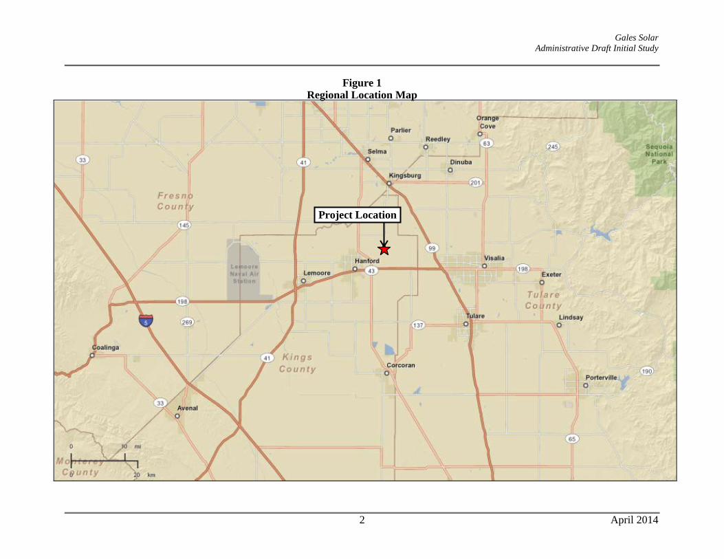
Gales Solar Administrative Draft Initial Study
Figure 1 Regional Location Map
Project Location
2 April 2014

Gales Solar Administrative Draft Initial Study
Figure 2 Project Location Map
Project Site
3 April 2014

Gales Solar Administrative Draft Initial Study
The soil survey performed during the preparation of the project-specific Geotechnical Report determined that the project site is in an area containing the Kimberlina Series soil.1 The soil survey describes the Kimberlina Series as very deep, well-drained soil on alluvial fans. Kimberlina fine sandy loam, saline-alkali (map unit 130) is mapped over the extent of the project site; and this soil series is considered by the California Department of Conservation to be Farmland of Statewide Importance.2 The project site is surrounded by the following uses: North: A farmed portion of the subject parcel (APN 014-090-033), which would remain in
agricultural production, beyond which are a dirt road, four single family residences, agricultural land, and a diary.
South: A dirt access road is located to the south, beyond which is an orchard and agricultural land. A single-family residence is located at the southern end of the orchard, approximately 1,100 feet from the southern end of the Gales Solar site boundary. A dairy is located on the south side of Fargo Avenue.
East: A dirt access road and an approximately 52-foot wide irrigation canal (Melga Canal) border the project site to the east. The canal has no hydrologic connectivity to the project site.
West: A single-family residence is located on the same parcel (APN 014-090-033), immediately west of the proposed solar facility area. Agricultural land, two dairies, agricultural residences, and the Settlers Ditch are located west of 7th Avenue.
Project Purpose and Need Electricity generation is California’s second largest source of greenhouse gas (GHG) emissions, after the transportation sector. In 2004, electricity generation accounted for approximately 25 percent of the State’s GHG emissions, while transportation produced more than 38 percent of California’s total emissions (source: California Energy Commission, 2009). Under California Executive Order S‐14‐08, all retail sellers of electricity are required to serve 33 percent of their load with renewable energy by 2020. In its first year of operation, the proposed project will generate approximately 6,770 MWhrs/year, equivalent to roughly the energy used by 720 homes, or removing 900 passenger cars, per year from the roadways.3 Project Components The Gales Solar Project (“the proposed project”) consists of the development of a 3 Megawatt AC (MW) ground‐mounted photovoltaic (PV) solar array, which will provide clean, renewable energy to the Hanford/Kings County area. The proposed solar project will utilize roughly 22
1 Holdrege & Kull. Geotechnical Engineering Report for Gales Photovoltaic Facility, 7th Avenue, Kings County, California. April 9, 2013. 2 California Department of Conservation, Farmland Mapping and Monitoring Program. Soil Candidate Listing for Prime Farmland and Farmland of Statewide Importance, Kings County. September 1986. 3 See http://www.epa.gov/cleanenergy/energy-resources/calculator.html for EPA Greenhouse Gas Calculator.
4 April 2014

Gales Solar Administrative Draft Initial Study
acres of the approximately 28‐acre parcel, located on 7th Avenue, between Flint Avenue and Fargo Avenue. Buildings are not included as a part of the project. The proposed project will electrically connect directly to Southern California Edison’s (SCE) existing 12kV distribution system, located adjacent to the southwestern corner of the property. Other than an approximately 100‐foot “gentie” electrical connection power line running from the southwestern edge of the project site to an adjacent power pole on the eastern side of 7th Avenue, new off-site transmission or distribution lines are not proposed. The 100-foot gentie power line will tie in via an underground electrical cable run to the existing utility power poles adjacent to the southwest corner of the site on 7th Avenue. If, during SCE’s review of the engineering documents, it becomes necessary to replace the power poles with newer poles (of the same height and construction), the power pole improvements would occur in existing disturbed areas; as a result, construction of said poles would not result in any environmental impacts. The electricity produced by the solar project will be sold to SCE through a long-term, 20-year, power purchase agreement (PPA) under SCE’s “CREST” Feed-in-Tariff (FIT) renewable energy program. The project is designed to have a useful life of 20 to 30 years, although the life span could be extended by upgrades and refurbishments. The project has both Interconnection Agreements and Power Purchase Agreements (PPAs) in place with SCE. Solar Facility Design The 28-acre project parcel is a portion of a much larger Farmland Security Zone (FSZ) contract (contract #00011), comprised of approximately 517 acres. Thus the project site constitutes just over approximately 5 percent of the total contracted land in this contract. The application for this FSZ contract was approved in 1998; and the effective date was January 1, 1999. The applicant has petitioned the State Department of Conservation (DOC) to cancel the existing FSZ contract for the project site. If the DOC cancels the existing FSZ contract, then the applicant does not intend to continue farming operations on-site. However, if the DOC does not cancel the site’s FSZ contract, the applicant would need to continue agricultural operations on-site in conjunction with the proposed solar generation use. As a result, both the fixed-tilt and single-axis tracking design options for the project include a “Continuous Agricultural Area” on-site. These project details are discussed in more detail below.
Fixed-Tilt The Site Plan (see Figure 5) for the fixed-tilt system includes the proposed 17.5-acre solar generation facility, as well as a proposed 4.46-acre “continuous agricultural area.”
The general layout can be summarized as follows:
1. The solar panels are mounted on a simple post, rail, and cross beam construction (panels do not move or “track” the sun).
2. The panels are tilted in a southwestern direction for fixed‐tilt systems. 3. The low end of the panels (which face southwesterly) will be approximately two
feet above the ground and the high end of the panels will be a maximum of ten feet off the ground.
5 April 2014

Gales Solar Administrative Draft Initial Study
4. Vertical steel posts are installed via a pneumatic ramming technique and are set in concrete footings (2 feet in diameter x 3.5 feet in height). Spacing between each row of panels (post to post) will be approximately 10-14 feet.
According to the Site Plan (see Figure 5) for the fixed-tilt option, the solar facility would be arranged into two “blocks”, and would include a total of approximately 41,400 “thin film” PV panels. These PV panels are dark in appearance and contain an environmentally safe non-reflective coating. Two concrete inverter pads (approx. 26 feet x 37 feet each), supporting four inverters, would be located in the central portion of the project. The electrical power conditioning equipment (switchgear) associated with the project would also be installed on two concrete pads (approx. 22 feet x 27 feet each) in the southwestern corner of the project site. Interior electrical conduit will be placed in subsurface trenches. Single-Axis Tracking Similar to the fixed-tilt system, the Site Plan (see Figure 6) for the single-axis tracking system includes the proposed 17.5-acre solar generation facility, as well as a proposed 4.46-acre “continuous agricultural area.”
The general layout and assembly can be summarized as follows:
1. The solar panel rows would be oriented in a north-south direction. 2. Once the posts are installed, the horizontal cross-members of the tracking system
and associated motors would be placed and secured. 3. A galvanized metal racking system, which would hold the PV modules in the
proper position for maximum capture of solar insulation, would then be field-assembled and attached to the horizontal cross members. The racking system would include a mechanism that would allow the array to track the path of the sun (from east to west) throughout the day. In the morning the panels would face the east; throughout the day, the panels would slowly move to the upright position at noon and then move on to face the west at sundown. The panels would reset to the east in the evening or early morning to receive sunlight at sunrise.
4. The single-axis tracker system would include up to 12 electric motors (4 motors per 1 MW) to rotate the tracking system throughout the day. These motors are anticipated to be 1.5 to 3 horsepower.
5. Vertical steel posts are installed via a pneumatic ramming technique and are set in concrete footings (2 feet in diameter x 3.5 feet in height). Spacing between each row of panels (post to post) will be approximately 10-14 feet.
According to the Site Plan for the tracking option, the solar facility will be arranged into “blocks” separated by internal gravel access driveways. The single-axis system would consist of 11,420 “crystalline silica” PV panels, which are dark in appearance and contain an environmentally safe non-reflective coating.
6 April 2014

Gales Solar Administrative Draft Initial Study
Similar to the fixed-tilt system, two concrete inverter pads (approx. 26 ft x 37 ft each), supporting four inverters, would be located in the central portion of the project. The electrical power conditioning equipment (switchgear) associated with the project would also be installed on two concrete pads (approx. 22 ft x 27 ft each) in the southwestern corner of the project site. Interior electrical conduit will be placed in subsurface trenches.
High-Value Crop Continuous Agricultural Area and Sheep Grazing Area If cancellation of the FSZ contract is not approved, agricultural operations would continue on-site in conjunction with the proposed solar use. In order for this option to be feasible, the continued agricultural operations will need to produce a similar overall economic and productivity return as has historically existed on the subject property, in accordance with the Williamson Act principles of compatibility and performance standards established in Government Code Section 51238.1, which are discussed in detail in the Agriculture and Forest Resources section of this IS/MND. As shown on both the fixed-tilt and tracking Site Plans, a 4.5-acre “Continuous Agricultural Area” for high-value crops has been incorporated into the site design. This represents approximately 20% of the total 22-acre lease area. In addition, sheep grazing/husbandry activities are proposed on approximately 16.5 acres of the remaining acreage (or a total of almost 95% of the remaining site footprint). Growing high value seasonal crops, such as strawberries, sweet corn, and/or melons on only 1-acre of the solar lease area can produce an equivalent or greater economic output than the entire parcel has historically yielded. Sheep grazing/husbandry is proposed on the remainder of the property (in between and under the rows), and would substantially maintain the property in an agricultural use. An off-site agricultural well and the adjacent water canal have historically been used for on-site agricultural irrigation purposes. For this option, water for the continuous agricultural area would be provided by a new on-site agricultural well, and/or utilization of an existing off-site well, and/or the adjacent water canal. If a new agricultural well is installed on-site, the well would be sited and constructed per Kings County standards.
7 April 2014

Gales Solar Administrative Draft Initial Study
Figure 3 Single-Axis Tracking System – Representative Photos
8 April 2014

Gales Solar Administrative Draft Initial Study
Figure 4 Fixed-Tilt System – Representative Photos
9 April 2014

Gales Solar Administrative Draft Initial Study
Figure 5 Gales Solar Fixed-Tilt Site Plan
10 April 2014

Gales Solar Administrative Draft Initial Study
Figure 6 Gales Solar Single Axis Tracking Site Plan
11 April 2014

Gales Solar Administrative Draft Initial Study
Site Drainage After the project is fully installed, more than 97 percent of the 28-acre site will remain permeable; impermeable structures, including the foundations supporting the inverter pads, will cover, in total, less than half an acre of the project site. As a result, the project would minimally increase stormwater runoff at the site. During storm events, rainwater would flow off of the solar panels to the ground surface. The edge of the panels would be approximately 18‐24 inches above the ground. Water will fall from the PV panels and infiltrate or gradually migrate into the existing on-site drainage patterns. Currently, during storm events, stormwater sheet flows on the site towards the northeast, along existing drainage patterns. If, over time, minor erosion is noted at the base of the panels, small gravel pads could be added to help dissipate the energy of the falling water. If minor erosion were noted near the foundations, minor grading could restore support for the individual foundations, and keep surface flows from undermining the foundations in future storm events. Hazards & Hazardous Materials Other than typical hazardous materials incidentally used during construction and operations (e.g., small quantities of lubricating oils for hand held tools, gasoline and diesel in on-site vehicles and construction machinery, and (plant‐based) transformer oil), hazardous materials will not be used or stored on-site. The two on-site transformers will be constructed of stainless steel, and will each contain up to approximately 400 gallons of Envirotemp FR3 Fluid, which is a di‐electric non-toxic vegetable (soybean) oil manufactured by Cooper Power Systems. The oil is used as an insulation and cooling medium. The project would not maintain any portable oil storage tanks on‐site. The project may, at times, contain the following:
• 5-gallon portable containers of gasoline/diesel for use with landscaping equipment, small generators and on‐site vehicles.
• 1-gallon portable containers of oil for use with landscaping equipment and small generators.
Absorbent spill response materials would be stored on‐site in a self-contained spill kit, on the switchgear or inverter pads, for use in the unlikely event of small quantity spills (less than 50 gallons). Spill response materials are used to respond to chemical material spills at the facility, and would therefore be used to contain a spill of the portable oil containers or small vessels. Driveway/Access Access to the project site would be provided via one new access driveway from 7th Avenue. The new access driveway will be 30 feet wide, per County standards, with a 28‐foot wide gate,
12 April 2014

Gales Solar Administrative Draft Initial Study
accommodating a 45‐foot long turning radii in both directions. A 15-foot wide all weather non-combustible surface internal driveway would be constructed around the perimeter of the entire site, within the boundaries of the security fence. Security As customary under utility regulations and to prevent theft, the project will be surrounded by a six‐foot tall chain‐link fence, topped with one-foot of barbed‐wire. As described in Mitigation Measure IV-3 of this IS/MND, the project security fence will have a continuous 5-inch opening between the fence mesh and the ground, or the fence will be raised 5 inches above the ground, to allow passage of wildlife. The bottom of the fence fabric will be knuckled (wrapped back to form a smooth edge) to protect wildlife that passes under the fence. Additionally, the project will be continuously monitored remotely – any tampering or removal of equipment will trigger alarms at a monitoring center. Operations and maintenance personnel will then be dispatched to the site on an as-needed basis. Signs will be installed to achieve the appropriate safety and security as expected in a solar power facility. Proposed signage includes “high voltage danger”, “site under surveillance”, “caution electric shock”, etc. Any signs as required by the National Electrical Code will be installed. Lighting and landscaping are not proposed. Decommissioning At the end of the project operation term, the applicant may determine that the project should be decommissioned and deconstructed. Because the PV arrays supporting equipment sits on the surface of the land, when they are removed after the project’s lifetime, the land will be largely unaltered from its natural state. Belectric will work with Kings County to put an agreement in place that will ensure the decommissioning of the project after its productive lifetime, including a soil reclamation plan and financial assurance. Both the soil reclamation and financial assurance will need to be submitted to and approved by the County prior to issuance of the building permits for this project. Other Permits and Approvals that may be required It is anticipated that the following “typical” permits may be needed for this project (in typical order of issuance):
1. Conditional Use Permit (Planning/Zoning) 2. NPDES Permit (Stormwater/Erosion Control) 3. Grading Permit 4. Encroachment/Entrance Permit (for work in public street) 5. Building Permit (Structural/Electrical) 6. Electrical or Utility Permit (if needed separately from the general building permit) 7. Farmland Security Zone Contract Cancellation. The Gales Solar site is Farmland Security
Zone property under the California Land Conservation Act of 1965 (commonly referred to as the Williamson Act). The Applicant intends to implement one of two options with respect to the existing FSZ contract. The first option involves cancelling the FSZ contract
13 April 2014

Gales Solar Administrative Draft Initial Study
for the 22-acre solar site. This option will require approval from the California Department of Conservation and the Kings County Board of Supervisors. If cancellation of the FSZ contract is not approved, the applicant would pursue agricultural operations on the site, which satisfy the principles of compatibility under California Government Code Section 51238.1. In the event that the applicant is unable to obtain approval for the cancellation of the FSZ contract, then the applicant shall provide an Agriculture Management Plan describing the commercial agricultural operations consistent with the compatibility findings of California Government Code Section 51238.1 prior to issuance of a building permit. The Agriculture Management Plan shall be in effect for the operational life of the project and would meet the principles of compatibility outlined in California Government Code Section 51238.1.
Project Construction Construction of either proposed project option is estimated to require approximately 35 workers at its peak, including Belectric employees and skilled local professionals and labor resources. During construction, single shifts, 5‐6 days per week during construction are expected. Construction is estimated to start in 2014 and would take approximately three months to complete. During construction, the following vehicles will be used on-site:
• 2‐3 Ramming Machines • 1‐2 Excavators • 1‐2 Backhoes • 2‐4 Concrete Buggies • 4 Passenger Trucks
The development of the project is expected to require limited site grading, in the amount of approximately 3,500 square feet, with limited impact to existing off-site drainage patterns and overall topography of the site. The limited grading would be associated with minor cuts at the locations of inverters and other equipment to provide level foundations on properly prepared subgrade. Internal access driveways will be provided by placing and compacting a pervious, non-combustible material such as gravel or decomposed granite. The installation of the solar panels requires trenching throughout the project site for the installation of the buried electrical wire (cable) systems. Electrical wiring will be installed using “direct bury” technique, and will be located within trenches, with a depth range of approximately 18‐48 inches to be backfilled with excavated material from the site. In total, approximately 24,000 linear feet of utility trenching is anticipated on-site. A Stormwater Pollution Prevention Plan (SWPPP) and an Erosion and Sediment Control Plan will be prepared and implemented to avoid and minimize impacts on water quality during construction and operations. Best management practices (BMPs) for erosion control would be implemented to avoid and minimize impacts on the environment during construction, operations and maintenance, as discussed below.
14 April 2014

Gales Solar Administrative Draft Initial Study
Grading and Preservation of Existing Vegetation Existing vegetation shall be preserved to the maximum extent practicable. Clearing and grubbing shall only be performed in areas where new foundations, utilities, or internal access drives are planned. Soil Compaction All soil compaction and subgrade preparation specifications will be per the site‐specific recommendations of a California‐licensed Geotechnical Engineer, and will be based on his field exploration prior to construction. Typically, trench backfill and subgrade compaction consists of either hand‐held vibratory, rolled-drum equipment, or tracked equipment. Compaction would be 90 percent of maximum density as calculated by ASTM D1557 Modified Proctor. Hydroseeding Disturbed areas will be seeded upon completion of construction in order to protect exposed soils from erosion by wind and water. Upon completion of an earth disturbance activity, disturbed areas shall be covered with a minimum uniform 70 percent perennial vegetative cover, with a density capable of resisting accelerated erosion and sedimentation. The vegetative cover will also be chosen to be appropriate for the proposed sheep grazing activities in the event the continued farming concept is chosen. Straw Mulch Straw mulch will be used to temporarily stabilize disturbed areas until soil can be prepared for revegetation. Straw mulch will be anchored immediately after application to prevent being windblown. Straw or hay will be “crimped” into the soils by running tracked machinery across the surface. Non-Vegetative Stabilization A non‐combustible surface will surround the project site to function as a fire break as well as provide a stabilized surface for post‐construction access. Non‐vegetative stabilization methods, such as gravel mulch, will be used to provide a stabilized 12‐foot wide access. Stabilized Construction Entrance/Exit A stabilized construction entrance/exit will be maintained at each construction site entrance/exit to reduce tracking of sediment as a result of construction traffic. The entrance/exit will be constructed per the detail included with the Erosion and Sediment Control Drawings (ESCDs). Stabilized Construction Roadway The construction access route into the site will also be maintained to prevent erosion and to control tracking of mud and soil material onto adjacent roads. The ESCDs will specify the construction access locations. A regular maintenance program will be conducted to replace sediment‐clogged stabilization material with new stabilization material as required.
15 April 2014
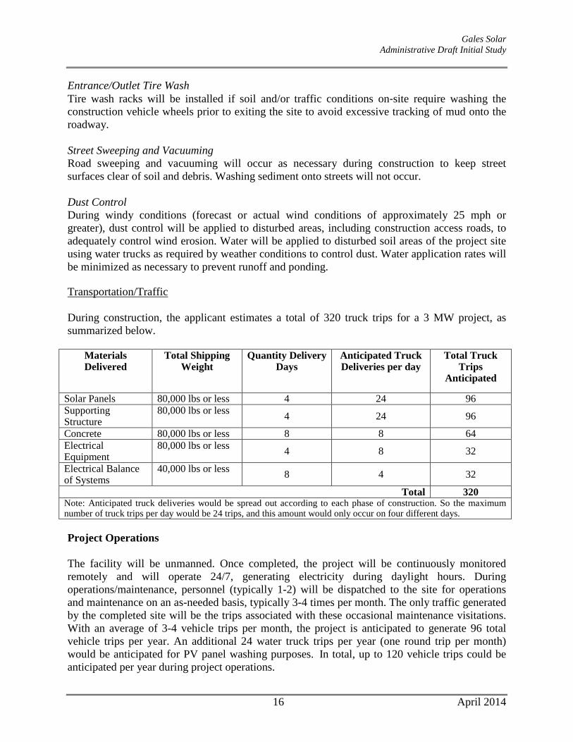
Gales Solar Administrative Draft Initial Study
Entrance/Outlet Tire Wash Tire wash racks will be installed if soil and/or traffic conditions on‐site require washing the construction vehicle wheels prior to exiting the site to avoid excessive tracking of mud onto the roadway. Street Sweeping and Vacuuming Road sweeping and vacuuming will occur as necessary during construction to keep street surfaces clear of soil and debris. Washing sediment onto streets will not occur. Dust Control During windy conditions (forecast or actual wind conditions of approximately 25 mph or greater), dust control will be applied to disturbed areas, including construction access roads, to adequately control wind erosion. Water will be applied to disturbed soil areas of the project site using water trucks as required by weather conditions to control dust. Water application rates will be minimized as necessary to prevent runoff and ponding. Transportation/Traffic During construction, the applicant estimates a total of 320 truck trips for a 3 MW project, as summarized below.
Materials Delivered
Total Shipping Weight
Quantity Delivery Days
Anticipated Truck Deliveries per day
Total Truck Trips
Anticipated
Solar Panels 80,000 lbs or less 4 24 96 Supporting Structure
80,000 lbs or less 4 24 96
Concrete 80,000 lbs or less 8 8 64 Electrical Equipment
80,000 lbs or less 4 8 32
Electrical Balance of Systems
40,000 lbs or less 8 4 32
Total 320 Note: Anticipated truck deliveries would be spread out according to each phase of construction. So the maximum number of truck trips per day would be 24 trips, and this amount would only occur on four different days. Project Operations The facility will be unmanned. Once completed, the project will be continuously monitored remotely and will operate 24/7, generating electricity during daylight hours. During operations/maintenance, personnel (typically 1-2) will be dispatched to the site for operations and maintenance on an as-needed basis, typically 3-4 times per month. The only traffic generated by the completed site will be the trips associated with these occasional maintenance visitations. With an average of 3-4 vehicle trips per month, the project is anticipated to generate 96 total vehicle trips per year. An additional 24 water truck trips per year (one round trip per month) would be anticipated for PV panel washing purposes. In total, up to 120 vehicle trips could be anticipated per year during project operations.
16 April 2014

Gales Solar Administrative Draft Initial Study
Weed Abatement The applicant will submit a Weed Abatement Plan for County review and approval in accordance with the requirements of Kings County Code Section 1908.H. Weed and vegetation control would be conducted throughout the project site for the duration of the life of the project. Weed control would consist of chemical, biological (including sheep grazing), mechanical, or manual methods, or a combination of these methods. Frequency and method of weed and vegetation control would be determined by the project operator based on fuel load, weed type and location, environmental conditions, and availability of equipment or resource. Pest Management The applicant will submit a Pest Management Plan (PMP) for County review and approval in accordance with Section 1908.H of the Kings County Zoning Ordinance. The PMP will outline objectives and methods for preventing and controlling potential pest infestations at the Gales Solar facility, particularly rodent infestations. The PMP will focus on preventative controls (e.g., weed cover removal) rather than removal options. Solid Waste Management Prior to project construction, the applicant will prepare a materials disposal and solid waste management plan for review and approval by the County, which would address waste from construction and operational activities. More specifically, the Plan will address such items as PV module recycling, during the decommission phase of the project; PV module disposal, in the event that modules are damaged during shipping or decommissioning of the project; waste reduction goals; and disposal locations.
ENVIRONMENTAL FACTORS POTENTIALLY AFFECTED The environmental factors checked below would be potentially affected by this project, involving at least one impact that is a “Potentially Significant Impact” as indicated by the checklist on the following pages. Aesthetics Agriculture and Forestry
Resources Air Quality
Biological Resources Cultural Resources Geology & Soils Greenhouse Gas Emissions Hazards and Hazardous
Materials Hydrology & Water Quality
Land Use and Planning Mineral Resources Noise Population & Housing Public Services Recreation Transportation & Circulation Utilities & Service
Systems Mandatory Findings of
Significance
17 April 2014

Gales Solar Administrative Draft Initial Study
I. AESTHETICS. Would the project:
Potentially Significant
Impact
Less Than Significant
with Mitigation
Incorporated
Less-Than-Significant
Impact No
Impact
a. Have a substantial adverse effect on a scenic vista?
b. Substantially damage scenic resources, including, but not limited to, trees, rock outcroppings, and historic buildings within a State scenic highway?
c. Substantially degrade the existing visual character or quality of the site and its surroundings?
d. Create a new source of substantial light or glare which would adversely affect day or nighttime views in the area?
I a) Less Than Significant Impact. The Gales solar site would not be located within the
viewshed of any scenic vista. Two designated scenic areas are located within Kings County: a portion of the Kings River near the northern border of the County, and the Coast Range area in southwestern Kings County.4 As illustrated in Figure 4.1-1 of the General Plan EIR, “Scenic Lands and Potential Scenic Highways in Kings County,” the project site is not located near any designated scenic lands. Other important scenic areas in the County are Cross Creek in northern Kings County and the mountain terrain of the County’s southwest edges.5 The project site is not located near these other important scenic areas identified in the Open Space Element. The project would therefore have a less-than-significant impact on scenic vistas.
I b) Less Than Significant Impact. The proposed project will not substantially damage
scenic resources, including, but not limited to, trees, rock outcroppings, and historic buildings within a state scenic highway, because the site is not adjacent to a state scenic highway, and trees, rock outcroppings, or historic buildings do not exist on the project site. Designated scenic highways are not located within Kings County, although a portion of State Route (SR) 41, from its intersection with SR 33 and proceeding to the San Luis Obispo County line, has been proposed as an eligible State scenic highway.6 The Gales Solar site is located approximately 41 miles northeast of the intersection of SR 41 and SR 33. This would be considered a less-than-significant impact.
I c) Less Than Significant Impact. The proposed project will utilize approximately 22 acres
of the 28-acre parcel, located on 7th Avenue, between Flint Avenue and Fargo Avenue. The project site is in active agricultural production. At the time of the writing of this
4 Kings County. County of Kings 2035 General Plan Update EIR. June 2009, see Figure 4.1-1. 5 Kings County. 2035 Kings County General Plan. Adopted January 26, 2010, see Open Space Element, p. OS-5. 6 http://www.dot.ca.gov/hq/LandArch/scenic/cahisys.htm; accessed January 28, 2014.
19 April 2014

Gales Solar Administrative Draft Initial Study
Initial Study, the site was planted with grain crops. The project site is surrounded by agricultural lands and rural residences.
The project would introduce a solar generation facility on the site. The facility would generally consist of rows of solar arrays and associated inverter and switchgear equipment, an internal access road, and a 7-foot high security perimeter fence. Buildings would not be constructed as part of the project. According to the Site Plans (see Figures 5 and 6 for the fixed-tilt and tracking options, respectively), the solar facility will be arranged into “blocks” separated by internal access driveways. The proposed project includes a total of approximately 41,400 “thin film” PV panels (for fixed-tilt system) or 11,420 “crystalline silica” PV panels (tracking system). Both types of modules are dark in appearance and contain a non-reflective coating, which is environmentally safe.
For both project options, spacing between each row of panels (post to post) will be approximately 10-14 feet. A galvanized metal racking system would hold the PV modules in the proper position for maximum capture of solar insulation. For the tracking system, the racking system would include a mechanism that would allow the array to track the path of the sun (from east to west) throughout the day. In the morning the panels would face the east; throughout the day, the panels would slowly move to the upright position at noon and then move on to face the west at sundown. The panels would reset to the east in the evening or early morning to receive sunlight at sunrise. Under the fixed-tilt system, the panels would not move and would be oriented to face in a southwesterly direction.
The number of viewers of the Gales solar site would be relatively low and limited primarily to motorists along 7th Avenue and Flint Avenue, , as well as several residences north of the project site, and the single residence located immediately west of the site. Motorists are considered to have a lower expectation of a view than local residents because motorist views are temporary and generally less frequent than views from homes; they occur while the viewer is focused on the activity of driving while the vehicle is moving; and they are limited to the periphery of the driver’s vision. Furthermore, none of the roads from which the project site is visible are designated as scenic routes. When considering the change in visual character of the site and how this affects the views of the site currently afforded to adjacent residences, one must first determine the scenic quality of the existing site. The Federal Highway Administration (FHWA) Visual Impact Assessment for Highway Projects7 is commonly used to assess the potential visual impacts of development projects. Dimensions of landscape quality taken into account for the FHWA landscape evaluation and visual impact assessment include vividness, unity, and intactness. Vividness is defined as the memory of the visual impression received from contrasting landscape elements as they combine to form a striking and distinctive visual pattern. Intactness is defined as the integrity of the visual order in the natural and human-built landscape, and the extent to which the landscape is free from visual encroachment. Unity is defined as the degree to which the visual resources of the
7 Federal Highway Administration. Visual Impact Assessment for Highway Projects. 1988.
20 April 2014

Gales Solar Administrative Draft Initial Study
landscape join together to form a coherent, harmonious visual pattern, and the term refers to the compositional harmony or degree of intercompatibility between landscape elements. The visual quality of the existing Gales solar site is low, as determined using the FHWA methodology. Due to the lack of remarkable features on site, the vividness of the project site is low – i.e., the visual pattern of the site is not so distinctive as to be impressed upon one’s mind. The intactness of the project site is also low, due to adjacent single family development, and that which is associated with the community of nearby Hanford. Because the project site has been subjected to substantial ground disturbance from agricultural use, the unity of the site is also low. Construction and operation of the project would require the conversion of land characterized by rural use to land occupied by rows of solar panels and associated equipment. These visual intrusions would not result in a significant diminishment of visual quality because the vividness, intactness, and unity of the site are already low due to adjacent development and previous land disturbance associated with agricultural production.
The maximum height of the PV modules for the single-axis tracking system is anticipated to be 8 feet, though PV module heights would often be less as the modules track the sun throughout the day. Should the applicant pursue a fixed-tilt system, the maximum height of the PV modules would be 10 feet. At a maximum height of approximately 10 feet, depending upon the selected system, the proposed PV modules would be relatively low in profile. Furthermore, prominent scenic landscapes are not currently visible beyond the project site. Impacts on both motorists and residents in the area would be less than significant because the proposed project would be located in an area with existing low visual quality, and scenic features are not located beyond the project site, views of which could be blocked by the proposed PV modules.
I d) Less Than Significant Impact. The proposed solar panels will have an anti-reflective
coating, which absorbs light and eliminates reflection. In addition, the project does not include installation of any lighting fixtures. Because the project would include anti-reflective coating on the solar panels, and lighting will not be installed, the proposed facility would not have a significant impact on daytime or nighttime views in the area.
21 April 2014

Gales Solar Administrative Draft Initial Study
II. AGRICULTURE AND FOREST RESOURCES. Would the project:
Potentially Significant
Impact
Less Than Significant
with Mitigation
Incorporated
Less-Than-Significant
Impact No
Impact
a. Convert Prime Farmland, Unique Farmland, or Farmland of Statewide Importance (Farmland), as shown on the maps prepared pursuant to the Farmland Mapping Program of the California Resources Agency, to non-agricultural use?
b. Conflict with existing zoning for agricultural use, or a Williamson Act contract?
c. Conflict with existing zoning for, or cause rezoning of, forest land (as defined in Public Resources Code section 12220(g)), timberland (as defined by Public Resources Code section 4526), or timberland zoned Timberland Production (as defined by Government Code section 51104(g))?
d. Result in the loss of forest land or conversion of forest land to non-forest use?
e. Involve other changes in the existing environment which, due to their location or nature, could individually or cumulatively result in loss of Farmland to non-agricultural use?
The project would be located on 22.0 acres of a 28.0-acre parcel that contains an existing agricultural residence and 27.0 acres of disturbed agricultural land in unincorporated Kings County. The project facilities would be located 2.11 miles northeast of the City of Hanford. Agriculture is the predominant land use in Kings County, which ranked ninth in the State in 2010 for agricultural production value (Kings County Department of Agricultural Measurement Standards 2011). Section I.B on Page I-3 of the Introduction to the 2035 Kings County General Plan states that of the County’s 1,391 square miles, approximately 90.2 percent of all land is devoted to agricultural uses. The agricultural industry remains an important component of the Kings County economy, and the preservation of agricultural lands is regarded as a high priority for local land use planning agencies in the region. Section II.B on Page RC-16 of the Resource Conservation Element of the 2035 Kings County General Plan states that of the approximate 810,887 agricultural acres within the County, approximately 84 percent (682,864 acres in 2008) were under contract. In 2008, Williamson Act contracts accounted for 53 percent (361,864 acres) and Farmland Security Zone contacts accounted for 47 percent (320,959 acres). The Land Use Map of Hanford “Urban Fringe”, Figure LU-16 of 2035 Kings County General Plan, designates the Project site as General Agriculture (AG-20). The property is located in the General Agricultural (AG-20) zone district. The project site is designated as Farmland of Statewide Importance on the 2010 Important Farmland Map prepared by the California Department of Conservation, Division of Land Resource Protection, implemented with the Farmland Mapping and Monitoring Program (FMMP). The project site is located on land currently under a Farmland Security Zone Contract.
22 April 2014

Gales Solar Administrative Draft Initial Study
The Resource Conservation Element of the 2035 Kings County General Plan identifies natural resources throughout the County and established guiding policies for the conservation, development, and utilization of these elements that promotes sustained economic health through long-term resource protection. The Kings County Community Development Agency (CDA) developed the “Priority Agricultural Land Model” by utilizing relevant information resources to evaluate farmland resources throughout the County. The State of California, Department of Water Resources 2003 Land Use Survey Data; Kings County Agricultural Commissioner-Sealer Department; Department of Conservation’s 2006 Important Farmland Map; and the National Resources Conservation Service (NRCS) Soil Classification Map were all resources used to rate farmland resources throughout the County. Figure RC-13 “Priority Agricultural Land,” in the Resource Conservation Element of the 2035 Kings County General Plan designates the project site as Medium Priority Land. As shown in Figure 7, the Gales Solar site is designated Medium Priority Land. According to Land Use Goal B7 of the Land Use Element of the 2035 Kings County General Plan, Agricultural Open Space areas are compatible with “Community benefiting non-agricultural uses”. Specifically, Land Use Policy B7.1.3 states, “Power generation facilities for commercial markets shall be allowed and regulated through the CUP approval process, and include thermal, wind, and solar PV electrical generating facilities that produce power”. Section II.G, on Page RC-33 of the Resource Conservation Element of the 2035 Kings County General Plan, states “The construction of commercial solar farms in agriculturally zoned land is a conditional use in Kings County, and should be directed to lower priority farmland.” In addition, Kings County Zoning Ordinance 269.69 Section 402.D.21 states that “wind and solar PV electrical generating facilities that commercially produce power for sale, which comply with all local, regional, State, and Federal regulations” may be permitted in accordance with the provisions of Article 19 on land zoned AG-20, with Planning Commission approval. Section 1908.H of the Kings County Zoning Ordinance sets forth certain findings the Planning Commission needs to make to grant a CUP for a solar PV electrical facility. These findings are addressed in the Land Use and Planning Section (X) of this IS/MND. In 1996, Kings County adopted a Right to Farm Ordinance “to protect the rights of commercial farming operations” while promoting a “good neighbor” policy between agricultural and other uses in the County. The intent of the ordinance is to protect agricultural uses from conflicting uses that may encroach on agricultural land and to advise non-agricultural developers in the County that certain inconveniences and discomforts associated with agricultural activities (such as noises and odors) could affect the use of their own property.
23 April 2014

Gales Solar Administrative Draft Initial Study
Figure 7 Priority Agricultural Land – Gales Solar Site
24 April 2014

Gales Solar Administrative Draft Initial Study
II a,e) Less Than Significant with Mitigation Incorporated. The soil survey performed
during the preparation of the project-specific Geotechnical Report determined that the project site is in an area containing the Kimberlina Series soil.8 The soil survey describes the Kimberlina Series as very deep, well-drained soil on alluvial fans. Kimberlina fine sandy loam, saline-alkali (map unit 130) is mapped over the extent of the project site; and this soil series is considered by the California Department of Conservation to be Farmland of Statewide Importance.9
The land upon which the Gales Solar project would be located is subject to California Farmland Security Zone Contract No. 00011. The project site constitutes only 5 percent of the total 517-acre area of FSZ Contract No. 00011. In 2010 Kings County had 320,959 acres of Farmland Security Zone (FSZ) contracted land and the project site (22 acres) constitutes less than one-half of one percent of FSZ contracted land in Kings County (Section II.B on Page RC-16 of the Resource Conservation Element of the 2035 Kings County General Plan). California Government Code Section 51296 enables local governments to enter into Farmland Security Zone (FSZ) contracts, which are contracts with an initial term of no less than 20 years and entered into between private landowners and the County for the purpose of restricting specific parcels of land to agricultural or compatible uses. In return, restricted parcels are assessed for property tax purposes at a rate consistent with their actual, farming, and open space uses, as opposed to potential market value.
The applicant would implement one of two options to reduce impacts related to the Williamson Act. 1. Option 1: The first option proposes cancellation of the existing FSZ contract. Under
this option agricultural operations would be discontinued on the site during the lifetime of the project. The temporary use of the land for solar development would represent a very small portion of the overall, currently designated farmland in Kings County, as well as of the total amount of land within FSZ Contract No. 00011 (approximately 5 percent). Temporarily (i.e. for the lifetime of the project) removing the project site from agricultural production would have the potentially adverse impact of converting “Farmland of Statewide Importance” to non-agricultural use. Implementation of Mitigation Measures II-1, II-2 and II-3 would reduce this impact to a less-than-significant level by requiring agricultural operations off-site, (i.e. on mitigation land), soil reclamation and associated financial assurances.
2. Option 2: If FSZ cancellation is unsuccessful, this project option would consist of
solar generation along with continued on-site agricultural operations. Under this
8 Holdrege & Kull. Geotechnical Engineering Report for Gales Photovoltaic Facility, 7th Avenue, Kings County, California. April 9, 2013. 9 California Department of Conservation, Farmland Mapping and Monitoring Program. Soil Candidate Listing for Prime Farmland and Farmland of Statewide Importance, Kings County. September 1986.
25 April 2014

Gales Solar Administrative Draft Initial Study
option, the applicant would prepare and implement, during the operational life of the project, an Agriculture Management Plan (AMP) that completely satisfies the Williamson Act principles of compatibility and the performance standards established in Government Code Section 51238.1. Under this option, a “continuous agricultural area” would be cultivated with strawberries, sweet corn, and/or melons, to produce an equivalent or greater economic output than the entire parcel has historically yielded, with the remainder of the project lease parcel to be utilized for sheep grazing/husbandry, as discussed in Section IIb below, in order to produce an equivalent or greater productivity output compared to the site’s historical output.
If continued agricultural operations can yield equivalent economic and productivity return as compared to existing (pre-project) conditions,10 the project could still have potential adverse impacts by conversion of “Farmland of Statewide Importance” to a non-agricultural use, but only if long-term production on the site is significantly compromised by not reclaiming the soil and/or a lack of financial assurances. Implementation of Mitigation Measures II-1 and II-2 would reduce this impact to a less-than-significant level by requiring soil reclamation after the life of the project via financial assurances.
Mitigation Measures Implementation of the following mitigation measures would reduce the above-identified impacts to agricultural resources to a less-than-significant level. Required for FSZ Options 1 and 2 MM II-1: Soil Reclamation Plan. Prior to the issuance of a building permit, the
applicant shall submit a Soil Reclamation Plan for review and approval by Community Development Agency staff. The plan shall contain an analysis of pre-project baseline soil conditions, and shall contain specific measures to restore the soil to its pre-project condition, including removal of all fixtures, equipment, non-agricultural driveways, and restoration of compacted soil. Additionally, the Soil Reclamation Plan shall discuss the retention of any surface water rights. Reclamation shall commence within two months of the expiration of the use permit, or abandonment of the solar use, and completed within 18 months from the date the facility ceases to operate.
MM II-2: Financial Assurance. Prior to the issuance of a building permit, the
applicant shall post a performance bond or similar instrument to ensure completion of the activities under the Soil Reclamation Plan. Financial assurances for the Reclamation Plan will be reviewed every 5 years by the Kings County Community Development Agency to determine if finances are sufficient to perform reclamation of the project. The assurance must
10 This would be determined by the County-approved AMP in accordance with the performance standards outlined in Government Code Section 51238.1.
26 April 2014

Gales Solar Administrative Draft Initial Study
be adjusted if, during the five-year review, finances are determined to be insufficient to perform reclamation of the project.
Required for FSZ Option 1 Only – FSZ Cancellation MM II-3: Off-site Agricultural Mitigation. If the applicant is successful in cancelling
the Farmland Security Zone contract, but does not continue an intensive agricultural operation on the project site at an economic intensity equivalent to the existing agriculture use of the project site for the entire life of the project, the applicant shall provide written evidence of funding for and/or purchase of agricultural mitigation land (which shall be managed and maintained by an appropriate entity) for the life of the project to mitigate the loss of Farmland of Statewide Importance at the appropriate ratio (1:1), as determined by the Kings County Community Development Agency. Every acre of agricultural land removed from production shall be mitigated by the applicant. The agricultural land preserved shall be of equal or greater quality as defined by the California Department of Conservation Farmland Mapping and Monitoring Program (i.e., if Farmland of Statewide Importance is converted to solar use then the agricultural land preserved must not be in a classification indicating a lower quality than Farmland of Statewide Importance).
II b) This section will address existing agricultural zoning and Williamson Act contracts.
Existing Agricultural Zoning The project site is currently zoned AG-20. Solar generation facilities producing power
for sale are consistent with the AG-20 zone district through the conditional use permit process. Specifically, Kings County Zoning Ordinance 269.69, Section 402.D.21, states that “wind and solar photovoltaic electrical generating facilities that commercially produce power for sale, which comply with all local, regional, State, and Federal regulations” may be permitted in accordance with the provisions of Article 19 on land zoned AG-20, with Planning Commission approval (see Section X, Land Use and Planning, of this IS/MND for a detailed discussion regarding the project’s compatibility with the CUP findings set forth in Article 1908.H). With approval of a conditional use permit, this project would be consistent with the site’s existing agricultural zoning designation.
Williamson Act Contract The project site is under an active Farmland Security Zone (FSZ) contract. For this project, the applicant will either: 1) file a FSZ cancellation application package with, and obtain approvals from, the County and Department of Conservation on the 22-acre project site, initiating a separate review process from the County and the Director of the Department of Conservation; or – if cancellation of the FSZ contract is not approved – 2) maintain an on-site agricultural operation consistent with the principles of
27 April 2014
Gales Solar Administrative Draft Initial Study
compatibility of California Government Code Section 51238.1. Option 1 would require approval from the California Department of Conservation and the Kings County Board of Supervisors.
Additional Discussion for Project Option 2 – Continue Agricultural Operations On-site On March 27, 2012, the Kings County Board of Supervisors adopted Resolution No. 12-016, which determined that commercial solar generation facilities are not considered compatible by default under the provisions of Government Code Section 51238(a)(1), and that each project must demonstrate compatibility with the Williamson Act – pursuant to Government Code section 51238.1(a) – on its own merits.11 To be compatible, the project must be consistent with the following three principles:
1. The use will not significantly compromise the long-term productive agricultural capability of the subject contracted parcel or parcels or on other contracted lands in agricultural preserves.
2. The use will not significantly displace or impair current or reasonably foreseeable agricultural operations on the subject contracted parcel or parcels or on other contracted lands in agricultural preserves. Uses that significantly displace agricultural operations on the subject contracted parcel or parcels may be deemed compatible if they relate directly to the production of commercial agricultural products on the subject contracted parcel or parcels or neighboring lands, including activities such as harvesting, processing, or shipping.
3. The use will not result in the significant removal of adjacent contracted land from agricultural or open-space use.
The following discussion addresses how the proposed solar site could satisfy the principles of compatibility of Government Code Section 51238.1:
Government Code Section 51238.1. (a) Uses approved on contracted lands shall be consistent with all of the following principles of compatibility: (1) The use will not significantly compromise the long-term, productive agricultural
capability of the subject contracted parcel or parcels or on other contracted lands in agricultural preserves.
The applicant’s proposed alternative to cancellation of the Farmland Security Zone contract on the property contemplates, in addition to sheep grazing/husbandry within the solar arrays, the continued farming operations on a portion of the 22-acre solar lease area with high value crops to produce an equivalent, overall economic and productivity return as has historically existed on the subject property. A ten-year history of the average agricultural economic output for the project site is shown in Table 1 below.
11 Kings County. Staff Report for Public Hearing – Determination on Commercial Solar Compatibility with the Williamson Act. March 27, 2012.
28 April 2014

Gales Solar Administrative Draft Initial Study
Table 1 Project Site Cropping History and County Data
Crop Year
Subject Property
Production (Tons Per Acre) and
Value
King’s County Data1
Harvested Acreage –
Total Kings County
Production (Tons) Per
Acre
County Average
Value per Ton
Value per Acre per
Year
Corn Silage
2012
Similar to county averages
58,243 25.94 $49.50 $1,284.03 2011 57,220 25.92 $48.60 $1,259.71
20102 56,745 26.06 $34.60 $ 901.68 20092 63,232 26.99 $25.70 $ 693.64 2008 73,944 27.00 $48.10 $1,298.70
2007 55,383 26.96 $33.00 $889.68
2006 66,875 26.04 $24.00 $624.96
2005 65,502 25.30 $27.30 $690.69
2004 55,233 23.22 $25.00 $580.50
2003 50,298 24.63 $21.36 $526.10
Ten Year Average 54,443 23.19 $28.77 $745.83
Wheat Silage
2012
Similar to county averages
57,489 15.75 $40.40 $636.30 2011 57,220 15.89 $39.60 $629.24
2010 48,883 17.29 $25.70 $444.35 2009 54,233 17.86 $21.90 $391.13 2008 57,727 17.80 $39.10 $695.98
2007 32,540 18.53 $26.00 $481.78
2006 38,318 14.72 $23.00 $338.56
2005 40,675 13.92 $22.30 $310.42
2004 25,756 13.80 $21.00 $289.80
2003 20,788 13.81 $18.61 $257.00
Ten Year Average 43,363 15.94 $27.76 $447.46 Income per Acre per Year Assuming Two Crops Per Year $1,193.29
Income per 22-Acre Lease Parcel per Year of Combined Crops Averages $26,253.26 1. Source: Kings County Department of Agriculture, Measurement Standards and Kings County
Agricultural Commissioner 2. Alfalfa grown at subject property for half of 2009 and 2010; the average yield and monetary value per
acre for alfalfa is similar to (and slightly lower than) corn silage so not listed out separately.
Table 1 indicates that the combined “double crop” average (e.g., two crops are typically grown per year) of both crops historically grown (primarily
29 April 2014

Gales Solar Administrative Draft Initial Study
corn and wheat silage) has yielded $1,193.29/acre/year over the past ten years, or approximately $26,253.26/year for the entire 22-acre lease parcel. As shown in Table 2, use of even a 1-acre portion of the 22-acre lease area for high value seasonal crops, such as strawberries, sweet corn, and/or melons can produce an equivalent or greater economic return than the entire parcel has historically yielded. The tentative proposal for the continued agricultural use of the subject property under Option 2 is therefore the following:
1. While the solar farm is being constructed in the southern 20-acre portion, prepare a 2-acre portion of the site for high-value crop production in the northernmost two acres of the 22-acre lease area.
2. Following construction of the solar farm and the filing of a Notice of Termination of coverage under the California NPDES General Permit (for discharges of storm water associated with construction activity), plant high-value crops within the first three years of operation in the 4.5-acre area shown on Figure 5.
3. In addition to the planting of high-value crops on the 4.5-acre area
described above, sheep grazing/husbandry activities would be performed on the remainder of the project lease area, in-between and beneath the solar panel structures. As the expected annual income of sheep grazing/husbandry is highly variable and depends on many factors, the expected income is not included in this analysis.
The productivity and economic yields shown in Table 2 are based on ten-year historical California averages. There is a potential for even higher yields on the subject property by using enhanced farming methods or specialty techniques, including hydroponic growing methods, multi-species “co-farming”, locally-produced (“farm-to-table”) product marketing, organic produce, and/or rotation of crops in seasonal or popular demand. Drip-irrigation techniques are proposed for all alternate crops to address water availability and conservation issues12. Hydroponic crops require less water and soil-less gardening eliminates weeds while reducing or eradicating soil-borne pests and diseases.13
12 http://aces.nmsu.edu/pubs/_circulars/CR573.pdf ; http://anrcatalog.ucdavis.edu/pdf/7223.pdf 13 http://www.temeculavalleystrawberryfarms.com/hydroponic-strawberries/
30 April 2014
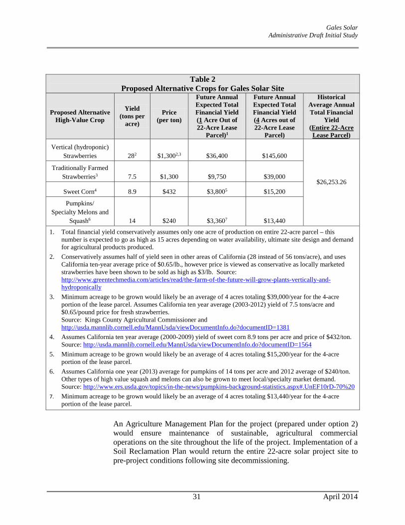
Gales Solar Administrative Draft Initial Study
Table 2 Proposed Alternative Crops for Gales Solar Site
Proposed Alternative High-Value Crop
Yield
(tons per acre)
Price (per ton)
Future Annual Expected Total Financial Yield (1 Acre Out of 22-Acre Lease
Parcel)1
Future Annual Expected Total Financial Yield (4 Acres out of 22-Acre Lease
Parcel)
Historical Average Annual Total Financial
Yield (Entire 22-Acre Lease Parcel)
Vertical (hydroponic) Strawberries 282 $1,3002,3 $36,400 $145,600
$26,253.26
Traditionally Farmed Strawberries3 7.5 $1,300 $9,750 $39,000
Sweet Corn4 8.9 $432 $3,8005 $15,200
Pumpkins/ Specialty Melons and
Squash6 14 $240 $3,3607 $13,440
1. Total financial yield conservatively assumes only one acre of production on entire 22-acre parcel – this number is expected to go as high as 15 acres depending on water availability, ultimate site design and demand for agricultural products produced.
2. Conservatively assumes half of yield seen in other areas of California (28 instead of 56 tons/acre), and uses California ten-year average price of $0.65/lb., however price is viewed as conservative as locally marketed strawberries have been shown to be sold as high as $3/lb. Source: http://www.greentechmedia.com/articles/read/the-farm-of-the-future-will-grow-plants-vertically-and-hydroponically
3. Minimum acreage to be grown would likely be an average of 4 acres totaling $39,000/year for the 4-acre portion of the lease parcel. Assumes California ten year average (2003-2012) yield of 7.5 tons/acre and $0.65/pound price for fresh strawberries. Source: Kings County Agricultural Commissioner and http://usda.mannlib.cornell.edu/MannUsda/viewDocumentInfo.do?documentID=1381
4. Assumes California ten year average (2000-2009) yield of sweet corn 8.9 tons per acre and price of $432/ton. Source: http://usda.mannlib.cornell.edu/MannUsda/viewDocumentInfo.do?documentID=1564
5. Minimum acreage to be grown would likely be an average of 4 acres totaling $15,200/year for the 4-acre portion of the lease parcel.
6. Assumes California one year (2013) average for pumpkins of 14 tons per acre and 2012 average of $240/ton. Other types of high value squash and melons can also be grown to meet local/specialty market demand. Source: http://www.ers.usda.gov/topics/in-the-news/pumpkins-background-statistics.aspx#.UnEF10rD-70%20
7. Minimum acreage to be grown would likely be an average of 4 acres totaling $13,440/year for the 4-acre portion of the lease parcel.
An Agriculture Management Plan for the project (prepared under option 2) would ensure maintenance of sustainable, agricultural commercial operations on the site throughout the life of the project. Implementation of a Soil Reclamation Plan would return the entire 22-acre solar project site to pre-project conditions following site decommissioning.
31 April 2014
Gales Solar Administrative Draft Initial Study
It should be reiterated that the project site constitutes only approximately 5 percent of the total 517-acre area of FSZ Contract No. 00011 and less than one-half of one percent of FSZ contracted land in Kings County.
(2) The use will not significantly displace or impair current or reasonably foreseeable
agricultural operations on the subject contracted parcel or parcels or on other contracted lands in agricultural preserves. Uses that significantly displace agricultural operations on the subject contracted parcel or parcels may be deemed compatible if they relate directly to the production of commercial agricultural products on the subject contracted parcel or parcels or neighboring lands, including activities such as harvesting, processing, or shipping.
To remain Williamson Act compatible and to be in compliance with the project’s conditional use permit, the owner/operator would fully commit to and ensure successful implementation of an Agriculture Management Plan, consistent with the principles of compatibility and performance standards outlined in Government Code section 51238.1. Alternative agricultural operations proposed at the project site for the life of the project would yield a similar or increased, overall economic and productivity return as has historically existed on the subject property (see Tables 1 and 2 above). As shown on both the fixed-tilt and tracking Site Plans, a 4.5-acre “Continuous Agricultural Area” for high-value crops has been incorporated into the site design. This represents approximately 20% of the total 22-acre lease area. In addition, sheep grazing/husbandry activities are proposed on approximately 16.5 acres of the remaining acreage (or a total of almost 95% of the remaining site footprint). The development and operation of the Gales Solar site is self-contained, does not include elements that would facilitate expansion (i.e., over-sized infrastructure), nor does the operation of the project pose harm or create issues of incompatibility with the operation of agricultural activities on adjacent properties. Furthermore, the project site constitutes only approximately 5 percent of the total 517-acre area of FSZ Contract No. 00011.
(3) The use will not result in the significant removal of adjacent contracted land from
agricultural or open-space use.
The site is surrounded by lands containing FSZ and Williamson Act contracts, with the single exception of the small rural residential area north of the project site, consisting of four homes.14 The project site constitutes only approximately 5 percent of the total 517-acre area of FSZ Contract No. 00011 and less than one-half of one percent of FSZ contracted land in Kings County. It would be speculative to assume that the introduction of a 22-acre
14 Kings County. Kings County Agricultural Preserves 2013, Williamson Act & Farmland Security Zone Properties Map. October 8, 2013.
32 April 2014

Gales Solar Administrative Draft Initial Study
solar facility on the project site would lead to removal of adjacent contracted land from agricultural or open space use for similar purposes. The project would be self-contained and would not provide new available infrastructure that could be used by other power generation projects. Moreover, a low likelihood exists for the demand of additional energy projects on nearby farmland, as locating these types of “distributed level” renewable energy projects is physically limited to the (low) capacity on a given electrical distribution line. That is, it is unlikely that additional solar farms can physically be placed in the vicinity due to physical limits to carry electricity on the power lines. Therefore, the proposed use will not induce additional solar generation facilities to site on adjacent parcels. In addition, the solar facility is not an intensive use that would create conflicts with neighboring agricultural operations on contracted lands and somehow lead to the inability of adjacent landowners to continue farming.
Conclusion If the DOC approves the applicant’s request for cancellation of the existing Williamson Act/FSZ contract for the 22-acre lease area, then the project would not conflict with an existing Williamson Act contract. If the DOC does not approve cancellation of the FSZ contract, then the applicant would conduct on-site agricultural operations that would be consistent with the principles of compatibility of California Government Code Section 51238.1, as discussed above in Project Option 2 – Continue Agricultural Operations On-site. By doing so, the project would not conflict with the existing Williamson Act contract over the property. For the above-stated reasons, the project would have a less-than-significant impact with respect to conflicting with existing zoning for agricultural use, or a Williamson Act contract.
II c,d) No Impact. The proposed project site is agricultural land, which is zoned AG-20. The project would not conflict with existing zoning for, or cause rezoning of, forest land (as defined in Public Resources Code section 12220(g)), timberland (as defined by Public Resources Code section 4526), or timberland zoned Timberland Production (as defined by Government Code section 51104(g)).
33 April 2014

Gales Solar Administrative Draft Initial Study
III. AIR QUALITY. Would the project:
Potentially Significant
Impact
Less Than Significant
with Mitigation
Incorporated
Less-Than-
Significant Impact
No Impact
a. Conflict with or obstruct implementation of the applicable air quality plan?
b. Violate any air quality standard or contribute substantially to an existing or projected air quality violation?
c. Result in a cumulatively considerable net increase of any criteria pollutant for which the project region is non-attainment under an applicable federal or state ambient air quality standard (including releasing emissions which exceed quantitative thresholds for ozone precursors)?
d. Expose sensitive receptors to substantial pollutant concentrations?
e. Create objectionable odors affecting a substantial number of people?
III a) Less Than Significant Impact. The proposed project site is located approximately
2.11 miles northeast of the City of Hanford in Kings County, which is within the jurisdictional boundaries of the San Joaquin Valley Air Pollution Control District (SJVAPCD). At the federal level, the jurisdictional area of the SJVAPCD is designated as extreme nonattainment for the 8-hour ozone standard, nonattainment for PM2.5, and attainment or unclassified for all other criteria pollutants. At the State level, the area is designated as severe nonattainment for the one-hour ozone standard, and nonattainment for the 8-hour ozone, PM10, and PM2.5 standards. The area is designated attainment or unclassified for all other State standards. Due to the nonattainment designations, the SJVAPCD has developed plans to attain the State and federal standards for ozone and particulate matter. The plans include the 2013 Plan for the Revoked 1-Hour Ozone Standard, the 2007 Ozone Plan, the 2007 PM10 Maintenance Plan and Request for Redesignation, the 2008 PM2.5 Plan, and the 2012 PM2.5 Plan.
The SJVAPCD thresholds of significance are based on the SJVAPCD source review offset requirements, which are a major component of the SJVAPCD’s air quality plans. Thus, according to the SJVAPCD, projects with emissions below the thresholds of significance for criteria pollutants would be determined not to conflict with or obstruct implementation of the SJVAPCD’s air quality plans. As discussed in further detail below, the proposed project would result in emissions of criteria pollutants that would not exceed the applicable thresholds of significance. Therefore, the proposed project would not be considered to conflict with or obstruct implementation of any applicable air quality plan.
III b,c) Less Than Significant Impact. Typically, construction and operation of a project
generates emissions of various air pollutants, including criteria pollutants such as carbon monoxide (CO), ozone precursors such as nitrous oxides (NOX) and reactive
34 April 2014

Gales Solar Administrative Draft Initial Study
organic gases (ROG) or Volatile Organic Compounds (VOC), particulate matter less than 10 microns in diameter (PM10), and PM2.5, as well as sulfur oxides (SOX). For example, typical emission sources during construction include equipment exhaust, dust from wind erosion, earthmoving activities, and vehicle movements.
To assist in evaluating impacts of project-specific air quality emissions, the SJVAPCD has adopted thresholds of significance for criteria pollutant emissions, expressed in units of tons per year (tons/yr), as presented in Table 3.
Table 3 SJVAPCD Thresholds of Significance
Pollutant Construction Emissions
(tons/yr) Operational Emissions
(tons/yr) ROG 10 10 NOX 10 10 CO 100 100 SOX 27 27 PM10 15 15 PM2.5 15 15
Source: SJVAPCD, May 2012.
Construction-Related Emissions During construction of the project, various types of equipment and vehicles would temporarily operate on the project site. Construction exhaust emissions would be generated from construction equipment, vegetation clearing and earth movement activities, construction workers’ commute, and construction material hauling for the entire construction period. The aforementioned activities would involve the use of diesel- and gasoline-powered equipment that would generate emissions of criteria pollutants. Project construction activities also represent sources of fugitive dust, which includes PM emissions. As construction of the proposed project would generate air pollutant emissions intermittently within the site, and in the vicinity of the site, until all construction has been completed (estimated to be a three-month period), construction is a potential short-term concern because the proposed project is in a nonattainment area for ozone and PM. Construction of the proposed project is estimated to require a maximum of 35 workers who would work in single shifts, five to six days per week. Construction is estimated to start in 2014 and would be completed within approximately three months. An estimated 320 total truck trips (160 round-trips) are anticipated for materials delivery during construction of the proposed project, with a maximum of 24 daily truck trips (12 round-trips). The following pieces of heavy-duty construction equipment and vehicles would be used on the project site during construction:
• 2-3 Ramming Machines; • 1-2 Excavators;
35 April 2014

Gales Solar Administrative Draft Initial Study
• 1-2 Backhoes; • 2-4 Concrete Buggies; and • 4 Passenger Trucks.
Limited site grading is expected for the project (approximately 3,500 square feet) associated with minor cuts at the locations of inverters and other equipment to provide level foundations on properly prepared subgrade. Trenching would be required throughout the project site for the installation of the buried electrical wire (cable) systems, which would range from depths of approximately 18 to 48 inches and would be backfilled with excavated material from the site and compacted. In total, approximately 24,000 linear feet of utility trenching is anticipated on-site. Typically trench backfill and subgrade compaction consists of compaction to 90 percent of maximum density as calculated by ASTM D1557 Modified Proctor. Erosion control BMPs would be implemented during construction to avoid and minimize impacts on the environment during construction. BMP measures to be implemented, include but are not limited to the following, which would help to reduce emissions of construction-related PM:
• A stabilized construction entrance/exit and access route into the site will be maintained at each construction site entrance/exit to reduce tracking of sediment as a result of construction traffic;
• Tire wash racks will be installed if soil and/or traffic conditions on‐site require washing the construction vehicle wheels prior to exiting the site to avoid excessive tracking of mud onto the roadway;
• Road sweeping and vacuuming will occur as necessary to keep street surfaces clear of soil and debris; and
• During windy conditions (forecast or actual wind conditions of approximately 25 mph or greater), dust control will be applied to disturbed areas, including construction access roads. Water will be applied to disturbed soil areas of the project site using water trucks as required by weather conditions to control dust.
The proposed project’s short-term construction emissions were estimated using the California Emissions Estimator Model (CalEEMod) version 2013.2.2 software - a statewide model designed to provide a uniform platform for government agencies, land use planners, and environmental professionals to quantify air quality emissions, including GHG emissions, from land use projects. The model applies inherent default values for various land uses, including trip generation rates based on the ITE Manual, vehicle mix, trip length, average speed, etc. However, as the proposed project is not a typical land use in CalEEMod, project-specific data was input into the model (e.g., construction phases and timing, equipment, vehicle trips, etc.). The proposed project’s unmitigated construction-related emissions have been estimated using CalEEMod and are presented in Table 4.
36 April 2014

Gales Solar Administrative Draft Initial Study
Table 4
Maximum Unmitigated Project Construction-Related Emissions
Pollutant Project Emissions
(tons/yr) SJVAPCD Thresholds of Significance
(tons/yr) ROG 0.10 10 NOX 0.98 10 CO 0.79 100 SOX 0.00143 27 PM10 0.07 15 PM2.5 0.05 15
Source: CalEEMod, January 2014 (see Appendix A).
As shown in the table, the proposed project’s unmitigated construction-related emissions would be well below the SJVAPCD thresholds of significance. It should be noted that the proposed project is required to comply with all SJVAPCD rules and regulations for construction, including, but not limited to, Regulation VIII (Fugitive PM10 Prohibition), Rule 4101 (Visible Emissions), Rule 4601 (Architectural Coatings), and Rule 4641 (Cutback Slow Cure, and Emulsified Asphalt, Paving and Maintenance Operations). Therefore, the proposed project’s construction-related emissions would not result in a significant contribution to the region’s nonattainment status of ozone or PM, and would not violate an air quality standard or contribute substantially to an existing or projected air quality violation. Operational Emissions The solar facility would go online upon completion of construction and would be monitored remotely. Workers would perform routine maintenance three to four times per month during operations – including mowing of grasses and shrubs, as necessary, and PV panel and electrical upkeep. As such, approximately 96 total vehicle trips (48 round-trips) would be made to the project site per year during the long-term operation of the project. Maintenance would likely include periodic washing of solar panels, which would be expected to involve the use of a water truck. The water truck usage is accounted for in the modeling for operational emissions by assuming an additional 24 total vehicle trips per year (12 round-trips) per year, for a total of 120 vehicle trips (60 round-trips) per year during operations. Because the proposed project would be operated remotely and would not involve typical operations that would involve operational fuel combustion, energy usage, waste generation, or water usage, emissions associated with mobile sources would be the primary operational source of air pollutant emissions. In order to ensure that the 120 total vehicle trips per year required for maintenance of the proposed project would not cause ROG, NOX, or any other criteria pollutant emissions to exceed the SJVAPCD’s applicable thresholds of significance or degrade the region’s air quality, the proposed project’s operational emissions were estimated using CalEEMod. As shown in Table 5, the operational emissions of the project would
37 April 2014
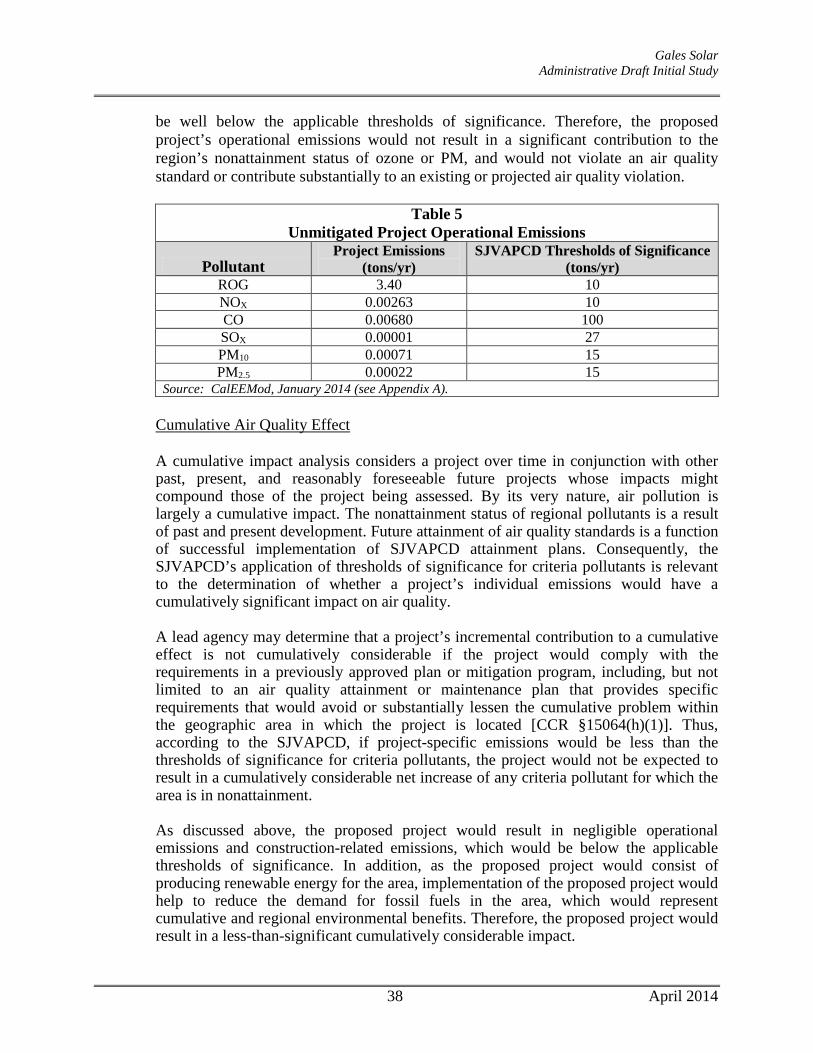
Gales Solar Administrative Draft Initial Study
be well below the applicable thresholds of significance. Therefore, the proposed project’s operational emissions would not result in a significant contribution to the region’s nonattainment status of ozone or PM, and would not violate an air quality standard or contribute substantially to an existing or projected air quality violation.
Table 5 Unmitigated Project Operational Emissions
Pollutant Project Emissions
(tons/yr) SJVAPCD Thresholds of Significance
(tons/yr) ROG 3.40 10 NOX 0.00263 10 CO 0.00680 100 SOX 0.00001 27 PM10 0.00071 15 PM2.5 0.00022 15
Source: CalEEMod, January 2014 (see Appendix A). Cumulative Air Quality Effect A cumulative impact analysis considers a project over time in conjunction with other past, present, and reasonably foreseeable future projects whose impacts might compound those of the project being assessed. By its very nature, air pollution is largely a cumulative impact. The nonattainment status of regional pollutants is a result of past and present development. Future attainment of air quality standards is a function of successful implementation of SJVAPCD attainment plans. Consequently, the SJVAPCD’s application of thresholds of significance for criteria pollutants is relevant to the determination of whether a project’s individual emissions would have a cumulatively significant impact on air quality.
A lead agency may determine that a project’s incremental contribution to a cumulative effect is not cumulatively considerable if the project would comply with the requirements in a previously approved plan or mitigation program, including, but not limited to an air quality attainment or maintenance plan that provides specific requirements that would avoid or substantially lessen the cumulative problem within the geographic area in which the project is located [CCR §15064(h)(1)]. Thus, according to the SJVAPCD, if project-specific emissions would be less than the thresholds of significance for criteria pollutants, the project would not be expected to result in a cumulatively considerable net increase of any criteria pollutant for which the area is in nonattainment. As discussed above, the proposed project would result in negligible operational emissions and construction-related emissions, which would be below the applicable thresholds of significance. In addition, as the proposed project would consist of producing renewable energy for the area, implementation of the proposed project would help to reduce the demand for fossil fuels in the area, which would represent cumulative and regional environmental benefits. Therefore, the proposed project would result in a less-than-significant cumulatively considerable impact.
38 April 2014

Gales Solar Administrative Draft Initial Study
Conclusion Emissions from the proposed project would be below the applicable thresholds of significance during both construction and operations. Accordingly, the project would not be expected to result in a cumulatively considerable net increase of any criteria pollutant for which the area is in nonattainment. In addition, as the proposed project would consist of producing renewable energy for the area, implementation of the proposed project would help to reduce the demand for fossil fuels in the area, which would represent cumulative and regional environmental benefits. Overall, the proposed project would not violate an air quality standard, contribute substantially to an existing or projected air quality violation, or result in a cumulatively considerable net increase of any criteria pollutant.
III d) Less Than Significant Impact. Localized concentrations of CO are related to the
levels of traffic and congestion along streets and at intersections. Concentrations of CO approaching the ambient air quality standards are only expected where background levels are high, and traffic volumes and congestion levels are high. Implementation of the proposed project, and the 120 total annual vehicle/truck trips associated with operations, would not result in a substantial increase in traffic on area roadways. Thus, operation at all nearby roadways and intersections would not be degraded as a result of the proposed project. Therefore, the project’s impact related to a contribution to localized mobile-source concentrations of CO would be less than significant.
Another category of environmental concern is TACs. The CARB’s Air Quality and Land Use Handbook: A Community Health Perspective (Handbook) provides recommendations for siting new sensitive land uses near sources typically associated with significant levels of TAC emissions, including, but not limited to, freeways and high traffic roads, distribution centers, and rail yards. The CARB has identified DPM from diesel-fueled engines as a TAC; thus, high volume freeways, stationary diesel engines, and facilities attracting heavy and constant diesel vehicle traffic are identified as having the highest associated health risks from DPM. Health risks from TACs are a function of both the concentration of emissions and the duration of exposure. Health-related risks associated with DPM in particular are primarily associated with long-term exposure and associated risk of contracting cancer. The project site is not located near any substantial sources of TACs, such as distribution centers with more than 100 trucks per day, rail yards, high volume roadways, or freeways. In addition, the proposed project would not introduce new sensitive receptors to the area and would be operated remotely. Therefore, the proposed project would not be affected by any existing sources of TACs. Operations of the proposed project would not involve long-term operation of any stationary diesel engine or other major on-site stationary source of TACs. In addition, electricity generation via the use of photovoltaic systems does not generate chemical emissions that would negatively contribute to air quality. Construction activities,
39 April 2014
Gales Solar Administrative Draft Initial Study
however, have the potential to generate DPM emissions related to the number and types of equipment typically associated with construction. Off-road heavy-duty diesel equipment used for site grading, paving, and other construction activities result in the generation of DPM. The existing residence located on the subject parcel, immediately west of the proposed solar facility area, would be the closest sensitive receptor to the site and could become exposed to DPM emissions from the site during construction activities. However, construction is temporary and occurs over a relatively short duration in comparison to the operational lifetime of the proposed project (i.e., construction anticipated to be accomplished within three months). In addition, heavy-duty construction equipment would not operate continuously, but intermittently throughout the course of a day over the entire project site, and would be regulated. As construction equipment on-site would not operate for long periods of time and would be used at various locations within the site, not always the same location for long periods of time, the likelihood that any one sensitive receptor would be exposed to high concentrations of DPM for any extended period of time would be very low. Because health risks associated with exposure to DPM or any TAC are correlated with high concentrations over a long period of exposure (e.g., over a 70-year lifetime), the temporary, intermittent construction-related DPM emissions would not be expected to cause any health risks to nearby sensitive receptors. Furthermore, as discussed above, substantial emissions of pollutants in excess of applicable thresholds of significance would not result from implementation of the project. Overall, the proposed project would not generate emissions of, or expose any nearby existing sensitive receptors to TACs. For the reasons discussed above, the proposed project would not cause or be exposed to substantial pollutant concentrations, including localized CO or TACs. Therefore, impacts related to exposure of sensitive receptors to substantial pollutant concentrations would be less than significant.
III e) No Impact. Due to the subjective nature of odor impacts, the number of variables that
can influence the potential for an odor impact, and the variety of odor sources, quantitative or formulaic methodologies to determine the presence of a significant odor impact do not exist. The intensity of an odor source’s operations and its proximity to sensitive receptors influences the potential significance of odor emissions. Common types of facilities that have been known to produce odors in the San Joaquin Valley include, but are not limited to, wastewater treatment facilities, landfills, composting facilities, petroleum refineries, food processing facilities, feed lots, and/or dairies. The proposed project does not involve any of the aforementioned facilities, and electricity generation via the use of photovoltaic systems would not generate chemical emissions that would negatively contribute to air quality or create objectionable odors. In addition, the proposed project would not introduce any new sensitive receptors to the area that could be affected by any existing objectionable odor sources in the area. Therefore, operation of the proposed project would not create objectionable odors affecting a substantial number of people.
40 April 2014

Gales Solar Administrative Draft Initial Study
Diesel fumes from construction equipment are often found to be objectionable; however, as discussed in further detail above, construction is temporary and associated diesel emissions would be regulated. As such, substantial levels of DPM associated with the temporary, intermittent construction activities would not be expected at the nearest sensitive receptor. Thus, odors related to DPM from construction equipment would not be expected to be considerable or affect a substantial number of people.
For the aforementioned reasons, construction and operation of the proposed project would not create objectionable odors, nor would the project site be affected by any existing sources of objectionable odors, and a less-than-significant impact related to objectionable odors would result.
41 April 2014

Gales Solar Administrative Draft Initial Study
IV. BIOLOGICAL RESOURCES. Would the project:
Potentially Significant
Impact
Less Than Significant
with Mitigation
Incorporated
Less-Than-
Significant Impact
No Impact
a. Have a substantial adverse effect, either directly or through habitat modifications, on any species identified as a candidate, sensitive, or special status species in local or regional plans, policies, or regulations, or by the California Department of Fish and Game or U.S. Fish and Wildlife Service?
b. Have a substantial adverse effect on any riparian habitat or other sensitive natural community identified in local or regional plans, policies, and regulations or by the California Department of Fish and Game or US Fish and Wildlife Service?
c. Have a substantial adverse effect on federally protected wetlands as defined by Section 404 of the Clean Water Act (including, but not limited to, marsh, vernal pool, coastal, etc.) through direct removal, filling, hydrological interruption, or other means?
d. Interfere substantially with the movement of any resident or migratory fish or wildlife species or with established resident or migratory wildlife corridors, or impede the use of wildlife nursery sites?
e. Conflict with any local policies or ordinances protecting biological resources, such as a tree preservation policy or ordinance?
f. Conflict with the provisions of an adopted Habitat Conservation Plan, Natural Conservation Community Plan, or other approved local, regional, or state habitat conservation plan?
IV a) Less Than Significant with Mitigation Incorporated. The Aspen Environmental Group
prepared a Biological Resources Report for the Gales Solar project to assess on-site habitat conditions and determine if the project site has the potential to support special-status plant and wildlife species (see Appendix C). Barnett Environmental Group also assisted by performing a Swainson’s hawk foraging habitat analysis.
Aspen first reviewed available literature to identify special-status plants, wildlife, or plant communities known from the project vicinity, including but not limited to a review of the California Natural Diversity Database (CDFW 2013) for USGS 7.5-minute Burris Park, Goshen, Guernsey, Hanford, Laton, Paige, Remnoy, Traver, and Waukena USGS topographic quadrangles. They also reviewed the California Native Plant Society (CNPS) On-line Electronic Inventory (CNPS 2013) for the quadrangles listed above, and searched
42 April 2014

Gales Solar Administrative Draft Initial Study
the Consortium of California Herbaria (2013) for records of special-status plants known from the area. Aspen then visited the project area on January 17, 2013 and walked all access roads within and surrounding the site. They used binoculars to survey the site from roadsides, and drove all accessible roads within 0.5-mile of the property to locate potential Swainson’s hawk (Buteo swainsoni), nest sites, per Swainson’s Hawk Technical Advisory Committee (2000) survey guidelines.
Special-status Plants
Seven CNPS special-status plant species (rare in California and elsewhere [1B] or rare in California, but common elsewhere [2B]) have been documented within these USGS quads, but none on these CNPS lists or otherwise listed as threatened, endangered, or with some other special-status have the potential to be present on-site due to lack of suitable habitat (e.g., lack of suitable alkali, saline, or clay soils; lack of vernal pool habitat). Aspen bases this conclusion, however, on habitat suitability rather than observational records, as they conducted the field survey outside the flowering seasons for most plants – during the winter of 2012/2013.
Special-status Wildlife
Aspen concluded that only two of fourteen threatened or endangered wildlife species previously reported within the nine USGS 7.5-minute quads surrounding the project site, could occur on-site, based on available habitats and/or closest known records. These include the San Joaquin kit fox (Vulpes macrotis mutica; federal endangered/CA threatened) and Swainson’s hawk (Buteo swainsoni; CA threatened). Aspen also concluded that six California wildlife species of concern could also be present, including:
1. Three California bird species of concern – the western burrowing owl, loggerhead shrike, and tricolored blackbird; and
2. Three California bat species of concern – Townsend’s big-eared bat, western mastiff bat and silver-haired bat.
The project site, however, does not provide appropriate habitat for any of the above-mentioned species, with the exception of Swainson’s hawk discussed below (a full discussion of each species can be found in Aspen’s April 2013 Biological Resources Technical Report).
Swainson’s hawk The Swainson’s hawk is a California Threatened species that can be found throughout the general project area during the breeding season (April 1 – August 1). Swainson’s hawks nest in native valley oak (Quercus lobata) and other trees, including native and non-native species, such as ornamental trees and windrows near developments, roads, and agricultural lands. Swainson’s hawks feed primarily on meadow voles (Microtus
43 April 2014

Gales Solar Administrative Draft Initial Study
californicus) but also on a variety of other small mammals, small birds, reptiles, and insects. The hawk forages wherever food is available, especially in croplands, and can travel up to 14 miles from their nests to forage. Foraging habitats include alfalfa fields, fallow fields, beet, tomato, and other low-growing row or field crops, dry-land and irrigated pasture, and rice land when not flooded (CDFG 1994). Development of the 22-acre project site could therefore result in adverse impacts to Swainson’s hawk foraging habitat. It should be noted that the CDFW has a published policy that applicants shall mitigate or otherwise compensate for impacts to Swainson’s hawk foraging habitat.
Several nesting sites have been documented within five miles of the project site; the nearest recorded nest is located 3.3 miles southeast of the site (CDFW 2013). There are no trees on the site, however, that could provide suitable nesting habitat, though Aspen biologists observed several trees within the surrounding area that may be suitable for nesting, including valley oaks and other ornamental trees. All of these trees were leafless (due to season), and any nests present would have been visible. Aspen did not observe large stick nests characteristic of Swainson’s hawks in any of these trees. The following analysis of the proposed project’s impacts on available Swainson’s hawks foraging habitat within a 10-mile radius of the project is based on Jim Estep’s 2011 study of The Distribution and Abundance of Nesting Swainson’s Hawks in the Vicinity of the Proposed RE Kansas South LLC Solar Generation Facility. The Kansas South LLC Solar Project is approximately 19 miles southwest of the proposed Gales Solar project.
Nesting density As the current project is only about five (5) miles outside of Estep’s (2011; 10-mile radius) study area, it is assumed that his conclusion of approximately 0.05 active nest sites per square mile (0.13 per sq km) is equally applicable to the Gales Solar project vicinity. This is a very low nesting density compared with the Sacramento Valley breeding population and lower than most other portions of the hawk’s breeding range (Table 6).
Table 6 Nesting Density within the Gales Solar Project Vicinity Area Relative to Other
Geographic Areas.
Estep’s (2011) review of an approximately 900,000-acre study area adjacent to the Kansas Solar project, which includes eight additional, proposed projects, reveals similar
44 April 2014

Gales Solar Administrative Draft Initial Study
results with an estimated density of 0.07 nesting territories per square mile (0.17 per square km).
Foraging Habitat Distribution Within a 10-mile radius of the proposed Gales Solar project (see Table 7), lands uses suitable for Swainson’s hawk foraging include irrigated croplands, alfalfa and other hay fields, irrigated pasture, and natural lands. A total of 170,534 acres (68%) of the study area can therefore be considered suitable Swainson’s hawk foraging habitat.
Table 7 Land use acreage totals within 10 miles of Gales Solar Project Area
*source: CA Dept. Water Resources Land Use Data for: Kings County (2003); Tulare County (2007); and Eastern Fresno County (2009). (http://www.water.ca.gov/landwateruse/lusrvymain.cfm)
Annually or seasonally cultivated and rotated crops dominate approximately 42% of the land area within 10 miles of the proposed project. These irrigated crops have seasonal or fluctuating foraging habitat value depending on the planting and harvesting regime and vegetation height and density (Estep 2009). Rodent populations generally increase during planting, their accessibility (and consequently Swainson’s foraging use of these fields) decreases as the crop matures (Bechard 1982, Estep 2009), but again increases during the harvest, when rodent populations are at their highest and foraging by hawks reaches a peak. Some crops, such as cotton and corn, have limited value because their structure precludes foraging relatively early in the breeding season, prey populations are generally lower in these crop types, and harvesting often occurs after Swainson’s hawks have begun fall migration. Overall however, irrigated croplands have at least moderate foraging value due to the matrix of different crop types across the agricultural landscape, the seasonal value of certain types such as tomatoes and wheat, and the seasonal or annual rotation practices. Alfalfa has the highest Swainson’s hawk foraging value due to its relatively low height, regular mowing (once/month) and flood irrigating (once/week) during the breeding season, which tend to flush rodent prey from underground and make them more accessible to the hawks.
45 April 2014

Gales Solar Administrative Draft Initial Study
The combination of abundant nesting habitat and a diverse agricultural matrix with high foraging value (to the hawks) crop types within the project vicinity could support an abundance of nesting Swainson’s hawks and directly affect their distribution on the landscape.
Use of the Project Vicinity by Foraging Swainson’s Hawks From the documented availability of high-value foraging habitat within the project vicinity and knowledge of Swainson’s hawk foraging use patterns in the Central Valley (Estep 1989, Babcock 1995), it is possible to qualitatively describe the likely use of the project vicinity by the (assumed, based on Estep 2011) approximately 19 nesting pairs that reside within it. It is reasonable to assume that Swainson’s hawks nesting in the project vicinity also likely forage in this area because of the extent of alfalfa and other higher value crop types, even though they can easily travel significant distances from their nest sites to forage when opportunities occur.
Project Impact A conservative threshold is being applied for this analysis, defined as whether or not the project would affect the existing distribution and abundance, or affect the future expansion of the local Swainson’s hawk breeding population. The impact would therefore be significant if the project reduces available Swainson’s hawk nesting or foraging habitat and in turn reduces the nesting population’s distribution or abundance or otherwise prevents expansion of the population. Conversely, the impact would be considered less than significant if the project’s removal or alteration of nesting or foraging habitat would not reduce the distribution or abundance of the existing population or prevent expansion of that population.
Nesting Habitat Impact There are no trees on the project site so the proposed project would not remove or even likely disturb any nesting or potential Swainson’s hawk nesting habitat. The nearest known active nest is seven to eight miles west-southwest of the project site – south of State Route 198, east of Lemoore (Estep 2011). This is far enough from the Gales Solar project site to avoid any disturbance-related impacts on nesting Swainson’s hawks.
Foraging Habitat Impact Determining whether or not the loss of 22 (of the site’s total of 28) acres of agricultural foraging habitat exceeds the significance threshold previously described can be done by reviewing: (1) Estep’s 2011 survey work and the current project vicinity’s habitat/land use data to estimate an existing baseline condition expressed as foraging habitat availability; and (2) the known requirements of foraging Swainson’s hawks in the Central Valley to estimate the extent of suitable agricultural foraging habitat required to support a Swainson’s hawk population equivalent to that evaluated by Estep (2011), as the project
46 April 2014

Gales Solar Administrative Draft Initial Study
area is immediately adjacent to his study area and an assumption of population equivalence should therefore be valid. Table 8 below indicates the acres of suitable agricultural foraging habitat within a 10-mile radius of the project area, the amount of agricultural foraging habitat required to support 19 nesting pairs of Swainson’s hawks (from Estep 1989), the number of acres that exceeds the estimated amount required, the number of acres removed by the project, and the acres and percent remaining following implementation of the project.
Table 8 Total acres of available, required, and impacted agricultural foraging habitat within
10 miles of the Gales Solar solar project.
The average size of a Swainson’s hawk foraging range is 6,820 acres (from Estep, 1989). This equates to a total of 129,580 acres required to support the 19 nesting pairs. Incorporating the 40% overlap in foraging ranges estimated by Estep (1989), but reducing this to 30% because of (assumed) less overlap for the more isolated nesting pairs likely found in this portion of their range, the total required for the 19 nesting pairs encountered in Estep’s 2011 study (and therefore also assumed in this discussion) is 90,706 acres. It therefore appears that there is far more available foraging habitat in the project vicinity than normally required to support an existing Swainson’s hawk population of the size likely to occur in this area (Estep, 2011). Table 8 indicates that there is twice the available foraging habitat in the study area than is required by the existing Swainson’s hawk nesting population and that the amount removed from project implementation would not affect the distribution and abundance of this population – 99.9% of the surplus available acreage will remain following implementation of the project and thus the project would not prevent future expansion of this population. Since Swainson’s hawk foraging patterns change with changes in crop patterns, one could conservatively assume that the amount of available surplus acres must be reduced below (an arbitrary, but sound assumption of) 70% of the total surplus to be considered significant. Consequently, if available foraging habitat acres exceed that required by the population and at least 70% of the remaining surplus suitable acres are retained, then the extent of habitat removal is not expected to affect either the existing population or
47 April 2014

Gales Solar Administrative Draft Initial Study
substantially affect the opportunities for expansion of the population and the impact of this project would thus be considered less than significant. Even assuming a substantial variability in foraging range sizes, there still remains more available habitat than required within this assessment area and the project would have only a negligible effect (<1%) on surplus habitat. Thus, clearly the conversion of 22 available acres of agricultural land on the project site will not adversely affect the distribution and abundance of nesting Swainson’s hawks nor would it prevent an expansion of this population. Thus, this impact must be considered less than significant.
Cumulative Impact To determine the contribution of the project to a larger possible impact on the species, lands within a 10-mile radius of the proposed project were used as the cumulative impact assessment area. Including the Gales Solar project, there are currently four proposed projects within the study area (two in Kings County, two in Tulare County) totaling 75 acres of potential foraging habitat impact, or approximately 0.03% of that available in the current (20-mile diameter) assessment area. Using a similar method as described above, 99.9% of the total available foraging habitat and 99.9% of the surplus portion remain as suitable habitat following implementation of all projects (Table 9). Consequently, the cumulative loss of suitable agricultural habitat does not reach the threshold for significance and the impact is therefore less than significant.
Table 9 Total acres of available, required, and cumulatively impacted agricultural foraging
habitat within the Gales Solar assessment area.
Special-Status Bats Aspen identified three California bat species of special concern with a potential to occur in the project area – Townsend’s big-eared bat, western mastiff bat, and silver-haired bat. These species require mature trees, snags, crevices, or man-made structures (such as buildings) for roosting, either for winter roosting (hibernacula) or for forming nursery colonies. Roosting structures are not located on the 22-acre solar site. While roosting
48 April 2014

Gales Solar Administrative Draft Initial Study
habitat may be present in the trees and storage shed appurtenant to the residence located immediately west of the boundaries of the 22-acre solar site, the project would not impact these structures. And while the project site may provide suitable foraging habitat for these bat species, any loss of such habitat is considered less than significant for these species because of an abundance of similar habitat both locally and regionally.
San Joaquin Kit Fox The San Joaquin kit fox is a federally Endangered and California Threatened species. No kit fox dens were found on-site during field surveys and the species would not be expected to den on-site due to regular, ongoing, agricultural disturbance. Monitoring of the site between agricultural clearing and construction would ensure that no San Joaquin kit fox den on-site prior to onset of construction (see below mitigation). Loss of kit fox foraging habitat is considered less than significant under CEQA, though recommended mitigation for Swainson’s hawk foraging habitat would also provide additional San Joaquin kit fox habitat.
Other Migratory Birds
Migratory birds, protected under the Migratory Bird Treaty Act, have the potential to (ground) nest or forage within the project site and the Migratory Bird Treaty Act (50 CFR 10.13) prohibits “take” (i.e., direct or indirect activities that cause avian mortality including their eggs and young) of any species listed under this Act. Nests, eggs, and/or young of all nesting birds are also protected under California Fish and Game Code Sections 3503. A preconstruction survey should be adequate to confirm that no migratory birds are nesting prior to onset of ground disturbance activities (see below mitigation).
Conclusion The project would not result in adverse impacts to special-status plant species. Aspen has concluded that no listed threatened or endangered plants, or other special-status plants, have the potential to be present on-site due to lack of suitable habitat (e.g., lack of suitable alkali, saline, or clay soils; lack of vernal pool habitat). The project site does not contain suitable habitat for the majority of special-status wildlife species that have the potential to occur in the area. However, a preconstruction survey would be required to confirm that no special-status species, or migratory bird species, are occupying the site prior to initiation of ground disturbance activities. Therefore, without implementation of mitigation measures, development of the project could result in a potentially significant effect, either directly or through habitat modifications, on any species identified as a candidate, sensitive, or special status species in local or regional plans, policies, or regulations, or by the California Department of Fish and Wildlife or U.S. Fish and Wildlife Service.
49 April 2014

Gales Solar Administrative Draft Initial Study
Mitigation Measures Implementation of the following mitigation measures would reduce the above-identified impacts to biological resources to a less-than-significant level.
Preconstruction Survey Requirement MM IV-1 A qualified biologist shall conduct a preconstruction clearance survey
for special-status species and migratory birds in all potential habitats throughout the project area; thus, any action that disrupts surface soils (e.g., clearing and grubbing, rough grading, excavation, compaction for temporary staging areas or permanent construction sites) shall be subject to a preconstruction survey. Surveys shall be undertaken not more than 30 days prior to ground disturbing activity to ensure avoidance during construction. All areas within 250 feet of the project area shall be surveyed where site access and visibility allows. If no special-status species or migratory birds are present, further mitigation is not necessary. If any special-status species and/or migratory birds are found nesting on-site, the biologist shall implement protective measures to ensure that animals are not adversely affected, and construction does not commence until the biologist has determined no harm would result to breeding animals as a result of construction. Written results of the preconstruction survey shall be submitted to the Kings County Community Development Agency.
Wildlife Fencing MM IV-2 The project security fence shall have a continuous 5-inch opening
between the fence mesh and the ground, or the fence shall be raised 5 inches above the ground, to allow possible passage for kit fox and smaller fauna. The bottom of the fence fabric shall be knuckled (wrapped back to form a smooth edge) to protect wildlife that passes under the fence. The design details shall be reflected on the Improvement Plans for the project, prior to their approval by the Community Development Agency.
IV b) No Impact. The project will have no adverse impacts on sensitive or regulated habitat
because the project site is devoid of native riparian vegetation or other sensitive natural community identified in local or regional plans, policies, regulations, or by the CDFW or USFWS. In addition, none of the irrigation channels identified bordering the project site is vegetated with riparian shrubs or trees.
IV c) No Impact. No waters or wetlands that fall under the jurisdiction of the U.S. Army Corps
of Engineers (ACOE), California Regional Water Quality Control Board (RWQCB), and/or CDFW are found on the project site (Aspen Environmental, 2013). Indicators of hydrologic activity (topographical or geological), hydric soils, or hydrophytic vegetation were not observed on-site. Therefore, no impact would occur.
50 April 2014

Gales Solar Administrative Draft Initial Study
IV d) Less Than Significant Impact. The project could impact San Joaquin kit fox movement
patterns throughout the area by fencing potential movement routes. However, according to the biological resources report prepared for the project site, the site is surrounded by unobstructed movement habitat and is not located within a linkage area between important habitat areas or resources. Due to availability of movement routes throughout the project vicinity, project impacts to San Joaquin kit fox movement routes would be less than significant under CEQA. Furthermore, Mitigation Measure IV-3 requires openings in project fencing to allow possible passage of kit fox.
The proposed project will not interfere substantially with the movement of any other native resident or migratory fish or wildlife species or with established native resident or migratory wildlife corridors, or impede the use of native wildlife nursery sites. The site-specific biological assessment did not identify distinct wildlife corridors or nursery sites within or near the project site.
IV e) Less Than Significant Impact. Construction and operation of the project would not conflict with any local policies or ordinances protecting biological resources. The local authority for the project area is detailed in the provisions of the 2035 Kings County General Plan. Objectives in the Resource Conservation Element of the General Plan address the preservation of environmentally sensitive areas that have existing natural watercourses, drainage basins, sloughs, or other natural water features, including maintaining the quality of existing wetland areas. Other than conserving native oaks and native trees associated with rivers, creeks, and streams, no specific tree preservation ordinances exist for the project area. Activities associated with the operation and maintenance of the proposed project would have no impact on sensitive biological resources protected by local ordinances.
IV f) No Impact. Kings County does not currently have an adopted Habitat Conservation Plan
HCP. Therefore, construction and operation of the proposed project would not conflict with any government-originated local, regional, or state-level habitat conservation plans.
51 April 2014

Gales Solar Administrative Draft Initial Study
V. CULTURAL RESOURCES. Would the project:
Potentially Significant
Impact
Less Than Significant
with Mitigation
Incorporated
Less-Than-
Significant Impact
No Impact
a. Cause a substantial adverse change in the significance of a historical resource as defined in Section 15064.5?
b. Cause a substantial adverse change in the significance of a unique archaeological resource pursuant to Section 15064.5?
c. Directly or indirectly destroy a unique paleontological resource on site or unique geologic features?
d. Disturb any human remains, including those interred outside of formal cemeteries.
This section is based on the site-specific cultural resources report prepared by Aspen Environmental Group, which is entitled Cultural Resources Identification and Evaluation, Gales Photovoltaic Solar Electric Generating Facility (March 2013). V a-d) Less Than Significant with Mitigation Incorporated. The Gales project area is located
within the vast traditional territory claimed by the California Native American group known as the Yokuts. Anthropologists use this name to refer to a large and diverse group of Penutian language speakers who inhabited the San Joaquin Valley and the Sierra Nevada foot-hills of central California. Anthropologically, the Yokuts are divided into three groups based on geographical location: Northern Valley, Foothill, and Southern Valley. The Southern Valley Yokuts territory was centered near the basins of the Tulare, Buena Vista, and Kern lakes, their connecting sloughs, and the lower portions of the Kings, Kaweah, Tule, and Kern Rivers. These Southern Valley Yokuts, and more specifically the Tachi-Yokuts, would have likely been located in the project area during the ethnographic past. Tribal Consultation
On January 10, 2013, Aspen submitted a written request to the Native American Heritage Commission (NAHC) for a records search in the Commission’s Sacred Lands File. Following the NAHC’s recommendations, Aspen contacted a total of seven Native American representatives in the region in writing and by telephone, beginning February 5, 2013, to solicit local Native American input regarding possible cultural resources concerns over the proposed project. On February 21, 2013 a letter from the Santa Rosa Rancheria was received indicating that the Tribe would like to formally request a site visit with Belectric, and expressed concern over the potential of buried resources at the project site. The Tribe recommended a cultural sensitivity class taught by the Tribe for the construction crew and/or construction monitoring by Native Americans. Additionally, the Tribe would like to have a reburial agreement in place, as well as a curation agreement for any artifacts that are discovered during construction (per CEQA Guidelines, California Code of Regulations, Title 14, Section 15064.5). A letter dated
52 April 2014

Gales Solar Administrative Draft Initial Study
February 21, 2013 was received from the Table Mountain Rancheria, which stated that the project area is outside of their area of concern.
California Historical Resources Information System A search of the California Historical Resources Information System (CHRIS) for the project site and vicinity was conducted by staff at the Southern San Joaquin Valley Information Center (SSJVIC) at California State University Bakersfield as part of the Cultural Resources Report. The search covered the areas proposed for the main project components with a 1-mile buffer. According to the CHRIS, cultural resource surveys have not been conducted within the boundaries of the project area, and archaeological sites have not been identified in the project area. One (1) cultural resource survey has been conducted within one (1) mile of the project site, but no sites were recorded. Additionally, about 1.75 miles south of the Gales project area, small segments of the Settler’s Ditch and Melga Canal, the historic canals adjacent to the project area, have been recorded and evaluated.
Field Survey Aspen cultural resource specialists Matthew Braun, MA, and Robin Connors, MA, RPA, conducted a pedestrian survey of the project site on January 29, 2013. The Aspen team examined the ground surface for the presence of prehistoric artifacts (e.g., flaked stone tools, tool-making debris, stone milling tools), historic artifacts (e.g., metal, glass, ceramics), sediment discolorations that could indicate the presence of cultural features (e.g., midden, hearths), and depressions or other features that could indicate the presence of structures or foundations (e.g., post holes, foundations). Historic resources were not identified by the Aspen team within the project area. However, two historic agricultural irrigation canals were noted in the vicinity of the project area. One of these canals, the Melga Canal (P-16-000126), is located adjacent to the eastern boundary of the project area. A segment of this canal has been formally documented by other researchers; however, the segment of the canal in the vicinity of the project area has not yet been recorded. The formal documentation of Melga Canal recommended that the resource is potentially eligible for listing in the NRHP and CRHR as a contributing element to the People’s Ditch System. The canal was constructed as early as 1913, and was developed as a way to distribute water from the People’s Ditch, a canal built in the 1870s. The People’s Ditch connects to the Melga Canal about 2 miles north of the project area, slightly south of the intersection of 7th and Excelsior Avenues. Melga Canal continues in a southerly direction for about 20 miles, and eventually empties into the Tule Lake Canal, about 5 miles west of Corcoran. Formally recording the segment near the project area was beyond the scope of the current project. However, Aspen noted that this segment is an unlined earthen construction with a trapezoidal-shaped cross-section, and slightly bermed sides. The segment of the canal examined by Aspen was approximately 46 feet (14 meters) wide across the top, 16.5 feet (5 meters) wide along the bottom, and approximately 9 feet (5.4 meters) deep.
53 April 2014
Gales Solar Administrative Draft Initial Study
Settlers Ditch (P-16-000127) is also located near the Gales project area. This canal is situated on the western side of 7th Avenue, less than 100 feet west of the project area. A segment of this canal has been formally documented by other researchers; however, the segment of the canal in the vicinity of the project area has not yet been recorded. Two previous formal recordings of Settlers Ditch have occurred; 1) the first evaluation in 1998 recommended that the site is not eligible for listing in the NRHP or CRHR; 2) the update to the site in 2001 revised this recommendation to conclude that the ditch is potentially eligible for listing as a contributing element to the Peoples Ditch System. The Settlers Ditch was constructed in 1888 to divert water from Peoples Ditch for irrigation use. The Peoples Ditch connects to Settlers Ditch about 4 miles north of the project area, southeast of the intersection of 6th and Denver Avenues. Settlers Ditch continues in a southerly direction for about 2.5 miles where it intersects Lakeside Ditch, southeast of the intersection of 8th Avenue and Lacey Boulevard. Formally recording the segment near the project area is beyond the scope of the current project. However, Aspen noted that the canal segment is an unlined earthen construction with a trapezoidal cross-section, and slightly bermed sides. The segment of the canal examined by Aspen was approximately 25 feet (7.5 meters) wide at the top, 9.8 feet (3 meters) wide at the bottom, and about 7.8 feet (2.4 meters) deep. Conclusions
Melga Canal, an agricultural irrigation canal, is located adjacent to the eastern boundary of the project site; and a portion of this canal – 1.75 miles south of the project site - has been formally documented with the recommendation that the feature is potentially eligible for listing in the NRHP and CRHR as a contributing element to the Peoples Ditch System. While the portion of the Melga Canal located adjacent to the project site has not been formally evaluated, the project has been designed to avoid impacting this off-site Canal. Therefore, further evaluation of this off-site feature is not warranted. The archaeological resources survey performed for the project site did not reveal the presence of any on-site resources. Given the disturbed nature of the project site due to ongoing agricultural operations, the likelihood of discovering archaeological resources during construction is remote. However, this possibility cannot be entirely dismissed. Implementation of the following mitigation measures would ensure that the project would not result in adverse impacts to unknown archaeological resources, including human remains, resulting in a less-than-significant impact.
Mitigation Measures Implementation of the following mitigation measures would reduce the above-identified impacts to cultural resources to a less-than-significant level.
MM V-1 Should previously unidentified cultural resources be discovered during
construction of the project, the project sponsor shall cease work within 100 feet of the resources, and Kings County Community Development Agency shall be notified immediately. The project proponent shall retain
54 April 2014
Gales Solar Administrative Draft Initial Study
a professional archaeologist to assess the significance of the find and make mitigation recommendations, if warranted. The archaeologist shall be required to submit to the County for review and approval a report of the findings and method of curation or protection of the resources. Further grading or site work within the area of discovery shall not be allowed until the preceding steps have been taken.
MM V-2 Pursuant to State Health and Safety Code §7050.5 (c) State Public
Resources Code §5097.98, if human bone or bone of unknown origin is found at any time during on- or off-site construction, all work shall stop in the vicinity of the find and the Kings County Coroner shall be contacted immediately. If the remains are determined to be Native American, the coroner shall notify the Native American Heritage Commission who shall notify the person believed to be the most likely descendant. The most likely descendant shall work with the applicant to develop a program for re-internment of the human remains and any associated artifacts. Additional work cannot take place within the immediate vicinity of the find until the identified appropriate actions have been implemented.
MM V-3 Prior to initiation of ground breaking activities, the applicant shall
conduct a site visit in concert with the Santa Rosa Rancheria in order to provide an opportunity for the Rancheria to assess the site and discuss their recommendations. A written summary of the meeting shall be submitted to the Kings County Community Development Agency prior to initiation of groundbreaking activities.
55 April 2014

Gales Solar Administrative Draft Initial Study
VI. GEOLOGY AND SOILS. Would the project:
Potentially Significant
Impact
Less Than Significant
with Mitigation
Incorporated
Less-Than-
Significant Impact
No Impact
a. Expose people or structures to potential substantial adverse effects, including the risk of loss, injury, or death involving:
i. Rupture of a known earthquake fault, as delineated on the most recent Alquist-Priolo Earthquake Fault Zoning Map issued by the State Geologist for the area based on other substantial evidence of a known fault?
ii. Strong seismic ground shaking? iii. Seismic-related ground failure, including liquefaction?
iv. Landslides? b. Result in substantial soil erosion or the loss of
topsoil?
c. Be located on a geologic unit or soil that is unstable, or that would become unstable as a result of the project, and potentially result in on- or off-site landslide, lateral spreading, subsidence, liquefaction or collapse?
d. Be located on expansive soil, as defined in Table 18-1-B of the Uniform Building Code (1994), creating substantial risks to life or property?
e. Have soils incapable of adequately supporting the use of septic tanks or alternative wastewater disposal systems where sewers are not available for the disposal of wastewater?
This section is based upon the geotechnical report prepared for the project site by Holdrege & Kull, entitled, Geotechnical Engineering Report for Gales Photovoltaic Facility, 7th Avenue, Kings County, dated April 9, 2013. VI ai,ii) Less Than Significant Impact. Kings County has no known major fault systems
within its territory. Holdrege & Kull (H&K) reviewed the United States Geological Survey (USGS) online Quaternary Fault and Fold Database of the United States and the California Geological Survey (CGS) 2010 Fault Activity Map of California. The USGS database and CGS 2010 Map indicate that the nearest fault with evidence of movement is the Nunez fault, approximately 50 miles west-southwest of the project site near the town of Coalinga. This fault is considered to be historically active with an earthquake rupture as recent as 1983. The San Andreas fault zone is approximately 15 miles west of the Nunez fault. The most recent deformation for the San Andreas fault zone in this area is considered to be younger than 150 years, with a slip rate greater than 5 millimeters per year. Both the Nunez fault and San Andreas fault zone are State of California Alquist-Priolo earthquake fault zones.
56 April 2014

Gales Solar Administrative Draft Initial Study
The primary hazard due to seismic activity in the project area would be ground shaking, which is the most widespread and damaging effect of an earthquake. The potential for ground shaking is discussed in terms of the percent probability of exceeding peak ground acceleration (% g) in the next 50 years. Ground shaking potential varies from 20-30% g in the northeast third of the County, including the cities of Hanford, Lemoore, Corcoran, the Santa Rosa Rancheria, and the Gales Solar project site, to 30-40% g in the central part of the County, which is primarily agricultural (see Figure HS-1 Kings County Earthquake Hazards). Earthquake hazard is more severe in the southwest third of the County and the City of Avenal. The potential for ground shaking in this area ranges from 40-50% g to 70-80% g at the southwestern County line.
According to the General Plan, the potential for extensive surface rupture is considered minimal because major fault systems are not known to exist in Kings County (General Plan, Health and Safety Element, p. HS-8). Damage and injury resulting from geologic hazards can be reduced to acceptable levels through zoning and building permit review procedures and construction standards. New construction conforming to the standards of the 2013 California Building Code (CBC) will provide adequate protection. Furthermore, the project involves the construction of relatively few structures, none of which would be habitable. Therefore, the project would have a less-than-significant impact with respect to exposing people or structures to potential substantial adverse effects, including the risk of loss, injury, or death involving ground shaking.
VI aiii,c)Less Than Significant Impact. During seismic ground shaking of unconsolidated or
saturated sediments, water is forced to the ground surface, and the soil may liquefy, losing its capacity to support man-made structures. Structural damage that may occur during earthquakes is often the result of sliding and foundation failure due to liquefaction rather than the result of ground shaking alone. Liquefaction is most likely to occur when surface soils or sediments are thoroughly saturated, and most commonly occurs along seacoasts, rivers or streams, shores of lakes or ponds, and other locations in which subsurface water has filled pores and fractures in the ground.
Based on the apparent absence of shallow groundwater, H&K has concluded that the likelihood of seismically-induced liquefaction at the project site is low.15 Furthermore, as explained above, conformance to the standards of the 2013 California Building Code (CBC) will ensure that seismic-related effects do not result in adverse impacts to on-site structures. This would be considered a less-than-significant impact.
VI aiv) No Impact. A landslide is the movement of soil, rock, or other earth material downhill
in response to gravity. The project site is flat and therefore located in an area that is not susceptible to landslides. Thus, no impact would result from landslides.
VI b) Less Than Significant Impact. The development of the project is expected to require
limited site grading, in the amount of approximately 3,500 square feet, with limited impact to existing off-site drainage patterns and overall topography of the site. The
15 Holdrege & Kull, Gales Geotechnical Report, p. 10.
57 April 2014

Gales Solar Administrative Draft Initial Study
limited grading would be associated with minor cuts at the locations of inverters and other equipment to provide level foundations on properly prepared subgrade. Internal access driveways will be provided by placing and compacting a pervious, non-combustible material such as gravel or decomposed granite. While limited grading would be necessary, it is anticipated that existing on-site vegetation would be cleared prior to installing the solar equipment. Such limited construction activities could temporarily increase erosion if exposed topsoils are subjected to wind and/or water forces, and soil particles are transported to downstream/adjacent waterways.
The SWPPP that would be prepared for the project would address these impacts and would detail the implementation of sediment and erosion control best management practices, as discussed above in the project description section of this IS/MND. In addition, relevant recommendations from the site-specific design-level geotechnical investigation would also minimize negative effects associated with erosion, runoff, and sedimentation. As a result, potential impacts related to erosion would be less than significant.
VI d) Less Than Significant Impact. H&K conducted expansion index testing of the
predominantly fine grained, near-surface soil observed across the site. The test results indicate that the on-site soils possess a low expansion potential. Notwithstanding this, the Geotechnical Report (p. 20) for the project recommends that the upper 24 inches of native soil below proposed service structures using slabs-on-grade be overexcavated and replaced with compacted, predominantly granular fill to provide more uniform support. Additional measures, such as using deepened perimeter footings or pre-saturating clayey subgrade materials prior to concrete placement, may be appropriate depending on the sensitivity of the proposed structure to future settlement-induced distress. As an alternative to overexcavation and compaction, it may be more economical to utilize increased slab reinforcement, post tensioning, or mat foundation systems to mitigate the potential for expansive soil-induced distress.
Final design would be verified by the Building Division of the Kings County Community Development Agency in conformance with the California Building Code (CBC) standards and the recommendations provided in the project-specific geotechnical report, which would ensure that expansive soil forces would have a less-than-significant impact on the limited project structures.
VI e) No Impact. The project will be an unmanned facility that will not use septic tanks or
alternative wastewater disposal systems. Therefore, no impacts are anticipated.
58 April 2014

Gales Solar Administrative Draft Initial Study
VII. GREENHOUSE GAS EMISSIONS. Would the project:
Potentially Significant
Impact
Less Than Significant
with Mitigation
Incorporated
Less-Than-Significant
Impact No
Impact
a. Generate greenhouse gas emissions, either directly or indirectly, that may have a significant impact on the environment?
b. Conflict with an applicable plan, policy or regulation adopted for the purpose of reducing the emissions of greenhouse gasses?
VII a,b) Less Than Significant Impact. In August 2008, the SJVAPCD adopted the Climate
Change Action Plan (CCAP). The CCAP directed the District Air Pollution Control Officer to develop guidance to assist lead agencies, project proponents, permit applicants, and interested parties in assessing and reducing the impacts of project-specific greenhouse gas (GHG) emissions on global climate change. Accordingly, on December 17, 2009, the SJVAPCD adopted the Guidance for Valley Land-use Agencies in Addressing GHG Emission Impacts for New Projects under CEQA. The guidance relies on the use of performance-based standards, otherwise known as Best Performance Standards (BPSs), to assess significance of project-specific GHG emissions on global climate change. Use of BPSs is a method of streamlining the CEQA process of determining significance and is not a required emission reduction measure. Projects implementing BPSs would be determined to have a less-than-significant individual and cumulative impact on global climate change and would not require project-specific quantification of GHG emissions. Otherwise, demonstration that a project’s emissions would be reduced or mitigated by 29 percent (from business as usual [BAU] levels by 2020), consistent with the GHG emission reduction targets established in the Assembly Bill (AB) 32 Scoping Plan would be required in order to determine that a project would have a less-than-significant individual and cumulative impact on global climate change. It should be noted that the SJVAPCD’s guidance does not limit a lead agency’s authority in establishing its own process and guidance for determining significance of project-related impacts on global climate change. It should be noted that the BPSs included in the SJVAPCD guidance for development projects are design measures applicable primarily to commercial or residential developments, such as affordable housing, green building features, and vehicle miles travelled (VMT) reduction measures including alternative transportation and parking features. As such, the BPSs are not applicable to a renewable energy project. In addition, as solar projects are a relatively new type of development, a baseline or BAU level has not been established from which to measure a 29 percent reduction in GHG emissions. Consequently, the analysis in this IS/MND concentrates on the proposed project’s incremental contribution of GHG emissions towards global climate change in comparison to the project’s generation of solar energy, which would contribute to an overall reduction in GHG emissions by reducing the use of typical energy resources in the area such as fossil fuels including oil, coal, and natural gas.
59 April 2014

Gales Solar Administrative Draft Initial Study
Implementation of the proposed project could contribute to increases of GHG emissions that are associated with global climate change. Estimated GHG emissions attributable to development is primarily associated with increases of CO2 and other GHG pollutants, including CH4 and N2O, from mobile sources and utility usage. As discussed in Section III, Air Quality, of this IS/MND, because the proposed project would be operated remotely and would not involve typical operations that would involve sources of GHG emissions, such as utility usage, emissions associated with mobile sources would be the only operational source of air pollutant emissions. The mobile sources would consist of approximately 96 total vehicle trips (48 round-trips) per year and the periodic (assumed 12 round-trips per year) washing of solar panels, which involves the use of a water truck (i.e., approximately 24 total trips per year).
It should be noted that construction-related GHG emissions are a one-time release and are, therefore, not typically expected to generate a significant contribution to global climate change, as global climate change is inherently a cumulative effect that occurs over a long period of time and is quantified on a yearly basis. However, as the maximum emissions of GHG anticipated for the proposed project would occur during construction, the project’s estimated construction-related GHG emissions have been amortized over the expected lifetime of the proposed project (approximately 20 years) and included in the annual operational GHG emissions in order to present a conservative long-term analysis. The proposed project’s short-term construction-related and long-term operational GHG emissions were estimated using CalEEMod. Emissions are expressed in annual metric tons of CO2 equivalent units of measure (i.e., MTCO2e), the common indicator for GHG emissions based on the global warming potential of the individual pollutants. According to CalEEMod, the proposed project would result in annual GHG emissions, including amortized construction emissions, as presented in Table 10.
Table 10 Unmitigated Project GHG Emissions
Emission Source GHG Emissions (MTCO2e/yr) Total Construction1 6.54 Total Operational 0.99
TOTAL ANNUAL GHG EMISSIONS 7.53 1 Amortized total construction emissions (130.71 MTCO2e) over the anticipated 20-year lifetime of the project (130.71 MTCO2e / 20 years = 6.54 MTCO2e/yr). Source: CalEEMod, January 2014 (see Appendix A).
Reductions in GHG emissions associated with the proposed project’s solar energy generation were estimated using the U.S. Environmental Protection Agency (USEPA) Green Power Equivalency Calculator (January 2014) – a web-based calculator that provides the approximate amount of GHG emissions savings, as well as equivalency statements such as an equivalent number of passenger vehicles, homes, or coal plants
60 April 2014

Gales Solar Administrative Draft Initial Study
(see Appendix A for the web-based query results). Based on the specific system design, the proposed project is estimated to produce 6,770,000 kWh/yr (6,770 MWh/yr) over the lifetime of the project. According to the USEPA’s Green Power Equivalency Calculator, the solar energy generated during operation of the proposed project would avoid an estimated 3,052 MTCO2e per year – equivalent to GHG emissions from approximately 636 passenger vehicles per year, 342,159 gallons of gasoline consumed, 7,098 barrels of oil consumed, or the electricity use of 457 average American homes for one year. Even with the temporary emissions of GHG associated with construction activities amortized over the lifetime of the project, the overall decrease in GHG emission that would result from solar energy generation of the proposed project would more than offset the GHG emission anticipated from construction and operation of the proposed project. An overall net negative annual GHG emission of approximately 3,055.5 MTCO2e would occur with implementation of the proposed project (i.e., 3,052 MTCO2e per year – 7.53 MTCO2e per year). Because GHG emissions would be negative overall, the proposed project would be considered to have a positive impact on global climate change and would be beneficial to the environment. Therefore, the proposed project would not generate GHG emissions, either directly or indirectly, that may result in a significant impact on the environment or conflict with an applicable plan, policy, or regulation adopted for the purpose of reducing emissions of GHGs. Therefore, impacts related to GHG emissions and global climate change would be considered less than significant.
61 April 2014

Gales Solar Administrative Draft Initial Study
VIII. HAZARDS AND HAZARDOUS MATERIALS.
Would the project:
Potentially Significant
Impact
Less Than Significant
with Mitigation
Incorporated
Less-Than-Significant
Impact No
Impact
a. Create a significant hazard to the public or the environment through the routine transport, use, or disposal of hazardous materials?
b. Create a significant hazard to the public or the environment through reasonably foreseeable upset and accident conditions involving the likely release of hazardous materials into the environment?
c. Emit hazardous emissions or handle hazardous or acutely hazardous materials, substances, or waste within one-quarter mile of an existing or proposed school?
d. Be located on a site which is included on a list of hazardous materials sites compiled pursuant to Government Code Section 65962.5 and, as a result, would it create a significant hazard to the public or the environment?
e. For a project located within an airport land use plan or, where such a plan has not been adopted, within two miles of a public airport or public use airport, would the project result in a safety hazard for people residing or working in the project area?
f. For a project within the vicinity of a private airstrip, would the project result in a safety hazard for people residing or working in the project area?
g. Impair implementation of or physically interfere with an adopted emergency response plan or emergency evacuation plan?
h. Expose people or structures to the risk of loss, injury or death involving wildland fires, including where wildlands are adjacent to urbanized areas or where residences are intermixed with wildlands?
VIII a,b) Less Than Significant Impact. Implementation of the proposed project will not entail
routine transport, use or disposal of hazardous materials, with the possible exception of short-term construction-related fuels, lubricants, adhesives, and solvents. The potential risk associated with the accidental discharge of construction-related hazardous materials from use and storage during project construction is considered low because the handling of any such materials will be addressed through the implementation of Best Management Practices (BMPs) identified in the SWPPP, pursuant to the intent of the National Pollutant Discharge Elimination System (NPDES) General Construction Permit.
62 April 2014

Gales Solar Administrative Draft Initial Study
The proposed project will not create a significant hazard to the public or the environment through reasonably foreseeable upset and accident conditions involving the release of hazardous materials into the environment. The photovoltaic panels are environmentally sealed collections of photovoltaic cells that do not require chemicals, nor produce waste materials.
The two on-site transformers will be constructed of stainless steel, and contain up to approximately 400 gallons of Envirotemp FR3 Fluid, which is a di‐electric non-toxic vegetable (soybean) oil manufactured by Cooper Power Systems. The oil is used as an insulation and cooling medium.
While the project would not maintain any oil storage tanks on‐site, the project may, at times, contain the following:
• 5-gallon portable containers of gasoline/diesel for use with landscaping
equipment, small generators and on‐site vehicles. • 1-gallon portable containers of oil for use with landscaping equipment and small
generators.
Absorbent spill response materials would be stored on‐site in a self-contained spill kit, on the switchgear or inverter pads, for use in the unlikely event of small quantity spills (less than 50 gallons). Given the fact that the project would not involve the routine use of hazardous materials, and short-term use of limited hazardous materials during construction operations would be addressed via the project’s SWPPP, the project would have a less-than-significant impact with respect to the use or accidental release of hazardous materials.
VIII c) Less Than Significant Impact. Existing or proposed schools are not located within ¼
mile of the proposed project site. The nearest school, Hamilton Elementary School, is located approximately 2.5 miles southwest of the project site in the City of Hanford. Additionally, operation and maintenance of the project would not emit hazardous emissions or utilize hazardous substances. Therefore, the project would have a less-than-significant impact with respect to emitting hazardous emissions or handling hazardous or acutely hazardous materials, substances, or waste within one-quarter mile of an existing or proposed school.
VIII d) No Impact. The proposed project site is not included on the list of hazardous materials
sites complied pursuant to Government Code Section 65962.5; therefore, no impact would occur under this criterion.
VIII e) Less Than Significant Impact. The project site is not located within two miles of a
public airport. The nearest public airport, Hanford Municipal Airport (HJO), is located approximately 3.8 miles from the project site, within the City of Hanford. The project site is not within the land use compatibility plan prepared for the Hanford Municipal
63 April 2014

Gales Solar Administrative Draft Initial Study
Airport.16 As a result, the project would have a less-than-significant impact with respect to resulting in a safety hazard for people residing or working in the project area.
VIII f) No Impact. The project site is not within the vicinity or approach/departure flight path
of a private airstrip. Therefore, the project would not have an impact related to aeronautical safety hazards for workers occupying the project site.
VIII g) Less Than Significant Impact. Activities associated with the proposed project would
not impede existing emergency response plans for the project site and/or other land uses in the project vicinity. During on-site construction, all vehicles and stationary equipment would be staged off public roads, and not block emergency access routes. As illustrated in Figure HS-20, Evacuation Routes, of the 2035 Kings County General Plan, the nearest primary evacuation route to the project site is SR 43, which is approximately 1.6 miles southwest of the project site. Construction and/or operation of the project would not disrupt traffic flow along this primary evacuation route. Therefore, construction and/or operation of the project would have a less-than-significant impact with respect to impairing implementation of or physically interfering with an adopted emergency response plan or emergency evacuation plan.
VIII h) Less Than Significant Impact. The California Department of Forestry and Fire
Protection (CAL FIRE) is responsible for identifying the governmental agencies responsible for preventing and suppressing fires in all areas of the State. Within the County, this responsibility is shared between the cities, County, State, and Naval Air Station (NAS) Lemoore Fire Departments. Generally, fire season in Kings County extends from early spring to late fall. Determination of wildland fire hazards is based on three major factors: fuel loading, weather conditions, and topography. In most of Kings County, CAL FIRE ranks fuel loading as low fuel hazards, where fuels are mainly crops and grasses. Vacant parcels where dry weeds are permitted to accumulate are a fire hazard, but grain crops, such as oats and barley, are also at risk because they are harvested in a dry state during the peak fire season. According to Figure 4.7-1 of the 2035 Kings County General Plan EIR, the project site is within 2,400 meters of a moderate threat from wildfires. This designation applies to a large majority of Kings County.
Wildfire is not expected to be a significant concern at the project site because any on-site vegetation beneath the solar panels would be low in height and maintained on a periodic basis. Even if the site is actively farmed, pursuant to project option 2,17 crop height would be kept minimal through the planting of low-height crops (including strawberries and melons), regular field maintenance, and regular grazing by sheep.
16 Kings County. Kings County Airport Land Use Compatibility Plan. 1994. 17 The second option would consist of solar generation use in conjunction with continued on-site agricultural operations. This option would only be pursued if FSZ cancellation is unsuccessful.
64 April 2014

Gales Solar Administrative Draft Initial Study
The proposed project includes installation of non-combustible power poles and solar panels. The applicant would construct the project in accordance with State and local standards and submit project design plans to the Kings County Fire Department for review and consultation with regard to fire risk and hazards. Though none of the materials used for the project’s solar facilities are considered flammable, electrical arcing and sparking from exposed wiring between panels could result in a fire hazard. The applicant would reduce the risk of this impact by undergrounding the collector lines from the panel arrays to the inverters. In summary, because the project does not include flammable materials and on-site vegetation would be maintained, the project would have a less-than-significant impact with respect to exposing people or structures to the risk of loss, injury or death involving wildland fires.
65 April 2014

Gales Solar Administrative Draft Initial Study
IX. HYDROLOGY AND WATER QUALITY. Would the project:
Potentially Significant
Impact
Less Than Significant
with Mitigation
Incorporated
Less-Than-Significant
Impact No
Impact
a. Violate any water quality standards or waste discharge requirements?
b. Substantially deplete groundwater supplies or interfere substantially with groundwater recharge such that there would be a net deficit in aquifer volume or a lowering of the local groundwater table level (i.e., the production rate of pre-existing nearby wells would drop to a level which would not support existing land uses or planned uses for which permits have been granted)?
c. Substantially alter the existing drainage pattern of the site or area, including through the alteration of the course of a stream or river, in a manner which would result in substantial erosion or siltation on- or off-site?
d. Substantially alter the existing drainage pattern of the site or area, including through the alteration of the course of a stream or river, or substantially increase the rate or amount of surface runoff in a manner which would result in flooding on- or off-site?
e. Create or contribute runoff water which would exceed the capacity of existing or planned stormwater drainage systems or provide substantial additional sources of polluted runoff?
f. Otherwise substantially degrade water quality? g. Place housing within a 100-year floodplain, as
mapped on a federal Flood Hazard Boundary or Flood Insurance Rate Map or other flood hazard delineation map?
h. Place within a 100-year floodplain structures which would impede or redirect flood flows?
i. Expose people or structures to a significant risk of loss, injury or death involving flooding, including flooding as a result of the failure of a levee or dam.
j. Inundation by seiche, tsunami, or mudflow? IX a,f) Less Than Significant Impact. Any potential water quality impacts resulting from the
project would be associated with short-term (construction-related) erosion or sedimentation and limited hazardous material use/discharge. The development of the project is expected to require limited site grading, in the amount of approximately 3,500 square feet, with limited impact to existing off-site drainage patterns and overall topography of the site. The limited grading would be associated with minor cuts at the
66 April 2014

Gales Solar Administrative Draft Initial Study
locations of inverters and other equipment to provide level foundations on properly prepared subgrade. Internal access driveways will be provided by placing and compacting a pervious, non-combustible material such as gravel or decomposed granite. The on-site areas not covered by the solar panel structures, equipment and inverter/transformer pads, and access driveways will be left as native soil in the present condition to control surface drainage.
The proposed project would only discharge uncontaminated water used to clean the solar panels periodically; and said wash water will be quickly absorbed into the on-site soils. Toxicants, cleaning agents, or other hazardous materials will not be used and erosion and/or sedimentation will be avoided or reduced below a level of significance through conformance with applicable elements of the NPDES Municipal Stormwater General Construction Permit. A Stormwater Pollution Prevention Plan (SWPPP) will be prepared for the project that will provide detailed descriptions of the various structural and nonstructural water quality management measures employed for on- and off-site improvement areas. Compliance with the applicable NPDES requirements will ensure that the entirety of the project will avoid any potential violations of water quality standards or waste discharge requirements.
IX b) Less Than Significant Impact. For the last five years, wheat and corn silage have been
grown on-site. An off-site agricultural well and the adjacent water canal have historically been used for agricultural irrigation purposes.
As explained above, the applicant would implement one of two options to reduce impacts related to the existing FSZ contract for the project site. The first option would involve cancellation of the existing FSZ contract and cessation of agricultural operations on the site during the lifetime of the project. Discontinuing on-site farming operations during the life of the project would actually benefit the groundwater aquifer by preserving groundwater that would otherwise be used for flood crop irrigation. The second option – if FSZ cancellation is unsuccessful – would consist of solar generation use in conjunction with modified, on-site agricultural operations utilizing much-less water intensive drip irrigation practices. Water for irrigation of the seasonal crops in the continuous agricultural area would be provided by a new on-site agricultural well, and/or utilization of an existing off-site well, and/or the adjacent water canal. Table 11 provides historic on-site irrigation water use compared to the projected on-site water use for the project. Even under Option 2, on-site water use would be substantially less than historic use, with an anticipated reduction in water use by 19.5 ac.ft./yr as compared to historic use (33 – 13.5). This equates to a total decrease in water usage by approximately 6,354,095 gallons per year. While construction of the project is anticipated to require another 51,540 gallons (see Table 12), the project’s annual water usage would still be substantially less than historic annual on-site water use. It should be noted that the water needed for periodic panel washing, during on-going operation of the project, would be trucked in.
67 April 2014

Gales Solar Administrative Draft Initial Study
Table 11 Historic versus Projected Annual Water Use On-site
Crop Type Planted Acres
Water Use per Acre
Total Water Use
Historic
Corn and
wheat silage
22
1.5
(ac.ft./ac/yr)1
33
(ac.ft./yr) Projected2
Strawberries
4.5
3
(ac.ft./ac/yr)3
13.5
(ac.ft./yr) Notes: 1 Historic on-site water data provided by current landowner 2 As explained in this IS/MND, dryland farming of wheat, oats, barley, or grasses, would occur in rows and underneath solar panels to support sheep grazing. Dryland farming is a water-conserving method of farming that relies on precipitation rather than irrigation. 3 Data source: University of California Cooperative Extension. Sample Costs to Produce Strawberries, San Joaquin Valley (2004). See irrigation data in Table 7 of the document.
Table 12
Project Construction Water Use
Construction Activity
# Occurrences of Activity During Project
Approximate Gallons Used Per Activity
Total Gallons Used Source of Water Notes
General Construction Use (e.g. site construction trailer washrooms) 72 50 3,600
On- or off-site well or off-site municipal source
Dust Control 108 300 32,400
On- or off-site well or off-site municipal source
Assumes dust truck 1.5X daily
Concrete Washout 7.2 50 360
On- or off-site well or off-site municipal source
1/10th of total days
Truck Tire Wash/SWPPP Compliance 9 20 180
On- or off-site well or off-site municipal source
Assumes tire wash required 1/8th of total days
Landscaping Installation 1 500 500
On- or off-site well or off-site municipal source
Hydroseeding 1 1,000 1,000
On- or off-site well or off-site municipal source
Post Construction Module Washing 1 13,500 13,500
On- or off-site well or off-site municipal source 3,000 per MWac
Total Gallons
51,540
68 April 2014
Gales Solar Administrative Draft Initial Study
After the project is fully installed, more than 97 percent of the site will remain
permeable; impermeable structures, including the foundations supporting the inverter pads, will cover less than half an acre of the project site. As a result, the project would have a less-than-significant impact with respect to substantially depleting groundwater supplies or interfering substantially with groundwater recharge such that there would be a net deficit in aquifer volume or a lowering of the local groundwater table level.
IX c-e) Less Than Significant Impact. As explained above, approximately 97 percent of the
site will remain permeable upon project implementation. Minimal concrete would be required to install the PV mounting systems - vertical steel posts would be installed via a pneumatic ramming technique and set in concrete footings (2 feet in diameter x 3.5 feet in height). Spacing between each row of panels (post to post) will be approximately 10-14 feet. Internal access driveways will be provided by placing and compacting a pervious, non-combustible material such as gravel or decomposed granite. Impermeable structures, including the foundations supporting the inverter pads, will cover less than half an acre of the 22-acre project site. As a result, the project would minimally increase stormwater runoff at the site.
In addition, the development of the project is expected to require limited site grading, in the amount of approximately 3,500 square feet, with limited impact to existing on- and off-site drainage patterns and overall topography of the site. The limited grading would be associated with minor cuts at the locations of inverters and other equipment to provide level foundations on properly prepared subgrade.
During storm events, rainwater would flow off of the solar panels to the ground surface. The edge of the panels would be approximately 18‐24 inches above the ground. Water will fall from the PV panels and infiltrate or gradually migrate into the existing on-site drainage patterns. Currently, during storm events, stormwater sheet flows on the site towards the northeast, along existing drainage patterns. If, over time, minor erosion is noted at the base of the panels, small gravel pads could be added to help dissipate the energy of the falling water. If minor erosion were noted near the foundations, minor grading could restore support for the individual foundations, and keep surface flows from undermining the foundations in future storm events. Given the minimal amount of permanent impervious surface created by the project, and the consideration that the minimal grading activities (approximately 3,500 sf) would not substantially alter the existing drainage pattern of the site or area, the project would have a less-than-significant impact with respect to substantially altering the existing drainage pattern or increasing the rate or amount of surface runoff in a manner which would result in flooding or erosion on- or off-site.
IX g-i) Less Than Significant Impact. The proposed project would not create or result in housing within a 100-year flood hazard area or result in the placement of structures within a 100-year flood hazard area, which would impede or redirect flood flows. According to Figure HS-6, Flood Hazard Areas, of the 2035 Kings County General
69 April 2014

Gales Solar Administrative Draft Initial Study
Plan, the parcel is not located in a special flood hazard zone. The site is within Other Areas Zone X as shown on the National Flood Insurance Program, Flood Insurance Rate Map (FIRM), Map Number 06031C0205C, dated June 16, 2009. There are no development restrictions associated with Other Areas Zone X because these are areas determined to be outside the 0.2 percent annual chance floodplain. This would be considered a less-than-significant impact.
IX j) No Impact. The project will not be impacted by inundation by seiche, tsunami, or
mudflow, because the project is not adjacent to any body of water that has the potential to experience a seiche or tsunami, nor is the project site in the path of any potential mudflow.
70 April 2014

Gales Solar Administrative Draft Initial Study
X. LAND USE AND PLANNING. Would the project:
Potentially Significant
Impact
Less Than Significant
with Mitigation
Incorporated
Less-Than-Significant
Impact No
Impact
a. Physically divide an established community? b. Conflict with any applicable land use plans,
policies, or regulations of an agency with jurisdiction over the project (including, but not limited to the general plan, specific plan, local coastal program, or zoning ordinance) adopted for the purpose of avoiding or mitigating on environmental effect?
c. Conflict with any applicable habitat conservation plan or natural communities conservation plan?
X a) Less Than Significant Impact. The proposed project will not physically divide an
established community. While four single-family residences border the project site to the north, and one single-family residence is located on the project parcel, west of the proposed solar facility boundaries, the site is substantially surrounded by open agricultural lands, and a clearly established community does not exist. Access to existing, nearby residences would not be impeded by operation of the proposed solar facility, which is consistent with the site’s existing Kings County zoning designation (See Question “b” for further discussion on this).
X b) Less Than Significant Impact. The project site is currently zoned AG-20. Solar
generation facilities producing power for sale are consistent with the AG-20 zone district through the conditional use permit (CUP) process. Specifically, Kings County Zoning Ordinance (269.69) Section 402.D.21 states that “wind and solar photovoltaic electrical generating facilities that commercially produce power for sale, which comply with all local, regional, State, and Federal regulations” may be permitted in accordance with the provisions of Article 19 on land zoned AG-20, with Planning Commission approval.
Section 1908.H of the Kings County Zoning Ordinance allows the Planning Commission to grant a CUP for a solar PV electrical facility for commercial sale and distribution of electrical power if the following eight findings can be made (a discussion of the project’s consistency with each finding is included in italics below each finding):
1. The proposed site is located in an area designated as either “Very Low Priority,”
“Low Priority,” or “Low-Medium Priority” land according to Figure RC-13 – Priority Agricultural Land (2035 Kings County General Plan, Resource Conservation Element, Page RC-20). “Medium Priority” land may be considered when comparable agricultural operations are integrated, the standard mitigation requirement is applied, or combination thereof.
As shown in Figure 7, the Gales Solar site is designated Medium Priority Land. Cancellation of the existing FSZ contract on project land (for which Mitigation
71 April 2014

Gales Solar Administrative Draft Initial Study
Measure II-3 has been proposed) requires the purchase or acquisition of off-site agricultural mitigation land at the appropriate ratio (1:1) for the life of the project. If FSZ contract cancellation does not occur, project option 2 would be implemented, which involves integrating comparable agricultural operations with the proposed solar use (see the Agriculture and Forest Resources Section of this IS/MND for discussion).
2. The proposed site is located within 1 mile of an existing 60 kV or higher utility
electrical line.
The proposed site is located immediately adjacent to a 12kV utility “distribution” electrical line, to which the project will directly interconnect via a “line tap.” A smaller, distributed-level solar power plant such as the Gales 3MW project can and preferably does connect to a distribution line rather than the larger 60kV transmission (or sub-transmission) lines. Connecting to a larger capacity transmission line is significantly more costly, is not a requirement for projects of this size, and typically is not done due to project economics. In addition, it should be noted that a 115kV line runs in a north-south direction along the west side of 7th Avenue.
3. Agricultural mitigation is proposed for every acre of Prime Farmland, Unique
Farmland, or Farmland of Statewide Importance converted for a commercial solar facility. The agricultural mitigation shall preserve at a ratio of 1:1 an equal amount of agricultural acreage of equal or greater quality in a manner acceptable to the County that coincides with the life of the project. Agricultural mitigation on land designated “Medium-High” or higher priority land shall preserve an equivalent amount of agricultural acreage at a ratio of 2:1.
See discussion for Finding #1 above.
4. The project includes a reclamation plan and financial assurance acceptable to the
County that ensures the return of the land to a farmable state after completion of the project life, and retains surface water rights.
A Soil Reclamation Plan, along with requisite financial assurances are proposed for this project in Mitigation Measures II-1 and II-2 (see the Agriculture and Forest Resources Section of this IS/MND).
5. The project includes a pest management plan and weed abatement plan to protect
adjacent farmland from nuisances and disruption.
As indicated in the project description section of this IS/MND, the applicant will prepare and implement the requisite Pest Management and Weed Abatement Plans for this project.
72 April 2014

Gales Solar Administrative Draft Initial Study
6. The project establishes internal access roads that do not exceed a maximum distance of 300 feet between lanes.
As indicated on the Site Plan, internal access driveways would not exceed a maximum distance of 300 feet between lanes. Approximate distances for the Gales Solar site are 200 feet between lanes.
7. The project includes a solid waste management plan for site maintenance and
disposal of trash and debris.
As indicated in the project description section of this IS/MND, the applicant will implement a solid waste management plan for the Gales Solar project.
8. The project is not located on Williamson Act or Farmland Security Zone
contracted land, unless it meets the principles of compatibility under Government Code section 51238.1(a). Otherwise, the contract is proposed for cancellation or is eligible and converts to a Solar Easement.
As discussed in detail in the Project Description section and Agriculture and Forest Resources section of this IS/MND, the applicant would implement one of two options with respect to the site’s existing Farmland Security Zone contract. The first option involves cancelling the existing FSZ contract and discontinuing agricultural operations on the site during the lifetime of the project. The temporary use of the land for solar development would represent a very small portion of the overall, currently designated farmland in Kings County, as well as the overall amount of land within FSZ Contract No. 00011 (approximately 5 percent). The second option involves preparing and executing, for the operational life of the project, an Agriculture Management Plan (AMP) that completely satisfies the Williamson Act principles of compatibility, and the performance standards established in Government Code Section 51238.1 (see Question ‘b’ of the Agriculture and Forest Resources Section of this IS/MND for more discussion).
As demonstrated above, the proposed project is consistent with the CUP findings for solar projects set forth in Section 1908.H of the Kings County Zoning Ordinance. Accordingly, the project applicant is requesting a CUP for the proposed project based upon the requirements of the Kings County Zoning Ordinance. A General Plan amendment is not required; therefore, upon approval of the requested CUP, the project would not conflict with any applicable land use plans, policies, or regulations of an agency with jurisdiction over the project
X c) No Impact. Kings County does not currently have an adopted Habitat Conservation Plan
HCP. Therefore, construction and operation of the proposed project would not conflict with any government-originated local, regional, or state-level habitat conservation plans.
73 April 2014

Gales Solar Administrative Draft Initial Study
XI. MINERAL RESOURCES. Would the project:
Potentially Significant
Impact
Less Than Significant
with Mitigation
Incorporated
Less-Than-
Significant Impact
No Impact
a. Result in the loss of availability of a known mineral resource that would be of value to the region and the residents of the state?
b. Result in the loss of availability of a locally-important mineral resource recovery site delineated on a local general plan, specific plan or other land use plan?
XI a,b) No Impact. Few commercial mining and mineral extraction activities occur in Kings
County. According to the General Plan, only limited excavation of soil, sand and some gravel is excavated for commercial use. The California Division of Mines and Geology has not identified any significant mineral resources within the County. The current and historic use of the project site has been agricultural production. The project site is not located within an established Mineral Resources Zone, and economically viable mineral deposits are not known to be present at the site. As a result, the project would have no impact with respect to resulting in the loss of availability of a known, or locally-important, mineral resource that would be of value to the region and the residents of the State.
74 April 2014

Gales Solar Administrative Draft Initial Study
XII. NOISE. Would the project result in:
Potentially Significant
Impact
Less Than Significant
with Mitigation
Incorporated
Less-Than-
Significant Impact
No Impact
a. Exposure of persons to or generation of noise levels in excess of standards established in the local general plan or noise ordinance, or applicable standards of other agencies?
b. Exposure of persons to or generation of excessive groundborne vibration or groundborne noise levels?
c. A substantial permanent increase in ambient noise levels in the project vicinity above levels existing without the project?
d. A substantial temporary or periodic increase in ambient noise levels in the project vicinity above levels existing without the project?
e. For a project located within an airport land use plan or, where such a plan has not been adopted, within two miles of a public airport or public use airport, would the project expose people residing or working in the project area to excessive noise levels?
f. For a project within the vicinity of a private airstrip, would the project expose people residing or working in the project area to excessive noise levels?
XII a,c) Less Than Significant Impact. With the exception of four residences to the north of
the project site, and one single-family residence on the project parcel, west of the proposed solar facility boundaries, the project site is surrounded by agricultural lands. Therefore, few sensitive receptors are located within the immediate vicinity of the project site.
Operation of the proposed project would generate minimum noise levels. Noise sources at the Gales site during operation would be limited to the inverters and the transformers. This equipment would operate only during daylight hours due to the nature of the system (i.e., solar energy generation). The inverter equipment identified for the project generates low noise emissions (60 dBA at 10 meters/33 feet from the source). The transformer equipment, which is needed to “step-up” the AC voltage, would generate slightly greater noise levels, at approximately 64 dBA from the source. Noise from fixed sources such as the inverters and transformers also decreases at a rate of 6 dBA for every doubling of the distance from point sources (not accounting for intervening topography or vegetation, which would further decrease the noise level). As a result, given that the nearest residence is located approximately 120 meters/400 feet from the proposed inverter and transformer locations (see Figure 3), inverter and transformer
75 April 2014

Gales Solar Administrative Draft Initial Study
noise levels would be below Kings County’s outdoor noise standards at the nearest residence (55 Leq daytime).
It should be noted that should the single-axis tracker system be selected for the project, up to 12 electric motors (4 motors per 1 MW) would be installed to rotate the tracking system throughout the day. These motors are anticipated to be 1.5 to 3 horsepower. Noise measurements conducted by others have found that tracker motors can generate a noise level of 37 dB at 50 feet from the source.18 The closest residence to the single-axis tracker motors would be located approximately 130 feet away. Therefore, single-axis tracker motor noise would be well below the County’s 55 dB (Leq) daytime noise standard at the nearest residence.
With respect to traffic-generated noise at the project, maintenance activities (including periodic cleaning, electrical connection repair, and panel replacement) would result in only minimal traffic given that the project would generate an average of 3-4 vehicle round trips per month and 12 water truck round trips per year (120 total trips per year).
In summary, the project would have a less-than-significant impact with respect to exposing persons to or generating noise levels in excess of standards established in the local General Plan, or applicable standards of other agencies.
XII b,d) Less Than Significant Impact with Mitigation Incorporated. Receptors that would
be potentially sensitive to noise in the project area include five residences located near the project site boundaries. The nearest of these residences is located approximately 90 feet from the development boundary, but 130 feet from the point at which the most intensive construction equipment would be utilized (i.e., ramming machine for PV mounting posts). These “ramming machines” are similar to vibratory pile drivers. Under existing conditions, agricultural operations occurring on the project site generate noise of differing intensity emanating from varying sources. The greatest intensity of noise generated on the project site would be attributed to the intermittent use of farm equipment, including the use of tractors or similar equipment. According to the Federal Highway Administration’s (FHWA) Roadway Construction Noise Model (RCNM), a tractor is capable of producing a noise level of 84 dB (Lmax).
Table N-8 on Page N-39 of the Noise Element of the 2035 Kings County General Plan contains Non-Transportation Noise Standards for Kings County. Within the County, the exterior noise standard for residential land uses is 55 dB (Leq)/75 dB (Lmax) during the day and 50 dB (Leq)/70 dB (Lmax) during the night, while interior standards are 35 dB (Leq)/55 dB (Lmax) day and night. Per General Plan Noise Element Policy B1.1.3, construction noise is required to adhere to the above-listed noise standards for non-transportation noise.
Per noise modeling conducted for the proposed project using the RCNM (see Appendix B of this IS/MND for modeling results), the use of construction equipment operating
18 Dudek. Acoustical Assessment Report, Rugged Solar LLC Project. December 2013.
76 April 2014
Gales Solar Administrative Draft Initial Study
along the western project boundary would generate a maximum noise level of 92.5 dB (Lmax) (ramming machine) at the nearest residence to the west. The use of all other construction equipment along the western boundary, with the exception of scrapers (78.5 dB (Lmax)), would comply with the Kings County Non-Transportation Noise Standard (Lmax) for residential land uses. For the nearest residence to the north of the project site, only the ramming machine would generate daytime construction noise levels (90.4 dB (Lmax)) in excess of the County’s 75 dB Lmax standard. As such, only the use of ramming machine and scrapers would be anticipated to exceed the County’s daytime non-transportation noise standard, which would be considered potentially significant.
Mitigation Measures In order to proceed with the use of ramming machines along the northern and western borders of the project site for PV post installation purposes, incorporation of Mitigation Measure XII-1 during the construction phase of the proposed project is required to lessen noise impacts to a less-than-significant level.
MM XII-1 During construction, the applicant shall meet the County’s 75 dB
(Lmax) Non-Transportation Noise Standard for residential uses by either (1) using smaller, quieter equipment near residences, (2) buffering the noise by use of temporary sound shields between residences and construction operations involving scrapers and ramming machines, or (3) scheduling construction when the residences are not occupied. Temporary sound shields shall consist of appropriately rated acoustical walls, sufficient to reduce daytime construction noise levels equal to or below 75 dB (Lmax) at the nearest residences to the west and north. For example, STC-25 rated temporary sound panels can reduce construction noise by approximately 15-20 dBA, resulting in construction noise levels up to 73 dB (Lmax) at the nearest residence, which is below the County’s non-transportation noise standard for the daytime period. The barriers shall be placed to break the line of sight from the noise source and the nearest residences. Final noise barrier design shall be reviewed and approved by the County Community Development Agency prior to initiation of construction activities.
XII e,f) Less Than Significant Impact. The project site is not located within two miles of a
public airport. The nearest public airport, Hanford Municipal Airport (HJO), is located approximately 3.8 miles from the project site, within the City of Hanford. The project site is not within the land use compatibility plan prepared for the Hanford Municipal Airport, and is well outside of the noise level contours prepared for the Hanford Municipal Airport.19
In addition, the project site is not within the vicinity or approach/departure flight path of a private airstrip. Therefore, the project would have a less-than-significant impact
19 Kings County. Kings County Airport Land Use Compatibility Plan. July 1994, see Figure 4E.
77 April 2014

Gales Solar Administrative Draft Initial Study
with respect to exposing people residing or working in the project area to excessive noise levels.
78 April 2014

Gales Solar Administrative Draft Initial Study
XIII. POPULATION AND HOUSING. Would the project:
Potentially Significant
Impact
Less Than Significant
with Mitigation
Incorporated
Less-Than-Significant
Impact No
Impact
a. Induce substantial population growth in an area, either directly (for example, by proposing new homes and businesses) or indirectly (e.g., through projects in an undeveloped area or extension of major infrastructure)?
b. Displace substantial numbers of existing housing, necessitating the construction of replacement housing elsewhere?
c. Displace substantial numbers of people, necessitating the construction of replacement housing elsewhere?
XIII a-c) No Impact. The project site is currently farmland and located in the sparsely-populated
northeast area of Kings County. The project would not include the direct creation of new housing, nor displace any existing housing or people. It is anticipated that any workers needed for project construction and operation would come from the regional employment base; therefore, the project would not result in local area population growth or lead to the creation of, or necessity for new housing. Similarly, the project would not indirectly induce substantial population growth through the extension of major infrastructure. Consequently, no impacts related to population and housing would occur.
79 April 2014

Gales Solar Administrative Draft Initial Study
XIV. PUBLIC SERVICES. Would the project result in substantial adverse physical impacts associated with the provision of new or physically altered governmental facilities, need for new or physically altered governmental facilities, the construction of which could cause significant environmental impacts, in order to maintain acceptable service ratios, response times or other performance objectives for any of the public services:
Potentially Significant
Impact
Less Than Significant
with Mitigation
Incorporated
Less-Than-
Significant Impact
No Impact
a) Fire protection? b) Police protection? c) Schools? d) Parks? e) Other Public Facilities?
XIV a) Less Than Significant Impact. The Kings County Fire Department (KCFD) currently
provides fire protection and emergency response services to the rural areas of Kings County, including the project area. The KCFD operates 10 fire stations, one headquarters office, and one supply center. The department is staffed by approximately 60 professional firefighters, approximately 100 volunteer firefighters, 1 Fire Equipment Specialist, 1 Training Chief, two Battalion Chiefs, 1 Administrative Assistant/OES Coordinator, 1 Administration Chief, 1 Assistant Chief, and 1 Fire Chief.20
Fire Station #4, located at 7622 Houston Avenue, approximately 4.3 miles south of the Gales project site, would serve the project. This station is staffed with four personnel and two engines. According to Figure HS-18 of the 2035 Kings County General Plan, Kings County Fire Stations, the project site is just inside the 5-minute response time area for Station #4. In addition, local operations and maintenance personnel would use the local supervisory control and data acquisition (SCADA) system to monitor operation and control the project facilities. Remote personnel at the Belectric operations center located in San Francisco, California would provide continuous monitoring coverage of the project facilities and would respond to real-time alerts and system upsets using advanced monitoring applications. Development of the proposed project would not require the construction of new or the expansion of existing KCFD facilities. Therefore, potential impacts associated with fire protection services would be less than significant during the construction phase, operations phase, and the decommissioning phase.
XIV b) Less Than Significant Impact. The Kings County Sheriff’s Department (KCSD)
provides police protection services to the unincorporated areas of Kings County, including the project area. The KCSD operates from its headquarters office (1444 W.
20 http://www.countyofkings.com/fire/; accessed January 27, 2014.
80 April 2014

Gales Solar Administrative Draft Initial Study
Lacey Boulevard) in the City of Hanford. The County is divided into six beat districts with two Sheriff substations located in Corcoran and Kettleman City.21 The proposed project and associated improvements would be surrounded by a six-foot tall chain link fence, topped with one-foot of barbed-wire. Additionally, the project will be continuously monitored remotely – any tampering or removal of equipment will trigger alarms at Belectric’s monitoring center. Operations & maintenance personnel would then be dispatched to the site on an as-needed basis. Signs will be installed to achieve the appropriate safety and security as expected in a solar power facility. Proposed signage includes “high voltage danger”, “site under surveillance”, “caution electric shock”, etc. The lack of permanent residents and employees would reduce the quantity of emergency law enforcement calls originating from the project site. Development of the proposed project would not require the construction of new or the expansion of existing KCSD facilities. Therefore, potential impacts associated with police protection services would be less than significant during the construction phase, operations phase, and the decommissioning phase.
XIV c-e) No Impact. Long-term operation of the proposed facilities would not place any demand
on schools, parks, or other public facilities because the project would not involve the construction of facilities that require such services (e.g., residences). Other public facilities include public libraries, public hospitals and medical centers, and community centers. A considerable workforce is available within the project region and residents within the region are expected to serve the labor requirements of the proposed project, negating the need for a significant percentage of outside labor. As a result, the proposed project is not anticipated to induce substantial population growth in the area either directly or indirectly, and the existing number of other public facilities would continue to adequately serve the regional population. Based on these factors, the proposed project will not result in any long-term impacts to schools, parks, and other public facilities.
21 http://www.countyofkings.com/sheriff/substations.html; accessed January 27, 2014.
81 April 2014

Gales Solar Administrative Draft Initial Study
XV. RECREATION. Would the project:
Potentially Significant
Impact
Less Than Significant
with Mitigation
Incorporated
Less-Than-Significant
Impact No
Impact
a. Would the project increase the use of existing neighborhood and regional parks or other recreational facilities such that substantial physical deterioration of the facility would occur or be accelerated?
b. Does the project include recreational facilities or require the construction or expansion of recreational facilities which might have an adverse physical effect on the environment?
XV a,b) No Impact. A considerable workforce is available within the project region and
residents within the region are expected to serve the labor requirements of the proposed project, negating the need for a significant percentage of outside labor. As a result, the proposed project is not anticipated to induce substantial population growth in the area either directly or indirectly, and the existing number of recreational facilities would continue to adequately serve the regional population. Therefore, the project would have no impact with regard to causing substantial physical deterioration of recreational facilities. In addition, because the project would not result in a substantial increase in population during or after construction, the project would not increase the demand for parks.
82 April 2014

Gales Solar Administrative Draft Initial Study
XVI. TRANSPORTATION/CIRCULATION. Would the project:
Potentially Significant
Impact
Less Than Significant
with Mitigation
Incorporated
Less-Than-
Significant Impact
No Impact
a. Cause an increase in traffic, which is substantial in relation to the existing traffic load and capacity of the street system (i.e., result in a substantial increase in either the number of vehicle trips, the volume to capacity ratio on roads, or congestion at intersections)?
b. Exceed, either individually or cumulatively, a level of service standard established by the county congestion management agency for designated roads or highways?
c. Result in a change in air traffic patterns, including either an increase in traffic levels or a change in location that results in substantial safety risks?
d. Substantially increase hazards due to a design features (e.g., sharp curves or dangerous intersections) or incompatible uses (e.g., farm equipment)?
e. Result in inadequate emergency access? f. Conflicts with adopted policies supporting
alternative transportation (e.g., bus turnouts, bicycle racks)?
XVI a,b) Less Than Significant Impact. The following discussion will address both construction
and operational traffic.
Construction Phase Construction of the proposed project would take approximately three months to complete. At its peak, approximately 35 workers would be required per day, resulting in approximately 70 daily vehicle trips (this represents a conservative estimate and does not account for ridesharing). In addition, delivery truck trips would occur, though truck deliveries would not be required every day during the construction period. Out of the three-month construction period, truck deliveries are anticipated to occur on 28 days. The maximum number of truck trips per day would be 24 (i.e., 12 round trips), and this peak day amount would only occur on four days. Thus, construction activities would result in approximately 94 total truck/vehicle trips per day during the peak construction period.
83 April 2014

Gales Solar Administrative Draft Initial Study
Operation Phase
The facility will be unmanned. Once completed, the project will be continuously monitored remotely and will operate 24/7, generating electricity during daylight hours. During operations/maintenance, personnel (typically 1-2) will be dispatched to the site for operations and maintenance on an as-needed basis, typically 3-4 times per month. The only traffic generated by the completed site will be the trips associated with these occasional maintenance visitations. With an average of 3-4 vehicle round trips per month, the project is anticipated to generate a maximum of 96 trips per year (i.e., 48 round trips). An additional 12 water truck round trips per year (24 total trips) would be anticipated for PV panel washing purposes. In total, up to 120 vehicle trips could be anticipated per year during project operations. This limited amount of traffic on surrounding roadways, spread out over the course of one year, would not generate significant traffic impacts.
Analysis
Primary access to the project site would be provided via Flint Avenue to the north and Grangeville Boulevard to the south, both of which are two-lane roadways. According to Table C-3, Level of Service Threshold Volumes, of the Kings County General Plan Circulation Element, two-lane roadways can accommodate up to 16,400 average daily traffic (ADT) and still operate at LOS D, which is the County’s threshold for acceptable traffic operations. According to Table C-4 of the Kings County General Plan, in 2006, Flint Avenue, from 6th Avenue to SR 43, operated at LOS B, with 1,380 ADT. Similarly, in 2006, Grangeville Boulevard, from Hanford City Limits to 6th Avenue, operated at LOS B, with 3,080 ADT. In consideration of the above, adding up to a maximum of 94 ADT during the peak construction phase would not result in any roadway facilities operating below the County’s LOS threshold. Furthermore, while vehicles volumes are not available for 7th Avenue, directly adjacent to the project site, this road is a two-lane facility, and adding up to 94 ADT to the existing volumes on this rural roadway, would not cause the roadway to operate below LOS D. In addition, C Policy A1.3.2 of the Kings County General Plan Circulation Element, related to peak-hour trip generation, states the following:22
Require proposed developments that have the potential to generate 100 peak hour trips or more to conduct a traffic impact study that follows the most recent methodology outlined in Caltrans Guide to the Preparation of Traffic Impact Studies.
Based on the project’s 94 total daily construction-related trips, the proposed project would generate 9.4 peak-hour trips during the construction phase, much less than the 100 peak-hour trips required to conduct a traffic impact study per C Policy A1.3.2 of
22 Kings County. 2035 Kings County General Plan. January 26, 2010, see page C-59.
84 April 2014
Gales Solar Administrative Draft Initial Study
the 2035 Kings County General Plan. As a result, a traffic impact study to evaluate potentially significant impacts of the proposed project is not required. Because project traffic would not result in lowering the LOS threshold or require preparation of a traffic impact study, impacts related to conflicts with applicable level of service standards are less than significant.
XVI c) No Impact. The proposed project would not affect air traffic patterns. The nearest public airport, Hanford Municipal Airport (HJO), is located approximately 3.8 miles from the project site, within the City of Hanford. Additionally, the only substantial aboveground modifications will be the solar arrays that will have a maximum height of approximately 8-10 feet, depending upon final system design.
The solar reflectivity of the photovoltaic panels used for the proposed project will be little to none, due to the anti-reflective coating applied to the panels. The project's contribution to the reflectivity within the area and the resultant potential negative effect on air traffic patterns would not be considered significant.
XVI d) Less Than Significant Impact. The project does not include design features that would
increase hazards or incompatible uses, because the project would not include the construction of any streets or roads beyond internal driveways that would be included on the project site. The internal driveways would be constructed in accordance with Kings County roadway improvement standards, for the review and approval by the Kings County Public Works Department. Therefore, the proposed project would not increase hazards due to a design feature, such as a sharp curve or dangerous intersection, incompatible uses, such as farming equipment, or inadequate emergency access.
XVI e) Less Than Significant Impact. The proposed project will not result in inadequate
emergency access to the project area. During on-site construction, all vehicles will be parked off public roads and will not block emergency access routes. In addition, the proposed project will provide adequate emergency access for both fire and medical emergency vehicles through construction of one 30-foot wide access drive into the site, and a network of internal access roads through and around the project facilities. Therefore, the project would have a less-than-significant impact to emergency access.
XVI f) No Impact. The project represents a land use that would require limited, if any, use of
alternative transportation, during both construction and operation. The project would not conflict with any applicable land use plan, policy, or regulation supporting alternative transportation of an agency with jurisdiction over the project. No impacts would result during the construction phase, operations phase, and decommissioning phase.
85 April 2014
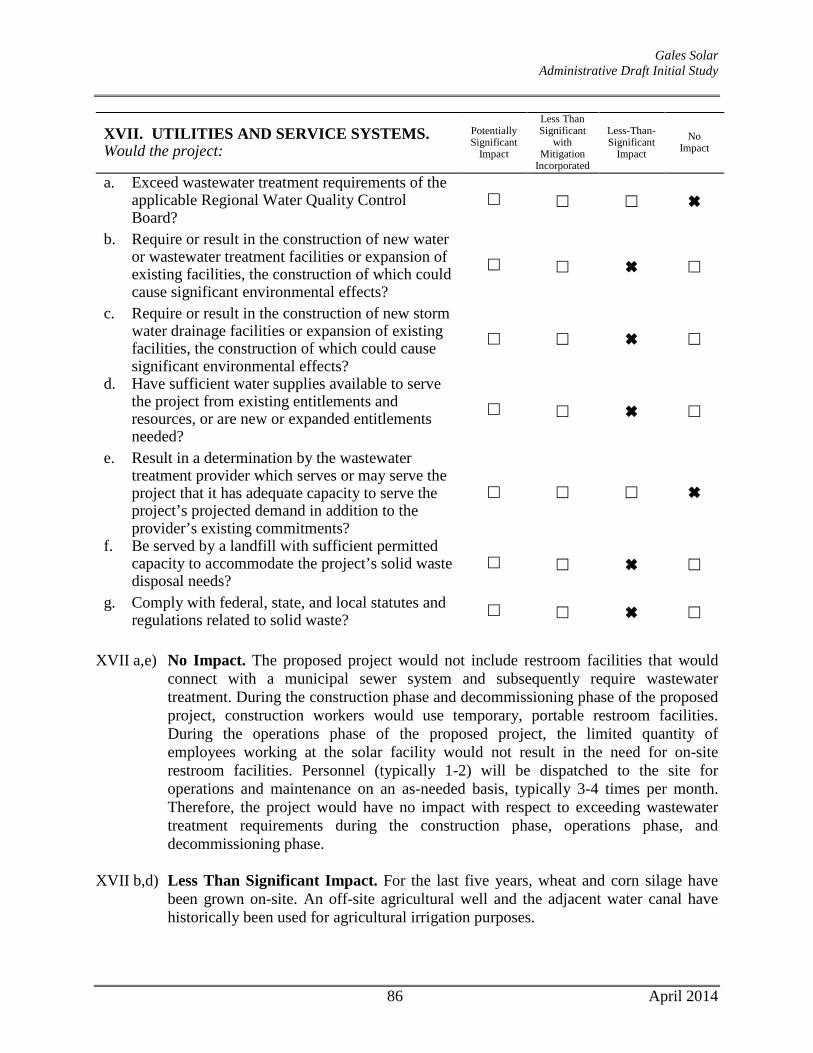
Gales Solar Administrative Draft Initial Study
XVII. UTILITIES AND SERVICE SYSTEMS. Would the project:
Potentially Significant
Impact
Less Than Significant
with Mitigation
Incorporated
Less-Than-Significant
Impact No
Impact
a. Exceed wastewater treatment requirements of the applicable Regional Water Quality Control Board?
b. Require or result in the construction of new water or wastewater treatment facilities or expansion of existing facilities, the construction of which could cause significant environmental effects?
c. Require or result in the construction of new storm water drainage facilities or expansion of existing facilities, the construction of which could cause significant environmental effects?
d. Have sufficient water supplies available to serve the project from existing entitlements and resources, or are new or expanded entitlements needed?
e. Result in a determination by the wastewater treatment provider which serves or may serve the project that it has adequate capacity to serve the project’s projected demand in addition to the provider’s existing commitments?
f. Be served by a landfill with sufficient permitted capacity to accommodate the project’s solid waste disposal needs?
g. Comply with federal, state, and local statutes and regulations related to solid waste?
XVII a,e) No Impact. The proposed project would not include restroom facilities that would
connect with a municipal sewer system and subsequently require wastewater treatment. During the construction phase and decommissioning phase of the proposed project, construction workers would use temporary, portable restroom facilities. During the operations phase of the proposed project, the limited quantity of employees working at the solar facility would not result in the need for on-site restroom facilities. Personnel (typically 1-2) will be dispatched to the site for operations and maintenance on an as-needed basis, typically 3-4 times per month. Therefore, the project would have no impact with respect to exceeding wastewater treatment requirements during the construction phase, operations phase, and decommissioning phase.
XVII b,d) Less Than Significant Impact. For the last five years, wheat and corn silage have
been grown on-site. An off-site agricultural well and the adjacent water canal have historically been used for agricultural irrigation purposes.
86 April 2014

Gales Solar Administrative Draft Initial Study
As explained above, the applicant would implement one of two options to reduce impacts related to the existing FSZ contract for the project site. The first option would involve cancellation of the existing FSZ contract and cessation of agricultural operations on the site during the lifetime of the project. Discontinuing on-site farming operations during the life of the project would actually benefit the groundwater aquifer by preserving groundwater that would otherwise be used for flood crop irrigation. The second option – if FSZ cancellation is unsuccessful – would consist of solar generation use in conjunction with modified, on-site agricultural operations utilizing much-less water intensive drip irrigation practices. Water would be provided by a new on-site agricultural well, and/or utilization of an existing off-site well, and/or the adjacent water canal. Table 11 provides historic on-site irrigation water use compared to the projected on-site water use for the project. Even under Option 2, on-site water use would be substantially less than historic use, with an anticipated reduction in water use by 19.5 ac.ft./yr as compared to historic use (33 – 13.5). This equates to a total decrease in water usage by approximately 6,354,095 gallons per year. While construction of the project is anticipated to require another 51,540 gallons (see Table 12), the project’s annual water usage would still be substantially less than historic annual on-site water use. It should be noted that the water needed for periodic panel washing, during on-going operation of the project, would be trucked in. Dryland farming of wheat, oats, barley, or grasses, would occur in rows and underneath solar panels to support sheep grazing. Dryland farming is a water-conserving method of farming that relies on precipitation rather than irrigation.
As a result, the project would have a less-than-significant impact with respect to having sufficient water supplies available to serve the project from existing entitlements and resources; and the construction of new water facilities or expansion of existing facilities would not be needed.
XVII c) Less Than Significant Impact. The proposed project would be located in a rural,
unincorporated area of Kings County. Existing stormwater drainage infrastructure is not currently found on the project site, and backbone infrastructure would not be required as part of the proposed project. The proposed project will discharge uncontaminated water, which is used to clean the solar panels, as well as stormwater runoff, onto the ground surface, after which the water will infiltrate or gradually migrate into the existing on-site drainage patterns. Currently, during storm events, stormwater sheet flows on the site towards the northeast, along existing drainage patterns. These drainage patterns would not be disrupted during development of the project given the limited grading that would occur.
The rate and amount of stormwater runoff would not appreciably increase as approximately 97 percent of the site will remain permeable upon project implementation. Minimal concrete would be required to install the PV mounting systems - vertical steel posts would be installed via a pneumatic ramming technique and set in concrete footings (2 feet in diameter x 3.5 feet in height). Spacing between each row of panels (post to post) will be approximately 10-14 feet. Internal access
87 April 2014

Gales Solar Administrative Draft Initial Study
driveways will be provided by placing and compacting a pervious, non-combustible material such as gravel or decomposed granite. Impermeable structures, including the foundations supporting the inverter pads, will cover less than half an acre of the 22-acre project site. In summary, the project would have a less-than-significant impact to drainage facilities because the project would not require or result in the construction of new storm water drainage facilities or expansion of existing facilities, the construction of which could cause significant environmental effects
XVII f,g) Less Than Significant Impact. The proposed project will be an unmanned solar
power generating facility, generating no process waste and only small quantities of solid waste that would require disposal. Waste from construction and operation of the project would be disposed of at municipal solid waste (MSW) Landfill B-17, located in Kettleman City, California. This landfill’s average annual throughput ranges from 100,000-249,999 tons/year and has an average annual capacity of 500,000-749,999 tons/year.23
Solid waste would be generated at the Gales Solar site primarily during construction and would consist of unused materials and by-products of construction activities. The project would not have adverse impacts on Landfill B-17 because the project would generate only a relatively small amount of construction waste that would easily be accommodated by the existing landfill. In addition, construction waste would be sorted at the Kings Waste and Recycling Authority (KWRA) Material Recovery Facility and Transfer Station prior to being disposed of at the landfill, and any recyclable materials would be taken out prior to the disposal of the remainder of the waste. In addition, some wooden construction waste (such as wood from wood pallets) would be sold, recycled, or chipped and spread on the project site for weed control as appropriate, and other compostable materials, such as vegetation, might also be composted off-site, further reducing the volume of solid waste that would be transported to the landfill. Project waste disposal would have a minimal impact on the capacity of MSW Landfill B-17 and would not require the development of new or expanded landfills, and a less-than-significant impact would result under this criterion.
23 http://www.calrecycle.ca.gov/FacIT/Facility/Operations.aspx?FacilityID=18240; accessed January 28, 2014.
88 April 2014

Gales Solar Administrative Draft Initial Study
XVIII. MANDATORY FINDINGS OF SIGNIFICANCE.
Potentially Significant
Impact
Less Than Significant
with Mitigation
Incorporated
Less-Than-Significant
Impact No
Impact
a. Does the project have the potential to degrade the quality of the environment, substantially reduce the habitat of a fish or wildlife species, cause a fish or wildlife population to drop below self-sustaining levels, threaten to eliminate a plant or animal community, reduce the number or restrict the range of a rare or endangered plant or animal or eliminate important examples of the major periods of California history or prehistory?
b. Does the project have impacts that are individually limited, but cumulatively considerable? ("Cumulatively considerable" means that the incremental effects of a project are considerable when viewed in connection with the effects of past projects, the effects of other current projects, and the effects of probable future projects)?
c. Does the project have environmental effects which will cause substantial adverse effects on human beings, either directly or indirectly?
XVIII a) Less than Significant Impact. Mitigation Measures have been included in this Initial
Study to address potential impacts to Biological Resources and Cultural Resources. With such measures, implementation of the proposed project would not degrade the quality of the environment, substantially reduce the habitat of fish or wildlife species, cause a fish or wildlife populations to drop below self-sustaining levels, threaten to eliminate a plant or animal community, or reduce the number or restrict the range of a rare or endangered plant or animal, or eliminate important examples of the major periods of California history or prehistory. This would be considered a less-than-significant impact.
XVIII b) Less Than Significant Impact. Cumulative impacts are defined as two or more
individual effects that, when considered together, are considerable or that compound or increase other environmental impacts. The cumulative impact from several projects is the change in the environment that results from the incremental impact of the development when added to the impacts of other closely related past, present, and reasonably foreseeable or probable future developments. Cumulative impacts can result from individually minor, but collectively significant, developments taking place over a period.
Other solar-generating facilities within Kings County have been conditionally
approved. Similar to the Gales Solar Project, each of these projects is required to implement mitigation measures to ensure that significant impacts are minimized.
89 April 2014
Gales Solar Administrative Draft Initial Study
The project will construct a green-energy-producing facility on a 22-acre vacant portion of the larger 28-acre parcel. This cleaner energy will replace that produced with fossil fuels. Based on this, the project will not have individually limited, but cumulatively considerable impacts. The facility will be unmanned throughout its operation. Trips generated by periodic maintenance workers will be minimal in comparison to the overall traffic in the area. Compliance with the conditions of approval issued for the proposed development will further assure that project-level impacts would not be cumulatively considerable.
XVIII c) Less Than Significant Impact. The project consists of the development of a solar
energy generating facility that will require minimal disturbance to the physical environment. Upon implementation of the project, minimal vehicle trips would be generated on an ongoing basis. The only vehicle trips necessary throughout the long-term operation of the proposed project would be associated with periodic on-site maintenance activities, which are anticipated to occur three to four times per month. In addition, the operation of on-site equipment would not require combustion of any fuels. Thus, the project would not be expected to result in any new environmental effects, such as significant increases in GHG emissions, risks related to geological hazards, exposure to hazards or hazardous materials, or exposure to excessive noise levels, that would cause adverse effects on human beings. Because adverse effects on human beings, either directly or indirectly, would not occur as a result of implementation of the proposed project, less-than-significant impacts would result.
90 April 2014
Gales Solar Administrative Draft Initial Study
REFERENCES Aspen Environmental Group. Biological Resources Technical Report, Gales Solar Project. April
22, 2013. Aspen Environmental Group. Cultural Resources Identification and Evaluation, Gales
Photovoltaic Solar Electric Generating Facility, Kings County, CA. March 2013. Babcock, K. W. 1995. Home Range and Habitat Use of Breeding Swainson’s Hawks in the
Sacramento Valley of California. Journal of Raptor Research 29:193–197. Bechard, M. J. 1982. Effect of Vegetative Cover on Foraging Site Selection by Swainson’s
Hawk. Condor 84:153–159 Bednarz, J.C., T. Hayden, and T. Fischer. 1990. The raptor and raven community of the Los
Medanos area in southeastern New Mexico: a unique and significant resource. N.Y. State Mus. Bull. 471: 92-101.
California Air Resources Board. Air Quality and Land Use Handbook: A Community Health Perspective. April 2005. California Department of Conservation, Farmland Mapping and Monitoring Program. Soil
Candidate Listing for Prime Farmland and Farmland of Statewide Importance, Kings County. September 1986.
CalRecycle. Facility Operations: Chemical Waste MGMT, Inc. Unit B-17.
http://www.calrecycle.ca.gov/FacIT/Facility/Operations.aspx?FacilityID=18240; accessed January 28, 2014.
Caltrans. Eligible (E) and Officially Designated (OD) Routes.
http://www.dot.ca.gov/hq/LandArch/scenic/cahisys.htm; accessed January 28, 2014. Dudek. Acoustical Assessment Report, Rugged Solar LLC Project. December 2013. ENVIRON International Corporation and the California Air Districts. California Emissions
Estimator Model User’s Guide Version 2013.2. July 2013. Estep, J.A. Biology, Movements, and Habitat Relationships of the Swainson’s Hawk in the
Central Valley of California, 1986–1987. California Department of Fish and Game, Nongame Bird and Mammal Section, Sacramento, CA. 1989.
Estep, J.A. The Distribution, Abundance, and Habitat Associations of the Swainson’s Hawk
(Buteo swainsoni) in South Sacramento County. Prepared by Estep Environmental Consulting for the City of Elk Grove, CA. 2006.
Estep, J.A. The Distribution, Abundance, and Habitat Associations of the Swainson’s Hawk
91 April 2014

Gales Solar Administrative Draft Initial Study
(Buteo swainsoni) in Yolo County, California. Prepared by Estep Environmental Consulting for Technology Associates International Corporation (San Diego, CA) and the Yolo Natural Heritage Program (Woodland, CA). 2008.
Estep, J.A. The Influence of Vegetation Structure on Swainson’s Hawk (Buteo swainsoni)
Foraging Habitat Suitability in Yolo County, California. Prepared by Estep Environmental Consulting for Technology Associates International Corporation (San Diego, CA) and the Yolo Natural Heritage Program (Woodland, CA). 2009
Estep, J.A. The Distribution and Abundance of Nesting Swainson’s Hawks in the Vicinity of the
Proposed RE Kansas South LLC Solar Generation Facility. Prepared by Estep Environmental Consulting for RE Kansas South LLC in San Francisco, CA. 2011
Federal Highway Administration. Visual Impact Assessment for Highway Projects. 1988. Holdrege & Kull. Geotechnical Engineering Report for Gales Photovoltaic Facility, 7th Avenue, Kings
County. April 9, 2013. Kings County. County of Kings 2035 General Plan Update EIR. June 2009. Kings County. Kings County Agricultural Preserves 2013, Williamson Act & Farmland Security
Zone Properties Map. October 8, 2013. Kings County. Kings County Airport Land Use Compatibility Plan. 1994. Kings County. 2035 Kings County General Plan. Adopted January 26, 2010. Kings County Sheriff’s Department. http://www.countyofkings.com/sheriff/substations.html;
accessed January 27, 2014. Kings County. Staff Report for Public Hearing – Determination on Commercial Solar
Compatibility with the Williamson Act. March 27, 2012. San Joaquin Valley Air Pollution Control District. Draft Guidance for Assessing and Mitigating
Air Quality Impacts – 2012. May 2012. San Joaquin Valley Air Pollution Control District. Guidance for Valley Land-use Agencies in
Addressing GHG Emission Impacts for New Projects under CEQA. December 17, 2009. Schmutz, J. K. The effect of agriculture on Ferruginous and Swainson’s hawks. Journal of Range
Management 40(5): 438-440. 1987. University of California Cooperative Extension. Sample Costs to Produce Strawberries, San
Joaquin Valley (2004). U.S. Environmental Protection Agency. Greenhouse Gas Equivalencies Calculator.
92 April 2014

Gales Solar Administrative Draft Initial Study
http://www.epa.gov/cleanenergy/energy-resources/calculator.html; accessed January 23, 2014.
U.S. Environmental Protection Agency. Green Power Equivalency Calculator. Available at:
http://www.epa.gov/greenpower/pubs/calculator.htm. Accessed January 2014. Woodbridge, B., K. K. Finley, and P. H. Bloom. Reproductive performance, age structure, and
natal dispersal of Swainson’s hawks in the Butte Valley, California. J. Raptor Res. 29:187-192.1995.
93 April 2014

Appendix A
Air Quality and Greenhouse Gas Modeling

San Joaquin Valley Unified APCD Air District, Annual
Gales Solar
1.1 Land Usage
Land Uses Size Metric Lot Acreage Floor Surface Area Population
Other Non-Asphalt Surfaces 20.00 Acre 20.00 871,200.00 0
1.2 Other Project Characteristics
Urbanization
Climate Zone
Rural
3
Wind Speed (m/s) Precipitation Freq (Days)2.7 45
1.3 User Entered Comments & Non-Default Data
1.0 Project Characteristics
Utility Company Southern California Edison
2014Operational Year
CO2 Intensity (lb/MWhr)
630.89 0.029CH4 Intensity (lb/MWhr)
0.006N2O Intensity (lb/MWhr)
CalEEMod Version: CalEEMod.2013.2.2 Date: 2/13/2014 10:58 AMPage 1 of 23

Project Characteristics -
Land Use - project is a 3MW solar generation facility - total site acreage = 20, but only disturbing 3.500 squre feet
Construction Phase - based on informaiton from applicant
Off-road Equipment - based on equipment anticipated to be used on-site per information from applicant (bore/drill rigs assumed for ramming machines; concrete and mortar mixers assumed for concrete buggies)
Off-road Equipment - based on equipment assumed for site per information from applicant
Off-road Equipment - based on equipment assumed to be used on-site per information from applicant; rollers assumed for compaction of backfill
Trips and VMT - total maximum of 35 workers estimated for project at peak (i.e., max of 70 worker trips per day); max of 24 delivery truck trips per day
Grading - only approximately 3,500 square feet would be disturbed for the project
Vehicle Trips - 120 total trips per year = 0.33 trips per day / 20 acres = 0.0165 trip rate
Consumer Products - no area sources
Area Coating - no area sources
Landscape Equipment - no area sources
Energy Mitigation -
CalEEMod Version: CalEEMod.2013.2.2 Date: 2/13/2014 10:58 AMPage 2 of 23

Table Name Column Name Default Value New Value
tblAreaCoating Area_EF_Nonresidential_Exterior 150 0
tblAreaCoating ReapplicationRatePercent 10 0
tblAreaMitigation UseLowVOCPaintNonresidentialExteriorValue
0 150
tblConstructionPhase NumDays 300.00 50.00
tblConstructionPhase NumDays 30.00 10.00
tblConstructionPhase PhaseStartDate 3/22/2014 3/23/2014
tblConstructionPhase PhaseStartDate 3/15/2014 3/17/2014
tblGrading AcresOfGrading 0.00 0.08
tblOffRoadEquipment HorsePower 205.00 226.00
tblOffRoadEquipment LoadFactor 0.50 0.29
tblOffRoadEquipment OffRoadEquipmentUnitAmount 1.00 0.00
tblOffRoadEquipment OffRoadEquipmentUnitAmount 3.00 0.00
tblOffRoadEquipment OffRoadEquipmentUnitAmount 1.00 0.00
tblOffRoadEquipment OffRoadEquipmentUnitAmount 1.00 0.00
tblOffRoadEquipment OffRoadEquipmentUnitAmount 1.00 0.00
tblOffRoadEquipment OffRoadEquipmentUnitAmount 2.00 0.00
tblOffRoadEquipment OffRoadEquipmentUnitAmount 3.00 2.00
tblOffRoadEquipment OffRoadEquipmentUnitAmount 1.00 0.00
tblProjectCharacteristics UrbanizationLevel Urban Rural
tblTripsAndVMT VendorTripNumber 143.00 24.00
tblTripsAndVMT WorkerTripNumber 366.00 70.00
tblVehicleTrips CW_TTP 0.00 100.00
tblVehicleTrips PR_TP 0.00 100.00
tblVehicleTrips ST_TR 0.00 0.02
tblVehicleTrips SU_TR 0.00 0.02
tblVehicleTrips WD_TR 0.00 0.02
CalEEMod Version: CalEEMod.2013.2.2 Date: 2/13/2014 10:58 AMPage 3 of 23

2.0 Emissions Summary
2.1 Overall Construction
ROG NOx CO SO2 Fugitive PM10
Exhaust PM10
PM10 Total
Fugitive PM2.5
Exhaust PM2.5
PM2.5 Total
Bio- CO2 NBio- CO2 Total CO2 CH4 N2O CO2e
Year tons/yr MT/yr
2014 0.0968 0.9792 0.7858 1.4300e-003
0.0264 0.0455 0.0718 7.0700e-003
0.0420 0.0490 0.0000 130.0984 130.0984 0.0290 0.0000 130.7080
Total 0.0968 0.9792 0.7858 1.4300e-003
0.0264 0.0455 0.0718 7.0700e-003
0.0420 0.0490 0.0000 130.0984 130.0984 0.0290 0.0000 130.7080
Unmitigated Construction
ROG NOx CO SO2 Fugitive PM10
Exhaust PM10
PM10 Total
Fugitive PM2.5
Exhaust PM2.5
PM2.5 Total
Bio- CO2 NBio- CO2 Total CO2 CH4 N2O CO2e
Year tons/yr MT/yr
2014 0.0968 0.9792 0.7858 1.4300e-003
0.0264 0.0455 0.0718 7.0700e-003
0.0420 0.0490 0.0000 130.0983 130.0983 0.0290 0.0000 130.7079
Total 0.0968 0.9792 0.7858 1.4300e-003
0.0264 0.0455 0.0718 7.0700e-003
0.0420 0.0490 0.0000 130.0983 130.0983 0.0290 0.0000 130.7079
Mitigated Construction
CalEEMod Version: CalEEMod.2013.2.2 Date: 2/13/2014 10:58 AMPage 4 of 23

2.2 Overall Operational
ROG NOx CO SO2 Fugitive PM10
Exhaust PM10
PM10 Total
Fugitive PM2.5
Exhaust PM2.5
PM2.5 Total
Bio- CO2 NBio- CO2 Total CO2 CH4 N2O CO2e
Category tons/yr MT/yr
Area 3.4025 0.0000 1.9000e-004
0.0000 0.0000 0.0000 0.0000 0.0000 0.0000 3.6000e-004
3.6000e-004
0.0000 0.0000 3.8000e-004
Energy 0.0000 0.0000 0.0000 0.0000 0.0000 0.0000 0.0000 0.0000 0.0000 0.0000 0.0000 0.0000 0.0000 0.0000
Mobile 5.2000e-004
2.6300e-003
6.6100e-003
1.0000e-005
6.7000e-004
4.0000e-005
7.1000e-004
1.8000e-004
4.0000e-005
2.2000e-004
0.0000 0.9937 0.9937 4.0000e-005
0.0000 0.9945
Waste 0.0000 0.0000 0.0000 0.0000 0.0000 0.0000 0.0000 0.0000 0.0000 0.0000
Water 0.0000 0.0000 0.0000 0.0000 0.0000 0.0000 0.0000 0.0000 0.0000 0.0000
Total 3.4030 2.6300e-003
6.8000e-003
1.0000e-005
6.7000e-004
4.0000e-005
7.1000e-004
1.8000e-004
4.0000e-005
2.2000e-004
0.0000 0.9941 0.9941 4.0000e-005
0.0000 0.9949
Unmitigated Operational
ROG NOx CO SO2 Fugitive PM10
Exhaust PM10
PM10 Total
Fugitive PM2.5
Exhaust PM2.5
PM2.5 Total
Bio- CO2 NBio-CO2 Total CO2 CH4 N20 CO2e
Percent Reduction
0.00 0.00 0.00 0.00 0.00 0.00 0.00 0.00 0.00 0.00 0.00 0.00 0.00 0.00 0.00 0.00
CalEEMod Version: CalEEMod.2013.2.2 Date: 2/13/2014 10:58 AMPage 5 of 23

2.2 Overall Operational
ROG NOx CO SO2 Fugitive PM10
Exhaust PM10
PM10 Total
Fugitive PM2.5
Exhaust PM2.5
PM2.5 Total
Bio- CO2 NBio- CO2 Total CO2 CH4 N2O CO2e
Category tons/yr MT/yr
Area 3.4025 0.0000 1.9000e-004
0.0000 0.0000 0.0000 0.0000 0.0000 0.0000 3.6000e-004
3.6000e-004
0.0000 0.0000 3.8000e-004
Energy 0.0000 0.0000 0.0000 0.0000 0.0000 0.0000 0.0000 0.0000 0.0000 0.0000 0.0000 0.0000 0.0000 0.0000
Mobile 5.2000e-004
2.6300e-003
6.6100e-003
1.0000e-005
6.7000e-004
4.0000e-005
7.1000e-004
1.8000e-004
4.0000e-005
2.2000e-004
0.0000 0.9937 0.9937 4.0000e-005
0.0000 0.9945
Waste 0.0000 0.0000 0.0000 0.0000 0.0000 0.0000 0.0000 0.0000 0.0000 0.0000
Water 0.0000 0.0000 0.0000 0.0000 0.0000 0.0000 0.0000 0.0000 0.0000 0.0000
Total 3.4030 2.6300e-003
6.8000e-003
1.0000e-005
6.7000e-004
4.0000e-005
7.1000e-004
1.8000e-004
4.0000e-005
2.2000e-004
0.0000 0.9941 0.9941 4.0000e-005
0.0000 0.9949
Mitigated Operational
3.0 Construction Detail
Construction Phase
Phase Number
Phase Name Phase Type Start Date End Date Num Days Week
Num Days Phase Description
1 Grading Grading 3/3/2014 3/14/2014 5 10
2 Trenching Trenching 3/17/2014 3/21/2014 5 5
3 Building Construction Building Construction 3/23/2014 5/30/2014 5 50
ROG NOx CO SO2 Fugitive PM10
Exhaust PM10
PM10 Total
Fugitive PM2.5
Exhaust PM2.5
PM2.5 Total
Bio- CO2 NBio-CO2 Total CO2 CH4 N20 CO2e
Percent Reduction
0.00 0.00 0.00 0.00 0.00 0.00 0.00 0.00 0.00 0.00 0.00 0.00 0.00 0.00 0.00 0.00
CalEEMod Version: CalEEMod.2013.2.2 Date: 2/13/2014 10:58 AMPage 6 of 23

OffRoad Equipment
Phase Name Offroad Equipment Type Amount Usage Hours Horse Power Load Factor
Grading Excavators 2 8.00 162 0.38
Grading Graders 0 8.00 174 0.41
Grading Rubber Tired Dozers 0 8.00 255 0.40
Grading Scrapers 0 8.00 361 0.48
Grading Tractors/Loaders/Backhoes 2 8.00 97 0.37
Trenching Excavators 2 8.00 162 0.38
Trenching Rollers 1 8.00 80 0.38
Trenching Tractors/Loaders/Backhoes 2 8.00 97 0.37
Building Construction Bore/Drill Rigs 3 8.00 226 0.29
Building Construction Cement and Mortar Mixers 4 8.00 9 0.56
Building Construction Cranes 0 7.00 226 0.29
Building Construction Excavators 2 8.00 162 0.38
Building Construction Forklifts 0 8.00 89 0.20
Building Construction Generator Sets 0 8.00 84 0.74
Building Construction Tractors/Loaders/Backhoes 2 7.00 97 0.37
Building Construction Welders 0 8.00 46 0.45
Trips and VMT
Residential Indoor: 0; Residential Outdoor: 0; Non-Residential Indoor: 0; Non-Residential Outdoor: 0 (Architectural Coating – sqft)
Acres of Grading (Site Preparation Phase): 0
Acres of Grading (Grading Phase): 0.08
Acres of Paving: 0
CalEEMod Version: CalEEMod.2013.2.2 Date: 2/13/2014 10:58 AMPage 7 of 23

3.2 Grading - 2014
ROG NOx CO SO2 Fugitive PM10
Exhaust PM10
PM10 Total
Fugitive PM2.5
Exhaust PM2.5
PM2.5 Total
Bio- CO2 NBio- CO2 Total CO2 CH4 N2O CO2e
Category tons/yr MT/yr
Fugitive Dust 4.0000e-005
0.0000 4.0000e-005
0.0000 0.0000 0.0000 0.0000 0.0000 0.0000 0.0000 0.0000 0.0000
Off-Road 7.9200e-003
0.0859 0.0585 8.0000e-005
5.2600e-003
5.2600e-003
4.8400e-003
4.8400e-003
0.0000 8.0947 8.0947 2.3900e-003
0.0000 8.1449
Total 7.9200e-003
0.0859 0.0585 8.0000e-005
4.0000e-005
5.2600e-003
5.3000e-003
0.0000 4.8400e-003
4.8400e-003
0.0000 8.0947 8.0947 2.3900e-003
0.0000 8.1449
Unmitigated Construction On-Site
3.1 Mitigation Measures Construction
Phase Name Offroad Equipment Count
Worker Trip Number
Vendor Trip Number
Hauling Trip Number
Worker Trip Length
Vendor Trip Length
Hauling Trip Length
Worker Vehicle Class
Vendor Vehicle Class
Hauling Vehicle Class
Grading 4 10.00 0.00 0.00 16.80 6.60 20.00 LD_Mix HDT_Mix HHDT
Trenching 5 13.00 0.00 0.00 16.80 6.60 20.00 LD_Mix HDT_Mix HHDT
Building Construction 11 70.00 24.00 0.00 16.80 6.60 20.00 LD_Mix HDT_Mix HHDT
CalEEMod Version: CalEEMod.2013.2.2 Date: 2/13/2014 10:58 AMPage 8 of 23

3.2 Grading - 2014
ROG NOx CO SO2 Fugitive PM10
Exhaust PM10
PM10 Total
Fugitive PM2.5
Exhaust PM2.5
PM2.5 Total
Bio- CO2 NBio- CO2 Total CO2 CH4 N2O CO2e
Category tons/yr MT/yr
Hauling 0.0000 0.0000 0.0000 0.0000 0.0000 0.0000 0.0000 0.0000 0.0000 0.0000 0.0000 0.0000 0.0000 0.0000 0.0000 0.0000
Vendor 0.0000 0.0000 0.0000 0.0000 0.0000 0.0000 0.0000 0.0000 0.0000 0.0000 0.0000 0.0000 0.0000 0.0000 0.0000 0.0000
Worker 2.9000e-004
4.6000e-004
4.4900e-003
1.0000e-005
6.2000e-004
1.0000e-005
6.3000e-004
1.7000e-004
0.0000 1.7000e-004
0.0000 0.5935 0.5935 4.0000e-005
0.0000 0.5943
Total 2.9000e-004
4.6000e-004
4.4900e-003
1.0000e-005
6.2000e-004
1.0000e-005
6.3000e-004
1.7000e-004
0.0000 1.7000e-004
0.0000 0.5935 0.5935 4.0000e-005
0.0000 0.5943
Unmitigated Construction Off-Site
ROG NOx CO SO2 Fugitive PM10
Exhaust PM10
PM10 Total
Fugitive PM2.5
Exhaust PM2.5
PM2.5 Total
Bio- CO2 NBio- CO2 Total CO2 CH4 N2O CO2e
Category tons/yr MT/yr
Fugitive Dust 4.0000e-005
0.0000 4.0000e-005
0.0000 0.0000 0.0000 0.0000 0.0000 0.0000 0.0000 0.0000 0.0000
Off-Road 7.9200e-003
0.0859 0.0585 8.0000e-005
5.2600e-003
5.2600e-003
4.8400e-003
4.8400e-003
0.0000 8.0947 8.0947 2.3900e-003
0.0000 8.1449
Total 7.9200e-003
0.0859 0.0585 8.0000e-005
4.0000e-005
5.2600e-003
5.3000e-003
0.0000 4.8400e-003
4.8400e-003
0.0000 8.0947 8.0947 2.3900e-003
0.0000 8.1449
Mitigated Construction On-Site
CalEEMod Version: CalEEMod.2013.2.2 Date: 2/13/2014 10:58 AMPage 9 of 23

3.2 Grading - 2014
ROG NOx CO SO2 Fugitive PM10
Exhaust PM10
PM10 Total
Fugitive PM2.5
Exhaust PM2.5
PM2.5 Total
Bio- CO2 NBio- CO2 Total CO2 CH4 N2O CO2e
Category tons/yr MT/yr
Hauling 0.0000 0.0000 0.0000 0.0000 0.0000 0.0000 0.0000 0.0000 0.0000 0.0000 0.0000 0.0000 0.0000 0.0000 0.0000 0.0000
Vendor 0.0000 0.0000 0.0000 0.0000 0.0000 0.0000 0.0000 0.0000 0.0000 0.0000 0.0000 0.0000 0.0000 0.0000 0.0000 0.0000
Worker 2.9000e-004
4.6000e-004
4.4900e-003
1.0000e-005
6.2000e-004
1.0000e-005
6.3000e-004
1.7000e-004
0.0000 1.7000e-004
0.0000 0.5935 0.5935 4.0000e-005
0.0000 0.5943
Total 2.9000e-004
4.6000e-004
4.4900e-003
1.0000e-005
6.2000e-004
1.0000e-005
6.3000e-004
1.7000e-004
0.0000 1.7000e-004
0.0000 0.5935 0.5935 4.0000e-005
0.0000 0.5943
Mitigated Construction Off-Site
3.3 Trenching - 2014
ROG NOx CO SO2 Fugitive PM10
Exhaust PM10
PM10 Total
Fugitive PM2.5
Exhaust PM2.5
PM2.5 Total
Bio- CO2 NBio- CO2 Total CO2 CH4 N2O CO2e
Category tons/yr MT/yr
Off-Road 4.8900e-003
0.0515 0.0343 5.0000e-005
3.2700e-003
3.2700e-003
3.0100e-003
3.0100e-003
0.0000 4.6782 4.6782 1.3800e-003
0.0000 4.7072
Total 4.8900e-003
0.0515 0.0343 5.0000e-005
3.2700e-003
3.2700e-003
3.0100e-003
3.0100e-003
0.0000 4.6782 4.6782 1.3800e-003
0.0000 4.7072
Unmitigated Construction On-Site
CalEEMod Version: CalEEMod.2013.2.2 Date: 2/13/2014 10:58 AMPage 10 of 23

3.3 Trenching - 2014
ROG NOx CO SO2 Fugitive PM10
Exhaust PM10
PM10 Total
Fugitive PM2.5
Exhaust PM2.5
PM2.5 Total
Bio- CO2 NBio- CO2 Total CO2 CH4 N2O CO2e
Category tons/yr MT/yr
Hauling 0.0000 0.0000 0.0000 0.0000 0.0000 0.0000 0.0000 0.0000 0.0000 0.0000 0.0000 0.0000 0.0000 0.0000 0.0000 0.0000
Vendor 0.0000 0.0000 0.0000 0.0000 0.0000 0.0000 0.0000 0.0000 0.0000 0.0000 0.0000 0.0000 0.0000 0.0000 0.0000 0.0000
Worker 1.9000e-004
3.0000e-004
2.9200e-003
0.0000 4.0000e-004
0.0000 4.1000e-004
1.1000e-004
0.0000 1.1000e-004
0.0000 0.3858 0.3858 2.0000e-005
0.0000 0.3863
Total 1.9000e-004
3.0000e-004
2.9200e-003
0.0000 4.0000e-004
0.0000 4.1000e-004
1.1000e-004
0.0000 1.1000e-004
0.0000 0.3858 0.3858 2.0000e-005
0.0000 0.3863
Unmitigated Construction Off-Site
ROG NOx CO SO2 Fugitive PM10
Exhaust PM10
PM10 Total
Fugitive PM2.5
Exhaust PM2.5
PM2.5 Total
Bio- CO2 NBio- CO2 Total CO2 CH4 N2O CO2e
Category tons/yr MT/yr
Off-Road 4.8900e-003
0.0515 0.0343 5.0000e-005
3.2700e-003
3.2700e-003
3.0100e-003
3.0100e-003
0.0000 4.6782 4.6782 1.3800e-003
0.0000 4.7072
Total 4.8900e-003
0.0515 0.0343 5.0000e-005
3.2700e-003
3.2700e-003
3.0100e-003
3.0100e-003
0.0000 4.6782 4.6782 1.3800e-003
0.0000 4.7072
Mitigated Construction On-Site
CalEEMod Version: CalEEMod.2013.2.2 Date: 2/13/2014 10:58 AMPage 11 of 23

3.3 Trenching - 2014
ROG NOx CO SO2 Fugitive PM10
Exhaust PM10
PM10 Total
Fugitive PM2.5
Exhaust PM2.5
PM2.5 Total
Bio- CO2 NBio- CO2 Total CO2 CH4 N2O CO2e
Category tons/yr MT/yr
Hauling 0.0000 0.0000 0.0000 0.0000 0.0000 0.0000 0.0000 0.0000 0.0000 0.0000 0.0000 0.0000 0.0000 0.0000 0.0000 0.0000
Vendor 0.0000 0.0000 0.0000 0.0000 0.0000 0.0000 0.0000 0.0000 0.0000 0.0000 0.0000 0.0000 0.0000 0.0000 0.0000 0.0000
Worker 1.9000e-004
3.0000e-004
2.9200e-003
0.0000 4.0000e-004
0.0000 4.1000e-004
1.1000e-004
0.0000 1.1000e-004
0.0000 0.3858 0.3858 2.0000e-005
0.0000 0.3863
Total 1.9000e-004
3.0000e-004
2.9200e-003
0.0000 4.0000e-004
0.0000 4.1000e-004
1.1000e-004
0.0000 1.1000e-004
0.0000 0.3858 0.3858 2.0000e-005
0.0000 0.3863
Mitigated Construction Off-Site
3.4 Building Construction - 2014
ROG NOx CO SO2 Fugitive PM10
Exhaust PM10
PM10 Total
Fugitive PM2.5
Exhaust PM2.5
PM2.5 Total
Bio- CO2 NBio- CO2 Total CO2 CH4 N2O CO2e
Category tons/yr MT/yr
Off-Road 0.0621 0.7502 0.4099 8.9000e-004
0.0352 0.0352 0.0325 0.0325 0.0000 83.4734 83.4734 0.0238 0.0000 83.9731
Total 0.0621 0.7502 0.4099 8.9000e-004
0.0352 0.0352 0.0325 0.0325 0.0000 83.4734 83.4734 0.0238 0.0000 83.9731
Unmitigated Construction On-Site
CalEEMod Version: CalEEMod.2013.2.2 Date: 2/13/2014 10:58 AMPage 12 of 23

3.4 Building Construction - 2014
ROG NOx CO SO2 Fugitive PM10
Exhaust PM10
PM10 Total
Fugitive PM2.5
Exhaust PM2.5
PM2.5 Total
Bio- CO2 NBio- CO2 Total CO2 CH4 N2O CO2e
Category tons/yr MT/yr
Hauling 0.0000 0.0000 0.0000 0.0000 0.0000 0.0000 0.0000 0.0000 0.0000 0.0000 0.0000 0.0000 0.0000 0.0000 0.0000 0.0000
Vendor 0.0112 0.0747 0.1184 1.3000e-004
3.5300e-003
1.5200e-003
5.0600e-003
1.0100e-003
1.4000e-003
2.4100e-003
0.0000 12.1005 12.1005 1.3000e-004
0.0000 12.1033
Worker 0.0102 0.0161 0.1572 2.6000e-004
0.0218 1.9000e-004
0.0219 5.7800e-003
1.7000e-004
5.9500e-003
0.0000 20.7724 20.7724 1.2600e-003
0.0000 20.7990
Total 0.0214 0.0908 0.2757 3.9000e-004
0.0253 1.7100e-003
0.0270 6.7900e-003
1.5700e-003
8.3600e-003
0.0000 32.8729 32.8729 1.3900e-003
0.0000 32.9023
Unmitigated Construction Off-Site
ROG NOx CO SO2 Fugitive PM10
Exhaust PM10
PM10 Total
Fugitive PM2.5
Exhaust PM2.5
PM2.5 Total
Bio- CO2 NBio- CO2 Total CO2 CH4 N2O CO2e
Category tons/yr MT/yr
Off-Road 0.0621 0.7502 0.4099 8.9000e-004
0.0352 0.0352 0.0325 0.0325 0.0000 83.4733 83.4733 0.0238 0.0000 83.9730
Total 0.0621 0.7502 0.4099 8.9000e-004
0.0352 0.0352 0.0325 0.0325 0.0000 83.4733 83.4733 0.0238 0.0000 83.9730
Mitigated Construction On-Site
CalEEMod Version: CalEEMod.2013.2.2 Date: 2/13/2014 10:58 AMPage 13 of 23

4.0 Operational Detail - Mobile
ROG NOx CO SO2 Fugitive PM10
Exhaust PM10
PM10 Total
Fugitive PM2.5
Exhaust PM2.5
PM2.5 Total
Bio- CO2 NBio- CO2 Total CO2 CH4 N2O CO2e
Category tons/yr MT/yr
Mitigated 5.2000e-004
2.6300e-003
6.6100e-003
1.0000e-005
6.7000e-004
4.0000e-005
7.1000e-004
1.8000e-004
4.0000e-005
2.2000e-004
0.0000 0.9937 0.9937 4.0000e-005
0.0000 0.9945
Unmitigated 5.2000e-004
2.6300e-003
6.6100e-003
1.0000e-005
6.7000e-004
4.0000e-005
7.1000e-004
1.8000e-004
4.0000e-005
2.2000e-004
0.0000 0.9937 0.9937 4.0000e-005
0.0000 0.9945
4.1 Mitigation Measures Mobile
3.4 Building Construction - 2014
ROG NOx CO SO2 Fugitive PM10
Exhaust PM10
PM10 Total
Fugitive PM2.5
Exhaust PM2.5
PM2.5 Total
Bio- CO2 NBio- CO2 Total CO2 CH4 N2O CO2e
Category tons/yr MT/yr
Hauling 0.0000 0.0000 0.0000 0.0000 0.0000 0.0000 0.0000 0.0000 0.0000 0.0000 0.0000 0.0000 0.0000 0.0000 0.0000 0.0000
Vendor 0.0112 0.0747 0.1184 1.3000e-004
3.5300e-003
1.5200e-003
5.0600e-003
1.0100e-003
1.4000e-003
2.4100e-003
0.0000 12.1005 12.1005 1.3000e-004
0.0000 12.1033
Worker 0.0102 0.0161 0.1572 2.6000e-004
0.0218 1.9000e-004
0.0219 5.7800e-003
1.7000e-004
5.9500e-003
0.0000 20.7724 20.7724 1.2600e-003
0.0000 20.7990
Total 0.0214 0.0908 0.2757 3.9000e-004
0.0253 1.7100e-003
0.0270 6.7900e-003
1.5700e-003
8.3600e-003
0.0000 32.8729 32.8729 1.3900e-003
0.0000 32.9023
Mitigated Construction Off-Site
CalEEMod Version: CalEEMod.2013.2.2 Date: 2/13/2014 10:58 AMPage 14 of 23

4.2 Trip Summary Information
4.3 Trip Type Information
Average Daily Trip Rate Unmitigated Mitigated
Land Use Weekday Saturday Sunday Annual VMT Annual VMT
Other Non-Asphalt Surfaces 0.33 0.33 0.33 1,766 1,766
Total 0.33 0.33 0.33 1,766 1,766
Miles Trip % Trip Purpose %
Land Use H-W or C-W H-S or C-C H-O or C-NW H-W or C-W H-S or C-C H-O or C-NW Primary Diverted Pass-by
Other Non-Asphalt Surfaces 14.70 6.60 6.60 100.00 0.00 0.00 100 0 0
5.0 Energy Detail
5.1 Mitigation Measures Energy
4.4 Fleet Mix
LDA LDT1 LDT2 MDV LHD1 LHD2 MHD HHD OBUS UBUS MCY SBUS MH
0.414654 0.062558 0.156261 0.179339 0.052131 0.008047 0.017854 0.095889 0.001821 0.001637 0.006500 0.000975 0.002335
Historical Energy Use: N
CalEEMod Version: CalEEMod.2013.2.2 Date: 2/13/2014 10:58 AMPage 15 of 23

ROG NOx CO SO2 Fugitive PM10
Exhaust PM10
PM10 Total
Fugitive PM2.5
Exhaust PM2.5
PM2.5 Total
Bio- CO2 NBio- CO2 Total CO2 CH4 N2O CO2e
Category tons/yr MT/yr
Electricity Mitigated
0.0000 0.0000 0.0000 0.0000 0.0000 0.0000 0.0000 0.0000 0.0000 0.0000
Electricity Unmitigated
0.0000 0.0000 0.0000 0.0000 0.0000 0.0000 0.0000 0.0000 0.0000 0.0000
NaturalGas Mitigated
0.0000 0.0000 0.0000 0.0000 0.0000 0.0000 0.0000 0.0000 0.0000 0.0000 0.0000 0.0000 0.0000 0.0000
NaturalGas Unmitigated
0.0000 0.0000 0.0000 0.0000 0.0000 0.0000 0.0000 0.0000 0.0000 0.0000 0.0000 0.0000 0.0000 0.0000
5.2 Energy by Land Use - NaturalGas
NaturalGas Use
ROG NOx CO SO2 Fugitive PM10
Exhaust PM10
PM10 Total
Fugitive PM2.5
Exhaust PM2.5
PM2.5 Total
Bio- CO2 NBio- CO2 Total CO2 CH4 N2O CO2e
Land Use kBTU/yr tons/yr MT/yr
Other Non-Asphalt Surfaces
0 0.0000 0.0000 0.0000 0.0000 0.0000 0.0000 0.0000 0.0000 0.0000 0.0000 0.0000 0.0000 0.0000 0.0000
Total 0.0000 0.0000 0.0000 0.0000 0.0000 0.0000 0.0000 0.0000 0.0000 0.0000 0.0000 0.0000 0.0000 0.0000
Unmitigated
CalEEMod Version: CalEEMod.2013.2.2 Date: 2/13/2014 10:58 AMPage 16 of 23

5.2 Energy by Land Use - NaturalGas
NaturalGas Use
ROG NOx CO SO2 Fugitive PM10
Exhaust PM10
PM10 Total
Fugitive PM2.5
Exhaust PM2.5
PM2.5 Total
Bio- CO2 NBio- CO2 Total CO2 CH4 N2O CO2e
Land Use kBTU/yr tons/yr MT/yr
Other Non-Asphalt Surfaces
0 0.0000 0.0000 0.0000 0.0000 0.0000 0.0000 0.0000 0.0000 0.0000 0.0000 0.0000 0.0000 0.0000 0.0000
Total 0.0000 0.0000 0.0000 0.0000 0.0000 0.0000 0.0000 0.0000 0.0000 0.0000 0.0000 0.0000 0.0000 0.0000
Mitigated
5.3 Energy by Land Use - Electricity
Electricity Use
Total CO2 CH4 N2O CO2e
Land Use kWh/yr MT/yr
Other Non-Asphalt Surfaces
0 0.0000 0.0000 0.0000 0.0000
Total 0.0000 0.0000 0.0000 0.0000
Unmitigated
CalEEMod Version: CalEEMod.2013.2.2 Date: 2/13/2014 10:58 AMPage 17 of 23

6.1 Mitigation Measures Area
6.0 Area Detail
ROG NOx CO SO2 Fugitive PM10
Exhaust PM10
PM10 Total
Fugitive PM2.5
Exhaust PM2.5
PM2.5 Total
Bio- CO2 NBio- CO2 Total CO2 CH4 N2O CO2e
Category tons/yr MT/yr
Mitigated 3.4025 0.0000 1.9000e-004
0.0000 0.0000 0.0000 0.0000 0.0000 0.0000 3.6000e-004
3.6000e-004
0.0000 0.0000 3.8000e-004
Unmitigated 3.4025 0.0000 1.9000e-004
0.0000 0.0000 0.0000 0.0000 0.0000 0.0000 3.6000e-004
3.6000e-004
0.0000 0.0000 3.8000e-004
5.3 Energy by Land Use - Electricity
Electricity Use
Total CO2 CH4 N2O CO2e
Land Use kWh/yr MT/yr
Other Non-Asphalt Surfaces
0 0.0000 0.0000 0.0000 0.0000
Total 0.0000 0.0000 0.0000 0.0000
Mitigated
CalEEMod Version: CalEEMod.2013.2.2 Date: 2/13/2014 10:58 AMPage 18 of 23

7.0 Water Detail
6.2 Area by SubCategory
ROG NOx CO SO2 Fugitive PM10
Exhaust PM10
PM10 Total
Fugitive PM2.5
Exhaust PM2.5
PM2.5 Total
Bio- CO2 NBio- CO2 Total CO2 CH4 N2O CO2e
SubCategory tons/yr MT/yr
Consumer Products
3.4025 0.0000 0.0000 0.0000 0.0000 0.0000 0.0000 0.0000 0.0000 0.0000 0.0000
Landscaping 2.0000e-005
0.0000 1.9000e-004
0.0000 0.0000 0.0000 0.0000 0.0000 0.0000 3.6000e-004
3.6000e-004
0.0000 0.0000 3.8000e-004
Architectural Coating
0.0000 0.0000 0.0000 0.0000 0.0000 0.0000 0.0000 0.0000 0.0000 0.0000 0.0000
Total 3.4025 0.0000 1.9000e-004
0.0000 0.0000 0.0000 0.0000 0.0000 0.0000 3.6000e-004
3.6000e-004
0.0000 0.0000 3.8000e-004
Unmitigated
ROG NOx CO SO2 Fugitive PM10
Exhaust PM10
PM10 Total
Fugitive PM2.5
Exhaust PM2.5
PM2.5 Total
Bio- CO2 NBio- CO2 Total CO2 CH4 N2O CO2e
SubCategory tons/yr MT/yr
Consumer Products
3.4025 0.0000 0.0000 0.0000 0.0000 0.0000 0.0000 0.0000 0.0000 0.0000 0.0000
Landscaping 2.0000e-005
0.0000 1.9000e-004
0.0000 0.0000 0.0000 0.0000 0.0000 0.0000 3.6000e-004
3.6000e-004
0.0000 0.0000 3.8000e-004
Architectural Coating
0.0000 0.0000 0.0000 0.0000 0.0000 0.0000 0.0000 0.0000 0.0000 0.0000 0.0000
Total 3.4025 0.0000 1.9000e-004
0.0000 0.0000 0.0000 0.0000 0.0000 0.0000 3.6000e-004
3.6000e-004
0.0000 0.0000 3.8000e-004
Mitigated
CalEEMod Version: CalEEMod.2013.2.2 Date: 2/13/2014 10:58 AMPage 19 of 23

7.1 Mitigation Measures Water
Total CO2 CH4 N2O CO2e
Category MT/yr
Mitigated 0.0000 0.0000 0.0000 0.0000
Unmitigated 0.0000 0.0000 0.0000 0.0000
7.2 Water by Land Use
Indoor/Outdoor Use
Total CO2 CH4 N2O CO2e
Land Use Mgal MT/yr
Other Non-Asphalt Surfaces
0 / 0 0.0000 0.0000 0.0000 0.0000
Total 0.0000 0.0000 0.0000 0.0000
Unmitigated
CalEEMod Version: CalEEMod.2013.2.2 Date: 2/13/2014 10:58 AMPage 20 of 23

8.1 Mitigation Measures Waste
7.2 Water by Land Use
Indoor/Outdoor Use
Total CO2 CH4 N2O CO2e
Land Use Mgal MT/yr
Other Non-Asphalt Surfaces
0 / 0 0.0000 0.0000 0.0000 0.0000
Total 0.0000 0.0000 0.0000 0.0000
Mitigated
8.0 Waste Detail
Total CO2 CH4 N2O CO2e
MT/yr
Mitigated 0.0000 0.0000 0.0000 0.0000
Unmitigated 0.0000 0.0000 0.0000 0.0000
Category/Year
CalEEMod Version: CalEEMod.2013.2.2 Date: 2/13/2014 10:58 AMPage 21 of 23

8.2 Waste by Land Use
Waste Disposed
Total CO2 CH4 N2O CO2e
Land Use tons MT/yr
Other Non-Asphalt Surfaces
0 0.0000 0.0000 0.0000 0.0000
Total 0.0000 0.0000 0.0000 0.0000
Unmitigated
Waste Disposed
Total CO2 CH4 N2O CO2e
Land Use tons MT/yr
Other Non-Asphalt Surfaces
0 0.0000 0.0000 0.0000 0.0000
Total 0.0000 0.0000 0.0000 0.0000
Mitigated
9.0 Operational Offroad
Equipment Type Number Hours/Day Days/Year Horse Power Load Factor Fuel Type
CalEEMod Version: CalEEMod.2013.2.2 Date: 2/13/2014 10:58 AMPage 22 of 23

10.0 Vegetation
CalEEMod Version: CalEEMod.2013.2.2 Date: 2/13/2014 10:58 AMPage 23 of 23

Green Power Partnership
Publications & Resources
Partnership Documents
Tools & Calculators
Green Power Incentives
Glossary
Related Links
Communications Support
Green Power Partner Mark
Green Power Equivalency CalculatorUPDATED November 2012. Several of the equivalency conversion factors have been updated with newer or revised values.See the revision history page for more details.
This calculator can help you in better communicating a green power purchase to interested stakeholders by translating it fromkilowatt-hours (kWh) purchased into more understandable terms, such as an equivalent number of passenger vehicles, homes, or coalplants. This calculator uses EPA’s eGRID utility nonbaseload emissions rates and should not be used to determine the emissionsassociated with your conventional electricity use.
Step 1: Identify the Region where Your Green Power (Purchase) was Generated
To best estimate the environmental equivalency of your green power purchase, you will need to know the geographical location andrespective contribution in kWh of each renewable generation facility (e.g., wind farm, on-site solar project etc.) associated with your greenpower purchase. If you do not know the location or respective kWh contribution of each renewable generation facility, advance to Option 2under Step 2 below.
Note: EPA’s Power Profiler tool can aid you in identifying the correct subregion for facilities that fall near subregion boundaries. To use Power Profiler, you will need to have the renewable facility’s zip code and the utilityname to which the generation facility is grid connected. Power Profiler identifies the correct eGRID sub region above the green table after you have selected the zip code and utility.
Step 2: Input Data & Calculate Results
This calculator offers two choices for entering green power data:
Option 1: Match each renewable generation facility to a subregion using the map above; input the kWh contribution of each generator under the correct subregion (use thenumber or four-letter code) in the table below and click the calculate button. The total kWh across all subregions should equal the total amount of your green power purchase. Ifyou do not know the location or respective kWh contribution for each renewable generation facility, advance to Option 2 below.
1NWPP
2MROW
3MROE
4RFCM
5RFCE
6NYUP
7NEWE
8NYLI
9NYCW
10SRVC
11SRTV
12RFCW
13SRMW
14SPNO
15RMPA
16CAMX
17AZNM
18SPSO
19SRMV
20SRSO
21ERCT
22 23 24 25 26
http://www.epa.gov/greenpower/pubs/calculator.htm
Green Power Equivalency Calculator | Green Power Partnership | US EPA http://www.epa.gov/greenpower/pubs/calculator.htm
1 of 2 1/28/2014 2:47 PM

Last updated on Tuesday, November 13, 2012
FRCC AKMS AKGD HIOA HIMS
Option 2: Although not as accurate, you can still estimate your avoided CO2 emissions by using the total kWh of your green power purchase. The calculator will use a U.S.non-baseload CO2 emissions rate. Input the total kWh of your green power purchase below and click the calculate button.
Total kWh Purchased
(National AverageEmissions Rate)
Note: Due the variability between individual sub region emissions rates and the national average emissions rate, estimated equivalency statements may vary between Input Option 1 and 2 above. For best results, askyour green power provider for the location and kWh contribution of each renewable generation facility(s) for your purchase.
Step 3: Estimated Results & Equivalency Statements
Read about all calculations and methodologies - ?
Your green power purchase will avoid an estimated of carbon dioxide emissions, which is the equivalent to one of the following:
the greenhouse gas emissions from passenger vehicles each year. ?
the CO2 emissions from gallons of gasoline consumed. ?
the CO2 emissions from barrels of oil consumed. ?
the CO2 emissions from propane cylinders used for home barbeques. ?
the CO2 emissions from burning railcars’ worth of coal. ?
the annual CO2 emissions of coal fired power plants ?
the CO2 emissions from the electricity use of average American homes for one year. ?
Organizations should review the making environmental claims section of this web site before making claims associated with a green power purchase.
If you have Javascript disabled in your Web browser, please refer to the following Web page for the calculations, methodologies and references used in the online calculator. Forfurther questions about this calculator, please contact Blaine Collison ([email protected], 202-343-9139).
The above calculator is based on the Greenhouse Gas Equivalencies Calculator found on EPA’s Clean Energy Web site. The Green Power Equivalency Calculator has beencustomized to accommodate data input requirements for green power purchases and on-site renewable energy systems.
Green Power Equivalency Calculator | Green Power Partnership | US EPA http://www.epa.gov/greenpower/pubs/calculator.htm
2 of 2 1/28/2014 2:47 PM

Appendix B
Construction Noise Model Results

Roadway Construction Noise Model (RCNM),Version 1.1
Report date: 4/17/2014Case Description: Gales Solar
‐‐‐‐ Receptor #1 ‐‐‐‐Baselines (dBA)
Description Land Use Daytime Evening NightSingle Family Home Residential 53 53 45
EquipmentSpec Actual Receptor Estimated
Impact Lmax Lmax Distance ShieldingDescription Device Usage(%) (dBA) (dBA) (feet) (dBA)Vibratory Pile Driver No 20 100.8 130 0Backhoe No 40 77.6 90 0Concrete Mixer Truck No 40 78.8 90 0Dump Truck No 40 76.5 90 0Roller No 20 80 90 0Scraper No 40 83.6 90 0
ResultsCalculated (dBA) Noise Limits (dBA) Noise Limit Exceedance (dBA)
Day Evening Night Day Evening NightEquipment *Lmax Leq Lmax Leq Lmax Leq Lmax Leq Lmax Leq Lmax Leq Lmax LeqVibratory Pile Driver 92.5 85.5 75 55 N/A N/A N/A N/A 17.5 30.5 N/A N/A N/A N/ABackhoe 72.5 68.5 75 55 N/A N/A N/A N/A None 13.5 N/A N/A N/A N/AConcrete Mixer Truck 73.7 69.7 75 55 N/A N/A N/A N/A None 14.7 N/A N/A N/A N/ADump Truck 71.3 67.4 75 55 N/A N/A N/A N/A None 12.4 N/A N/A N/A N/ARoller 74.9 67.9 75 55 N/A N/A N/A N/A None 12.9 N/A N/A N/A N/AScraper 78.5 74.5 75 55 N/A N/A N/A N/A 3.5 19.5 N/A N/A N/A N/A
Total 92.5 86.2 75 55 N/A N/A N/A N/A 17.5 31.2 N/A N/A N/A N/A*Calculated Lmax is the Loudest value.
‐‐‐‐ Receptor #2 ‐‐‐‐Baselines (dBA)
Description Land Use Daytime Evening NightSingle Family Home Residential 53 53 45
EquipmentSpec Actual Receptor Estimated
Impact Lmax Lmax Distance ShieldingDescription Device Usage(%) (dBA) (dBA) (feet) (dBA)Vibratory Pile Driver No 20 100.8 165 0Backhoe No 40 77.6 150 0Concrete Mixer Truck No 40 78.8 150 0Dump Truck No 40 76.5 150 0

Roller No 20 80 150 0Scraper No 40 83.6 150 0
ResultsCalculated (dBA) Noise Limits (dBA) Noise Limit Exceedance (dBA)
Day Evening Night Day Evening NightEquipment *Lmax Leq Lmax Leq Lmax Leq Lmax Leq Lmax Leq Lmax Leq Lmax LeqVibratory Pile Driver 90.4 83.5 75 55 N/A N/A N/A N/A 15.4 28.5 N/A N/A N/A N/ABackhoe 68 64 75 55 N/A N/A N/A N/A None 9 N/A N/A N/A N/AConcrete Mixer Truck 69.3 65.3 75 55 N/A N/A N/A N/A None 10.3 N/A N/A N/A N/ADump Truck 66.9 62.9 75 55 N/A N/A N/A N/A None 7.9 N/A N/A N/A N/ARoller 70.5 63.5 75 55 N/A N/A N/A N/A None 8.5 N/A N/A N/A N/AScraper 74 70.1 75 55 N/A N/A N/A N/A None 15.1 N/A N/A N/A N/A
Total 90.4 83.8 75 55 N/A N/A N/A N/A 15.4 28.8 N/A N/A N/A N/A*Calculated Lmax is the Loudest value.

Appendix C
Biological Resources Report

BIOLOGICAL RESOURCES TECHNICAL REPORT Gales Solar Project
Prepared for:
A Better Electric... Belectric 8076 Central Avenue Newark, CA 94560
Prepared by:
Aspen Environmental Group 201 North First Ave., No. 102 Upland, CA 91786
April 22, 2013

1
Nick Pappani
From: Beth Hoffman <[email protected]>Sent: Friday, April 18, 2014 3:51 PMTo: Nick PappaniSubject: FW: Belectric Gales Project - Swainson's hawk mitigation
From: Scott White [mailto:[email protected]] Sent: Friday, April 18, 2014 3:39 PM To: Beth Hoffman Cc: [email protected] Subject: Belectric Gales Project - Swainson's hawk mitigation Beth, Aspen Environmental Group prepared the Biological Resources Technical Report (BRTR) for the Gales Solar Project (dated April 22, 2013). That report recommended field surveys for nesting Swainson’s hawks and habitat compensation to offset project‐related foraging habitat loss. More recently, I have reviewed the draft Initial Study and Mitigated Negative Declaration (IS/MND, dated April 2014; tracked changes dated April 14, 15, and 17 2014) for the Gales Solar Project, and the Estep Environmental Consulting analysis of Swainson’s hawk foraging habitat, conducted for the KE Kansas South solar project. J.A. Estep is a recognized authority on Swainson’s hawk biology. The Estep analysis indicates that foraging habitat availability is not a limiting factor for Swainson’s hawks within the 10‐mile radius study area addressed for the KE Kansas South solar project. The conclusion is based on numbers of Swainson’s hawks in the area and on suitability and productivity of foraging habitat throughout the study area. Further, the Estep report concludes that loss of Swainson’s hawk foraging habitat would not be significant according to the California Environmental Quality Act (CEQA) guidelines. I understand that Kings County has adopted this approach to evaluating potential impacts to Swainson’s hawk foraging habitat, and has made findings that foraging habitat loss from this and other projects does not meet criteria as a significant impact as defined by the CEQA guidelines. The Gales project site is not within the KE Kansas South study area, but landscape and land uses are generally similar. The Draft IS/MND includes an analysis of the 10‐mile radius area surrounding the Gales project site, using the analytical methods of the Estep report. Based on this analysis , I concur with the Draft IS/MND, that the Gales Project’s impacts to Swainson’s hawk foraging habitat would not be significant according to the CEQA guidelines. Based on the conclusions by Estep Environmental Consulting and the IS/MND , Aspen concurs that habitat compensation recommended in the 2013 BRTR would not be necessary. Please contact me at your convenience if you have questions. ‐SW
Scott D. White, MA Senior Biologist www.aspeneg.com
201 North First Ave., No. 102Upland, CA 91786
Office: 909‐949‐3686 Cell: 909‐234‐8360
CONFIDENTIALITY STATEMENT: This electronic message contains information from Aspen Environmental Group and isconfidential or privileged. The information is intended solely for the use of the individual(s) or entity(ies) named above. If you are not the intended recipient, be aware that any disclosure, copying, distribution, or use of the contents of this message isprohibited. If you have received this e‐mail in error, please notify us immediately by telephone at (818) 597‐3407 or by e‐mail reply and then immediately delete this message. Thank you.

BIOLOGICAL RESOURCES TECHNICAL REPORT GALES SOLAR PROJECT
April 22, 2013 i Aspen Environmental Group
BIOLOGICAL RESOURCES TECHNICAL REPORT: Gales Solar Project
April 22, 2013
Contents I. Executive Summary ...................................................................................................................... 1 II. Project and Property Description ................................................................................................. 1 III. Focused Study / Species of Concern ............................................................................................ 2 IV. Methods .................................................................................................................................... 2 V. General Biological Survey Results ................................................................................................ 6 A. Vegetation and Habitat ................................................................................................................... 6 B. Wildlife ............................................................................................................................................ 6 VI. Special-status Species Results ..................................................................................................... 6 A. Special-status Plants ....................................................................................................................... 6 B. Special-status Wildlife ................................................................................................................... 7 VII. Impacts and Recommendations ................................................................................................. 8 A. Impacts to Special-status Wildlife ................................................................................................... 8 B. Impacts to Native Birds, Including Migratory Birds ........................................................................ 9 C. Impacts to Jurisdictional Hydrological Features ...........................................................................10 VIII. Recommended Agency Consultation or Further Studies .......................................................... 10 IX. Mitigation and Monitoring Recommendations ........................................................................ 10 A. Mitigation Recommendations ......................................................................................................10 B. Mitigation Monitoring Recommendations ...................................................................................12 X. Literature Cited ......................................................................................................................... 12
TABLES Table 1: Special-status species not addressed ............................................................................................ 3 Table 2: Special-status species with potential to occur in the project site ................................................ 4
ATTACHMENTS Attachment 1: Figures Figure 1: Project vicinity map Figure 2: Biological resources map Figure 3: Swainson’s hawk and San Joaquin kit fox occurrences Attachment 2: Project photos Attachment 3: Project species list Attachment 4: CNDDB query results

BIOLOGICAL RESOURCES TECHNICAL REPORT GALES SOLAR PROJECT
April 22, 2013 1 Aspen Environmental Group
BIOLOGICAL RESOURCES TECHNICAL REPORT:
Gales Solar Project Justin M. Wood and Scott D. White ASPEN ENVIRONMENTAL GROUP
April 22, 2013
I. Executive Summary
This report was prepared under contract to Belectric to support project review according to the California Environmental Quality Act (CEQA). This report describes biological resources at the proposed Gales Solar Project site in Kings County, California, evaluates potential impacts to those resources, and recommends mitigation to reduce those impacts below the level of significance. We describe biological resources and assess potential occurrence of special-status plants and animals based on a field survey conducted during January 2013.
Two state or federally listed threatened or endangered species occur in the project vicinity: San Joaquin kit fox and Swainson’s hawk. We found no sign of San Joaquin kit fox (state listed threatened and federally listed endangered) on the site, but it is likely that kit foxes forage on the site or travel across it. We recommend pre-construction surveys to ensure that no San Joaquin kit foxes are present on the site at the initiation of construction. We conducted Stage One of a Swainson’s hawk (state listed threatened) focused survey to identify potential nest locations. There were no nests or potential nest trees on the site. We did not observe nests within a 0.5 mile radius, but we identified several suitable nesting trees within 0.5 mile of the project site. We recommend completing a focused nesting season survey to determine if nesting Swainson’s hawks are present on the site or in the vicinity, and to identify the appropriate habitat compensation ratio. Based primarily on lack of suitable habitat, we conclude that no other listed threatened or endangered species would be found on the site.
Several special-status animals not listed as threatened or endangered could use the site, at least seasonally; adverse impacts to these species generally would not meet CEQA significance thresholds. We recommend pre-construction surveys for burrowing owls. If burrowing owls are present on the site, then we recommend either passive exclusion (outside the nesting season) or avoidance of any active burrow and a surrounding buffer area (during the nesting season). If initial site clearing takes place during nesting season for native birds, we recommend pre-construction surveys for nests and, if nests are present, avoidance of a buffer area surrounding each nest throughout the breeding season or until each nest becomes inactive.
There are no mapped streambeds within the site, and we observed no features within the site that are likely to meet the state and federal criteria as jurisdictional waters. We do not recommend a delineation of state and federal waters, and we conclude that no agency notification is necessary under the federal Clean Water Act or California Fish and Game Code Section 1602.
II. Project and Property Description
Belectric proposes to construct a 3.0 megawatt (MW) photovoltaic solar power plant on a 20-acre site in unincorporated Kings County. The project site is on private land, just northeast of the town of Hanford,

BIOLOGICAL RESOURCES TECHNICAL REPORT GALES SOLAR PROJECT
April 22, 2013 2 Aspen Environmental Group
California. It is located immediately east of Seventh Avenue, 2.3 miles north of State Route 198, and approximately 4 miles northeast of the city of Hanford (Figure 1; all figures are included in Attachment 1). The project site appears on the USGS Remnoy 7.5-minute topographic map in Township 18 South, Range 22 East, in the southwest quarter of Section 15 (Figure 1).
The project site is in active agricultural production. Topography is nearly flat and the elevation is about 260 feet. There are no drainages, irrigation ditches, irrigation canals, or berms within the project site, and no blueline features are shown on the USGS 7.5-minute map. Melga Canal is an irrigation canal just east of the project site that is mapped as a blue line feature on the USGS 7.5-minute topographic map. There is a paved road (Seventh Avenue) along the western edge of the project site. The other three sides of the site are bounded by unnamed dirt roads.
Project development would require clearing the entire 20-acre site for placement of solar panel support structures. The property would be surrounded by a seven foot tall chain link fence. Construction and maintenance equipment access would likely be via Seventh Avenue at the western boundary. The solar project would tie into an existing power line within the project site near the western boundary.
III. Focused Study / Species of Concern
This report (1) describes biological resources on the site, (2) evaluates habitat suitability for special-status species, (3) evaluates potential project impacts to those resources, and (4) recommends measures to mitigate potential impacts below the level of significance.
IV. Methods
Justin M. Wood and Tracy Valentovich of Aspen Environmental Group reviewed available literature to identify special-status plants, wildlife, or plant communities known from the project vicinity. We reviewed the California Natural Diversity Database (CDFW 2013) for USGS 7.5-minute Burris Park, Goshen, Guernsey, Hanford, Laton, Paige, Remnoy, Traver, and Waukena quads (Attachment 4). We also reviewed the California Native Plant Society (CNPS) On-line Electronic Inventory (CNPS 2013) for the quads listed above, and searched the Consortium of California Herbaria (2013) for records of special-status plants known from the area. Several special-status species, including all special-status plants known from the region, occur only in specialized native habitats (e.g., alkali and clay soils) that are absent from the project site. These plants and animals are listed in Table 1, but are not addressed further in this report. Table 2 lists all special-status animals known from comparable habitats within the region and summarizes their habitat, distribution, conservation status, and probability of occurrence on the site.
Wood and Valentovich visited the project site on January 17, 2013 and walked all access roads within and surrounding the site. We used binoculars to survey the site from roadsides, and drove all accessible roads within 0.5 mile of the property to locate potential nest sites for Swainson’s hawk (Buteo swainsoni), as described in the Swainson’s hawk survey guidelines (SWHATAC 2000). During the survey we noted habitat conditions and evaluated habitat suitability for special-status plants and animals. All plant and animal species observed were recorded in field notes. Plants, wildlife, and wildlife sign (e.g., scat, tracks, and burrows) were identified in the field using binoculars and field guides. All plant species observed were identified in the field or collected for later identification. Plants were identified using keys, descriptions, and illustrations in Baldwin et al. (2012) and other regional references. All species noted on or around the site are listed in the attached species list (Attachment 3).

BIOLOGICAL RESOURCES TECHNICAL REPORT GALES SOLAR PROJECT
April 22, 2013 3 Aspen Environmental Group
We did not delineate state or federally jurisdictional streambeds, but we did not observe any hydrologic features on the site that would meet state and federal criteria as jurisdictional waters.
Table 1. Special-status species not addressed due to habitat or geographic range.
Latin Name Common Name Reason for Exclusion
PLANTS
Atriplex cordulata var. cordulata Heartscale No suitable alkali or saline soils; incompatible land use.
Atriplex cordulata var. erecticaulis Earlimart orache No suitable grassland habitat; incompatible land use.
Atriplex depressa Brittlescale No suitable alkali or clay soils; incompatible land use.
Atriplex minuscula Lesser saltscale No suitable alkali or saline soils; incompatible land use.
Atriplex subtilis
Subtle orache No suitable vernal pool habitat; incompatible land use.
Delphinium recurvatum Recurved larkspur No suitable alkali or clay soils; incompatible land use.
Nama stenocarpum Mud nama No suitable wetland habitat; incompatible land use.
INVERTEBRATES
Branchinecta lynchi Vernal pool fairy shrimp No suitable vernal pool or aquatic habitat.
Cicindela tranquebarica ssp. San Joaquin tiger beetle No suitable alkali soils/habitat; incompatible land use.
Desmocerus californicus dimorphus Valley elderberry longhorn beetle Host plant, elderberry (Sambucus), not present.
Lepidurus packardi Vernal pool tadpole shrimp No suitable vernal pool or aquatic habitat.
AMPHIBIANS
Ambystoma californiense California tiger salamander No suitable breeding pools on site or in project vicinity; incompatible land use.
Spea hammondii Western spadefoot No suitable aquatic breeding habitats or upland habitats; incompatible land use.
REPTILES
Emys marmorata Western pond turtle No suitable aquatic habitat on the site or in vicinity.
Gambelia sila Blunt-nosed leopard lizard No suitable habitat; incompatible land use.
Thamnophis gigas Giant garter snake No suitable aquatic habitat on the site or in vicinity.
MAMMALS
Dipodomys nitratoides exilis Fresno kangaroo rat No suitable alkali shrubland or grassland habitat.
Dipodomys nitratoides nitratoides Tipton kangaroo rat No suitable grassland or shrubland habitat.

BIOLOGICAL RESOURCES TECHNICAL REPORT GALES SOLAR PROJECT
April 22, 2013 4 Aspen Environmental Group
Table 2. Special-status species with potential to occur in the project area
Species Name Habitat Requirements Activity Season
Conservation Status Potential to Occur
BIRDS
Agelaius tricolor Tricolored blackbird
Breeds colonially in freshwater marshes and grain fields; nomadic among marshes and fields in winter; almost completely endemic to Calif.
Year-around Fed: none CA: SC S2 (nesting)
Low: Potentially suitable nesting habitat on site and in the vicinity.
Athene cunicularia Burrowing owl
Nests in rodent burrows, usually in grasslands; forages in open habitat; in-creasingly uncommon in S Calif.; through W US and Mexico
Year-around Fed ESA: none CA: SC, S2
Moderate: suitable foraging and nesting habitat present, no sign observed during surveys.
Buteo swainsoni
Swainson’s hawk
Breeds in trees in open habitats (e.g., grassland), Central Valley and W Mojave Des (Calif.) and east to cent. US, S. Canada, New Mexico; winters in S America
Spring –
summer
Fed ESA: none
CA: S2, THR
High (foraging): known nest sites within 5 miles of the project, no suitable nesting habitat on site.
Lanius ludovicianus
Loggerhead shrike
Woodlands, shrublands, open areas with scattered perch sites; preys on insects and small vertebrates; wide-spread but declining in much of N America; valley floors to about 7000 ft. elev.
Year-around Fed ESA: none
CA: SC, S4
(nesting)
High (foraging):
suitable foraging
habitat throughout.
No nesting potential.
MAMMALS
Corynorhinus (Plecotus) townsendii Townsend's big-eared bat (incl. “pale,” “western,” and other subspecies)
Many habitats throughout Calif and W N Amer, scattered pop'ns in E; day roosts in caves, tunnels, mines; feed primarily on moths
Year-around Fed ESA: none CA: SC, S2S3
Moderate (foraging), minimal (roosting): suitable foraging habitat present on site.
Eumops perotis Western mastiff bat
Lowlands (rare exceptions); cent. and S Calif., S Ariz., NM, SW Tex., N Mexico; roost in deep rock crevices, forage over wide area
Year-around Fed ESA: none CA: SC, S3?
Moderate (foraging), minimal (roosting): suitable foraging habitat present on site.
Lasionycteris noctivigans Silver-haired bat
Much of North America, except warm and arid regions; migratory; winter range expands to south; forests, esp. near water; hibernates in trees, buildings, crevices
Winter; possibly also breeding
Fed ESA: none CA: SC, S2S3
Moderate (foraging), minimal (roosting): suitable foraging habitat present on site.
Lasiurus cinereus Hoary bat
Common and widespread, found in a wide range of habitats, roosts in dense foliage of medium to large trees and forages in open areas or habitat edges
Year-around, hibernates in winter in cold climates
Fed ESA: none CA: S4?
Moderate (foraging), minimal (roosting): suitable foraging habitat present on site.
Vulpes macrotis mutica San Joaquin kit fox
Open grasslands and shrublands; endemic to San Joaquin Valley
Year- around Fed ESA: END CA: S2S3, THR
High (foraging), minimal (denning): Suitable foraging habitat exists in project area.

BIOLOGICAL RESOURCES TECHNICAL REPORT GALES SOLAR PROJECT
April 22, 2013 5 Aspen Environmental Group
General references (botany): Baldwin et al. 2012; Calif. Dept. of Fish & Wildlife 2013, Calif. Native Plant Society 2013; Consortium of California Herbaria 2013. General references (wildlife): American Ornithologists Union 1998 (including supplements through 2011); Barbour and Davis 1969; Feldhammer et al. 2003; Grinnell and Miller 1944; Hall 1981; Jennings and Hayes 1994; Shuford and Gardal 2008; Stebbins 2003; Wilson and Ruff 1999. Conservation Status Federal designations: (federal ESA, USFWS). END: Federally listed, endangered. THR: Federally listed, threatened. Candidate: Sufficient data are available to support federal listing, but not yet listed. Proposed: Formally proposed for federal status shown. State designations: (CESA, CDFW) END: State listed, endangered. THR: State listed, threatened. RARE: State listed as rare (applied only to certain plants). SC: California species of special concern. Considered vulnerable to extinction due to declining numbers, limited geographic
ranges, or ongoing threats. FP: Fully protected. May not be taken or possessed without permit from CDFW. CDFW Natural Diversity Data Base Designations: Applied to special-status plants and sensitive plant communities; where correct category is uncertain, CDFW uses two categories or question marks. S1: Fewer than 6 occurrences or fewer than 1000 individuals or less than 2000 acres. S1.1: Very threatened S1.2: Threatened S1.3: No current threats known S2: 6-20 occurrences or 1000-3000 individuals or 2000-10,000 acres (decimal suffixes same as above). S3: 21-100 occurrences or 3000-10,000 individuals or 10,000-50,000 acres (decimal suffixes same as above). S4: Apparently secure in California; this rank is clearly lower than S3 but factors exist to cause some concern, i.e., there is
some threat or somewhat narrow habitat. No threat rank. S5: Demonstrably secure or ineradicable in California. No threat rank. SH: All California occurrences historical (i.e., no records in > 20 years). SX: Presumed extirpated in California. California Native Plant Society (CNPS) Rare Plant Rank designations. Note: According to CNPS (http://www.cnps.org/cnps/rareplants/ranking.php), plants ranked as CRPR 1A, 1B, and 2 meet definitions as threatened or endangered and are eligible for state listing. That interpretation of the state Endangered Species Act is not in general use. 1A: Plants presumed extinct in California. 1B: Plants rare and endangered in California and throughout their range. 2: Plants rare, threatened or endangered in California but more common elsewhere in their range. 3: Plants about which we need more information; a review list. 4: Plants of limited distribution; a watch list. California Rare Plant Rank Threat designations: .1 Seriously endangered in California (over 80% of occurrences threatened / high degree and immediacy of threat) .2 Fairly endangered in California (20-80% occurrences threatened) .3 Not very endangered in California (<20% of occurrences threatened or no current threats known) Definitions of occurrence probability: Estimated occurrence probabilities based literature sources cited earlier and field surveys and habitat analyses reported here. Present: Observed on the site by qualified biologists. Expected: Not observed or recorded on the site, but very likely present during at least a portion of the year. High: Habitat is a type often utilized by the species and the site is within the known range of the species. Moderate: Site is within the known range of the species and habitat on the site is a type occasionally used. Low: Site is within the species’ known range but habitat is rarely used, or the species was not found during focused surveys
covering less than 100% of potential habitat or completed in marginal seasons.

BIOLOGICAL RESOURCES TECHNICAL REPORT GALES SOLAR PROJECT
April 22, 2013 6 Aspen Environmental Group
Minimal: No suitable habitat on the site; or well outside the species’ known elevational or geographic ranges; or a focused study covering 100% of all suitable habitat, completed during the appropriate season and during a year of appropriate rainfall, did not detect the species.
Unknown: No focused surveys have been performed in the region, and the species’ distribution and habitat are poorly known.
V. General Biological Survey Results
V. A. Vegetation and Habitat
The project site is in active agricultural production. At the time of our field visit, the site was planted with a grain crop (Figure 2). No native plants were observed on the site. Several non-native annual plants were observed growing at the margins of the agricultural field. There are no structures on the site, but there is a residential building to the northwest. The irrigation canal to the east of the project site was dry, with very steep incised banks. The canal had no hydrologic connectivity to the project site.
No native vegetation as described by Sawyer et al. (2009) or Holland (1986) is present on the site. The agricultural fields have no special-status designation with the California Department of Fish and Wildlife (CDFW, formerly California Department of Fish and Game; CDFG 2001).
V. B. Wildlife
Very little wildlife or wildlife sign was observed during the field surveys. Wildlife observations included a red-tailed hawk (Buteo jamaicensis), an American kestrel (Falco sparverius), a morning dove (Zenaida macroura), and several house finches (Carpodacus mexicanus). Other common wildlife species that use agricultural lands throughout the region would also be likely to occur on the property. Attachment 3 lists all species observed or detected on the site.
VI. Special-status Species Results
Plants or wildlife may be ranked as special-status species due to declining populations, vulnerability to habitat change, or restricted distributions. Certain species have been listed as threatened or endangered under state or federal Endangered Species Acts (ESA). Others have not been listed, but declining populations or habitat availability cause concern for their long-term viability. These appear on lists compiled by resource agencies or private conservation organizations. In this report, “special-status species” is used to include all plants and animals listed as threatened or endangered or included in other compilations. All special-status plants and animals from similar habitats within the region are addressed in Table 1 or Table 2, with brief descriptions of habitat and distribution, conservation status, and probability of occurrence on the site.
VI. A. Special-status Plants
No listed threatened or endangered plants have been reported from the nine USGS 7.5-minute quads surrounding the project site (CDFW 2013; Table 1). Seven special-status plant species have been documented within these nine USGS 7.5-minute quads, but none of them have the potential to be present on the site due to lack of suitable habitat (Table 1). We conclude that no listed threatened or endangered plants and no other special-status plants are present on the site. Due to the date of our field survey (winter 2013, outside the flowering seasons for most plants), this conclusion is based on habitat suitability rather than on the field survey results.
BIOLOGICAL RESOURCES TECHNICAL REPORT GALES SOLAR PROJECT
April 22, 2013 7 Aspen Environmental Group
VI. B. Special-status Wildlife
Fourteen special-status wildlife species are reported within the nine USGS 7.5-minute quads surrounding the project site (CDFW 2013; Tables 1 and 2). Based on the habitat on or near the site and the closest known records, we conclude that two listed threatened or endangered wildlife species could occur on the project site: San Joaquin kit fox (Vulpes macrotis mutica) and Swainson’s hawk (Buteo swainsoni). Seven additional special-status wildlife species could also be present. Each of these species is addressed below and in Table 2.
Listed Threatened or Endangered Species
Swainson’s hawk Swainson’s hawk is state listed as threatened. During the breeding season, it is found throughout the general area. Swainson’s hawks nest in native valley oak (Quercus lobata) and other trees, including native and non-native species, such as ornamental trees and windrows near developments, roads, and agricultural lands (Estep 2008). Swainson’s hawks feed primarily on meadow voles (Microtus californicus) but also on a variety of other small mammals, small birds, reptiles, and insects (Estep 1989, 2008). They forage wherever food is available, especially in croplands, and can travel up to 14 miles from their nests to forage (Babcock 1995). Swainson’s hawks are likely to forage on the project site.
Several nesting sites have been documented within 5 miles of the project site; the nearest one is located 3.3 miles southeast of the site (Figure 3; CDFW 2013). There are no trees on the project site that may be suitable as a Swainson’s hawk nest site, but we observed several trees within the surrounding area that may be suitable for nesting. Some of these trees were valley oaks and others were unidentified ornamental trees. All of these trees were leafless (due to season), and any nests present would have been visible. We did not observe large stick nests characteristic of Swainson’s hawks in any of these trees.
San Joaquin kit fox San Joaquin kit fox is state listed as threatened and federally listed as endangered. It once occurred throughout the general region but the population has decreased significantly due to loss of habitat for agriculture and development. Kit fox home ranges average 1,000 acres and can be as large as 3,000 acres. They den in burrows that they excavate, typically by expanding old ground squirrel burrows. San Joaquin kit foxes feed on rabbits and squirrels, but kangaroo rats are the most important food source, comprising 80 to 90 percent of the diet (Laughrin 1970; USFWS 2010). They forage in open habitats, including agricultural fields.
The US Fish and Service (USFWS) has not designated critical habitat for San Joaquin kit fox. The project site is not within areas identified as “core,” “linkage,” or “satellite” areas for San Joaquin kit fox recovery (USFWS 1998; 2010). There are numerous historical San Joaquin kit fox records within 10 miles of the site, the nearest of which is approximately 2.7 miles to the east (Figure 3). No known dens have been reported from the project site (CDFW 2013), and we did not observe dens or potential dens during our field survey. Although kit foxes are unlikely to reside on the project site, they may occasionally forage on the site or cross it en route to other habitat. Due to ongoing agricultural practices, they are unlikely to den on the site, though denning kit foxes could move onto the site if disking or other activities were halted.

BIOLOGICAL RESOURCES TECHNICAL REPORT GALES SOLAR PROJECT
April 22, 2013 8 Aspen Environmental Group
Other Special-status Species
Burrowing owl Burrowing owls nest in burrows, typically those of ground squirrels, often on berms adjacent to irrigation canals and agricultural fields. They forage in open areas, including agricultural fields, disturbed lands, grasslands, and other open habitats. Several burrowing owl nests have been documented within 10 miles of the site (CDFW 2013). During reconnaissance-level surveys, no active burrows, sign, or potential burrow sites were located. The entire site is suitable as burrowing owl foraging habitat. Due to ongoing agricultural practices, they are unlikely to nest on the site, though burrowing owls could move onto the site if disking or other activities were halted.
Loggerhead shrike Loggerhead shrikes forage in agricultural fields and other open areas, and may nest in isolated shrubs and trees near agricultural fields (Ehrlich et al. 1988). Suitable foraging habitat is present throughout the project site, but no suitable nesting trees were present.
Tricolored blackbird Historically, tricolored blackbirds nested near freshwater marshes and built their nests in cattails or reeds. But more recently they have been documented in other habitats, such as grain fields, probably due to decline of available marsh habitat (Hamilton et al. 1995; Meese 2006; Shuford and Gardali 2008). Tricolored blackbirds could nest in the agricultural fields when grain crops are present, and they are likely to forage on the project site year-around.
Special-status bats Several special-status bats (Townsend's big-eared bat, western mastiff bat, silver-haired bat, and hoary bat) could forage over the project site. No suitable roosting sites (e.g., structures or trees) habitat were observed within the project site.
VII. Impacts and Recommendations
VII. A. Impacts to Special Status Wildlife
Swainson’s hawk The proposed project would eliminate 20 acres of Swainson’s hawk foraging habitat (within 5 miles of a known nest site), but would not eliminate any potential nest sites. Foraging habitat loss would be significant under CEQA, and we recommend habitat compensation consistent with CDFW guidelines to mitigate this impact (CDFG 1994). If project construction takes place during nesting season, and if Swainson’s hawks nest near the project site during construction, then project activities could disturb nesting Swainson’s hawks. Any take of Swainson’s hawk (e.g., by causing nest abandonment) would necessitate consultation with CDFW and USFWS under state and federal ESAs. We recommend avoiding potential take by (1) conducting pre-construction nesting season surveys within 0.5 miles of the project site, and avoiding initiation of new intensive disturbances within 0.5 miles of an active nest during the nesting season. Implementing these recommendations would mitigate the project’s potential impacts to Swainson’s hawk to a level less than significant.
San Joaquin kit fox The proposed project would eliminate 20 acres of agricultural lands, which may serve as San Joaquin kit fox foraging habitat. No kit fox dens were found on the site during field surveys. In addition, San Joaquin

BIOLOGICAL RESOURCES TECHNICAL REPORT GALES SOLAR PROJECT
April 22, 2013 9 Aspen Environmental Group
kit foxes would not be expected to den on the site due ongoing disturbance for agricultural land use. The project could impact kit fox movement patterns throughout the area by fencing potential movement routes. However, the site is surrounded by unobstructed movement habitat and is not located within a linkage area between important habitat areas or resources. Any take of San Joaquin kit fox would be significant under CEQA and necessitate consultation with CDFW and USFWS under state and federal ESAs. Take can be avoided by implementing the recommended mitigation measures below. The loss of agricultural foraging habitat would not be significant according to CEQA. However, recommended compensation for Swainson’s hawk foraging habitat would also serve to mitigate the loss of kit fox foraging habitat. Due to availability of movement routes throughout the project vicinity, we conclude that project impacts to San Joaquin kit fox movement routes would be less than significant under CEQA.
Burrowing owl Burrowing owls or active burrows were not observed on the site. But burrowing owls could occupy the site in the future, particularly if agricultural practices are halted. The project could affect burrowing owls and their habitat, but mitigation measures recommended below would avoid take of burrowing owls or their nests. In addition, compensation recommended for Swainson’s hawk foraging habitat would also compensate for burrowing owl habitat loss, reducing potential impacts to below the level of significance.
Loggerhead shrike The project could affect loggerhead shrike foraging habitat, but would not affect nesting sites. The loss of foraging habitat would not be a significant impact.
Tricolored blackbird Tricolored blackbirds could nest in grain fields on the project site. Mitigation measures recommended below would avoid take of active nests. In addition, compensation recommended for Swainson’s hawk foraging habitat would compensate for tricolored blackbird habitat loss, and reduce any potential impacts to below the level of significance.
Special-status bats The project would not affect special-status bat roosts, and any impacts to foraging habitat would be less than significant.
VII. B. Impacts to Native Birds, Including Migratory Birds
The federal Migratory Bird Treaty Act (MBTA) and California Fish and Game Code Sections 3503, 3503.5, and 3513 prohibit take of migratory birds, including eggs or active nests, except as permitted by regulation (e.g., licensed hunting). “Migratory bird” is broadly defined to apply to most native bird species, with the exception of a few non-native birds such as European starling. Most migratory bird species have no other special conservation status.
Most adult birds would normally avoid construction activities by flying away. But, depending on schedule, clearing for the proposed project could destroy nests and eggs if birds were nesting on the site during these activities. If present, adult burrowing owls would be likely to retreat into burrows rather than fly off the site, even outside the nesting season. The mitigation recommendations include measures to avoid impacts to burrowing owls and nesting birds.

BIOLOGICAL RESOURCES TECHNICAL REPORT GALES SOLAR PROJECT
April 22, 2013 10 Aspen Environmental Group
VII. C. Impacts to Jurisdictional Hydrologic Features
The project would not affect state or federal jurisdictional waters.
VIII. Recommended Agency Consultation or Further Studies
Aspen makes the following recommendations for follow-up surveys and agency consultation:
1. We conclude that the project has a minimal potential to take that listed threatened or endangered species (Swainson’s hawk or San Joaquin kit fox). However, if a San Joaquin kit fox den is found on the site or a Swainson’s hawk nest is found in the immediate project vicinity during preconstruction surveys, or during construction or operation of the facility, then any take, including disturbance or harassment, may violate state and federal ESAs. While no take is anticipated, the applicant may wish to apply to CDFW, USFWS, or both agencies for take authorization to avoid potential project delays in the unlikely event that either animal is found on the site or in the immediate vicinity.
2. We recommend that Belectric contract with a qualified biologist to conduct field surveys for nesting Swainson’s hawks according to the Recommended Timing and Methodology for Swainson’s Hawk Nesting Surveys in California’s Central Valley (SWHATAC 2000) within a 0.5 mile radius of the project site. The survey should be completed during a nesting season prior to the start of project construction. The results of the field survey will determine the applicable compensation ratio for Swainson’s hawk foraging habitat and any need for construction scheduling to avoid disturbing nesting activity (see Mitigation and Monitoring Recommendations).
IX. Mitigation and Monitoring Recommendations
IX. A. Mitigation Recommendations
Swainson’s hawk The project would not cause take of a Swainson’s hawk nest, but would eliminate 20 acres of suitable foraging habitat within 5 miles of a known nest site, and could affect Swainson’s hawk nesting activity, if construction is initiated within nesting season within 0.5 miles of an active nest. We make the following recommendations to reduce impacts below a level of significance, and avoid any potential for take of Swainson’s hawk:
1. We recommend compensating for loss of Swainson’s hawk foraging habitat at either 0.75:1 to 1:1, depending on distance from a known active nest. These ratios are based on CDFW mitigation guidelines (CDFG 1994). Mitigation lands should be located within a ten-mile radius of the affected nest and should be equally suitable as foraging habitat unless otherwise determined by the County. Kings County has implemented these ratios, and has required selection of lands designated Priority Agricultural or zoned as Exclusive Agriculture for compensation. If no new Swainson’s hawk nests are found during focused surveys (above), we recommend a mitigation ratio of 0.75:1 (acres protected: acres impacted), consistent with the CDFW Staff Report (CDFG 1994) for sites within 5 miles of a known nest. If recommend surveys determine that an active nest is located within 0.5 miles of the site, then we recommend a mitigation ratio of 1:1, consistent with ratios recommended by CDFW.
2. We recommend initiating intensive new construction-related disturbance within 0.5 miles of an active Swainson’s hawk nest during the nesting season. The nesting season is defined as March 1

BIOLOGICAL RESOURCES TECHNICAL REPORT GALES SOLAR PROJECT
April 22, 2013 11 Aspen Environmental Group
through September 15 (CDFG 1994). Therefore, if an active nest site is located within 0.5 miles of the project site, intensive disturbance may only be initiated after September 15 or before March 1. “Intensive disturbance” would include activities that increase noise, lighting, or visible human and equipment activities above existing levels on the site or in the surrounding area. Examples include larger sized or larger numbers of tractors and similar equipment, or driving solar panel support structures into the soil. Disturbance consistent with present and surrounding land use practices (such as agricultural equipment) would not be “intensive” in the context of this recommendation.
San Joaquin kit fox Based on habitat, surrounding land use, and our survey results, we conclude that San Joaquin kit foxes are not likely to den on the site. Still, there is a small possibility that kit foxes could construct and occupy a den on the site prior to the start of construction. Unauthorized take of a San Joaquin kit fox or an active den is prohibited under state and federal Endangered Species Acts. San Joaquin kit foxes may not be handled except under authorization by CDFW and USFWS. We therefore make the following recommendations to avoid any potential for take of San Joaquin kit fox:
1. A qualified biologist will survey the site prior to initial site disturbance to verify that no San Joaquin kit foxes or active dens are present.
2. An exclusion fence will be constructed around the project area perimeter to prevent San Joaquin kit foxes from entering the site during construction. The fence will be maintained throughout the construction phase of the project to ensure that kit foxes do not burrow underneath it.
3. If a San Joaquin kit fox is found within the project area during construction, then any project activities that could affect it will halt, pending consultation with CDFW and USFWS.
4. Upon completion of construction, at the direction of the County, a permanent security fence may be designed to allow passage of San Joaquin kit foxes through the project site. A design that raises the fencing 5 to 7 inches above the ground would improve kit fox movement opportunity through the area, but could put kit foxes at risk of injury or death during project operations and maintenance activities.
Burrowing owl We make the following recommendations to avoid incidental take of burrowing owl:
1. A qualified biologist will survey the site in advance of initial clearing to determine burrowing owl presence or absence. This survey may be done concurrently with the San Joaquin kit fox survey.
2. If one or more burrowing owls are present on the site outside of the nesting season (i.e., September 1 to January 31), then the qualified biologist may exclude them from the site using passive exclusion methods described in the CDFW staff report on burrowing owl mitigation (CDFG 2012).
3. If burrowing owls are present on the site during nesting season (i.e., February 1 through August 31), then construction will be either be postponed until the young fledge from the nest or the nest is no longer active, or no disturbance will be allowed within an appropriate buffer area to be established by a qualified biologist in accordance with the CDFW staff report on burrowing owl mitigation (CDFG 2012).
Nesting birds (other than burrowing owl) To avoid incidental take of native birds or destruction of nests or eggs, we recommend either of the
BIOLOGICAL RESOURCES TECHNICAL REPORT GALES SOLAR PROJECT
April 22, 2013 12 Aspen Environmental Group
following two measures:
1. Initial site clearing will be completed outside the breeding season (i.e., potential nesting habitat will not be disturbed between February 15 and August 15), or
2. Prior to beginning initial site clearing, but after survey flagging is in place marking the limits of grading, a qualified biologist will confirm that no birds are nesting in or adjacent to areas to be disturbed. If native birds are nesting on the site, then construction will be postponed until nesting is completed, or the nest is no longer active, or the qualified biologist will establish appropriate avoidance buffers around nests to protect nesting birds. No project-related disturbance will be allowed within these buffers.
IX. B. Mitigation Monitoring Recommendations
California law requires monitoring of mitigation measures imposed under CEQA. If the mitigation measures recommended above are adopted by the County, we recommend incorporating these measures into a Mitigation Monitoring and Compliance Plan to specify applicant and County requirements to (1) verify compliance with conditions of approval, (2) determine whether mitigation measures meet their intent, and (3) identify any need for corrective measures.
X. Literature Cited
American Ornithologists’ Union. 1998. Checklist of North American birds, seventh edition, and supple-ments. American Ornithologists’ Union, Washington, D.C.
Babcock, K. W. 1995. Home Range and Habitat Use of Breeding Swainson’s Hawks in the Sacramento Valley of California. Journal of Raptor Research 29:193–197.
Baldwin, B.G., D.H., Goldman, D.J. Keil, R. Patterson, and T.J. Rosatti (eds.). 2012. The Jepson Manual: Higher Plants of California. 2nd edition. University of California Press, Berkeley, California.
Barbour, R.W. and W.H. Davis. 1969. Bats of America. University Press of Kentucky, Lexington, Kentucky.
CDFG (California Department of Fish and Game). 1994. Staff report regarding mitigation for impacts to Swainson’s hawks (Buteo swainsoni) in the Central Valley of California. CDFG, Sacramento.
______. 2001. List of California terrestrial natural communities recognized by the Natural Diversity Database. CDFW Natural Diversity Database, Sacramento.
______. 2012. Staff Report on Burrowing Owl Mitigation. http://www.dfg.ca.gov/wildlife/nongame/docs/BUOWStaffReport.pdf
CDFW (California Department of Fish and Wildlife). 2013. RareFind (records of special-status species on the USGS Burris Park, Goshen, Guernsey, Hanford, Laton, Paige, Remnoy, Traver, and Waukena 7.5-minute topographic quads). Natural Heritage Division, CDFW, Sacramento.
CNPS (California Native Plant Society). 2013. Online Electronic Inventory (records of special-status species on the USGS Burris Park, Goshen, Guernsey, Hanford, Laton, Paige, Remnoy, Traver, and Waukena 7.5-minute topographic quads). CNPS, Sacramento.
Consortium of California Herbaria. 2013. http://ucjeps.berkeley.edu/consortium/
Ehrlich, P.R., D.S. Dobkin, and D. Wheye. 1988. Birder’s Handbook: A Field Guide to the Natural History of North American Birds. Fireside / Simon & Schuster Inc., New York, New York.

BIOLOGICAL RESOURCES TECHNICAL REPORT GALES SOLAR PROJECT
April 22, 2013 13 Aspen Environmental Group
Estep, J.A., 1989. Biology, Movements, and Habitat Relationships of the Swainson’s Hawk in the Central Valley of California, 1986–1987. California Department of Fish and Game, Nongame Bird and Mammal Section, Sacramento, CA.
______. 2008. The Distribution, Abundance, and Habitat Associations of the Swainson’s Hawk (Buteo swainsoni) in Yolo County, California. Report prepared for Technology Associates International Corporation and the Yolo Natural Heritage Program.
Feldhamer, G.A., B.C. Thompson, and J.A. Chapman (eds.). 2003. Wild Mammals of North America: Biology, Management and Conservation, 2nd ed. Johns Hopkins University Press, Baltimore MD.
Grinnell, J. and A.H. Miller. 1944. The distribution of the birds of California. Cooper Ornithological Club, Berkeley, California (reprint 1986 by Artemisia Press, Lee Vining, Calif.).
Hall, E.R. 1981. The Mammals of North America. John Wiley and Sons, New York.
Hamilton, W.J. III, L. Cook, and R. Grey. 1995. Tricolored blackbird project 1994. Unpublished report for U.S. Fish and Wildlife Service, Portland, Oregon.
Holland, R.F. 1986. Preliminary descriptions of the terrestrial natural communities of California. Unpublished. CDFW, Sacramento.
Jennings, M.R. and M.P. Hayes. 1994. Amphibian and reptile species of special concern in California. California Dept. of Fish and Game, Sacramento.
Laughrin, L. 1970. San Joaquin kit fox: its distribution and abundance. California Dept. Fish and Game. Sacramento, Wildlife Management Branch, Admin. Rep. No. 70-2, 20 pp.
Meese, R.J. 2006. Settlement and Breeding Colony Characteristic of Tricolored Blackbirds in 2006 in the Central Valley of California. Final report to U.S. Fish and Wildlife Service, Sacramento, California.
Sawyer, J.O., T. Keeler-Wolf, and J.M. Evens. 2009. A Manual of California Vegetation, Second Edition. California Native Plant Society, Sacramento. 1300 pp.
Shuford, W. D., and Gardali, T., editors. 2008. California Bird Species of Special Concern: A ranked assessment of species, subspecies, and distinct populations of birds of immediate conservation concern in California. Studies of Western Birds 1. Western Field Ornithologists, Camarillo, California, and California Department of Fish and Game, Sacramento.
Stebbins, R.C. 2003. Western Reptiles and Amphibians, 3rd ed. Houghton Mifflin Company, Boston Mass.
SWHATAC (Swainson’s Hawk Technical Advisory Committee). 2000. Recommended timing and
methodology for Swainson's hawk nesting surveys in California's Central Valley.
USFWS (US Fish and Wildlife Service). 1998. Recovery Plan for Upland Species of the San Joaquin Valley, California. USFWS, Portland, Oregon. 319 pp.
______. 2010. San Joaquin Kit Fox (Vulpes macrotis mutica) 5-Year Review: Summary and Evaluation. February 2010. USFWS, Sacramento, California, 121 pp.
Wilson, D.E. and S. Ruff (eds.). 1999. Smithsonian Book of North American Mammals. Smithsonian Institution Press, Washington DC.
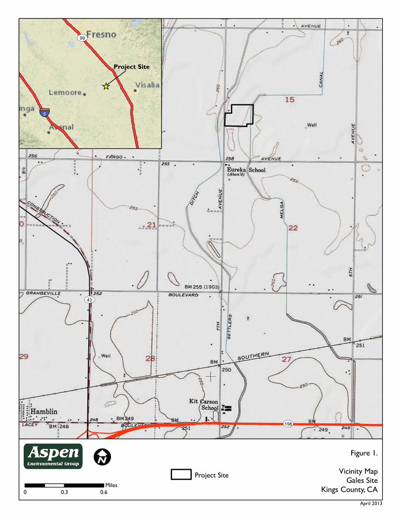
ST43
ST198
Figure 1.Vicinity Map
Gales SiteKings County, CA
I0 0.3 0.6
Miles
§̈¦5
ST99
Project Site
April 2013
_̂
Project Site

Figure 2.Gales Site
Kings County, CAI
0 0.2 0.4Miles
April 2013
#* Potential Swainson's hawk nesting siteHalf-mile search radius
Cover TypeAgriculture

Figure 3.CNDDB Map
Gales SiteKings County, CA
IAsp enEnvironm ental Group
0 2.5 5Miles
April 2013
CNDDB recordsSwainson's hawkSan Joaquin kit fox
Project Site10-mile search area

April 22, 2013 1 Aspen Environmental Group
Attachment 2: Project Photos
Photo 1: View to east from the southwest corner; agricultural field on the
project site and adjacent orchard to the right.
Photo 2: View to west from the southeast corner; agricultural field on the
project site.

April 22, 2013 2 Aspen Environmental Group
Attachment 3: Observed Species List
Latin Name Common Name Abundance / habitat PLANTS
BRASSICACEAE MUSTARD FAMILY * Coronopus didymus
Lesser swine cress Uncomm. / roadside
MALVACEAE MALLOW FAMILY * Malva parviflora Cheeseweed Occas. / roadside
POACEAE GRASS FAMILY * Poa annua
Cheat grass Uncomm. / roadside
* Triticum aestivum (?)
Common wheat Occas. / throughout
VERTEBRATE ANIMALS AVES BIRDS
ACCIPITRIDAE HAWKS, EAGLES, HARRIERS
Buteo jamaicensis
Red-tailed hawk Occasional (fly-over)
FALCONIDAE FALCONS
Falco sparverius
American kestrel Occasional
COLUMBIDAE PIGEONS AND DOVES
Zenaida macroura
Mourning dove Uncommon
FRINGILLIDAE FINCHES
Carpodacus mexicanus
House finch Uncommon
Non-native species are indicated by an asterisk, special-status species indicated by two asterisks. This list includes only species observed on the site. Others may have been overlooked or unidentifiable due to season (amphibians are active during rains, reptiles during summer, some birds (and bats) migrate out of the area for summer or winter, some mammals hibernate, many plants are identifiable only in spring).

State StatusFederal StatusScientific Name/Common Name Element Code SRankGRank
Natural Diversity DatabaseCalifornia Department of Fish and Game
Selected Elements by Scientific Name - PortraitUSGS Quads: Burris Park, Goshen, Guernsey, Hanford, Laton, Paige, Remnoy, Traver, and Waunkena.
CDFG orCNPS
SCThreatenedThreatenedAmbystoma californiense
California tiger salamanderAAAAA01180 S2S3G2G31
SCAthene cunicularia
burrowing owlABNSB10010 S2G42
1B.2Atriplex cordulata var. cordulata
heartscalePDCHE040B0 S2.2?G3T23
1B.2Atriplex cordulata var. erecticaulis
Earlimart orachePDCHE042V0 S2.2G3T24
1B.2Atriplex depressa
brittlescalePDCHE042L0 S2.2G2Q5
1B.1Atriplex minuscula
lesser saltscalePDCHE042M0 S2G26
1B.2Atriplex subtilis
subtle orachePDCHE042T0 S2.2G27
ThreatenedBranchinecta lynchi
vernal pool fairy shrimpICBRA03030 S2S3G38
ThreatenedButeo swainsoni
Swainson's hawkABNKC19070 S2G59
Cicindela tranquebarica ssp.
San Joaquin tiger beetleIICOL0220E S1G5T110
1B.2Delphinium recurvatum
recurved larkspurPDRAN0B1J0 S3G311
EndangeredEndangeredDipodomys nitratoides nitratoides
Tipton kangaroo ratAMAFD03152 S1G3T112
SCEmys marmorata
western pond turtleARAAD02030 S3G3G413
SCEumops perotis californicus
western mastiff batAMACD02011 S3?G5T414
EndangeredEndangeredGambelia sila
blunt-nosed leopard lizardARACF07010 S1G115
SCLanius ludovicianus
loggerhead shrikeABPBR01030 S4G416
Lasiurus cinereus
hoary batAMACC05030 S4?G517
EndangeredLepidurus packardi
vernal pool tadpole shrimpICBRA10010 S2S3G318
2.2Nama stenocarpum
mud namaPDHYD0A0H0 S1S2G4G519
Northern Claypan Vernal Pool CTT44120CA S1.1G120
SCSpea hammondii
western spadefootAAABF02020 S3G321
Valley Sacaton Grassland CTT42120CA S1.1G122
ThreatenedEndangeredVulpes macrotis mutica
San Joaquin kit foxAMAJA03041 S2S3G4T2T323
Commercial Version -- Dated December 01, 2012 -- Biogeographic Data Branch Page 1Report Printed on Friday, December 21, 2012 Information Expires 06/01/2013

Draft Resolution
Conditional Use Permit No. 13-02 Page 1
BEFORE THE KINGS COUNTY PLANNING COMMISSION COUNTY OF KINGS, STATE OF CALIFORNIA
IN THE MATTER OF CONDITIONAL USE ) RESOLUTION NO. 14-06 PERMIT NO. 13-02 (Gales 3 MW Solar Project) ) ) RE: 28990 Highway 41, Kettleman City WHEREAS, on May 1, 2013, Belectric, Inc. filed Conditional Use Permit No. 13-02 to develop a 3 Megawatt AC (MW) ground-mounted photovoltaic (PV) solar array on a 22 acre portion of a 28 acre parcel in Kings County located 2.11 miles northeast of the City of Hanford; and WHEREAS, the application was determined to be complete on April 23, 2014; and WHEREAS, the IS/MND was circulated for public review and comment on April 25, 2014; and WHEREAS, a Notice of Intent to Adopt a Mitigated Negative Declaration was published on April 26, 2014, providing notice that the Initial Study/Mitigated Negative Declaration (IS/MND) had been completed for the proposed Project and was available for public review and comment; and WHEREAS, the Kings County Community Development Agency distributed copies of the IS/MND to those public agencies that have jurisdiction by law with respect to the Project, as well as to other interested persons and agencies, and sought the comments of such persons and agencies; and WHEREAS, on May 27, 2014, the public review period for the proposed IS/MND for this project closed; and WHEREAS, during the public review period for the proposed IS/MND comments were received before the end of the public review period from the California Department of Fish and Wildlife; and WHEREAS, these comments resulted in minor changes to the IS/MND, none of the comments identified a new, unavoidable significant effect, nor did they result in a finding that the proposed mitigation measures in the IS/MND will not reduce potential effects to less than significant; and
WHEREAS, pursuant to CEQA Guidelines § 15073.5, recirculation of the IS/MND is not required; and WHEREAS, on May 27, 2014, the Kings County Community Development Agency recommended that the Mitigated Negative Declaration be approved for the proposal; and WHEREAS, on May 27, 2014, the Kings County Community Development Agency staff notified the applicant of the proposed recommendation on this project; and WHEREAS, on June 2, 2014, the Planning Commission held a duly noticed public hearing for CUP Number 13-02 in the Board of Supervisors Chambers of the Kings County Government Center, 1400 W. Lacey Blvd., Hanford, California; and

Draft Resolution
Conditional Use Permit No. 13-02 Page 2
WHEREAS, at the June 2, 2014, public hearing the Planning Commission received 1) a report presented by County staff that included the staff recommendation, 2) testimony from the applicant, and 3) testimony from members of the general public; and WHEREAS, the Planning Commission received testimony prior to the close of the public hearing; and WHEREAS, on June 2, 2014, after the conclusion of public testimony the Planning Commission closed the public hearing and deliberated; and WHEREAS, in order to approve CUP Number 13-02 the Planning Commission is required to make the following findings and certifications with regards to the California Environmental Quality Act: (1) The Planning Commission has reviewed and considered the IS/MND, together with the comments received during the public review and comment period, before approving the project; (2) Based on the whole record before it, including the IS/MND and the comments received during the public review period, there is no substantial evidence in the record that the proposed Project will have a significant effect on the environment; (3) The IS/MND for this Project has been completed in compliance with CEQA and is adequate; and (4) The IS/MND reflects the Planning Commission’s independent judgment and analysis; and WHEREAS, the Planning Commission has reviewed the IS/MND in its entirety, and has determined that the document reflects the independent judgment of the County; and WHEREAS, the IS/MND identified certain significant effects on the environment that, absent the adoption of mitigation measures, would be caused by the construction and operation of the Project; and WHEREAS, the Planning Commission is required, pursuant to CEQA, to adopt all feasible mitigation measures or feasible project alternatives that can substantially lessen or avoid any significant project-related environmental effects; and WHEREAS, the Planning Commission is required by Public Resources Code Section 21081.6, subdivision (a), to adopt a Mitigation Monitoring and Reporting Plan to ensure that the mitigation measures adopted by the County are actually carried out; and WHEREAS, as demonstrated by the Mitigation Monitoring and Reporting Plan, attached as Exhibit “A” to this Resolution, all of the Project’s significant environmental effects can be either substantially lessened or avoided through the adoption of feasible mitigation measures; and WHEREAS, the Planning Commission determines it appropriate to certify and adopt the Mitigated Negative Declaration, to adopt the Mitigation Monitoring and Reporting Plan, and to approve CUP Number 13-02. NOW, THEREFORE, BE IT RESOLVED AND CERTIFIED, by the Kings County Planning Commission that: I. SECTION 1: Recitals
1. The above recitals are true and correct, and the Planning Commission hereby so finds.
Draft Resolution
Conditional Use Permit No. 13-02 Page 3
II. SECTION 2: Findings Related to Proceedings
1. The Notice of Intent to Adopt a Mitigated Negative Declaration for the Project was duly prepared, noticed and properly circulated in accordance with the provisions of CEQA.
2. An Initial Study/Mitigated Negative Declaration has been conducted for the proposed Project by
the Lead Agency to evaluate the potential for any adverse environmental impact in compliance with the California Environmental Quality Act of 1970 (California Public Resources Code Section 21000 et seq.), as amended, and the State Guidelines thereto (California Code of Regulations Section 15000 et seq.).
3. The Initial Study/Mitigated Negative Declaration was duly prepared, properly circulated and
completed in accordance with CEQA. 4. After providing adequate public notice, the Initial Study/Mitigated Negative Declaration was duly
circulated in accordance with the provisions of CEQA, and a public hearing was properly noticed and was conducted by the Planning Commission in compliance with CEQA.
5. All comments received during and after the period of public review have been duly considered and
incorporated into the Initial Study/Mitigated Negative Declaration, and when necessary, replied to in accordance with the provisions of CEQA.
6. The comments resulted in minor changes to the Initial Study/Mitigated Negative Declaration, none
of the comments identified a new, unavoidable significant effect, nor did they result in a finding that the proposed mitigation measures in the Initial Study/Mitigated Negative Declaration will not reduce potential effects to less than significant.
7. The minor changes serve merely to clarify, amplify and make insignificant modifications to the
Initial Study/Mitigated Negative Declaration. 8. Pursuant to CEQA Guidelines § 15073.5, recirculation of the Initial Study/Mitigated Negative
Declaration is not required. 9. The Initial Study/Mitigated Negative Declaration was presented to this Commission, and it was
independently reviewed and considered, together with the comments received during the public review period, by this Commission prior to acting on the proposed Project.
10. The Kings County Community Development Agency provided written responses to all comments
received on the Initial Study/Mitigated Negative Declaration before certification of the Initial Study/Mitigated Negative Declaration pursuant to the provisions of CEQA.
11. The Mitigated Negative Declaration for the Project has been properly completed and has identified
all significant environmental effects of the Project, and there are no known potential environmental effects that are not addressed in the Mitigated Negative Declaration.
12. The Project has been modified with mitigation measures to eliminate significant impacts or to
reduce such impacts to a level of insignificance in all instances.
Draft Resolution
Conditional Use Permit No. 13-02 Page 4
13. The use should not be detrimental to public health and safety, nor materially injurious to
properties in the vicinity. A Mitigated Negative Declaration has been recommended for this Project. The proposed Project may have significant adverse impacts on the environment; however, those impacts can be mitigated to an insignificant level by implementing the Mitigation Monitoring and Reporting Plan attached to the Planning Commission Resolution for this project as Exhibit “A.” On the bases of the whole record (including the initial study and all comments received), there is no substantial evidence that the project will have a significant effect on the environment. The Mitigated Negative Declaration reflects the Planning Commission’s independent judgment and analysis.
14. The Planning Commission has used its own independent judgment in adopting this Resolution, in
approving the Project, in adopting and certifying the Initial Study/Mitigated Negative Declaration, and in adopting the Mitigation Monitoring and Reporting Plan.
III. SECTION 3: Certification of the Initial Study/Mitigated Negative Declaration and Adoption
of the Mitigation Monitoring and Reporting Plan
1. It is hereby certified that the Initial Study/Mitigated Negative Declaration has been completed in compliance with CEQA and is adequate.
2. It is hereby certified that the Initial Study/Mitigated Negative Declaration has been presented to
the Planning Commission, which has reviewed and considered the information and analysis contained therein.
3. It is hereby certified that the Initial Study/Mitigated Negative Declaration reflects the independent
judgment of the Planning Commission of the County of Kings. 4. The Planning Commission herby adopts the Mitigation Monitoring and Reporting Plan for this
Project. 5. The Planning Commission authorizes and directs County staff to prepare and file a Notice of
Determination within five working days following the date of adoption of this Resolution with the County Clerk-Recorder’s Office of the County of Kings and with the State of California and directs that copies of the Initial Study/Mitigated Negative Declaration be retained at the office of the Kings County Community Development Agency.
IV. SECTION 4: Consistency with the Kings County General Plan
1. The proposed Project, as recommended for approval, is consistent with the objectives and the policies of the 2035 Kings County General Plan, specifically:
A. Figure LU-16, the Kings County Land Use Map, of the Land Use Element of the 2035 Kings
County General Plan designates this site as General Agriculture (AG-20). B. Page LU-13, Section III.A.1 of the “Land Use Element” of the 2035 Kings County General
Plan states that agricultural land use designations account for a vast majority of the County’s land use. Included within this land use type are four agricultural type land use designations, Limited Agriculture, General Agriculture 20 Acre Minimum, General Agriculture 40 Acre

Draft Resolution
Conditional Use Permit No. 13-02 Page 5
Minimum, and Exclusive Agriculture. The major differences between the four Agriculture designations relate to minimum parcel size, animal keeping, and agricultural service businesses. These designations preserve land best suited for agriculture, protect land from premature conversion, prevent encroachment of incompatible uses, and establish intensity of agricultural uses in a manner that remains compatible with other uses within the County. The development of agricultural service and produce processing facilities within the Agricultural areas of the County shall develop to County standards.
C. Page LU-13, Section III.A.1. of the “Land Use Element” states that the AG-20 designation is applied to rural areas of the county north of Kansas Avenue, excluding the Urban Fringe areas of Hanford and Lemoore, Communities of Armona and Home Garden, the Naval Air Station Lemoore, the Santa Rosa Rancheria Tribal Trust Land, and other small Rural Interface pockets of urban uses. Generally characterized by extensive and intensive agricultural uses, farms within this designation have historically been smaller in size. These areas should remain reserved for commercial agricultural uses because of their high quality soil, natural and manmade waterways, scenic nature with larger concentrations of orchards, vineyards, and valley oak trees.
D. Page LU-27, Section IV.B of the “Land Use Element” of the 2035 Kings County General Plan states that the physical development of agricultural properties is regulated and implemented by the zoning ordinance.
E. Page LU-38, LU Goal B7 of the “Land Use Element” of the 2035 Kings County General Plan states that community benefiting non-agricultural uses remain compatible within the County’s Agriculture Open Space area, and are supported for their continued operation and existence.
F. Page LU-38, LU Policy B7.1.3 of the “Land Use Element” of the 2035 Kings County General Plan states that power generation facilities for commercial markets shall be allowed and regulated through the Conditional Use Permit approval process, and include thermal, wind, and solar photovoltaic electrical generating facilities that produce power.
G. Page RC-50, Section G, Objective G1.2 of the “Resource Conservation Element” states that the County will promote the development of sustainable and renewable alternative energy sources, including wind, solar, hydroelectric and biomass energy.
H. Page RC-50, Section G, Policy G1.2.2 of the “Resource Conservation Element” states the County will encourage and support efforts to develop commercial alternative energy sources in lower priority agricultural lands within Kings County, when appropriately sited.
I. Page RC-51, Section G, Policy G1.2.7 of the “Resource Conservation Element” states the County will require commercial solar and wind energy systems to be reviewed as a conditional use permit pursuant to the procedures of the Kings County Zoning Ordinance.
V. SECTION 5: Consistency with the Kings County Zoning Ordinance
1. The use complies with the applicable provisions of the ordinance, specifically: The proposed Project, as recommended for approval, is consistent with the Kings County Zoning Ordinance. A. Article 4, Section 402.D.21 of the General Agricultural (AG-20) District lists solar
photovoltaic electrical generating facilities that commercially produce power for sale, which comply with all local, regional, State, and Federal regulations as a conditional use subject to Kings County Planning Commission approval.

Draft Resolution
Conditional Use Permit No. 13-02 Page 6
B. Article 19, Section 1908.H of the Kings County Zoning Ordinance states that the when an application is submitted for a solar photovoltaic electrical facility for commercial sale and distribution of electrical power, the following findings shall be made before granting a conditional use permit:
(1) The proposed site is located in an area designated as either “Very Low Priority,” “Low
Priority,” or “Low-Medium Priority” land according to Figure RC-13 Priority Agricultural Land (2035 Kings County General Plan, Resource Conservation Element, Page RC-20). “Medium Priority” land may be considered when comparable agricultural operations are integrated, the standard mitigation requirement is applied, or combination thereof. a. As shown in Figure 7 of the Initial Study/Mitigated Negative Declaration (IS/MND),
the Gales Solar site is designated Medium Priority Land. Cancellation of the existing FSZ contract on project land (for which Mitigation Measure II-3 has been proposed) requires the purchase or acquisition of off-site agricultural mitigation land at the appropriate ratio (1:1) for the life of the project. If FSZ contract cancellation does not occur, project option 2 would be implemented, which involves integrating comparable agricultural operations with the proposed solar use (see the Agriculture and Forest Resources Section of IS/MND for discussion).
(2) The proposed site is located within 1 mile of an existing 60-kV or higher utility electrical line. a. The proposed site is located immediately adjacent to a 12kV utility “distribution”
electrical line, to which the project will directly interconnect via a “line tap.” A smaller, distributed-level solar power plant such as the Gales 3MW project can and preferably does connect to a distribution line rather than the larger 60kV transmission (or sub-transmission) lines. Connecting to a larger capacity transmission line is significantly more costly, is not a requirement for projects of this size, and typically is not done due to project economics. In addition, it should be noted that a 115kV line runs in a north-south direction along the west side of 7th Avenue.
(3) Agricultural mitigation is proposed for every acre of Prime Farmland, Unique Farmland, or Farmland of Statewide Importance converted for a commercial solar facility. The agricultural mitigation shall preserve at a ratio of 1:1 an equal amount of agricultural acreage of equal or greater quality in a manner acceptable to the County that coincides with the life of the project. Agricultural mitigation on land designed “Medium-High” or higher priority land shall preserve an equivalent amount of agricultural acreage at a ratio of 2:1. a. See the discussion for Finding 3.B.(1) above.
(4) The project includes a reclamation plan and financial assurance acceptable to the County that ensures the return of the land to a farmable state after completion of the project life, and retains surface water rights. a. The project would provide a reclamation plan and financial assurance acceptable to the
County prior to issuance of construction permits. The reclamation plan and financial assurance ensures the removal of all project fixtures, equipment, and non-agricultural roads, and will require restoration of compacted soil after completion of the project life. The land would retain water rights; therefore, water rights would not have to be replaced.
(5) The project includes a pest management plan and weed abatement plan to protect adjacent farmland from nuisances and disruption.

Draft Resolution
Conditional Use Permit No. 13-02 Page 7
a. The project would provide a pest management plan and weed abatement plan to protect adjacent farmland from nuisances and disruption prior to issuance of construction permits. The weed abatement plan would ensure that combustible vegetation or agricultural products on and around the project boundary would be actively managed by the project owner or its affiliates during both the construction and operation phases of the project to minimize fire risk. Combustible products would be limited in height or removed through a combination of sheep grazing and mechanical equipment. Herbicides may be applied if warranted by site conditions as specified in the weed abatement plan. Additionally, the project would include fire breaks around the project boundary in the form of interior gravel driveways subject to County standards. The pest management plan would reduce anticipated nuisance impacts to adjacent farmland from pests inhabiting project facilities. Rodenticide and herbicide would be selected and used in a manner that minimizes impacts to protected biological species. The pest management plan would set action thresholds, identify pests, specify prevention methods as a first course of action, specify control methods as a second course of action, and establish a qualitative performance goal of nuisance reduction to adjacent farmland.
(6) The project establishes internal access roads that do not exceed a maximum distance of 300 feet between lanes. a. The project establishes internal access driveways that do not exceed a maximum
separation distance of 300 feet from edge of driveway to edge of driveway. (7) The project includes a solid waste management plan for site maintenance and disposal of
trash and debris. a. The project would provide a solid waste management plan for site maintenance and
disposal of trash and debris prior to issuance of construction permits. (8) The project site is located on Williamson Act or Farmland Security Zone contracted land,
unless it meets the principles of compatibility under Government Code Section 51238.1(a). Otherwise, the contract is proposed for cancellation or is eligible and converts to a Solar Easement. a. As discussed in detail in the Project Description section and Agriculture and Forest
Resources section of the IS/MND, the applicant would implement one of two options with respect to the site’s existing Farmland Security Zone contract.
[1] Option 1: The first option proposes cancellation of the existing FSZ contract. Under
this option agricultural operations would be discontinued on the site during the lifetime of the project. The temporary use of the land for solar development would represent a very small portion of the overall, currently designated farmland in Kings County, as well as of the total amount of land within FSZ Contract No. 00011 (approximately 5 percent). Temporarily (i.e. for the lifetime of the project) removing the project site from agricultural production would have the potentially adverse impact of converting “Farmland of Statewide Importance” to nonagricultural use. Implementation of Mitigation Measures II-1, II-2 and II-3 would reduce this impact to a less-than-significant level by requiring agricultural operations off-site, (i.e. on mitigation land), soil reclamation and associated financial assurances.
[2] Option 2: If FSZ cancellation is unsuccessful, this project option would consist of
solar generation along with continued on-site agricultural operations. Under this

Draft Resolution
Conditional Use Permit No. 13-02 Page 8
option, the applicant would prepare and implement, during the operational life of the project, an Agriculture Management Plan (AMP) that completely satisfies the Williamson Act principles of compatibility and the performance standards established in Government Code Section 51238.1. Under this option, a “continuous agricultural area” would be cultivated with strawberries, sweet corn, and/or melons, to produce an equivalent or greater economic output than the entire parcel has historically yielded, with the remainder of the project lease parcel to be utilized for sheep grazing/husbandry, as discussed below, in order to produce an equivalent or greater productivity output compared to the site’s historical output. If the second option is selected then the use will not significantly compromise the long-term productive agricultural capability of the subject contracted parcel or on other contracted lands in agricultural preserves. If continued agricultural operations can yield equivalent economic and productivity return as compared to existing (pre-project) conditions the project could still have potential adverse impacts by conversion of “Farmland of Statewide Importance” to a non-agricultural use, but only if long-term production on the site is significantly compromised by not reclaiming the soil and/or a lack of financial assurances. Implementation of Mitigation Measures II-1 and II-2 would reduce this impact to a less-than-significant level by requiring soil reclamation after the life of the project via financial assurances. Government Code Section 51238.1. (a) Uses approved on contracted lands shall be consistent with all of the following principles of compatibility: (a) The use will not significantly compromise the long-term, productive
agricultural capability of the subject contracted parcel or parcels or on other contracted lands in agricultural preserves.
1) The applicant’s proposed alternative to cancellation of the Farmland
Security Zone contract on the property contemplates, in addition to sheep grazing/husbandry within the solar arrays, the continued farming operations on a portion of the 22-acre solar lease area with high value crops to produce an equivalent, overall economic and productivity return as has historically existed on the subject property. A ten-year history of the average agricultural economic output for the project site is shown in Table 1 below.

Draft Resolution
Conditional Use Permit No. 13-02 Page 9
Table 1
Project Site Cropping History and County Data
Crop
Year Subject Property
Production (Tons Per Acre) and
Value
King’s County Data1
Harvested Acreage –
Total Kings County
Production (Tons) Per
Acre
County Average
Value per Ton
Value per Acre per
Year
Corn Silage
2012 Similar to county averages
58,243 25.94 $49.50 $1,284.03 2011 57,220 25.92 $48.60 $1,259.71
20102 56,745 26.06 $34.60 $ 901.68 20092 63,232 26.99 $25.70 $ 693.64 2008 73,944 27.00 $48.10 $1,298.70 2007 55,383 26.96 $33.00 $889.68 2006 66,875 26.04 $24.00 $624.96 2005 65,502 25.30 $27.30 $690.69 2004 55,233 23.22 $25.00 $580.50 2003 50,298 24.63 $21.36 $526.10
Ten Year Average 54,443 23.19 $28.77 $745.83 Wheat Silage
2012 Similar to county averages
57,489 15.75 $40.40 $636.30 2011 57,220 15.89 $39.60 $629.24
2010
48,883
17.29
$25.70
$444.35
2009 54,233 17.86 $21.90 $391.13 2008 57,727 17.80 $39.10 $695.98 2007 32,540 18.53 $26.00 $481.78 2006 38,318 14.72 $23.00 $338.56 2005 40,675 13.92 $22.30 $310.42 2004 25,756 13.80 $21.00 $289.80 2003 20,788 13.81 $18.61 $257.00
Ten Year Average 43,363 15.94 $27.76 $447.46 Income per Acre per Year Assuming Two Crops Per Year $1,193.29
Income per 22-Acre Lease Parcel per Year of Combined Crops Averages $26,253.26 1. Source: Kings County Department of Agriculture, Measurement Standards and Kings County
Agricultural Commissioner 2. Alfalfa grown at subject property for half of 2009 and 2010; the average yield and monetary value per
acre for alfalfa is similar to (and slightly lower than) corn silage so not listed out separately.
Table 1 indicates that the combined “double crop” average (e.g., two crops are typically grown per year) of both crops historically grown (primarily corn and wheat silage) has yielded $1,193.29/acre/year over the past ten years, or approximately $26,253.26/year for the entire 22-acre lease parcel.

Draft Resolution
Conditional Use Permit No. 13-02 Page 10
As shown in Table 2, use of even a 1-acre portion of the 22-acre lease area for high value seasonal crops, such as strawberries, sweet corn, and/or melons can produce an equivalent or greater economic return than the entire parcel has historically yielded. The tentative proposal for the continued agricultural use of the subject property under Option 2 is therefore the following:
[a] While the solar farm is being constructed in the southern 20-acre
portion, prepare a 2-acre portion of the site for high-value crop production in the northernmost two acres of the 22-acre lease area.
[b] Following construction of the solar farm and the filing of a Notice of
Termination of coverage under the California NPDES General Permit (for discharges of storm water associated with construction activity), plant high-value crops within the first three years of operation in the 4.5-acre area shown on Figure 5.
[c] In addition to the planting of high-value crops on the 4.5-acre area
described above, sheep grazing/husbandry activities would be performed on the remainder of the project lease area, in-between and beneath the solar panel structures. As the expected annual income of sheep grazing/husbandry is highly variable and depends on many factors, the expected income is not included in this analysis.
The productivity and economic yields shown in Table 2 are based on ten-year historical California averages. There is a potential for even higher yields on the subject property by using enhanced farming methods or specialty techniques, including hydroponic growing methods, multi-species “co-farming”, locally-produced (“farm-to-table”) product marketing, organic produce, and/or rotation of crops in seasonal or popular demand. Drip-irrigation techniques are proposed for all alternate crops to address water availability and conservation issues12. Hydroponic crops require less water and soil-less gardening eliminates weeds while reducing or eradicating soil-borne pests and diseases.

Draft Resolution
Conditional Use Permit No. 13-02 Page 11
Table 2
Proposed Alternative Crops for Gales Solar Site
Proposed Alternative High-Value Crop
Yield
(tons per acre)
Price
(per ton)
Future Annual Expected Total Financial Yield (1 Acre Out of 22-Acre Lease
Parcel)1
Future Annual Expected Total Financial Yield (4 Acres out of 22-Acre Lease
Parcel)
Historical Average Annual Total Financial
Yield (Entire 22-Acre Lease Parcel)
Vertical (hydroponic) Strawberries
282
$1,3002,3
$36,400
$145,600
$26,253.26
Traditionally Farmed Strawberries3
7.5
$1,300
$9,750
$39,000
Sweet Corn4
8.9
$432
$3,8005
$15,200
Pumpkins/ Specialty Melons and Squash6
14
$240
$3,3607
$13,440
1. Total financial yield conservatively assumes only one acre of production on entire 22-acre parcel – this number is expected to go as high as 15 acres depending on water availability, ultimate site design and demand for agricultural products produced.
2. Conservatively assumes half of yield seen in other areas of California (28 instead of 56 tons/acre), and uses California ten-year average price of $0.65/lb., however price is viewed as conservative as locally marketed strawberries have been shown to be sold as high as $3/lb. Source: http://www.greentechmedia.com/articles/read/the-farm-of-the-future-will-grow-plants-vertically-and- hydroponically
3. Minimum acreage to be grown would likely be an average of 4 acres totaling $39,000/year for the 4-acre portion of the lease parcel. Assumes California ten year average (2003-2012) yield of 7.5 tons/acre and $0.65/pound price for fresh strawberries. Source: Kings County Agricultural Commissioner and http://usda.mannlib.cornell.edu/MannUsda/viewDocumentInfo.do?documentID=1381
4. Assumes California ten year average (2000-2009) yield of sweet corn 8.9 tons per acre and price of $432/ton. Source: http://usda.mannlib.cornell.edu/MannUsda/viewDocumentInfo.do?documentID=1564
5. Minimum acreage to be grown would likely be an average of 4 acres totaling $15,200/year for the 4-acre portion of the lease parcel.
6. Assumes California one year (2013) average for pumpkins of 14 tons per acre and 2012 average of $240/ton. Other types of high value squash and melons can also be grown to meet local/specialty market demand. Source: http://www.ers.usda.gov/topics/in-the-news/pumpkins-background-statistics.aspx#.UnEF10rD-70%20
7. Minimum acreage to be grown would likely be an average of 4 acres totaling $13,440/year for the 4-acre portion of the lease parcel.
An Agriculture Management Plan for the project (prepared under option 2) would ensure maintenance of sustainable, agricultural commercial operations on the site throughout the life of the project. Implementation of a Soil Reclamation Plan would return the entire 22-acre solar project site to pre-project conditions following site decommissioning. It should be reiterated that the project site constitutes only approximately 5 percent of the total 517-acre area of FSZ Contract No.

Draft Resolution
Conditional Use Permit No. 13-02 Page 12
00011 and less than one-half of one percent of FSZ contracted land in Kings County.
(b) The use will not significantly displace or impair current or reasonably
foreseeable agricultural operations on the subject contracted parcel or on other contracted lands in agricultural preserves.
1) To remain Williamson Act compatible and to be in compliance with the
project’s conditional use permit, the owner/operator would fully commit to and ensure successful implementation of an Agriculture Management Plan, consistent with the principles of compatibility and performance standards outlined in Government Code section 51238.1. Alternative agricultural operations proposed at the project site for the life of the project would yield a similar or increased, overall economic and productivity return as has historically existed on the subject property (see Tables 1 and 2 above). As shown on both the fixed-tilt and tracking Site Plans, a 4.5-acre “Continuous Agricultural Area” for high-value crops has been incorporated into the site design. This represents approximately 20% of the total 22-acre lease area. In addition, sheep grazing/husbandry activities are proposed on approximately 16.5 acres of the remaining acreage (or a total of almost 95% of the remaining site footprint).
The development and operation of the Gales Solar site is self-contained, does not include elements that would facilitate expansion (i.e., over-sized infrastructure), nor does the operation of the project pose harm or create issues of incompatibility with the operation of agricultural activities on adjacent properties. Furthermore, the project site constitutes only approximately 5 percent of the total 517-acre area of FSZ Contract No. 00011.
(c) The use will not result in the significant removal of adjacent contracted land
from agricultural or open-space use.
1) The site is surrounded by lands containing FSZ and Williamson Act contracts, with the single exception of the small rural residential area north of the project site, consisting of four homes. The project site constitutes only approximately 5 percent of the total 517-acre area of FSZ Contract No. 00011 and less than one-half of one percent of FSZ contracted land in Kings County. It would be speculative to assume that the introduction of a 22-acre solar facility on the project site would lead to removal of adjacent contracted land from agricultural or open space use for similar purposes. The project would be self-contained and would not provide new available infrastructure that could be used by other power generation projects. Moreover, a low likelihood exists for the demand of additional energy projects on nearby farmland, as locating these types of “distributed level” renewable energy projects is physically limited to the (low) capacity on a given electrical distribution line. That is, it is unlikely that additional solar farms can physically be placed in the vicinity due to physical limits to carry

Draft Resolution
Conditional Use Permit No. 13-02 Page 13
electricity on the power lines. Therefore, the proposed use will not induce additional solar generation facilities to site on adjacent parcels.
In addition, the solar facility is not an intensive use that would create conflicts with neighboring agricultural operations on contracted lands and somehow lead to the inability of adjacent landowners to continue farming.
If the DOC approves the applicant’s request for cancellation of the existing Williamson Act/FSZ contract for the 22-acre lease area, then the project would not conflict with an existing Williamson Act contract. If the DOC does not approve cancellation of the FSZ contract, then the applicant would conduct on-site agricultural operations that would be consistent with the principles of compatibility of California Government Code Section 51238.1, as discussed above in Project Option 2 – Continue Agricultural Operations On-site. By doing so, the project would not conflict with the existing Williamson Act contract over the property.
VI. SECTION 6: Consistency with the California Land Conservation (Williamson) Act
1. The project site (APN: 014-090-033) is located within an established agricultural preserve and is restricted by a Farmland Security Zone Contract. See Finding V.B.(8) above for Land Conservation (Williamson) Act Consistency Findings.
VII. SECTION 7: Consistency with the Flood Damage Prevention Ordinance (Chapter 5A of the
Kings County Code of Ordinances)
1. The site is within Other Areas Zone X as shown on the National Flood Insurance Program, Flood Insurance Rate Map (FIRM), Map Number 06031C0205C, dated June 16, 2009. There are no development restrictions associated with Other Areas Zone X since these are areas determined to be outside the 0.2 percent annual chance floodplain.
VIII. SECTION 8: Kings County Enterprise Zone
1. The Project site is not located within the Kings County Enterprise Zone. IX. SECTION 9: Consistency with the Kings County Airport Land Use Compatibility Plan
1. The Project site is not located within an Airport Compatibility Zone. X. SECTION 10: Consistency with the Kings County Septic Tank Absorption Field Minimum
Requirements
1. The Project site is not located within an area requiring engineering for any new septic systems that are installed.
XI. SECTION 11: Conditions of Approval The Commission adopts the following conditions of approval for CUP No. 13-02:
Draft Resolution
Conditional Use Permit No. 13-02 Page 14
KINGS COUNTY COMMUNITY DEVELOPMENT AGENCY – PLANNING DIVISION: Contact Sandy Roper of the Kings County Community Development Agency at (559) 852-2685 regarding the following requirements: 1. All proposals of the applicant shall be conditions of approval if not mentioned herein. 2. Prior to initiation of construction, the applicant shall conduct a site visit in concert with the
Cultural Department of the Santa Rosa Rancheria in order to provide an opportunity for the Rancheria to assess the site and discuss their recommendations. During the site visit a cultural sensitivity class will be taught by the Cultural Department of the Santa Rosa Rancheria for the construction crew. Prior to initiation of construction, the applicant shall consult with the Cultural Department of the Santa Rosa Rancheria to determine if they would like to provide one Tribal Cultural Consultant (TCC) during project grading. The Applicant and the Santa Rosa Rancheria shall enter a reburial agreement as well as a curation agreement for any artifacts that may be discovered during construction (per CEQA Guidelines, California Code of Regulations, Title 14, Section 15064.5). If prehistoric artifacts are found, the project archaeologist will work with the TCC to determine their significance and work with the Cultural Department of the Santa Rosa Rancheria and the landowner to identify potential reburial options, as requested by the Tribe in their February 21, 2013, letter.
3. The site plan for the project is approved in concept. However, it is understood that during the actual design of the project that either of the following minor alterations to the site plan may be necessary: 1) structural alterations; and/or 2) alterations to the location of structures. Any minor alterations shall comply with the following requirements:
A. The site shall be developed in substantial compliance with the conceptually approved site
plan. Development of the site shall be considered substantially consistent with the approved conceptual site plan if any minor structural alteration is within ten (10) percent of the square footage shown on the conceptually approved site plan or up to a 2,500 square foot increase in structural size, whichever is less, and the minor structural alteration complies with coverage standards.
B. A minor alteration of the location of a structure shall be considered substantially consistent with the approved conceptual site plan if the new location of the structure complies with all setback requirements for the zone district that the project site is located in.
C. Any minor alteration that would make it necessary to modify or change any condition of approval placed on the project would require resubmittal of the application to amend the approval of the Conditional Use Permit.
D. No expansion of use, regardless of size, which would increase the projected scale of operations beyond the scope and nature described in this Conditional Use Permit application, will be allowed. Any expansion that is a substantial change from the conceptually approved site plan, will require either an amendment to the approved Conditional Use Permit or a new zoning permit.
4. The development shall comply with all regulations of Zoning Ordinance No. 269, with particular
reference to the General Agricultural (AG-20) Zone District standards contained in Article 4. 5. Pursuant to Section 1605.B.1.a.1 of the Kings County Zoning Ordinance, No solid fence, wall,
hedge or shrub exceeding three (3) feet in height shall be erected, planted or maintained within a

Draft Resolution
Conditional Use Permit No. 13-02 Page 15
required Traffic Safety Visibility Area. Traffic Safety Visibility Area is defined as a space set aside on a lot in which all visual obstructions, such as structures, fences and plantings that inhibit visibility and thus have the potential to cause a hazard to traffic and pedestrian safety are prohibited, as follows: a. Area adjacent to a driveway on any lot - the Traffic Safety Visibility Area is that area on
the street side of a diagonal line connecting points, measured from the intersection of the driveway (located on the property or adjoining parcel) and the street right of way line, twenty (20) feet along the side of the driveway and twenty (20) feet along the street side of a lot.
b. On a corner lot - the Traffic Safety Visibility Area also includes that area of a corner lot on the street side of a diagonal line connecting points, measured from the property corner where the streets intersect, set back one (1) foot for every one (1) mile per hour of the posted speed limit along each street.
6. Pursuant to Section 1606.C.1 of the Kings County Zoning Ordinance unless otherwise stated, the
following signs are allowed as a permitted use and do not require a sign permit, site plan review or conditional use permit. All signs shall be located outside of the public right-of-way and shall not be located within a traffic safety visibility area if over three (3) feet in height. Unless a different setback is specified for a particular zone district, the minimum setback distance for all signs over three (3) feet in height shall be ten (10) feet from property lines. Signs shall be permitted only as follows in Agricultural (A) Districts:
A. Name plates or signs, not directly illuminated, with an aggregate area of not more than
forty (40) square feet pertaining to a permitted use, permitted use with site plan review or conditional use conducted on the site.
B. Signs exceeding forty (40) square feet in structural area and up to one-hundred-fifty (150) square feet in structural area which are incidental and pertaining to a permitted or conditional use may be permitted subject to a site plan review. Such signs may be located on the same parcel or an adjacent parcel used in conjunction with the permitted or conditional use. Signs exceeding forty (40) square feet in structural area may be illuminated and shall be thirty (30) feet from property lines adjacent to a road.
C. One non-illuminated on-site sign real estate sign or subdivision not exceeding thirty-two (32) square feet in structural area with copy on both sides pertaining to the sale, lease, rental or display of a structure or land per Section 1606.B.2.a.
D. Directional or information (other than advertising) signs not exceeding two hundred and forty (240) square feet in area located adjacent to a state highway or a county road within an area limited by points not closer than one-fourth (¼) mile or further than three-fourths (¾) mile from a frontage road turnoff, listing commercial establishments accessible via the frontage road, and further provided that not more than four (4) such signs shall be permitted on each side of the highway or county road.
E. Signs not exceeding two hundred forty (240) square feet in area located adjacent to a state highway or county road that is classified as an arterial or collector road (including such designations as urban or rural, major or minor) giving direction to or information about Kings County cities, communities, or rural service centers which are accessible by such state highways or county roads or direct routes consisting of combinations thereof, provided that such signs shall be limited to four (4) per city, community or rural service center regardless of the sign's location in this district, and further provided that such signs
Draft Resolution
Conditional Use Permit No. 13-02 Page 16
shall not contain information pertaining to a subdivision of land or private development, commercial establishments or quasi-public developments.
F. Non-illuminated temporary construction signs in accordance with Section 1606.B.2.c. G. Political and Campaign Signs in accordance with Section 1606.B.3. H. Placing a sign on property which is restricted by contract under the California Land
Conservation “Williamson” Act of 1965 shall be prohibited, except for temporary signs (pursuant to Section 1606.B.2.a, c, and d), political and campaign signs (pursuant to Section 1606.B.4), and signs incidental to a permitted use, permitted use with site plan review, or conditional use which are consistent with the Uniform Rules for Agricultural Preserves in Kings County.
7. Exterior lighting shall be hooded so as to be directed only on site. 8. A minimum of four (4) off-street parking spaces shall be provided and that such parking shall be
installed in accordance with the Kings County Improvement Standards. 9. All parking areas, aisles, and driveways shall be surfaced and maintained so as to provide a
durable, dustless surface. Section 303.G. and Drawing 3036 of the Kings County Improvement Standards requires Cutback Asphalt over four (4) inches of Decomposed Granite under the “Rural Alternative.” (Note: The Kings County Zoning Administrator hereby reserves the right to require additional improvements to the parking area and driveway if at any time in the future the decomposed granite surface deteriorates and either a dust problem is created due vehicles driving on the decomposed granite surface, or a mud problem is created due to vehicles tracking mud onto County Roads.)
10. All open and unlandscaped portions of the lot shall be maintained in good condition, free from
weeds, dust, trash and debris. 11. The minimum yard requirements from property line to a structure shall be as follows:
A. The minimum front yard setback shall be either fifty (50) feet from the front property line or eighty feet from the center of the road, whichever is greater.
B. The minimum side yard setback shall be ten (10) feet from the side property line. C. The minimum rear yard setback shall be ten (10) feet from the rear property line.
12. The minimum distance between structures shall be ten (10) feet. 13. The applicant shall comply with all requirements of, and obtain any necessary permits from, the
San Joaquin Valley Air Pollution Control District (SJVAPCD). Questions concerning SJVAPCD requirements should be direct to Jessica Willis at (559) 230-5818.
14. The applicant shall comply with all requirements of, and obtain any necessary permits from, the
California Regional Water Quality Control Board (CRWQCB). Questions concerning CRWQCB requirements should be direct to David Sholes at (559) 445-6279.
15. The applicant shall comply with all adopted rules and regulations of the Kings County Public
Works Department, Fire Department, and the Environmental Heath Services Division of the Health Department, and all other local and state regulatory agencies.

Draft Resolution
Conditional Use Permit No. 13-02 Page 17
16. Pursuant to Section 14-38(d) of the Kings County Code of Ordinances, a “Notice of Disclosure
and Acknowledgment of Agricultural Land Use Protection and Right to Farm Policies of the County of Kings” shall be signed, notarized, and recorded.
17. Pursuant to Section 66020(d)(1) of the California Government Code, the owner is hereby notified
that the 90-day approval period in which the applicant may protest the imposition of fees, dedications, reservations, or other exactions, begins on the date that Planning Commission Resolution No. 13-05 is adopted.
18. Sales or use tax may apply to business activities on the site. The applicant may seek written
advice regarding the application of tax to your particular business by writing to the nearest State Board of Equalization office. For general information, please call the Board of Equalization at 1-800-400-7115.
19. Prior to the issuance of a building permit, the applicant shall submit a Soil Reclamation Plan for
review and approval by Community Development Agency staff. The plan shall contain an analysis of pre-project baseline soil conditions, and shall contain specific measures to restore the soil to its pre-project condition, including removal of all fixtures, equipment, non-agricultural driveways, and restoration of compacted soil. Reclamation shall be completed within six months of the expiration of the use permit.
20. Prior to the issuance of a building permit, the applicant shall post a performance bond or similar
instrument to ensure completion of the activities under the Reclamation Plan. Financial assurances for the Reclamation Plan will be reviewed every 5 years by the Kings County Community Development Agency to determine if finances are sufficient to perform reclamation of the Project. The assurance must be adjusted if, during the five year review, finances are determined to be insufficient to perform reclamation of the Project.
21. Additional annual service impact fees affecting the Kings County Fire and Sheriff departments
will not be billed to the applicant. Instead, the applicant will be responsible to pay for services rendered by the two departments during times of emergency when services are provided.
22. All mitigation measures in the Initial Study/Mitigated Negative Declaration and the Mitigation
Monitoring and Reporting Plan that pertain to CUP No. 13-02 are adopted as conditions of this approval, and included in the Conditional Use Permit.
23. Within eight (8) days following the date of the decision of the Kings County Planning
Commission, the decision may be appealed to the Kings County Board of Supervisors. The appeal shall be filed with the Clerk of the Board of Supervisors.
23. This Conditional Use Permit shall lapse and shall become null and void three (3) years following
the date that the Conditional Use Permit became effective, unless prior to the expiration of three (3) years the proposed use has been established. A Conditional Use Permit involving construction shall lapse and shall become null and void three (3) years following the date that the Conditional Use Permit became effective, unless prior to the expiration of three (3) year a building permit is issued by the Building Official and construction is commenced and diligently pursued toward completion on the site that was subject of the Conditional Use Permit application.

Draft Resolution
Conditional Use Permit No. 13-02 Page 18
24. This Conditional Use Permit may be renewed for additional periods of time, if an application (by
letter) for renewal of the Conditional Use Permit is filed with the Planning Commission prior to the permit’s expiration date.
XII. SECTION 12: Other Agency’s Comments, Standards and Regulations The following departments and agencies have provided comments, standards, and regulations concerning the proposed project. The Planning Commission has no authority to modify, amend, or delete any of these comments, standards, and regulations but lists them here as information to the applicant. Appeals for relief of other agency’s standards and regulations must be made through that department’s or agency’s procedures, not through the Zoning Ordinance procedures. However, the applicant shall comply with all adopted rules and regulations of the Kings County Public Works Department, Fire Department, and the Environmental Heath Services Division of the Health Department, and all other local and state regulatory agencies. Failure of the applicant to comply with all adopted standards and regulations of all other local and state regulatory agencies is a violation of this conditional use permit (see Planning Division Condition No. 15 above) and could result in revocation of this conditional use permit. KINGS COUNTY COMMUNITY DEVELOPMENT AGENCY - BUILDING DIVISION Contact Darren Verdegaal at the Kings County Community Development Agency - Building Division at (559) 852-2683, regarding the following comments: 1. Building permits must be obtained from the Building Division of the Kings County Community
Development Agency for any structures, plumbing, electrical, or mechanical work. 2. Failure to obtain a building permit for any structure, prior to commencing construction, which
requires a building permit, will result in the payment of a double fee. Payment of such double fee shall not relieve any person from fully complying with the requirements of Kings County Code of Ordinances, Chapter 5 in the execution of the work or from any other penalties prescribed therein.
3. A minimum of two (2) sets of plans and calculations signed by an architect or engineer licensed to
practice in the State of California shall be required for the proposed work. 4. All special inspection reports shall be provided to the Building Division prior to requesting a final
inspection. 5. The applicant is responsible for contacting the Building Division to request a final inspection of
the structures prior to occupying the structures and prior to startup of the operation. No building or structure shall be used or occupied until the Building Division has issued a Certificate of Occupancy.
6. All drive approaches and durable dustless surfaces shall be installed prior to the final inspection
and maintained as per County Standards. 7. If the facility will have employees on-site for maintenance of the system an accessible restroom
shall be provided and shall comply with Section 1115B of the California Building Code. This may be accomplished by either construction of a permanent structure or use of a chemical toilet with a regular maintenance schedule.
Draft Resolution
Conditional Use Permit No. 13-02 Page 19
8. Pursuant to Section 1129B of the California Building Code one (1) van accessible parking space,
allowing room for individuals in wheelchairs, on braces or crutches to get in and out of an automobile onto a level surface, suitable for wheeling and walking shall be provided. The parking space shall be 9’ x 20’ with an 8’ wide loading and unloading aisle placed on the side opposite the driver’s side. The surfacing of the parking space, loading and unloading aisle and the accessible path from the space to the entrance of the building shall be either asphalt concrete or concrete.
9. The development shall comply with all applicable Americans with Disability’s Act (ADA)
requirements, especially Section 1127B of the California Building Code, which states that site development and grading shall be designed to provide access to all entrances and exterior ground-floor exits, and access to normal paths of travel. The accessible route of travel shall be the most practical direct route between accessible building entrances, accessible site facilities and the accessible entrance to the site, including but not limited to access from the accessible parking space to accessible building entrances.
10. A soils report, prepared by a qualified soils engineer, shall be provided to the Building Division
prior to issuance of building permits. 11. The facility shall meet the requirements of the State of California Model Water Efficient
Landscape Ordinance. Landscape and irrigation plans shall be provided to the Community Development Agency for review and approval prior to building permit issuance.
12. All construction shall conform to the 2013 California Code of Regulations Title 24 which consist
of the California Building Code, California Electrical Code, California Mechanical Code, California Plumbing Code, and California Energy Code, California Fire Code and California Green Building Standards Code.
KINGS COUNTY PUBLIC WORKS DEPARTMENT Contact Mike Hawkins of the Kings County Public Works Department at (559) 852-2708 regarding the following requirements: 1. All requirements required hereafter shall conform to the Kings County Improvement Standards. 2. All other alternatives to Public Works requirements must be approved by the Kings County Public
Works Department. 3. The applicant shall secure an encroachment permit for any work in the County right-of-way. 4. The applicant shall provide asphalt concrete drive approach(es).
5. Access to the site from a public road must be provided, and must be approved by the County. 6. Traffic ingress and egress shall be per the approved site plan. 7. Drive approach(es) shall be constructed in accordance with Section 205 of the Kings County
Improvement Standards and shall be 2.5” Asphalt-Concrete over 5” of Class II Base Rock.

Draft Resolution
Conditional Use Permit No. 13-02 Page 20
8. Encroachment permits for drive approaches and other work in the right of way must be obtained from the Public Works Department.
KINGS COUNTY FIRE DEPARTMENT: Contact Rick Smith of the Kings County Fire Department at (559) 852-2885 for the following comments: 1. Rows of solar panels shall not exceed 300 feet in length. 2. There shall be a minimum of 4 feet of separation between rows to allow access for fire
suppression personnel. 3. There shall be access roads of an all-weather surface capable of supporting heavy fire apparatus
between the 300 foot sections of solar panels to allow fire apparatus access to the panels so that no portion of any panel is greater than 150 feet from fire suppression access. The access roads shall be maintained and completely surround the solar panels to allow access from any side or end. Widths of access roads shall be determined by the Fire Marshal.
4. The solar field shall be kept clear of combustible weeds and debris. 5. The solar fields shall be protected to prevent public access. 6. Fire Department requires a Knox box or other approved system to store and secure keys for any
fence or buildings within the property. 7. Applicant shall provide training for fire personnel to be able to interrupt electrical power safely for
emergency incidents requiring fire suppression or rescue activities. 8. Architects, Engineers and Designers shall provide detailed plans for review of the project and shall
meet with the Fire Marshal in a timely manner upon his request for clarification of any issues. 9. Any fire suppression systems or fire flow requirements will be dependent upon project facilities
and review of the project specifications. 10. Fire Department reserves the right to add additional comments or requirements depending upon
the hazards involved with the project. KINGS COUNTY HEALTH DEPARTMENT: Contact Lee Johnson of the Kings County Department of Environmental Health Services at (559) 852-2631 regarding the following comments: 1. If hazardous materials at or above threshold reporting quantities (55 gallons of a liquid, 500
pounds of a solid, or 200 cubic feet of a gas) will be kept on site, the facility must file a Hazardous Materials Business Plan online at http://cers.calepa.ca.gov within 30 days of beginning operations. Hazardous materials are broadly defined, and include fuel, lubricants, antifreeze, motor vehicle batteries, welding gases, paints, solvents, glues, agricultural chemicals, etc. Please contact our office if you require assistance with the online registration process.
Draft Resolution
Conditional Use Permit No. 13-02 Page 21
2. Any quantities of hazardous wastes generated by the facility operation must be managed in accordance with Federal, State, and local laws and regulations. Hazardous wastes cannot be disposed of into the municipal waste stream or onsite sewage disposal system. The owner/operator must contact our office at with any questions regarding proper management and reporting of any hazardous wastes associated with this operation.
3. Given the proximity of LNAS and frequent air traffic over the site, as well as adjacent highway
and road traffic, the sites must be designed and constructed so as to minimize light reflectivity that might be hazardous for aircraft or vehicles.
4. As per the Kings County Public Health Officer, Coccidiodes immiti, the fungus that causes valley fever, a serious and potentially long-term respiratory illness, is endemic in the soils of Kings County. Construction activities that disturb soils containing the spores of the fungus can put workers and the nearby public at risk. Effective dust control must be maintained on the job site at all times in order to reduce the risk of valley fever to workers and nearby residents. More information regarding the prevention of work related valley fever is available at www.cdph.ca.gov/programs/hesis/Documents/CocciFact.pdf and http://www.cdph.ca.gov/programs/ohb/Documents/OccCocci.pdf. Contact the San Joaquin Valley Air Pollution Control District for more information on dust control techniques.

Draft Resolution
Conditional Use Permit No. 13-02 Page 22
The foregoing Resolution was adopted on a motion by Commissioner ____________ and seconded by Commissioner ____________, at a regular meeting held on June 2, 2014, by the following vote: AYES: COMMISSIONERS NOES: COMMISSIONERS ABSTAIN: COMMISSIONERS ABSENT: COMMISSIONERS
KINGS COUNTY PLANNING COMMISSION R.G. Trapnell, Chairperson
WITNESS, my hand this day of , 2014.
Gregory R. Gatzka Secretary to the Commission
cc: Kings County Board of Supervisors Kings County Counsel Kings County Community Development Agency – Building Division Kings County Public Works Department Kings County Fire Department Kings County Health Department – Division of Environmental Health Services State of California, Governor’s Office of Planning and Research Regional Water Quality Control Board State of California, Department of Fish and Wildlife San Joaquin Valley Air Pollution Control District State of California, Department of Conservation Helen Gales, 12509 Richmond Run Drive, Raleigh, NC 27614 Belectric, Inc. (Beth Hoffman – Project Developer), 8076 Central Avenue, Newark, CA 94560 Attachment: Exhibit “A” Mitigation Monitoring and Reporting Plan H:\PLANNING\LAND DEVELOPMENT SECTION\ZONING ADMIN\CUP\2010 TO 2019\2013\CUP 13-02 GALES 3MW SOLAR PROJECT\PC REPORTS\CUP 13-02 PC DRAFT RES.DOC

Exhibit “A” of Planning Commission Resolution No. 14-06
Gales Solar Project 1 Mitigation Monitoring and Reporting Program May 2014
Gales Solar Project Mitigation Monitoring and Reporting Program
May 2014
The California Environmental Quality Act (CEQA) and CEQA Guidelines require Lead Agencies to adopt a program for monitoring the mitigation measures required to avoid the significant environmental impacts of a project. The Mitigation Monitoring and Reporting Program (MMRP) ensures that mitigation measures imposed by the City are completed at the appropriate time in the development process. The mitigation measures identified in the Initial Study/Mitigated Negative Declaration for the Gales Solar Project are listed in the MMRP along with the party responsible for monitoring implementation of the mitigation measure, the milestones for implementation and monitoring, and a sign-off that the mitigation measure has been implemented.

Exhibit “A” of Planning Commission Resolution No. 14-06
Gales Solar Project 2 Mitigation Monitoring and Reporting Program May 2014
MITIGATION MONITORING AND REPORTING PROGRAM GALES SOLAR PROJECT
Mitigation Measure Implementation Schedule Monitoring Agency Sign-Off II-1. Soil Reclamation Plan. Prior to the issuance of a building
permit, the applicant shall submit a Soil Reclamation Plan for review and approval by Community Development Agency staff. The plan shall contain an analysis of pre-project baseline soil conditions. General preconstruction conditions of the project site shall be photographically documented by the applicant prior to the start of construction of the project. All road and other areas compacted during original construction or by equipment used in the decommissioning would be tilled to restore the sub-grade material to a density and depth consistent with its pre-project condition. A Kings County-approved grasses and forbs seed mixture designed to maximize revegetation with noninvasive species shall be broadcast or drilled across the project site, and weed-free mulch spread shall be applied, as needed, to stabilize the soil until germination occurs and young plants establish to facilitate moisture retention in the soil. Reclamation would return the site to the conditions equivalent to those prior to construction and operation of the project. Whether the project area has been restored to pre-construction conditions would be assessed by Kings County staff six months after the initial seeding has occurred. Additional seedings and applications of weed free mulch shall be applied to areas of the project site that have been determined to be unsuccessfully reclaimed (e.g., restored to pre-construction conditions) after six months, until the entire project area has been restored to equivalent conditions prior to construction and operation of the project. All waste shall be disposed of in compliance with applicable law. Waste would go to the Kings Waste and Recycling Authority’s Materials Recovery Facility in Hanford, where recyclable materials would be removed. All remaining waste would then go to the B-17 Landfill Unit at the Chemical Waste Management Kettleman Hills Facility. The B-17 Landfill unit has an approved capacity of 18.4 million cubic yards. The site capacity used as of March 2012 was 896,171 cubic yards. The site capacity remaining as of March 2012 was 17.5 million cubic yards. Conditional Use Permit No. 04-
Prior to issuance of any building permit Reclamation shall commence within two months of the expiration of the use permit, or abandonment of the solar use, and completed within 18 months from the date the facility ceases to operate
Community Development Agency

Exhibit “A” of Planning Commission Resolution No. 14-06
Gales Solar Project 3 Mitigation Monitoring and Reporting Program May 2014
MITIGATION MONITORING AND REPORTING PROGRAM GALES SOLAR PROJECT
Mitigation Measure Implementation Schedule Monitoring Agency Sign-Off 01, which approved a new non-hazardous-waste landfill designated as Landfill Unit B-17, was approved on May 30, 2006, when the Planning Commission adopted Resolution No. 06-05. The estimated closure date is 2052, depending on actual fill rate. If this facility is not available, another equivalent will be utilized. All waste associated with decommissioning will be disposed of or recycled in accordance with applicable laws. Additionally, the Soil Reclamation Plan shall discuss the retention of any surface water rights. Reclamation shall commence within two months of the expiration of the use permit, or abandonment of the solar use, and completed within 18 months from the date the facility ceases to operate.
II-2. Financial Assurance. Prior to the issuance of a building permit, the applicant shall either post a performance or cash bond, submit a Certificate of Deposit, or submit a letter of credit, to ensure completion of the activities under the Soil Reclamation Plan. Financial assurances for the Reclamation Plan will be reviewed every 5 years by the Kings County Community Development Agency to determine if finances are sufficient to perform reclamation of the project. The assurance must be adjusted if, during the five-year review, finances are determined to be insufficient to perform reclamation of the project.
Prior to issuance of a building permit
Community Development Agency
II-3. Offsite Agricultural Mitigation. If the applicant is successful in cancelling the Farmland Security Zone contract, but does not continue an intensive agricultural operation on the project site at an economic intensity equivalent to the existing agriculture use of the project site for the entire life of the project, the applicant shall provide written evidence of funding for and/or purchase of agricultural mitigation land (which shall be managed and maintained by an appropriate entity) for the life of the project to mitigate the loss of Farmland of Statewide Importance at the appropriate ratio (1:1), as determined by the Kings County Community Development Agency. Every acre of agricultural land removed from production shall be
Prior to issuance of a building permit and only if the Farmland Security Zone contract is cancelled, and the project does not continue an intensive agricultural operation at an economic intensity equivalent to the existing agricultural use of the project site for the entire life of the project.
Community Development Agency

Exhibit “A” of Planning Commission Resolution No. 14-06
Gales Solar Project 4 Mitigation Monitoring and Reporting Program May 2014
MITIGATION MONITORING AND REPORTING PROGRAM GALES SOLAR PROJECT
Mitigation Measure Implementation Schedule Monitoring Agency Sign-Off mitigated by the applicant. The agricultural land preserved shall be of equal or greater quality as defined by the California Department of Conservation Farmland Mapping and Monitoring Program (i.e., if Farmland of Statewide Importance is converted to solar use then the agricultural land preserved must not be in a classification indicating a lower quality than Farmland of Statewide Importance).
IV-1(a) Migratory Birds. If project construction activities are proposed during the general bird breeding season (January 1 through September 15), a qualified biologist shall conduct a preconstruction nesting bird survey within 14 days of starting project-related activities. The preconstruction nesting bird survey shall cover suitable habitats within 250 feet of the project site. Additional nesting bird surveys shall be completed if project-related activities that could disturb nesting birds are delayed for 14 days or more. For project-related activities occurring outside of the general bird nesting season, no preconstruction nesting surveys are required. Written results of the preconstruction survey(s) shall be submitted to the Kings County Community Development Agency. Where the pre-construction survey identifies active nests of protected bird species, exclusion areas will be marked with stakes and colored flagging tape will be maintained around all active nests until birds have fledged. Buffers from nesting birds shall be a minimum of 250 feet.
IV(b) Burrowing owl. A qualified biologist shall conduct a
preconstruction clearance survey for burrowing owl in all potential habitats throughout the project area; thus, any action that disrupts surface soils (e.g., clearing and grubbing, rough grading, excavation, compaction for temporary staging areas or permanent construction sites) shall be subject to a preconstruction survey. Surveys shall be undertaken not more than 30 days prior to ground disturbing activity to ensure avoidance during construction. All areas within 250 feet of the project area shall be surveyed where site access
Preconstruction migratory nesting bird survey within 14 days prior to construction activities Preconstruction clearance survey for burrowing owl within 30 days prior to ground disturbing activity
Community Development Agency Community Development Agency If active burrows found, CDFW

Exhibit “A” of Planning Commission Resolution No. 14-06
Gales Solar Project 5 Mitigation Monitoring and Reporting Program May 2014
MITIGATION MONITORING AND REPORTING PROGRAM GALES SOLAR PROJECT
Mitigation Measure Implementation Schedule Monitoring Agency Sign-Off and visibility allows. Written results of the preconstruction survey shall be submitted to the Kings County Community Development Agency. If burrowing owl are not detected, further mitigation is not necessary. If any burrowing owl are found nesting on-site, the biologist shall implement the following protective measures to ensure that animals are not adversely affected, and construction does not commence until the biologist has determined no harm would result to breeding animals as a result of construction.
If the preconstruction survey reveals the presence of burrowing owls during the nesting season (i.e., February 1 to August 31) and construction is to be initiated during the nesting season, then a qualified biologist shall observe the owls’ behavior to determine their breeding status. If the owls are breeding, no construction shall occur within 75 meters (250 feet) of any occupied burrow. Any construction planned within this 250-foot buffer zone shall be delayed until August 31, or until a biologist can document that affected nests are no longer occupied or that young have fledged and can be safely relocated, whichever occurs first.
If occupied burrows are identified outside the breeding season or if a biologist determines during the breeding season that either the resident owls have not yet begun egg laying or incubation or that the juveniles are foraging independently and capable of independent survival, then the project applicant may passively relocate the owls. Owls shall be excluded from any burrows within 50 meters (160 feet) of the direct impact zone by installing one-way doors in burrow entrances. One-way doors (e.g., modified dryer vents) shall be left in place 48 hours to insure owls have left the burrow before construction begins.
If the survey reveals, either within 50 meters (160 feet) of the direct impact zone in the non-breeding season or within 75 meters (250 feet) of the direct impact zone in the breeding

Exhibit “A” of Planning Commission Resolution No. 14-06
Gales Solar Project 6 Mitigation Monitoring and Reporting Program May 2014
MITIGATION MONITORING AND REPORTING PROGRAM GALES SOLAR PROJECT
Mitigation Measure Implementation Schedule Monitoring Agency Sign-Off season, any unoccupied burrows, crevices, or holes made by other animals, which could provide habitat for burrowing owls, then access to these burrows shall be barred either through installation of one-way doors or through collapsing of the burrows prior to construction. After a thorough inspection, a qualified biologist shall determine whether the potential burrow can be safely collapsed or whether it may contain another resident species that requires relocation. By blocking burrowing owls’ access to these burrows, the applicant will ensure that no unsurveyed burrowing owls are adversely impacted by the project.
For each occupied burrow rendered inaccessible during breeding season by construction and operation of the project, the project applicant shall provide two artificial burrows outside the 50 meter (160 foot) buffer zone. The project area shall be monitored daily for one week to confirm whether the owls are using their new, alternative burrows before construction begins. During construction, sections of flexible plastic pipe shall be inserted into occupied tunnels to maintain an escape route for any animals inside the burrows. If suitable nesting habitat is determined to be available on site, compensatory measures may be required to ensure that no undue impacts on nesting owl habitat occurs. Compensatory mitigation may be required by the CDFW as a precursor to granting authorization to evict owls during the breeding season from construction sites.
IV-1(c) San Joaquin Kit Fox. A qualified biologist shall conduct a
preconstruction clearance survey for San Joaquin kit fox in all potential habitats throughout the project area; thus, any action that disrupts surface soils (e.g., clearing and grubbing, rough grading, excavation, compaction for temporary staging areas or permanent construction sites) shall be subject to a preconstruction survey. Surveys shall be undertaken not more than 30 days prior to ground disturbing activity to
Preconstruction clearance survey for San Joaquin kit fox within 30 days prior to ground disturbing activities.
Community Development Agency If dens found, CDFW and USFWS

Exhibit “A” of Planning Commission Resolution No. 14-06
Gales Solar Project 7 Mitigation Monitoring and Reporting Program May 2014
MITIGATION MONITORING AND REPORTING PROGRAM GALES SOLAR PROJECT
Mitigation Measure Implementation Schedule Monitoring Agency Sign-Off ensure avoidance during construction. All areas within 250 feet of the project area shall be surveyed where site access and visibility allows. Written results of the preconstruction survey shall be submitted to the Kings County Community Development Agency. If kit fox are not detected, further mitigation is not necessary. If a den is discovered in the proposed disturbance footprint during the preconstruction survey, the following measures shall be implemented by a USFWS/CDFW-approved biologist:
1. The den shall be monitored for 3 days by a USFWS/CDFW-approved biologist, using a tracking medium or an infrared beam camera to determine if the den is currently being used.
2. Unoccupied dens shall be destroyed immediately to prevent subsequent use.
3. If a natal or pupping den is found, USFWS and CDFW shall be notified immediately. The den shall not be destroyed until the pups and adults have vacated, and then only after further consultation with USFWS and CDFW.
4. If kit fox activity is observed at the den during the initial monitoring period, the den shall be monitored for an additional 5 consecutive days from the time of the first observation to allow any resident animals to move to another den while den use is actively discouraged. For dens other than natal or pupping dens, use of the den can be discouraged by partially plugging the entrance with soil such that any resident animal can easily escape. Once the den is determined to be unoccupied it may be excavated under the direction of the biologist. Alternatively, if the animal is still present after 5 or more consecutive days of plugging and monitoring, the den may have to be excavated when, in the judgment of the biologist, the den is temporarily vacant (i.e., during the animal’s normal foraging activities).
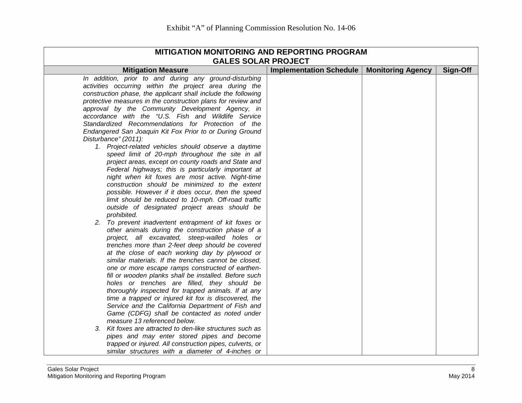
Exhibit “A” of Planning Commission Resolution No. 14-06
Gales Solar Project 8 Mitigation Monitoring and Reporting Program May 2014
MITIGATION MONITORING AND REPORTING PROGRAM GALES SOLAR PROJECT
Mitigation Measure Implementation Schedule Monitoring Agency Sign-Off In addition, prior to and during any ground-disturbing activities occurring within the project area during the construction phase, the applicant shall include the following protective measures in the construction plans for review and approval by the Community Development Agency, in accordance with the “U.S. Fish and Wildlife Service Standardized Recommendations for Protection of the Endangered San Joaquin Kit Fox Prior to or During Ground Disturbance” (2011):
1. Project-related vehicles should observe a daytime speed limit of 20-mph throughout the site in all project areas, except on county roads and State and Federal highways; this is particularly important at night when kit foxes are most active. Night-time construction should be minimized to the extent possible. However if it does occur, then the speed limit should be reduced to 10-mph. Off-road traffic outside of designated project areas should be prohibited.
2. To prevent inadvertent entrapment of kit foxes or other animals during the construction phase of a project, all excavated, steep-walled holes or trenches more than 2-feet deep should be covered at the close of each working day by plywood or similar materials. If the trenches cannot be closed, one or more escape ramps constructed of earthen-fill or wooden planks shall be installed. Before such holes or trenches are filled, they should be thoroughly inspected for trapped animals. If at any time a trapped or injured kit fox is discovered, the Service and the California Department of Fish and Game (CDFG) shall be contacted as noted under measure 13 referenced below.
3. Kit foxes are attracted to den-like structures such as pipes and may enter stored pipes and become trapped or injured. All construction pipes, culverts, or similar structures with a diameter of 4-inches or

Exhibit “A” of Planning Commission Resolution No. 14-06
Gales Solar Project 9 Mitigation Monitoring and Reporting Program May 2014
MITIGATION MONITORING AND REPORTING PROGRAM GALES SOLAR PROJECT
Mitigation Measure Implementation Schedule Monitoring Agency Sign-Off greater that are stored at a construction site for one or more overnight periods should be thoroughly inspected for kit foxes before the pipe is subsequently buried, capped, or otherwise used or moved in any way. If a kit fox is discovered inside a pipe, that section of pipe should not be moved until the Service has been consulted. If necessary, and under the direct supervision of the biologist, the pipe may be moved only once to remove it from the path of construction activity, until the fox has escaped.
4. All food-related trash items such as wrappers, cans, bottles, and food scraps should be disposed of in securely closed containers and removed at least once a week from a construction or project site.
5. No firearms shall be allowed on the project site. 6. No pets, such as dogs or cats, should be permitted
on the project site to prevent harassment, mortality of kit foxes, or destruction of dens.
7. Use of rodenticides and herbicides in project areas should be restricted. This is necessary to prevent primary or secondary poisoning of kit foxes and the depletion of prey populations on which they depend. All uses of such compounds should observe label and other restrictions mandated by the U.S. Environmental Protection Agency, California Department of Food and Agriculture, and other State and Federal legislation, as well as additional project-related restrictions deemed necessary by the Service. If rodent control must be conducted, zinc phosphide should be used because of a proven lower risk to kit fox.
8. A representative shall be appointed by the project proponent who will be the contact source for any employee or contractor who might inadvertently kill or injure a kit fox or who finds a dead, injured or entrapped kit fox. The representative will be identified during the employee education program

Exhibit “A” of Planning Commission Resolution No. 14-06
Gales Solar Project 10 Mitigation Monitoring and Reporting Program May 2014
MITIGATION MONITORING AND REPORTING PROGRAM GALES SOLAR PROJECT
Mitigation Measure Implementation Schedule Monitoring Agency Sign-Off and their name and telephone number shall be provided to the Service.
9. An employee education program should be conducted for any project that has anticipated impacts to kit fox or other endangered species. The program should consist of a brief presentation by persons knowledgeable in kit fox biology and legislative protection to explain endangered species concerns to contractors, their employees, and military and/or agency personnel involved in the project. The program should include the following: A description of the San Joaquin kit fox and its habitat needs; a report of the occurrence of kit fox in the project area; an explanation of the status of the species and its protection under the Endangered Species Act; and a list of measures being taken to reduce impacts to the species during project construction and implementation. A fact sheet conveying this information should be prepared for distribution to the previously referenced people and anyone else who may enter the project site.
10. Upon completion of the project, all areas subject to temporary ground disturbances, including storage and staging areas, temporary roads, pipeline corridors, etc. should be re-contoured if necessary, and revegetated to promote restoration of the area to pre-project conditions. An area subject to "temporary" disturbance means any area that is disturbed during the project, but after project completion will not be subject to further disturbance and has the potential to be revegetated. Appropriate methods and plant species used to revegetate such areas should be determined on a site-specific basis in consultation with the Service, California Department of Fish and Game (CDFG), and revegetation experts.
11. In the case of trapped animals, escape ramps or

Exhibit “A” of Planning Commission Resolution No. 14-06
Gales Solar Project 11 Mitigation Monitoring and Reporting Program May 2014
MITIGATION MONITORING AND REPORTING PROGRAM GALES SOLAR PROJECT
Mitigation Measure Implementation Schedule Monitoring Agency Sign-Off structures should be installed immediately to allow the animal(s) to escape, or the Service should be contacted for guidance.
12. Any contractor, employee, or military or agency personnel who are responsible for inadvertently killing or injuring a San Joaquin kit fox shall immediately report the incident to their representative. This representative shall contact the CDFG immediately in the case of a dead, injured or entrapped kit fox. The CDFG contact for immediate assistance is State Dispatch at (916)445-0045. They will contact the local warden or Mr. Paul Hoffman, the wildlife biologist, at (530)934-9309. The Service should be contacted at the numbers below.
13. The Sacramento Fish and Wildlife Office and CDFG shall be notified in writing within three working days of the accidental death or injury to a San Joaquin kit fox during project related activities. Notification must include the date, time, and location of the incident or of the finding of a dead or injured animal and any other pertinent information. The Service contact is the Chief of the Division of Endangered Species, at the addresses and telephone numbers below. The CDFG contact is Mr. Paul Hoffman at 1701 Nimbus Road, Suite A, Rancho Cordova, California 95670, (530) 934-9309.
14. New sightings of kit fox shall be reported to the California Natural Diversity Database (CNDDB). A copy of the reporting form and a topographic map clearly marked with the location of where the kit fox was observed should also be provided to the Service at the address below.
IV-2. The project security fence shall have a continuous 5-inch opening between the fence mesh and the ground, or the fence shall be raised 5 inches above the ground, to allow possible passage for kit fox and smaller fauna. The bottom of
Prior to the approval of the Improvement Plans, the fence design details identified in this mitigation measure shall be
Community Development Agency

Exhibit “A” of Planning Commission Resolution No. 14-06
Gales Solar Project 12 Mitigation Monitoring and Reporting Program May 2014
MITIGATION MONITORING AND REPORTING PROGRAM GALES SOLAR PROJECT
Mitigation Measure Implementation Schedule Monitoring Agency Sign-Off the fence fabric shall be knuckled (wrapped back to form a smooth edge) to protect wildlife that passes under the fence. The design details shall be reflected on the Improvement Plans for the project, prior to their approval by the Community Development Agency.
included on the plans.
V-1. Should previously unidentified cultural resources be discovered during construction of the project, the project sponsor shall cease work within 100 feet of the resources, and Kings County Community Development Agency shall be notified immediately. The project proponent shall retain a professional archaeologist to assess the significance of the find and make mitigation recommendations, if warranted. The archaeologist shall document the resources using DPR 523 forms and file said forms with the California Historical Resources Information System (CHRIS). The Resources shall be photo-documented and collected by the archaeologist for submittal to the Santa Rosa Rancheria’s Cultural and Historical Preservation Department. The archaeologist shall be required to submit to the County for review and approval a report of the findings and method of curation or protection of the resources. Further grading or site work within the area of discovery shall not be allowed until the preceding steps have been taken.
If previously unidentified cultural resources are found at any time during construction
Community Development Agency
V-2. Pursuant to State Health and Safety Code §7050.5 (c) State Public Resources Code §5097.98, if human bone or bone of unknown origin is found at any time during on- or off-site construction, all work shall stop in the vicinity of the find and the Kings County Coroner shall be contacted immediately. If the remains are determined to be Native American, the coroner shall notify the Native American Heritage Commission who shall notify the person believed to be the most likely descendant. The most likely descendant shall work with the applicant to develop a program for re-internment of the human remains and any associated artifacts. Additional work cannot take place within the immediate vicinity of the find until the identified appropriate
If human bone or bone of unknown origin is found at any time during construction
Community Development Agency Kings County Coroner

Exhibit “A” of Planning Commission Resolution No. 14-06
Gales Solar Project 13 Mitigation Monitoring and Reporting Program May 2014
MITIGATION MONITORING AND REPORTING PROGRAM GALES SOLAR PROJECT
Mitigation Measure Implementation Schedule Monitoring Agency Sign-Off actions have been implemented.
XII-1. During construction, the applicant shall meet the County’s 75 dB (Lmax) Non-Transportation Noise Standard for residential uses by either (1) using smaller, quieter equipment near residences, (2) buffering the noise by use of temporary sound shields between residences and construction operations involving scrapers and ramming machines, or (3) scheduling construction when the residences are not occupied. Temporary sound shields shall consist of appropriately rated acoustical walls, sufficient to reduce daytime construction noise levels equal to or below 75 dB (Lmax) at the nearest residences to the west and north. For example, STC-25 rated temporary sound panels can reduce construction noise by approximately 15-20 dBA, resulting in construction noise levels up to 73 dB (Lmax) at the nearest residence, which is below the County’s non-transportation noise standard for the daytime period. The barriers shall be placed to break the line of sight from the noise source and the nearest residences. Final noise barrier design shall be reviewed and approved by the County Community Development Agency prior to initiation of construction activities.
Prior to initiation of construction activities, final temporary noise barrier design shall be approved During construction
Community Development Agency