kinematic constraints on mantle-lithosphere...
TRANSCRIPT

COSTECH Project Report - April 2, 2008
Kinematic constraints on mantle-lithosphere interactionsin East Africa
Prof. Eric CalaisPurdue University, Dept. of Earth and Atmospheric Sciences, West Lafayette, U.S.A.
In collaboration with:
Dr. Martine HagaiGeomatics Department, Ardhi University, Dpt. of Geomatics, Dar Es Salaam
Mr. John MsemwaTanzania Survey and Mapping Department, Dar Es Salaam
Prof. Evelyne Mbede and Dr. Richard FerdinandDepartment of Geology, University of Dar Es Salaam
Prof. Cynthia EbingerUniversity of Rochester, Rochester, NY, USA
Prof. Jacques DeverchereUniversity of Brest, France
Dr. Damien DelvauxRoyal Museum for Central Africa, Tervuren, Belgium
1 Background
This work aims at improving our understanding of the dynamics of continental rifting with aparticular emphasis on the role of viscous coupling between asthenospheric flow and lithosphericdeformation. Sparse GPS and earthquake skip vector data in the East African Rift (EAR),coupled with recent tomographic images of sub-lithospheric structures and seismic anisotropydata, suggest that mantle flow, possibly associated with the African Superplume, interacts withthe 200 km-thick lithospheric keel of the Tanzanian craton, driving lithospheric motions andcontinental rifting in eastern Africa.
The proposed work is testing this hypothesis by (1) establishing the kinematics of the EARusing GPS measurements at new and existing sites in Tanzania, (2) assessing asthenosphericflow from an inversion of GPS velocities and seismic anisotropy data and from plume-lithosphereinteractions models, (3) using the modeled and “estimated” flow as boundary conditions to a 3Dfinite element model of asthenosphere-lithosphere interactions.
This work will address some of the fundamental questions of continental plate tectonics: Areextensional strains broadly distributed or initially localised to narrow zones? Do interactionsbetween mantle flow fields and cratonic keels influence the localisation and orientation of strainwithin continental plates? In addition to these global tectonic issues, this work will answer thefollowing questions specific to East Africa: What is the origin of the magma-poor Western rift
1

system? What are the kinematics of linkage between the Western and Eastern rift systems?
2 Objectives
Figure 1: Location of the study area and regional platetectonic context. Red arrows show GPS velocities atcontinuous GPS stations with respect to Nubia. Solidblack lines show major plate boundaries and activefaults.
In a first step, we will quantify present-day strain distribution across and along theEAR, with a particular emphasis on Tan-zania, that samples both the western andeastern braches of the rift. To do so, weare using Global Positioning System (GPS)data, that will provide crustal displacementswith an accuracy close to 1 mm/yr (hori-zontally). Existing continuous GPS stationson stable Nubia and on the Somalian plate,complemented by additional campaign mea-surements on both plates as planned here,will provide the far-field kinematics. NewGPS measurements spanning the Westernand Eastern rifts in Tanzania, combined withthe distant data on the surrounding plates,will provide the kinematics of deformationacross and along the length of the EAR. GPSmeasurements will also provide strain dis-tribution across and along the Western andEastern rifts. In addition to horizontal mo-tions, GPS measurements will provide verti-cal displacements, critical to test for present-day uplift of the African plateau predictedfrom the African Superplume upwelling.
In a second step, we will use modeling tech-niques to try to understand the observed deformation patterns throughout the lithosphere andupper asthenosphere. A first approach involves the inversion of surface and mantle velocity fieldsto find the best-fitting mantle flow field, independent from deep seismic constraints on the dis-tribution of low velocity zones in the mantle. A second approach involves forward modelling ofplume-lithosphere interactions with a laterally heterogeneous, moving plate lid.
3 Field Activities
3.1 The August 2006 GPS campaign
The 2006 GPS campaign in Tanzania is the first in a series of 3 campaigns aimed at quantifyingthe present-day kinematics of the East African Rift (Figure 2). Achievements of the August 2006GPS field work include:
• Installation and survey of 34 campaign GPS sites across Tanzania to quantify the kinematicsof the East African Rift and to serve as the new Tanzanian first order geodetic network.
2
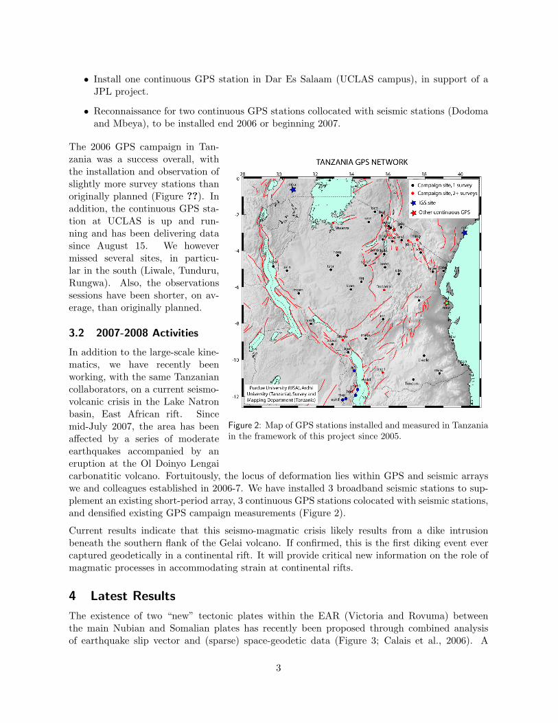
• Install one continuous GPS station in Dar Es Salaam (UCLAS campus), in support of aJPL project.
• Reconnaissance for two continuous GPS stations collocated with seismic stations (Dodomaand Mbeya), to be installed end 2006 or beginning 2007.
Figure 2: Map of GPS stations installed and measured in Tanzaniain the framework of this project since 2005.
The 2006 GPS campaign in Tan-zania was a success overall, withthe installation and observation ofslightly more survey stations thanoriginally planned (Figure ??). Inaddition, the continuous GPS sta-tion at UCLAS is up and run-ning and has been delivering datasince August 15. We howevermissed several sites, in particu-lar in the south (Liwale, Tunduru,Rungwa). Also, the observationssessions have been shorter, on av-erage, than originally planned.
3.2 2007-2008 Activities
In addition to the large-scale kine-matics, we have recently beenworking, with the same Tanzaniancollaborators, on a current seismo-volcanic crisis in the Lake Natronbasin, East African rift. Sincemid-July 2007, the area has beenaffected by a series of moderateearthquakes accompanied by aneruption at the Ol Doinyo Lengaicarbonatitic volcano. Fortuitously, the locus of deformation lies within GPS and seismic arrayswe and colleagues established in 2006-7. We have installed 3 broadband seismic stations to sup-plement an existing short-period array, 3 continuous GPS stations colocated with seismic stations,and densified existing GPS campaign measurements (Figure 2).
Current results indicate that this seismo-magmatic crisis likely results from a dike intrusionbeneath the southern flank of the Gelai volcano. If confirmed, this is the first diking event evercaptured geodetically in a continental rift. It will provide critical new information on the role ofmagmatic processes in accommodating strain at continental rifts.
4 Latest Results
The existence of two “new” tectonic plates within the EAR (Victoria and Rovuma) betweenthe main Nubian and Somalian plates has recently been proposed through combined analysisof earthquake slip vector and (sparse) space-geodetic data (Figure 3; Calais et al., 2006). A
3

third, dominantly oceanic Lwandle plate was recently postulated by a re-analysis of the post3.2 Ma spreading rates and transform-fault azimuths along the Southwest Indian Ridge (SWIR;Horner-Johnson et al., 2007).
Figure 3: Best-fit kinematic model. Relative motionsalong plate or block boundaries are shown with blackarrows, numbers are model velocities in mm.yr−1.Relative rotation poles are shown with black stars.The first plate rotates counter-clockwise with respectto the second, except for VI-NU where Victoria ro-tates clockwise with respect to Nubia.
We have used an updated geodetic solution –a combination of all continuous GPS stationson the Nubia, Somalia, and Antarctic plates,campaign GPS measurements in Africa, and aglobal DORIS solution – together with earth-quake slip vectors in the EAR and transformazimuth and spreading rates along the SWIR.We show that the space geodetic data and the3.2 Ma average oceanic data along the SWIRare consistent with each other at the 95% con-fidence level. The data support a kinematicmodel with (1) a present-day Nubia-SomaliaEuler pole located to the SE of the southerntip of Africa, (2) the existence of three distinctmicroplates embedded in the EAR: Victoria,Rovuma, and Lwandle (Figure 3).
The data used so far therefore support a rift-ing model with localized strain along narrowrift structures that isolate large lithosphericblocks. Improved geodetic coverage of Africaand surrounding islands remains however es-sential to test and further refine this kinematicmodel.
5 Future plans
The next step in our field data acquisition willconsist of a new GPS campaign in August 2008to remeasure the network installed and firstsurveyed in August 2006. This will provide uswith a first image of the present-day kinemat-ics and strain distribution between the westernand eastern branches of the EAR.
We are also planning the installation of two continuous GPS stations colocated with AfricaArrayseismic stations at Dodoma and Mbeya.
In addition, we will service the 3 new semi-permanent GPS stations and 3 broadband seismicstations installed in January 2007 in the Natron area to monitor the recent seismo-magmaticcrisis.
4

6 Broader Impacts
Because of its global reach and precision, GPS is the technique of choice for sustainable geodeticoperations worldwide. However, most African countries do not possess a modern, space-based,geodetic network nor have experience or resources to establish a countrywide network. The in-ternational geodetic community is addressing this issue through the African REference Frame(AFREF) initiative (http://w3sli.wcape.gov.za/SURVEYS/MAPPING/afref.htm). AFREF is pro-moting the creation of a uniform coordinate system for Africa by establishing a framework ofpermanent or semi-permanent GPS base stations and tying national geodetic system a common,space-based, reference system. Our project will contribute to AFREF by improving the space-based geodetic infrastructure in Tanzania. The geodetic benchmarks installed and measuredduring the course of the project will become part of Tanzania’s first-order geodetic network.Data from the two continuous GPS stations will be made available to the Tanzanian MappingAuthority for distribution to surveyors.
Many African countries also lack scientists trained in modern space techniques, thereby ensuringreliance on others to take advantage of the new technological and economical openings madeavailable by the GPS technology. Our Tanzanian collaborating institutions have both expresseda very strong interest in training in GPS geodesy, in particular for their students and junior staff.
During the course of the project, collaborators from the Dar Es Salaam University and theTanzanian Mapping Authority are receiving training in GPS by participating in the fieldworkand data analysis. In August 2008, the GAMIT-GLOBK GPS data processing software at thesetwo institutions and organize a training workshop to teach researchers and students how to use it.We will advise our collaborators on their own GPS projects, such as the local-scale GPS networkinitiated in the Rukwa area by the Department of Geology or the first-order GPS network plannedby the Mapping authorities.
7 Publications
Publications in Refereed Papers:
Calais, E., C. Hartnady, C. Ebinger, and J.M. Nocquet, Kinematics of the East African Rift fromGPS and earthquake slip vector data, In: Yirgu, G., Ebinger, C.J. & Maguire, P.K.H. (eds)Structure and Evolution of the Rift Systems within the Afar volcanic province, NortheastAfrica, Geological Society of London Special Publications, 259, p.9-22, 2006.
Stamps, D.S., E. Calais, E. Saria, C. Hartnady, J. Nocquet, C.J. Ebinger, and R.M. Fernandes(2008), A kinematic model for the East African Rift, Geophys. Res. Lett., 35, L05304,doi:10.1029/ 2007GL032781.
Calais, E., N. d’Oreye, J. Albaric, A. Deschamps, D. Delvaux, J. Deverchere, C. Ebinger, R.W.Ferdinand, F. Kervyn, A.S. Macheyeki, A. Oyen, J. Perrot, E. Saria, B. Smets, D.S. Stamps,and C. Wauthier, Aseismic strain accommodation by dyking in a youthful continental rift,East Africa, Nature, submitted, 2008.
Presentations at Meetings:
Saria, E., E. Mbede, D.S. Stamps, S. Hernandez, E. Calais, C. Ebinger, Kinematics of the EastAfrican Rift from GPS and earthquake slip vector data, American Geophysical Union, Fallmeeting, San Francisco, 2006.
5

Stamps, D.S., E. Calais, et al., Kinematics of the East African Rift from GPS and earthquakeslip vector data, International Conference on the East African Rift System – EARS 2007,23-25 JULY 2007, Kampala, Uganda.
Stamps, D.S., E. Calais, et al., Present-day Kinematics of the East African Rift, Eos Trans.AGU, 88(52), Fall Meet. Suppl., 2007.
d’Oreye, N., A. Oyen, C. Wauthier, E. Calais, Valerie Cayol, J. Deverchere, C. Ebinger, R.W.Ferdinand, F. Kervyn, E. Mbede, and E. Sariah, The Lake Natron (Tanzania) July 2007rifting event revealed by InSAR, EAS FRINGE 2007 Workshop, Frascati (Italy), November2007.
8 Acknowledgments
We are grateful to the Tanzanian Civil Aviation Authorities for releasing the 1998 and 2001 GPSdata collected at Tanzanian airports. We thank the Airport Authorities for allowing us to accessairport sites.
6