kenya land governance assessment...
TRANSCRIPT
1 | P a g e
Kenya Land Governance Assessment Report
By
Patricia Kameri-Mbote
Kenya Country Coordinator
27 June 2016
Pub
lic D
iscl
osur
e A
utho
rized
Pub
lic D
iscl
osur
e A
utho
rized
Pub
lic D
iscl
osur
e A
utho
rized
Pub
lic D
iscl
osur
e A
utho
rized
2 | P a g e
TABLE OF CONTENTS
ABBREVIATIONS ....................................................................................................................................... 3
EXECUTIVE SUMMARY ............................................................................................................................. 5
I. INTRODUCTION ............................................................................................................................. 14
II. METHODOLOGY ............................................................................................................................. 15
III. CONTEXT ANALYSIS, TENURE TYPOLOGY, AND INSTITUTIONAL MAPPING .............................. 17
IV. LAND GOVERNANCE ASSESSMENT ............................................................................................ 32
VIII. CONCLUSION AND NEXT STEPS .................................................................................................... 107
IX. SELECT BIBLIOGRAPHY ................................................................................................................... 110
X. ANNEXES .......................................................................................................................................... 112

3 | P a g e
ABBREVIATIONS
CBOs Community Based Organizations
CLMB County Land Management Boards
CS Cabinet Secretary
EI Expert Investigator
EIA Environment Impact Assessment
FAO Food and Agriculture Organisation
GDP Gross Domestic Product
IBEAC Co Imperial British East African Company
ICTA Information and Communication Technology Authority
IFMIS Integrated Financial Management Information System
ISK Institute of Surveyors of Kenya
ISO International Organisation for Standardisation
KENSUP Kenya Slum Upgrading Programme
KFS Kenya Forest Service
KIA Kenya Investment Authority
KISIP Kenya Informal Settlement Improvement Project
KLA Kenya Land Alliance
KLGRP Kenya Local Government Reform Programme
KMA Kenya Maritime Authority
KNSDI Kenya National Spatial Data Infrastructure
KWS Kenya Wildlife Service
LAPSSET Lamu Port–South Sudan and Ethiopia Transport
LBDA Lake Basin Development Authority
LDGI Land and Governance Institute
LGAF Land Governance Assessment Framework

4 | P a g e
LIM Land Information Management
LIMS Lands Information Management Systems Unit
LI Land Information System
LRTU Land Reform Technical Unit
LSK Law Society of Kenya
MoLHUD Ministry of Lands, Housing and Urban Development (Has since been renamed Ministry of Land and Physical Planning)
NACHU National Cooperative Housing Union
NEMA National Environment Management Authority
NGO Non Governmental Organisation
NLC National Land Commission
NSDI National Spatial Data Infrastructure
SEA Strategic Environmental Assessment
SGR Standard Gauge Railway
TARDA Tana and Athi Rivers Development Authority
TDR Traditional dispute resolution
UN United Nations
USD United States Dollar
WRMA Water Resource Management Authority
5 | P a g e
EXECUTIVE SUMMARY The Kenya Land Governance Assessment Framework was conducted in 2014-2015 against the backdrop of a new Constitution, new land laws and new institutions. It takes stock of progress in land reforms and assesses the status of land governance in Kenya. The Assessment covered nine thematic areas, namely: Land tenure recognition; Rights to forest and common lands & rural land use regulations; Urban land use, planning, and development; Public land management; Process and economic benefit of transfer of public land to private use; Public provision of land information; Land valuation and taxation; Dispute resolution; and Institutional arrangements and policies. Looking at various components of Kenya’s land governance framework, the assessment highlights key governance concerns are dealt with. These include technical complexity of land information and management systems; fragmentation of institutions dealing with land along sectoral and land use and lines (agriculture, wildlife, forests, mining, water among others); vested interests that predispose the sector to corruption and with powerful actors opposed to change; failure to align land use to land rights; tenure insecurity and discrimination against women and marginalized groups; and Aligning land reform interventions to local.
The assessment is done using the LGAF process which uses a highly participatory and country-driven process drawing on local expertise and existing evidence. The Country Coordinator is tasked to identify and engage Expert Investigators to prepare background reports for panels corresponding to the nine thematic areas based on a prescribed set of indicators and dimensions. The EI assessment of each dimension; a preliminary ranking; policy recommendations; and identified best practice forms the basis for the panel discussion. The Panel provides an opportunity for a larger group of experts in a particular theme to discuss and agree on a ranking for the country for each dimension.
Coming five years after the promulgation of Kenya’s 2010 Constitution which radically altered the country’s governance system and formed the basis for new laws on land currently being implemented, the framework will help Kenya align the normative provisions with actual practice on the ground. For land policy, practitioners and academics, this is an invaluable opportunity to come together and debate the Kenya land agenda.
The National Land Policy 2009; the Constitution and policy and legal initiatives under them provide the context within which this assessment is carried out. They provide for public; private and community land holding. The informal land and land in the ten mile coastal do not fall squarely within this categorization. 75% of Kenya’s population lives within the medium to high potential (20% of land area) while the rest live in the vast Arid and Semi-Arid Lands (ASALs). The rural-urban balance stands at 78% and 22% respectively. The size, distribution of land and population density varies widely.
There are a number of entities tasked with managing land: the Ministry of Land Housing and Urban Development (MOLHUD); the National Land Commission (NLC); County Governments (County Land Management Boards and Land Control Boards); the
6 | P a g e
Environment and Land Court; public bodies that manage land based resources such as forests, water, lake and river basins; environment and wildlife); Land owners; Professional and Professional organizations; Civil Society; and the Private sector. The assessment concludes that one, there is an existing legal framework for the recognition and protection of rights but the implementation; enforcement and compliance mechanisms are not effective. Two, most of the land is not registered especially in the rural areas; three the absence of a legal framework for the protection of community land rights despite its inclusion in the Constitution and the lapse of the duration provided for its enactment is a major gap in the law. Four, though the rights of women are provided for, their enjoyment is yet to be realized. Five, with regard to forests, common lands and land use regulations, assignment of responsibility for and demarcation of forests is clear but none exists for rangelands, fisheries and wetlands. Six, multiple rights can exist over the same land for sub-surface resources such as minerals, oil and gas, but these are not recognized and their holders face challenges trying to implement them because law decrees minerals wherever found to be public land. In this regard, it is noteworthy that the issue of other rights and uses of land that has minerals is not canvassed in law and an opportunity exists for the development of a new legal framework in the context of the Voluntary Guidelines on the Responsible Governance of Tenure of Land, Fisheries and Forests1. Six, the absence of a national land use policy and the ineffectiveness of the sectoral land use laws have resulted in degradation of rural land. Seven, migration to urban areas has increased over the years resulting in unplanned settlements to meet housing needs of urban dwellers. Many urban dwellers live in informal settlements and there is no policy of providing low cost housing for the poor. The infrastructure in the large cities is inadequate to cater for the population and most urban dwellers have no access to water, sanitation, electricity and reliable road networks. Eight, there are restrictions on the ownership and use of land in urban areas which are not stringently enforced leading to collapse of buildings and building along riparian reserves. Nine, the requirement for counties to develop integrated development plans is an opportunity to remedy the situation where most urban areas operate with no plans or use outdated ones. The development of a national land use plan will complement and make the county plans more effective. . Ten, vertical development of property has been facilitated by the 1987 Sectional Properties’ Act to cater for the growing urban population and under it, many apartment blocks have been developed. Ten, there are vertical and horizontal institutional overlaps between different institutions charged with the management of public land and resources thereon which hinders effectiveness. Examples of these are the much publicized tussle between the NLC and MOLHUD which went up to the Supreme Court for an Advisory Opinion and the contestations between the national and county governments on management of land based resources such as water and minerals. The absence of both a system for
1 http://www.fao.org/docrep/016/i2801e/i2801e.pdf
7 | P a g e
registering public land and a complete record of public land does not help the situation. Not surprisingly a lot o f public land has been illegally and irregularly converted to private use over the years
Eleven, the law has detailed provisions on the conversion of public land to private use for investment and other purposes. Different mechanisms are used to effect such conversion including auctions, tenders, drawing of lots public request for proposals and pubic exchanges of land of equal value. Data on conversions is hard to come by. It is however, instructive to note that the Land Act requires that substantial transactions of conversion from public to private use require the approval of the National and County Assemblies. The Act does not define what constitutes a substantial transaction making this requirement ineffective and leaving room for abuse. NLC is required to keep a record of private land converted to private use but is yet to do so making it difficult to track the transactions and gauge whether the law is effective in streamlining the conversion process. Investors are required to provide business plans as part of the application for land allocation. Such plans should include benefit sharing arrangements where local communities are involved. Benefit sharing regulations are yet to be finalized and there is no monitoring system to ensure that the investment goals are met and the conditions of grant adhered to. A database on land transferred would be useful to track performance. Further there is need to synergise investment laws with other regulations such as those relating to tax and the environment. Twelve, data on land converted from private use to public use through compulsory acquisition processes is scanty and not easily accessible making it difficult to gauge how well the processes are working and whether the land is applied to the destined use. NLC is required to prescribe criteria and guidelines for land acquisition for public purposes but it is yet to finalize the regulations. Thirteen, land information, a critical component of land governance supporting many functions of land management and administration, is largely manual hindering its effectiveness as a governance tool. The assessment identified an urgent need to re-organize, update, authenticate and digitize land information for ease of access and facilitation of the recognition and protection of rights. Cadastral maps and registry records should be made exhaustive by including all restrictions and should be more easily accessible. It is important to note that land information does not operate in isolation and should be integrated with other data relevant to land. To maintain an effective land information system requires a cadre of highly competent staff which the MOLHUD and NLC should hire, retain and equip to perform to the highest standards. Fourteen, while Kenya has two forms of land tax – rates and stamp duty collected by county and national governments respectively -the number of properties taxed is very small indicating that there are problems of tax coverage, assessment, collection and enforcement. Linked to this is the absence of digitized, up to date valuation rolls which means that the tax collected is not synchronized to current land values or uses. . Updated, digitized and properly maintained valuation rolls and minimized opportunities for discretionary exemptions were identified as ways of enhancing the efficiency of land tax collection, stemming corruption and ensuring complete coverage of rateable properties and taxable land transactions. In addition, there is need to ensure standardized valuation to ensure that values returned for properties are not disparate.

8 | P a g e
Fifteen, Kenya has a robust land dispute settlement framework established at independence to handle the incessant disputes that arose over land and revamped by the 2010 Constitution. One of the innovations is the establishment of an Environment and Land Court to handle land disputes and the promotion of traditional dispute resolution mechanisms to handle land disputes. The realization that some aspects of land disputes may be better handled outside the formal court system had influenced the establishment of tribunals to deal with factual matters which would then be factored into the decisions made by the formal courts. This system did not work as parties would use the two systems as parallel rather than complementary to each other. While the Constitution clearly assigns responsibility for dispute resolution and establishes forums there for, the preponderance of land cases demands that more environment and land courts are established and more judges appointed. Further, there is currently an overlap in mandates of the court and the NLC in dispute resolution that needs to be resolved to avoid conflict between the two which would affect the dispute resolution process. Additionally, the assessment found that a framework for traditional dispute resolution of land matters is necessary to guide traditional governance institutions and outline the nature of disputes that are to be handles at that level.
Finally, the Constitution of Kenya 2010 radically altered the institutional framework for land administration by birthing the NLC and Counties as key land governance institutions to complement the MOLHUD that had previously been the key player along with public bodies occupying public land. The entry of the new institutions requires a reconfiguration of the institutional architecture to accommodate the new players as well as to redefine the roles of the previous players. Creative tension necessarily arises in such a process as vertical and horizontal roles are assigned. Some institutions seem to hang loose such as the Land Control Boards while there is a tussle between others for space. This calls for the need to clarify the fate and role of institutions in the new land legislative framework. The link between natural resource management institutions and land institutions especially with regard to renewable resources and resources in the sub-surface also need to be clarified so that there is synergy in the institutional mandates. The performance of the institutions needs to be tracked and monitored to gauge their contribution to the implementation of land policy objectives and targets.
9 | P a g e
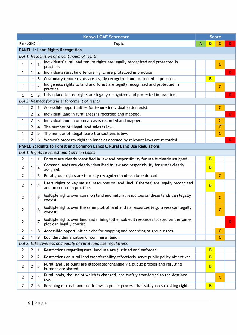
Kenya LGAF Scorecard Score
Pan-LGI-Dim Topic A B C D
PANEL 1: Land Rights Recognition
LGI 1: Recognition of a continuum of rights
1 1 1 Individuals' rural land tenure rights are legally recognized and protected in practice.
C
1 1 2 Individuals rural land tenure rights are protected in practice D
1 1 3 Customary tenure rights are legally recognized and protected in practice. B
1 1 4 Indigenous rights to land and forest are legally recognized and protected in practice.
C
1 1 5 Urban land tenure rights are legally recognized and protected in practice. D
LGI 2: Respect for and enforcement of rights
1 2 1 Accessible opportunities for tenure individualization exist. C
1 2 2 Individual land in rural areas is recorded and mapped. D
1 2 3 Individual land in urban areas is recorded and mapped. C
1 2 4 The number of illegal land sales is low. C
1 2 5 The number of illegal lease transactions is low. C
1 2 6 Women's property rights in lands as accrued by relevant laws are recorded. D
PANEL 2: Rights to Forest and Common Lands & Rural Land Use Regulations
LGI 1: Rights to Forest and Common Lands
2 1 1 Forests are clearly identified in law and responsibility for use is clearly assigned. B
2 1 2 Common lands are clearly identified in law and responsibility for use is clearly assigned.
B
2 1 3 Rural group rights are formally recognized and can be enforced. C
2 1 4 Users' rights to key natural resources on land (incl. fisheries) are legally recognized and protected in practice.
B
2 1 5 Multiple rights over common land and natural resources on these lands can legally coexist.
C
2 1 6 Multiple rights over the same plot of land and its resources (e.g. trees) can legally coexist.
C
2 1 7 Multiple rights over land and mining/other sub-soil resources located on the same plot can legally coexist.
D
2 1 8 Accessible opportunities exist for mapping and recording of group rights. C
2 1 9 Boundary demarcation of communal land. C
LGI 2: Effectiveness and equity of rural land use regulations
2 2 1 Restrictions regarding rural land use are justified and enforced. B
2 2 2 Restrictions on rural land transferability effectively serve public policy objectives. B
2 2 3 Rural land use plans are elaborated/changed via public process and resulting burdens are shared.
B
2 2 4 Rural lands, the use of which is changed, are swiftly transferred to the destined use.
C
2 2 5 Rezoning of rural land use follows a public process that safeguards existing rights. B

10 | P a g e
2 2 6 For protected rural land use (forest, pastures, wetlands, national parks, etc.) plans correspond to actual use.
B
PANEL 3: Urban Land Use, Planning, and Development
LGI 1: Restrictions on Rights
3 1 1 Restrictions on urban land ownership/transfer effectively serve public policy objectives.
C
LGI 2: Transparency of Land Use Restrictions
3 2 1 Process of urban expansion/infrastructure development process is transparent and respects existing rights.
C
3 2 2 Changes in urban land use plans are based on a clear public process and input by all stakeholders.
B
3 2 3 Approved requests for change in urban land use are swiftly followed by development on these parcels of land.
D
LGI 3: Efficiency in the Urban Land Use Planning Process
3 3 1 Policy to ensure delivery of low-cost housing and services exists and is progressively implemented.
D
3 3 2 Land use planning effectively guides urban spatial expansion in the largest city. B
3 3 3 Land use planning effectively guides urban development in the four next largest cities.
B
3 3 4 Planning processes are able to cope with urban growth. C
LGI 4: Speed and Predictability of Enforcement of Restricted Land Uses
3 4 1 Provisions for residential building permits are appropriate, affordable and complied with.
B
3 4 2 A building permit for a residential dwelling can be obtained quickly and at a low cost.
B
LGI 5: Tenure regularization schemes in urban areas
3 5 1 Formalization of urban residential housing is feasible and affordable. C
3 5 2 In cities with informal tenure, a viable strategy exists for tenure security, infrastructure, and housing.
B
3 5 3 A condominium regime allows effective management and recording of urban property.
A
PANEL 4: Public Land Management
LGI 1: Identification of Public Land and Clear Management
4 1 1 Criteria for public land ownership are clearly defined and assigned to the right level of government.
B
4 1 2 There is a complete recording of public land. C
4 1 3 Information on public land is publicly accessible. C
4 1 4 The management responsibility for different types of public land is unambiguously assigned.
B
4 1 5 Responsible public institutions have sufficient resources for their land management responsibilities.
D
4 1 6 All essential information on public land allocations to private interests is publicly accessible.
C
11 | P a g e
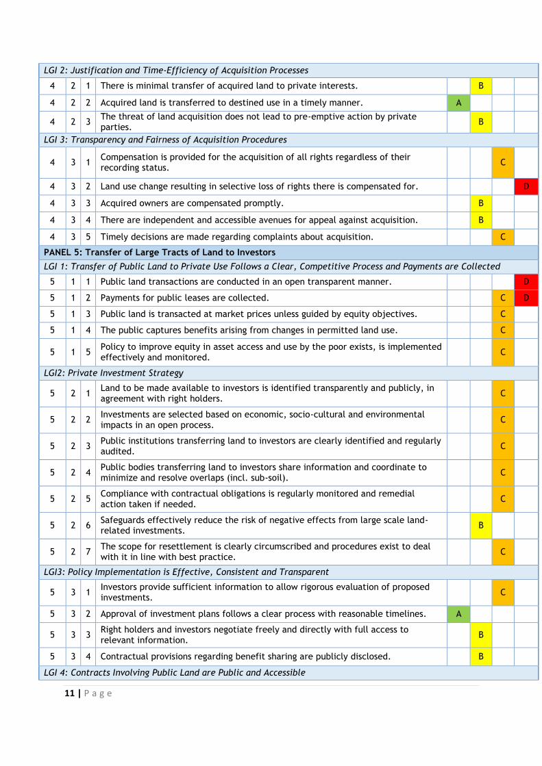
LGI 2: Justification and Time-Efficiency of Acquisition Processes
4 2 1 There is minimal transfer of acquired land to private interests. B
4 2 2 Acquired land is transferred to destined use in a timely manner. A
4 2 3 The threat of land acquisition does not lead to pre-emptive action by private parties.
B
LGI 3: Transparency and Fairness of Acquisition Procedures
4 3 1 Compensation is provided for the acquisition of all rights regardless of their recording status.
C
4 3 2 Land use change resulting in selective loss of rights there is compensated for. D
4 3 3 Acquired owners are compensated promptly. B
4 3 4 There are independent and accessible avenues for appeal against acquisition. B
4 3 5 Timely decisions are made regarding complaints about acquisition. C
PANEL 5: Transfer of Large Tracts of Land to Investors
LGI 1: Transfer of Public Land to Private Use Follows a Clear, Competitive Process and Payments are Collected
5 1 1 Public land transactions are conducted in an open transparent manner. D
5 1 2 Payments for public leases are collected. C D
5 1 3 Public land is transacted at market prices unless guided by equity objectives. C
5 1 4 The public captures benefits arising from changes in permitted land use. C
5 1 5 Policy to improve equity in asset access and use by the poor exists, is implemented effectively and monitored.
C
LGI2: Private Investment Strategy
5 2 1 Land to be made available to investors is identified transparently and publicly, in agreement with right holders.
C
5 2 2 Investments are selected based on economic, socio-cultural and environmental impacts in an open process.
C
5 2 3 Public institutions transferring land to investors are clearly identified and regularly audited.
C
5 2 4 Public bodies transferring land to investors share information and coordinate to minimize and resolve overlaps (incl. sub-soil).
C
5 2 5 Compliance with contractual obligations is regularly monitored and remedial action taken if needed.
C
5 2 6 Safeguards effectively reduce the risk of negative effects from large scale land-related investments.
B
5 2 7 The scope for resettlement is clearly circumscribed and procedures exist to deal with it in line with best practice.
C
LGI3: Policy Implementation is Effective, Consistent and Transparent
5 3 1 Investors provide sufficient information to allow rigorous evaluation of proposed investments.
C
5 3 2 Approval of investment plans follows a clear process with reasonable timelines. A
5 3 3 Right holders and investors negotiate freely and directly with full access to relevant information.
B
5 3 4 Contractual provisions regarding benefit sharing are publicly disclosed. B
LGI 4: Contracts Involving Public Land are Public and Accessible

12 | P a g e
5 4 1 Information on spatial extent and duration of approved concessions is publicly available.
C
5 4 2 Compliance with safeguards on concessions is monitored and enforced effectively and consistently.
C
5 4 3 Avenues to deal with non-compliance exist and obtain timely and fair decisions. C
PANEL 6: Public Provision of Land Information: Registry and Cadastre
LGI 1: Mechanisms for Recognition of Rights
6 1 1 Land possession by the poor can be formalized in line with local norms in an efficient and transparent process.
B
6 1 2 Non-documentary evidence is effectively used to help establish rights. C
6 1 3 Long-term unchallenged possession is formally recognized. B
6 1 4 First-time recording of rights on demand includes proper safeguards and access is not restricted by high fees.
C
6 1 5 First-time registration does not entail significant informal fees. C
LGI 2: Completeness of the Land Registry
6 2 1 Total cost of recording a property transfer is low. C
6 2 2 Information held in records is linked to maps that reflect current reality. B
6 2 3 All relevant private encumbrances are recorded. C
6 2 4 All relevant public restrictions or charges are recorded. C
6 2 5 There is a timely response to requests for accessing registry records. C
6 2 6 The registry is searchable. C
6 2 7 Land information records are easily accessed. B
LGI 3: Reliability of Registry Information
6 3 1 Information in public registries is synchronized to ensure integrity of rights and reduce transaction cost.
6 3 2 Registry information is up-to-date and reflects ground reality.
LGI 4: Cost-effectiveness and Sustainability of Land Administration Services
6 4 1 The registry is financially sustainable through fee collection to finance its operations.
C
6 4 2 Investment in land administration is sufficient to cope with demand for high quality services.
C
LGI 5: Fees are Determined Transparently
6 5 1 Fees have a clear rationale, their schedule is public, and all payments are accounted for.
C
6 5 2 Informal payments are discouraged. D
6 5 3 Service standards are published and regularly monitored. B
PANEL 7: Land Valuation and Taxation
LGI 1: Transparency of Valuations
7 1 1 There is a clear process of property valuation. A
7 1 2 Valuation rolls are publicly accessible. B
LGI 2: Collection Efficiency
7 2 1 Exemptions from property taxes payment are justified and transparent. C
7 2 2 All property holders liable to pay property tax are listed on the tax roll. D
7 2 3 Assessed property taxes are collected. C
7 2 4 Receipts from property tax exceed the cost of collection. C
PANEL 8:Dispute Resolution
LGI 1:Assignment of Responsibility
13 | P a g e
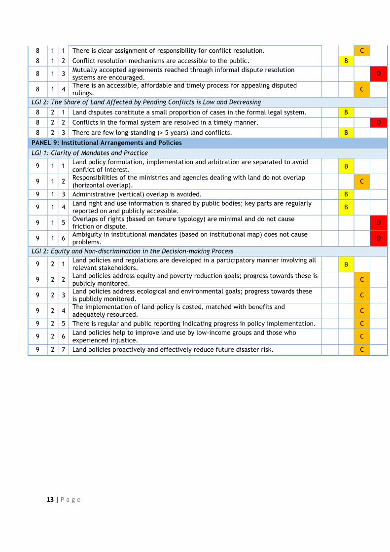
8 1 1 There is clear assignment of responsibility for conflict resolution. C
8 1 2 Conflict resolution mechanisms are accessible to the public. B
8 1 3 Mutually accepted agreements reached through informal dispute resolution systems are encouraged.
D
8 1 4 There is an accessible, affordable and timely process for appealing disputed rulings.
C
LGI 2: The Share of Land Affected by Pending Conflicts is Low and Decreasing
8 2 1 Land disputes constitute a small proportion of cases in the formal legal system. B
8 2 2 Conflicts in the formal system are resolved in a timely manner. D
8 2 3 There are few long-standing (> 5 years) land conflicts. B
PANEL 9: Institutional Arrangements and Policies
LGI 1: Clarity of Mandates and Practice
9 1 1 Land policy formulation, implementation and arbitration are separated to avoid conflict of interest.
B
9 1 2 Responsibilities of the ministries and agencies dealing with land do not overlap (horizontal overlap).
C
9 1 3 Administrative (vertical) overlap is avoided. B
9 1 4 Land right and use information is shared by public bodies; key parts are regularly reported on and publicly accessible.
B
9 1 5 Overlaps of rights (based on tenure typology) are minimal and do not cause friction or dispute.
D
9 1 6 Ambiguity in institutional mandates (based on institutional map) does not cause problems.
D
LGI 2: Equity and Non-discrimination in the Decision-making Process
9 2 1 Land policies and regulations are developed in a participatory manner involving all relevant stakeholders.
B
9 2 2 Land policies address equity and poverty reduction goals; progress towards these is publicly monitored.
C
9 2 3 Land policies address ecological and environmental goals; progress towards these is publicly monitored.
C
9 2 4 The implementation of land policy is costed, matched with benefits and adequately resourced.
C
9 2 5 There is regular and public reporting indicating progress in policy implementation. C
9 2 6 Land policies help to improve land use by low-income groups and those who experienced injustice.
C
9 2 7 Land policies proactively and effectively reduce future disaster risk. C
14 | P a g e
I. INTRODUCTION In Kenya, like in many other African countries, land is an important resource and has
multiple uses. It is a factor of production; has economic functions, and is also essential
for the country’s social, cultural and political development. Despite the importance of
land in Kenya, rights to, management of and the enjoyment and productive use of land
have been the subject of serious contestation over the years. Starting from the
imposition of colonial rule, to the fight for independence, to post-independent Kenya, the
land question has remained a key governance concern for Kenya. Among the key
governance concerns are:
Technical complexity of land information and management systems;
Fragmentation of institutions dealing with land along sectoral and land use and
lines (agriculture, wildlife, forests, mining, water among others)
Vested interests that predispose the sector to corruption and with powerful actors opposed to change;
Failure to align land use to land rights; Tenure insecurity and discrimination against women and marginalized groups;
and Aligning land reform interventions to local circumstances.
In responding to the multiple aspects of the land question, several policy and legal
responses have been formulated by the Kenyan Government. Starting from the 1955Plan
to Intensify the Development of African Agriculture in Kenya (The Swynnerton Plan) and
culminating with the enactment of the National Land Policy in 2009, the Constitution of
Kenya in 2010 and new land laws in 2012. Despite these reforms, there are still
unresolved problems. Implementation of new policies and laws has not been as speedy
and efficient as was hoped and this delays the manifestation of impacts. Institutional
rivalries and duplications continue to manifest, land related conflicts have been reported
in the recent past and insecurity over land rights remain a perennial complaint from the
citizenry. It is against this background that the Land Governance Assessment
Framework (LGAF), a process for systematic assessment of land governance in select
countries was carried out in Kenya. LGAF provides an opportunity for taking stock of
progress in land reforms and assessing the status of land governance in Kenya. Coming
five years after the promulgation of the Constitution and when the country is
implementing the land laws passed under that Constitution, the framework is an
invaluable tool for critically evaluating where we have come from and where we are
going. It will help Kenya align the normative provisions with actual practice on the
ground. This is particularly pertinent as new institutions such as Counties and the
National Land Commission take shape and find their space within a context where the
Ministry of Lands and the national government operated alone.
15 | P a g e
II. METHODOLOGY The LGAF process is a diagnostic instrument that assesses the status of land governance at the
country or sub-national level. It uses a highly participatory and country-driven process drawing
systematically on local expertise and existing evidence rather than on outsiders. At the core of
the implementation of the process is a Country Coordinator who is knowledgeable in land
governance issues and a national of the country being assessed.
The Assessment is undertaken around nine thematic areas, namely:
(1) Land tenure recognition;
(2) Rights to forest and common lands & rural land use regulations;
(3) Urban land use, planning, and development;
(4) Public land management;
(5) Process and economic benefit of transfer of public land to private use;
(6) Public provision of land information;
(7) Land valuation and taxation
(8) Dispute resolution
(9) Institutional arrangements and policies.
It is the responsibility of the Country Coordinator to identify and engage Expert
Investigators to prepare background reports for the panel (s) assigned. More specifically
the Expert Investigator (EI) gathers data required for the assessment based on a
prescribed set of indicators and dimensions from the LGAF. The data is collected from
administrative datasets, as well as legislative, policy, institutional and project report
documents. Some data is also obtained through interviews especially in instances where
secondary information on an issue is dated or not available. From the assessment, the EI
prepares an assessment for each dimension and proposes a preliminary ranking;
deduces policy recommendations for each dimension and; identifies best practice in the
country for the domain.
In Kenya, the group of persons doing work on land is not large and some EIs were
assigned more than one thematic area. The EIs were drawn from academia, civil society
and land professionals who are familiar with the respective dimensions that were being
ranked. Once the reports of the EIs were ready, the CC organized panels to discuss the
reports, discussing each dimension; presenting the EI ranking based on analysis and
giving reasons for their ranking. The members of the panels deliberate and come to

16 | P a g e
consensus on the final country ranking and formulate policy recommendation(s) for
follow up work.
Six expert investigators carried out the assessments in Kenya. (See Annex1) From the
exercise, EIs and panellists agreed that the key themes and panels in the LGAF manual
are applicable to Kenya. Most of the definitions were also in tandem with key definitions
in Kenya’s National Land Policy and the Constitution. They however noted that some
terminologies required critical elucidation within the Kenyan context. These include:
historical injustices; matrimonial property and matrimonial home; the meaning of the
term ‘charge’ to include both mortgages and charges which is a new development in the
new land laws; resource tenure; absentee land owners; and marginalized communities.
These have coloured the discussions in the themes. Further, while easements are
recognized in the Land Act, there is provision for environmental easements in the
Environment Management and Coordination Act and the Wildlife Act 2013 which have
been used to provide wildlife migration corridors. On the other hand, the term
indigenous was found not to be in congruence with the term used in Kenya which is
‘community’.
The panels were held between March and August 2015. The panellists were drawn from
government institutions, academia, civil society and other professionals working on land
issues. While the recommended number of panellists was recommended as between
eight and ten, the panels in Kenya varied in composition from four members to twelve
members. Having many panellists made the discussions very difficult to control but
luckily that was only the case for two panels - Public provision of land information:
registry and cadastre and Land valuation and taxation. Having few panellists could also
lead to skewed discussions. This danger was averted by the fact that the panellists were
drawn from diverse backgrounds – private sector; government; civil society and
academia.
The proceedings of the Panels were recorded in Panel Aide Memoires and the Country
Coordinator worked closely with the panellists to ensure that their views were correctly
captured. The EI reports and the Panel Aide Memoires have largely formed the fodder
for this report. The report also drew from the discussions at regional meeting held in
Ethiopia in December 2014 where all Country Coordinators participated and the
comments given by the members of the Technical Advisory Group to reports of the
experts and the Panel Aide Memoires.
17 | P a g e
III. CONTEXT ANALYSIS, TENURE TYPOLOGY, AND INSTITUTIONAL
MAPPING
A. Context
There is general agreement that land is central to Kenya’s economy and is also a basis of
livelihood for the majority of Kenyans. Land is recognized as being Kenya’s primary
resource and the basis of livelihood for the people that should therefore be held,
used/developed and managed in a manner which is equitable, efficient, productive and
sustainable. Land is a politically sensitive issue and is deemed to be crucial for political
stability, social cohesion, economic development, poverty reduction and good
governance in Kenya. Moreover land issues are complex and dynamic underscoring the
importance of land governance frameworks and the need to establish effective legal,
institutional and administrative procedures to manage land.
There is probably no issue in Kenya that arrests the attention of the people like land.
From the colonial times, the solution to the land issue has proven intractable in law and
policy. Indeed at each juncture of political transitions, land has been a core point of
contention and contestation. Not surprisingly, the land sector in Kenya has gone through
tremendous evolution since the colonial times. It has been the subject of many
commissions of inquiry and public debate. Some of the notable commissions during the
colonial times include the Carter Commission the 1930s that dealt with communities’
allocations and the Swynnerton Plan that introduced the Torrens registration system for
native occupied land in the 1950s. In the post-independence period, land issues have
been addressed in different contexts such as elections; constitutional review and overall
governance. Indeed, the failure to comprehensively deal with the land issue has made it
a convenient space for contestation, which has resulted in violent clashes in different
historical periods. The most notable violence that had the land issue at its core was the
2007-2008 post-election violence in which over 1000 people died.
The first ever National Land Policy was crafted by government with broad participation
of civil society actors and academia and it identified many issues as requiring attention
such as land administration; access to land; land use planning; restitution for historical
injustices; the institutional framework; land information management system;
environmental concerns; conflict/dispute resolution; outdated legal framework; and
unplanned proliferation of informal urban settlements.
These were dealt with under key policy principles namely: equitable access to land;
intra- and inter- generational equity; gender equity; secure land rights; effective
regulation of land development; sustainable land use; access to land information;
18 | P a g e
efficient land management; vibrant land markets; and transparent and good democratic
governance of land. These principles broadly iterate with the LGAF themes (Recognition
and respect for existing rights (legal and institutional framework); Land Use Planning,
Management and Taxation; Management of Public Land; Public Provision of Land
Information; Dispute Resolution and Conflict Management).
Notable sources of land sector reform issues and proposals include the Presidential
Commission of Inquiry into the Land Law System of Kenya, popularly known as the
Njonjo Commission, 2002; Akiwumi Commission, 1997; the Presidential Commission of
Inquiry into the Illegal/Irregular Allocation of Public Land, popularly referred to as the
Ndungu Report, 2004; The Kenya National Dialogue and Reconciliation Process, 2009;
The National Land Policy, Sessional Paper No. 3 of 2009; The Constitution of Kenya
Review process and the resultant Constitution of Kenya 2010; Land laws implementing
the Constitution (Land Act, 2012; Land Registration Act, 2012 National Land
Commission Act, 2012; Devolution Acts, 2012-2013; Draft Community Land Bill, 2013;
Draft Evictions Bill, 2013; and the Environment and Land Act, 2012; Vision 2030; the
Environment Management and Coordination Act, 2000 (currently under revision); and
the draft National Land Use Planning Policy. Other notable actions include the
establishment of the National Land Commission; the enhancement of the Ministry of
Lands structure to include the Land Reform Technical Unit (LRTU), the Lands
Information Management Systems Unit (NLIMS), and the National Titling Centre.
The Constitution of Kenya 2010, promulgated after the National Land Policy, addresses
the issue of land holistically dealing with tenure, land use planning and sustainability
and dispute resolution. It includes many tenets in the Policy. This is a radical departure
from the repealed Constitution. The Constitution’s Article 60 has a more clarified list of
land policy principles which include equitable access to land; security of land rights;
sustainable and productive management of land rights; transparent and cost effective
administration of land; sound conservation and protection of ecologically sensitive
areas; elimination of gender discrimination in law, customs and practices related to land
and property in land;; and encouragement of communities to settle land disputes
through recognized local community initiatives consistent with the constitution. On
dispute resolution, it is worth noting that while an Environment and Land Court was
established to complement other formal dispute resolution mechanisms, the
Constitution recognizes traditional dispute resolution mechanisms adverting to the
plurality of customary legal systems’ tenets and processes.
A notable variance between the Policy and the Constitution is the institutional forms and
the respective mandates. The nature and form of the devolved system of government
was concluded after the Policy was passed making some of the institutions identified in
the Policy redundant.
19 | P a g e
B. Land Tenure Typologies in Kenya
Tenure is derived from the Latin word tenere, which means to hold, connoting the nature of the relationship that exists between individuals in relation to a specified thing. As such, land tenure looks at the various ways in which individuals acquire, hold or own, transfer and transmit land2. Land tenure, therefore, envisages the property rights that the owner of the land may exercise and the conditions that have to be met for the owner to enjoy the land. Any attempt at delineating the various typologies under land tenure will, therefore, encompass answering three major questions: who holds, what interest, over which land.
The National Land Policy defines land tenure as the terms and conditions under which
right to land and land-based resources are acquired, retained, used, disposed of, or
transmitted. The Constitution of Kenya provides for three forms of land tenure, namely:
public land, community land and private land. While the Constitution of Kenya
recognizes three tenure typologies (public; community and private), five land tenure
systems are discernible in Kenya: the Public Tenure, Private Tenure, Customary Tenure,
and two special types of tenure; the Informal Tenure and the Ten-Mile Coastal Strip.
While the customary tenure dominates most of the rural lands in Kenya, the private and
public tenure systems control land in the urban areas. The informal tenure is dominant
in the urban areas as well as in several large scale farms in the country in the form of
squatters. The Ten Mile Coastal Strip is found only in the Coast Province of the country
and has the longest history of all the tenure systems in Kenya.
1. The Public Land Tenure System
According to the National Land Policy, public land comprises all that land that is not
private land or community land, or any other land declared to be public land by an Act of
Parliament. Currently, any surveyed public land is registrable under the Permanent
Secretary for the Ministry for Finance. All public land were originally, administered
under the Crown Lands Ordinance of 1902 and the Government Lands Act Cap 280 of
1915. These lands were vested in the President of the Republic of Kenya who over the
years had powers to allocate or make grants of any estate, interest, or rights, in or over
unalienated government land. However, with the promulgation of the Kenya
Constitution 2012, these powers are now vested in the National Land Commission.
Public land in Kenya includes: forest reserves, water bodies, national parks, townships
and other urban centres, land reserved for government institutions and any other
special category of land that may be acquired by government for public use. Estimates
indicate that 10% of land in Kenya is currently categorized as public tenure.3
Public land tenure is provided for under Article 62 of the Constitution. Public land may
be delineated into two broad categories: the first category vests in and is held by the
county government in trust for the people resident in that county and shall be
2Ogolla B D with Mugabe J. 1996 Land Tenure Systems, In Land We Trust; Initiative Publishers, Nairobi Kenya. 3 Njuguna and Baya [ 2001]
20 | P a g e
administered on their behalf by the National Land Commission. This first category of
land consists of unalienated government land; land held, used or occupied by a State
organ (which is not a national State organ) and where the land is not held by the State
organ as a lessee under a private lease; land in respect of which no individual or
community ownership can be established; and land in respect of which no heir can be
identified. The second category vests in and is held by the National Land Commission in
trust for the people of Kenya and shall be administered on their behalf by the National
Land Commission. Public land tenure is an exercise and core aspect of state sovereignty.
This second category consists of minerals and mineral oils, roads and thoroughfares,
water bodies including rivers and lakes, the territorial sea, the exclusive economic zone,
the sea bed, the continental shelf, all land between the high and low water marks and
any land which is not classified as community or private land.
To secure tenure to public land, the Government has carried out the following actions:
repealed the Government Land Act and established a Land Registration Act which has
taken over all the registration aspects of the GLA; put in place a Land Act that includes
substantive issues on the management and administration of public land; established
the National Land Commission to identify and keep an inventory of all public land and
manage public land on behalf of the national and county governments.
2. The Private Land Tenure System
The private tenure systems in Kenya consist mainly of freeholds and leaseholds. Most of
the land parcels held under freehold comprise former settler occupied areas and areas
where native Kenyans acquired rights through land adjudication and consolidation or
where government land was allocated for private development. At present, freeholds are
found in areas where tenure has been converted from trust land to individual tenure
through the process of land adjudication and consolidation. Pockets of freeholds are also
found in the urban centres in areas which were originally agricultural land but were
eventually subsumed into the towns through urban expansion. In Nairobi for example,
pockets of freehold land are found in areas which were originally owned by the Imperial
British East African Company (the IBEA Co) 4and the Karen Blixen5 land.
Leaseholds are interests in land granted for a specific period of time. In Kenya, leases
may be granted for 30, 33, 50, 99, 999 and 9999 years. The 99 years and 33 years leases
may be granted by the Commissioner of Lands for urban plots. The 30 and 50 year leases
are granted by the County Governments. The 999 year leases were granted to the white
settlers in 1915 under the Government Lands Act. At the moment, 20% of land in Kenya
4 The IBEA Co was a Bombay based Imperial East Africa Company (in India) that was granted a charter by Queen Victoria in 1885 to operate, open, and administer the East African Territory from the coast inland on behalf of the Queen; and Sir William Mackinnon was given the responsibility of managing the company. The IBEACo failed due to poor infrastructure and lack of structured public administration in the region and handed over its operations to the East African Protectorate in 1895 5 Karen Blixen was a Danish Lady (Karen Denisen, also known as Tianne) who married a Swedish Royalty, Baron Gustav von Blixen-Finneke. The couple settled in Nairobi and acquired 6000 acres of land at the foot of Ngong hills, 12 miles South of Nairobi, in what is currently referred to as Karen Estate.
21 | P a g e
is estimated to be under private tenure system.6 The 9999 years leases are found in
parts of the Coast Province, the former white highlands and Nairobi area. These are
special leases that were granted alongside the 999 years leases. The new Constitution
fixes the maximum time for leases in Kenya at 99 years. Consequently, all leases with a
time-frame above 99 years will be reviewed accordingly and fixed at 99 years term.
Only citizens of Kenya may hold freehold titles. Private land is defined under Article 64
of the Constitution and held by individuals and corporate legal entities. It is dealt with
under the Land Act and the Land Registration Act.
3. The Customary Land Tenure System
Customary land tenure which falls under the nomenclature community land tenure is
the system of land holding and land use which derives from the operations of the
traditions and customs of the people affected. Customary law derives from the accepted
practices of the people and the principles underlying such practices. The most important
feature of customary land tenure is the predominance of communal ownership of
whatever rights exist in any land.
In Kenya, this tenure system refers to unsurveyed land owned by different Kenyan
communities under customary laws. Being a diverse country in terms of its ethnic
composition, Kenya has multiple customary tenure systems, which vary mainly due to
different agricultural practices, climatic conditions and cultural practices. The tenure
system is currently governed by the Trust Land Act Cap 288 of 1939.
At present, land under customary tenure occupies approximately 70% of the total area
of the country and most of these lands are gradually being converted to private tenure
through the process of land adjudication. The programme which was initially designed
to take just ten years from 1954, when it was initiated, has adopted a face of
permanency due to the complicated cultures of the local communities, administrative
bureaucracy, and several unresolved land disputes. Customary tenure systems are
generally mixed with other tenure systems in the Group Ranches7, the Trust Lands8 and
the Ten-Mile Coastal Strip. With the promulgation of the new Constitution in Kenya,
customary land tenure is recognized in law for the very first time as community land
which is provided for under Article 63 of the Constitution.
Community land vests in and is held by communities identified on the basis of ethnicity,
culture or similar community of interest. Article 63(2) delineates four broad categories
of land that may be classified as community land. These include: land lawfully registered
in the names of group representatives under the provisions of any law; land lawfully
transferred to a specific community by a process of law; any other land declared to be
6 Njuguna and Baya [ 2001] 7 Group Ranches are as special form of communal tenure established under the Land [Group Representatives] Act Cap. 287 of the Laws of Kenya passed in 1968 and granting rights to a group with common customary rights over a defined piece of land. 8 Governed under the Trust Land Act Cap 288 of the Laws of Kenya
22 | P a g e
community land by an Act of Parliament; and land that is held and used by specific
communities as community forests, grazing areas or shrines, ancestral lands and lands
traditionally occupied by hunter gatherer communities, and land held by a county
government as trust lands, but excluding any public land which vests in and is held by
the county government in trust for the people resident in that county.
The inclusion of the broader genus of community of interest under the Constitutional
definition of community land begs the question whether community of interest is
germane to ethnicity and culture or can exist outside of culture and ethnicity. This is a
question that will hopefully be answered when the draft Community Land Bill is
concluded.
4. The Informal Land Tenure System
Informal land tenure refers to a situation where the actual occupation and use of land is
without much legal basis. Informal land settlements cannot be categorized into any of
the three classifications of land tenure provided for under the Constitution. Under this
arrangement, groups of people occupy public or private land without the permission of
the owner. In Kenya, such situations normally occur in the urban areas where rapid
urbanization outstrips the capacity of the urban management to deliver sufficient and
affordable housing for the population.
The production of low-cost housing affordable to low-income migrants has not kept
pace with the spread of the informal settlements due to (i) high building standards
required by the County Governments, (ii) scarcity of land appropriately zoned for such
development, and (iii) development of housing is biased towards middle and upper
income groups. Available statistics9 indicate that presently, 60% of Nairobi residents
live in the informal settlements. For a long time, the law in Kenya did not recognize the
existence of this tenure. However, since the promulgation of the new constitution,
informal tenure has been recognized in law and the government has put in place
mechanisms for provision of secure tenure for the informal settlements through the
Kenya Informal Settlements Improvement Programme (KISIP).
The National Land Policy noted that informal settlements can be found on all of the
constitutional classifications of land tenure and it puts forth a number of measures
which the government should take in order to deal with such settlements. These
measures include, inter alia, the establishment of a legal framework for eviction based
on internationally acceptable guidelines; facilitate the regularization of existing squatter
settlements found on public and community land for the purposes of upgrading or
development; and the establishment of a legal framework and procedures for
transferring unutilized land and land belonging to absentee land owners to squatters
and people living in informal settlements.
9 National Cooperative Housing Union Ltd (NACHU), An NGO in the Ministry of Housing concerned with the upgrading of the informal settlements in Kenya, 1990

23 | P a g e
Concerning the recognition of informal land tenure, there have been proposals to
recognize informal land tenure as a form of community land. In particular, Syagga10
argues that informal tenure must be recognized in order to address tenure insecurity
which characterizes informal systems of tenure. Some see titling as an important way of
recognizing informal land tenure as it would serves to create security of tenure. Syagga,
for example, argues that the most logical way of issuing titles in informal settlements is
through the creation of Community Land Trusts. In essence, this would require informal
settlements to be categorized under community land tenure and to be registered in
accordance with the relevant statutory law. This is primarily because informal
settlements in Kenya comprise of aspects of both communal and individual use.
Communal in the sense that residents living in informal settlements use the land on
which the settlement exists communally and as a community, and they may enjoy
particular the provision of particular services such as water and electricity communally.
Individual in the sense that individuals and families occupy individual structures where
they may also pay for particular services such as water, electricity, toilets and
bathrooms individually.
5. The Ten-Mile Coastal Strip
The Ten-Mile Coastal Strip in Kenya is a piece of land approximately ten nautical miles
wide from the high water mark of the Indian Ocean. It covers an area of 5,480.44 square
km and is approximately 536 km long, stretching from the mouth of River Umba at the
Kenya-Tanzania border to Kipini at the mouth of River Tana, and the Lamu Archipelago.
The land tenure system in the Ten-Mile Coastal Strip has been dictated by the changing
political circumstances in the area. Under the East African Regulations of 1897, people
living in the Ten-Mile Coastal Strip were issued with certificates of ownership for a term
of 21 years in the form of short-term leases. In 1902, land in the Ten-Mile Coastal strip
was considered as government land, and therefore available for alienation under the
Crown Lands Ordinance. However, without some specific legal process, it was difficult
for the government to separate land available for alienation and private land claimed by
the Arabs.11
A provision for land claims within the Ten-Mile Coastal strip was therefore made
possible in 1908 through the Land Titles Ordinance; which was specifically enacted to
adjudicate the land rights in the area in order to separate private land from crown land.
A land court, consisting of a recorder of titles, a surveyor and administrative officers was
set up to listen to and determine the claims. The duties of the Recorder of Titles included
boundary surveys and the preparation of maps to be attached to the certificate of
10 P. Syagga, "Informal Urban Land Management: Property Rights and Tenure Security in Kenya", [2012] in V. Kreibich and W.H. Olima (eds.), Urban Land Management in Africa, (Spring Centre, University of Dortmund, Germany) pp.117-123; In Vol. 8 Journal of Civil Engineering (March 2003) p13-26.
11 Okoth-Ogendo, H.W.O (1976) "African Land Tenure Reform" in Heyer, JJ Maitha and W. Senga, Agricultural Development in Kenya: An Economic Assessment, Oxford University
24 | P a g e
ownership. The Surveyor and the administrative officers only received the claims. The
process of adjudication was therefore solely left to the Recorder of Titles.12
During the adjudication process, most of the land parcels claimed by the landlords as
private property were actually occupied by the indigenous people. The government is
therefore currently faced with a complicated situation where majority of the indigenous
people in the Ten-Mile Coastal strip do not have secure titles to the land while the
absentee landlords, who hold the titles, are not residing on the parcels but are charging
fees to the occupants on what the indigenous communities consider as their ancestral
land.
C. Land Use
Approximately seventy five per cent (75%) of the country’s population lives within the
medium to high potential (20% of land area) and the rest in the vast Arid and Semi-Arid
Lands (ASALs). The size and distribution of land varies quite widely as does population
density which ranges from as low as 2 persons per sq. km. in the ASALs to a high of over
2000 in parts of Kisii, Vihiga, Kiambu and the Eastern slopes of Mount Kenya. The rural-
urban balance stands at 78% and 22% respectively with the most rapid urban growth
centres still confined to Nairobi, Mombasa, Kisumu, Nakuru, Eldoret, Kakamega and
their satellite extensions. According to the 1999 census, the overall growth rate of
Kenya’s urban population now stands at 6% implying a very rapid rural-urban
migration pattern. This is further reflected in the country’s poverty statistics which
indicate that absolute poverty in the rural and urban areas now stands at 50.1% and
53.1% of the population respectively.
In the rural areas, the high to medium potential zones are dominated by millions of
small farm holdings (3.5 million). In some cases, insecure land-tenure systems have led
to low investment in land improvement and productivity. Many smallholder areas are
suffering continuous fragmentation of holdings into uneconomic sizes, and farms are
getting smaller in the high rainfall areas and in the drier zones. In addition, many large
farms that used to produce seed and breeding stock have been sub-divided and
transferred from state to private ownership. In the ASALs pastoralism is the dominant
land use. However insecurity and the policy of encouraging pastoralists to settle down
have led to the development of farms in some traditionally pastoral areas such as
Turkana and Isiolo.
D. Institutional Map
Under the Constitution and the laws under it, there is an elaborate institutional
framework for land governance that includes:
National Government (The Ministry of Lands, Housing & Urban Development which has
Departments of Physical Planning, Survey and Land Administration (includes land
12 Ibid
25 | P a g e
registration). The Ministry’s structure has been enhanced to include the Land Reform
Technical Unit (LRTU); the National Lands Information Management Systems (NLIMS)
Unit; and the National Titling Centre.
National Land Commission County Governments (County Land Management Boards and Land Control
Boards) Environment and Land Court Land owners Professional and Professional organizations. Civil Society Private sector
26 | P a g e
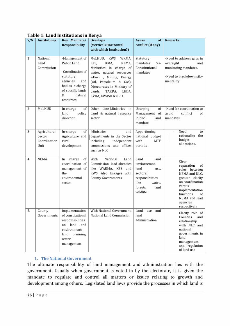
Table 1: Land Institutions in Kenya S/N Institutions Key Mandate/
Responsibility
Overlaps
(Vertical/Horizontal
with which Institution?)
Areas of
conflict (if any)
Remarks
1 National
Land
Commission
-Management of
Public Land
-Coordination of
statutory
agencies and
bodies in charge
of specific lands
& natural
resources
MoLHUD, KWS, WRMA,
KFS, KMA, NEMA,
Ministries in charge of
water, natural resources
&Envi. , Mining, Energy
(Oil, Petroleum & Gas),
Directorates in Ministry of
Lands, TARDA, LBDA,
KVDA, EWASO NYIRO,
Statutory
mandates Vs-
Constitutional
mandates
-Need to address gaps in
oversight and
monitoring mandates.
-Need to breakdown silo-
mentality
2 MoLHUD In-charge of
land policy
direction
Other Line-Ministries in
Land & natural resource
sector
Usurping of
Management of
Public land
mandate
-Need for coordination to
avoid conflict of
mandates
3 Agricultural
Sector
Coordination
Unit
In-charge of
Agriculture and
rural
development
Ministries and
departments in the Sector
including independent
commissions and offices
such as NLC
Apportioning
national budget
with MTF
periods
- Need to rationalize the budget allocations.
4 NEMA In rharge of
coordination of
management of
the
environemtal
sector
With National Land
Commission, lead ahencies
like WARMA, KFS and
KWS. Also linkages with
County Governments
Land and
enviornemnt,
land use,
sectoral
responsibiities
like watre,
forests and
wildlife
Clear separation of roles between NEMA and NLC, greater clarity on coordination versus implementation functions of NEMA and lead agencies respectively
5. County
Governments
implementation
of constitutional
responisbilities
on land and
environment;
land planning,
water
management
With National Government,
National Land Commission
Land use and
land
admnistration
Clarify role of Counties and relationship with NLC and national governments in land management and regulation of land use
1. The National Government
The ultimate responsibility of land management and administration lies with the
government. Usually when government is voted in by the electorate, it is given the
mandate to regulate and control all matters or issues relating to growth and
development among others. Legislated land laws provide the processes in which land is
27 | P a g e
to be dealt with. Processes towards dealing with land are vital and they determine
whether the land resources are suitably, sustainably and effectively used. These are the
major goals of land administration and management.
Globally there are institutional frameworks for tackling issues that regulate land and in
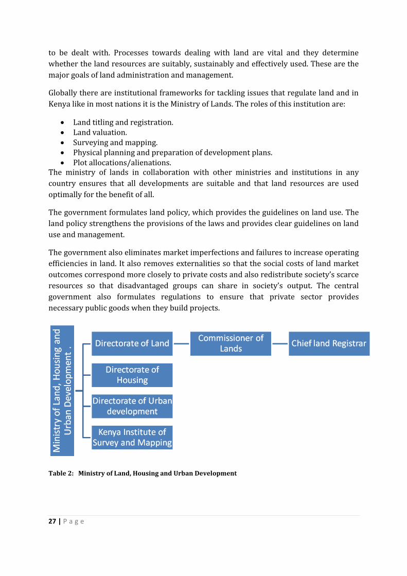
Kenya like in most nations it is the Ministry of Lands. The roles of this institution are:
Land titling and registration. Land valuation. Surveying and mapping. Physical planning and preparation of development plans. Plot allocations/alienations.
The ministry of lands in collaboration with other ministries and institutions in any
country ensures that all developments are suitable and that land resources are used
optimally for the benefit of all.
The government formulates land policy, which provides the guidelines on land use. The
land policy strengthens the provisions of the laws and provides clear guidelines on land
use and management.
The government also eliminates market imperfections and failures to increase operating
efficiencies in land. It also removes externalities so that the social costs of land market
outcomes correspond more closely to private costs and also redistribute society’s scarce
resources so that disadvantaged groups can share in society’s output. The central
government also formulates regulations to ensure that private sector provides
necessary public goods when they build projects.
Table 2: Ministry of Land, Housing and Urban Development
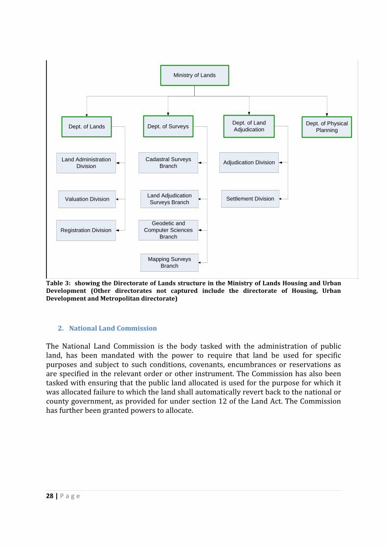
28 | P a g e
Ministry of Lands
Dept. of SurveysDept. of LandsDept. of Land
Adjudication
Adjudication Division
Dept. of Physical
Planning
Settlement Division
Cadastral Surveys
Branch
Land Adjudication
Surveys Branch
Geodetic and
Computer Sciences
Branch
Mapping Surveys
Branch
Land Administration
Division
Valuation Division
Registration Division
Table 3: showing the Directorate of Lands structure in the Ministry of Lands Housing and Urban Development (Other directorates not captured include the directorate of Housing, Urban Development and Metropolitan directorate)
2. National Land Commission
The National Land Commission is the body tasked with the administration of public land, has been mandated with the power to require that land be used for specific purposes and subject to such conditions, covenants, encumbrances or reservations as are specified in the relevant order or other instrument. The Commission has also been tasked with ensuring that the public land allocated is used for the purpose for which it was allocated failure to which the land shall automatically revert back to the national or county government, as provided for under section 12 of the Land Act. The Commission has further been granted powers to allocate.

29 | P a g e
Table 4: National Land Commission
3. County Governments
County Governments operate independently but also under the executive arm of the
central government through the Ministry of Devolution. They serve the role of
decentralizing and devolving land administration and management as they are nearer
the locals than the central government, making land management simple and effective.
They are also responsible for formulating the planning and development frameworks on
which all the decisions on land development should be based. The Physical Planning Act
(1996 revised in 2010) emphasizes the role of County Governments towards land
management.
County Governments globally provide specific public services such as water, electricity,
drainage and sewage but also as defined and stipulated by the Constitution. To put land
into good effect these services are crucial and therefore this qualifies County
Governments to be key stakeholders in land management and administration.
Zoning regulations are the prerogative of the County Governments. These regulations
are vital in land management and administration in that they direct how land can be
used optimally and sustainability. Land management that is effective calls for
participatory approach. County Governments being closer to the public use this aspect
30 | P a g e
to popularize their understanding and have the public mandate to do so all for the
benefit of the area residents.
County Governments under the fiscal ordinances on land taxation also enhance the
productive use of land thus enabling the land owners to pay the land tax and retain some
income for further investments or other uses. Land taxation inform of land rates is a
good tool in enhancing land management and administration.
4. Land Owners
Land owners should ensure that the land is put into the best use as per the land use
regulations in order to have the highest level of returns and satisfy the other land users.
The land use provisions are scattered in different pieces of legislation such as those
dealing with water, agriculture and forests but there is not unified national land use
policy. This results in incongruence between the legal cadastral systems and land use
controls in Kenya on the part of land users. The result has been unplanned development
and general under utilization of land.
5. Professionals and Professional Associations
Professionals such as valuers, conveyancers, lawyers and land surveyors together with their regulating bodies play a critical role in land management and administration process in Kenya. They can complement the public sector which does not have the capacity to carry out and meet the land management and administration process through consultancy services and participation in law crafting, enactment and implementation processes the processes.
Professional bodies help in ensuring the right quality of recruits into the training programs and into the professions. Besides, they set and enforce codes of conduct and standards of practice. The various aspects of land management and administration call for competence so that no loopholes are left for substandard performance. Successful land use planning and zoning calls for use of qualified persons so as to effectively address the fundamental issues regarding to each portion of land.
6. Civil Society
These include Community Based Organizations (CBOs) and Non Governmental Organizations (NGOs). They are regarded as informal gatekeepers though they play critical role in land governance and administration. These local actors regulate land development within their areas and are at the forefront in ensuring that land mismanagement is curtailed. They conduct civic education and enlighten the locals on the importance of good use of land and the governing laws and rules on land use and development. The civil society groups mobilize the locals, and on detection of land misuse and poor development raise public outcry and petition the relevant authorities for redress. In Kenya such associations are vibrant against the misuse of public land manifested through irregular land allocations. They also mobilize the locals to raise funds for their own developments especially low-cost housing. Examples of active civil society organization in the land sector include the Kenya Land Alliance (KLA); Resources Conflict Institute (RECONCILE) and the Land Governance Institute (LDGI). KLA is the

31 | P a g e
oldest one and brings together different groups nationally. It has been very active in the land sector reforms and is effective in getting concerns relating to land heard.
32 | P a g e
IV. LAND GOVERNANCE ASSESSMENT
A. Land Rights Recognition
In Kenya land tenure is defined in the National Land Policy as the terms and conditions
under which rights to land and land-based resources are acquired, retained, used and
disposed of, or transmitted. In terms of tenure security, the law has since the colonial
period recognized individual land holding as the most secure tenure category. Official
policy was consequently geared towards conversion of landholdings from customary
arrangements to private individual land tenure. Secondly starting from the colonial
period, the Crown was vested with ownership of all land resulting in natives then and
later communities, being viewed largely as tenants at the will of the Crown.
A. Recognition of a Continuum of Rights
In the continuum of land rights, individual registered land rights were seen as the most
secure, with the law even holding at some period in history that under the Registered
and Act, a first registration could not be defeated even if it was obtained through fraud.13
Consequently policy and legislative focus was geared towards conversion of all tenure
categories to private tenure. Despite this official policy approach adopted during the
colonial period and continued up to post-independent times, in reality there continued
to exist a diversity of tenure arrangements and a continuum of land rights. To redress
this disjuncture, when the National Land Policy was formulated and adopted it
recognized the plurality of land tenure in Kenya. The Policy provides that:
It adopts a plural approach in which different systems of tenure co-exist and
benefit from equal guarantees of tenure security. The rationale for this plural is
that equal recognition and protection of all modes of tenure will facilitate the
reconciliation and realization of the critical values which land represents.14
Both the National Land Policy and the Constitution recognize three tenure categories of
land, as follows:
Public Land
Community Land
Private Land
In addition to this under the Continuum of tenure rights, one has to address the
following tenure related categories and issues:
customary land tenure
13 Registered Land Act, Cap 300 ( Repealed) 14Republic of Kenya, Session Paper Number 3 of 2009 on National Land Policy, (Government Printer, August 2009), page 11.
33 | P a g e
informal settlements
land rights of spouses and dependents
In discussing land rights in Kenya, the overriding guide of Article 61 of the Constitution15
is instructive. It provides that all land belongs to the people of Kenya. The implications of
this provision is that the tenure classifications of land rights have to be viewed against
the overriding rights of all Kenyans in whom radical title to land vests and on whose
behalf such radical title is to be exercised.
The Constitution clearly recognizes the different tenure categories – Public, Private and
Community. Community Land tenure is particularly relevant for the rights of rural
communities. As a consequence, the greatest groups of people whose land are still
communally held can look forward to constitutional protection. In around 70% of rural
areas, the land is held under customary arrangements. This refers to the tenure regime
in which land is held according to the customs of communities. The essential
characteristic of customary land tenure was that land was held by the community with
members of that community having clearly defined spatial and temporal use rights.
There was also intergenerational transfer of such family rights in accordance with
clearly established rules. In Kenya, since the 1954 Government policy that sought to
promote private tenure in land as the most suitable tenure regime to ensure agricultural
productivity, there has been a systematic effort to eradicate customary tenure in land by
converting it to private tenure regime. Despite this, however, customary land tenure has
remained resilient and is the most widespread and dominant tenure system.16 At
present, land under customary tenure occupies approximately 70% of the total area of
the country and these lands are being converted to private tenure through the process of
land adjudication.17 This tenure category is now recognized under the Constitution.
In addition for those whose land is under private tenure there is legal direction under
the Land Act for the issuance of title deeds within a period of five years. In addition the
Constitution removes protection of private property for properly illegally and
irregularly acquired by stating that the protection for compensation in case of
compulsory acquisition for private land does not extend to land irregularly or illegally
acquired, hence protecting those in rural areas whose land may have been acquired by
unscrupulous people.
15 Republic of Kenya, Constitution of Kenya, 2010 16 See e.g. P. Kameri-Mbote et al, Ours by Right: Laws, Politics and Realities of Community Land Rights in Kenya (Strathmore University Legal Press Nairobi, 2013). 17 Republic of Kenya, 2004 (Statistical Abstract, Nairobi: Bureau of Statistics)
34 | P a g e
B. Respect for and Enforcement of Rights
Although the constitution now recognizes community land tenure, which provides
opportunities for recognition and protection the provision on Community land law is not
being implemented yet due to lack of a community Land law. Land is held under
customary law. In addition some rights like those of women and people living in
informal settlements not fully protected
There is no clear distinction between community land tenure and customary land tenure
despite the fact that in Kenya, customary tenure continues to govern the management
and use of land and land-based resources. Indeed one of the categories of community
land is based on culture. The Constitution provides that community land, or land held
under customary tenure shall be land that is held by communities.18 The basis of
identification for such land holding is ethnicity, culture or related community of
interest.19 Legislation is still required to determine the nature and extent of rights that
one is entitled to under community land and the mode of disposal of such land.20
The use of the ‘rural land tenure’ nomenclature is not common in Kenya but as is clear
from the above paragraph, the Constitution provides for recognition of land under
customary land tenure which would cover rural land tenure. This would include rural
land uses such as pastoralism. While the legal framework for private and public land is
clear in the Land Act, the community land law is yet to be finalised. Certain interests are
also not fully recognized such as the rights of women, rights of indigenous communities
and rights of residents in informal settlements in rural settings.
With regard to indigenous tenure, Kenya has not ratified ILO Convention 169 on
Indigenous and Tribal Peoples. Kenya also abstained from voting on the United Nations
Declaration on the Rights of Indigenous Peoples in 2007. Consequently, while the
Constitution recognizes community land rights, it has taken indigenous communities
like Ogiek and Endorois to litigate both in Kenya and at the African Commission on
Human and People’s Rights for their rights to be acknowledged in practice. Current
efforts through the Task Force on implementation of the Endorois Ruling are still at the
early stages. The controversy around settlement of the Ogiek in the Mau and other
indigenous communities demonstrate the challenges around actual protection of their
rights in practice.
18 The Constitution of Kenya, supra, note 15Article 63(1). 19 Ibid. 20 Ibid. Article 63(4).
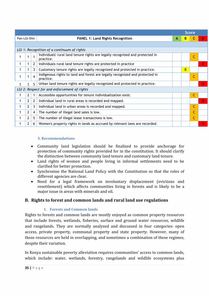
35 | P a g e
Score
Pan-LGI-Dim PANEL 1: Land Rights Recognition A B C D
LGI 1: Recognition of a continuum of rights
1 1 1 Individuals' rural land tenure rights are legally recognized and protected in practice.
C
1 1 2 Individuals rural land tenure rights are protected in practice D
1 1 3 Customary tenure rights are legally recognized and protected in practice. B
1 1 4 Indigenous rights to land and forest are legally recognized and protected in practice.
C
1 1 5 Urban land tenure rights are legally recognized and protected in practice. D
LGI 2: Respect for and enforcement of rights
1 2 1 Accessible opportunities for tenure individualization exist. C
1 2 2 Individual land in rural areas is recorded and mapped. D
1 2 3 Individual land in urban areas is recorded and mapped. C
1 2 4 The number of illegal land sales is low. C
1 2 5 The number of illegal lease transactions is low. C
1 2 6 Women's property rights in lands as accrued by relevant laws are recorded. D
3. Recommendations
Community land legislation should be finalized to provide anchorage for protection of community rights provided for in the constitution. It should clarify the distinction between community land tenure and customary land tenure.
Land rights of women and people living in informal settlements need to be clarified for better protection.
Synchronise the National Land Policy with the Constitution so that the roles of different agencies are clear.
Need for a legal framework on involuntary displacement (evictions and resettlement) which affects communities living in forests and is likely to be a major issue in areas with minerals and oil.
B. Rights to forest and common lands and rural land use regulations
1. Forests and Common lands
Rights to forests and common lands are mostly enjoyed as common property resources
that include forests, wetlands, fisheries, surface and ground water resources, wildlife
and rangelands. They are normally analyzed and discussed in four categories: open
access, private property, communal property and state property. However, many of
these resources are held in overlapping, and sometimes a combination of these regimes,
despite their variation.
In Kenya sustainable poverty alleviation requires communities’ access to common lands,
which include: water, wetlands, forestry, rangelands and wildlife ecosystems plus
36 | P a g e
unregistered community lands essential to rural households for sustainable livelihoods.
The management of these natural resources that are used in common is difficult,
because it requires a balance between individual, community and state interests in those
resources. Indeed the state is constitutionally obligated in Article 69 of the Constitution
of Kenya, 2010 to “ensure sustainable exploitation, utilization, management and
conservation of the environment and natural resources, and ensure the equitable
sharing of the accruing benefits”.
The National Land Policy provides for resource tenure policy by appreciating that
sustainable management of natural resources that include wildlife, forests, water,
marine and land depends on the governance system, which define relationships between
people and natural resources. In the same vein, the draft national land use policy, 2013
urges for a judicious management of natural resources based on the premise that an
equitable and sustainable relationship between human and natural resources is
fundamental and essential for stability and progress of the land sector in a nation’s
development.
Wetlands and coastal marine resources are important to small-scale fishing and farming
rural communities and for food security. Wetlands in Kenya function as primary sources
of livelihood and local economy for many socially and economically excluded groups.
They are however characterized by open access and lack of a unified and appropriate
regulatory framework.21 The result is poor governance of wetland resources manifested
by state appropriation or imposition of private property rights22 leading to
unsustainable utilization or outright conversion of wetlands to other uses.
The need for a better system of resource use governance and empowerment of
vulnerable and marginalized rural communities cannot be gainsaid civil society
organizations have supported the development of new legal frameworks in the context
of the Voluntary Guidelines on the Responsible Governance of Tenure of Land, Fisheries
and Forests.
Rangelands have low rainfall and are in north-central and south rift valley and north-
eastern parts of Kenya. They are characterised as arid, semi-arid and very arid areas and
face environmental problems, such as global warming, land degradation, climate change
and loss of biodiversity. Good governance can facilitate sustainable rangeland
development and complement traditional pastoralists’ adaptation to rangeland
ecosystem change and the resultant reduction of such lands.
Forestland has also been decreasing in Kenya and estimates place forest cover at below
10 per cent of the total land mass of 582,646 square kilometres with some estimates as
low as 1.2 per cent. According to Alden Wily and Mbaya (2001), forests typology found
21 Forest Act, 2005; Environmental Management and Coordination Act, 1999; Wildlife Conservation and Management Act, 2014; Water Act, 2002 among others 22 Yala wetland measuring 19,500 hectares, Tana Delta measuring 28, 400 hectares
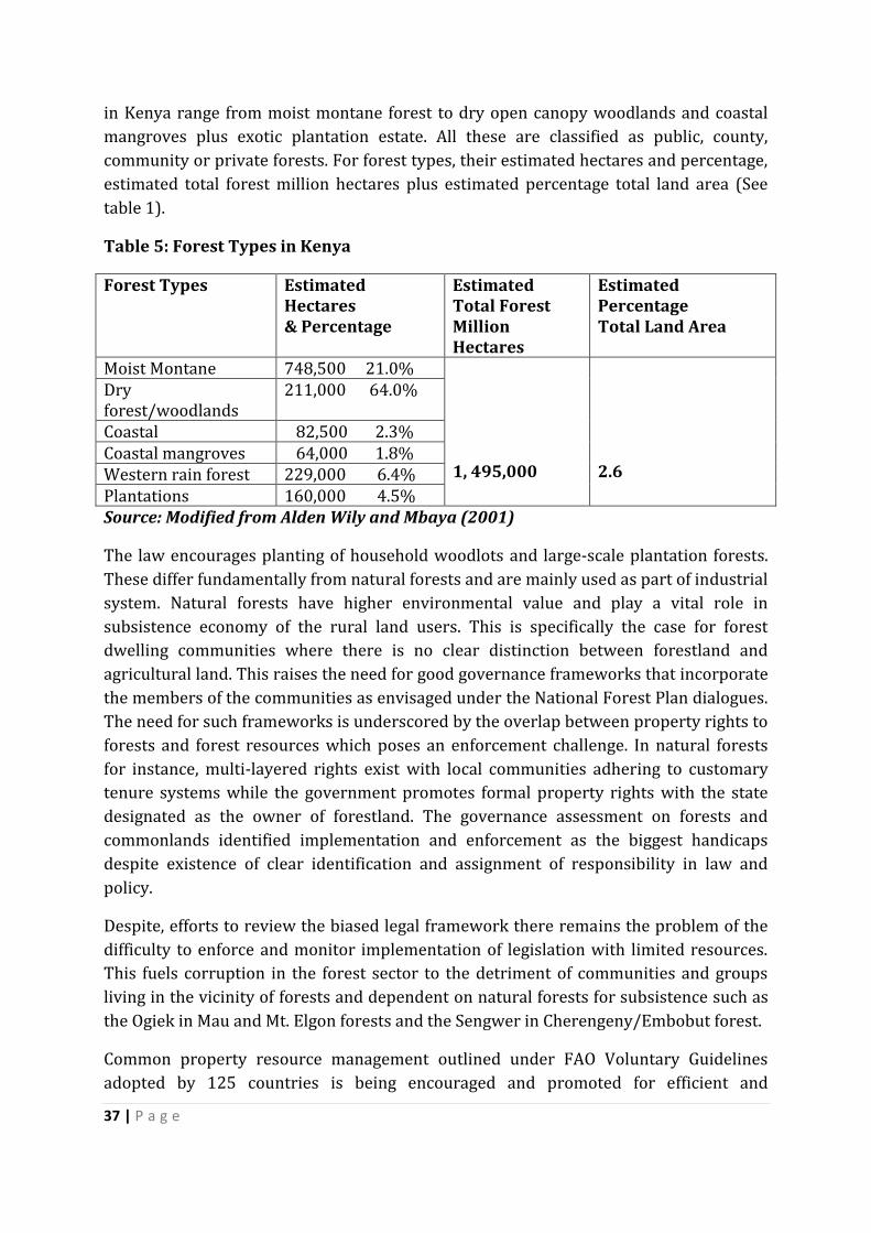
37 | P a g e
in Kenya range from moist montane forest to dry open canopy woodlands and coastal
mangroves plus exotic plantation estate. All these are classified as public, county,
community or private forests. For forest types, their estimated hectares and percentage,
estimated total forest million hectares plus estimated percentage total land area (See
table 1).
Table 5: Forest Types in Kenya
Forest Types Estimated Hectares & Percentage
Estimated Total Forest Million Hectares
Estimated Percentage Total Land Area
Moist Montane 748,500 21.0% 1, 495,000
2.6
Dry forest/woodlands
211,000 64.0%
Coastal 82,500 2.3% Coastal mangroves 64,000 1.8% Western rain forest 229,000 6.4% Plantations 160,000 4.5% Source: Modified from Alden Wily and Mbaya (2001)
The law encourages planting of household woodlots and large-scale plantation forests.
These differ fundamentally from natural forests and are mainly used as part of industrial
system. Natural forests have higher environmental value and play a vital role in
subsistence economy of the rural land users. This is specifically the case for forest
dwelling communities where there is no clear distinction between forestland and
agricultural land. This raises the need for good governance frameworks that incorporate
the members of the communities as envisaged under the National Forest Plan dialogues.
The need for such frameworks is underscored by the overlap between property rights to
forests and forest resources which poses an enforcement challenge. In natural forests
for instance, multi-layered rights exist with local communities adhering to customary
tenure systems while the government promotes formal property rights with the state
designated as the owner of forestland. The governance assessment on forests and
commonlands identified implementation and enforcement as the biggest handicaps
despite existence of clear identification and assignment of responsibility in law and
policy.
Despite, efforts to review the biased legal framework there remains the problem of the
difficulty to enforce and monitor implementation of legislation with limited resources.
This fuels corruption in the forest sector to the detriment of communities and groups
living in the vicinity of forests and dependent on natural forests for subsistence such as
the Ogiek in Mau and Mt. Elgon forests and the Sengwer in Cherengeny/Embobut forest.
Common property resource management outlined under FAO Voluntary Guidelines
adopted by 125 countries is being encouraged and promoted for efficient and
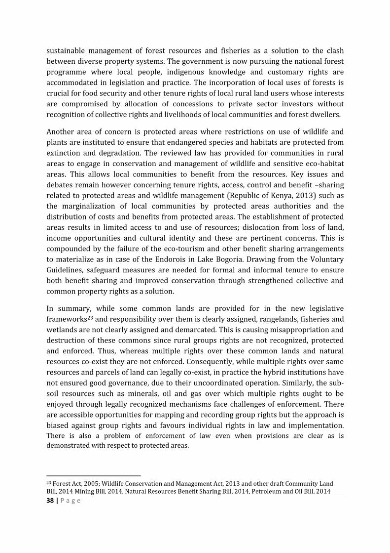
38 | P a g e
sustainable management of forest resources and fisheries as a solution to the clash
between diverse property systems. The government is now pursuing the national forest
programme where local people, indigenous knowledge and customary rights are
accommodated in legislation and practice. The incorporation of local uses of forests is
crucial for food security and other tenure rights of local rural land users whose interests
are compromised by allocation of concessions to private sector investors without
recognition of collective rights and livelihoods of local communities and forest dwellers.
Another area of concern is protected areas where restrictions on use of wildlife and
plants are instituted to ensure that endangered species and habitats are protected from
extinction and degradation. The reviewed law has provided for communities in rural
areas to engage in conservation and management of wildlife and sensitive eco-habitat
areas. This allows local communities to benefit from the resources. Key issues and
debates remain however concerning tenure rights, access, control and benefit –sharing
related to protected areas and wildlife management (Republic of Kenya, 2013) such as
the marginalization of local communities by protected areas authorities and the
distribution of costs and benefits from protected areas. The establishment of protected
areas results in limited access to and use of resources; dislocation from loss of land,
income opportunities and cultural identity and these are pertinent concerns. This is
compounded by the failure of the eco-tourism and other benefit sharing arrangements
to materialize as in case of the Endorois in Lake Bogoria. Drawing from the Voluntary
Guidelines, safeguard measures are needed for formal and informal tenure to ensure
both benefit sharing and improved conservation through strengthened collective and
common property rights as a solution.
In summary, while some common lands are provided for in the new legislative
frameworks23 and responsibility over them is clearly assigned, rangelands, fisheries and
wetlands are not clearly assigned and demarcated. This is causing misappropriation and
destruction of these commons since rural groups rights are not recognized, protected
and enforced. Thus, whereas multiple rights over these common lands and natural
resources co-exist they are not enforced. Consequently, while multiple rights over same
resources and parcels of land can legally co-exist, in practice the hybrid institutions have
not ensured good governance, due to their uncoordinated operation. Similarly, the sub-
soil resources such as minerals, oil and gas over which multiple rights ought to be
enjoyed through legally recognized mechanisms face challenges of enforcement. There
are accessible opportunities for mapping and recording group rights but the approach is
biased against group rights and favours individual rights in law and implementation.
There is also a problem of enforcement of law even when provisions are clear as is
demonstrated with respect to protected areas.
23 Forest Act, 2005; Wildlife Conservation and Management Act, 2013 and other draft Community Land Bill, 2014 Mining Bill, 2014, Natural Resources Benefit Sharing Bill, 2014, Petroleum and Oil Bill, 2014
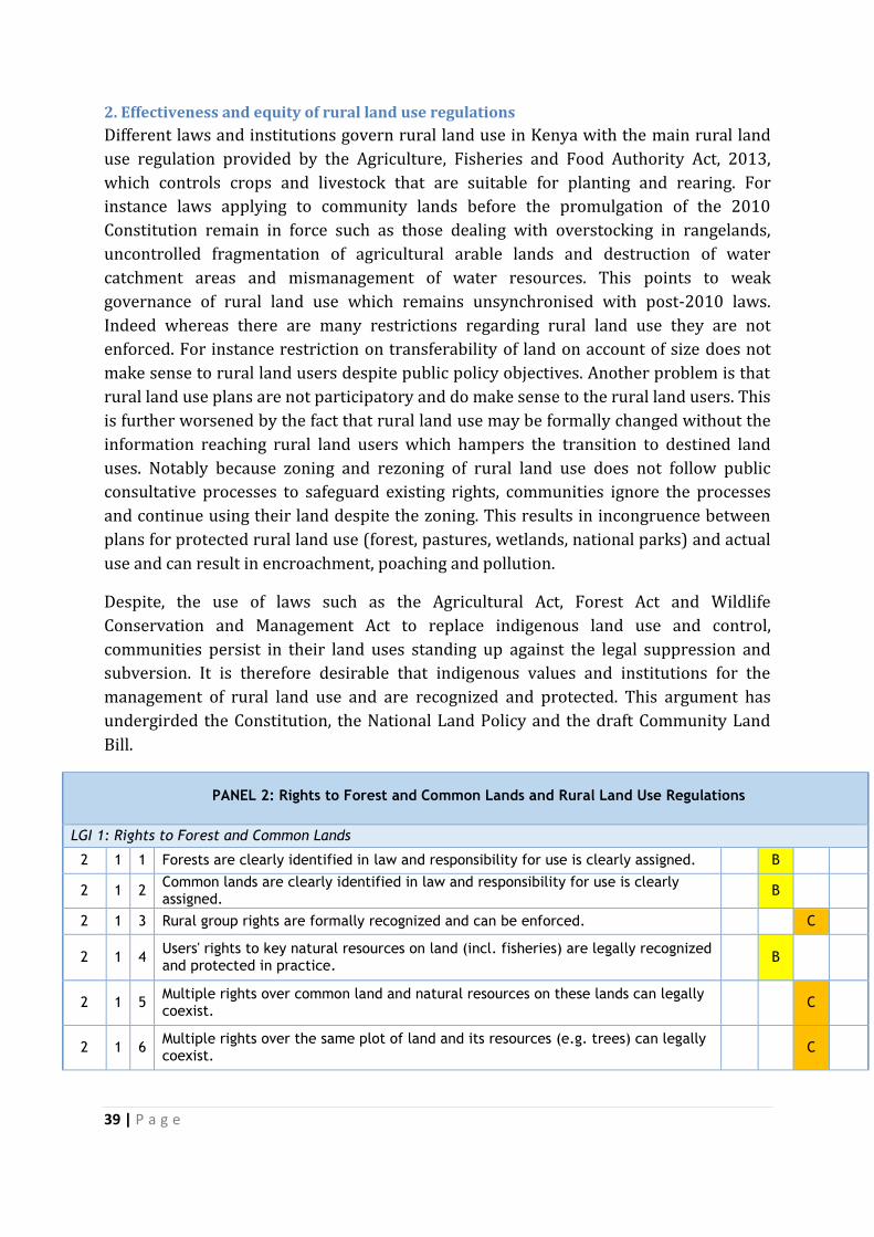
39 | P a g e
2. Effectiveness and equity of rural land use regulations
Different laws and institutions govern rural land use in Kenya with the main rural land
use regulation provided by the Agriculture, Fisheries and Food Authority Act, 2013,
which controls crops and livestock that are suitable for planting and rearing. For
instance laws applying to community lands before the promulgation of the 2010
Constitution remain in force such as those dealing with overstocking in rangelands,
uncontrolled fragmentation of agricultural arable lands and destruction of water
catchment areas and mismanagement of water resources. This points to weak
governance of rural land use which remains unsynchronised with post-2010 laws.
Indeed whereas there are many restrictions regarding rural land use they are not
enforced. For instance restriction on transferability of land on account of size does not
make sense to rural land users despite public policy objectives. Another problem is that
rural land use plans are not participatory and do make sense to the rural land users. This
is further worsened by the fact that rural land use may be formally changed without the
information reaching rural land users which hampers the transition to destined land
uses. Notably because zoning and rezoning of rural land use does not follow public
consultative processes to safeguard existing rights, communities ignore the processes
and continue using their land despite the zoning. This results in incongruence between
plans for protected rural land use (forest, pastures, wetlands, national parks) and actual
use and can result in encroachment, poaching and pollution.
Despite, the use of laws such as the Agricultural Act, Forest Act and Wildlife
Conservation and Management Act to replace indigenous land use and control,
communities persist in their land uses standing up against the legal suppression and
subversion. It is therefore desirable that indigenous values and institutions for the
management of rural land use and are recognized and protected. This argument has
undergirded the Constitution, the National Land Policy and the draft Community Land
Bill.
PANEL 2: Rights to Forest and Common Lands and Rural Land Use Regulations
A B C D
LGI 1: Rights to Forest and Common Lands
2 1 1 Forests are clearly identified in law and responsibility for use is clearly assigned. B
2 1 2 Common lands are clearly identified in law and responsibility for use is clearly assigned.
B
2 1 3 Rural group rights are formally recognized and can be enforced. C
2 1 4 Users' rights to key natural resources on land (incl. fisheries) are legally recognized and protected in practice.
B
2 1 5 Multiple rights over common land and natural resources on these lands can legally coexist.
C
2 1 6 Multiple rights over the same plot of land and its resources (e.g. trees) can legally coexist.
C
40 | P a g e
2 1 7 Multiple rights over land and mining/other sub-soil resources located on the same plot can legally coexist.
D
2 1 8 Accessible opportunities exist for mapping and recording of group rights. C
2 1 9 Boundary demarcation of communal land. C
LGI 2: Effectiveness and equity of rural land use regulations
2 2 1 Restrictions regarding rural land use are justified and enforced. B
2 2 2 Restrictions on rural land transferability effectively serve public policy objectives. B
2 2 3 Rural land use plans are elaborated/changed via public process and resulting burdens are shared.
B
2 2 4 Rural lands, the use of which is changed, are swiftly transferred to the destined use.
C
2 2 5 Rezoning of rural land use follows a public process that safeguards existing rights. B
2 2 6 For protected rural land use (forest, pastures, wetlands, national parks, etc.) plans correspond to actual use.
B
3. Recommendations
Given the flurry of legislating to align laws to the Constitution, Kenya can benefit from reference to the FAO Voluntary Guidelines on the Responsible Governance of
Tenure of Land, Fisheries and Forests in the Context of National Food Security24 in dealing with commons resources such as forests and fisheries.
Need for safeguard measures to secure informal tenure for communities using commons and recognition and protection of indigenous values and institutions in rural land use.
C. Urban Land Use, Planning and Development
1. Restriction on rights
In general terms, there are differentiated user rights on land defined under the Urban
Planning Act that is currently under review. A differentiated user right on land refers to
different rights to land – Private (freehold, leasehold); Community; and Public; user
rights (temporary occupation licenses, leases and access rights). This implies some form
of restriction based on use, user and time, yet it is often difficult to assess the
effectiveness of these policies. Despite the existence of restrictions on urban land
ownership and transfer, they have not effectively served public policy objectives imbued
in constitutional principles such as (i) equity and inclusiveness; (ii) equity of
opportunities; (iii) delinking politics and policy; (iv) better access to national resources;
and, (v) bringing government closer to the people. This is evidenced in the illegal
occupation and development of either public land or fragile eco-systems such as riparian
24 http://www.fao.org/docrep/016/i2801e/i2801e.pdf
41 | P a g e
land. The numerous rock falls25, flooding and demolitions are indicators that
restrictions on urban land use are not adequately implemented and enforced.
Whilst the process of urban expansion/infrastructure development is well outlined on
paper, it is not publicly available and it is not done in a transparent manner and the
rights of those affected are dealt with in an ad hoc manner.
2. Transparency of land use restrictions
Land in Kenya is registered under three registration regimes (that is, The Land Act 2012,
The Land Registration Act 2012 and The National Land Commission Act 2012.These
Legal regime replaced the past regimes which included amongst other laws; The Land
Titles Act (Chapter 282)26, The Registration of Titles Act 1924 (Cap. 230), The
Registration of Land Act (cap 300)27, The Government Land Act (Cap 280)28 and The
Indian Transfer of Property Act (1882)29 have now been repealed and replaced by the
Land Act, the National Land Commission Land and the Land Registration Act. The Land
Registration Act provides for registration unit at every district and the land registries
established under the repealed laws are still operational. Although Land Registration Act
denied transfer methods as did the Registration of Titles Act, Land in Kenya is generally
treated as a ‘political commodity’30 and for this reason land transfer is generally
clouded in secrecy and corruption. Land conversions (mainly from public land to
private) have been used to dispossess poor Kenyans and the public. Processes
highlighted in the then Government Lands Act were disregarded in urban expansion,
infrastructure development and changes in urban land use plans. Even though the
National Land Commission has a mandate to reverse some of these anomalies under the
National Land Commission Land Act and the Land Registration Act very little has been
done to date.
25 There have been numerous such cases in Mathare slums see- Zadok Angira “Four killed as rock rolls
onto Kenya's Mathare slum houses” in Daily Nation, Wednesday, April 4 2012 26 Commencement Date: 11/30/1908
27 Revised Edition 2010 (1989) 28 Revised Edition 2010 (1984). 29 Revised Edition 2010 (1962)
30 Land transfer is done both in the context of politicized ethnicity and ethicized politics. This notion has had a bearing on who owns land where and whether a land registration document is more important than claims of autochthony. Such is evidence from data of post elections violence witnessed between December 2007 and January 2008 in part of Kenya. The other meaning relates to use of land as a reward to political supporters and chorines. The Report by the Commission of Inquiry on the Illegal and Irregularly Allocated Land, commonly known as the Ndungu Land Report accounts in much details of how land was used to reward chorines and supporters without regard to laid down processes and procedures.

42 | P a g e
The questions of transparent and respect for existing rights in urban expansion and
infrastructure development is reflected best in Kisumu’s urban growth31 which has had
to contend with the dual zoning characterised by ambiguity between the rural and the
urban parts regulated under different land use and tenure regimes. Since 1972, the town
has had two distinct land proprietorship zones: land under leasehold32 in the old part of
town and freehold33 for land outside this part. Much of the land in the old town was
owned by the Railways.34 As part of the expansion of the urban area in the 1972, the
municipality of Kisumu acquired land compulsorily in the low-lying Kanyakwar area
north of the town, as a land bank for future development. State officials have often
stated that the residents were compensated and removed. Yet, neither the municipal or
central government moved in to secure the land nor was there any physical
development plans to allocate the land. Consequently, the land was occupied and some
of it registered the Registration of Titles Act by land speculators who were mainly based
in Nairobi. The land is not administered at the Kisumu Lands Office and does not appear
on its index maps. Most of the leases issued by the Council were for periods between 30-
45 years and lessees did not renew them. This provided a window for land speculators
to disposes the poor and vulnerable lessees as well as the Municipality and to transfer
land from public to private ownership.
The Kisumu case, which is not unique, illustrates the fact that the process of planning
and implementation of urban expansion/infrastructure development is not transparent
and does not often respect existing rights.35 Urban land use plans are rarely based on a
clear public process and there is minimal input by stakeholders which implies that the
resulting burdens are not shared. While urban residents have been involved in some
instances especially in the development of county integrated development plans, it is
cannot be stated that these processes are generally transparent and respect existing
rights. This explains why this dimension is ranked between C and D. The panellists were
evenly split between the two scores.
3. Efficiency in the urban land use planning process
There has been an upsurge of housing development in the last decade in Kenya mostly
for the upper and middle class income categories. National programmes such as the
31 See Robert Home (ed). 201. Local Case studies in African land Laws. University of Pretoria: Pretoria University Law Press. 32 These defined by fixed boundaries, allowing land owners in collusion with land surveyors to apply for official boundaries corrections. These actors have often used that opportunity to enlarge their land into acquired titled land which appear as blank in registry index map. This is often what has resulted to double ownership of land parcels as they are registered under two different statutes. In such cases both registrations are legal registered for the same physical space but under two different legal regimes and different registries (Kisumu and Nairobi) 33 Freeholds are defined by general boundaries allowing a large margin of error. 34 It should be noted from the History of Nairobi above that at in the colonial period, the Railways was the largely land and asset owners in most urban areas. At any rate, the railway at the time was almost synonymous to Government. 35 While there seem to be potential change of practice in the implementation of the Standard Gauge Railways, often compensation is preceded by land grabbing, illegitimate political interest and poor bureaucratic coordination.
43 | P a g e
Kenya Slum Upgrading Programme (KENSUP) and the Kenya Informal Settlement
Improvement Project (KISIP) have also been instituted. KISIP is a five-year project
(2011 to 2016) targeting 15 Municipalities. These are however not anchored on a
comprehensive policy, legal and institutional framework to ensure delivery of low cost
housing and services.
On land use planning, the expansion of Nairobi presents the best example whose
internal structure including the road network had been developed by 1909.36 The
boundary of Nairobi was however extended in 1927 as a result of the rapid growth of
the urban centre both in terms of population and infrastructure. From 1928 to 1963, this
boundary remained the same with only minor additions and excisions taking place.
In1963, the boundary was extended to cover an area of approximately 686 km2 from
the previous 77 km2.37 Under the new Constitutional dispensation, Nairobi County is
required to develop an Integrated Urban Development Plan. This will be done against
the backdrop of current patterns of inequality in urban land use, access and illegal land
allocation in most parts of the city. This will nuance the commitment by city authorities
in Nairobi, Kisumu and Mombasa to rely on land use planning in urban development
evident in the last five years.
It is worth noting that The Environmental Management and Coordination Act 1999 and
existing Planning Act are largely adequate to guide urban development but they are
largely disregarded. The ongoing review of these laws is encouraging but enforcement
must be ensured.
4. Speed and predictability of enforcement of restricted land uses
Most regulations on building permits are under review. However, it is apparent that the
current practices in standards of housing, building permits, zoning and infrastructure
development have eclipsed policy provisions. Take the emergence of tenements in most
parts of Nairobi, Mombasa and Kisumu for instance. These have disrupted the building
code regime and paved way for new reflections in formalization of urban residential
housing that is feasible and affordable. Besides past initiatives to address the slum
question by the government, local authorities, Non Governmental Organizations (NGOs),
Community Based Organizations (CBOs), Faith Based Organizations (FBOs), Private
Sector and Development Partners have not yielded the required change as each usually
works independently of the other. In addition, there is lack of a comprehensive legal,
regulatory and institutional framework, insufficient funding and challenges related to
housing market forces (gentrification). Increased investments in urban areas such as
Nairobi - infrastructure, provision of basic services and industries- have had a role in the
current ‘land use pressure’.
36 Winnie Mitullah, UNDERSTANDING SLUMS: Case Studies for the Global Report on Human Settlements 2003. 37 Ibid
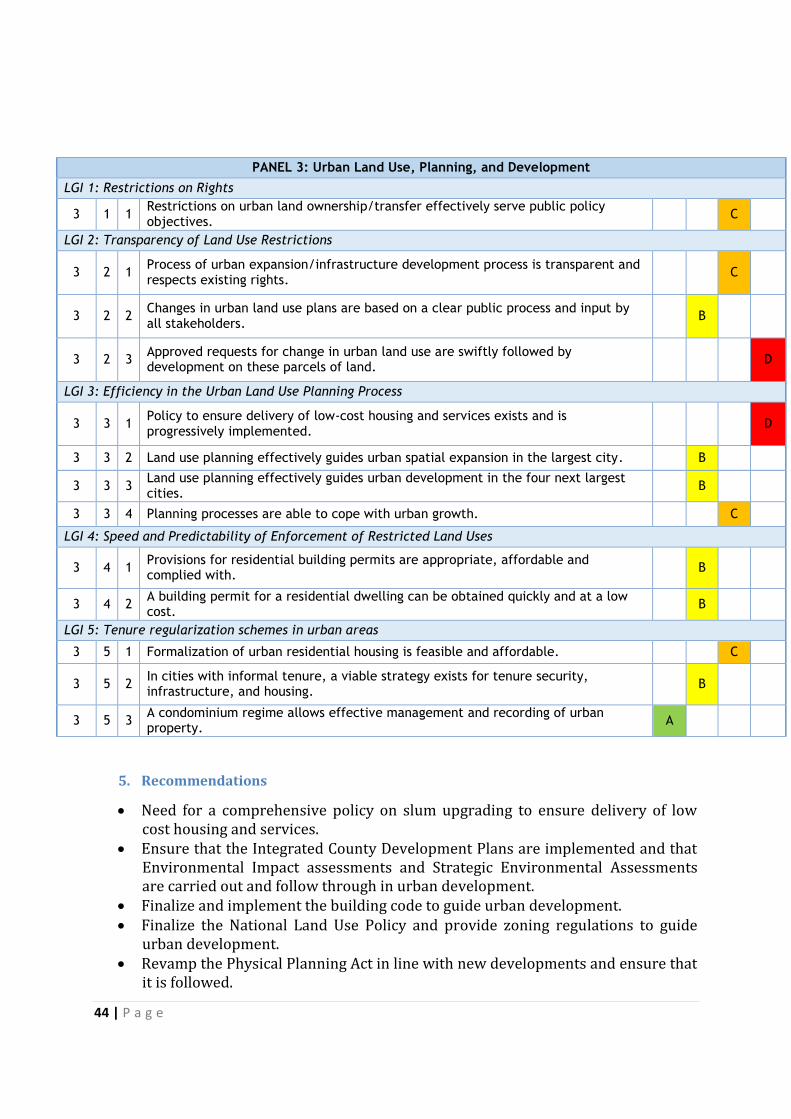
44 | P a g e
PANEL 3: Urban Land Use, Planning, and Development
LGI 1: Restrictions on Rights
3 1 1 Restrictions on urban land ownership/transfer effectively serve public policy objectives.
C
LGI 2: Transparency of Land Use Restrictions
3 2 1 Process of urban expansion/infrastructure development process is transparent and respects existing rights.
C
3 2 2 Changes in urban land use plans are based on a clear public process and input by all stakeholders.
B
3 2 3 Approved requests for change in urban land use are swiftly followed by development on these parcels of land.
D
LGI 3: Efficiency in the Urban Land Use Planning Process
3 3 1 Policy to ensure delivery of low-cost housing and services exists and is progressively implemented.
D
3 3 2 Land use planning effectively guides urban spatial expansion in the largest city. B
3 3 3 Land use planning effectively guides urban development in the four next largest cities.
B
3 3 4 Planning processes are able to cope with urban growth. C
LGI 4: Speed and Predictability of Enforcement of Restricted Land Uses
3 4 1 Provisions for residential building permits are appropriate, affordable and complied with.
B
3 4 2 A building permit for a residential dwelling can be obtained quickly and at a low cost.
B
LGI 5: Tenure regularization schemes in urban areas
3 5 1 Formalization of urban residential housing is feasible and affordable. C
3 5 2 In cities with informal tenure, a viable strategy exists for tenure security, infrastructure, and housing.
B
3 5 3 A condominium regime allows effective management and recording of urban property.
A
5. Recommendations
Need for a comprehensive policy on slum upgrading to ensure delivery of low cost housing and services.
Ensure that the Integrated County Development Plans are implemented and that Environmental Impact assessments and Strategic Environmental Assessments are carried out and follow through in urban development.
Finalize and implement the building code to guide urban development. Finalize the National Land Use Policy and provide zoning regulations to guide
urban development. Revamp the Physical Planning Act in line with new developments and ensure that
it is followed.
45 | P a g e
Streamline process of land use change and ensure that land use transitions to destined use
D. Public Land Management
1. Definition, Identification and Management of Public Land in Kenya
According to the Kenya National Land Policy paragraph 59 public land is defined as ‘all
land that is not private land or community land and any other land declared to be public
land by an Act of Parliament’. Thus, apart from this broad categorization of public land
there is no system for registering public land held numerously by public institutions and
agencies. Therefore, there is no updated inventory of public land holding and use in
place. Nonetheless at Article 61(1) (a-n) of the Constitution of Kenya, 2010 clearly
classifies public land to include:
Un-alienated government land as of August 27, 2010 when the Constitution of
Kenya was promulgated;
Land lawfully held, used or occupied by state organs and agencies except those
lands leased from private parties;
Land transferred to the state by sale, reversion or surrender;
Land whose individual or community ownership or heir cannot be established by
any legal process;
All minerals and mineral oils as defined by law;
Gazetted forests other than community forests held, managed or used by specific
communities;
Government game reserves, water catchment areas, national parks, government
animal sanctuaries and specifically protected areas;
All roads and thoroughfares provided for by an Act of Parliament;
All rivers, lakes and other water bodies as defined by an Act of Parliament;
Territorial sea, the exclusive economic zone and sea bed, plus the continental
shelf, including all land between the high and low water mark.
In theory all these lands are vested in and held by the county and/or national
government in trust for the people of Kenya and are administered and managed on their
behalf by the National Land Commission as per Article 62 (3) of the Constitution of
Kenya, 2010. Public land should therefore not be disposed of or otherwise used except
in terms of an Act of Parliament specifying the nature and terms of that disposal or use
as provided in Part II of the Land Act No. 6 of 2012 on Management of Public Land.
Public land in Kenya is categorized under public tenure regime to be managed, acquired
and disposed of for public good, public interest, and public purpose. According to 200438
Bureau of Statistics public land comprises approximately 12.99 percent of all land in
Kenya. Data on the current acreage of public land is sparse and the only available data is
38 There is no updated record since 2004
46 | P a g e
over 10 years old. There has doubtless been change in public land holding and
distribution by use and region. The Coast and Rift Valley regions have had the large
proportion of public land measuring due to sparse population at the time of colonial
expropriation.
There are a number of institutions both at vertical and horizontal levels charged with
management of different types of public land. These include NLC, Ministry of Land,
Housing and Urban Development, Ministry of Environment, Water and Natural
Resources, Ministry of Mining, Ministry of Agriculture, Livestock and Fisheries, Ministry
of Transport and Infrastructure, Ministry of Energy and Petroleum, Ministry of
Industrialization and Enterprises among others. Attendant public agencies, state
corporations, most prominent among them being Kenya Forest Service, Kenya Wildlife
Service, Water Resources and Management Authority, Kenya Maritime Authority,
National Environment and Management Authority, Lake Basin Development Authority,
Tana and Athi River Development Authority, Coast Development Authority, Kerio Valley
Development Authority among others. Whereas all statutory bodies and public agencies
have responsibilities over different types of public land, the NLC has a monitoring and
oversight mandate to ensure collaboration, co-operation, consultation, information
sharing and stakeholder participation in line with Article 10 of the Constitution.
There is an ongoing dispute between the Ministry of Land, Housing and Urban
Development and the NLC on their respective roles owing to contradictory and
inconsistent sections of the Land Act, the Land Registration Act and the National Land
Commission Act. The remedy would be the amendment of the laws to align them with
the Constitution. There is a proposed amendment to the laws which essentially whittles
down the role of the NLC in land maters and transfers most functions to the Ministry.
This is in line with the National Executive Order No. 3 assigning the Cabinet Secretary in-
charge of land matters with management and administration of public land.
Effective management of public land is predicated on an updated inventory of all
categories of public land with clearly defined boundaries. In the absence of such an
inventory, the acreage of public land continues to change with a substantial amount
being converted to private land.39 Access and availability of information to the public on
public land whether free or at a ‘fee’ is important to ensure efficient, transparent and fair
dealings in public land. This includes information on processes for managing public land,
recorded interests in such land, assessment of land value, determination of property tax
and definition of land use. Such information is not currently freely accessible and this
makes informed public participation in public land administration and management
difficult.
39 This is widespread given the seamless number of squatters, informal and unplanned settlements, the land grabbing mania of social amenities spaces such as schools, health services parcels, recreational parks and similar social public utility spaces all over the country as revealed by Ndung’u Commission report, other Parliamentary Investigation Committee reports and the media reports.
47 | P a g e
The NLC is expected to identify and keep an inventory of all public land but currently
there is no system of registering such land. NLC has been in existence for two years but
it is yet to develop the registration system. Thus, whereas the Constitution of Kenya,
2010 at Article 62(2) (a-b) and 62(3) has assigned different types of public land to the
county and national levels of government, there is no complete record of public land.
The Ministry in-charge of lands and the NLC both lack the requisite capacity. There are
plans of computerizing the inventory if budget allocations allow. According to the Land
Act No. 6 of 2012 at Section 10 the NLC is supposed to prescribe guidelines on the
management of public land by all public agencies, statutory bodies and state
corporations in actual occupation or use of public land. The NLC has also not finalized
the regulatory framework coordinating different public agencies responsible for
managing different types of public land contrary to the new constitutional dispensation.
2. Justification, Efficiency, Transparency and Fairness of Acquisition Processes
Securing land for public purposes is the duty of the NLC which is mandated to
compulsorily acquire land for the public good, public interest and public purpose as
provided under Article 40 of the Constitution of Kenya. The Land Act, No. 6 of 2012 in
Part VIII provides operational detail on how the NLC is mandated to acquire land for the
national or county government. The acquired land can only be used for public interest or
private undertaking for satisfaction of public purpose. In theory the acquired land must
be transferred to destined use in a timely manner, otherwise the Section on compulsory
acquisition of interests in land provides for the withdrawal of acquisition, temporary
occupation, restoration of land and eventually reference to the Environment and Land
Court in any event of dispute arising out of the process. Under Article 40 (3) of the
Constitution of Kenya, 2010 private parties who are threatened by the demand for land
acquisition can seek pre-emptive action.
The Land Act No. 6 of 2012 at Section 107 (2) mandates the NLC to prescribe a criteria
and guidelines to be adhered to in acquisition of land, but unfortunately the regulations
that are supposed to promote transparency and fair process remain in draft form since
2013. The hue and cry over acquisition of land for Lamu Port–South Sudan and Ethiopia
Transport (LAPSSET) corridor, Super Gauge Railway (SGR) line and the improvement of
the Northern Corridor is a pointer to the procedures being followed. They are the old
procedures that are not very clear or transparent leading to unnecessary complaints
about compensation not paid expeditiously. Not surprisingly, cases of land use change
resulting in selective compensation for loss of rights have been reported in the local
press.
Evidence so far shows that acquired land owners are not being compensated promptly
hence delays in infrastructure projects due to appeals. Some poor land owners are
unable to access independent avenues because they cannot raise court fees and legal
costs to hire competent and dependable legal representation services.
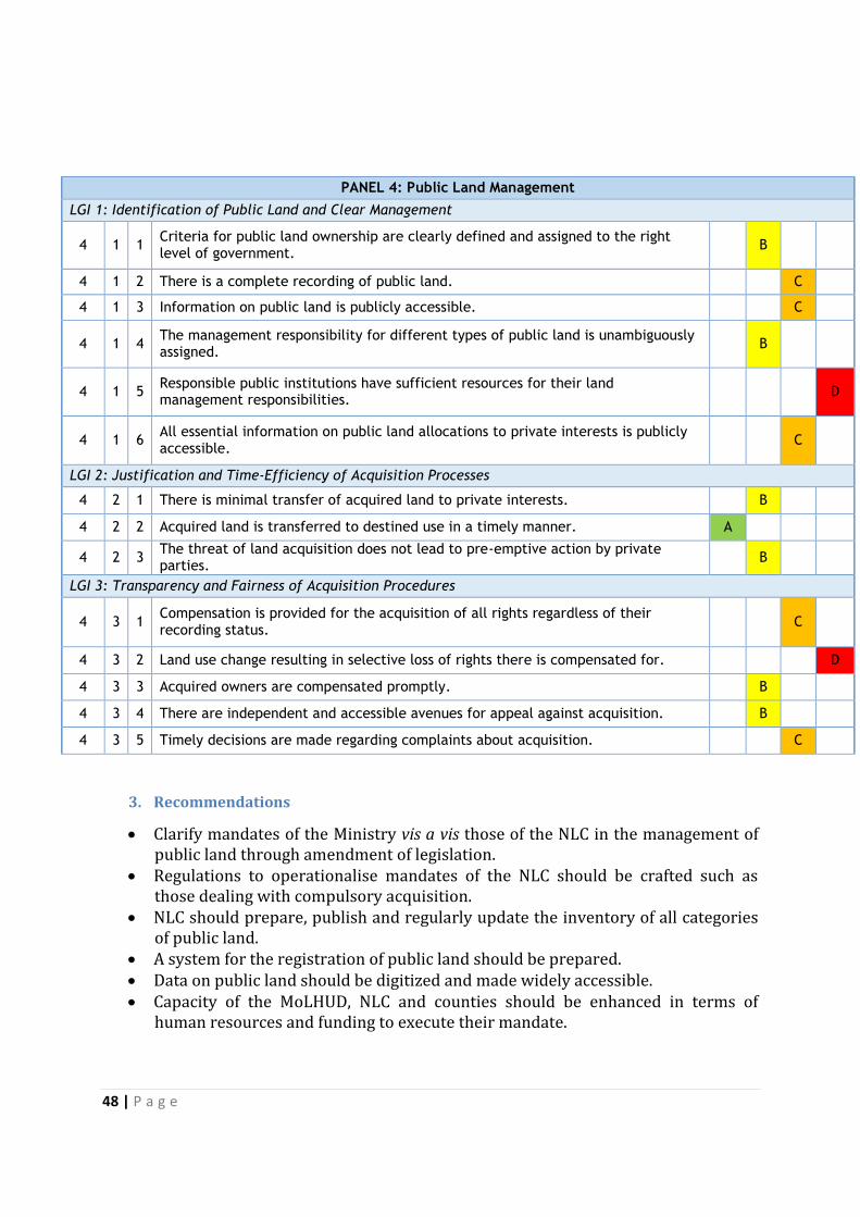
48 | P a g e
PANEL 4: Public Land Management
LGI 1: Identification of Public Land and Clear Management
4 1 1 Criteria for public land ownership are clearly defined and assigned to the right level of government.
B
4 1 2 There is a complete recording of public land. C
4 1 3 Information on public land is publicly accessible. C
4 1 4 The management responsibility for different types of public land is unambiguously assigned.
B
4 1 5 Responsible public institutions have sufficient resources for their land management responsibilities.
D
4 1 6 All essential information on public land allocations to private interests is publicly accessible.
C
LGI 2: Justification and Time-Efficiency of Acquisition Processes
4 2 1 There is minimal transfer of acquired land to private interests. B
4 2 2 Acquired land is transferred to destined use in a timely manner. A
4 2 3 The threat of land acquisition does not lead to pre-emptive action by private parties.
B
LGI 3: Transparency and Fairness of Acquisition Procedures
4 3 1 Compensation is provided for the acquisition of all rights regardless of their recording status.
C
4 3 2 Land use change resulting in selective loss of rights there is compensated for. D
4 3 3 Acquired owners are compensated promptly. B
4 3 4 There are independent and accessible avenues for appeal against acquisition. B
4 3 5 Timely decisions are made regarding complaints about acquisition. C
3. Recommendations
Clarify mandates of the Ministry vis a vis those of the NLC in the management of public land through amendment of legislation.
Regulations to operationalise mandates of the NLC should be crafted such as those dealing with compulsory acquisition.
NLC should prepare, publish and regularly update the inventory of all categories of public land.
A system for the registration of public land should be prepared. Data on public land should be digitized and made widely accessible. Capacity of the MoLHUD, NLC and counties should be enhanced in terms of
human resources and funding to execute their mandate.
49 | P a g e
E. Transparent Process and Economic Benefit from the Transfer of Public
Land to Private
1. Procedure of Transfer of Public Land to Private Use Good governance demands transparency and mandates the agency charged with the
management of public land in Kenya (NLC) to follow laid down procedures; adhere to
the relevant notices, formats, period; and provide opportunity for public participation.
Section 12 of the Land Act, 2012 empowers the NLC to set aside land for investment
purposes while Section 9 provides that land may be converted from one category to
another in accordance with the country’s land law framework. Conversion of public land
to private land is required, under sub-section 2 (a), to be done through alienation or
allocation where the governing authority grants land rights to its citizen for use under
certain terms and covenants. Where the conversion involves a substantial transaction
subsection 3 provides that the approval of the National assembly and County Assembly
be sought. The Act does not however clarify what qualifies as substantial which can lead
to abuse.
As pointed out above, the NLC is required to keep a register of all public land converted
to private land by alienation. The Land Act is clear on the procedure to be followed in
disposition of public land but official data on public advertisements for such dispositions
is hard to come by. Most public land disposition transactions are only publicized through
public outcries over the process. Sections 11 and 12 of the Land Act mandate the NLC to
make regulations prescribing the criteria and process of allocation. This has not been
done so far. There is need to hasten the regulations to operationalise the allocation
procedures.
Tracking of public leases’ payments under the previous land management regime is
inefficient and led to loss of considerable amounts of revenue. With the new laws, the
timeframes for land rent clearance have improved from 19 days to 2 days. The
Integrated Financial Management Information System (IFMIS) has also provided a
platform that ensures all revenue is collected and delivered to the rightful custodians.
Though an important solution to corrupt dealings, it is important to note that just like
any other information system it is open to abuse and misuse leading to further
ineffectiveness and inefficiency.40 It is also instructive to note that local governments
incentivize people into paying through provision of interest waivers on accrued debts
from non-payments of rates. There is need to introduce modern finance management
information systems at both national and county levels and hold people accountable for
lost funds through prosecution. It is not possible to tell whether payments for public
leases are collected effectively because the data is not available. The panelists could not
agree on a score. Half rated it at C from anecdotal evidence while the other half rated it
at D on account of non-availability of public records of payments.
40 The much publicized case where the National Youth Service lost Kshs. 791,000,000 is a case in point
50 | P a g e
The NLC may allocate land through public auction, public tenders, public drawing of lots,
public request for proposals and public exchanges of land of equal value. Cases of public
land converted to private use without following the laid down regulations were common
before the Land Act and may still be happening in areas where expropriation for oil and
minerals are taking place. There is no data under the new laws to indicate how and
whether the publicisation of public land allocation processes has improved. Anecdotal
evidence presents in instances where local communities threaten to stop investments on
account of non-involvement in the processes. These have been witnessed in Turkana,
Baringo and Kitui counties.
In allocating land through public auction, it is a legal requirement that prices be pegged
at prevailing market value. One of the key and mandatory land administration processes
in any public land transfer process is land valuation which is done by officers from the
Ministry of Lands’ Valuation Department. This process is not as transparent as it ought
to be and sometimes different values are returned for the same property. This is because
the parameters of valuation are not standardized. 41 International Valuation standards
should be followed to avoid very varied valuations for the piece of land.
2. Involvement of Stakeholders
The Constitution puts a premium on the involvement of stakeholders in governance at
Article 10. It also requires that agreements involving grant of rights or concessions for
the exploitation of any natural resource in Kenya is subject to ratification by Parliament
thus providing more room for participation through elected leaders.42
Before any development is undertaken, investors are required to explain how their
investments are going to benefit the country on the basis of criteria set by the Kenya
Investment Authority (KIA). These include: type of business, business location, country
of incorporation, name of the investor, company directors, market (domestic and
export), projected investment growth, employment details (both local and foreign
expatriates), and investment and financing programmes details. The investor must also
register the company locally and pay both Corporate Income and Value Added taxes
among others. In drafting the investment strategy, the following information should be
integrated: the minimum financial investment; creation of employment; acquisition of
new skills or technology; contribution to tax revenues or other government revenues;
transfer of technology; an increase in foreign exchange, either through exports or import
substitution; utilization of domestic raw materials, supplies and services; adoption of
value addition in the processing of local, natural and agricultural resources; and
utilization, promotion, development and implementation of information and
communication technology.
41 See Part G on Valuation and Taxation. 42 Article 71 of the Constitution

51 | P a g e
In considering public land allocation for investment and development purposes, the
County Land Management Boards (CLMB) require the investor to clearly stipulate
considerations made for planning standards, density control, plot ratio, traffic and
parking, and zoning. The legal framework is quite demanding of the investors and most
projects end up requesting for more funding, winding up or failing to complete the
project.43 The Investment Promotion Act together with the institutions concerned need
to demand detailed feasibility studies and environment impact assessment (EIA) reports
before approving any business plans. The County Government acts in consultation with
the NLC and the CLMB to ensure that the process is consultative as possible and should
include all the technical and relevant authorities. The CLMB decision is required to be
accompanied by supporting documentation such as minutes and upon approval of the
physical development plan by the CLMB, the investor is granted land.
The investor is required to seek necessary approvals from other relevant authorities and
is required to ensure that the investment is lawful and beneficial to Kenya. Both local
and foreign investors must seek the approval of their plans from the KIA following the
set out procedure in the Kenya Investment Promotion Act. This process should be
streamlined to reduce timelines and align them with international best practices to
make Kenya attractive to investors.
The process of transferring of public land to private land use by the NLC is guided by the
Constitution; Vision 2030; the National Land Policy; land legislation; Urban
Development and other Sectoral policies. In this process, transparency in the exchange
process, and access to information are two critical considerations as the Constitution
provides for the right of access to information for all Kenyans. The allottee must use the
allocated public land for the purpose for which it was allocated. To ensure transparency
and community participation, the terms of land allocation are available at the NLC
offices in Nairobi and the Commission’s office nearest the land being proposed for
allocation.
While the land rights are clear in most cases, it is usually expensive for the rights’
holders to engage the investors owing to asymmetries in financial resource and general
capacity endowment. This tilts the balance of the negotiations in favour of the investors
to the detriment of the land owners. In most cases civil society organizations step in to
assist the owners but the interests of their funders may also compromise the process.
Publicisation of contracts is premised on the Constitution’s requirement that all Kenyans
have a right to access to information. Transparency of contracts is also bolstered by the
Constitutional requirement for parliamentary ratification of natural resources’
43 W. Mwangi & D. Mbugua, Land Governance Assessment Framework in Kenya: Policy Paper and Ranking,
Theme 5: Transparent Process and Economic Benefit: Transfer of Public Land to Private Use follows a
Clear, Transparent, and Competitive Process, 2015
52 | P a g e
exploitation transactions. In allocating land for investment, the NLC must further ensure
that mechanisms are in place for sharing benefits with local communities whose land
has been set aside for investment. These modalities are part of the contractual terms and
the criteria for benefit sharing is required to be part of the business plan with the right
holders fully involved in determining the benefits. The Community Land Bill also
requires that any agreement on investment on community land shall provide for, and
contain all the necessary aspects as to how the community shall benefit from
investments in their land. Failure to adhere to these provisions can lead to conflicts with
the community as was witnessed in Turkana County in the investment by Tullow Oil.44
Agreements are rarely made public on account of the protection of confidential business
information and intellectual property rights. Not surprisingly, the prescribed
mechanisms are rarely followed. The regulations on benefit sharing are yet to be put in
place and the resettlement programmes for displaced persons have always been dogged
by corruption allegations involving manipulation of beneficiary lists; improper auditing
of the affected persons and non-involvement of the community members.45 The
enactment of the Evictions and Resettlement Bill would assist in this regard.
3. Private Investment Strategy
NLC is required to make investment plans public and facilitate a consultative process in
the investment decision making to ensure legitimacy and local acceptance of the
investment proposals. NLC is also legally mandated to keep a record of all public land to
private land transfers and avail it to the public. This provision is also included in the
Mining Bill which requires the responsible Cabinet Secretary (CS) to ensure access to
this information detailing Kenya’s mineral wealth including soil and mineral types. This
is however yet to be done and only the Ministry concerned is privy to the information
unless issues of compulsory acquisition arise.
Not much land is available for investment and the national and county governments
need to set aside funds in their budgets to procure land for investment purposes or put
in place incentives for private parties to release land for investment purposes. Public
institutions transferring land to investors are clearly identified and regularly audited.
The institutions are however understaffed especially the NLC. Capacity building of the
institutions in terms of training and funding is imperative if they are to effectively
perform their roles.
44 Daily Nation, Wednesday, October 30, 2013 Turkana MP under probe over riots against Tullow oil firm, http://www.nation.co.ke/news/MP-under-probe-over-Turkana-riots/-/1056/2053848/-/3rffmsz/-/index.html
45 Kenyan government accused of corrupt handling of IDP camps, Hague Trials, Wednesday, October 2,
2013, https://thehaguetrials.co.ke/article/kenyan-government-accused-corrupt-handling-idp-camps
53 | P a g e
Kenya has no land Use policy is in place though guidelines on land use and institutional
roles are derived from various legislative frameworks such as the Constitution and the
National Land Policy. As far as large scale land investments, there is inter-ministerial
and inter-sectoral coordination. The formulation and enactment of a national land use
policy should be fast tracked and the inter-ministerial and inter-sectoral coordination
should be strengthened to avoid overlaps.
The Land Act empowers the NLC to set specific legal undertakings to be observed by the
private investors. Breach of these legal undertakings should result in sanctions or
termination of the lease. This raises the need for a land administration monitoring tool
to ensure that the specific investment goals have been met. This should be continuous
and not reactive where the state only comes out after the occurrence of incidents. It
should also ensure adherence to sustainable development principles integrating social,
economic and environmental factors where land parcels are converted from public to
private use. The sustainability criteria in the conversion of public land to private use
include the application of EIA and Strategic Environmental Assessment (SEA) depending
on the nature and scale of the investment. There is need for more strict enforcement by
the National Environment Management Authority (NEMA) and other government
agencies in carrying out the assessments.
4. Accessibility and monitoring of contracts involving public land
As earlier mentioned the NLC in allocating public land for private land use is required to
ensure that the process is transparent, participatory and aimed at the best interests the
locals and their economy. To do so NLC is required to identify public land, prepare and
keep a geo-referenced and authenticated database of all public land and evaluate all
parcels of public land based on land capability classification, land resources mapping
consideration, overall potential for use, and resource evaluation data for land use
planning. This is to ensure the development of a comprehensive and integrated land
information management system or cadastre for public land. This is critical for efficient
allocation of public land. This process is not yet complete. A register detailing all land
converted from public land to private land use should also be prepared but is yet to be
done. Such information should be readily accessible and should indicate the place, date,
and time of allocation and the appraised value of the land. Regulations operationalising
the Land Act and Land Registration Act provisions on geo-referencing need to be fast
tracked and all spatial information availed. The enactment of the Mining Bill should also
be hastened. As is clear from the foregoing, the law and policy is clear but
implementation and enforcement lags behind. This is what should be done.
In allocating land, the NLC imposes terms, covenants, stipulations and reservations that
it deems appropriate. If the land allocated is not used for the assigned purpose, it reverts
to the national or county government. Due to perceived notion that investors are
benefiting the locals and with their financial might, they can unduly influence
compliance processes and standards to the detriment of the locals. Complaints may be
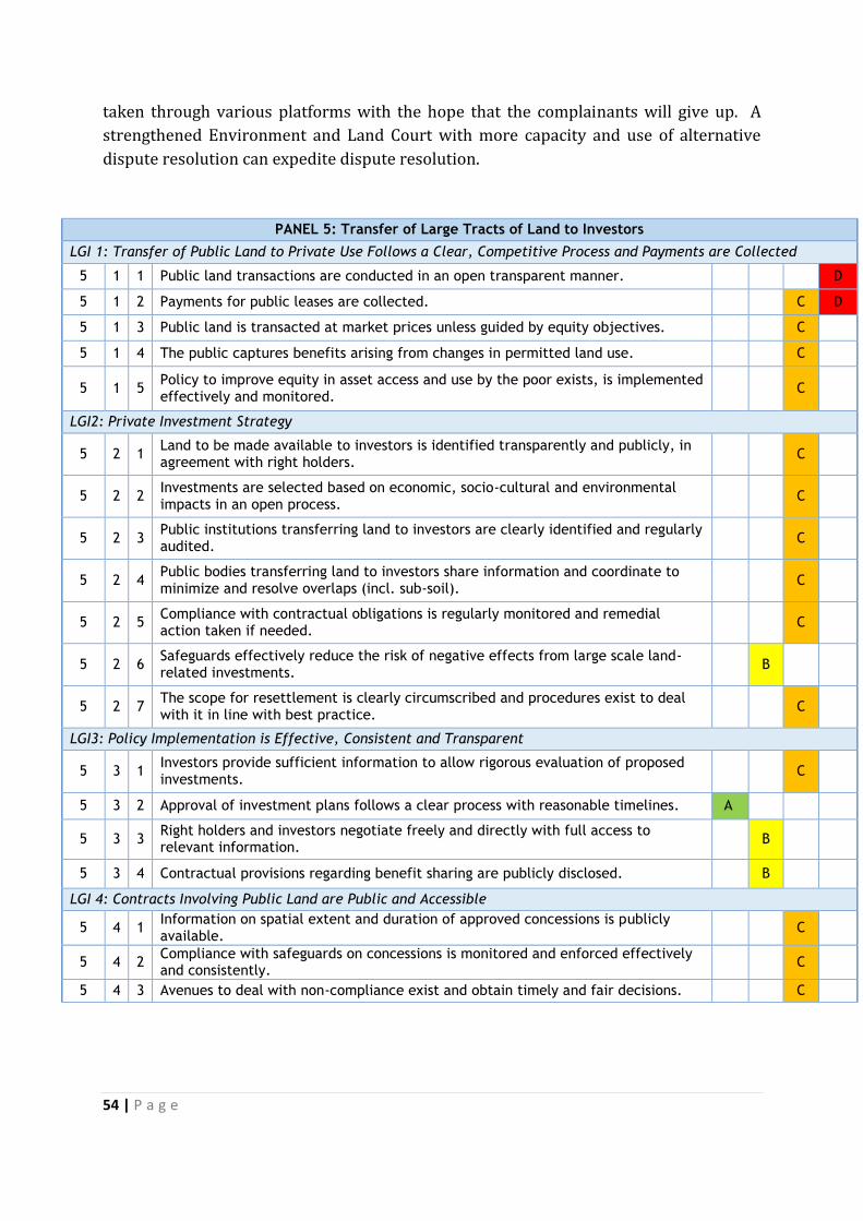
54 | P a g e
taken through various platforms with the hope that the complainants will give up. A
strengthened Environment and Land Court with more capacity and use of alternative
dispute resolution can expedite dispute resolution.
PANEL 5: Transfer of Large Tracts of Land to Investors
LGI 1: Transfer of Public Land to Private Use Follows a Clear, Competitive Process and Payments are Collected
5 1 1 Public land transactions are conducted in an open transparent manner. D
5 1 2 Payments for public leases are collected. C D
5 1 3 Public land is transacted at market prices unless guided by equity objectives. C
5 1 4 The public captures benefits arising from changes in permitted land use. C
5 1 5 Policy to improve equity in asset access and use by the poor exists, is implemented effectively and monitored.
C
LGI2: Private Investment Strategy
5 2 1 Land to be made available to investors is identified transparently and publicly, in agreement with right holders.
C
5 2 2 Investments are selected based on economic, socio-cultural and environmental impacts in an open process.
C
5 2 3 Public institutions transferring land to investors are clearly identified and regularly audited.
C
5 2 4 Public bodies transferring land to investors share information and coordinate to minimize and resolve overlaps (incl. sub-soil).
C
5 2 5 Compliance with contractual obligations is regularly monitored and remedial action taken if needed.
C
5 2 6 Safeguards effectively reduce the risk of negative effects from large scale land-related investments.
B
5 2 7 The scope for resettlement is clearly circumscribed and procedures exist to deal with it in line with best practice.
C
LGI3: Policy Implementation is Effective, Consistent and Transparent
5 3 1 Investors provide sufficient information to allow rigorous evaluation of proposed investments.
C
5 3 2 Approval of investment plans follows a clear process with reasonable timelines. A
5 3 3 Right holders and investors negotiate freely and directly with full access to relevant information.
B
5 3 4 Contractual provisions regarding benefit sharing are publicly disclosed. B
LGI 4: Contracts Involving Public Land are Public and Accessible
5 4 1 Information on spatial extent and duration of approved concessions is publicly available.
C
5 4 2 Compliance with safeguards on concessions is monitored and enforced effectively and consistently.
C
5 4 3 Avenues to deal with non-compliance exist and obtain timely and fair decisions. C
55 | P a g e
4. Recommendations
Need to finalize regulations on geo-referencing to provide spatial details of land converted to private use and registration of all such land
Need for a land administration tool to monitor respective agreements to ensure investment goals are met and conditions of transfer adhered to.
Need for modern finance information systems at national and county levels to enhance accountability.
Need to develop and publish benefit sharing regulations. Finalize the Mining Bill and Evictions and Resettlement Law Need for a National Land Use Policy to guide transfer of public land to private use. Need for harmonization with other regulatory agencies such as environmental
agencies to ensure sustainability criteria are observed. Define substantial conversions of public land to private use that require approval of
County and National assemblies
F. Public Provision of Land Information
1. Land information in Kenya
Land information consists of a spatial component, in terms of the geographical location
of the land and its area, plus the non-spatial component, in terms of the parcel attributes,
such as proprietor details (name, address, etc), value, and land use among others. In
Kenya, the spatial component of land information is in the form of various cadastral
maps and imagery, while the non-spatial part consists of diverse records on land
ownership, values and land use. The concept of a multi-purpose cadastre which includes
more information on the parcel such as environment and soil characteristics is yet to be
embraced in Kenya.
Land information in Kenya is still held mostly in paper form, managed manually, and the
paper records themselves are not optimally organized. The cadastral maps such as the
specific boundary cadastral plans, Registry Index Maps, Preliminary Index maps and
related imagery are generally held at the Survey of Kenya, the government survey
agency. Data on land ownership such as the land registers and associated documents
such as allotment letters are held at various land registries under the Department of
Lands. Most counties have registries. Land valuation data is held by the government
valuation department and also at various County offices. Only about half of the 47
counties have valuation rolls and most of these are outdated due to infrequent mass
appraisals; some of the rolls have also been contested and therefore never been used.
Land use planning data are held by the government physical planning department; these
include local physical development plans, structure plans, part development plans and
town, regional and national development plans. Although all these departments fall
under the current Ministry of Lands, Housing and Urban Development, there is the
general disconnection of parcel spatial data from the non-spatial. This makes the
management of land information inefficient and complete access difficult. A UN study on
land information service in Kenya in 2001 concluded that “….the status of land
56 | P a g e
information depicts a picture of confusion, duplication, and incomplete information
occasioning disappearance of documents at the whim of the officers in charge of such
information, and this makes land information management difficult…”
Land information management (LIM) is the effective use of land information to achieve
the goals of land administration. It is carried out through a land Information System
(LIS), which enables the capture, storage, processing and dissemination of land
information to users. Ideally, land information management should be able to :
(a) Determine and efficiently provide for the information needs of users.
(b) Regularly update the information.
(c) Enable efficient flow of information from producer to user and sharing amongst
users.
(d) Evaluate the existing land information system and provide for its improvement or
replacement.
The proper management of land information can have a far reaching positive impact on
a nation’s economy, since it enables land transactions, property taxation and
development planning/ control, all of which translate into enhanced revenues for the
government; The converse is, of course also true. Measured against the ideals (a) to (d)
above, land information management in Kenya falls short, with the consequent adverse
effects on the economy. Manual land information management, as practiced in Kenya
today, is inefficient, time consuming and cannot support timely decision making. In
general therefore, Kenyans continue to experience great difficulties and to incur much
expense in order to access land information.
The National Land Policy addresses LIM and requires among others that the existing
manual land records should be re-organized, updated and authenticated in readiness for
computerization; land information should be computerized and made widely available
in a language most citizens can understand; Land surveys, including the re-
establishment of accurate survey reference points, should be carried out more efficiently
and accurately using modern technology; and The National Spatial Data Infrastructure
(NSDI) should be set up to enable all agencies that produce and use land information
should to be networked. The Ministry of Lands, Housing and Urban Development is
mandated to set up the NDSI by the Land Act (2012) and a draft NSDI policy has been
developed. If implemented, these provisions will result in a computerized LIS that can be
networked to county and lower levels making it more accessible by facilitating the
establishment of a one stop shop for all land information related to valuation, survey,
planning and registration It will also address the problem of “lost files” at land registries
(often made unavailable intentionally in order to demand bribes). Interestingly, the
mandate was subsequently transferred to the Information and Communication
Technology Authority (ICTA) through Executive Order (No.2 of 2013) further
complicating matters.
57 | P a g e
1. Mechanisms for Recognition of Rights
Presently, there are at least eight mechanisms through which land may be acquired in
Kenya which are: government allocation, the land adjudication process, compulsory
acquisition, prescription, settlement programmes, transmissions, transfers, and long
term leases exceeding 21 years created out of private land. Of these, the prevalent one
through which the poor are likely to have land rights (especially ancestral land)
recognized is the adjudication process which is provided for by the Land Adjudication
Act (Cap 284). The process ought to be transparent, efficient and affordable (at Ksh. 500
or USD 7 per acre). Once rights are registered, the government guarantees title to the
registered owner subject to any encumbrances noted in the register. The title processing
procedures have traditionally been very slow (factors include the overwhelming amount
of paper records, corruption, etc) and many allotees of government land stay for long
without title documents, holding only allotment letters that are not conclusive proof of
title. The government recently embarked on an ambitious programme to issue three
million titles by 2017. This is a noble programme that promises to greatly enhance
security of tenure across the country. However, its success will depend on the
improvement of the management of land records and reduction of corruption. The
government should speed up the adjudication and titling of all untitled land in Kenya,
including the large informal settlements in urban areas. This will substantially improve
access to land rights by the poor.
Non documentary forms of evidence are used to obtain recognition of a claim to property
along with other documents (e.g. tax receipts or informal purchase notes) when other
forms of evidence are not available. They have less weight than documents. Examples of
non-documentary evidence include: witness testimony of long standing occupation;
ancestors’ graves; and long unchallenged possession of another’s already registered land
which is recognized and prescriptive rights can be acquired. Prescriptive rights can
however not be claimed over public land. The law or accompanying regulations should
define more specifically the non-documentary evidence that is acceptable for
establishment of land rights. In addition to overseeing the proper application of the law
on prescriptive rights, the government should also ensure that the guarantee of title to
bona fide proprietors is maintained always to avoid situations where prescriptive claims
arise because of government’s inability or unwillingness to evict people who invade and
occupy other people’s land illegally.
The adjudication process is not available on demand, being dependent on government
initiative to declare an area as an adjudication area. The Land Adjudication Act provides
for an elaborate procedure of ascertaining rights and appeals against the same, and
these can be considered safeguards against abuse. At about Ksh. 500 per acre, and
assuming that no acre in Kenya could be valued at less than Ksh. 50,000; this cost is
definitely less than 0.5% of the value. Despite the systematic adjudication process set
out in law, it still generally takes too long for the beneficiaries of the exercise to get their
title documents. This calls for greater efficiency in the process.

58 | P a g e
The total cost of recording a property transfer is high by average Kenyan income levels,
and it is one of the reasons that property transfers are not formalized, especially in the
rural areas. Ways of reducing the cost need to be found considering that all parcel
registrations in Kenya, through which land passes into private hands require, legally,
require the preparation of some kind of cadastral map. In general, information held in
the land registry about any land parcel is linked to a cadastral map but this linkage is not
digitized, with the registry records and cadastral maps being only about 15% and 70%
digitized respectively with no linkage mechanism set up. Most of the maps that support
the registration of rural land parcels (Preliminary Index Diagrams) have distortions and
inaccuracies that make them of little use for many land administration functions. A long
term programme for their improvement is needed as well as a long term programme for
digitizing the registry and its linkage to digital cadastral maps.
1. Completeness of the Land Registry
The land register always has a section where encumbrances are recorded, and this can
easily be verified through a title search, whose cost, at Ksh. 520, is on average, low. The
Kenyan land register generally has three sections; the property section, in which details
of the land parcel such as title number, area, nature of title among others are recorded;
the proprietorship section, containing details of the proprietor and when title was issued;
and the encumbrances section listing any rights that adversely affect the parcel, such as
charges and leases. Once registration of rights is done, the government guarantees title
to the registered owner subject to any encumbrances noted in the register though not all
private encumbrances or public restrictions are recorded. Indeed, under section 28 of
the Land Registration Act 2012 provision for overriding rights is made and these include
spousal rights over matrimonial property; trusts including customary trusts ; rights of
way, rights of water and profits subsisting at the time of first registration; natural rights
of light, air, water and support; periodic tenancies; and unpaid public levies.
Incompleteness in the land register may therefore arise due to these overriding
unregistered rights, but a more likely source of incompleteness is occurrence of many
transactions outside the formal registration process. A common one is inheritance
according to customary norms where the title remains in the name of the original holder
who may be long deceased. Citizens should be sensitized to the dangers of land
inheritance outside the legal registration framework and the law should provide heavy
penalties for the same, while giving incentives to those who move quickly to inherit
within the legal framework. Furthermore, not all public restrictions or charges (a public
right of way, or an unpaid public levy are recorded) and it is not clear how the decision
on what to leave out is made. More public restrictions should be recorded in a
consistent and reliable manner.
The registries are generally searchable, with search results being made available after 3
days on average and at a cost of Ksh. 520 (USD 7). This is affordable for most Kenyans.
However, due to the still prevalent manual search and results’ dissemination, land
records are not easy to access. The government launched an on-line land registry search
59 | P a g e
facility February 2015 and if it succeeds, it should greatly improve ease of access to land
records. In view of the limited access to on-line search facilities by the majority of rural
people, the efficiency of manual search should be improved to enable at least a same day
turnaround time. Given the introduction of counties as a unit of governance, “County”
should be one of the attributes recorded for every parcel to help in organizing the
records and in narrowing down searches. Further, search systems should be designed to
move towards the DO-IT-YOURSELF mode, especially as digitization takes root.
Mechanisms for synchronization of land details in different repositories (e.g. land
registry vs. tax records, or land registry versus planning data) are still poor. There are
numerous cases of overlapping boundaries and double registrations in Kenya’s land
information management, clearly indicating that cross-checks are not sufficient. The
situation could greatly improve if the KNSDI initiative which aims to link up all
databases that hold geospatial data sets in the whole country succeeds.
Most non-agricultural land is characterized by specific and more accurately surveyed
boundaries, which are updated faster and more accurately than the general boundaries
of most agricultural land. Agricultural land is the subject of inheritance according to
customary norms and often the title remains in the name of the original holder which
can be a major reason for the relevant register being out of date. Another reason that
may account for the register being out of date in respect of both categories of land is
informal transfers. On transfer of property, the cost of registration depends on the value
of the property. On average, this cost is about 5% of the property value, which may be
prohibitive for many Kenyans. This can have the effect of discouraging formal recording
of transfers. The move towards accurately geo-referenced boundaries for all land as
provided for in the Land Act should be encouraged.
2. Cost-effectiveness and sustainability of land administration services
The fees collected from registry services are generally sufficient to sustain operations
but since this money must first go to the Exchequer, there is no guarantee that it will be
available when needed to sustain services. More investment is required in infrastructure
and human resources in order to improve search turnaround times and improve
efficiency and the bulk of the money collected by the land registry should be used to
improve registry services.
There also tends to be a high turnover of staff with LIM skills and experience due to
better terms of service outside the public sector, which sector is generally unable to
keep up with the challenge of fast changing LIM technology. Kenya’s public sector should
invest more in LIM and making LI widely available as the potential spin offs to the
economy are enormous.
The current government proposed in its manifesto to abolish search fees, which would
eliminate costs for accessing land information. There are also discussions on the need of
a freedom of Information law in accordance with the provisions of Article 35 of the
60 | P a g e
Constitution. There is need for an integrated land information management system and
digitalization of land records. The enactment of an access to information legislation can
also assist in this regard.
3. Transparency in determination of Fees
Registry service fees are generally documented at Kenyan land registries, even though
the public is never informed of their rationale. Fees schedules are available and often
publicly displayed. Payments are generally receipted, but besides formal fees, informal
inducements, especially to speed up the search, are not uncommon. In such cases people
opt to pay less and not get a receipt. A computerized LIS that facilitates electronic
payments would greatly reduce the incidences of such informal payments as has been
witnessed in the water and power services’ sectors and payment for parking in Nairobi
County.
Although there is no particular code of conduct for registry staff, all government offices
are now subject to the Public Officer Ethics Act which requires performance contracting
and have Service Charters that bind staff to deliver services within certain timelines and
according to stated procedures. Service standards also exist in the Civil Service
Regulations and Circulars, ISO quality management standards among others. However,
information on the level of achievement of these initiatives is hard to come by. The
monitoring of service standards and rewarding of top performers ought to be promoted. This,
together with the regulations that govern the conduct of public officers, should be
sufficient safeguards for the integrity and efficiency of service. We were not able to get
information whether there is a system for monitoring of compliance with the set fees
and how well such a system is doing. There was however, anecdotal information on
undocumented fees and informal payments to speed up processes. This calls for strong
measures to reduce corruption in the land sector as an effective LIM will not be realized
unless corruption is dealt with. Electronic payments should be encouraged in addition to
effective detection of and heavy punishment for corruption.
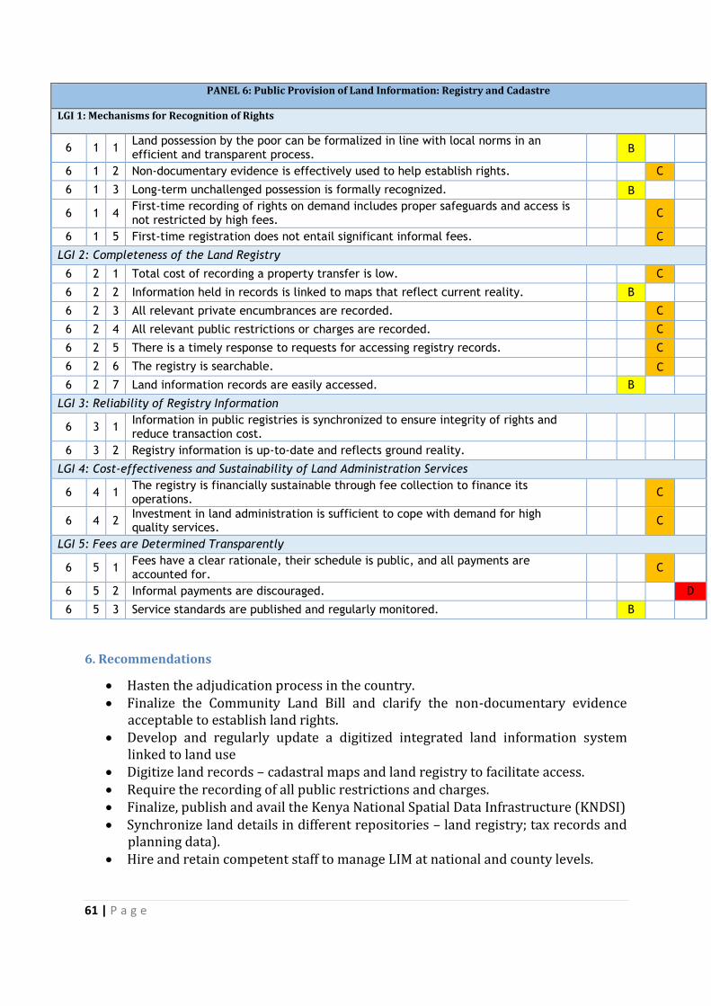
61 | P a g e
PANEL 6: Public Provision of Land Information: Registry and Cadastre
LGI 1: Mechanisms for Recognition of Rights
6 1 1 Land possession by the poor can be formalized in line with local norms in an efficient and transparent process.
B
6 1 2 Non-documentary evidence is effectively used to help establish rights. C
6 1 3 Long-term unchallenged possession is formally recognized. B
6 1 4 First-time recording of rights on demand includes proper safeguards and access is not restricted by high fees.
C
6 1 5 First-time registration does not entail significant informal fees. C
LGI 2: Completeness of the Land Registry
6 2 1 Total cost of recording a property transfer is low. C
6 2 2 Information held in records is linked to maps that reflect current reality. B
6 2 3 All relevant private encumbrances are recorded. C
6 2 4 All relevant public restrictions or charges are recorded. C
6 2 5 There is a timely response to requests for accessing registry records. C
6 2 6 The registry is searchable. C
6 2 7 Land information records are easily accessed. B
LGI 3: Reliability of Registry Information
6 3 1 Information in public registries is synchronized to ensure integrity of rights and reduce transaction cost.
6 3 2 Registry information is up-to-date and reflects ground reality.
LGI 4: Cost-effectiveness and Sustainability of Land Administration Services
6 4 1 The registry is financially sustainable through fee collection to finance its operations.
C
6 4 2 Investment in land administration is sufficient to cope with demand for high quality services.
C
LGI 5: Fees are Determined Transparently
6 5 1 Fees have a clear rationale, their schedule is public, and all payments are accounted for.
C
6 5 2 Informal payments are discouraged. D
6 5 3 Service standards are published and regularly monitored. B
6. Recommendations
Hasten the adjudication process in the country. Finalize the Community Land Bill and clarify the non-documentary evidence
acceptable to establish land rights. Develop and regularly update a digitized integrated land information system
linked to land use Digitize land records – cadastral maps and land registry to facilitate access. Require the recording of all public restrictions and charges. Finalize, publish and avail the Kenya National Spatial Data Infrastructure (KNDSI) Synchronize land details in different repositories – land registry; tax records and
planning data). Hire and retain competent staff to manage LIM at national and county levels.
62 | P a g e
G. Land Valuation and Taxation
1. Context for Land Valuation and Taxation Governance
Land value tax involves valuation of property, assessment or imposition of rates and collection of the tax or rate imposed. 46Land valuation and taxation is a critical component of land management and governance. According to a 2001 World Bank paper, property rates in Kenya provided an average of 20 percent of the total recurrent revenues for local authorities (now under Counties) and represent one (1) percent of the total government tax and 0.25 percent of GDP. As at 2001 property rates accounted for 34 percent of total own source tax revenue for municipalities and only 4 percent of own source revenue in towns and counties. The property tax is therefore an important revenue source for County and national government hence the need to ensure it is properly managed to ensure optimum benefit to the national and sub-national governments. Land valuation is a process of assessment of the price that a property would exchange in the open market assuming an arms-length transaction where all parties are acting prudently. For land taxation purposes the valuation process enables computation of an amount that is then used to compute the amount of tax payable. In Kenya, the tax payable is a percentage set by the national or county government annually and is applied on the value of the property. Land valuation for taxation purposes has been undertaken in Kenya since colonial days. Land taxation is carried out at two levels, national government and county (sub-national) government. Following the promulgation of Kenya’s new Constitution in 2010 and elections in 2013, the County Government took over from the former local authorities who comprised city, municipal, town and county councils. There are two main land taxes imposed in Kenya which are based on valuation figures. These are Land Rates and Stamp Duty. Rates are levies imposed by the County Government on all land classified as rateable mainly in urban areas and urban fringes. Rural and agricultural land is largely not subjected to rating tax although there is no law that prohibits levying rates. Stamp duty is a tax imposed on most property acquisitions either through purchase, inheritance, lease or any other transfer of interests in property. The value of the property is assessed by Valuers on a property to property basis or on values derived through zonal assessments. Other land based levies are land rent, development fees, and royalties. From January, 2015 Capital Gains Tax introduced in January, 2014 is also be applied to all property transactions. Capital gains tax is computed on the additional value of the property net of the cost of initial acquisition and costs incurred to improve the property. Land valuation and taxation plays a major role in land governance. Efficient service
delivery and economic development is also based on a land valuation and taxation
process that is all-encompassing, easily understood, fair and easily accessible to tax
payers. The Kenya Local Government Reform Programme was launched in 1998 to
spearhead local government reforms for good governance, efficient service delivery and
local economic service delivery (KLGR, 2010). The effect of this programme on land
46 C. Kanjama, Urban Land Value Taxation in Kenya: A case for Reform? LLM Draft Thesis. 2006

63 | P a g e
governance and the role of valuation and taxation in efficient service delivery are yet to
be assessed.
Kenya has an adequate legal basis for land valuation and taxation as will be seen below.
The primary problem is weak administration. While the law provides flexibility in tax
base definition, tax rate structures, valuation techniques, assessment, billing, collection
and enforcement, County governments’ have not followed the laid out process leading to
challenges in preparing valuation rolls. Property tax reform strategy was carried out
under the Kenya Local Government Reform Programme (KLGRP) that ended in 2012.
This does not however seem to have led to better land valuation and taxation
governance systems and tax collection and tax law enforcement is still a challenge.
Transparency and accountability in land valuation and taxation are also challenges.
Property owners do not know what valuation approaches are adopted and the rationale
behind the variables considered. This leads to doubts regarding the objectivity and
fairness of the valuation process. Property owners also question the basis of land
taxation on the basis of equity and justifiability and will not voluntarily comply.
The justification for levying of taxes by a government agency is based on the police
power of the state47 and its duty to provide public goods. Revenue collection is linked to
service provision. This link is not apparent as there is hardly any report given by
government agencies outlining how taxes collected are used to provide services and
which services were provided. The link between taxation and service provision and
associated efficacy needs to be examined and highlighted to facilitate an assessment of
the value for money and to imbue accountability in the tax collection process.
The tax rate can be set either as a per unit rate in the case of area rating or as per value
rate in the case of valuation rating. The unit area of the value rate can be either uniform
or differential. The differential rates can either be proportional or graduated based on
land use, value, or size. Local authorities are allowed to choose a valuation rate of up to
four percent without national government approval. The Cabinet Secretary in charge of
Devolution must approve all tax rates higher than 4 per cent as a precautionary measure
to protect the interest of the taxpayers. Generally, County Governments in Kenya tend to
use uniform area rate or a uniform tax rate structure. The tax rates range from 2 to 25
percent applied to the values contained on the valuation rolls. Those jurisdictions with
the higher tax rates tend to be those with oldest valuation rolls. Only a few County
governments apply a classified tax rate structure. The most notable is Mombasa, which
differentiates tax rates by location: properties located on the mainland and those in the
island. Nairobi City Council also uses differential rates based on land use: residential,
commercial and industrial.
The tax rate used is correlated with the age of valuation roll being used. Typically, the
valuation rolls are dated. Therefore, to compensate for the lag in revelations, the
government has allowed the County Governments to increase nominal tax rates. In
47 Article 66 of the Constitution
64 | P a g e
Nairobi, for example, the tax rate for residential property increased from 2.25 percent in
1982 to 5 percent in 1991 and to 34 percent in 2014. This increase has almost equalled
the rate of inflation thereby holding the average real tax burden per residential property
almost constant over the past 32 years. While there are provisions on exemptions, the
level of discretion allowed makes the process susceptible to abuse. For example in 2004,
there were reports in the local dailies that the then minister of Finance had waived
payment of stamp duty by a fellow cabinet colleague on a property transfer to his
company. This is among many unreported transactions where exemptions are indicated
to have been given without objective criteria. There should be clear provisions on
exceptions ad exemptions to minimize the exercise discretionary powers.
The draft Land Use Policy has provisions that may address some of the challenges. It
provides that land tax will be paid by owners of freehold land, and rent by the
leaseholder. It further provides that in the valuation of land for land tax, in addition to
the usual agricultural, mineral or settlement potential of the land, factors such as the
land’s environmental services should be considered. A framework with therefore need
to be developed to generate a system to value environmental services.
To address the issue of land administration, registration and dissemination of
information in relation to land transactions the policy indicates that the national
cadastre shall be linked to the national land tax and rent database to ensure that all
users of land make their annual contributions for the use of the land. On access by the
public, the policy provides that the national cadastre shall be open to the general public
to guarantee the transparency of land transactions and the land tax.
2. Transparency of Valuations
In Kenya, the Rating Act Cap 267allows the County authorities to tax either land or land
and improvements. Although the first application of “Rating” in Mombasa in 1921 was
based on land and improvement, all property rates in Kenya are currently levied only on
land. Improvements like buildings and other structures are not taxed. Furthermore most
County authorities exclude freehold land, agricultural land that is less than 12 acres, and
indeed most private land in the area rating rolls (KLGR, 2010). Public land (both
national government land and County government trust land) which is not yet titled is
also excluded from the private valuation roll, although technically this land should be
listed on the public valuation roll and be liable for Contribution in Lieu of Rates. In
addition, allocated County Government trust land not yet registered is not liable for
either rates or Contributions in Lieu of Rates.
The forms of rating allowed in the Rating Act are area rate, agricultural rental value rate
and site value rate or site value rate in combination with improvements. Although
variation in rating is allowed under the law, in practice, all sub-national authorities limit
their assessment to area rating and valuation based rating. Area rating tend to be used
65 | P a g e
for rural or agricultural properties while valuation based rating tend to be used for
urban property.
The fiscal cadastre information can be broken down into two components: First, there is
a valuation roll that contains land information and values for properties taxed under an
ad valorem rate. This valuation roll is broken into the private valuation roll and public
valuation roll and mainly covers only land located in the established gazetted area of
County government (former County Councils) urban centres. Second, there is property
tax information that is used for area rating purposes for land outside the gazetted area,
town and municipal council. This information covers the peri-urban areas that are taxed
under a system of area rating roll and can contain both private and public land. It is used
primarily for government forests and large farms. Rural agricultural land, if included in
the tax roll, is taxed on the area basis while urban land is taxed on an ad valorem basis.
Land tax assessment is the responsibility of the local authority which must identify a
valuer either a County employee from the Ministry of lands or from the private sector to
prepare the valuation rolls. The valuer is responsible for gathering the necessary
information, ascertaining a value, and producing the valuation form for the local council
then tabling the valuation roll, informing the public, and handling objections. The
valuation is then certified by the County and used for taxation purposes. The land tax in
Kenya is based on the market value of the un-improved site. The Valuation for Rating Act
indicates that market value is the sum which the land or unimproved property might be
expected to realize at the time of valuation if offered for sale on such reasonable terms
and conditions as a bona fide seller might be expected to impose, due regard being had
not only to that particular land but also to other land of similar class, character or
position and to other comparative factors and restrictions. Simply stated, the basis is
market value is what a property would exchange based on a willing buyer willing seller
exchange with a reasonable marketing period. This approach assumes there are
functional and active property markets. In Kenya, valuers assess the capital market
value of land. This requires gathering and managing information, assessing the
relevance and accuracy of that information and applying various methods to derive the
value. The Valuation for Rating Act Chapter 266 provides that in arriving at the value of
land, the Valuer may adopt any suitable method of valuation.
County Governments do not have the capacity to systematically maintain and coordinate
their fiscal cadastre information. With the exception of Nairobi, Mombasa, Nakuru and
Kisumu, County Governments depend on the rating department under the ministry of
lands to create and update their valuation rolls. This state of affairs is about to change as
County governments have started hiring their own Valuers. Kiambu County for instance,
recruited Valuers in February 2016.48 This notwithstanding, at present, all fiscal
cadastre information is maintained on manual basis. Moreover, the uniqueness of each
48 Information from one of the hired Valuers.
66 | P a g e
property places a strain on the number of personnel required. Though computerization
of the valuation process has been suggested as a solution, this also requires additional
technical capacity. Valuation rolls were to be prepared every five years but this was
changed to every ten years in 1991. However, the law provides for the production of
supplementary tax rolls on an annual basis as required but the valuation rolls are not
kept up-to-date. Many valuation rolls date back to early 1980s, with sporadic and ad hoc
issuance of incomplete supplementary valuation rolls. Nairobi City for example, uses a
valuation roll from 1982, accompanied by annual supplemental rolls. The former
Nairobi City Council prepared and updated the valuation roll but due to objections, the
new roll was not adopted forcing it to continue to rely on the 1982 valuation roll.
Objections to values returned has made valuation for rating in Nairobi a mechanical
process where Valuers use the values of the land in a particular part of the city as the
basis for assessing value of newly rateable property resulting from sub-divisions or
allocation. The value computed is then reflected in preparing Supplementary Valuation
Rolls. The 1982 valuation figures when applied to newly registered property cease to be
a valuation but application of an area valuation rate as values of specific properties have
changed over time but remain fixed to old rates applicable to the general area.
Stamp duty on both developed and undeveloped land in Kenya is assessed as a
percentage of the market value. Property within classified urban areas’ boundaries is
charged at 4 percent of the market value while property in rural and agricultural areas is
charged at 2 percent of the market value. This percentage is set by the Cabinet Secretary
in charge of Finance. The Minister can also exempt an entity from paying the tax.
Valuation for Stamp duty purposes is governed by the Stamp Duty Act Chapter 480,
Laws of Kenya, and is applied to developed and undeveloped land upon transfer. The
valuation is undertaken mainly by Valuers from the Ministry in charge of Lands. The
Stamp Duty is collected by Kenya Revenue Authority. The value is assessed using the
three principal valuation approaches, namely, the Income approach, the Cost approach
and the Sales Comparison approach. Each of these approaches simulates the thought
process of participants in the real estate market in a property exchange transaction to
arrive at market value.
The national government has Valuers both at the capital city and in some counties. Due
to inadequate valuation staff at the County level, one Valuer may be tasked to cover two
or more Counties. This challenge has necessitated the use of what are referred to as
zonal values determined from time to time. These zonal values are frequently dated due
to lack of capacity to carry out frequent property value assessments. Moreover, use of
zonal values is only applicable to undeveloped land. Developed properties are unique in
many attributes and require specific inspection and assessment by a Valuer to
determine the market value.

67 | P a g e
Valuation approaches are fairly well established and there are many Valuers in Kenya
who can be utilized to carry out valuation for taxation purposes. Challenges, however,
exist in funding the valuation exercise by both national and sub-national governments.
This challenge can be covered through improved land tax collection. The financial
challenges of hiring or engaging valuers can also be overcome by pursuing innovative
valuation, banding and computerized approaches. Valuation for taxation can also be
undertaken competitively and affordably by private valuers.
Kenya Valuers mainly undertake non-rating valuation activities owing to the relative
lack of contracts for doing valuation rolls. Kenya also does not use any form of mass
valuation, thus making the valuation process both costly in terms of time and resources.
Most property records are kept manually and maintained in an ad hoc and periodic
manner. The legal basis to ensure an up-to-date and complete valuation roll is adequate
but the problem is administration which is hampered by objections from property
owners.
The Kenya Local Government Reform Programme (KLGRP) mass valuation pilot project
was carried out in Mavoko and Nyeri Municipal Councils.49 This was under the KLGRP
established in 1998 to spearhead local government reforms for good governance,
efficient service delivery and local economic development. The results showed that it
would be possible to shift from the current single parcel approach to a simpler, more
cost effective mass appraisal approach. However, the work on property tax revealed that
the major obstacle to improved property rates is not valuation but poor administration
and lack of political will for collection and enforcement.
Valuations for land taxation are undertaken by valuers following instructions issued by
national or sub-national government agents. Valuation is based on clear principles as
prescribed by International Valuation Standards and Institution of Surveyors of Kenya
Handbook. These principles are applied to each property consistently. Valuers in Kenya
are also regulated by the Valuers Registration Board and the Institution of Surveyors of
Kenya. There is however need to ensure that the process of assessment of land values is
clear to all affected and all stakeholders. Moreover, valuation rolls should be regularly
updated, preferably every three years.
The process followed in fixing and revising land valuations is stipulated by law with the
procedure clearly prescribed and the process for handling any objections set out. The
County Government identifies a Valuer who prepares the valuation roll. Once the
valuation roll is adopted it is used for taxation purposes. Valuation figures are then
49 I. Blore et al , Municipalities and Finance; A Sourcebook for Capacity Building, Earthscan (2004); Vincent K. Kiptoo Land Governance and Accountability Framework – Kenya, Expert Investigator Report, October 2015
68 | P a g e
revised when a new Valuation Roll is prepared. Though the law is clear on the process of
fixing and revising valuations, members of the public are not fully sensitized and
empowered to engage in the process.
The use of rates clearance certificates for consent to transfer to be given is viewed as
problematic. Lack of transparency and accountability in the land taxation and valuation
processes hence creates discretionary practices leading to corruption. Valuers may be
compromised to reduce values of property or in Stamp duty valuations of developed
property not to report and value developments. Decision makers may be compromised
to waive taxes or to avoid severe enforcement mechanisms.
Any person may inspect the valuation roll. However, tax payers are not sensitized on
accessibility. Moreover, the valuation rolls are poorly kept making them inaccessible.
There should be clear provisions on public accessibility of valuation rolls and the mode
and media for storage and accessibility. The valuation rolls are poorly maintained and
are in a deplorable state that inhibits their potential use by members of the public.
Valuations are also not updated regularly.
3. Collection Efficiency
Property tax administration is the responsibility of both the National and County
Governments with the latter responsible for the collection of rates and the former for
stamp duty collection through the Kenya Revenue Authority. County Governments are
responsible for the construction and maintenance of tax roll, the valuation, the
assessment, tax billing, collection, enforcement, appeals and taxpayer services. While the
County Government can use in-house staff, other government departments such as the
Ministry of Lands or the private sector to assist in the performance of these functions,
most County Governments rely on the Ministry of Lands for the production of the
valuation rolls, with only a few using private sector Valuers.
The number of properties assessed for taxation in Kenya is still limited. For example
Nairobi City recorded rateable property is estimated to be about 60 percent of existing
properties in the City. The fiscal cadastre information and the valuation rolls in Kenya
are neither up-to-date nor completed. It is estimated that the fiscal cadastre and
valuation rolls may only include between 20-70 percent of the total taxable land. These
registries tend to be incomplete and out of date not due to the lack of trained valuers in
Kenya but rather due to lack of proper incentives and the reliance on individual “single
parcel” valuation. There is therefore need to focus on ensuring complete coverage of all
rateable properties within jurisdiction of either the national or sub-national government
based on appropriate fiscal cadastre. The KLGRP conducted two pilot projects to test a
simple and cost-effective field methodology for collecting property information required
to extend the tax base, ensure a more complete coverage and developing a computer-
assisted mass valuation model. The field data collection techniques for constructing and
maintaining the property rates fiscal cadastre information was conducted in Mavoko
Municipal Council. This pilot study enabled the refinement of the field data collection

69 | P a g e
procedures and confirmed that the current rates’ rolls were missing many properties.
Improving the coverage of the valuation roll to ensure that all properties are captured
and assessed is still a challenge.
The record of property liable to rates has been observed as inadequate and covers on
average about 50 percent of rateable properties. This means that tax rolls in Kenya are
still inadequate. Furthermore, assessed property taxes are not fully collected as the
enforcement mechanisms are weak and inefficient. Mechanisms should be put in place
to create an environment where liable property owners voluntarily comply.
Tax administration is the weak link of property taxation in Kenya. In general, the
revenue base information is incomplete, collections are low and enforcement is virtually
non-existent. The basic policy guidelines provide a flexible framework for an effective
property tax base system. Collection rates range from 5-60 percent of liabilities which is
attributed to lack of Taxpayer confidence or understanding of how tax is levied,
collected, enforced and used.
Though there are a variety of options under the Rating Act, the County Authorities have
taken a largely passive role in enforcement, relying almost exclusively on the rate
clearance certificates. This clearance certificate option relies on taxpayer initiative to
clear outstanding debt and is thus only effective when the property is being transferred
or when the local business license or permit is being requested from the County
Government.
Active enforcement through fines, tax, liens and foreclosure by the government is
minimal. Several county Authorities such as Nairobi and Mombasa occasionally publish
the names of delinquent taxpayers in the newspaper. Other Sub-national governments
initiate court cases against delinquent tax payers, with mixed results. To date no County
authority has applied the legal option of tax caveat to titles or foreclosed property as a
means to enforce tax payment. To improve tax compliance, political will must be
mobilized, administrative systems rationalized and improved, and local officials made
aware of the legal and procedural provision for enforcement.
For stamp duty, assessed taxes have to be paid before the transfer of property is
registered. Unconfirmed reports, however, indicate that in some instances corrupt land
registration officials collude with proper owners to avoid paying assessed taxes.
Moreover, there have also been allegations that Valuers are influenced to lower the
values of property to reduce the amount of tax payable. While land taxes collected are
undoubtedly used to pay for costs of collection, there is no record on any assessment to
gauge the relationship between receipts and cost of collection. The land tax authorities
should put in place mechanisms for assessing the cost of collection Vis a Vis the tax
collected to gauge value for money.
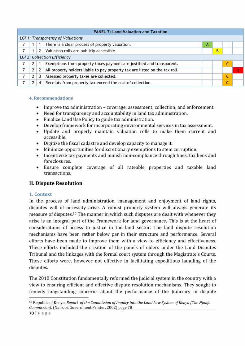
70 | P a g e
PANEL 7: Land Valuation and Taxation
LGI 1: Transparency of Valuations
7 1 1 There is a clear process of property valuation. A
7 1 2 Valuation rolls are publicly accessible. B
LGI 2: Collection Efficiency
7 2 1 Exemptions from property taxes payment are justified and transparent. C
7 2 2 All property holders liable to pay property tax are listed on the tax roll. D
7 2 3 Assessed property taxes are collected. C
7 2 4 Receipts from property tax exceed the cost of collection. C
4. Recommendations
Improve tax administration – coverage; assessment; collection; and enforcement. Need for transparency and accountability in land tax administration. Finalize Land Use Policy to guide tax administration. Develop framework for incorporating environmental services in tax assessment. Update and properly maintain valuation rolls to make them current and
accessible. Digitize the fiscal cadastre and develop capacity to manage it. Minimize opportunities for discretionary exemptions to stem corruption. Incentivize tax payments and punish non-compliance through fines, tax liens and
foreclosures. Ensure complete coverage of all rateable properties and taxable land
transactions.
H. Dispute Resolution
1. Context
In the process of land administration, management and enjoyment of land rights,
disputes will of necessity arise. A robust property system will always generate its
measure of disputes.50 The manner in which such disputes are dealt with whenever they
arise is an integral part of the Framework for land governance. This is at the heart of
considerations of access to justice in the land sector. The land dispute resolution
mechanisms have been rather below par in their structure and performance. Several
efforts have been made to improve them with a view to efficiency and effectiveness.
These efforts included the creation of the panels of elders under the Land Disputes
Tribunal and the linkages with the formal court system through the Magistrate’s Courts.
These efforts were, however not effective in facilitating expeditious handling of the
disputes.
The 2010 Constitution fundamentally reformed the judicial system in the country with a
view to ensuring efficient and effective dispute resolution mechanisms. They sought to
remedy longstanding concerns about the performance of the Judiciary in dispute 50 Republic of Kenya, Report of the Commission of Inquiry into the Land Law System of Kenya (The Njonjo Commission), (Nairobi, Government Printer, 2002) page 78
71 | P a g e
resolution (time, cost and fairness) and were premised on the role of judiciaries in the
dispensation of justice and the realization of the rule of law. By the time of the adoption
of this Constitution, citizen’s confidence in the Judiciary to resolve any manner of
dispute was low. The expression of this state of affairs is evidenced from the many task
forces that had been established over the years to investigate the Judiciary and propose
reforms, the bad blood between the Judiciary and citizens during the clamour for a new
Constitution as demonstrated by the Judiciary going to court to stop inclusion of
provisions on the Judiciary in the draft Constitution.51 The lowest point was the 2007-8
Post-Election violence following the disputed Presidential elections, when the Parties to
the dispute refused to refer their matter to the Judiciary for resolution with one side
seeing the Judiciary as partisan and compromised.
The Constitution has sought to restore the place of the Judiciary in the governance
arrangements of the country. It provides that judicial authority derives from and has to
be exercised for the benefit of the People of Kenya and gives guidelines on how the
power has to be exercised including the requirement for equal treatment, focusing on
substantive justice, avoiding delay and incorporation of alternative and traditional
mechanisms of dispute resolution. In the specific context of land disputes, it has created
a specialized court, the Environment and Land Court to hear and determine disputes
relating to “environment and the use and occupation of, and title to land.”52 The court
has been established but it is overwhelmed because all land cases, the bulk of civil cases
before the courts, were transferred to it and there are not enough judges to handle the
volume of cases. There are initiatives to increase the number of judges. Before the
enactment of the 2010 Constitution, the country adopted the position that land disputes
should at the first instance be resolved away from courts. Instead elders were
empowered to listen to disputes arising in their immediate community.53 This led to the
establishment of Land Disputes Tribunal. However, the system failed due to the
relationship between the tribunals and the courts. While Magistrate’s courts were
supposed to recognize and register the decisions of the tribunals, in reality they ended
up operating parallel systems with most people dissatisfied with their decisions ending
up in court.54 This was exacerbated by the fact that the bulk of these tribunals were ill
equipped on legal aspects of the disputes they were handling. In addition, land that was
registered was outside their jurisdiction. By the time that the Environment and Land
Court Act was enacted to replace these tribunals, their performance was already a
subject of concern and many had ground to a halt due to amongst other things expiry of
the term of their members, lack of adequate finances and unhealthy relationships with
51 Judges Moijo Ole Keiwa and Juma Odero went to Court seeking an injunction to stop the inclusion of constitutional reforms to radically transform the judiciary in 2002 52Article 162 (2) (b), Constitution of Kenya, 2010. 53Kibwana, K.,” Efficacy of State Intervention in Curbing the Ills of Individualization of Land Ownership in Kenya,” in Wanjala, S.C., Essays on Land Law: The Reform Debate in Kenya (Nairobi, University of Nairobi, 2000) pages 179-191 at 186. 54 Personal experience with the tribunals
72 | P a g e
ordinary courts. Ordinary courts were also ineffective in resolving land disputes due to
delays and corruptions. Land cases took a long time to go through the court system and
the problem of backlog was and remains a source of concern in the judiciary. Besides
backlog, corruption in the judiciary had escalated to such heights that there was a saying
going round that you did not need to pay a lawyer when you could buy the judge.55
The report of the Njonjo Land Commission captured the citizens’ mood and status of
land dispute resolution mechanisms thus:
The public has lost faith and confidence in the existing land dispute settlement
mechanisms and institutions, because they are characterized by delays,
incompetence, corruption, nepotism, political interference and overlap of roles
and functions leading to conflict, confusion and unnecessary bureaucracy
especially when there is a low participation of the local people in land dispute
resolution mechanisms.56
For the above reason the National Land Policy proposed reforms in the system,
structures and processes for resolving land disputes. Its focus was to ensure timely,
efficient and affordable dispute resolution mechanisms so as to facilitate efficient land
markets, tenure security and investment stability in the land sector. The National Land
Policy proposed the establishment of independent, accountable and democratic systems
to adjudicate disputes at all levels; appropriate and inclusive institutions for dispute
resolution and improvement of their operational and record keeping procedures; and
use of alternative dispute resolution mechanisms.57 The Policy also called for the repeal
of the Land Disputes Tribunal Act of 1990 to be replaced with a more appropriate
legislation for dispute resolution at the district and community level in addition to
having land disputes to be resolved by a land division of the High Court.58
2. Dispute Resolution Mechanisms: Assignment of Responsibility
The current land dispute resolution mechanisms are captured in the Constitution of
Kenya, 2010 and include:
Judiciary (The Environment and Land Court)
Alternative Dispute Resolution mechanisms
Traditional Dispute Resolution Mechanisms
National Land Commission
National Environment Tribunal
Public Complaints Committee on the Environment
55 P. Kameri-Mbote & M. Akech, Kenya: Justice Sector and the Rule of Law, A review by AfriMAP and the Open Society Initiative for Eastern Africa, Open Society Foundations (2011) 56 Supra, note 1 at page 78 57 Republic of Kenya, Sessional Paper Number 3 of 2009 on National Land Policy (Nairobi, Government Printer, Nairobi, 2009), page 42. 58 See Ibid, Page 62

73 | P a g e
The Judiciary still remains the main form of resolving land disputes. Unlike the situation
obtaining before the passage of the new Constitution, land disputes are now handled by
a specialized court, the Environment and Land Court. The Court is established by virtue
of the Constitution at the same status as the High Court. While it is not the High Court,
the interpretation of this provision is that it has similar powers in its area of
specialization as the High Court. In environment and land matters, the jurisdiction of the
Court ousts that of the High Court, meaning that the normal High Court cannot entertain
a land dispute. In terms of structure, the Court is expected to exist and operate across
the entire country. In accordance with the Judicial Service Act, this would require that
such a court be established in every County. Following the enactment of the
Environment and Land Court Act in 201159, The President on the recommendation of the
Judicial Service Commission appointed the first batch of environment and Land Court
Judges. Currently there are twenty judges of the Environment and Land Court in Kenya.
These cover only sixteen stations across the country, with the consequence that thirty-
one counties do not have designated environment and land court judges to hear these
matters. This is particularly important when viewed against the question of Jurisdiction
and the importance and number of land disputes in the country. In Kenya, where the
majority of the people rely on land for the livelihoods, every county has a land dispute
that requires the services of an Environment and Land Court. It is therefore necessary as
a survey by the Land Development and Governance Institute reported in December
201460 that an Environment and Land Court be established in each of the remaining 31
counties so that the courts can exists in all of the county’s forty seven counties. In
addition consideration should also be given to increasing the number of judges per
station owing to the magnitude of cases that these courts are faced and will continue to
handle in the future.
The second aspect of the Court’s operations that has been problematic relates to its
jurisdiction. From the time of its establishment questions arose regarding the
jurisdiction of the Court, its relationship with the High Court, jurisdiction regarding
criminal cases and link with and jurisdiction of subordinate courts and tribunals over
land matters. The overall guide on the question of jurisdiction is Article 162 (2) (b) of
the Constitution which provides that the Court shall have jurisdiction over matters
relating to the environment and use and occupation of and title to and. This is further
clarified by Section 13 of the Environment and Land Court Act. It lists the matters that
the court is competent to handle to include:
environmental planning and protection, climate issues, land use planning, title,
tenure, boundaries, rates, rents, valuations, mining, minerals and other natural
resources;
59 Chapter 12A, Laws of Kenya. 60 Land Development and Governance Institute, An Assessment of the Performance of the Environment and Land Court, 2014. Available at http://www.ldgi.org/index.php/media-centre/reports-and-publications/38-ldgi-12th-scorecard-report-assessment-of-the-environment-a-land-court/file.
74 | P a g e
compulsory acquisition of land;
land administration and management;
Public, private and community land and contracts, choses in action or other
instruments granting any enforceable interests inland.
There is an ongoing debate on whether judges of the Court are part of the High Court
subject to administrative movement by the Chief Justice or whether their appointment is
exclusively to this court. The Judiciary has adopted the position that a judge of the
Environment and Land Court can handle any other matter that a high court judge has
jurisdiction handle. This has influenced the action by the chief Justice to designate a
Presiding judge for this Court from the High Court judges and to allocate members of the
Environment court general matters that are not environmental. While these actions
have on occasion responded to practical exigencies, they deviate both from the letter
and the spirit of the Constitution and the rationale of establishing the court as a
specialized court. The land cases continue to be lodged and with few judges in the Court
subject to deployment to handle other matters, the backlog of land cases may continue
to increase while others decrease.
The other jurisdictional issues that have arisen related to whether the court could deal
with criminal matters and the jurisdiction of magistrate’s courts over land cases.
Regarding the latter the law that establishes the Courts on the one hand only gives it
civil jurisdiction, yet at the same time allows it to deal with disputes under EMCA. EMCA
includes provisions of environmental offences and one can argue that these should also
be dealt with by the Environment and Land Courts. The last question has focused on the
continued handling of land matters by magistrates’ courts. While the Environment and
Land Court Act gave the courts original and appellate jurisdiction over environment and
land matters it originally did not address itself to magistrate’s courts hearing land cases
a situation that led to congestion and delays in disposal of cases. An amendment to the
Act has since granted magistrate’s courts powers to hear and determine land cases.
3. The Share of land affected by pending disputes
In terms of Performance, the Judiciary has, as part of implementing its Judicial
Transformation Framework, focused on reducing case backlog by having special
sessions to clear cases that have stayed for too long within the judicial system. In its
Annual report for 2012/2013, the Judiciary reported that it had 16,407 pending cases,
majority of which had been inherited from the civil Division of the High Court. 8,309
new cases were filed and 443 cases disposed of during the year. This shows that unless
the numbers of both courts and judges of the Environment and Land Courts are
increased, delays in handling environment and land matters are likely to continue.
The Judiciary report for 2012/2013 indicates that the of the cases filed in that year
land matters accounted for close to 14 percent of the cases, while the total cases pending
before the judiciary included 10% land cases. On a positive note, while there is still case
75 | P a g e
backlog, the judiciary has in recent years focused on long-standing disputes. This has led
to the reduction in the number of cases that have taken a very long time, like ten years to
conclude. In the Month of January 2015, the Chief Justice appointed a panel of ten judges
under the initiative dubbed justice@last to listen to old civil cases and determine the
bulk of them, which process resulted in clearing of many old cases.
With the enactment of the Environment and Land Court Act in 2011, the Land Disputes
Tribunals that listened to land cases throughout the country relying on the Provincial
Administration and a panel of elders ceased to operate with matters they handled being
taken up by the Court. The only tribunal that continued to exist is the National
Environment Tribunal whose mandate is exclusively environment matters and is
relevant only to the limited extent that there is a close nexus between and environment.
In determining environment matters, certain land issues can also be brought before the
tribunal.
4. Alternative Dispute Resolution Mechanisms
The Constitution recognizes alternative mechanisms for resolving disputes and includes
it as part of the judicial system. Article 60 on principles of a National Land Policy
specifically urges reliance of traditional mechanisms in resolving land disputes. The
Environment and Land Court Act also addressed alternative mechanisms including
conciliation, mediation and reliance on traditional dispute resolution mechanisms.
Traditional dispute resolution (TDR) mechanisms are especially relevant for Community
land hence the great focus on it in the Community Land Bill that is yet to be enacted into
law. Currently, there are many communities that are relying on TDR as a means of
resolving their disputes at the local level. It is important that a framework for
recognizing and operationalising these mechanisms as contemplated by the Constitution
is fast tracked. This is a task for the Judiciary but one which is also vested on the NLC.
In addition the provincial administration, especially the office of the Chief still continues
to resolve land related disputes. Even though the legal basis for such action is subject to
challenge, the reality is that they continue to provide citizens at the local level with a
quick and easy means of resolving certain land disputes.
The NLC is established by the Constitution to provide for the framework for
administering public land. It has wide responsibilities over all categories of land. Two
functions that are relevant for dispute resolution are those that relate to investigation of
complaints into present and historical land injustices and encouraging application of
traditional dispute resolution mechanisms. In reliance on these powers the NLC has
been involved in land dispute resolution. Its constitutive Act also gives it dispute
resolution functions. These latter ones however conflict with the role of the
Environment and Land Court and require to be amended.
While reforms have been undertaken in the process and structures for resolving land
disputes, there remain several areas of concern: traditional dispute resolution
76 | P a g e
mechanisms; numbers of environment and land courts; and jurisdiction. Access to
justice in land matters for poor and rural communities remains a mirage and there is
also need to speed up the disposal of land cases. The Judiciary in its State of the Judiciary
report for 2012/2013 acknowledges that land cases take a very long time, in fact the
longest time of the all the cases brought before the courts to finally dispose of.
The question of competence of judicial officers is one that the law made efforts to deal
with by requiring specialization for appointment to these courts. The initial
appointments by the Judicial Service Commission required expertise in land and
environment matters. The subsequent appointments sought to do away with this
requirement and leave the designation to be undertaken administratively after
appointment. The work of the Judicial Training Institute with its regular training
programmes is also a necessary addition to the competence enhancement of officers in
these courts. It is important that as they undertake their dispute resolution functions,
the courts also pay attention to gender.
Despite the recognition of traditional dispute resolution as a mechanism for resolving
land disputes and the constitutional requirement that communities be encouraged to
utilize it to resolve disputes, several decades of neglect has led to the near collapse of
many informal systems for resolving land disputes. The formal folding of the panel of
elders means that currently no recognized mechanisms exist at the local level. The
Community Land Bill with its dispute resolution provisions should be passed and a clear
framework for the operations of TDR across the country established.
Further, while the appeal process is clear, the ongoing reforms in the Judiciary have not
fully addressed the issue of costs and delays in disposal of cases. The process is however
ongoing. While there are ongoing reforms to address speed in disposal of appeals and
clarify the appeal structure, the cost of appealing to the court of Appeal is still high
making appeals unaffordable to rural poor and the majority of the citizens. With the
limited number of judges, less than 10% of the cases are determined within the year
they are filed.61 although the establishment of a specialized Environment and Land Court
has brought with it specialization in resolving land cases and was hoped to ensure faster
and effective disposal of cases, the lack of an Environment and Land Court in every
county, the few number of environment and land court judges reduces the speed within
which disputes are heard and determined. The Environment and land Court Jurisdiction
should also be reviewed.
61 Republic of Kenya, State of the Judiciary and Administration of Justice, Annual Report 2012/2013; Republic of Kenya, Judiciary Transformation Framework 2012-2016; and Land Development and Governance Institute, An Assessment of the Performance of the Environment and Land Court, 2014. Available at http://www.ldgi.org/index.php/media-centre/reports-and-publications/38-ldgi-12th-scorecard-report-assessment-of-the-environment-a-land-court/file.
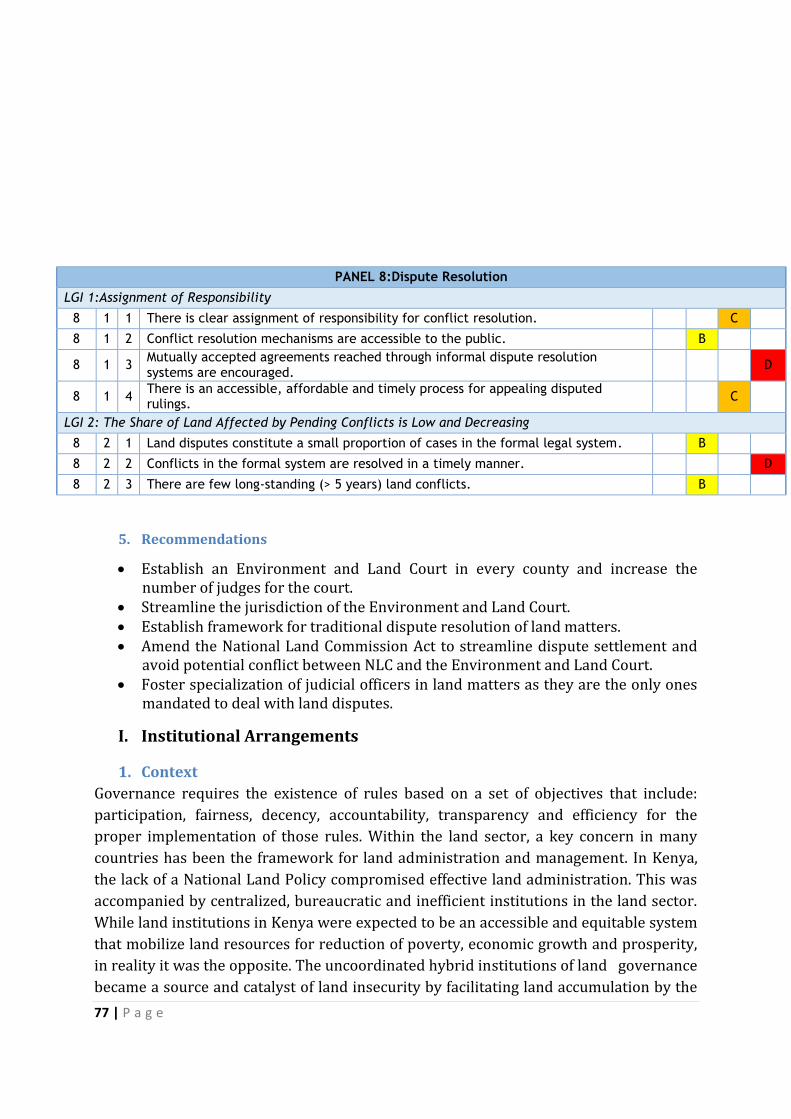
77 | P a g e
PANEL 8:Dispute Resolution
LGI 1:Assignment of Responsibility
8 1 1 There is clear assignment of responsibility for conflict resolution. C
8 1 2 Conflict resolution mechanisms are accessible to the public. B
8 1 3 Mutually accepted agreements reached through informal dispute resolution systems are encouraged.
D
8 1 4 There is an accessible, affordable and timely process for appealing disputed rulings.
C
LGI 2: The Share of Land Affected by Pending Conflicts is Low and Decreasing
8 2 1 Land disputes constitute a small proportion of cases in the formal legal system. B
8 2 2 Conflicts in the formal system are resolved in a timely manner. D
8 2 3 There are few long-standing (> 5 years) land conflicts. B
5. Recommendations
Establish an Environment and Land Court in every county and increase the number of judges for the court.
Streamline the jurisdiction of the Environment and Land Court. Establish framework for traditional dispute resolution of land matters. Amend the National Land Commission Act to streamline dispute settlement and
avoid potential conflict between NLC and the Environment and Land Court. Foster specialization of judicial officers in land matters as they are the only ones
mandated to deal with land disputes.
I. Institutional Arrangements
1. Context
Governance requires the existence of rules based on a set of objectives that include:
participation, fairness, decency, accountability, transparency and efficiency for the
proper implementation of those rules. Within the land sector, a key concern in many
countries has been the framework for land administration and management. In Kenya,
the lack of a National Land Policy compromised effective land administration. This was
accompanied by centralized, bureaucratic and inefficient institutions in the land sector.
While land institutions in Kenya were expected to be an accessible and equitable system
that mobilize land resources for reduction of poverty, economic growth and prosperity,
in reality it was the opposite. The uncoordinated hybrid institutions of land governance
became a source and catalyst of land insecurity by facilitating land accumulation by the
78 | P a g e
political elite to the detriment of ordinary Kenyans. Consequently, reforming land
institutions for effective and efficient land administration became a key component of
land reform in Kenya. The character of institutional arrangements and the distribution
of power in a management context is a crucial determinant of the efficacy of a system
and the possible implementation strategies that may be employed.62
In reforming land administration, the focus has been on ensuring that the institutions
foster effective land administration and governance. Land governance has to be viewed
not just as a techno-legal, procedural and political exercise, but a process where
decisions regarding access to and use of land are made in a participatory manner. It also
addresses structures of institutions for implementing decisions and reconciling and
resolving conflicting interests over land.
The process of reforming the institutional architecture for land administration and
management was highlighted in the Njonjo Land Commission report, stressed in the
Ndungu land report, picked up in the National Land Policy formulation process and
addressed in both the Constitution making process and the enactment of new land laws.
It has continued to be one of the key sticking points in the governance of the land sector
with its public manifestation seen in the jurisdictional and operational conflicts between
the Ministry of Lands, Housing and Urban Development and the NLC. This is the basis
upon which the assessment of the institutional and policy review in the land sector is
undertaken.
Many policy documents on land reforms provide succinct summaries of the problems in
the land administration and management institutional structure. While there have been
numerous institutions administering and managing public land, there was lack of
coherence in the execution of their mandate, majority of them were obsolete, poorly
resourced (human, financial and capacity) and thus incapable of delivering the services
required effectively. None of the key land administration functions - juridical, regulatory,
fiscal, fiscal and cadastral services63 - was satisfactorily delivered by the existing
institutional architecture. Like in most African countries, the land administration system
in Kenya has been plagued by substantial disuse, bureaucratic complexity, managerial
opacity, general inefficiency and high transaction costs.64 The National Land Policy
noted on the land administration system that:
The existing institutional framework for land administration and management is
highly centralized, complex, and exceedingly bureaucratic. As a result, it is prone
to corruption and has not been able to provide efficient services. In addition, it
62 Ochieng, B. O.,”Institutional Arrangements for Environmental Management”, In Okidi, C.O., Environmental Governance in Kenya: Implementing the Framework Law, (East African Educational Press, Nairobi, 2008) 183-207 at 183. 63 Kenya Land Alliance, Efficacy of Establishing a National Land Commission for Land Administration in Kenya, (Kenya Land Alliance, Nakuru) 64Ibid, page 5.

79 | P a g e
does not adequately involve the public in decision making with respect to land
administration and management, and is thus unaccountable.65
The system failed to meet Kenyans’ expectations, a fact which they expressed both to the
Ghai led Constitutional review Commission process and the consultations by the Njonjo
Commission of Inquiry. To the ‘Njonjo Commission’, for example they complained that:
(T)he overall lack of policy, the destruction of infrastructure, the interference in
land matters by the Provincial Administration and most of all the failure to heed
the views and needs of the local residents has brought land administration into
total disrepute in the eyes of Kenyans. The Ministry of Lands and Settlement had
failed in most areas of land administration, planning, development and
protection. Instead some Ministry officials were involved in the destruction of a
sound and working system of land tenure, land ownership and land development.
The Ministry had failed to comply with the law or amend the law to cater for new
developments. Instead it had connived at and enabled a system of speculation
and land grabbing to flourish throughout the country. In its turn, the cavalier
attitude had brought the sanctity of title to land wholly into disrepute with a very
negative effect on the economy as a whole.66
The reforms that the country has implemented through adoption of the National Land
Policy, a new Constitution, and the enactment of the new land laws and the drafting of
National Land Use Policy have sought to address these problems by reforming the
institutional structure and systems for land administration and management. The
reforms seek to: facilitate delivery of efficient, cost-effective and equitable services;
ensure devolution of land administration and management; facilitate access to land
administration and management by the poor so that the sector can contribute to poverty
reduction; and ensure stakeholder participation and accountability.67
Before the adoption of the National Land Policy adopted in 2009 adoption, the country
had no comprehensive policy for the land sector and relied on sectoral policies like
Agriculture, Water and Wildlife policies. This resulted in a complex, bureaucratic and
uncoordinated management and administration framework. The Policy recognized that
Kenya’s tenure regimes are plural in nature and gave equal status to the three tenure
categories that it recognized- public, private and communal- and detailed guarantees for
securing tenure rights. These were subsequently included in the new Constitution
adopted in 2010. It also recognized the importance of clear institutional structures for
the sustainable management and utilization of land in Kenya and proposed that a
National Land Commission be established to perform some of the functions of land
administration performed by the Ministry responsible for land.
65 Republic of Kenya, Sessional Paper Number 3 of 2009 on National Land Policy (Government Printer, Nairobi, 2009) page 57 66 Ibid., page 105. 67 Supra, note 4 page 57.
80 | P a g e
2. Kenya’s New Land Institutions
Before the 2010 Constitution, the institutional structure for land administration
comprised of the Ministry of Lands as the overarching body. Other Ministries such as
agriculture, water, forest also created administrative tools to address some aspects of
land. At the local level there also existed the Land Dispute Tribunals and Land Control
Boards. While the enactment of the Environment and Land Court Act has resulted in the
repeal of the Land Disputes Tribunal Act, the fate of Land Control Boards which regulate
dealings in agricultural land still hang in the balance. Although parliamentary debate
during the passage of the Land Act and Land Registration Act sought to get rid of the
Land Boards, the Acts are silent on their fate.
Under the current legal and policy framework, the main land administration institutions
are:
The Ministry for Land, Housing and Urban Development
The National Land Commission
County Governments
County Land Management Boards
Proposed institutions under the Community Land Bill
Environment and Land Court
National Government Administrative officers
In addition to these there are several other ministries and departments that perform
functions relevant to land administration and management. These include:
Ministry of Agriculture
Ministry of Water and irrigation
Ministry of Energy
Ministry of Mining
Ministry of Environment and Natural Resources.
Under each of the Ministries above, there are also department and agencies with
functions that support land administration. The main ones include:
National Environment Management Authority
Kenya Forest Service
Kenya Wildlife Service
Water Resources Management Authority.
The institutional map outlined above also includes land owners, private sector and civil
society. Assessing the efficacy of land institutions in Kenya against the LGAF framework,
an effective land administration institutional framework has to meet three
prerequisites: clear definition of the rules for allocation of land rights, by allowing cost-
effective enforcement that encourages and facilitates land-related investments; reliable
information on land and property rights has to be freely available to interested parties;
and rules and regulation need to be in place to avoid negative implications that may
arise from uncoordinated actions by all interested parties.

81 | P a g e
Kenya has a National Land Policy which incorporates principles of fairness,
transparency and equity in the management of land and related resources. These
principles are also included in the Constitution at Article 60. The challenges with the
policy relate to its incongruence with certain parts of the Constitution and lack of full
and effective implementation. While the Policy was adopted in 2009 with very robust
provisions, by the time the Constitution was adopted a year later, several changes were
made in the manner in which the institutional architecture would be structured
including the functions of the NLC. The result has been contradictions and conflicts in
implementation. Absence of political will in implementing the Policy is also an issue.
With regard to functions of land institutions, progress has been made in both vertical
and horizontal distribution of functions. Generally the functions of policy formulation
are shared between the Ministry responsible for lands and NLC. Implementation is
shared between the counties, the national government and the NLC. Dispute resolution
which in the past was performed by both the courts and the executive (provincial
administration), has been streamlined and is now performed principally by courts and
traditional and alternative dispute resolution institutions.
Despite these clarifications, sharing of mandates has not been as harmonious as it could
have been due to institutional rivalry, overlaps and disharmony in the administration of
land. The Ministry of Lands and the NLC have had conflicts over which of them is to
perform certain functions over almost all aspects of land administration ranging from
who has the right to issue title deeds, survey functions, renewal of leases to who should
develop regulations to operationalise the land laws. The Advisory Opinion given by the
Supreme Court on this matter in November 2015 settled the issue of who has the role of
issuing titles in favour of the Ministry. The court however noted that NLC has a mandate
in various land registration and management processes but not in the issuance of title
deeds. The court further called on the Ministry and NLC to collaborate, co-operate and
consult each other on all land matters as they perform their various mandates as spelt in
the constitution.68
The operation of the land institutions has been affected by legal ambiguities and
persistent land problems. Around the country informal settlements and unplanned
developments are fuelling tenure insecurity reflective of weak land governance. The
expectation that a one-stop-shop as a single point of contact in managing land
administration processes and dealing with the necessary approvals for efficient service
delivery would be established has not materialized. The process is bogged down by
bureaucratic indecision.
Land institutions can only operate properly when the mandates, roles and
responsibilities of each of the hybrid institutions are clear, unambiguous and adhered to
68 http://www.standardmedia.co.ke/article/2000184276/supreme-court-national-land-commission-has-no-mandate-to-issue-land-title-deeds

82 | P a g e
as provided by policy and legal frameworks. In Kenya the vertical hierarchy between the
Ministry in-charge of land matters and the NLC has not worked well and this has
affected horizontal operations between other public agencies. It has also hampered the
intended process of factoring in the participation of other stakeholders. Consequently,
complaints of administrative ineptitude and corruption, overloaded courts,
indeterminate dispute resolution, and ineffective implementation of policy and laws
abound. The ultimate impact of this poor governance is poor service delivery.
There are ongoing efforts to deal with these challenges including computerization and
digitization of land records, court supervised efforts between the National Land
Commission and the National government to develop a working relationship, attempts
to amend the land legislation to enhance clarity in mandate amongst various land
administration agencies. These need to be accompanied by increased allocations of
resources to the land sector, improved service delivery and addressing corruption in the
land sector.
The reforms intended to separate policy formulation, implementation and arbitration
are on-going. There is lack of clarity in the law on the extent of the division of
responsibility between NLC and Ministry of Lands and lack of harmony and coordination
between the two which further blurs the separation of roles and powers. There should
be enhanced collaboration between NLC and Ministry of lands. The opinion of the
Supreme Court on functions of the Ministry and the NLC which both parties have agreed
to abide by is expected to address this problem.
Further land laws should be amended to provide clarity but even with clarity in laws,
interlinkages with and collaboration amongst land and related natural resources’
institutions is critical since complete separation is impossible. Despite Constitutional,
legal and policy provisions which clearly stipulate the roles of the NLC as the
Constitutional body with responsibility over management over public land and
oversight responsibilities relating to the land sector, the Ministry for lands with policy
functions, counties and sectoral line ministries also have some responsibilities and the
link between the different ministries and agencies creates overlaps. Dealing with the
oversight functions of NLC over sectoral agencies, like Kenya Forest Service and Kenya
Wildlife Service in land and natural resources’ issues in implementing sectoral
legislations has also resulted in several overlaps and ambiguities in vertical
relationships between these agencies and the NLC. These ambiguities in the roles and
relationships require to be dealt with through harmonizing the roles of all agencies in
the land sector and also encouraging inter-agency consultations and consensus on
collaborative relationships. While amendment of law may help to remove overlaps and
ambiguities, some problems are not amenable to resolution through legal amendment
and can better be resolved through good will and collaboration.
As noted above, most of the land information is still manual making access difficult. The
on-going digitization is set to improve access but it is still at its initial stages. There have

83 | P a g e
been previous efforts at digitization which have failed. Consequently, while land
information is collected and is available, it is not easily accessible.
Another area where institutional incongruences arise is in the area of the sub-soil and
renewable resources. The Constitution is clear about the categorization of land tenure
rights as the subsoil and renewable resources are categorized as public land. However
since they sit under land, the tenure of the topsoil differs according to the holdings. The
relationships between these two are problematic in law and practice. It is at the heart of
conflicts between communities, investors and also between national and county
government in areas where minerals, oil and other extractives have been discovered.
The laws on natural resources especially renewable ones need to clarify the links
between land rights and the rights to sub-surface resources. As noted above, while
changes have been instituted in the conflict resolution realm, there is still room for
improvement. Traditional dispute resolution mechanisms need to be applied to land
disputes in consonance with Constitutional requirements and the role of the
Environment and Land Court in resolving conflicts over tenure rights can be improved.
The levels of integration and coordination in dealing with land related matters are
generally weak. The example of the grabbing of land belonging to Lang’ata primary
school and the response of government demonstrates the lack of effective coordination
between the national and county government, and the overlaps between the roles of the
NLC, the Ministry of Lands and the police in dealing with land matters. The roles of
different agencies in the land sector require clarification and inter-sectoral coordination
and links need to be enhanced.
3. Equity and Non-Discrimination in the Decision-making Process
While the National Land Policy was adopted in a participatory manner the process of
implementation rarely follows the requirement for consultation and effective
participation. When consultations happen, citizens rarely get feedback on the extent to
which their views were adopted and for those not adopted why this was the case. A clear
legislative and policy framework for public consultations and feedback is needed.
The principles of land policy as captured in Article 60 of the Constitution and the
National Land Policy focus on equity considerations and also seek to eradicate
discrimination in land ownership, access and use. Poverty eradication is also an
objective of land reforms, hence the focus on productivity. In practice though the
realization of the equity and poverty objectives are not monitored consistently and
when they are, the process and outcomes are not published and publicized. There is
need to improve the monitoring of implementation of the land policy objectives and
targets and involve the public in the process.
The link between land and environment is best seen in the context of the principle of
sustainable development. The National Land Policy recognizes that one of the principles
to guide land management is sustainability and also the conservation and protection of
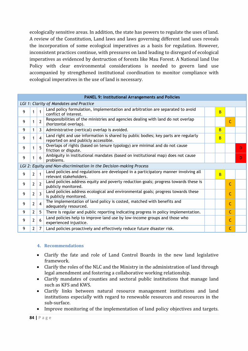
84 | P a g e
ecologically sensitive areas. In addition, the state has powers to regulate the uses of land.
A review of the Constitution, Land laws and laws governing different land uses reveals
the incorporation of some ecological imperatives as a basis for regulation. However,
inconsistent practices continue, with pressures on land leading to disregard of ecological
imperatives as evidenced by destruction of forests like Mau Forest. A National land Use
Policy with clear environmental considerations is needed to govern land use
accompanied by strengthened institutional coordination to monitor compliance with
ecological imperatives in the use of land is necessary.
PANEL 9: Institutional Arrangements and Policies
LGI 1: Clarity of Mandates and Practice
9 1 1 Land policy formulation, implementation and arbitration are separated to avoid conflict of interest.
B
9 1 2 Responsibilities of the ministries and agencies dealing with land do not overlap (horizontal overlap).
C
9 1 3 Administrative (vertical) overlap is avoided. B
9 1 4 Land right and use information is shared by public bodies; key parts are regularly reported on and publicly accessible.
B
9 1 5 Overlaps of rights (based on tenure typology) are minimal and do not cause friction or dispute.
D
9 1 6 Ambiguity in institutional mandates (based on institutional map) does not cause problems.
D
LGI 2: Equity and Non-discrimination in the Decision-making Process
9 2 1 Land policies and regulations are developed in a participatory manner involving all relevant stakeholders.
B
9 2 2 Land policies address equity and poverty reduction goals; progress towards these is publicly monitored.
C
9 2 3 Land policies address ecological and environmental goals; progress towards these is publicly monitored.
C
9 2 4 The implementation of land policy is costed, matched with benefits and adequately resourced.
C
9 2 5 There is regular and public reporting indicating progress in policy implementation. C
9 2 6 Land policies help to improve land use by low-income groups and those who experienced injustice.
C
9 2 7 Land policies proactively and effectively reduce future disaster risk. C
4. Recommendations
Clarify the fate and role of Land Control Boards in the new land legislative framework.
Clarify the roles of the NLC and the Ministry in the administration of land through legal amendment and fostering a collaborative working relationship.
Clarify mandates of counties and sectoral public institutions that manage land such as KFS and KWS.
Clarify links between natural resource management institutions and land institutions especially with regard to renewable resources and resources in the sub-surface.
Improve monitoring of the implementation of land policy objectives and targets.

85 | P a g e
VII. POLICY MATRIX Policy issue Proposed action Responsible
agency
Monitoring indicator
Recommendations on Panel 1
LG1: Recognition of continuum of rights
1 While law recognizes
the continuum of
rights and has
provisions recognizing
rights of communities,
secondary rights and
rights of women,
undocumented rights
are difficult to
establish as formal
ownership recorded in
documents is
privileged.
Finalize the Community land bill and the national land use policy and
synchronize land rights’ holding by providing a framework that protects
rural land owners from grabbing of their lands in the process of mapping
and recording of rights.
Need for safeguard measures to secure women’s rights, informal tenure
for communities using commons and recognition and protection of
indigenous values and institutions in rural land use.
Enhance technical and fiscal capacity of land governance institutions to
safeguard multiple rights including and handle irregularity and
corruption.
Given the flurry of legislating to align laws to the Constitution, Kenya can
benefit from reference to the FAO Voluntary guidelines on responsible
MoLHUD;
Parliament;
Civil Society;
traditional land
governance
institutions;
international
donor
community
Community land is passed
Increased % of land recognized
and registered.
Secure tenure for communities
and women, vulnerable and other
marginalized groups
Technical and fiscal capacity to
handle irregularity and corruption
Improved governance of tenure to
land, forests and fisheries
%increase in level of citizenry
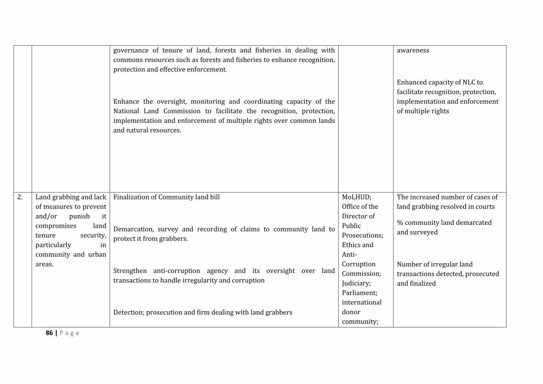
86 | P a g e
governance of tenure of land, forests and fisheries in dealing with
commons resources such as forests and fisheries to enhance recognition,
protection and effective enforcement.
Enhance the oversight, monitoring and coordinating capacity of the
National Land Commission to facilitate the recognition, protection,
implementation and enforcement of multiple rights over common lands
and natural resources.
awareness
Enhanced capacity of NLC to
facilitate recognition, protection,
implementation and enforcement
of multiple rights
2. Land grabbing and lack
of measures to prevent
and/or punish it
compromises land
tenure security,
particularly in
community and urban
areas.
Finalization of Community land bill
Demarcation, survey and recording of claims to community land to
protect it from grabbers.
Strengthen anti-corruption agency and its oversight over land
transactions to handle irregularity and corruption
Detection; prosecution and firm dealing with land grabbers
MoLHUD;
Office of the
Director of
Public
Prosecutions;
Ethics and
Anti-
Corruption
Commission;
Judiciary;
Parliament;
international
donor
community;
The increased number of cases of
land grabbing resolved in courts
% community land demarcated
and surveyed
Number of irregular land
transactions detected, prosecuted
and finalized
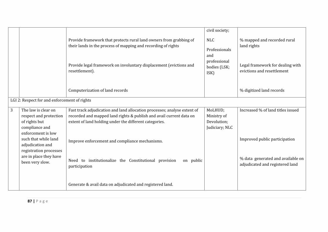
87 | P a g e
Provide framework that protects rural land owners from grabbing of
their lands in the process of mapping and recording of rights
Provide legal framework on involuntary displacement (evictions and
resettlement).
Computerization of land records
civil society;
NLC
Professionals
and
professional
bodies (LSK;
ISK)
% mapped and recorded rural
land rights
Legal framework for dealing with
evictions and resettlement
% digitized land records
LGI 2: Respect for and enforcement of rights
3 The law is clear on
respect and protection
of rights but
compliance and
enforcement is low
such that while land
adjudication and
registration processes
are in place they have
been very slow.
Fast track adjudication and land allocation processes; analyse extent of
recorded and mapped land rights & publish and avail current data on
extent of land holding under the different categories.
Improve enforcement and compliance mechanisms.
Need to institutionalize the Constitutional provision on public
participation
Generate & avail data on adjudicated and registered land.
MoLHUD;
Ministry of
Devolution;
Judiciary; NLC
Increased % of land titles issued
Improved public participation
% data generated and available on
adjudicated and registered land
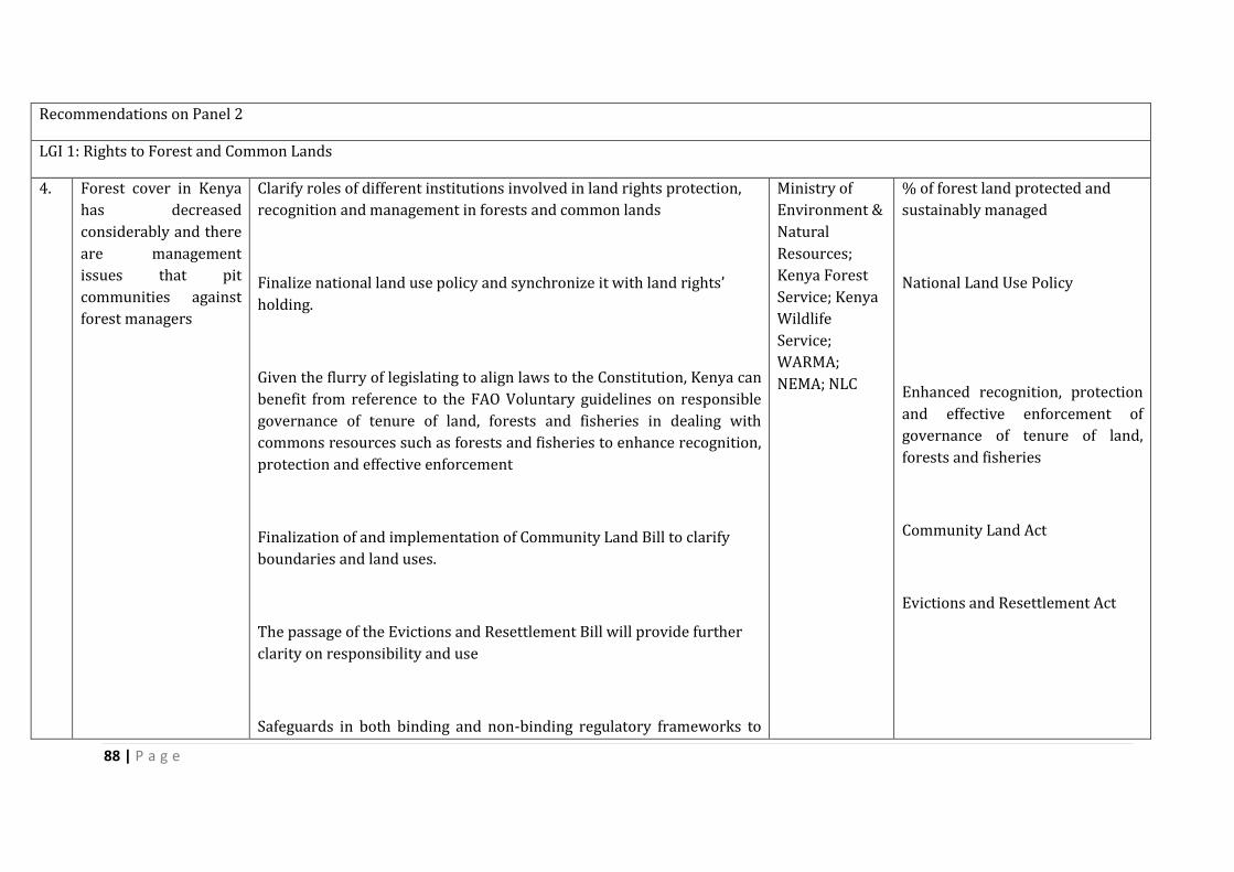
88 | P a g e
Recommendations on Panel 2
LGI 1: Rights to Forest and Common Lands
4. Forest cover in Kenya
has decreased
considerably and there
are management
issues that pit
communities against
forest managers
Clarify roles of different institutions involved in land rights protection,
recognition and management in forests and common lands
Finalize national land use policy and synchronize it with land rights’
holding.
Given the flurry of legislating to align laws to the Constitution, Kenya can
benefit from reference to the FAO Voluntary guidelines on responsible
governance of tenure of land, forests and fisheries in dealing with
commons resources such as forests and fisheries to enhance recognition,
protection and effective enforcement
Finalization of and implementation of Community Land Bill to clarify
boundaries and land uses.
The passage of the Evictions and Resettlement Bill will provide further
clarity on responsibility and use
Safeguards in both binding and non-binding regulatory frameworks to
Ministry of
Environment &
Natural
Resources;
Kenya Forest
Service; Kenya
Wildlife
Service;
WARMA;
NEMA; NLC
% of forest land protected and
sustainably managed
National Land Use Policy
Enhanced recognition, protection
and effective enforcement of
governance of tenure of land,
forests and fisheries
Community Land Act
Evictions and Resettlement Act
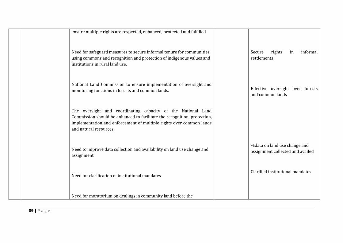
89 | P a g e
ensure multiple rights are respected, enhanced, protected and fulfilled
Need for safeguard measures to secure informal tenure for communities
using commons and recognition and protection of indigenous values and
institutions in rural land use.
National Land Commission to ensure implementation of oversight and
monitoring functions in forests and common lands.
The oversight and coordinating capacity of the National Land
Commission should be enhanced to facilitate the recognition, protection,
implementation and enforcement of multiple rights over common lands
and natural resources.
Need to improve data collection and availability on land use change and
assignment
Need for clarification of institutional mandates
Need for moratorium on dealings in community land before the
Secure rights in informal
settlements
Effective oversight over forests
and common lands
%data on land use change and
assignment collected and availed
Clarified institutional mandates
90 | P a g e
envisaged community land law is put in place to guide any transactions Community Land Act
LGI 2: Effectiveness and equity of rural land use regulations
5. The rural land use
plans in Kenya are
outdated do not cover
all land uses
Need to enforce regulations on restrictions on rural land use which serve
public policy.
Need to institutionalize the Constitutional provision on public
participation and involve communities in decision making on
management of forests.
Need for data on land set aside in forests for specific purposes and its
eventual use.
Finalize national land use policy and synchronize it with land rights’
holding and clarify boundaries and land uses
Need for safeguard measures to secure informal tenure for communities
using commons and recognition and protection of indigenous values and
institutions in rural land use
NLC to facilitate the recognition, protection, implementation and
MoLHUD; KFS;
KWS; County
governments;
Ministry of
Agriculture,
Livestock &
Fisheries;
NEMA; NLC
% of rural land covered by rural
land use plans
Mechanisms on public
participation and community
involvement in decision-making in
the management of forests
Data available on land set aside
and its eventual use
National Land Use Policy
Secure tenure for communities
using commons
Indigenous values and institutions
in rural land use recognized and
protected
Recognition, protection,
91 | P a g e
enforcement of multiple rights over common lands and natural resources
Need to improve data collection and availability on land use change and
assignment
Need to enforce regulations on restrictions on rural land use which serve
public policy
implementation and enforcement
of multiple rights
%data on land use change and
assignment collected and availed
6. The lack of
enforcement of laws
and regulations and
duplication of
mandates for
management of
common lands
Finalization, implementation and enforcement of Community Land Bill
and National Land Use Policy
Implement integrated county development plans
Enhance capacity of land governance institutions to implement laws and
regulations
Strengthen capacity of institutions enforcing laws and regulations
Institute mechanisms for oversight and monitoring of land use and
charge a specific entity to execute it
MOLHUD; NLC;
County
governments;
NEMA;
Parliament;
international
donor
community;
civil society
% of rural land brought under the
National Land Use Policy
92 | P a g e
Improve data collection and availability on land use change and
assignment
Clarify institutional mandates to avoid overlaps and lapses
Recommendations on Panel 3
LGI 1: Restrictions on rights
7. Restrictions on land
use prescribed in the
law are often not
enforced
Implement and strictly enforce planning laws and regulations
Implement city and county development plans
Institutionalize the Constitutional provision on public participation in
the development of integrated plans and master plans
County
Governments;
NEMA
% of land used in line with
updated master plans and
integrated plans in Kenya’s cities
%cities and counties
implementing development plans
Public participation in the
development of integrated plans
and master plans
8. Kenyan cities’
operating on outdated
master plans for cities
are outdated have
New Master Plans have to be developed cities in Kenya as required by
the Urban Areas and Cities Act, 2011 and the proposed national Land
Use Plan
Long awaited National Urban Policy has to be enacted.
MoLHUD,
Cities;
international
donor
community
% of land in cities used in line with
new Master Plans
National Land Use Plan
LGI 2: Transparency of land use restrictions

93 | P a g e
Urban land use
restrictions exist but
have not been made
with the participation
of stakeholders and
are not widely known
Plan for and effect public participation in the preparation,
implementation and review of urban development plans and publish
urban land use restrictions widely
Streamline process of land use change and ensure that land use
transitions to destined use
Cities; NEMA;
Civil Society
% of urban dwellers aware of
existing land use restrictions
%Land use transitions to destined
use
94 | P a g e
LGI 3: Efficiency in the Urban Land Use Planning
9. Kenya has no policy for
low-cost housing and
services for the poor
Develop a Policy on low cost housing with the participation of the poor MOLHUD
Settlement
Division; Cities;
Municipalities
and Urban
areas
Increased number of low-cost
housing available
10. Nairobi and other
cities in Kenya have
developed without a
holistic land use plan
Complete and implement national land use and county integrated
development plans
Slum upgrading initiatives need to be coordinated, better planned and
regularized
Carry out Environmental Impact assessments and Strategic
MOLHUD
Settlement
Division; Cities;
Municipalities
and Urban
areas; Civil
society
% of land in cities used in line with
integrated development plans
% slum upgrading initiatives
coordinated , planned and
regularized

95 | P a g e
Environmental Assessments are carried out and follow through in urban
development
Finalize and implement the building code to guide urban development
Finalize the National Land Use Policy and provide zoning regulations to
guide urban development
%Urban development carried out
in line with EIA & SEA
Building Code
National Land Use Policy
11. Inadequate
infrastructure in the
cities to support
growing populations
Develop infrastructure in line with integrated plans Cities,
municipalities
and urban
areas
% of land used in line with
integrated plans taking
infrastructure needs into account
Unclear and
unaffordable
requirements for
formalizing housing in
informal occupations
Clarify processes for formalizing informal housing and make them
affordable
Provision of services for informal settlement dwellers
Cities,
municipalities
and urban
areas
% of housing formalized in
informal settlements
%informal settlement dwellers
with access to services
Recommendations Panel 4
LGI 1: Identification of public land and clear management
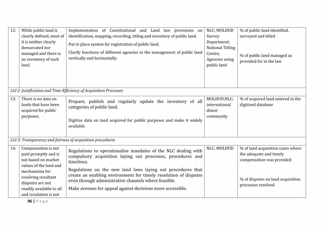
96 | P a g e
12. While public land is
clearly defined, most of
it is neither clearly
demarcated nor
managed and there is
no inventory of such
land.
Implementation of Constitutional and Land law provisions on
identification, mapping, recording, titling and inventory of public land.
Put in place system for registration of public land.
Clarify functions of different agencies in the management of public land
vertically and horizontally.
NLC; MOLHUD
Survey
Department;
National Titling
Centre;
Agencies using
public land
% of public land identified,
surveyed and titled
% of public land managed as
provided for in the law
LGI 2: Justification and Time-Efficiency of Acquisition Processes
13. There is no data on
lands that have been
acquired for public
purposes.
Prepare, publish and regularly update the inventory of all categories of public land.
Digitize data on land acquired for public purposes and make it widely
available
MOLHUD;NLC;
international
donor
community
% of acquired land entered in the
digitized database
LGI 3: Transparency and fairness of acquisition procedures
14. Compensation is not
paid promptly and is
not based on market
values of the land and
mechanisms for
resolving resultant
disputes are not
readily available to all
and resolution is not
Regulations to operationalise mandates of the NLC dealing with compulsory acquisition laying out processes, procedures and timelines.
Regulations on the new land laws laying out procedures that create an enabling environment for timely resolution of disputes even through administrative channels where feasible.
Make avenues for appeal against decisions more accessible.
NLC; MOLHUD % of land acquisition cases where
the adequate and timely
compensation was provided
% of disputes on land acquisition
processes resolved
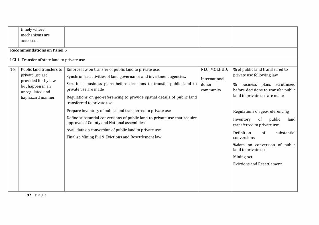
97 | P a g e
timely where
mechanisms are
accessed.
Recommendations on Panel 5
LGI 1: Transfer of state land to private use
16. Public land transfers to
private use are
provided for by law
but happen in an
unregulated and
haphazard manner
Enforce law on transfer of public land to private use.
Synchronize activities of land governance and investment agencies.
Scrutinise business plans before decisions to transfer public land to
private use are made
Regulations on geo-referencing to provide spatial details of public land
transferred to private use
Prepare inventory of public land transferred to private use
Define substantial conversions of public land to private use that require approval of County and National assemblies
Avail data on conversion of public land to private use
Finalize Mining Bill & Evictions and Resettlement law
NLC; MOLHUD;
International
donor
community
% of public land transferred to
private use following law
% business plans scrutinized
before decisions to transfer public
land to private use are made
Regulations on geo-referencing
Inventory of public land
transferred to private use
Definition of substantial conversions
%data on conversion of public land to private use
Mining Act
Evictions and Resettlement
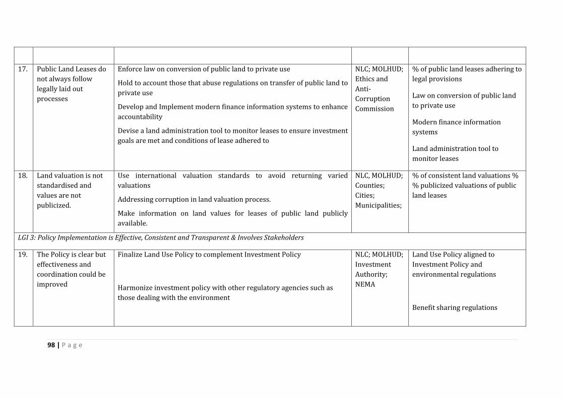
98 | P a g e
17. Public Land Leases do
not always follow
legally laid out
processes
Enforce law on conversion of public land to private use
Hold to account those that abuse regulations on transfer of public land to
private use
Develop and Implement modern finance information systems to enhance
accountability
Devise a land administration tool to monitor leases to ensure investment
goals are met and conditions of lease adhered to
NLC; MOLHUD;
Ethics and
Anti-
Corruption
Commission
% of public land leases adhering to
legal provisions
Law on conversion of public land
to private use
Modern finance information
systems
Land administration tool to
monitor leases
18. Land valuation is not
standardised and
values are not
publicized.
Use international valuation standards to avoid returning varied
valuations
Addressing corruption in land valuation process.
Make information on land values for leases of public land publicly
available.
NLC, MOLHUD;
Counties;
Cities;
Municipalities;
% of consistent land valuations %
% publicized valuations of public
land leases
LGI 3: Policy Implementation is Effective, Consistent and Transparent & Involves Stakeholders
19. The Policy is clear but
effectiveness and
coordination could be
improved
Finalize Land Use Policy to complement Investment Policy
Harmonize investment policy with other regulatory agencies such as
those dealing with the environment
NLC; MOLHUD;
Investment
Authority;
NEMA
Land Use Policy aligned to
Investment Policy and
environmental regulations
Benefit sharing regulations
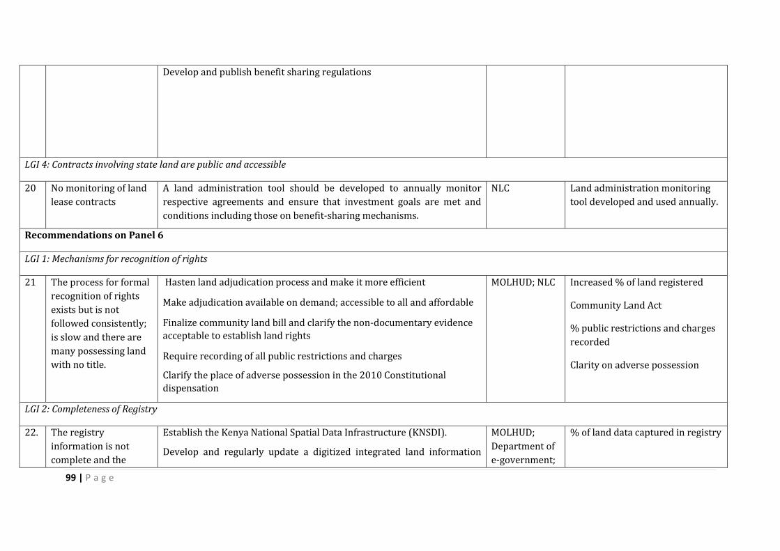
99 | P a g e
Develop and publish benefit sharing regulations
LGI 4: Contracts involving state land are public and accessible
20 No monitoring of land
lease contracts
A land administration tool should be developed to annually monitor
respective agreements and ensure that investment goals are met and
conditions including those on benefit-sharing mechanisms.
NLC Land administration monitoring
tool developed and used annually.
Recommendations on Panel 6
LGI 1: Mechanisms for recognition of rights
21 The process for formal
recognition of rights
exists but is not
followed consistently;
is slow and there are
many possessing land
with no title.
Hasten land adjudication process and make it more efficient
Make adjudication available on demand; accessible to all and affordable
Finalize community land bill and clarify the non-documentary evidence
acceptable to establish land rights
Require recording of all public restrictions and charges
Clarify the place of adverse possession in the 2010 Constitutional
dispensation
MOLHUD; NLC Increased % of land registered
Community Land Act
% public restrictions and charges
recorded
Clarity on adverse possession
LGI 2: Completeness of Registry
22. The registry
information is not
complete and the
Establish the Kenya National Spatial Data Infrastructure (KNSDI).
Develop and regularly update a digitized integrated land information
MOLHUD;
Department of
e-government;
% of land data captured in registry
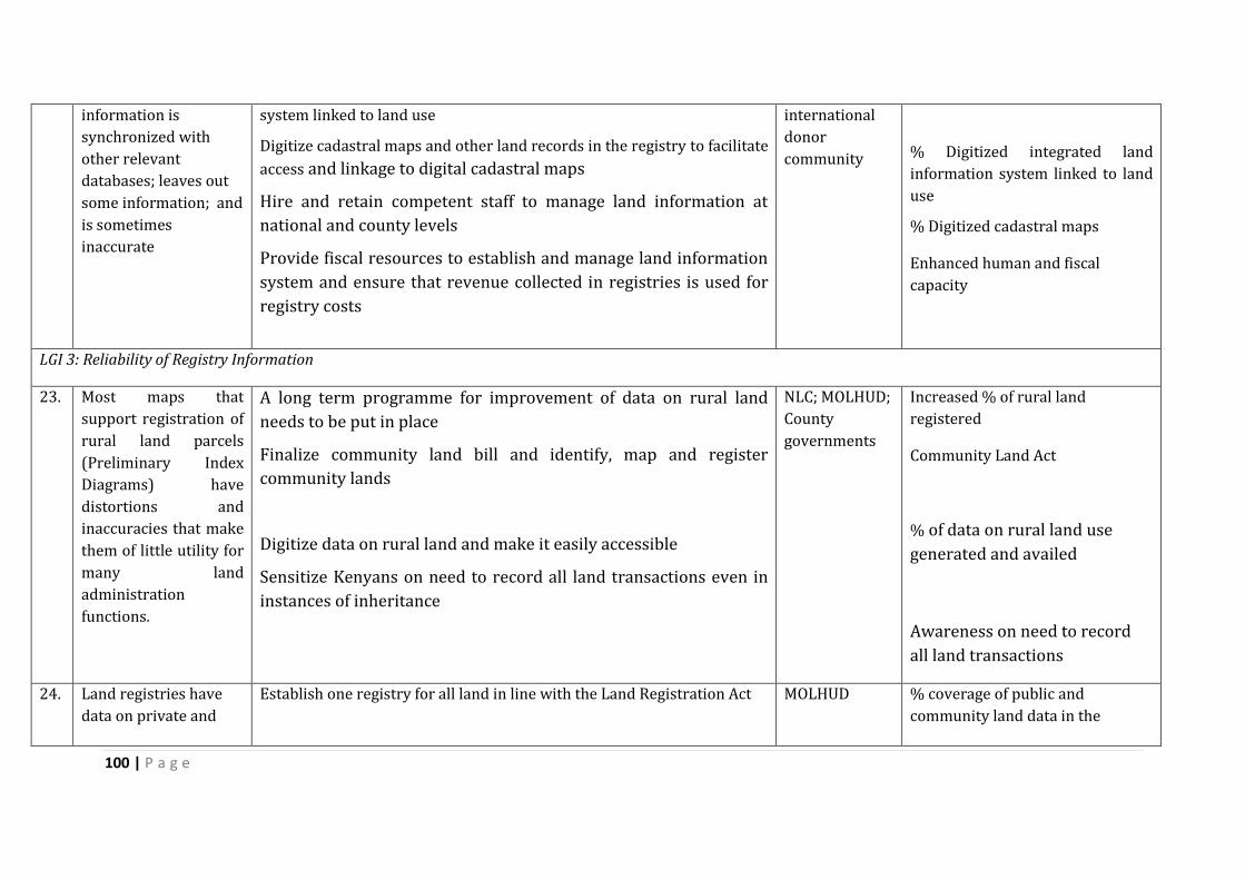
100 | P a g e
information is
synchronized with
other relevant
databases; leaves out
some information; and
is sometimes
inaccurate
system linked to land use
Digitize cadastral maps and other land records in the registry to facilitate
access and linkage to digital cadastral maps
Hire and retain competent staff to manage land information at
national and county levels
Provide fiscal resources to establish and manage land information
system and ensure that revenue collected in registries is used for
registry costs
international
donor
community
% Digitized integrated land
information system linked to land
use
% Digitized cadastral maps
Enhanced human and fiscal
capacity
LGI 3: Reliability of Registry Information
23. Most maps that
support registration of
rural land parcels
(Preliminary Index
Diagrams) have
distortions and
inaccuracies that make
them of little utility for
many land
administration
functions.
A long term programme for improvement of data on rural land
needs to be put in place
Finalize community land bill and identify, map and register
community lands
Digitize data on rural land and make it easily accessible
Sensitize Kenyans on need to record all land transactions even in
instances of inheritance
NLC; MOLHUD;
County
governments
Increased % of rural land
registered
Community Land Act
% of data on rural land use
generated and availed
Awareness on need to record
all land transactions
24. Land registries have
data on private and
Establish one registry for all land in line with the Land Registration Act
MOLHUD % coverage of public and
community land data in the

101 | P a g e
urban land but not on
public and community
land
register
25. Informal payments are
made to procure or
expedite services
institutions.
Introduce use of electronic payment systems to minimize opportunities
for informal payments
Publicize required payments and avail data on collections made by
registries and uses thereof
Institutionalize system to monitor service standards and rewards for
high performance
MOLHUD Increased % of land registered
% use of electronic payment
systems
Mechanisms for monitoring
service standards
Recommendations on Panel 7
LGI 1: Transparency of valuations
26. There is a system of
land valuation in
Kenya but its
administration needs
improvement
Improve land tax administration – coverage; assessment; collection and
enforcement
Ensure complete coverage of all rateable properties and taxable land
transactions
MOLHUD ;
KRA ; Cities ;
Municipalities ;
urban areas ;
county
governments
% increase in land transactions
taxed
% coverage of rateable and taxable
land transactions
27. The process of
assessment of land
values is unclear to
those affected
A clear mechanism should be developed for assessing land tax and
communicated to all
Digitize the fiscal cadastre and develop capacity to manage it
MOLHUD ;
KRA ; Cities ;
Municipalities ;
urban areas ;
county
governments
% of land valuations happening in
timely and transparent manner
Digitized fiscal cadastre
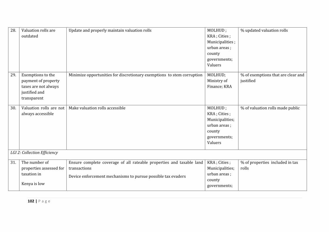
102 | P a g e
28. Valuation rolls are
outdated
Update and properly maintain valuation rolls MOLHUD ;
KRA ; Cities ;
Municipalities ;
urban areas ;
county
governments;
Valuers
% updated valuation rolls
29. Exemptions to the
payment of property
taxes are not always
justified and
transparent
Minimize opportunities for discretionary exemptions to stem corruption MOLHUD;
Ministry of
Finance; KRA
% of exemptions that are clear and
justified
30. Valuation rolls are not
always accessible
Make valuation rolls accessible MOLHUD ;
KRA ; Cities ;
Municipalities;
urban areas ;
county
governments;
Valuers
% of valuation rolls made public
LGI 2: Collection Efficiency
31. The number of
properties assessed for
taxation in
Kenya is low
Ensure complete coverage of all rateable properties and taxable land
transactions
Device enforcement mechanisms to pursue possible tax evaders
KRA ; Cities ;
Municipalities;
urban areas ;
county
governments;
% of properties included in tax
rolls
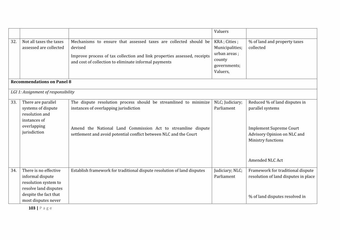
103 | P a g e
Valuers
32. Not all taxes the taxes
assessed are collected
Mechanisms to ensure that assessed taxes are collected should be
devised
Improve process of tax collection and link properties assessed, receipts
and cost of collection to eliminate informal payments
KRA ; Cities ;
Municipalities;
urban areas ;
county
governments;
Valuers,
% of land and property taxes
collected
Recommendations on Panel 8
LGI 1: Assignment of responsibility
33. There are parallel
systems of dispute
resolution and
instances of
overlapping
jurisdiction
The dispute resolution process should be streamlined to minimize
instances of overlapping jurisdiction
Amend the National Land Commission Act to streamline dispute
settlement and avoid potential conflict between NLC and the Court
NLC; Judiciary;
Parliament
Reduced % of land disputes in
parallel systems
Implement Supreme Court
Advisory Opinion on NLC and
Ministry functions
Amended NLC Act
34. There is no effective
informal dispute
resolution system to
resolve land disputes
despite the fact that
most disputes never
Establish framework for traditional dispute resolution of land disputes Judiciary; NLC;
Parliament
Framework for traditional dispute
resolution of land disputes in place
% of land disputes resolved in
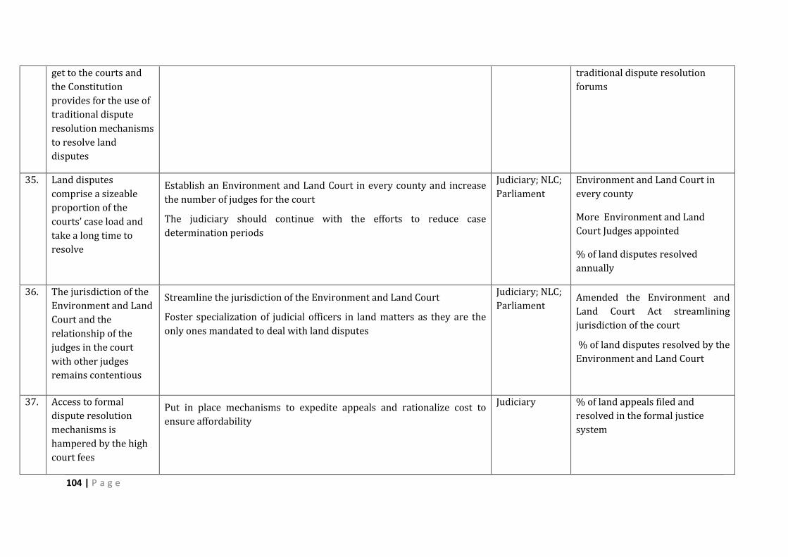
104 | P a g e
get to the courts and
the Constitution
provides for the use of
traditional dispute
resolution mechanisms
to resolve land
disputes
traditional dispute resolution
forums
35. Land disputes
comprise a sizeable
proportion of the
courts’ case load and
take a long time to
resolve
Establish an Environment and Land Court in every county and increase
the number of judges for the court
The judiciary should continue with the efforts to reduce case
determination periods
Judiciary; NLC;
Parliament
Environment and Land Court in
every county
More Environment and Land
Court Judges appointed
% of land disputes resolved
annually
36. The jurisdiction of the
Environment and Land
Court and the
relationship of the
judges in the court
with other judges
remains contentious
Streamline the jurisdiction of the Environment and Land Court
Foster specialization of judicial officers in land matters as they are the
only ones mandated to deal with land disputes
Judiciary; NLC;
Parliament Amended the Environment and
Land Court Act streamlining
jurisdiction of the court
% of land disputes resolved by the
Environment and Land Court
37. Access to formal
dispute resolution
mechanisms is
hampered by the high
court fees
Put in place mechanisms to expedite appeals and rationalize cost to
ensure affordability
Judiciary % of land appeals filed and
resolved in the formal justice
system

105 | P a g e
Recommendations on Panel 9
LGI 1: Clarity of Mandates and Practice
38. There are overlapping
institutional mandates
raising the need for
greater clarity of
institutional mandates
Need to amend land laws to have clarity of institutional mandates
Clarify the roles of the NLC and the Ministry in the administration of land
through legal amendment and fostering a collaborative working
relationship.
Clarify vertical and horizontal mandates of land institutions such as
between MOLHUD and NLC and counties; NLC and sectoral public
institutions that manage land such as KFS and KWS
MOLHUD; NLC;
Parliament
Roles of different institutions
clearly defined
Implement Supreme Court
Advisory Opinion on NLC and
Ministry functions
39. The work of
institutions managing
natural resources on
land is not
synchronized with the
work on land
institutions
Clarify links between natural resource management and land institutions
especially with regard to renewable resources and resources in the sub-
surface resources.
Foster inter-institutional linkages with and collaboration amongst land
and related natural resources’ institutions
Strengthening of institutional coordination to monitor compliance with
ecological imperatives in the use of land
MOLHUD; NLC;
Ministry of
Environment
and Natural
Resources;
Parliament
% of land based natural resources
sustainably managed
Mechanisms for inter-institutional
linkages and collaboration
Mechanisms for monitoring
compliance with ecological
imperatives in the use of land such
as EIA and SEA
40. Ineffective conflict
resolution mechanisms
in the area of land
rights and rights to
natural resources
Refine conflict resolution mechanisms including the Environment and
Land Court and traditional dispute resolution mechanisms to resolve
tenure rights conflicts
MOLHUD; NLC;
Ministry of
Environment
and Natural
Resources;
Strengthened ad aligned tenure
rights’ conflict resolution
mechanisms
% of land and resource tenure
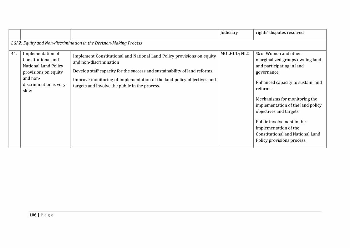
106 | P a g e
Judiciary rights’ disputes resolved
LGI 2: Equity and Non-discrimination in the Decision-Making Process
41. Implementation of
Constitutional and
National Land Policy
provisions on equity
and non-
discrimination is very
slow
Implement Constitutional and National Land Policy provisions on equity
and non-discrimination
Develop staff capacity for the success and sustainability of land reforms.
Improve monitoring of implementation of the land policy objectives and
targets and involve the public in the process.
MOLHUD; NLC % of Women and other
marginalized groups owning land
and participating in land
governance
Enhanced capacity to sustain land
reforms
Mechanisms for monitoring the
implementation of the land policy
objectives and targets
Public involvement in the
implementation of the
Constitutional and National Land
Policy provisions process.

107 | P a g e
VIII. CONCLUSION AND NEXT STEPS The land governance assessment framework happened at an opportune time in Kenya’s
history. After years of review of different frameworks, the first ever national land policy
was concluded in 2009 followed shortly by the promulgation of the Constitution in 2010.
The background research into these two documents provides an incisive review of land
governance in Kenya. These two documents seek to address the shortcomings,
modernize and harmonies the governance structure. It is now five years since the
Constitution was promulgated and the legislative framework dealing with land has been
radically changed to align to the tenets of the Constitution. While the legislative agenda
is far from complete, there is notable traction in the land governance realm with new
institutions, lesser statutes and greater involvement of the citizenry debates. It is
notable that all five registration statutes have been reduced to one and that the
substantive laws on land have been reduced to two. Even though the Community Land
Bill has not been enacted, it is at an advanced stage of development.
There are innovations that are discernible in the Kenya land governance terrain. One is
the establishment of the NLC to manage public land. Despite the hiccups in the
delineation of its mandate Vis a Vis other institutions, NLC represents a symbol of the
triumph of Kenyans in their demand for transparent and accountable governance of
public land. The tussle on mandate is not surprising because decisions had to be made
on who remained responsible for what in a situation where the Ministry had done
everything and was going to lose some functions. There is need to build on the
cooperation and collaboration framework suggested by the Supreme Court to ensure
that Kenyans’ dream of making dealings with public land transparent is not further
deferred.
Another innovation is the establishment of a Land and Environment Court with judges
appointed specifically for that court. The recognition that land disputes take a long time
in the court process and that they require specific attention and some level of expertise
is laudable. The complementing of this court with alternative dispute resolution and
specifically traditional dispute resolution is laudable considering that most disputes on
land occur at very local levels and the majority of them never get to the courts.
From the foregoing, one can conclude that Kenya has an elaborate and dynamic land
governance framework. It is at an interesting and delicate stage of reformulation to align
with the Constitution. While there have been identified points that need to be smoothed
out in the laws, the law is not the problem per se. If the currently operative laws were
implemented and enforced, this would improve land governance substantially. In all the
nine areas reviewed, there is a legal framework whose implementation and enforcement
can be tweaked to improve noted shortcomings.
108 | P a g e
For instance the law on land tenure recognition is clear and institutions are in place to
effect the recognition. There however remain categories of rights’ holders who require
better protection such as women, forest dwellers and residents of informal settlements.
Similarly, there is a basis for the protection of the rights to forest and common lands and
rural land use regulations exist. The problem is in the implementation as well as the
existence of overlapping and contradictory rules that favour public and private rights to
the detriment of communities. The fact that community land legislation is yet to be
enacted and that this category of property had been neglected for long has not helped
the situation.
With regard to urban land use and development, there is a notable commitment to
planning with the requirement for Integrated County Development Plans. These
however are being implemented in a complex situation where the concern is not just
about land but also the resources on the land. Planning within a context where
environmental sustainability demands environmental impact assessments and strategic
environmental assessments has stretched existing personnel tasked with planning
raising the need to enhance capacity.
A major problem that has been noted in the assessment is absence of data and where
data is available, it is dated. Successful land governance requires availability of
information. For instance, valuation rolls for taxation are in exhaustive and not regularly
updated. Considering the percentage of land-based investments, having dated rolls
denies the country of a substantial tax base. It also encourages people to hold land
speculatively as it is a safe space away from the tax man. There is need to provide
current data on land and its uses and align this to the tax system.
It is also not possible to state with certainty how much land in Kenya is public, private or
community. This makes the administration and management of land difficult. There is no
way of ascertaining how much land has changed from one category to the other or to
track and monitor the trends of such changes over time. For instance, it is unclear how
much land has been compulsorily acquired for public purposes and whether this was
from private or community land holders. It is also not clear how much public land has
been allocated for private use. In both instances, the public may want to know whether
they got value for money but that information is not easily accessible.
While there has been some movement towards making information available and
accessible, a lot of work still needs to be done. The problem is both systemic and
structural. Traditionally, government records were all confidential. The
constitutionalisation of the right to information now demands that citizens have access
to information. This is bolstered by the constitutional requirement that citizens
participate in decision-making. Old habits die hard and it is going to take time before the
culture of making information available becomes the norm. Structurally, a lot of land
records are manual and given the sheer volumes, it becomes difficult to access.
109 | P a g e
Moreover, one needs to physically access the documents where they are stored at the
registries.
Apart from the law, there are contextual issues which remain a barrier to the successful
implementation of a robust land governance framework. These include capacity of land
governance institutions and individuals; manual and difficult to access land records;
illegal payments for services; and illegal dealings with land. The absence of a monitoring
system to track the changes over time denies Kenya the opportunity to identify the good
practices to build on and the bad one to discard. A monitoring tool is critical at this point
when many reforms are being carried out. From the assessment, a number of cross-
cutting recommendations have been identified. They include completing the legislative
agenda including crafting operationalising regulations; clarifying and securing tenure
for women, forest dwellers, fisher folk, informal settlements and people in areas with oil
and minerals; ensuring the implementation and enforcement of land related
constitutional provisions and land laws; revising the National Land Policy; finalizing the
National Land Use Policy; rolling out the Kenya National Spatial Data Infrastructure;
digitizing land information to make it data on different aspects of land governance more
easily accessible; building capacity for institutions and staff; Clarification of institutional
mandates; and monitoring to track and measure improvement.
The land governance sector in Kenya is very dynamic. The discussions of the assessment
with actors in the land sector at the validation meeting indicated that quite a lot of
movement has happened since the experts concluded their reports and the Contry
Coordinator compiled the report. As a follow up to the assessment, it would help to
identify the quick wins in land governance and issues that can be sorted out in the short
term and which if resolved can address many of the policy issues. Land information
stands out as one such issue as does the finalization of the national land use policy and
plan. There are many initiatives taking place in the land sector and synergizing them to
improve aspects of the land governance framework identified above would be a step in
the direction of improving land governance in Kenya.
110 | P a g e
IX. SELECT BIBLIOGRAPHY
List of Laws and Policies
1. Republic of Kenya (2014), Draft Community Land Bill (Government Printers, Nairobi)
2. Republic of Kenya (2014), Mining Bill (Government Printers, Nairobi) 3. Republic of Kenya (2014), Natural Resources Benefit Sharing Bill (Government
Printers, Nairobi) 4. Republic of Kenya (2014) Petroleum and Oil Bill (Government Printers, Nairobi) 5. Republic of Kenya (2014) Wildlife Conservation and Management Act
(Government Printers, Nairobi) 6. Republic of Kenya (2012), Environment and Land Court Act Cap. 12A
(Government Printers, Nairobi) 7. Republic of Kenya (2010), Constitution of Kenya (Government Printers, Nairobi) 8. Republic of Kenya (2009), Sessional Paper Number 3 of 2009 on National Land
Policy (Government Printer, Nairobi, 2009) 9. Republic of Kenya (2005), Forest Act (Government Printers, Nairobi) 10. Republic of Kenya (2004) (Statistical Abstract, Nairobi: Bureau of Statistics) 11. Republic of Kenya (2002), Water Act (Government Printers, Nairobi) 12. Republic of Kenya (1999), Environmental Management and Coordination Act
(Government Printers, Nairobi) 13. Republic of Kenya, Land (Group Representatives) Act, Cap. 287 (Repealed) 14. Republic of Kenya, Registered Land Act, Cap. 300 (Repealed) 15. Republic of Kenya, Trust Land Act, Cap 288 (Repealed)
Other Sources
1. Blore I. et al., Municipalities and Finance; A Sourcebook for Capacity Building (Earthscan 2004)
2. Home R. (Ed.), Local Case studies in African land Laws (University of Pretoria: Pretoria University Law Press, 2001)
3. Kameri-Mbote P. & Akech M., Kenya: Justice Sector and the Rule of Law (A review by AfriMAP and the Open Society Initiative for Eastern Africa, Open Society Foundations) (2011)
4. Kameri-Mbote P. et al, Ours by Right: Laws, Politics and Realities of Community Land Rights in Kenya (Strathmore University Legal Press Nairobi, 2013).
5. Kanjama C., Urban Land Value Taxation in Kenya: A case for Reform? (LLM Draft Thesis, 2006)
6. Kenya Land Alliance, Efficacy of Establishing a National Land Commission for Land Administration in Kenya (Kenya Land Alliance, Nakuru, 2005)
7. Kibwana K.,” Efficacy of State Intervention in Curbing the Ills of Individualization of Land Ownership in Kenya,” in Wanjala S.C., Essays on Land Law: The Reform Debate in Kenya (Nairobi, University of Nairobi, 2000) pages 179-191
8. Kiptoo V.K., Land Governance and Accountability Framework – Kenya (Expert Investigator Report, October 2015)
111 | P a g e
9. Land Development and Governance Institute, An Assessment of the Performance of the Environment and Land Court (2014). Available at http://www.ldgi.org/index.php/media-centre/reports-and-publications/38-ldgi-12th-scorecard-report-assessment-of-the-environment-a-land-court/file
10. Mitullah W., Understanding Slums (Case Studies for the Global Report on Human Settlements, 2003).
11. Mwangi W. & Mbugua D., Land Governance Assessment Framework in Kenya (Policy Paper and Ranking, Theme 5: Transparent Process and Economic Benefit: Transfer of Public Land to Private Use follows a Clear, Transparent, and Competitive Process, 2015)
12. Njuguna H. K. and Baya M. M., Land Reforms in Kenya (An Institution of Surveyors of Kenya (ISK) Initiative, Paper presented at The FIG Working Week Conference on New Technology for a New Century, Seoul, Korea, 6-11 May, 2001).
13. Ochieng B.O., “Institutional Arrangements for Environmental Management”[2008] In C.O. Okidi (Ed.), Environmental Governance in Kenya: Implementing the Framework Law, (East African Educational Press, Nairobi, 2008) 183-207
14. Ogolla B.D. with Mugabe J., ‘’Land Tenure Systems’’, In C. Juma and J.B. Ojwang (Eds.), In
Land We Trust: Environment, Private Property and Constitutional Change (Initiative
Publishers, Nairobi, 1996) 15. Okoth-Ogendo H.W.O., "African Land Tenure Reform"[1976] in Heyer, J.J. Maitha and W.
Senga, Agricultural Development in Kenya: An Economic Assessment (Oxford University Press)
16. Republic of Kenya (2002), Report of the Commission of Inquiry into the Land Law System of Kenya (The Njonjo Commission) (Nairobi, Government Printers)
17. Republic of Kenya, Judiciary Transformation Framework (2012-2016) 18. Republic of Kenya, State of the Judiciary and Administration of Justice (Annual Report
2012/2013) 19. Syagga P., "Informal Urban Land Management: Property Rights and Tenure Security in
Kenya" [2012] in Kreibich V. and Olima W.H. (eds.), Urban Land Management in Africa, (Spring Centre, University of Dortmund, Germany)
20. Syagga P., "Informal Urban Land Management: Property Rights and Tenure Security in Kenya", [2012] Vol. 8 Journal of Civil Engineering (March 2003) p13-26
21. Daily Nation, Turkana MP under probe over riots against Tullow oil firm (Wednesday,
October 30, 2013; available at http://www.nation.co.ke/news/MP-under-probe-over-Turkana-
riots/-/1056/2053848/-/3rffmsz/-/index.html) 22. http://www.standardmedia.co.ke/article/2000184276/supreme-court-national-land-
commission-has-no-mandate-to-issue-land-title-deeds 23. http://www.fao.org/docrep/016/i2801e/i2801e.pdf 24. https://thehaguetrials.co.ke/article/kenyan-government-accused-corrupt-handling-
idp-camps
112 | P a g e
X. ANNEXES
A. Annex 1: Participants (Expert Investigators, Panelists)
Expert Investigators
1. Dr. Collins Odote, Panel 1: Land tenure recognition
2. Odenda Lumumba, Panel 2: Rights to forest and common lands & rural land use regulations
3. Steve Ouma, Panel 3: Urban land use, planning, and development
4. Odenda Lumumba, Panel 4: Public land management
5. Dr. Winnie Mwangi, Panel 5: Transparent process and economic benefit: transfer of public land to private use follows a clear, transparent, and competitive process
6. Prof. Galcano Mulaku, Panel 6: Public provision of land information: registry and cadastre
7. Vincent Kiptoo, Panel 7: Land valuation and taxation
8. Dr. Collins Odote, Panel 8: Dispute resolution
9. Dr. Collins Odote & Odenda Lumumba, Panel 9: Review of institutional arrangements and policies –
Two expert investigators (Dr. Collins Odote & Odenda Lumumba) are working on more than
one panel.
Panelists
No Name Institutional Affiliation
1 Agnes Meroka Academic & Women’s Rights
2 Peter Mburu Ministry of Lands (Registration)
3 Odenda Lumumba Kenya Land Alliance
4 Jackie Klopp Researcher on land rights in Kenya, Columbia
University
5 Benson Ochieng Institute for Law and Environmental Governance
113 | P a g e
7 Galcano Mulaku Academic, land administration
8 Yobo Rutin
Centre for Minority Rights and Development
(CEMIRIDE)
9 Joycelene Makena Kenya Wildlife Service
10 Pauline Vata Haki Jamii
11 Elvin Nyukuri University of Nairobi
12 Desmond Tutu University of Nairobi
13 Patricia Kameri-Mbote University of Nairobi
14 Winnie Mwangi Academic, Land valuer
15 Rosemary Wachira Professional Planner
16 Dr. Collins Odote Academic, Land Rights & Natural Resources
17 Mr Jasper Mwenda, Licensed Surveyor in private practice
18 John Maina, Cadastral Survey Officer, Survey of Kenya
19 Eric Nyadimo, Oakar Services Ltd. ( A leading geospatial consultancy firm in East Africa)
20 Vincent Kiptoo, Afriland Valuers
21 Raphael Kieti Former Valuer, Ministry of Lands.
22 Prof. Galcano Mulaku
Academic, land administration

114 | P a g e
Kenya LGAF Scorecard Score
Pan-LGI-Dim Topic A B C D
PANEL 1: Land Rights Recognition
LGI 1: Recognition of a continuum of rights
1 1 1 Individuals' rural land tenure rights are legally recognized and protected in practice.
C
1 1 2 Individuals rural land tenure rights are protected in practice D
1 1 3 Customary tenure rights are legally recognized and protected in practice. B
1 1 4 Indigenous rights to land and forest are legally recognized and protected in practice.
C
1 1 5 Urban land tenure rights are legally recognized and protected in practice. D
LGI 2: Respect for and enforcement of rights
1 2 1 Accessible opportunities for tenure individualisation exist. C
1 2 2 Individual land in rural areas is recorded and mapped. D
1 2 3 Individual land in urban areas is recorded and mapped. C
1 2 4 The number of illegal land sales is low. C
1 2 5 The number of illegal lease transactions is low. C
1 2 6 Women's property rights in lands as accrued by relevant laws are recorded. D
PANEL 2: Rights to Forest and Common Lands & Rural Land Use Regulations
LGI 1: Rights to Forest and Common Lands
2 1 1 Forests are clearly identified in law and responsibility for use is clearly assigned. B
2 1 2 Common lands are clearly identified in law and responsibility for use is clearly assigned.
B
2 1 3 Rural group rights are formally recognized and can be enforced. C
2 1 4 Users' rights to key natural resources on land (incl. fisheries) are legally recognized and protected in practice.
B
2 1 5 Multiple rights over common land and natural resources on these lands can legally coexist.
C
2 1 6 Multiple rights over the same plot of land and its resources (e.g. trees) can legally coexist.
C
2 1 7 Multiple rights over land and mining/other sub-soil resources located on the same plot can legally coexist.
D
2 1 8 Accessible opportunities exist for mapping and recording of group rights. C
2 1 9 Boundary demarcation of communal land. C
LGI 2: Effectiveness and equity of rural land use regulations
2 2 1 Restrictions regarding rural land use are justified and enforced. B
2 2 2 Restrictions on rural land transferability effectively serve public policy objectives. B
2 2 3 Rural land use plans are elaborated/changed via public process and resulting burdens are shared.
B
2 2 4 Rural lands, the use of which is changed, are swiftly transferred to the destined use.
C
2 2 5 Rezoning of rural land use follows a public process that safeguards existing rights. B
2 2 6 For protected rural land use (forest, pastures, wetlands, national parks, etc.) plans correspond to actual use.
B
PANEL 3: Urban Land Use, Planning, and Development
LGI 1: Restrictions on Rights
3 1 1 Restrictions on urban land ownership/transfer effectively serve public policy objectives.
C

115 | P a g e
LGI 2: Transparency of Land Use Restrictions
3 2 1 Process of urban expansion/infrastructure development process is transparent and respects existing rights.
C
3 2 2 Changes in urban land use plans are based on a clear public process and input by all stakeholders.
B
3 2 3 Approved requests for change in urban land use are swiftly followed by development on these parcels of land.
D
LGI 3: Efficiency in the Urban Land Use Planning Process
3 3 1 Policy to ensure delivery of low-cost housing and services exists and is progressively implemented.
D
3 3 2 Land use planning effectively guides urban spatial expansion in the largest city. B
3 3 3 Land use planning effectively guides urban development in the four next largest cities.
B
3 3 4 Planning processes are able to cope with urban growth. C
LGI 4: Speed and Predictability of Enforcement of Restricted Land Uses
3 4 1 Provisions for residential building permits are appropriate, affordable and complied with.
B
3 4 2 A building permit for a residential dwelling can be obtained quickly and at a low cost.
B
LGI 5: Tenure regularization schemes in urban areas
3 5 1 Formalization of urban residential housing is feasible and affordable. C
3 5 2 In cities with informal tenure, a viable strategy exists for tenure security, infrastructure, and housing.
B
3 5 3 A condominium regime allows effective management and recording of urban property.
A
PANEL 4: Public Land Management
LGI 1: Identification of Public Land and Clear Management
4 1 1 Criteria for public land ownership are clearly defined and assigned to the right level of government.
B
4 1 2 There is a complete recording of public land. C
4 1 3 Information on public land is publicly accessible. C
4 1 4 The management responsibility for different types of public land is unambiguously assigned.
B
4 1 5 Responsible public institutions have sufficient resources for their land management responsibilities.
D
4 1 6 All essential information on public land allocations to private interests is publicly accessible.
C
LGI 2: Justification and Time-Efficiency of Acquisition Processes
4 2 1 There is minimal transfer of acquired land to private interests. B
4 2 2 Acquired land is transferred to destined use in a timely manner. A
4 2 3 The threat of land acquisition does not lead to pre-emptive action by private parties.
B
LGI 3: Transparency and Fairness of Acquisition Procedures

116 | P a g e
4 3 1 Compensation is provided for the acquisition of all rights regardless of their recording status.
C
4 3 2 Land use change resulting in selective loss of rights there is compensated for. D
4 3 3 Acquired owners are compensated promptly. B
4 3 4 There are independent and accessible avenues for appeal against acquisition. B
4 3 5 Timely decisions are made regarding complaints about acquisition. C
PANEL 5: Transfer of Large Tracts of Land to Investors
LGI 1: Transfer of Public Land to Private Use Follows a Clear, Competitive Process and Payments are Collected
5 1 1 Public land transactions are conducted in an open transparent manner. D
5 1 2 Payments for public leases are collected. C D
5 1 3 Public land is transacted at market prices unless guided by equity objectives. C
5 1 4 The public captures benefits arising from changes in permitted land use. C
5 1 5 Policy to improve equity in asset access and use by the poor exists, is implemented effectively and monitored.
C
LGI2: Private Investment Strategy
5 2 1 Land to be made available to investors is identified transparently and publicly, in agreement with right holders.
C
5 2 2 Investments are selected based on economic, socio-cultural and environmental impacts in an open process.
C
5 2 3 Public institutions transferring land to investors are clearly identified and regularly audited.
C
5 2 4 Public bodies transferring land to investors share information and coordinate to minimize and resolve overlaps (incl. sub-soil).
C
5 2 5 Compliance with contractual obligations is regularly monitored and remedial action taken if needed.
C
5 2 6 Safeguards effectively reduce the risk of negative effects from large scale land-related investments.
B
5 2 7 The scope for resettlement is clearly circumscribed and procedures exist to deal with it in line with best practice.
C
LGI3: Policy Implementation is Effective, Consistent and Transparent
5 3 1 Investors provide sufficient information to allow rigorous evaluation of proposed investments.
C
5 3 2 Approval of investment plans follows a clear process with reasonable timelines. A
5 3 3 Right holders and investors negotiate freely and directly with full access to relevant information.
B
5 3 4 Contractual provisions regarding benefit sharing are publicly disclosed. B
LGI 4: Contracts Involving Public Land are Public and Accessible
5 4 1 Information on spatial extent and duration of approved concessions is publicly available.
C
5 4 2 Compliance with safeguards on concessions is monitored and enforced effectively and consistently.
C
5 4 3 Avenues to deal with non-compliance exist and obtain timely and fair decisions. C
PANEL 6: Public Provision of Land Information: Registry and Cadastre
LGI 1: Mechanisms for Recognition of Rights
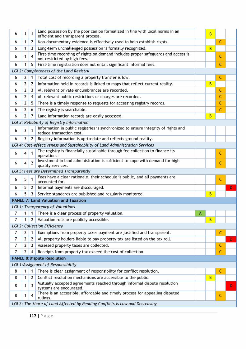
117 | P a g e
6 1 1 Land possession by the poor can be formalized in line with local norms in an efficient and transparent process.
B
6 1 2 Non-documentary evidence is effectively used to help establish rights. C
6 1 3 Long-term unchallenged possession is formally recognized. B
6 1 4 First-time recording of rights on demand includes proper safeguards and access is not restricted by high fees.
C
6 1 5 First-time registration does not entail significant informal fees. C
LGI 2: Completeness of the Land Registry
6 2 1 Total cost of recording a property transfer is low. C
6 2 2 Information held in records is linked to maps that reflect current reality. B
6 2 3 All relevant private encumbrances are recorded. C
6 2 4 All relevant public restrictions or charges are recorded. C
6 2 5 There is a timely response to requests for accessing registry records. C
6 2 6 The registry is searchable. C
6 2 7 Land information records are easily accessed. B
LGI 3: Reliability of Registry Information
6 3 1 Information in public registries is synchronized to ensure integrity of rights and reduce transaction cost.
6 3 2 Registry information is up-to-date and reflects ground reality.
LGI 4: Cost-effectiveness and Sustainability of Land Administration Services
6 4 1 The registry is financially sustainable through fee collection to finance its operations.
C
6 4 2 Investment in land administration is sufficient to cope with demand for high quality services.
C
LGI 5: Fees are Determined Transparently
6 5 1 Fees have a clear rationale, their schedule is public, and all payments are accounted for.
C
6 5 2 Informal payments are discouraged. D
6 5 3 Service standards are published and regularly monitored. B
PANEL 7: Land Valuation and Taxation
LGI 1: Transparency of Valuations
7 1 1 There is a clear process of property valuation. A
7 1 2 Valuation rolls are publicly accessible. B
LGI 2: Collection Efficiency
7 2 1 Exemptions from property taxes payment are justified and transparent. C
7 2 2 All property holders liable to pay property tax are listed on the tax roll. D
7 2 3 Assessed property taxes are collected. C
7 2 4 Receipts from property tax exceed the cost of collection. C
PANEL 8:Dispute Resolution
LGI 1:Assignment of Responsibility
8 1 1 There is clear assignment of responsibility for conflict resolution. C
8 1 2 Conflict resolution mechanisms are accessible to the public. B
8 1 3 Mutually accepted agreements reached through informal dispute resolution systems are encouraged.
D
8 1 4 There is an accessible, affordable and timely process for appealing disputed rulings.
C
LGI 2: The Share of Land Affected by Pending Conflicts is Low and Decreasing
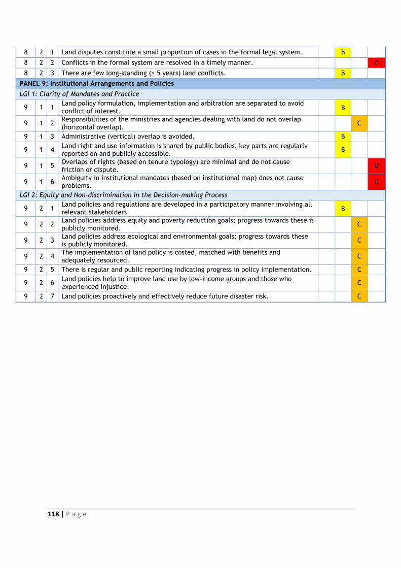
118 | P a g e
8 2 1 Land disputes constitute a small proportion of cases in the formal legal system. B
8 2 2 Conflicts in the formal system are resolved in a timely manner. D
8 2 3 There are few long-standing (> 5 years) land conflicts. B
PANEL 9: Institutional Arrangements and Policies
LGI 1: Clarity of Mandates and Practice
9 1 1 Land policy formulation, implementation and arbitration are separated to avoid conflict of interest.
B
9 1 2 Responsibilities of the ministries and agencies dealing with land do not overlap (horizontal overlap).
C
9 1 3 Administrative (vertical) overlap is avoided. B
9 1 4 Land right and use information is shared by public bodies; key parts are regularly reported on and publicly accessible.
B
9 1 5 Overlaps of rights (based on tenure typology) are minimal and do not cause friction or dispute.
D
9 1 6 Ambiguity in institutional mandates (based on institutional map) does not cause problems.
D
LGI 2: Equity and Non-discrimination in the Decision-making Process
9 2 1 Land policies and regulations are developed in a participatory manner involving all relevant stakeholders.
B
9 2 2 Land policies address equity and poverty reduction goals; progress towards these is publicly monitored.
C
9 2 3 Land policies address ecological and environmental goals; progress towards these is publicly monitored.
C
9 2 4 The implementation of land policy is costed, matched with benefits and adequately resourced.
C
9 2 5 There is regular and public reporting indicating progress in policy implementation. C
9 2 6 Land policies help to improve land use by low-income groups and those who experienced injustice.
C
9 2 7 Land policies proactively and effectively reduce future disaster risk. C
119 | P a g e
C. Annex 3: List of Tables
Table 1: Land Institutions in Kenya Table 2: Ministry of Land, Housing and Urban Development Table 3: Directorates of MOLHUD Table 4: National Land Commission Table 5: Forest Types in Kenya