keith county, nebraska zoning and subdivision regulations · 1 keith county, nebraska zoning and...
TRANSCRIPT
1
KEITH COUNTY, NEBRASKA ZONING AND SUBDIVISION REGULATIONS
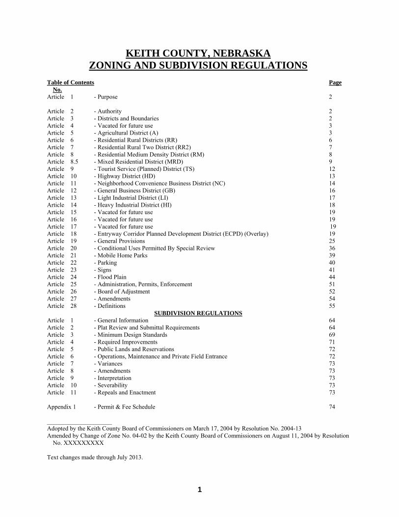
Table of Contents Page
No. Article 1 - Purpose 2
Article 2 - Authority 2 Article 3 - Districts and Boundaries 2 Article 4 - Vacated for future use 3 Article 5 - Agricultural District (A) 3 Article 6 - Residential Rural Districts (RR) 6 Article 7 - Residential Rural Two District (RR2) 7 Article 8 - Residential Medium Density District (RM) 8 Article 8.5 - Mixed Residential District (MRD) 9 Article 9 - Tourist Service (Planned) District (TS) 12 Article 10 - Highway District (HD) 13 Article 11 - Neighborhood Convenience Business District (NC) 14 Article 12 - General Business District (GB) 16 Article 13 - Light Industrial District (LI) 17 Article 14 - Heavy Industrial District (HI) 18 Article 15 - Vacated for future use 19 Article 16 - Vacated for future use 19 Article 17 - Vacated for future use 19 Article 18 - Entryway Corridor Planned Development District (ECPD) (Overlay) 19 Article 19 - General Provisions 25 Article 20 - Conditional Uses Permitted By Special Review 36 Article 21 - Mobile Home Parks 39 Article 22 - Parking 40 Article 23 - Signs 41 Article 24 - Flood Plain 44 Article 25 - Administration, Permits, Enforcement 51 Article 26 - Board of Adjustment 52 Article 27 - Amendments 54 Article 28 - Definitions 55
SUBDIVISION REGULATIONS Article 1 - General Information 64 Article 2 - Plat Review and Submittal Requirements 64 Article 3 - Minimum Design Standards 69 Article 4 - Required Improvements 71 Article 5 - Public Lands and Reservations 72 Article 6 - Operations, Maintenance and Private Field Entrance 72 Article 7 - Variances 73 Article 8 - Amendments 73 Article 9 - Interpretation 73 Article 10 - Severability 73 Article 11 - Repeals and Enactment 73 Appendix 1 - Permit & Fee Schedule 74 _____________________ Adopted by the Keith County Board of Commissioners on March 17, 2004 by Resolution No. 2004-13 Amended by Change of Zone No. 04-02 by the Keith County Board of Commissioners on August 11, 2004 by Resolution
No. XXXXXXXXX Text changes made through July 2013.
2
ZONING REGULATIONS
Article 1 Purpose
Section 1 Minimum Standards These regulations shall permit and regulate development, construction, use and occupancy of land and building in prescribed districts in accordance with minimum standards. These standards have been made with reasonable consideration, among other things, as to the character of each district and its peculiar suitability for particular uses, with a view to conserving the value of buildings and encouraging the most appropriate use of land throughout Keith County. Section 2 In Accordance with Comprehensive Plan These regulations shall be for the purpose of implementing the Comprehensive Plan of the County. Specifically, those policies relating to land use and minimum development quality are strengthened by implementation via these regulations. Section 3 Design and Intent These regulations are intended to lessen congestion in the streets; to secure safety from fire, panic, and other dangers; to promote the health and general welfare; to provide adequate light and air; to prevent the overcrowding of land; to secure safety from flood; to avoid undue concentration; to facilitate the adequate provision for transportation, water, sewerage, schools, parks and other public requirements; to protect the tax base; to secure economy in governmental expenditures; and to preserve, protect, and enhance historic buildings, places, districts, and lakes.
Article 2 Authority Section 1 Authority The Keith County Zoning Resolution and Map is authorized by Chapter 23, Article 1, Section 23-114 et seq., of Nebraska Revised State Statutes as amended, and is hereby declared to be in accordance with all provisions of these statutes. Section 2 Application of Regulations Except as hereinafter provided, no building, structure, or land shall be used and no building or structure or part thereof shall be erected, constructed, reconstructed, altered, moved or structurally altered except in conformance with the regulation herein specified for the zoning district in which it is located; nor shall a yard, lot or open space be reduced in dimensions or area to an amount less than the minimum requirements set forth herein. In addition to other provisions provided herein, the following conditions shall be met prior to issuance of building permits: A) The proposed use shall be placed on a legally existing lot. Said lot either has been in existence prior to the
adoption of these regulations or if created after the adoptions of these regulations, shall meet the provisions of these regulations and those of the Subdivision Regulation if any lot is ten (10) acres or less in size.
B) Each lot shall have frontage on an existing dedicated public street or private roadway. Said frontage shall be equal to the average lot width as described in each zone. The County shall approve any other condition only by processing a subdivision in a manner described by these regulations.
C) These regulations shall not apply to a change in the boundary between adjoining lands that does not create an additional substandard lot.
D) An approach on methods to implement services, such as utility systems, park maintenance, local road maintenance, and related services normally required in subdivision projects. The approach shall be made legally binding on the developer by contract in a manner that is accepted by the County Attorney.
Article 3 Districts and Boundaries
Section 1 Establishment of Zoning Districts In order to carry out the provisions of this resolution, Keith County, Nebraska is hereby divided into the following districts and overlay districts: A -Agricultural RR -Residential Rural RR2 -Residential Rural Two RM -Residential Medium Density MRD -Mixed Residential District TS -Tourist Service (Planned)
3
HD -Highway GB -General Business NC -Neighborhood Convenience Business LI -Light Industrial HI -Heavy Industrial O -Open H -Historic (Overlay) ECPD -Entryway Corridor Planned Development District (Overlay) Section 2 Boundaries The boundaries of these zoning districts are established as shown on a map entitled, the Keith County, Nebraska Zoning Map adopted July 23, 2003 by Resolution No. 2003-43 which map and all future amendments thereto are hereby made a part of this resolution. The zoning map shall be kept up to date and on file in the County Clerk’s office for the use and benefit of the public. Amendments in zoning district boundary lines or designations shall be made on such map within a reasonable time after the effective date of each resolution approving such amendments. The County shall not be required to publish the zoning map after each amendment thereto. Unless otherwise defined on the zoning map, district boundary lines are lot lines; centerline of streets, centerline of alleys, railroad right of way, or such lines extended; section lines; quarter section lines; or other lines drawn to scale on the zoning map. Section 3 Divided Lots When a lot is divided at the time of enactment of this resolution, or by subsequent amendments, by a zoning district boundary line, the less restrictive zoning requirements may be extended not more than twenty five (25) feet into the more restrictive zoning district adjacent to the zoning district boundary line. Section 4 Overlay Districts The overlay districts are established to allow flexibility in the use of special areas. They are processed in the same manner as the other districts and permit the uses spelled out in the overlay district articles.
Article 4 Vacated For Future Use
Article 5 Agricultural District (A) Section 1 Intent It is intended that this district satisfy the basic needs of the Keith County farming and ranching operations. With agriculture being one of the County’s main industries, it is vital that agricultural operations be allowed and protected from encroachments by non-agricultural uses. Therefore, this district does not permit the mixture of intensive residential and other urban uses with agriculture, nor is rezoning to urban use encouraged, unless it complies with the Comprehensive Plan. Some agricultural and non-agricultural uses are, however, found to exist in rural areas, serving rural and urban needs without detriment to agricultural interests under normal conditions with proper design and location. These uses may be permitted by special review and approval by the Planning Commission and the County Commissioners. Section 2 Uses Permitted by Right A. Animals, the raising, breeding and grazing of animals (including but not limited to cattle, poultry, sheep, swine,
rabbits). B. Apiaries. C. Arenas, outdoor. D. Botanical gardens. E. Crops, the raising, storage and sale of items raised on site (including but not limited to dry land and irrigated
farming, truck farming, sod farms, nursery stock and greenhouses). F. Animal Feeding Operations Dairies using a dry manure operation, not within one and one half miles of an
incorporated city or village, not within one mile of a concentration of ten or more homes or residences or a church, a school, recreational camps, parks, playgrounds, golf courses, country clubs, or not within one-half (1/2) mile of a residence not owned by the operator as further defined in Article 20. (Concentration here means ten or more residences within an area one-quarter mile square).
G. Concentrated Animal Feeding Operations, Dairies using a wet manure operation, not within three miles of an incorporated city or village, or a concentration of ten or more homes or residences or a church, a school, recreational camps, parks, playgrounds, golf courses, country clubs, or a residence not owned by the
4
operator as further defined in Article 20. (Concentration here means ten or more residences within an area one-quarter mile square).
H. Fish hatcheries. I. Flood control and irrigating facilities. J. Guest house and quarters. K. Home occupations. L. Oil and gas drilling and transmission. M. Recreation and park facilities (public). N. Religious facilities and quarters. O. Residences as follows:
1) Residences housing families employed on the farm or ranch. Said residences shall be in the ownership of the farmer/rancher employer.
2) Residences on the farm or ranch each housing one family related to the farm or ranch operation. Said residences shall be in the ownership of the farmer/rancher operation.
3) Modular and manufactured homes may be considered as the permitted residence in “1” through “2” above.
4) Non-farm/ranch residence subject to the following: a. Each lot shall have a minimum of 10 acres as noted in Section 4 Minimum Area, Yard Setback
and Height Requirements. 5) A residence located on a farmstead may be subdivided off as a separate lot subject to the following
conditions: a. The residence has existed on the property since 1975, b. The residence complies with the Uniform Building Code, and the Uniform Housing Code,
and Minimum Housing Code. c. The area of the lot is dependent on the soil types. If a standard tank and absorption field
system will not function, then the minimum lot area must be 3 acres. If a standard tank and absorption system will function, then the minimum lot area may be 1.5 acres. The functioning of the septic system will be evaluated on percolation tests supplied by the applicant.
d. A farmstead shall directly access existing roads or streets or exceed the minimum design standards of the Keith County Subdivision Regulations.
e. A farmstead shall contain one residence, and outbuildings shall be on one lot. f. A farmstead shall be platted, a final plat meeting the standards set by the Keith County
Subdivision Regulations is required and a preliminary plat may be required at the discretion of the Keith County Planning Commission.
P. Roadside stands selling products produced on site. Q. Schools, public and private (non-profit). R. Tourist information. S. Sewage and waste water treatment facilities, and water storage and treatment facilities. Section 3 Conditional Uses Permitted by Special Review A. Airports and landing strips. B. Amusement parks. C. Asphalt plants. D. Outdoor Advertising Signs (Billboard Signs). E. Cemeteries, mausoleums and crematories. F. Clubs. G. Colleges and Universities. H. Communication Towers. I. Animal Feeding Operations, Dairies using a dry manure operation, within one and one half miles of an
incorporated city or village, within one mile of a concentration of ten or more homes or residences or a church, a school, recreational camps, parks, playgrounds, golf courses, country clubs, or within one-half (1/2) mile of a residence not owned by the operator as further defined in Article 20. (Concentration here means ten or more residences within an area one-quarter mile square).
J. Concentrated Animal Feeding Operation (CAFO), Dairies using a wet manure operation, within three miles of an incorporated city or village, or a concentration of ten or more homes or residences or a church, a school, recreational camps, parks, playgrounds, golf courses, country clubs, or a residence not owned by the operator as further defined in Article 20. (Concentration here means ten or more residences within an area one-
5
quarter mile square). K. Concrete batch plants. L. Dude ranches. M. Fairgrounds. N. Junk and salvage yards. O. Kennels P. Mobile Homes on a ranch or farm (Refer to definitions of specifics on types and appearance). Q. Oil and gas storage (for use other than on site). R. Large Scale Development (residential). S. Power generating facilities. T. Prisons. U. Race track. V. Recreation and park facilities (private, not to include any type of housing, except a residence for security
purposes). W. Sand, gravel and other mining operations except for agricultural purposes (see Article 20). X. Sanitary landfill operations. Y. Stadiums, indoor. Z. Storage of agricultural products not produced or intended for consumption on site. AA. Telephone exchanges. BB. Utility offices, repair or storage facilities. CC. Veterinary hospital and related facilities. DD. Bed and Breakfasts. Section 4 Minimum Area, Yard Setbacks and Height Requirements Lot area 10 acres Average lot width
Interior lot 600 feet Corner lot 600 feet
Minimum lot width 100 feet Minimum lot depth 500 feet Front yard setback 30 feet Rear yard setback
Principal building 25 feet Accessory buildings 10 feet
Side yard setback Interior lot equal to height of proposed structure Corner lot 30 feet
Maximum building height No limit Section 4A- The developer may make application and the Keith County Planning Commission may grant a waiver of
some or all of the requirements provided in Article 2, Sections 1 and 2 of these regulations for Agricultural, Residential, Commercial and Industrial subdivisions where the following conditions exist:
A) The proposed use shall be placed on a legally existing lot. Said lot either has been in existence prior to the
adoption of these regulations or if created after the adoptions of these regulations, shall meet the provisions of these regulations and those of the Subdivision Regulation if any lot is ten (10) acres or less in size.
B) Each lot shall have frontage on an existing dedicated public street or private roadway. Said frontage shall be equal to the average lot width as described in each zone. The County shall approve any other condition only by processing a subdivision in a manner described by these regulations.
C) These regulations shall not apply to a change in the boundary between adjoining lands that does not create an additional substandard lot.
D) An approach on methods to implement services, such as utility systems, park maintenance, local road maintenance, and related services normally required in subdivision projects. The approach shall be made legally binding on the developer by contract in a manner that is accepted by the County Attorney.
Section 5 General Provisions The use of land in this district shall also conform to the parking, signing, and other provisions of this resolution.
Article 6 Residential - Rural District (RR)
6
Section 1 Intent With the existence of Lake McConaughy has come an interest in rural housing especially around the Lake. Permanent housing in rural areas tends to raise governmental service requirements. This district intends to control density according to services available or services made available through subdivision developments. This district will also provide for acreage type lots throughout the County when appropriate locations are designated. The intent of this district is to assure the environmental and esthetic qualities of Keith County, while retaining the agricultural base. Section 2 Uses Permitted by Right A. Crop production as permitted in the “A” Agricultural district. B. Double wide mobile homes and modular homes. C. Home occupations. D. Grazing of livestock not to exceed one animal unit per 5 acres of land owned or leased. E. Guest housing and quarters. F. Manufactured homes. G. Recreation and park facilities (public and private). H. Religious facilities and quarters. I. Residence (single family). J. Accessory Uses on an individual lot of 2 acres or more without a primary use. Section 3 Conditional Uses Permitted by Special Review A. Airports and landing strips. B. Arenas, outdoor. C. Concessions or retail sales and services needed to serve residential resort areas. D. Flood control and irrigation facilities. E. Group housing use, including but not limited to cabins, motels, lodges. F. Lakefront Lots, waiver of front yard setback when dwelling is fronting on the Lake. G. Oil and gas drilling. H. Large Scale Development. (residential). I. Sewage and waste water treatment facilities, and water storage and treatment facilities. J. Accessory Uses on a lot of less than 2 acres without a primary use. K. Dwelling Unit: Vacation Rental. L. Bed and Breakfasts. Section 4 Minimum Area, Yard Setbacks and Height Requirements Lot area a) 80,000 square feet with private/shared water system and private/shared
wastewater system b) 40,000 square feet with community/public water system or community/public
wastewater system Average lot width
Interior lot a) 200 feet b) 125 feet
Corner lot a) 200 feet b) 125 feet
Minimum lot width 50 feet Minimum lot depth a) 400 feet
b) 200 feet Front yard setback 25 feet Rear yard setback
Principal building 20 feet Accessory buildings 10 feet
Side yard setback Interior lot 10 feet Corner lot 25 feet
Maximum building height 30 feet Section 5 General Provisions The use of land in this district shall also conform to the parking, signing, and other provisions of this resolution.
7
Article 7 Residential Rural Two District (RR2) Section 1 Intent With the existence of Lake McConaughy has come an interest in mobile home housing units around the Lake. Whereas there has been a demand to allow mobile home type units in the same area as site constructed homes, this district intends to provide such types of construction in a compatible way. This district intends to assure the environmental and aesthetic qualities of Keith County and to control density according to services available or services made available through subdivision developments. Section 2 Uses Permitted By Right A. All those uses permitted by right in the Residential Rural (RR) District shall be permitted in this district. B. 1) A single wide mobile home shall have a roof with no less than a 2/12 pitch.
2) A single wide mobile home shall be sided with a permanent, non corrugated type of siding. 3) A single wide mobile home shall be permanently affixed to a permanent footing or foundation in accordance with the building code adopted by the Keith County Board of commissioners. 4) A single wide mobile home shall bear an appropriate seal that indicates it was constructed in accordance with the
standards of the U.S. Department of Housing and Urban Development, or constructed in accordance with the Nebraska Uniform Standards for Modular Housing standards.
Section 3 Conditional Uses Permitted By Special Review A. All those uses permitted by conditional use after special review in the residential rural district shall be permitted
as a conditional use after special review in this district. B. Lakefront Lots, waiver of front yard setback when dwelling is fronting on the Lake. C. Mobile home parks. D. Dwelling Unit: Vacation Rental. E. Bed and Breakfasts. Section 4 Minimum Area, Yard Setbacks and Height Requirements Lot area a) 60,000 square feet with private/shared water system and private/shared
wastewater system b) 40,000 square feet with either a community/public water system or
community/public wastewater system c) 20,000 square feet with both a community/public water system and
community/public wastewater system Average lot width
Interior lot a) 150 feet b) 125 feet
c) 100 feet Corner lot a) 150 feet
b) 125 feet c) 100 feet
Minimum lot width 50 feet Lot depth a) 400 feet b) 200 feet c) 100 feet Front yard setback 25 feet Rear yard setback
Principal building 20 feet Accessory buildings 10 feet
Side yard setback Interior lot 10 feet Corner lot 25 feet
Maximum building height 30 feet Section 5 General Provisions The use of land in this district shall also conform to the parking, signing, and other provisions of this resolution.
Article 8 Residential Medium Density District (RM)
8
Section 1 Intent This district is intended to accommodate existing medium density multiple family residential uses, the expansion of those areas within and adjacent to existing communities, and to provide for a variety of housing types. Section 2 Uses Permitted by Right A. Boarding houses. B. Dwellings, Two-Family. C. Dwellings, Multiple Family. D. Dwellings, Single Family. E. Guest Housing and Quarters. F. Home occupations. G. Preschool nurseries. H. Religious facilities and quarters. I. Rest, retirement or nursing homes. J. Accessory Uses on an individual lot of 2 acres or more without a primary use. K. Bed and Breakfasts. L. Condominiums. M. Townhouses. Section 3 Conditional Uses Permitted by Special Review A. Colleges and universities. B. Clubs. C. Emergency services. D. Health care facilities. E. Medical and dental clinics. F. Mobile home parks. G. Orphanages. H. Accessory Uses on a lot of less than 2 acres without a primary use. I. Dwelling Unit: Vacation Rental. Section 4 Minimum Area, Yard Setbacks and Height Requirements Lot area 40,000 square feet Lot area per unit a) 20,000 square feet without a community/shared water system or a community/shared
wastewater system. b) 10,000 square feet with a community/shared water system or a
community/shared wastewater system. Average lot width
Interior lot a) 100 feet Corner lot b) 100 feet
Minimum lot width 50 feet Minimum lot depth 150 feet Front yard setback 25 feet Rear yard setback
Principal buildings 20 feet Accessory buildings 10 feet
Side yard setback Interior lot 10 feet Corner lot 20 feet
Maximum building height 30 feet Section 5 Open Space A minimum of forty percent (40%) of the site shall be developed and maintained as private open space and recreation use for occupants of the project. Section 6 General Provisions The use of land in this district shall also conform to the parking, signing, and other provisions of this resolution.
Article 8.5 Mixed Residential District (MRD)
9
PURPOSE: In the creation of the new Mixed Residential District, we are, in essence, providing for the creation of a small town by mixing residential, commercial/service business and public facilities together in one development. Section 1: Intent This district is intended to accommodate a variety of residential uses in separate settings or clusters as uses by right and a variety of commercial/service businesses as Conditional uses. Section 2: Uses by Right
A. Boarding houses. B. Dwellings, single family in either large lot or cluster developments. C. Dwellings, duplex. D. Dwellings, Townhouse. E. Dwellings, Condominium. F. Dwellings, Multiple Family provided no single structure houses more than four units. G. Dwelling, Cottage. H. Home occupations. I. Preschool nurseries.
Section 3: Conditional Uses: A. Art Galleries. B. Banking, financial, including drive up facilities not to exceed 1,200 square feet in gross floor area. C. Campgrounds to include RV parks. D. Dwelling: Guest House and Guest Quarters. E. Dwelling: Mobile Home Park. F. Dwelling: Vacation Rentals and Time share. G. Emergency Services to include public and private services. H. Flood Control structures and Irrigation facilities. I. Golf Course and other indoor or outdoor athletic facilities. J. Health Care Facilities not to exceed 1,200 square feet in gross floor area. K. Historic sites. L. Neighborhood retail commercial units that will be compatible to nearby residential uses and serve the basic
shopping and service needs for convenience items, such uses are not to exceed 2,000 square feet of gross floor area.
M. Office services to include but not limited to professionals in law, accounting, physicians, realtors and engineering.
N. Public and private schools. O. Recreation and park facilities. P. Religious facilities. Q. Restaurants, coffee shops, bakeries; not to include fast food franchises, and not to exceed 2,000 square feet in
gross floor area. R. Service stations to be located only at the entrance to the MRD and not to exceed 2,000 square feet in gross floor
area. S. Storage facilities. T. Veterinary clinics not to exceed 1,200 square feet in gross floor area and not to include kennels for multiday
rental. U. Water and waste water treatment facilities
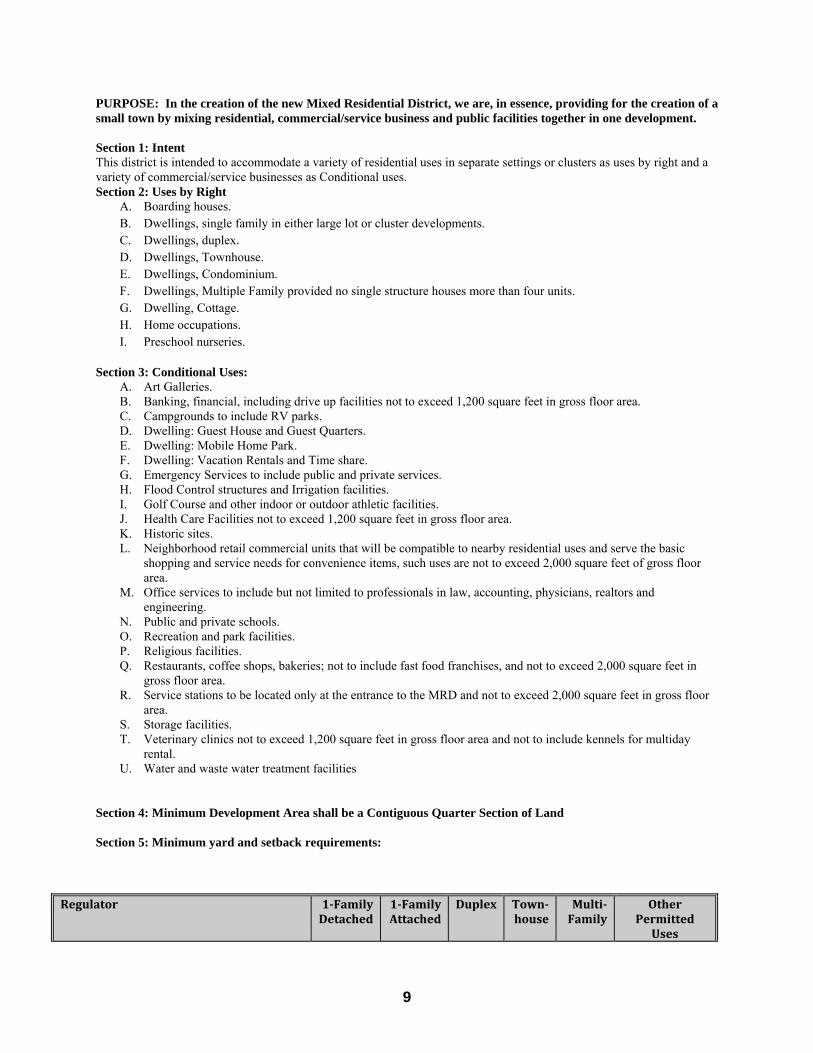
Section 4: Minimum Development Area shall be a Contiguous Quarter Section of Land Section 5: Minimum yard and setback requirements:
Regulator 1‐FamilyDetached
1‐FamilyAttached
Duplex Town‐house
Multi‐Family
OtherPermittedUses
10
SiteAreaperHousingUnit(sqft)InConventionalSubdivisions InClusterSubdivisions
40,00040,000
40,00040,000
40,00040,000
40,00020,000
40,00010,000
MinimumLotAreaInConventionalSubdivisionsIndividualWaterandWastewaterCommunityWaterCommunityWaterandWastewaterInClusterSubdivisionsIndividualWaterandWastewaterCommunityWaterCommunityWaterandWastewater
40,00020,00015,000
40,00020,0005,000
40,00020,00015,000
40,00020,0005,000
40,00020,00015,000
40,00020,00010,000
40,00020,00010,000
40,00020,0004,000perunit
NANA
160,00
NANA
40,000
MinimumLotWidth(feet)InteriorLots InConventionalSubdivisions InClusterSubdivisionsCornerLots
InConventionalSubdivisions InClusterSubdivisions
10050
15075
10050
15075
15075
200100
5035
7540
10075
150100
MinimumYards(feet)(MaybevariedforclustersubdivisionsconsistentwithSection2) FrontYard SideYard(forunattachedsideyards) StreetSideYard RearYard
25102530
25102530
25101530
25101530
25152530
MaximumHeight(feet) 35 35 35 35 45MaximumBuildingCoverage
InConventionalSubdivisionsInClusterSubdivisions
30%50%
30%50%
35%60%
45%60%
50%65%
Section 6: Conditional Use minimum lot area, setbacks, height and related requirements: A. Lot area 1 Acre Average lot width
Interior lot 100 feet Corner lot 100 feet
Minimum lot width 50 feet Minimum lot depth 150 feet Front yard setback 25 feet from any street or private road right-of-way. Rear yard setback
Principal buildings 20 feet Accessory buildings 10 feet
Side yard setback Interior lot 10 feet Corner lot 20 feet
Special Circumstances See ‘E’ below Maximum building height 30 feet
B. A landscaped area of at least ten feet in width shall be provided adjacent to any street or private road abutting the commercial site.
C. If across a street or private roadway from a residential district, a landscaped area not less than twenty-five feet in width shall be provided paralleling the street or private roadway.
D. A landscape screen or solid fence at least six feet in height shall be installed on the commercial property when abutting or adjacent to any residential property.
E. When abutting a residential district, the yard between the zone district boundary and any building shall be two

11
times the height of the proposed building. F. Curb cuts may be permitted through the landscaped area. (The minimum curb cut width is 24 feet and the
maximum curb cut width is 36 feet.) Section 7: The use of land in this district shall also conform to the parking, signing and other provisions of this ordinance. Section 8: Creation of Mixed Residential Districts (MRD’s) shall follow the requirements and standards found in Article 19: General Provisions Section 15: Large Scale Developments. Section 9: Performance Requirements
A. The applicant shall satisfy the Planning Commission that they have the financial ability to carry out the proposed plan and shall prepare for submittal a schedule of construction. The proposed construction shall begin within a period of twelve months following the approval of the final plan by the County Board. A minimum of fifty percent of the total planned construction shown on the final plan shall be completed within a period of five years following such approval or the plan shall expire. The period of time established for the completion of the development may be modified by the Planning Commission upon the showing of good cause by the developer.
B. The developer shall provide and record easements and covenants, shall make such arrangements, and shall furnish such performance bonds, escrow deposit, or other financial guarantees as may be determined by the County Board to be reasonably required to assure performance in accordance with the development plan and to protect the public interest in the event of abandonment of said plan prior to completion.
C. The MRD shall include provisions for the ownership and maintenance of the common open spaces through a homeowners association and such provisions as are reasonably necessary to insure it continuity, care, conservation and maintenance. The MRD shall include provisions to insure that remedial measures will be available to the County Board if the common open space is permitted to deteriorate or is not maintained in a condition consistent with the best interests of the residents of the MRD or of the entire neighboring community.
D. The MRD may allow for Cluster Developments provided they meet the definition found in this Ordinance and the developer creates an open space area which also contains a centralized sanitary sewer system which meets all requirements of the Nebraska Department of Environmental Quality for design and capacity , including all necessary permits.
E. The approval of the preliminary plan may include a schedule or stages of development, however no building permits shall be issued outside of the consecutive stages of development and only when that entire ‘stage’ has received final plat approval.
Section 10: Density Bonuses apply only where there is community water and sewer systems: A. The use of the MRD, in conjunction with Conservation Easements shall permit a developer the use of density
bonuses in subdivisions served by community water and sewer systems
B. A Density Bonus shall be awarded in direct proportion to the amount of land in the proposed subdivision that is placed within a Conservation Easement.
For Example: If a developer places 30% of the proposed subdivision into a Conservation Easement, then the required lot area may be reduced by 30% in order to maintain the same number of lots that would have been allowed by the subdivision lot area and the minimum lot size of the Zoning Ordinance: Normal development with community water and sewer in the RR District. The development is 160 acres: 6,969,600 sq. ft.
Minimum lot area in RR with community water and sewer is 40,000 sq. ft.
Gross number of lots 174.
Density bonus with Conservation Easement in RR with community water and sewer. The development is 160 acres: 6,969,600 sq. ft.

12
RR zoning allows for 174 lots.
30% of land put in conservation easement: 2,090,880 sq. ft.
New minimum lot size of 28,039 sq. ft.
Article 9 Tourist Services (Planned) District (TS)
Section 1 Intent This district is intended to serve a developing area with retail/commercial uses that are frequently found near interchanges and busy highways, or in established resort/tourist areas in the villages and communities around the Lake. This district requires a conditional use permit for the integration of uses with the surrounding area. This district is not intended to serve all business activity, nor should this district be used to create endless commercial strips along major highways. Tourist related and community oriented businesses are the primary uses in this district. Section 2 Uses Permitted By Right A. Flood control and irrigation. B. Historic sites, and tourist information centers. C. Recreation and parks (public). D. Emergency services. E. Bed and Breakfasts. Section 3 Conditional Uses Permitted by Special Review A. Amphitheaters. B. Aquariums. C. Arenas, fairgrounds and stadiums (outdoor). E. Botanical gardens. F. Bus and taxi depot. G. Caretaker or business related living quarters. H. Motels and hotels I. Museums J. Outdoor Advertising Signs (Billboard Signs). K. Large Scale Developments L. Religious facilities and quarters M. Restaurants up to 5,000 square feet. N. Service stations up to 5,000 square feet. O. Sewage and wastewater treatment and water storage and treatment facilities. P. Stores and shops for the sale of goods at retail up to 5,000 square feet per business, but not including motor
vehicles. Q. Theaters R. Zoos. S. Dwelling Unit: Vacation Rental. T. Campground. Section 4 Minimum Area, Yard Setbacks, Height Requirements, and Related Requirements. A. Lot area 1 Acre Average lot width
Interior lot 100 feet Corner lot 100 feet
Minimum lot width 50 feet Lot depth 150 feet Front yard setback 25 feet from any street or private road right-of-way. Rear yard setback
Principal buildings 20 feet Accessory buildings 10 feet
Side yard setback Interior lot 10 feet
13
Corner lot 20 feet Special Circumstances See ‘F’ below Maximum building height 30 feet B. A landscaped area of at least ten feet in width shall be provided adjacent to any street or private road abutting
the commercial site. C. If across a street or private roadway from a residential district, a landscaped area not less than twenty-five feet
in width shall be provided paralleling the street or private roadway. D. A landscape screen or solid fence at least six feet in height shall be installed on the commercial property when
abutting or adjacent to any residential property. E. When abutting a residential district, the yard between the zone district boundary and any building shall be two
times the height of the proposed building. F. Curb cuts may be permitted through the landscaped area. (The minimum curb cut width is 24 feet and the
maximum curb cut width is 36 feet.) Section 5 General Provisions Use of land in this district shall also conform to the parking, loading, signing, and other provisions of this resolution.
Article 10 Highway District (HD)
Section 1 Intent This district is intended to serve those areas within and adjacent to existing communities that are designed primarily to serve one stop shopping or auto related needs. This district should not be used to create an endless business strip along major highways. This district will be located along highways to adequately serve auto related and convenience needs. Section 2 Uses Permitted By Right A. Automotive vehicle, implement, marine craft, mobile home, recreational vehicle sales, services, and storage. B. Aquariums. C. Amphitheaters, auditoriums, fairgrounds, exhibition halls, arenas and stadiums. D. Bus, taxi, and train depots. E. Banks and financial institutions. F. Building materials sales. G. Car wash facilities. H. Clubs. I. Colleges and universities. J. Communication centers and telephone exchanges. K. Construction yards and services. L. Cemeteries, mausoleums and crematories. M. Dry cleaners. N. Emergency services. O. Flood control and irrigation facilities. P. Historic sites and tourist information centers. Q. Health care facilities. R. Hotels and motels. S. Liquor sales, on-site consumption and off-site sales. T. Parking garages. U. Plant nursery and sales. V. Printing and newspapers. W. Recreation and parks, public and private. X. Religious facilities and quarters. Y. Restaurants, including drive-in restaurants. Z. Sewage and wastewater treatment facilities and water storage and treatment facilities. AA. Service stations. BB. Theaters. CC. Veterinary hospitals. Section 3 Conditional Uses Permitted by Special Review (see Article 20) A. Amusement parks. B. Caretaker of business related to living quarters.
14
C. Gas storage and distribution D. Kennels E. Large Scale Development (commercial) F. Outdoor Advertising Signs (Billboard Signs). G. Race tracks H. Retail stores Section 4 Minimum Area, Yard Setbacks, Height Requirements, and Related Requirements. A. Lot area 1 Acre Average lot width
Interior lot 100 feet Corner lot 100 feet
Minimum lot width 50 feet Lot depth 150 feet Front yard setback 25 feet from any street or private road right-of-way. Rear yard setback
Principal buildings 20 feet Accessory buildings 10 feet
Side yard setback Interior lot 10 feet Corner lot 20 feet
Special circumstances See ‘E’ below Maximum building height 30 feet B. A landscaped area of at least ten feet in width shall be provided adjacent to any street or private road abutting
the commercial site. C. If across a street or private roadway from a residential district, a landscaped area not less than twenty-five feet
in width shall be provided paralleling the street or private roadway. D. A landscape screen or solid fence at least six feet in height shall be installed on the commercial property when
abutting or adjacent to any residential property. E. When abutting a residential district, the yard between the zone district boundary and any building shall be two
times the height of the proposed building. F. Curb cuts may be permitted through the landscaped area. (The minimum curb cut width is 24 feet and the
maximum curb cut width is 36 feet.) Section 5 General Provisions Use of land in this district shall also conform to the parking, signing, loading, and other provisions of this resolution.
Article 11 Neighborhood Convenience Business District (NC)
Section 1 Intent This district will serve basic shopping and service needs for convenience items. Ideally, it is within walking or short riding distance of the neighborhood being served. Being placed near residential areas requires that the site and the use shall be compatible with the nearby residential districts. This district is intended to serve existing communities and expanding areas adjacent thereto. Section 2 Uses Permitted by Right A. Appliance repair and sales. B. Art galleries. C. Banking and financial, including drive-in facilities. D. Botanical gardens. E. Bus and taxi depots. F. Colleges and Universities. G. Communication centers, and telephone exchanges. H. Dry cleaning and laundry. I. Emergency services. J. Flood control and irrigating facilities. K. Health care facilities.
15
L. Historic sites. M. Libraries. N. Liquor off-sale. P. Office services. Q. Parking garages. R. Personal services shops. S. Plant nursery. T. Preschools and child care facilities. U. Professional and business offices. V. Recreation and park facilities. W. Religious facilities and quarters. X. Restaurants, excluding drive-ins. Y. Retail stores with all products enclosed with in a building. Z. Theaters, excluding drive-ins. Section 3 Conditional Uses Permitted by Special Review (see Article 20) A. Automotive vehicles sales and services. B. Caretakers of business, related living quarters. C. Car wash facilities. D. Clubs. E. Liquor sales for on-site consumption. F. News syndicate services G. Outdoor Advertising Signs (Billboard Signs). H. Large Scale Development (commercial) I. Restaurants, drive-ins. J. Service stations. K. Sewage and waste water treatment facilities, and water storage and treatment facilities. L. Veterinary hospitals Section 4 Minimum Area, Yard Setbacks, Height Requirements, and Related Requirements. A. Lot area 1 Acre Average lot width
Interior lot 100 feet Corner lot 100 feet
Minimum lot width 50 feet Minimum lot depth 150 feet Front yard setback 25 feet from any street or private road right-of-way. Rear yard setback
Principal buildings 20 feet Accessory buildings 10 feet
Side yard setback Interior lot 10 feet Corner lot 20 feet
Special Circumstances See ‘E’ below Maximum building height 30 feet B.
A landscaped area of at least ten feet in width shall be provided adjacent to any street or private road abutting the commercial site.
C. If across a street or private roadway from a residential district, a landscaped area not less than twenty-five feet in width shall be provided paralleling the street or private roadway.
D. A landscape screen or solid fence at least six feet in height shall be installed on the commercial property when abutting or adjacent to any residential property.
E. When abutting a residential district, the yard between the zone district boundary and any building shall be two times the height of the proposed building.
F. Curb cuts may be permitted through the landscaped area. (The minimum curb cut width is 24 feet and the maximum curb cut width is 36 feet.)
Section 6 General Provisions
16
Use of land in this district shall also conform to the parking, loading, signing and other provisions of this resolution.
Article 12 General Business District (GB) Section 1 Intent The general business district serves existing multipurpose business areas such as established in the existing communities and the expansion of such areas. Section 2 Uses Permitted by Right A. All those uses permitted by right in the neighborhood convenience business district shall be permitted in this
district. B. Amphitheaters and auditoriums C. Appliance and household items repair and servicing D. Aquariums E. Automotive accessory repair and sales F. Clubs G. Electrical shops H. Emergency services. I. Gas stations. J. Hotels and motels. K. Liquor sales (on site and carry out). L. Mortuaries. M. News syndicate services. N. Printing and newspaper offices. O. Religious facilities and quarters. P. Rental agencies. Q. Restaurant, drive-ins. R. Retail sales. S. Tourist information. T. Train depots. U. Veterinary hospitals. Section 3 Conditional Uses Permitted by Special Review (see Article 19) A. All those conditional uses permitted by special review in the Neighborhood Convenience District shall be
permitted by special review in this district unless otherwise listed as a permitted use in district. B. Building materials sales. C. Outdoor Advertising Signs (Billboard Signs). D. Recreation, commercial. Section 4 Minimum Area, Yard Setbacks, Height Requirements, and Related Requirements. A. Lot area 1 Acre Average lot width
Interior lot 100 feet Corner lot 100 feet
Minimum lot width 50 feet Minimum lot depth 150 feet Front yard setback 25 feet from any street or private road right-of-way. Rear yard setback
Principal buildings 20 feet Accessory buildings 10 feet
Side yard setback Interior lot 10 feet Corner lot 20 feet
Special Circumstances See ‘E’ below Maximum building height 30 feet B. A landscaped area of at least ten feet in width shall be provided adjacent to any street or private road abutting
the commercial site.
17
C. If across a street or private roadway from a residential district, a landscaped area not less than twenty-five feet in width shall be provided paralleling the street or private roadway.
D. A landscape screen or solid fence at least six feet in height shall be installed on the commercial property when abutting or adjacent to any residential property.
E. When abutting a residential district, the yard between the zone district boundary and any building shall be three times the height of the proposed building.
F. Curb cuts may be permitted through the landscaped area. (The minimum curb cut width is 24 feet and the maximum curb cut width is 36 feet.)
Section 5 General Provisions Uses of land in this district shall also conform to the parking, loading, signing and other provisions of this resolution.
Article 13 Light Industrial District (LI) Section 1 Intent This district is intended to serve industrial activities within and adjacent to existing communities. The uses are not obnoxious and are fully enclosed or screened from public view, with proper design, landscaping and traffic control. Section 2 Uses Permitted by Right A. Any manufacturing, processing, fabrication or warehousing activity that is completely confined within a closed
building and does not normally emit noise, smoke, or odor outside of the building. B. Gas storage and distribution. C. Oil and gas drilling. D. Printing and newspaper facilities. E. Recreation, public. F. Related commercial activities such as offices, restaurants, or gas stations and other commercial activities that
primarily serve industrial activities. G. Religious facilities and quarters. H. Train depots. I. Utility offices and storage yards. J. Sewage and waste water treatment facilities, and water storage and treatment facilities. Section 3 Conditional Uses Permitted by Special Review (see Article 20) A. Airports and landing strips. B. Implement sales and service. C. Large Scale Development. (industrial). D. Power generating. E. Those industrial uses which normally are associated with noise, odor or smoke, but due to site or method of
design, can be compatible with the intent of the district. Section 4 Minimum Area, Yard Setbacks, Height Requirements, and Related Requirements. A. Lot area 1 Acre Average lot width
Interior lot 100 feet Corner lot 100 feet
Minimum lot width 50 feet Minimum lot depth 150 feet Front yard setback 25 feet from any street or private road right-of-way. Rear yard setback
Principal buildings 20 feet Accessory buildings 10 feet
Side yard setback Interior lot 10 feet Corner lot 20 feet
Special Circumstances See ‘E’ below Maximum building height 40 feet B. A landscaped area of at least ten feet in width shall be provided adjacent to any street or private road abutting
18
the industrial site. C. If across a street or private roadway from a residential district, a landscaped area not less than twenty-five feet
in width shall be provided paralleling the street or private roadway. D. A landscape screen or solid fence at least six feet in height shall be installed on the industrial property when
abutting or adjacent to any residential property. E. When abutting a residential district, the yard between the zone district boundary and any building shall be three
times the height of the proposed building. F. Curb cuts may be permitted through the landscaped area. (The minimum curb cut width is 24 feet and the
maximum curb cut width is 36 feet.) Section 5 General Provisions Use of land in this district shall also conform to the parking, loading, signing and other provisions of this resolution.
Article 14 Heavy Industrial District (HI) Section 1 Intent It is intended that this district serve the heavier industrial uses requiring heavy truck traffic, and creating noise, smoke and odor. This district will frequently serve the needs of agricultural related business. It is also intended to be used within and adjacent to existing communities. Section 2 Uses Permitted by Right A. All those uses that meet the requirements of the light industrial district and are listed as permitted uses. B. Those manufacturing, processing and warehousing activities that generate heavy truck traffic, noise, smoke or
odor which cannot be maintained on the site. These obnoxious characteristics shall be maintained within the boundaries of this heavy industrial district.
Section 3 Conditional Uses Permitted by Special Review (see Article 20) A. Alfalfa dehydrators. B. Auto wrecking yards and other salvage operations. C. Cement, lime or gypsum processing. D. Chemical plants. E. Fertilizer manufacturing. F. Large Scale Development. (industrial). G. Slaughter houses. H. Stockyards. I. Tanneries. Section 4 Minimum Area, Yard Setbacks, Height Requirements, and Related Requirements. A. Lot area 1 Acre Average lot width
Interior lot 100 feet Corner lot 100 feet
Minimum lot width 50 feet Minimum lot depth 150 feet Front yard setback 25 feet from any street or private road right-of-way. Rear yard setback
Principal buildings 20 feet Accessory buildings 10 feet
Side yard setback Interior lot 10 feet Corner lot 20 feet
Special Circumstances See ‘E’ below Maximum building height 40 feet B. A landscaped area of at least ten feet in width shall be provided adjacent to any street or private road abutting
the industrial site. C. If across a street or private roadway from a residential district, a landscaped area not less than twenty-five feet
in width shall be provided paralleling the street or private roadway.
19
D. A landscape screen or solid fence at least six feet in height shall be installed on the industrial property when abutting or adjacent to any residential property.
E. When abutting a residential district, the yard between the zone district boundary and any building shall be three times the height of the proposed building.
F. Curb cuts may be permitted through the landscaped area. (The minimum curb cut width is 24 feet and the maximum curb cut width is 36 feet.)
Section 5 General Provisions Use of land in this district shall also conform to the parking, loading, signing and other provisions of this resolution.
Article 15 Vacated For Future Use
Article 16 Vacated For Future Use
Article 17 Vacated For Future Use
Article 18 Entryway Corridor Planned Development District (ECPD) (Overlay) Section 1 Purpose and Intent
The Entryway Corridor Planned Development Overlay District is intended to assure that development in strategic segments of the Highway 26, Highway 30, Highway 61, and Highway 92 corridors take advantage of growth opportunities while maintaining the rural character of Keith County. The district establishes design standards and performance requirements that protect the visual integrity of the corridor and advance the development objectives of Keith County. These objectives include:
Recognizing the growth and development opportunities created by increasing numbers of visitors and residents attracted to Lake McConaughy.
Providing design standards that assure that development respect the character of the rural character. Maintaining the functioning of Highway 26, Highway 30, Highway 61, and Highway 92 as major regional
arterials and preventing the traffic congestion caused by mixing regional and local commercial traffic. Provides flexibility that allows a variety of uses, but requires that amenities increase in proportion to the intensity
of land use. The Entryway Corridor Planned Development Overlay District is used in combination with base districts set forth by the Keith County Zoning Regulations. It provides special regulations that modify the standards established by those base districts.
Section 2 Applicability
The standards of the District apply to development projects or proposals that include one or more of the following conditions:
a. Subdivision of land for any purpose. b. Change of use or introduction of new uses to any parcel or site within the District boundaries. c. Any new commercial or industrial, or expansion of an existing commercial or industrial use that increases the gross floor area of a building devoted to such use by 50%, or the site area devoted to such use by 25%. d. Any use that includes the development or expansion of outdoor storage or display areas.
The following uses or projects are considered exempt from the special project review procedures set forth by these standards.
a. Expansion or renovation of existing houses or accessory buildings to existing houses. b. Expansion of existing non-residential buildings or uses, which add less than 50% to the gross floor area of a
building or buildings or 25% of the site area, devoted to such uses. c. Construction of structures accessory to existing agricultural uses.
Section 3 District Boundaries The Entryway Corridor Overlay District applies these specified areas as denoted in the Keith County Comprehensive Plan. Section 4 Permitted Uses The underlying base district determines uses permitted in the Entryway Corridor Planned Development Overlay District. Section 5 Project Evaluation
a. Performance Point Evaluation Requirements All projects, which come under the jurisdiction of special project review under these regulations, shall be required to
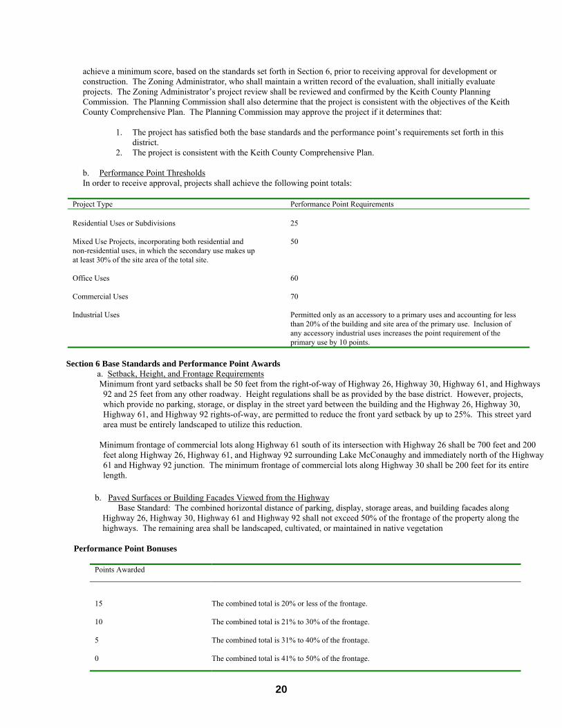
20
achieve a minimum score, based on the standards set forth in Section 6, prior to receiving approval for development or construction. The Zoning Administrator, who shall maintain a written record of the evaluation, shall initially evaluate projects. The Zoning Administrator’s project review shall be reviewed and confirmed by the Keith County Planning Commission. The Planning Commission shall also determine that the project is consistent with the objectives of the Keith County Comprehensive Plan. The Planning Commission may approve the project if it determines that:
1. The project has satisfied both the base standards and the performance point’s requirements set forth in this district.
2. The project is consistent with the Keith County Comprehensive Plan.
b. Performance Point Thresholds In order to receive approval, projects shall achieve the following point totals:
Project Type Performance Point Requirements Residential Uses or Subdivisions
25
Mixed Use Projects, incorporating both residential and non-residential uses, in which the secondary use makes up at least 30% of the site area of the total site.
50
Office Uses
60
Commercial Uses
70
Industrial Uses Permitted only as an accessory to a primary uses and accounting for less than 20% of the building and site area of the primary use. Inclusion of any accessory industrial uses increases the point requirement of the primary use by 10 points.
Section 6 Base Standards and Performance Point Awards
a. Setback, Height, and Frontage Requirements Minimum front yard setbacks shall be 50 feet from the right-of-way of Highway 26, Highway 30, Highway 61, and Highways
92 and 25 feet from any other roadway. Height regulations shall be as provided by the base district. However, projects, which provide no parking, storage, or display in the street yard between the building and the Highway 26, Highway 30, Highway 61, and Highway 92 rights-of-way, are permitted to reduce the front yard setback by up to 25%. This street yard area must be entirely landscaped to utilize this reduction.
Minimum frontage of commercial lots along Highway 61 south of its intersection with Highway 26 shall be 700 feet and 200
feet along Highway 26, Highway 61, and Highway 92 surrounding Lake McConaughy and immediately north of the Highway 61 and Highway 92 junction. The minimum frontage of commercial lots along Highway 30 shall be 200 feet for its entire length.
b. Paved Surfaces or Building Facades Viewed from the Highway Base Standard: The combined horizontal distance of parking, display, storage areas, and building facades along Highway 26, Highway 30, Highway 61 and Highway 92 shall not exceed 50% of the frontage of the property along the highways. The remaining area shall be landscaped, cultivated, or maintained in native vegetation
Performance Point Bonuses
Points Awarded
15 The combined total is 20% or less of the frontage.
10 The combined total is 21% to 30% of the frontage.
5 The combined total is 31% to 40% of the frontage.
0 The combined total is 41% to 50% of the frontage.

21
c. Landscaped Areas
Base Standard: All projects must provide a minimum landscaped area setback of 20 feet from the property line along Highway 26, Highway 30, Highway 61, and Highway 92, or any other public roadway and 5% interior landscaping within any parking lot that provides parking for more than 50 vehicles or open display area in excess of 15,000 square feet. The area of required landscaping shall be calculated according to the following formula:
Landscaped area = (20 x Frontage) + (.05 x parking or display lot area) Example: If a development is built along a 1,000 foot frontage and includes parking for 50 cars, its required landscaping is (1,000 x 20 feet) or 20,000 square feet plus 5% of the area of the parking lot.
Performance Points Bonuses
Points Awarded
20 Project provides 2 times the base standard of landscaped area.
15 Project provides 1.75 times the base standard of landscaped area.
10 Project provides 1.5 times the base standard of landscaped area.
5 Project provides 1.25 times the base standard of landscaped area.
0 Project meets minimum standards.
d. Signage
Base Standard: For any individual lot or premise, signage shall comply with the standards established by Table 6d. In the Entryway District, all detached signs shall be monument or ground signs.
Table 6d Base Standards for Signs
Use Total Sign
Budget per Premise
(square feet)
Maximum Total Signage per
Premise (square feet)
Detached Signs per Premise
Maximum Size for Detached
Sign
Maximum Wall Area for
Attached Signs
Maximum Sign Height for
Detached Signs
Single-Family
Residential 4 4 0 4 4 square feet 6
Multi-family Residential or Subdivision
Entrance Sign
32 32 1 32 32 square feet 8
Office or Mixed Use
0.5 x Street Frontage
200 1 per 500 feet of frontage
100 10% of wall area
12
Commercial 1.0 x Street Frontage
400 1 per 500 feet of frontage
150 20% of wall area
15
Performance Point Bonuses
Points Awarded
20 Total sign area = 20% or less of permitted sign area
15 Total sign area = 20% to 40% of permitted sign area
22
10 Total sign area = 40% to 60% of permitted sign area
5 Total sign area = 60% to 80% of permitted sign area
0 Total sign area = 80% to 100% of permitted sign area
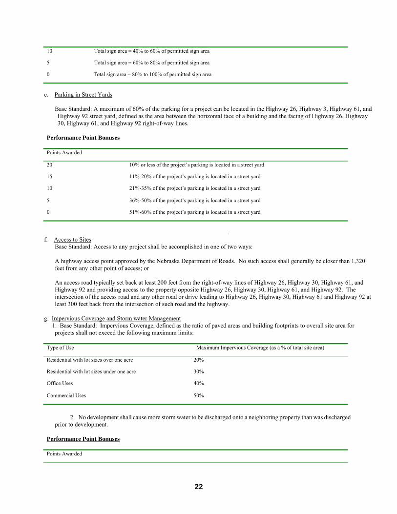
e. Parking in Street Yards
Base Standard: A maximum of 60% of the parking for a project can be located in the Highway 26, Highway 3, Highway 61, and Highway 92 street yard, defined as the area between the horizontal face of a building and the facing of Highway 26, Highway 30, Highway 61, and Highway 92 right-of-way lines.
Performance Point Bonuses
Points Awarded
20 10% or less of the project’s parking is located in a street yard
15 11%-20% of the project’s parking is located in a street yard
10 21%-35% of the project’s parking is located in a street yard
5 36%-50% of the project’s parking is located in a street yard
0 51%-60% of the project’s parking is located in a street yard
.
f. Access to Sites Base Standard: Access to any project shall be accomplished in one of two ways:
A highway access point approved by the Nebraska Department of Roads. No such access shall generally be closer than 1,320 feet from any other point of access; or An access road typically set back at least 200 feet from the right-of-way lines of Highway 26, Highway 30, Highway 61, and Highway 92 and providing access to the property opposite Highway 26, Highway 30, Highway 61, and Highway 92. The intersection of the access road and any other road or drive leading to Highway 26, Highway 30, Highway 61 and Highway 92 at least 300 feet back from the intersection of such road and the highway.
g. Impervious Coverage and Storm water Management
1. Base Standard: Impervious Coverage, defined as the ratio of paved areas and building footprints to overall site area for projects shall not exceed the following maximum limits:
Type of Use Maximum Impervious Coverage (as a % of total site area)
Residential with lot sizes over one acre 20%
Residential with lot sizes under one acre 30%
Office Uses 40%
Commercial Uses 50%
2. No development shall cause more storm water to be discharged onto a neighboring property than was discharged prior to development.
Performance Point Bonuses
Points Awarded
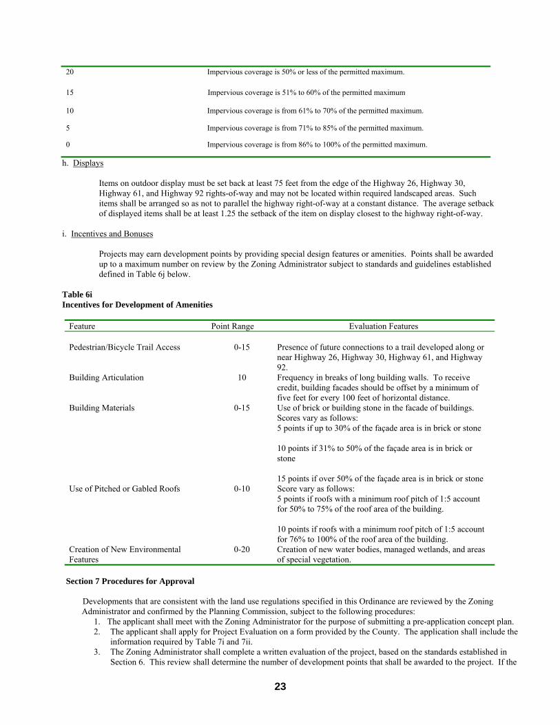
23
20 Impervious coverage is 50% or less of the permitted maximum.
15 Impervious coverage is 51% to 60% of the permitted maximum
10 Impervious coverage is from 61% to 70% of the permitted maximum.
5 Impervious coverage is from 71% to 85% of the permitted maximum.
0 Impervious coverage is from 86% to 100% of the permitted maximum.
h. Displays
Items on outdoor display must be set back at least 75 feet from the edge of the Highway 26, Highway 30, Highway 61, and Highway 92 rights-of-way and may not be located within required landscaped areas. Such items shall be arranged so as not to parallel the highway right-of-way at a constant distance. The average setback of displayed items shall be at least 1.25 the setback of the item on display closest to the highway right-of-way.
i. Incentives and Bonuses
Projects may earn development points by providing special design features or amenities. Points shall be awarded
up to a maximum number on review by the Zoning Administrator subject to standards and guidelines established defined in Table 6j below.
Table 6i Incentives for Development of Amenities
Feature Point Range Evaluation Features Pedestrian/Bicycle Trail Access 0-15 Presence of future connections to a trail developed along or
near Highway 26, Highway 30, Highway 61, and Highway 92.
Building Articulation 10 Frequency in breaks of long building walls. To receive credit, building facades should be offset by a minimum of five feet for every 100 feet of horizontal distance.
Building Materials 0-15 Use of brick or building stone in the facade of buildings. Scores vary as follows: 5 points if up to 30% of the façade area is in brick or stone 10 points if 31% to 50% of the façade area is in brick or stone 15 points if over 50% of the façade area is in brick or stone
Use of Pitched or Gabled Roofs 0-10 Score vary as follows: 5 points if roofs with a minimum roof pitch of 1:5 account for 50% to 75% of the roof area of the building. 10 points if roofs with a minimum roof pitch of 1:5 account for 76% to 100% of the roof area of the building.
Creation of New Environmental Features
0-20 Creation of new water bodies, managed wetlands, and areas of special vegetation.
Section 7 Procedures for Approval
Developments that are consistent with the land use regulations specified in this Ordinance are reviewed by the Zoning Administrator and confirmed by the Planning Commission, subject to the following procedures:
1. The applicant shall meet with the Zoning Administrator for the purpose of submitting a pre-application concept plan. 2. The applicant shall apply for Project Evaluation on a form provided by the County. The application shall include the
information required by Table 7i and 7ii. 3. The Zoning Administrator shall complete a written evaluation of the project, based on the standards established in
Section 6. This review shall determine the number of development points that shall be awarded to the project. If the

24
project earns the required number of points, the Zoning Administrator shall issue a Certificate of Conditional Approval of the project. The Planning Commission shall review this Certificate as part of the approval process. The Planning Commission’s review and approval of a project shall be based on its factual review of the findings of the Zoning Administrator: and its findings of the project’s consistence with the Lake Corridor Land Use Plan. All subsequent building and development permits shall be issued in concordance with the approved development plan.
4. A denial of the project based on failure to earn the required number of development points or inconsistency with the Land Use Plan shall be transmitted to the applicant. The applicant may either modify the project or appeal the decision of the Zoning Administrator or the Planning Commission to the Keith County Board of Adjustment. Protestors of the project may also appeal a finding of the Planning Commission by submission of a valid protest petition.
5. In the event of appeal, the Board of Commissioners, after proper notice, shall hold a public hearing and act upon the application. Proper notice shall mean the same notice established for a zoning amendment.
Table 7i
Application Requirements within the Entryway Corridor Planned Development Overlay District
Application Requirement Applications Consistent with Land Use
Regulations Location, size, legal description of site ■ Location and description of major site features, including tree masses, drainageways, wetlands, soils.
■
Location of 100-Year Floodplains ■ Generalized land use plan. ■ Proposed types and densities of development. ■ Generalized internal and external transportation and circulation system, including pedestrian and bicycle system.
■
Statistical summary of the project, including gross and net site area, number of housing units by type, gross floor area of other uses, total amount of parking, and building and impervious surface coverages.
■
Site master plan, including general envelopes of buildings, parking, open space, and other site features.
■
Description and location of all use types included in the project, including maximum floor areas devoted to each use.
■
Location and design of vehicular, bicycle, and pedestrian circulation systems, including relationship to external transportation system.
■
Schematic location and development standards for open space, including conceptual landscape plan.
■
Grading plan, including erosion control plans. ■ Location of existing and proposed utilities, sanitary sewers, storm water facilities, and water, gas, and electrical distribution systems.
■
General locations and sizes of signs and street graphics. ■
■ Required for all applications � Required if submitted for credit toward development points
25
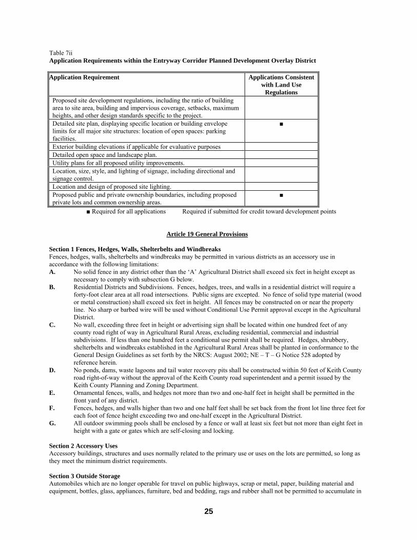
Table 7ii Application Requirements within the Entryway Corridor Planned Development Overlay District
Application Requirement Applications Consistent with Land Use
Regulations Proposed site development regulations, including the ratio of building area to site area, building and impervious coverage, setbacks, maximum heights, and other design standards specific to the project.
�
Detailed site plan, displaying specific location or building envelope limits for all major site structures: location of open spaces: parking facilities.
■
Exterior building elevations if applicable for evaluative purposes � Detailed open space and landscape plan. � Utility plans for all proposed utility improvements. Location, size, style, and lighting of signage, including directional and signage control.
�
Location and design of proposed site lighting. � Proposed public and private ownership boundaries, including proposed private lots and common ownership areas.
■
■ Required for all applications � Required if submitted for credit toward development points
Article 19 General Provisions
Section 1 Fences, Hedges, Walls, Shelterbelts and Windbreaks Fences, hedges, walls, shelterbelts and windbreaks may be permitted in various districts as an accessory use in accordance with the following limitations: A. No solid fence in any district other than the ‘A’ Agricultural District shall exceed six feet in height except as
necessary to comply with subsection G below. B. Residential Districts and Subdivisions. Fences, hedges, trees, and walls in a residential district will require a
forty-foot clear area at all road intersections. Public signs are excepted. No fence of solid type material (wood or metal construction) shall exceed six feet in height. All fences may be constructed on or near the property line. No sharp or barbed wire will be used without Conditional Use Permit approval except in the Agricultural District.
C. No wall, exceeding three feet in height or advertising sign shall be located within one hundred feet of any county road right of way in Agricultural Rural Areas, excluding residential, commercial and industrial subdivisions. If less than one hundred feet a conditional use permit shall be required. Hedges, shrubbery, shelterbelts and windbreaks established in the Agricultural Rural Areas shall be planted in conformance to the General Design Guidelines as set forth by the NRCS: August 2002; NE – T – G Notice 528 adopted by reference herein.
D. No ponds, dams, waste lagoons and tail water recovery pits shall be constructed within 50 feet of Keith County road right-of-way without the approval of the Keith County road superintendent and a permit issued by the Keith County Planning and Zoning Department.
E. Ornamental fences, walls, and hedges not more than two and one-half feet in height shall be permitted in the front yard of any district.
F. Fences, hedges, and walls higher than two and one half feet shall be set back from the front lot line three feet for each foot of fence height exceeding two and one-half except in the Agricultural District.
G. All outdoor swimming pools shall be enclosed by a fence or wall at least six feet but not more than eight feet in height with a gate or gates which are self-closing and locking.
Section 2 Accessory Uses Accessory buildings, structures and uses normally related to the primary use or uses on the lots are permitted, so long as they meet the minimum district requirements. Section 3 Outside Storage Automobiles which are no longer operable for travel on public highways, scrap or metal, paper, building material and equipment, bottles, glass, appliances, furniture, bed and bedding, rags and rubber shall not be permitted to accumulate in

26
any zoning district, except the ‘A’ Agricultural District, unless otherwise provided herein, or unless they are screened from public view from adjacent properties, streets, roads, or highways. Section 4 Supplementary Lot Area and Lot Width Regulations A. Where an individual lot was held in separate ownership from adjoining properties, or was platted prior to the
effective date of this resolution in a recorded subdivision and has less area or less width than required in other sections of this resolution, such a lot may be occupied according to the permitted uses provided for the district in which the lot is located. Yard setbacks may be adjusted by the Zoning Administrator by finding that the requested yard setbacks are appropriate and conforming to the general yard setbacks of the surrounding properties.
B. For the purpose of complying with the provisions of this resolution, no part of an area or width of a lot shall be included as an area or width required for another lot.
C. No lot shall have a front lot line of street frontage of less than forty feet, unless approved by the Keith County Planning Commission and the Keith County Board of County Commissioners.
D. All lots shall have a minimum depth to width ratio of no more than 3 times the depth to the 1 times the width. Section 5 Supplementary Yard Regulations A. Accessory buildings: Permitted accessory buildings may occupy no more than 50% of the required side and rear
yard setbacks, provided such accessory buildings are located at least five feet from any property line and located at least six feet from another building.
B. Architectural features: Cornices, canopies, eaves or similar architectural features may extend into a required yard not more than two feet.
C. Developed areas: In any district where lots comprising 50% or more of the frontage on one side of a street between intersecting streets have been improved with buildings at the time of passage of this resolution, the average front yard setback of such buildings shall be the minimum front yard setback required for all new construction in such block. In no instance shall the setback be less than ten feet.
D. Fire escapes: Fire escapes may extend into a required yard not more than six feet. E. Patios and uncovered porches: Patios and uncovered, unenclosed porches may extend into a required front or
rear yard not more than six feet and a side yard of not more than three feet. F. Reduction: No part of a yard required for any building for the purpose of complying with the provisions of this
resolution shall be included as a yard for another building and all yards shall be open and unobstructed except as otherwise provided herein.
G. There shall be no more than one (1) accessory building greater than 300 square feet in size per residential lot. H. Where a portion of an accessory building is converted to living quarters:
1. Those living quarters shall meet the minimum square footage requirements (801) for a single family dwelling.
2. Those living quarters shall meet the requirements of the residential building code adopted by Keith County.
3. The accessory building, in total, shall then meet the minimum setback requirements for a single family dwelling in that zoning district.
Section 6 Supplementary Building Height Regulations A. All dwellings shall be constructed with at least 50% of the roof surface higher than seven (7) feet from grade. B. It shall be unlawful to construct, build or establish any buildings, trees, smokestacks, chimney, flagpole, wire,
tower or other structure or appurtenance thereto which may constitute a hazard or obstruction to the safe navigation, landing and take off of aircraft at a public used airport.
C. Approvals of buildings of heights greater than permitted herein may occur when approved by the County with a Conditional Use Permit.
Section 7 Non-Conforming Uses and Buildings Except as otherwise provided in this resolution, the lawful use, location, height and size of any building or parcel of land existing at the time of enactment of this resolution, or of any amendments to this resolution, may be continued even though such use, location, height or size does not conform to the requirements of the resolution. The following conditions shall apply to such non-conforming use: A. Ordinary repairs and maintenance of a non-conforming building shall be permitted. Said repairs and
maintenance shall in no way make the building less conforming than exists prior to such repairs and maintenance.
B. A non-conforming building that has been damaged by fire or other natural causes may be restored to its original condition or level of non-conformity.

27
C. A non-conforming use may be changed to a use that is more conforming. (Example: an industrial use in a residential area could be changed to commercial use and be considered more nearly conforming to the residential district uses).
D. A non-conforming use or building cannot be expanded in any way that expands the degree of non-conformity (except the use may be expanded within the same building if the building was designed for such expansion and no structural alterations are required).
E. When a non-conforming use of land, building, structure, location, height, or size is abandoned or discontinued for a period of five years in the Agricultural District or twelve months in any other zoning district, the herein stated right to continue as a Non-Conforming Use shall be forfeit. Any further use of the land, building, structure, location, height, size or actives shall conform to the provisions of this ordinance.
F. Due process: when it is observed and reported to the Keith County Zoning Administrator that a non-conforming use is abandoned or discontinued, the owners of record for such use, building, structure, location, height, or size shall be notified by certified mail within thirty (30) days of the report of the statutory time lines established in Article 19 Section 7E.
These regulations shall not apply to a Lot of Record at the time of adoption of these regulations. Section 8 Utility Substations and Transmission Lines Utility substations and transmission lines are permitted in all districts so long as they are required and permitted by and meet the regulations of the Nebraska Public Service Commission and the Nebraska Power Review Board. Section 9 Governmental Facilities Recognizing that there are instances when governmental facilities are necessary to serve the public, governmental facilities are permitted in all districts with the assumption that the governmental agency will take the surrounding land uses into consideration when designing the location of the facilities. Section 10 Temporary Uses A. A temporary permit may be obtained from the Planning Commission (or its authorized staff representative)
upon the filing of an application requesting a temporary use and accompanied with an application fee. Temporary stands, structures, motor vehicles and trailers shall be removed on the date of termination of the permit unless a specific date is stated herein. Temporary structures shall be shown to be so constructed as not to constitute a fire hazard or hazard to the health or safety of the public prior to issuance of the permit. Such temporary stands or structures shall not be constructed of materials which are substantially deteriorated, nor shall any of the above temporary stands, structures, motor vehicles or trailers be allowed to deteriorate to the point where they shall constitute a fire or other hazard to the health, safety or welfare of the public.
B. The following uses may be allowed by temporary permit and need not be enclosed within a building: 1) Temporary construction yard or building for construction materials and equipment, mobile homes for office
use, and concrete batch plants, when incidental and necessary for construction. Each permit shall specify the location of the building, mobile home office, yard or batch plant.
2) Temporary office incidental and necessary for the sale of new construction by the permittee. Each permit shall specify the location of the office and the area within which such sales may be made.
3) Mobile homes may be used for temporary living quarters incidental and necessary for the construction of a residence on the property.
4) Each permit shall be valid for a period of not more than six calendar months and may be renewed for three successive six months period at the same location.
C. Temporary group assemblages of five hundred of more persons and on public or private lands not currently improved for such group assembly (improved means having adequate improved parking, permanent restrooms, permanent water supply and permanent fixed buildings or structures to house a large group) shall only permitted after public hearing has been held by the County Commissioners and they have approved, or conditionally approved, the request for such temporary use shall be submitted at least thirty days (30) prior to said assemblage to the County Clerk who shall set a hearing date and notify property owners. The application should include the written authorization of the property owners, a legal description of the property, a description of the proposed use or activity and a description of the facilities to be provided to serve the crowd; example: water, restrooms, parking, trash collection and removal, police protection and others as may be appropriate. An application fee shall be submitted with the request. The fee may later be returned in part or in total if so ordered by the County Commissioners. The County Commissioners shall, after hearing the matter, approve with conditions or deny the request. Conditions of approval if applied may include those conditions deemed necessary to protect the public health, safety and welfare.
Section 11 Home Occupations

28
A home occupation may be allowed as a permitted accessory use provided all of the following conditions are met; A. Such use shall be conducted entirely within a dwelling and carried on by the inhabitants living there and no
others. B. Such use shall be clearly incidental and secondary to the use of the dwelling for the dwelling purposes and shall
not change the character thereof. C. The total area used for such purposes shall not exceed one-half the floor area of the user’s dwelling unit. D. Any sign shall be limited to a two foot square, non-illuminated, non-animated sign attached to the dwelling
except in Agriculture District. E. There shall be only incidental sale of stock, supplies, or products of the use conducted on the premises. F. There shall be no exterior storage on the premises of material or equipment used as a part of the home
occupation. G. There shall be no offensive noise, vibration, smoke, dust, odors, heat, or glare noticeable at or beyond the
property line. H. A home occupation shall provide additional off street parking area adequate to accommodate all needs created
by the home occupation. I. In particular, a home occupation may include, but not limited to the following, provided all requirements
contained herein are met: art studio, beauty and barber shops, dressmaking or millinery work, professional offices, teaching, and bed and breakfasts renting rooms to no more than two persons per dwelling in the Residential Rural and Residential Rural Two Districts and four persons in the Agricultural District.
J. A home occupation shall not be interpreted to include the following: photo studios, dance studios, antique sales, animal hospitals or clinics, medical or dental clinics, mortuaries, any type of solely retail sales, display showrooms, restaurants and animal grooming parlors.
Section 12 Lake Area The Keith County-Lake McConaughy area provides a natural setting for wildlife and yet provides recreation for the people. The following standards are intended to accomplish the following:
Preserve the open space required for the wildlife of the area. Control traffic upon streets and roads. Preserve an individual site's natural characteristics. Provide for orderly development. Encourage integrated planning to achieve the objectives of the Keith County Comprehensive Plan. Protect the water quality and quality of the Lake area.
A. Standards:
The standards contained in Article 19 Section 12 of the Keith County Zoning Regulations shall apply to portions of the following areas of Keith County: o Sections 3, 7, 8, 9, an 10 - Township 14 North - Range 39 West o Sections 2, 3, and 12 - Township 14 North - Range 39 West o North ½ of Section 11 - Township 14 North - Range 39 West o North ½ and the North ½ of the South ½ of Sections 4, and 5 - Township 14 North - Range 39 West o Sections 32, and 33 - Township 15 North - Range 39 West o North ½ and the North ½ of the South ½ of Section 31 - Township 15 North - Range 39 West o North ½ and the North ½ of the South ½ of Section 36 - Township 15 North - Range 40 West o Sections 16, 17, 18, 21, 22, 23, 25, and 26 - Township 15 North - Range 40 West o North ½ of Section 27 - Township 15 North - Range 40 West o North ½ of Sections 19, and 20 - Township 15 North - Range 40 West o North ½ of Section 24 - Township 15 North - Range 41 West o Section 8, 9, 10, 11, 13, and 14 - Township 15 North - Range 41 West o North ½ of the North ½ of Section 16 - Township 15 North - Range 41 West o North ½ of Section 15 - Township 15 North - Range 41 West o All areas south of Nebraska highway 92 and north of the 3282 foot high-water elevation of Lake McConaughy o All areas south of the Union Pacific Rail Road right of way in Section 21 - Township 15 North - Range 38 West o Sections 28, and 34 - Township 15 North - Range 38 West o South ½ of the South ½ and the West ½ of the West ½ of Section 27 - Township 15 North - Range 38 West
The above areas shall hereinafter be referred to as the Lake Area.
B. Open space shall be established within subdivisions within the Lake area. Open space is defined as land upon which no structures, fences nor hedges may be placed, and over which the general public may have access.
C. Within the Lake area, the condition shall determine, based upon the terrain and contour of the site, the spacing
29
and the type of open space shall be determined by the formula contained in the Large Scale Development Overlay District of the Keith County Zoning Regulations.
D. Before approval by the Commission use of the open space, for pedestrian use only, for vehicular use only, or both, must be determined.
E. All roads within a subdivision within the lake area must lead from a public road and must comply with the road standards of Keith County that are in effect at the time.
Section 13 – Well Head Protection Areas Within those Well Head Protection Areas approved and regulated by the Nebraska Department of
Environmental Quality, any proposed septic systems, sanitary waste water systems, animal feeding operations (both confined and open), sanitary land fills, slaughter houses, livestock auction houses, or similar use that may contaminate the ground water, shall only be allowed under Article 20 – Conditional Uses Permitted by Special Review.
Intent: It is the intent of this Section to promote the safe, effective and efficient use of commercial and non commercial wind energy systems while protecting the public safety, welfare and economic base of Keith County. Section 14 – Wind Energy Systems Section 1. General Standards:
A. Clearance of rotor blades or airfoils for commercial/utility Wind Energy Systems (WES) must maintain a minimum of 20 feet of clearance between their lowest point and the ground. Non commercial WES shall have a minimum clearance of 12 feet between their lowest point and the ground. B. On site signage shall be limited to identification signs not to exceed six feet and high voltage warning signs.
C. All wind turbines part of a commercial/utility WES shall be installed with a monopole tower. D. All commercial/utility WES shall obtain a FAA permit and comply with all aviation warning requirements established by the FAA regulations and permit. E. All commercial/utility WES shall be white, grey or other neutral non obtrusive, non reflective color. Blades may be black in order to facilitate deicing. F. All on site communication and transmission feeder lines installed as part of the commercial/utility WES shall be underground. G. Commercial/utility WES shall not exceed 50 dba at the nearest occupied dwelling. H. Commercial/utility WES shall obtain FCC permits where necessary and provide evidence of permit approval. I. The commercial/utility WES, at the time of application for a conditional use, shall identify all county roads to be used for construction and maintenance of a WES. The Conditional Use applicant in coordination with the Keith County Highway Superintendent shall conduct a road condition survey and written report prior to construction. The Conditional Use applicant shall be responsible for restoration of the road(s) and bridges to preconstruction standards as established in the report. The Applicant shall be responsible for the cost of retaining outside engineering firm(s) to evaluate road condition and cost for restoration if so determined by the Keith County Planning Commission. J. The commercial/utility WES applicant shall be responsible for immediate repair of damage to drainage or irrigation systems stemming from construction, operation or maintenance of the WES. K. Solid and hazardous wastes, including but not limited to crates, packaging materials, damaged or worn parts, as well as oils, lubricants and solvents shall be removed from the site promptly and disposed of in accordance with all applicable local, state and federal regulations. L. A commercial/utility WES shall provide a decommissioning plan to the Keith County Board of Commissioners at the time application is made. The plan shall include the method or means of removing the WES and accessory facilities, parties responsible for removal and site cleanup, evidence of a damage insurance liability policy, schedule for removal not to exceed ninety (90) days from approval of the plan. The Applicant shall set aside ¾ of 1% of each towers’ cost for future decommissioning upon approval of the application by the Keith County Board of Commissioners. The funds are to be placed in a cash escrow account with a local Keith County Bank. All Wind Energy Commercial Systems and accessory facilities shall be removed to four (4) feet below ground level within 180 days of the discontinuation of use. This period may be extended by the Keith County Zoning Administrator following a written request by the owner of the Wind Energy System. M. A conditional use permit for a commercial/utility WES shall be reviewed each year on the anniversary of issuance. A Conditional Use permit for a commercial/utility WES shall be considered null and void if the WES has not begun within one year following issuance of the WES Conditional Use Permit or produced energy for one year, unless a plan is submitted to the Keith County Planning and Zoning Office outlining the steps and schedule for returning the WES to service. N. A contractual agreement referred to as a Developers Agreement between Keith County and the Commercial WES developer shall be created and made part of the Conditional Use permit. The Agreement shall detail, road improvements, road reconstruction, additional ROW needs, location of transmission lines, easements, bond and
30
payment requirements.
Section 2. Non Commercial WES A. Shall be systems installed to provide for full or partial onsite consumption of utility supplied electricity. B. Setbacks: Non Commercial WES shall be located in the rear yard of all Residential Districts, further; all towers shall adhere to the setbacks found in Table 2. C. Tower Height: In all districts except the Agricultural District tower heights shall not exceed 30 feet. Any tower exceeding 30 feet shall be required to submit an application for conditional use. In the Agricultural District there is no height limitation except that imposed by FAA regulations. D. Non Commercial WES shall not exceed 50 dba, as measured at the closest neighboring inhabited dwelling unit. Temporary exceptions may include severe wind storms or power outages requiring higher demand. E. Compliance with Keith County Building Code: 1. All Non Commercial WES will require a building permit.
2. Permit application will include an engineered drawing showing compliance with nationally recognized building codes. The permit shall include standard drawings of the tower structure, turbine structure, footings, guy wire anchors and a professional engineers stamp. 3. Evidence of Notification to the servicing utility informing the utility that the Non Commercial WES will be connected to the utilities grid. 4. Evidence that Non Commercial WES, when located within 1,320 feet of Lake McConaughy, Lake Ogallala, North Platte and South Platte Rivers, has complied with the requirements found in Checklist #1.
Section 3. Meteorological Towers
A. Shall be towers which are erected primarily to measure wind speed, direction, and record other data relevant to the site of a Commercial WES.
B. Meteorological towers shall be sited according to Table 1. C. Meteorological towers shall be a Conditional Use and follow the same process as outlined in Section 4B.
D. Meteorological Towers, permanent or temporary, in excess of 200 feet in height, shall meet all FAA requirements and shall be required to apply for a building permit prior to construction. Meteorological towers less than 200 feet in height shall have the guy wires clearly marked with devices common to overhead transmission lines and shall be required to apply for a building permit prior to construction. E. Setbacks: all Meteorological Towers shall adhere to the set back established in
Table 2. Section 4. Commercial/Utility
A. Commercial/Utility WES shall be permitted as Conditional Uses within the districts as seen in Table 1. B. The request for Conditional Use shall include the following:
1. Name(s) of project applicant. 2. Name(s) of project owner. 3. Legal description of the project. 4. Documentation of land ownership or lease of the property. 5. Site plan showing property lines, setbacks, proposed accessory buildings, wind turbine
locations, transmission lines, adjacent subdivisions, homes or other structures, county and service roads, legend and scale, signature of surveyor or engineer.
6. Narrative description of the project including number, type, generating capacity, tower height, rotor diameter, total height of all wind turbines including meteorological towers, height of transmission lines and capacity, lastly proposed users of project.
7. Overview map of the area showing topography, location of WES owned or not owned by the applicant, public or private airfields within one mile of the proposed WES and other communication towers.
8. An acoustical report that certifies the WES will meet the noise requirements of this ordinance. 9. Evidence that other tower owners or lessees have been notified of the proposed WES and
there will not be interference in communications. 10. An Environmental Assessment Worksheet shall be prepared by a qualified environmental
engineering firm when a Commercial WES is located within Avian migratory routes. The ‘EAW’ shall contain an avian assessment, map of the migratory routes and recommended mitigation practices.
11. A decommissioning plan as required by this ordinance in Section 1L.
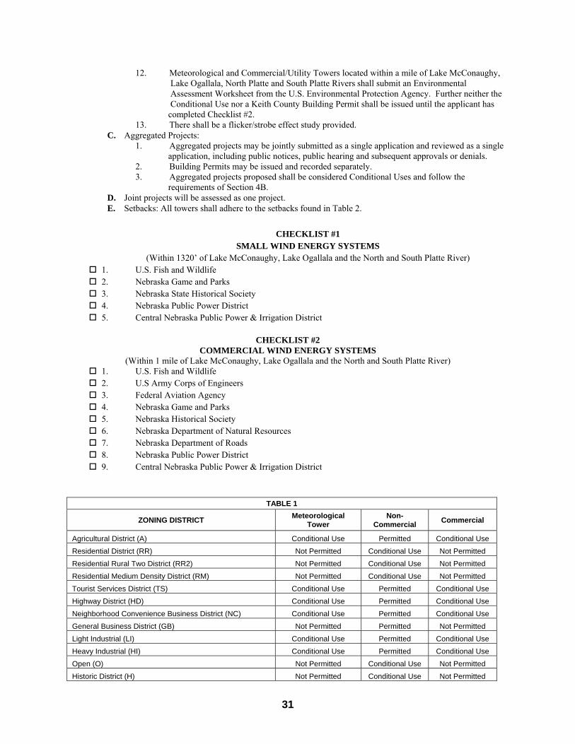
31
12. Meteorological and Commercial/Utility Towers located within a mile of Lake McConaughy, Lake Ogallala, North Platte and South Platte Rivers shall submit an Environmental Assessment Worksheet from the U.S. Environmental Protection Agency. Further neither the Conditional Use nor a Keith County Building Permit shall be issued until the applicant has completed Checklist #2.
13. There shall be a flicker/strobe effect study provided. C. Aggregated Projects:
1. Aggregated projects may be jointly submitted as a single application and reviewed as a single application, including public notices, public hearing and subsequent approvals or denials.
2. Building Permits may be issued and recorded separately. 3. Aggregated projects proposed shall be considered Conditional Uses and follow the
requirements of Section 4B. D. Joint projects will be assessed as one project. E. Setbacks: All towers shall adhere to the setbacks found in Table 2.
CHECKLIST #1
SMALL WIND ENERGY SYSTEMS (Within 1320’ of Lake McConaughy, Lake Ogallala and the North and South Platte River)
1. U.S. Fish and Wildlife 2. Nebraska Game and Parks 3. Nebraska State Historical Society 4. Nebraska Public Power District 5. Central Nebraska Public Power & Irrigation District
CHECKLIST #2
COMMERCIAL WIND ENERGY SYSTEMS (Within 1 mile of Lake McConaughy, Lake Ogallala and the North and South Platte River)
1. U.S. Fish and Wildlife 2. U.S Army Corps of Engineers 3. Federal Aviation Agency 4. Nebraska Game and Parks 5. Nebraska Historical Society 6. Nebraska Department of Natural Resources 7. Nebraska Department of Roads 8. Nebraska Public Power District 9. Central Nebraska Public Power & Irrigation District
TABLE 1
ZONING DISTRICT Meteorological
Tower Non-
Commercial Commercial
Agricultural District (A) Conditional Use Permitted Conditional Use
Residential District (RR) Not Permitted Conditional Use Not Permitted
Residential Rural Two District (RR2) Not Permitted Conditional Use Not Permitted
Residential Medium Density District (RM) Not Permitted Conditional Use Not Permitted
Tourist Services District (TS) Conditional Use Permitted Conditional Use
Highway District (HD) Conditional Use Permitted Conditional Use
Neighborhood Convenience Business District (NC) Conditional Use Permitted Conditional Use
General Business District (GB) Not Permitted Permitted Not Permitted
Light Industrial (LI) Conditional Use Permitted Conditional Use
Heavy Industrial (HI) Conditional Use Permitted Conditional Use
Open (O) Not Permitted Conditional Use Not Permitted
Historic District (H) Not Permitted Conditional Use Not Permitted

32
Entryway Corridor Planned Development District (ECPD Conditional Use Conditional Use Not Permitted
TABLE 2
Setbacks All towers shall adhere to the setbacks established in the following table:
Wind Turbine-Non Commercial
Commercial and Utility WES
Meteorological Towers
Property lines 1.1 times the total height. 1/2 blade diameter or 150',
whichever is greater. 1.1 times the tower height.
All Road Rights-of-Way** 1.1 times the total height. 1/2 blade diameter or 150',
whichever is greater. 1.1 times the tower height.
Other Public or Private Utility Easements 1.1 times the total height.
1/2 blade diameter or 150', whichever is greater. 1.1 times the tower height.
Public and Private Airfields Per FAA regulations Per FAA regulations Per FAA regulations
Lake McConaughy and Lake Ogallala Within 1,320' of Central
R.O.W. See Checklist #1. Within 1 mile of Central
R.O.W. See Checklist #2.
Within 1 mile of Central R.O.W. See Checklist #2.
South Platte and North Platte River Within 1,320' of top of
riverbank. See Checklist #1.
Within 1 mile of top of riverbank. See Checklist
#2.
Within 1 mile of top of riverbank. See Checklist
#2.
Irrigation Canals 1.1 times the total height. 1/2 blade diameter or 150',
whichever is greater. 1.1 times the tower height.
*The setback for dwelling units shall be reciprocal in that no dwelling unit shall be constructed within the same distance required for a common Wind Energy System.
**The setback shall be measured from any future Rights-of-Way if a planned change or expanded right-of-way is known. Section 15 – Large Scale Development Section 1 Intent It is the intent of the Article to augment normal zoning requirements by achieving the following: A) To encourage innovations in residential, commercial and industrial development and renewal so that the
growing demands of the population may be met by greater variety in type, design and layout of buildings and by the conservation and more efficient use of open space ancillary to said buildings.
B) To encourage a more efficient use of land and of public services, or private services in lieu thereof, and to reflect changes on the technology of land development so that resulting economics may ensure the benefit of those who need homes.
C) To lessen the burden of traffic on streets and highways. D) To encourage the building of new neighborhoods incorporating the best features of modern design. E) To conserve the value of the land. F) To provide a procedure that will relate the type, design and layout of residential, commercial and industrial
development to the particular site, thereby encouraging preservation of the sites natural characteristics. G) To encourage integrated planning in order to achieve the above purposes and in order to achieve the objectives
of the Keith County Comprehensive Plan. Section 2 General Requirements The owner or owners of any tract of land may submit to the County a plan for the use and development thereof for residential, commercial, or industrial purposes in the appropriate districts with the following minimum area requirements: ‘A’ District - 75 acres or more in area, ‘RR’, ‘RR2’, or ‘RM’ Districts - 5 acres or more in area, ‘TS’, ‘HD’, ‘NC’, or ‘GB’ Districts - 5 acres or more in area, ‘LI’, or ‘HI’ Zoning District - 10 acres or more in area A large scale development in the ‘A’ Zoning District where cultivated land, grazing land, or environmental sensitive land

33
is preserved, and no new county roads are proposed, may receive a 10% density bonus. The design for such a large scale development shall accomplish the following objectives:
Preserve the rural character of the open fields and pastures and natural wooded areas; Preserve the natural habitats; Preserve natural drainage courses; and Preserve the existing natural topography.
A large scale development shall generally conform to the permitted uses allowed by the underlying district.
Section 3 Procedures A. All requests for large scale developments shall be processed under the Conditional Uses Permitted by Special
Review and the Subdivision Regulations. In addition to the information required therein, plans and details should be provided as needed to describe the project. The Planning Commission, if deemed necessary, can require additional information if needed to properly evaluate the proposed request.
B. If desired, the applicant may, prior to submitting complete plans, submit a general plan for the subject site. This general plan will define location and density of land uses, access and other schematic concepts to provide a general concept of the project. This general master plan shall be submitted to the Planning Commission for review and comment only. No official action will be taken. The review is for informational purposes only.
C. The final plan and development standards, after approval by the County, shall be recorded in the County Clerk and Register of Deeds office. Thereafter, all permits issued for development shall substantially conform to the approved recorded large scale development plans. Deviations from the recorded plans can only occur after reapplication, following the same procedure for new applications.
D. In those instances where land is also intended to be sold, the requirements of the Keith County Subdivision regulations shall also be met. To the extent logical, large scale development plans and subdivisions plans can be processed simultaneously.
Section 4 Standards The following standards and conditions shall apply to all large scale development plans: A. Public open space shall be dedicated, or developed as a private park based on the following formula:
Total Gross Density per acre X 2 + 5 = % of public space required. Gross density being total acreage inclusive of streets, cul-de-sacs, utility easements and other like or similar public dedications.
This public open space shall be used for public recreation and open space purposes only. In lieu of dedication of land as set forth hereinabove, the County Commissioners may decide to implement one or a combination of the following policies:
1) The County Commissioners may determine that the large scale development applicant shall pay the County in cash an amount based upon the average market value of the large scale development property and based upon the formula as set forth hereinabove. The fee shall be negotiated with the applicant and if the County and the applicant fail to agree on the value of the land, such value shall be fixed by a real estate appraisal by two (2) qualified appraisers who are acceptable to both the applicant and the County. If appraisals are required to satisfy negotiations, the cost of said appraisals shall be the applicant’s responsibility.
2) In lieu of dedicating land within the proposed site. The applicant may dedicate an alternate parcel of land, consisting of the same number of acres which would be required to be dedicated from the proposed large scale development site based upon the above formula, in another area to which he/she has title which, in the sole and exclusive opinion of the County Commissioners is capable of being utilized for public purposes. In any event, the County Commissioners shall make the final decision. In determining which of the policies to implement, the Planning Commission and County Commissioners shall consider the following: The site of the proposed large scale development and it’s adequacy for accommodating a public use
site; The public facility aspects of the County Comprehensive Plan; The applicable school districts master plan; The existing parking and other public uses in the area; The topography and geology; The location of land within the proposed large scale development available for public dedication; The needs of people in the area; and Any other appropriate factors.
B. Common and private open space shall also occur in large scale development areas at a rate not less than forty percent of the total size.
34
1) Common private open space as required herein is shared jointly by all large scale development owners and residents and can be used for recreation or visual open space, but is not used by the general public, and is considered to be that portion of the site not developed as public open space, building pads, storage areas, driveways and parking areas. This is usually areas surrounding the lots that are not a part of the developable lots, outlots surrounding townhouse lots, or outlots dedicated as open space.
2) Private open space as required herein is outdoor space deeded to an individual resident or owner (usually part of the developable lots) of the large scale development that may be used for personal recreation space, visual relief or for similar purposes by the owner of said space.
C. The applicant shall provide for and establish an organization for the ownership and maintenance of any common open space, or show that there are adequate arrangements for the ownership and maintenance thereof. Approval of the organizational concept shall be part of the approved large scale development plan.
D. To encourage development of private common area and facilities in a manner usable by adjacent residents, the following incentives shall be applicable: 1) Recreation buildings Each one square foot of building ground coverage is counted as two
square feet of open space. 2) Swimming pool (enclosed) Each one square foot of building ground coverage is counted as two
square feet of required open space. 3) Swimming pool (open) Each one square foot of water surface is counted as one and one-half
square feet of required open space. 4) Tennis court Each one square foot of court is counted as one and one-quarter square
feet of required open space. 5) Putting green Each one square foot of putting green is counted as two square feet of
required open space. 6) Tot lot or other play equipment Each one square foot of designated lot of equipment is counted as one and
one-quarter square feet of required open space. E. To encourage use of the large scale development concepts, and to recognize the fact that good residential
planning can effectively accommodate more people, densities may be increased in approved large scale developments over the density permitted outright in each zone at the rate of ten percent over the allowed number of dwelling units based on the underlying district.
E. If approved by the County, a residential large scale development may include mix of dwelling unit types, reduction in setbacks, and other waivers of zoning and subdivision requirements. Nothing noted in the regulations for the large scale development is a guarantee of reductions, adjustments, or waivers. Each large scale development must request the specific reductions, adjustments, and waivers, and each is judged and evaluated on the individual circumstance. Generally the design shall protect the welfare of existing and future residents within and adjacent to the project.
G. The application, when submitted, shall be accepted only when it includes the following information: 1) A certified boundary survey of adequate legal description of the property for which the application is made
to adequately define the location of the site. 2) Authorization from the property owner agreeing to submittal of the application if the owner is not the
applicant. 3) Date prepared, north arrow, scale, and location of section lines and section corners. 4) Contour lines at intervals not exceeding five feet based on U.S.G.S. data. Spot elevations on a 100-foot
grid shall be required to indicate the topography of flat land. 5) Locations, names, tangent lengths, center line radius of each curve and its interior angle and width of all
proposed and existing streets, highways, private roadways, and other public ways within and adjacent to the conditional use permit.
6) Location, width, and direction of flow of all watercourses in and adjacent to the conditional use permit, including the limits of any floodplain.
7) Location and size of all existing and proposed septic lines, storm sewer lines, water mains, culverts, fire hydrants and existing power lines and other underground structures or cables within the proposed development and adjacent streets and roads.
8) Lot lines and dimensions of lot lines 9) Lot numbers shall begin with the number 1 and shall continue consecutively through a block with no
omissions or duplications. Blocks shall be numbered in the same manner. Letters shall be used to designate outlots in alphabetical order.
10) Proposed areas of open space, both public and private. 11) Location, sizes, and uses of all proposed and existing buildings. 12) The following information shall be submitted with the large scale development:
a. The name of the large scale development;
35
b. The name, address and phone number of the developer; c. Record owner of the property; d. The name, address and phone number of the person or company responsible for the preparation of
the large scale development; e. Complete legal description certified by a surveyor or engineer including the number of acres in the
development; f. Statement of present zoning and proposed use or uses of the property; g. Profiles and grades of the proposed streets and private roadways; h. If a public or community septic system is proposed, the size and location of all proposed septic lines
including observation holes and any pump stations, and the location and type of any proposed community treatment facility;
i. If individual septic systems are proposed, percolation tests and data based on one test hole per proposed lot or certified information from a soil engineer indicating the estimated percolation rate and suitability of the soil;
j. If a public or community water system is proposed, the location and size of all proposed water mains, fire hydrants, storage facilities, and any extension to existing mains must be shown or to a proposed community well. In the case of a community water system, the proposed well locations, along with data from test wells based on a 10 acre grid of the entire development showing quality and quantity of the water obtained from the test wells, the type of water treatment to be used must be shown and documented. The results of these preliminary tests shall in no way guarantee the quality or quantity of the water to the individual lots and the data obtained shall not be used to imply that an adequate quantity or acceptable quality of water is available for the proposed large scale development;
k. A complete drainage study including a map of the drainage area and resulting run-off from all land lying outside the limits of the development which discharge storm water into or through the large scale development, a map showing all internal drainage areas and resulting run-off, proposals as to how the computed quantities of run-off will be handled, and the drainage calculations and computations;
l. A site grading plan showing existing and proposed contours; m. All deviations from the provisions of these regulations shall be fully noted and the reasons given for
said deviations. This shall not imply that the County will grant any deviations, but will evaluate the requests on an individual basis.
13) A statement regarding the applicants approach to providing and improving, if applicable, public roads, parks and other related public improvements.
14) Due to the unusual circumstances related to a particular request, or where an unusual hardship may occur, the Planning Commission or its authorized agent may waive any of the above application requirements. Waivers authorized by the authorized agent must be communicated to the Planning Commission and Board of County Commissioners. Waivers by the authorized agent do not preclude the Planning Commission or the County Commissioners from requiring said information at a later date.
G. An application fee as may be adopted by resolution of the County Commissioners shall be submitted to cover processing and hearing costs.
Section 16: Special Exceptions for Accessory Building setbacks: A. Whereby cause of geography or lots of record it is impractical to construct a permitted accessory building in the
rear or side yard as stipulated in Section 5 of this Article, the Planning Commission may make a special exception that permits an accessory building to be located in the front yard. In the case of corner lots the minimum front and side yard setbacks from the front and side property lines shall be forty (40) feet in order to maintain a sufficient sight triangle at the intersection.
B. A request for Special Exception to Section 5 shall adhere to the requirements found in Article 20 Sections 1, 2 and 3.
C. No more than one Accessory Building may be located in the required front yard.
Article 20 Conditional Uses Permitted by Special Review Section 1 Intent and Review Considerations A. Conditional uses are generally those types of uses which, under desirable conditions are allowable in the district
in which they are listed as conditional uses. The Planning Commission and the County Board shall consider the following in approving or denying a request for a conditional use permit:

36
1) Compatibility with the surrounding area. 2) Positive and negative short and long-range impacts of the proposed use. 3) The need for the use, especially at the requested location. 4) Compatibility of the proposed land uses designated in the Keith County Comprehensive Plan.
5) The uses effect on the health, safety and welfare of the inhabitants of the area and the County. 6) Compatibility with the intent of this resolution and specifically, the district in which the use is proposed.
7) If condition uses involving utility facilities shall become permanent upon approval, it shall be noted in the application.
B. It is understood that these conditional uses are not automatically approved after the required review. Conditions may arise which would find irresolvable conflicts between the proposed use and existing or long term use of the area and its impact on the neighborhood or the County. To the extent practical, conditions may be attached to the approval of a proposed use to assure compliance with the objectives of this resolution.
Section 2 Application Requirements A. All applications for a conditional use shall be submitted to the Planning Commission (or its authorized staff
representative) at least twenty days prior to a regular meeting of the Planning Commission. B. The application, when submitted, shall be accepted only when it includes the following information:
1) A certified boundary survey of adequate legal description of the property for which the application is made to adequately define the location of the site.
2) Authorization from the property owner agreeing to submittal of the application if the owner is not the applicant.
3) Date prepared, north arrow, scale, and location of section lines and section corners. 4) Contour lines at intervals not exceeding five feet based on U.S.G.S. data. Spot elevations on a 100-foot
grid shall be required to indicate the topography of flat land. 5) Locations, names, tangent lengths, center line radius of each curve and its interior angle and width of all
proposed and existing streets, highways, private roadways, and other public ways within and adjacent to the conditional use permit.
6) Location, width, and direction of flow of all watercourses in and adjacent to the conditional use permit, including the limits of any floodplain.
7) Location and size of all existing and proposed septic lines, storm sewer lines, water mains, culverts, fire hydrants and existing power lines and other underground structures or cables within the proposed development and adjacent streets and roads.
8) Location, sizes, and uses of all proposed and existing buildings. 9) The following information shall be submitted with the conditional use permit application:
a. The name of the conditional use permit; b. The name, address and phone number of the developer; c. Record owner of the property; d. The name, address and phone number of the person or company responsible for the preparation of
the conditional use permit; e. Complete legal description certified by a surveyor or engineer including the number of acres in
the development; f. Statement of present zoning and proposed use or uses of the property; g. Profiles and grades of the proposed streets and private roadways; h. If a public or community septic system is proposed, the size and location of all proposed septic
lines including observation holes and any pump stations, and the location and type of any proposed community treatment facility;
i. If individual septic systems are proposed, percolation tests and data based on one test hole per proposed lot or certified information from a soil engineer indicating the estimated percolation rate and suitability of the soil;
j. If a public or community water system is proposed, the location and size of all proposed water mains, fire hydrants, storage facilities, and any extension to existing mains must be shown or to a proposed community well. In the case of a community water system, the proposed well locations, along with data from test wells based on a 10 acre grid of the entire development showing quality and quantity of the water obtained from the test wells, the type of water treatment to be used must be shown and documented. The results of these preliminary tests shall in no way guarantee the quality or quantity of the water to the individual lots and the data obtained shall not be used to imply that an adequate quantity or acceptable quality of water is available for the proposed large scale development;
k. A complete drainage study including a map of the drainage area and resulting run-off from all
37
land lying outside the limits of the development which discharge storm water into or through the large scale development, a map showing all internal drainage areas and resulting run-off, proposals as to how the computed quantities of run-off will be handled, and the drainage calculations and computations;
l. A site grading plan showing existing and proposed contours; m. All deviations from the provisions of these regulations shall be fully noted and the reasons given
for said deviations. This shall not imply that the County will grant any deviations, but will evaluate the requests on an individual basis.
10) A statement regarding the applicants approach to providing and improving, if applicable, public roads, parks and other related public improvements.
11) Due to the unusual circumstances related to a particular request, or where an unusual hardship may occur, the Planning Commission or its authorized agent may waive any of the above application requirements. Waivers authorized by the authorized agent must be communicated to the Planning Commission and Board of County Commissioners. Waivers by the authorized agent do not preclude the Planning Commission or the County Commissioners from requiring said information at a later date.
C. An application fee as may be adopted by resolution of the County Commissioners shall be submitted to cover processing and hearing costs.
Section 3 Procedures A. Upon receipt of a complete application and application fee, the Planning Commission or its authorized staff
representative shall set the request for public hearing by publishing a description of the request and the time, date and place for hearing at least ten days prior to the scheduled hearing date. Adjacent property owners abutting or across the street (or alley) from the subject site, shall be notified in writing of the proposed request and scheduled hearing time, date and place. If, in opinion of the Planning Commission or its authorized agent, the proposed use could impact a much larger area, the notice may be extended. Current tax records shall be used to determine ownership. Should the applicant request a delay of hearing more than twice (2) after due notice to affected landowners and a publication in the official county newspaper, said applicant shall be required to pay a full fee for renewal of the Conditional Use by Special Permit or Zoning Map Amendment application.
B. The staff representative for the Planning Commission shall, prior to the hearing, accomplish the following: 1) Refer the request to other interested agencies and county departments for comment. 2) Prepare a staff report outlining findings and recommendations that will assist the Planning Commission in
making a decision in the matter. 3) Refer the report to the Planning Commission and the applicant at least three days prior to the scheduled
hearing date. C. The Planning Commission shall hear and review the matter and within thirty-five days of the first hearing, do
one of the following: 1) Recommend approval with or without conditions to the County Commissioners and reasons for approval. 2) Recommend denial to the County Commissioners and reasons for said denial. 3) Table the matter for a specified period of time with the consent of the applicant for further study and review.
D. The Planning Commission recommendations shall be forwarded to the County Commissioners along with the application file. Said recommendations shall be recorded in the Planning Commission meeting minutes or in some other written form for review by the County Commissioners.
E. The County Clerk shall set a hearing date before the County Commissioners and provide notification in the manner prescribed in Section 3 - A above.
F. The County Commissioners shall hear and review the matter and shall, within thirty-five (35) days of said hearing, do one of the following:
1) Approve the request. 2) Approve the request with conditions necessary to protect the public health, safety and welfare.
3) Deny the request. d) Table the matter for a specified period of time with the consent of the applicant for further study
and review. The reasons for the County Commissioner’s action on the request shall be defined in the official minutes of the
County Commissioners meeting. G. Within one year of the approval, construction on the proposed project shall have commenced or the approval is
void. However, the applicant may file a letter requesting an extension prior to the expiration of the initial approval. The Planning Commission shall review the extension request and recommend to the County Commissioners approval for a specified period up to twelve months or denial, indicating their reasons for such action.
H. The Planning Commission’s recommendation shall be forwarded to the County Commissioners for final
38
disposition. The County Commissioners shall then approve the extension up to a maximum of twelve months or deny the request, defining their reasons for such action.
I. No further extension shall be granted. After expiration, a new application is required if construction has not started and processed in the manner described herein and approved before the use could be developed.
J. Starting of construction after approval and prior to expiration and diligently pursuing it, permanently establishes the applicant’s rights to the approved use unless conditions of approval state otherwise.
Section 4 Sand, Gravel and Other Open Pit Mining Operations Standards The following minimum standards shall apply to all approved open-pit mining operations: A. The operator shall maintain haulage roads in a reasonably dust free condition if within one-forth mile of an
established residential subdivision. B. The hours of operation shall be limited to a period between 6:00 a.m. and 10:00 p.m. if the operation is located
within one-fourth mile of an established residential subdivision. C. Excavations shall occur no nearer than ten feet from any property line, nor nearer than one hundred fifty feet
from any residence, unless written consent of the owner of the residence or property is provided to the Planning Commission. Excavation shall occur not nearer than twenty-five feet from any public road.
D. The slopes of any excavation shall not exceed four feet horizontal to one-foot vertical (4:1) slope. E. The reclamation plan shall be submitted with the conditional use request. This plan shall include the following: 1) Use of the area after excavation. 2) Methods and type of renovation proposed.
3) Description of final grading concept that will remove rough contours, smoothing ridges, mounts, etc., into a more natural condition.
4) Any other plans of description that will further define the operator’s intent to reclaim the site. 5) A reclamation staging program.
6) A financial surety shall be required by the County as a condition of approval to ensure full compliance with condition of reclamation.
Section 5 Concentrated Animal Feeding Operations The following minimum standards shall apply to all approved confined animal feeding operations: A. The applicant must verify that the proposed concentrated animal feeding operation meets the license requirements and
waste disposal requirements of the State of Nebraska; B. All runoff or waste generated from any concentrated animal feeding operation shall be contained within the
associated farming operation, or, on the premises upon which the concentrated animal feeding operation is located. The applicant must verify that all runoff control ponds, lagoons, methods of manure disposal and use control measures are designed to minimize odor and air pollution, and avoid surface or groundwater contamination as regulated by the State of Nebraska and Keith County.
C. Wet Manure Operations shall not be located or allowed areas as denoted in Table 13 of the NRCS Soil Survey of Keith County, Nebraska as rated as having “severe” limitations.
Section 6 Accessory Uses On A Lot of Less Than 2 Acres Without A Primary Use The following requirements shall apply and be required for an application for a conditional use permit for an accessory use or uses on a lot of less than 2 acres without a primary use.
A. The accessory use or uses shall meet the minimum setbacks as required by the zoning district in which it is proposed.
B. The proposed future location of the primary use, septic system and well shall be indicated on the site plan. C. The complete interior layout of the accessory use or uses shall be provided. D. The applicant shall submit a time schedule for the construction of the primary building on the lot.
Article 21 Mobile Home Parks Section 1 Intent It is intended that the requirements for mobile home parks should be such that the quality of a neighborhood is not detrimentally affected by the adjacent location of a mobile home park. Since this form of housing contrasts substantially with typical on site constructed housing, it is necessary to review each request via the procedure of Article 20, Conditional Uses Permitted by Special Review. This review procedure allows design adjustments to fit the constraints of any site. Section 2 Development Standards
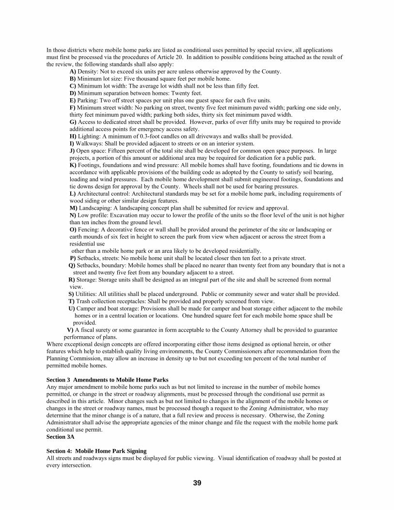
39
In those districts where mobile home parks are listed as conditional uses permitted by special review, all applications must first be processed via the procedures of Article 20. In addition to possible conditions being attached as the result of the review, the following standards shall also apply: A) Density: Not to exceed six units per acre unless otherwise approved by the County. B) Minimum lot size: Five thousand square feet per mobile home. C) Minimum lot width: The average lot width shall not be less than fifty feet. D) Minimum separation between homes: Twenty feet. E) Parking: Two off street spaces per unit plus one guest space for each five units.
F) Minimum street width: No parking on street, twenty five feet minimum paved width; parking one side only, thirty feet minimum paved width; parking both sides, thirty six feet minimum paved width.
G) Access to dedicated street shall be provided. However, parks of over fifty units may be required to provide additional access points for emergency access safety.
H) Lighting: A minimum of 0.3-foot candles on all driveways and walks shall be provided. I) Walkways: Shall be provided adjacent to streets or on an interior system.
J) Open space: Fifteen percent of the total site shall be developed for common open space purposes. In large projects, a portion of this amount or additional area may be required for dedication for a public park.
K) Footings, foundations and wind pressure: All mobile homes shall have footing, foundations and tie downs in accordance with applicable provisions of the building code as adopted by the County to satisfy soil bearing, loading and wind pressures. Each mobile home development shall submit engineered footings, foundations and tie downs design for approval by the County. Wheels shall not be used for bearing pressures.
L) Architectural control: Architectural standards may be set for a mobile home park, including requirements of wood siding or other similar design features.
M) Landscaping: A landscaping concept plan shall be submitted for review and approval. N) Low profile: Excavation may occur to lower the profile of the units so the floor level of the unit is not higher
than ten inches from the ground level. O) Fencing: A decorative fence or wall shall be provided around the perimeter of the site or landscaping or
earth mounds of six feet in height to screen the park from view when adjacent or across the street from a residential use
other than a mobile home park or an area likely to be developed residentially. P) Setbacks, streets: No mobile home unit shall be located closer then ten feet to a private street. Q) Setbacks, boundary: Mobile homes shall be placed no nearer than twenty feet from any boundary that is not a street and twenty five feet from any boundary adjacent to a street. R) Storage: Storage units shall be designed as an integral part of the site and shall be screened from normal
view. S) Utilities: All utilities shall be placed underground. Public or community sewer and water shall be provided. T) Trash collection receptacles: Shall be provided and properly screened from view. U) Camper and boat storage: Provisions shall be made for camper and boat storage either adjacent to the mobile homes or in a central location or locations. One hundred square feet for each mobile home space shall be provided. V) A fiscal surety or some guarantee in form acceptable to the County Attorney shall be provided to guarantee performance of plans.
Where exceptional design concepts are offered incorporating either those items designed as optional herein, or other features which help to establish quality living environments, the County Commissioners after recommendation from the Planning Commission, may allow an increase in density up to but not exceeding ten percent of the total number of permitted mobile homes. Section 3 Amendments to Mobile Home Parks Any major amendment to mobile home parks such as but not limited to increase in the number of mobile homes permitted, or change in the street or roadway alignments, must be processed through the conditional use permit as described in this article. Minor changes such as but not limited to changes in the alignment of the mobile homes or changes in the street or roadway names, must be processed though a request to the Zoning Administrator, who may determine that the minor change is of a nature, that a full review and process is necessary. Otherwise, the Zoning Administrator shall advise the appropriate agencies of the minor change and file the request with the mobile home park conditional use permit. Section 3A Section 4: Mobile Home Park Signing All streets and roadways signs must be displayed for public viewing. Visual identification of roadway shall be posted at every intersection.

40
Section 5: Construction Standards
A. Every Mobile Home locating within a Mobile Home Park shall bear an appropriate seal that indicates it was constructed in accordance with the standards of the Uniform Standard Code for Manufactured Homes and Recreational Vehicles as promulgated by the U.S. Department of Housing and Urban Development or constructed in accordance with the Nebraska Uniform Standards for Modular Homes.
B. Mobile Homes currently residing in Mobile Home Parks which do not have a U.S. Department Housing and Urban Development seal or a seal from the Nebraska Uniform Standard for Modular Housing may be moved from lot to lot within that mobile home park but may not be moved to another park or location for residential purposes within Keith County.
Article 22 Parking Requirements
A. Each required off-street parking space shall be at least 8 ½ feet in width and at least 20 feet in length, exclusive
of driving aisles, ramps, columns, or work areas, provided that the minimum length of parallel parking spaces shall be at least 23 feet and further provided that parking space dimensions for handicapped drivers shall be as established in the standards set for the American with Disabilities Act. Such Parking spaces shall have adequate vertical clearance to allow each space to be used for parking.
B. Except for single family and two family dwellings, each required off-street parking space shall open directly upon a driving aisle of sufficient width, as noted below, in order to provide an efficient means of vehicular access to and from such parking spaces and such driving aisles shall be unobstructed and allow for passage of emergency vehicles.
Parking Angle * Minimum Aisle Width (in degrees) (in feet) LESS THAN 45 12 45 14 60 18 90 24 *Angle shall be measured between the centerline of the parking space and the centerline of the driving aisle
C. Off-street parking spaces maybe located in the required front yard setback except in residential districts and as
otherwise provided in these regulations, provided that, any landscape buffer or landscape screen required by the applicable zoning district regulations shall be provided along the front property line.
D. The minimum number of off-street parking spaces required for the various uses permitted under these regulations shall be as follows:
PARKING MATRIX
PARKING SPACES
ZONING DISTRICTS
A RR RR2 RM TS HD NC GB LI HI O H
1/DU
1.5/DU
2/DU
1/600 SF/FA
1/300 SF/FA
2 SPACES/3 PERSONS ON MAX SHIFT OR 1/1000 SF/FA

41
Required Number of Parking Spaces
DU = Dwelling Unit
SF/FA = Square Feet of Floor Area E. Parking Requirements; Special Conditions
The following special conditions shall apply to the listed uses in place of the parking requirements found in the parking matrix:
1) Boarding Houses - One space per each 1,000 square feet of floor area. 2) Group Homes - One space per three client or employee residents, plus two spaces per three
nonresident employees on the largest shift. 3) Nursing Care Facilities - One space per three beds. 4) Elderly Housing - One space per living unit. 5) Auditoriums, theaters, stadium, amphitheaters, and other places of assembly - One space per fifty
square feet of seating area plus parking for affiliated uses. 6) Golf Courses - Two spaces per hole on course plus one space per each 300 square feet of floor area
in affiliated uses. 7) Religious Facilities and Schools - One space per 50 square feet in largest assembly hall as
determined by the County. 8) Salvage Yards - Six spaces, or two space per acre of lot area, or one space per 1,000 square feet of
floor area, whichever is greater. F. Parking requirements for buildings containing more than one use shall be established by determining the
required number of spaces for each separate use.
Article 23 Signs The following regulations shall govern the locations, areas, heights, and types of signs permitted within the zoning jurisdiction of this resolution. Section 1. CLASSIFICATION OF SIGNS
A. FUNCTIONAL TYPES 1. ADVERTISING SIGNS (BILLBOARD) – A sign meant for advertising of goods, services,
and/or attractions not located on the premises. 2. BULLETIN BOARD SIGN – A sign indicating the name of an institution or organization on
whose premises the sign is located and containing the name of the institution or organization and messages or announcements for the institution or organization. Example, a church or school sign.
3. BUSINESS SIGN – A sign meant for the advertising of goods, services and/or attractions located on the same premises as the sign.
4. CONSTRUCTION SIGNS – A temporary sign indicating the builders or professionals involved in the design and construction of the building, complex, or project only during the construction period and on the same premises on which the construction is taking place.
5. REAL ESTATE SIGNS – A sign advertising the sale or lease of a piece of property or properties on which the sign is located.
B. STRUCTIONAL TYPES 1. CANOPY OR MARQUEE SIGN – A sign that is mounted on, painted on, or attached to a
canopy or marquee. No such sign shall project above, below, or beyond the canopy or marquee.
2. GROUND SIGN – Any sign which is located on the ground separated from any building or structure on the property. The bottom of the sign can not be more than 6 feet above grade; otherwise it is considered a pole sign.
3. POLE SIGN - – Any sign which is located on the ground separated from any building or structure property, the bottom of which is more than 6 feet above grade.
4. ROOF SIGN – Any sign totally supported on the roof of a structure and shall not project more than 12 inched beyond the face of the structure.
5. WALL SIGN – Any sign attached to or painted on the wall of a structure and shall not project more than 12 inches beyond the face of the structure.
Section 2. GENERAL STANDARDS
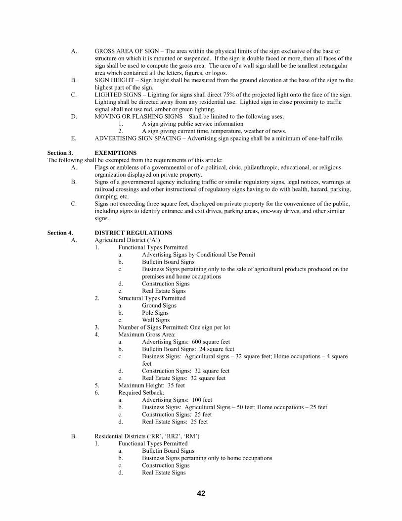
42
A. GROSS AREA OF SIGN – The area within the physical limits of the sign exclusive of the base or structure on which it is mounted or suspended. If the sign is double faced or more, then all faces of the sign shall be used to compute the gross area. The area of a wall sign shall be the smallest rectangular area which contained all the letters, figures, or logos.
B. SIGN HEIGHT – Sign height shall be measured from the ground elevation at the base of the sign to the highest part of the sign.
C. LIGHTED SIGNS – Lighting for signs shall direct 75% of the projected light onto the face of the sign. Lighting shall be directed away from any residential use. Lighted sign in close proximity to traffic signal shall not use red, amber or green lighting.
D. MOVING OR FLASHING SIGNS – Shall be limited to the following uses; 1. A sign giving public service information 2. A sign giving current time, temperature, weather of news. E. ADVERTISING SIGN SPACING – Advertising sign spacing shall be a minimum of one-half mile.
Section 3. EXEMPTIONS The following shall be exempted from the requirements of this article: A. Flags or emblems of a governmental or of a political, civic, philanthropic, educational, or religious
organization displayed on private property. B. Signs of a governmental agency including traffic or similar regulatory signs, legal notices, warnings at
railroad crossings and other instructional of regulatory signs having to do with health, hazard, parking, dumping, etc.
C. Signs not exceeding three square feet, displayed on private property for the convenience of the public, including signs to identify entrance and exit drives, parking areas, one-way drives, and other similar signs.
Section 4. DISTRICT REGULATIONS
A. Agricultural District (‘A’) 1. Functional Types Permitted
a. Advertising Signs by Conditional Use Permit b. Bulletin Board Signs c. Business Signs pertaining only to the sale of agricultural products produced on the
premises and home occupations d. Construction Signs
e. Real Estate Signs 2. Structural Types Permitted a. Ground Signs b. Pole Signs c. Wall Signs 3. Number of Signs Permitted: One sign per lot 4. Maximum Gross Area:
a. Advertising Signs: 600 square feet b. Bulletin Board Signs: 24 square feet c. Business Signs: Agricultural signs – 32 square feet; Home occupations – 4 square
feet d. Construction Signs: 32 square feet
e. Real Estate Signs: 32 square feet 5. Maximum Height: 35 feet 6. Required Setback:
a. Advertising Signs: 100 feet b. Business Signs: Agricultural Signs – 50 feet; Home occupations – 25 feet c. Construction Signs: 25 feet
d. Real Estate Signs: 25 feet B. Residential Districts (‘RR’, ‘RR2’, ‘RM’) 1. Functional Types Permitted a. Bulletin Board Signs
b. Business Signs pertaining only to home occupations c. Construction Signs
d. Real Estate Signs

43
2. Structural Types Permitted a. Ground Signs b. Wall Signs 3. Number of Signs Permitted: One sign per lot 4. Maximum Gross Area: a. Bulletin Board Signs: 24 square feet
b. Business Signs: Home occupations – 4 square feet c. Construction Signs: 24 square feet
d. Real Estate Signs: 4 square feet 5. Maximum Height: 12 feet 6. Required Setback: One-half the required front yard setback of the district C. Commercial Districts (‘TS’, ‘NC’, ‘HD’, ‘GB’)
1. Functional Types Permitted a. Advertising Signs by Conditional Use Permit b. Bulletin Board Signs c. Business Signs e. Construction Signs
f. Real Estate Signs 2. Structural Types Permitted: a. Canopy or Marquee Signs b. Ground Signs c. Pole Signs d. Roof Signs e. Wall Signs 3. Number of Signs Permitted:
a. Canopy or Marquee Signs: No limits b. Ground Signs: Two per lot c. Pole Signs: Two per lot d. Roof Signs: One per lot e. Wall Signs: No limits
4. Maximum Gross Area: a. Advertising Signs: 600 square feet b. Bulletin Board Signs: 24 square feet c. Business Signs: 100 square feet d. Construction Signs: 24 square feet
e. Real Estate Signs: 6 square feet 5. Maximum Height: 35 feet 6. Required Setback:
a. Advertising Signs: 100 feet b. Bulletin Board Signs: One-half the required setback of the district c. Business Signs: One-half the required front yard setback of the district d. Construction Signs: 25 feet
e. Real Estate Signs: 25 feet D. Industrial Districts (‘LI’, ‘HI’)
1. Functional Types Permits a. Bulletin Board Signs b. Business Signs c. Construction Signs
d. Real Estate Signs 2. Structural Types Permitted: a. Canopy or Marquee Signs b. Ground Signs c. Pole Signs e. Wall Signs 3. Number of Signs Permitted:
a. Canopy or Marquee Signs: No limits b. Ground Signs: Two per lot
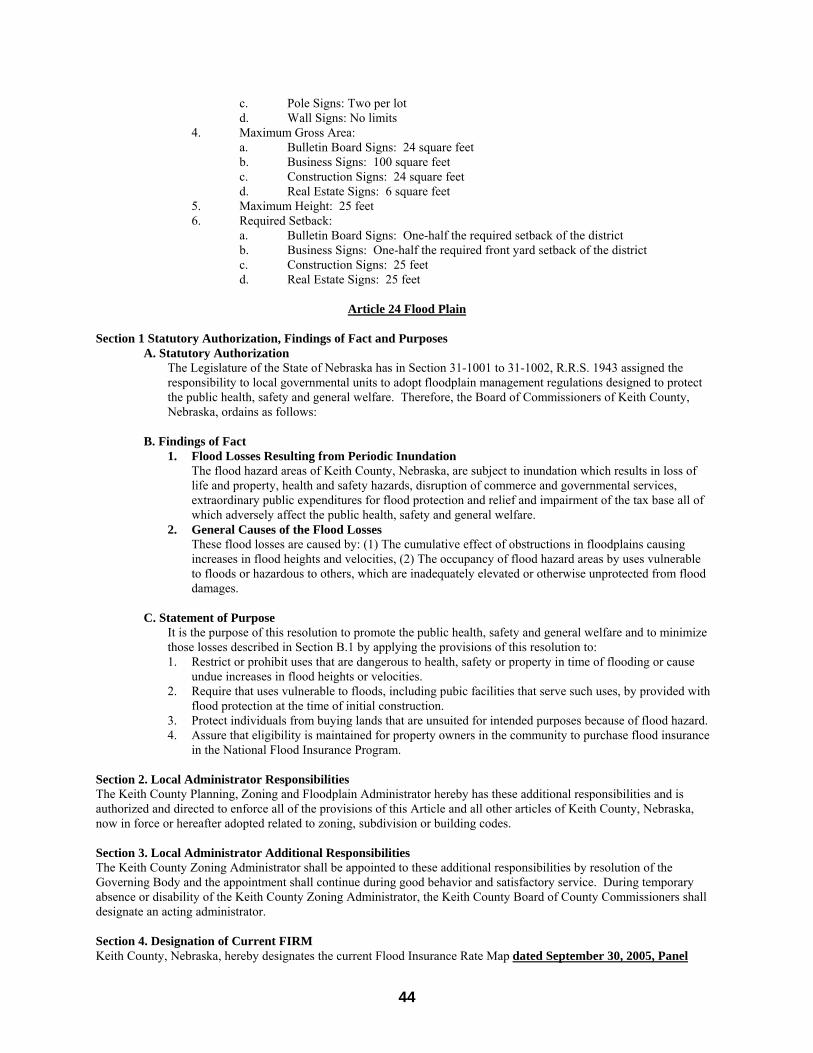
44
c. Pole Signs: Two per lot d. Wall Signs: No limits
4. Maximum Gross Area: a. Bulletin Board Signs: 24 square feet b. Business Signs: 100 square feet c. Construction Signs: 24 square feet
d. Real Estate Signs: 6 square feet 5. Maximum Height: 25 feet 6. Required Setback:
a. Bulletin Board Signs: One-half the required setback of the district b. Business Signs: One-half the required front yard setback of the district c. Construction Signs: 25 feet
d. Real Estate Signs: 25 feet
Article 24 Flood Plain Section 1 Statutory Authorization, Findings of Fact and Purposes A. Statutory Authorization
The Legislature of the State of Nebraska has in Section 31-1001 to 31-1002, R.R.S. 1943 assigned the responsibility to local governmental units to adopt floodplain management regulations designed to protect the public health, safety and general welfare. Therefore, the Board of Commissioners of Keith County, Nebraska, ordains as follows:
B. Findings of Fact
1. Flood Losses Resulting from Periodic Inundation The flood hazard areas of Keith County, Nebraska, are subject to inundation which results in loss of
life and property, health and safety hazards, disruption of commerce and governmental services, extraordinary public expenditures for flood protection and relief and impairment of the tax base all of which adversely affect the public health, safety and general welfare.
2. General Causes of the Flood Losses These flood losses are caused by: (1) The cumulative effect of obstructions in floodplains causing
increases in flood heights and velocities, (2) The occupancy of flood hazard areas by uses vulnerable to floods or hazardous to others, which are inadequately elevated or otherwise unprotected from flood damages.
C. Statement of Purpose
It is the purpose of this resolution to promote the public health, safety and general welfare and to minimize those losses described in Section B.1 by applying the provisions of this resolution to: 1. Restrict or prohibit uses that are dangerous to health, safety or property in time of flooding or cause
undue increases in flood heights or velocities. 2. Require that uses vulnerable to floods, including pubic facilities that serve such uses, by provided with
flood protection at the time of initial construction. 3. Protect individuals from buying lands that are unsuited for intended purposes because of flood hazard. 4. Assure that eligibility is maintained for property owners in the community to purchase flood insurance
in the National Flood Insurance Program.
Section 2. Local Administrator Responsibilities The Keith County Planning, Zoning and Floodplain Administrator hereby has these additional responsibilities and is authorized and directed to enforce all of the provisions of this Article and all other articles of Keith County, Nebraska, now in force or hereafter adopted related to zoning, subdivision or building codes. Section 3. Local Administrator Additional Responsibilities The Keith County Zoning Administrator shall be appointed to these additional responsibilities by resolution of the Governing Body and the appointment shall continue during good behavior and satisfactory service. During temporary absence or disability of the Keith County Zoning Administrator, the Keith County Board of County Commissioners shall designate an acting administrator. Section 4. Designation of Current FIRM Keith County, Nebraska, hereby designates the current Flood Insurance Rate Map dated September 30, 2005, Panel

45
Numbers 31101C0025C thru 31101C0700C and any revisions thereto, as the official map to be used in determining those areas of special flood hazard, Section 5. Permits Required Permits Required: No person, firm or corporation shall initiate any floodplain development or substantial improvement or cause the same to be done without first obtaining a separate permit for development as defined in this Article.
A. Within special flood hazard areas on the official map, separate floodplain development permits are required for all new construction, substantial improvements and other developments, including the placement of manufactured homes.
B. Application: To obtain a floodplain development permit, the applicant shall first file an application therefore in writing on a form furnished for that purpose. Every application shall:
1. Identify and describe the development to be covered by the floodplain development permit for which application is made.
2. Described the location of the development by lot, block, tract and street address, or similar description that will readily identify and definitely locate the proposed building or development.
3. Indicate the use or occupancy for which the proposed development is intended. 4. Be accompanied by plans and specifications for proposed construction. 5. Be signed by the permittee or their authorized agent who may be required to submit evidence
to indicate such authority. 6. Within designated floodplain areas, be accompanied by elevations of the lowest floor,
including basement, or in the case of flood proofed non-residential structures, the elevation to which it shall be floodproofed. The Keith County Planning, Zoning and Floodplain Administrator shall maintain documentation or certification of such elevations.
7. Provide other information as may be required by the Keith County Planning, Zoning and Floodplain Administrator. (i.e., require a statement from the applicant that they are aware that elevating or floodproofing structures above the minimum levels will result in premium reduction, especially in the case of non-residential floodproofing when a minus one foot (-1”0 penalty is assessed at the time of rating the structure for the policy premium.)
Section 6. Development Permit Application Review The Keith County Planning, Zoning and Floodplain Administrator shall review all development permit applications to determine if the site of the proposed development is reasonably safe from flooding and that all necessary permits have been received as required by Federal or State Law. Section 7. Application Review The Keith County Planning, Zoning and Floodplain Administrator, in reviewing all applications for new construction, substantial improvements, prefabricated buildings, placement of manufacture homes and other development(s) (as defined in Section 21 of this Article) shall: A. Obtain, review and reasonably utilize, if available, any regulatory flood elevation data and floodway data
available from Federal, State or other sources, until such other data is provided by the Federal Insurance Administration in a Flood Insurance Study; and require within special flood hazard areas on the official map that the following performance standards be met: 1. Until a floodway has been designated - No development or substantial improvement may be permitted
within the identified floodplain unless the applicant has demonstrated that the proposed development or substantial improvement, when combined with all other existing and reasonably anticipated developments or substantial improvements, will not increase the water surface elevation of the 100 year flood more that one foot at any location.
2. Residential Construction - New construction or substantial improvement of any residential structure shall have the lowest floor, including basement, elevated at least on foot above the base flood elevation.
3. Non-residential Construction - New construction or substantial improvement of any commercial, industrial or other non-residential structure shall either have the lowest floor, including basement, elevated at least one foot above the base flood elevation or, together with attendant utility and sanitary facilities, be flood proofed so that below such a level the structure is watertight with walls substantially impermeable to the passage of water and with structural components having the capability of resisting hydrostatic and hydrodynamic loads and effects of buoyancy. A registered professional engineer or architect shall certify that the standards of this subsection are satisfied. Such certification shall be provided to the local administrator.
4. Required for all new construction and substantial improvements -That fully enclosed areas below the lowest floor that are usable solely for parking of vehicles, building access or storage in an area other than a
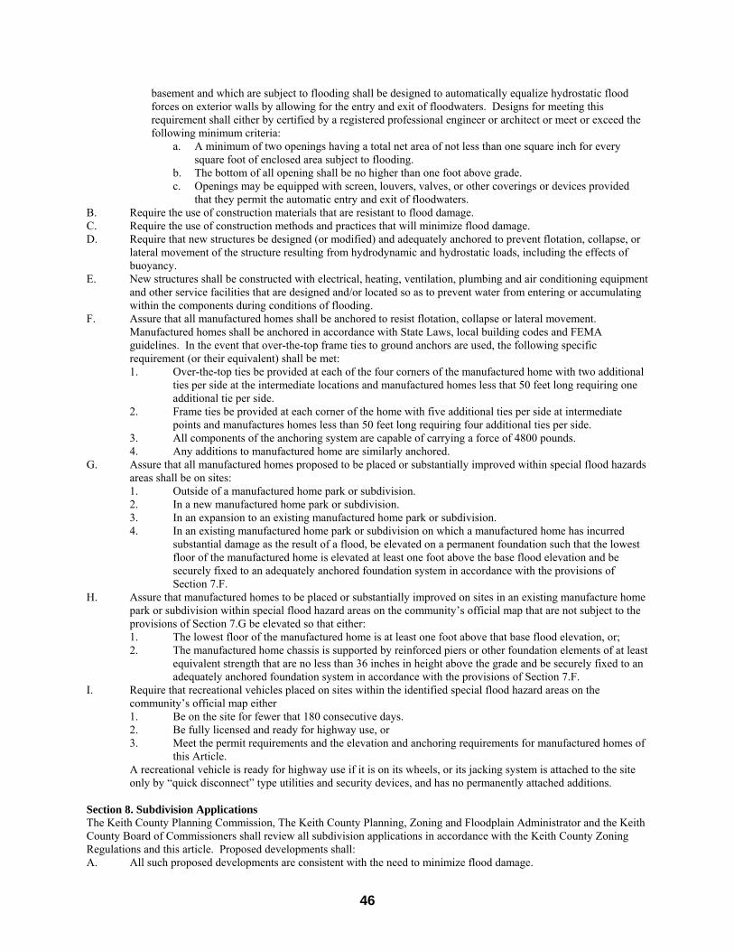
46
basement and which are subject to flooding shall be designed to automatically equalize hydrostatic flood forces on exterior walls by allowing for the entry and exit of floodwaters. Designs for meeting this requirement shall either by certified by a registered professional engineer or architect or meet or exceed the following minimum criteria:
a. A minimum of two openings having a total net area of not less than one square inch for every square foot of enclosed area subject to flooding.
b. The bottom of all opening shall be no higher than one foot above grade. c. Openings may be equipped with screen, louvers, valves, or other coverings or devices provided
that they permit the automatic entry and exit of floodwaters. B. Require the use of construction materials that are resistant to flood damage. C. Require the use of construction methods and practices that will minimize flood damage. D. Require that new structures be designed (or modified) and adequately anchored to prevent flotation, collapse, or
lateral movement of the structure resulting from hydrodynamic and hydrostatic loads, including the effects of buoyancy.
E. New structures shall be constructed with electrical, heating, ventilation, plumbing and air conditioning equipment and other service facilities that are designed and/or located so as to prevent water from entering or accumulating within the components during conditions of flooding.
F. Assure that all manufactured homes shall be anchored to resist flotation, collapse or lateral movement. Manufactured homes shall be anchored in accordance with State Laws, local building codes and FEMA guidelines. In the event that over-the-top frame ties to ground anchors are used, the following specific requirement (or their equivalent) shall be met: 1. Over-the-top ties be provided at each of the four corners of the manufactured home with two additional
ties per side at the intermediate locations and manufactured homes less that 50 feet long requiring one additional tie per side.
2. Frame ties be provided at each corner of the home with five additional ties per side at intermediate points and manufactures homes less than 50 feet long requiring four additional ties per side.
3. All components of the anchoring system are capable of carrying a force of 4800 pounds. 4. Any additions to manufactured home are similarly anchored.
G. Assure that all manufactured homes proposed to be placed or substantially improved within special flood hazards areas shall be on sites: 1. Outside of a manufactured home park or subdivision. 2. In a new manufactured home park or subdivision. 3. In an expansion to an existing manufactured home park or subdivision. 4. In an existing manufactured home park or subdivision on which a manufactured home has incurred
substantial damage as the result of a flood, be elevated on a permanent foundation such that the lowest floor of the manufactured home is elevated at least one foot above the base flood elevation and be securely fixed to an adequately anchored foundation system in accordance with the provisions of Section 7.F.
H. Assure that manufactured homes to be placed or substantially improved on sites in an existing manufacture home park or subdivision within special flood hazard areas on the community’s official map that are not subject to the provisions of Section 7.G be elevated so that either: 1. The lowest floor of the manufactured home is at least one foot above that base flood elevation, or; 2. The manufactured home chassis is supported by reinforced piers or other foundation elements of at least
equivalent strength that are no less than 36 inches in height above the grade and be securely fixed to an adequately anchored foundation system in accordance with the provisions of Section 7.F.
I. Require that recreational vehicles placed on sites within the identified special flood hazard areas on the community’s official map either 1. Be on the site for fewer that 180 consecutive days. 2. Be fully licensed and ready for highway use, or 3. Meet the permit requirements and the elevation and anchoring requirements for manufactured homes of
this Article. A recreational vehicle is ready for highway use if it is on its wheels, or its jacking system is attached to the site only by “quick disconnect” type utilities and security devices, and has no permanently attached additions.
Section 8. Subdivision Applications The Keith County Planning Commission, The Keith County Planning, Zoning and Floodplain Administrator and the Keith County Board of Commissioners shall review all subdivision applications in accordance with the Keith County Zoning Regulations and this article. Proposed developments shall: A. All such proposed developments are consistent with the need to minimize flood damage.
47
B. Subdivision proposals and other proposed new developments (including proposals for manufactured home parks and subdivisions), greater than five (5) acres, or 50 lots, whichever is less, include within such proposals regulatory flood elevation data in special flood hazard areas.
C. Adequate drainage is provided so as to reduce exposure to flood hazards. D. All public utilities and facilities are located so as to minimize or eliminate flood damage. Section 9. Water and Sewage Systems New and replacement water and sewage systems shall be constructed to eliminate or minimize infiltration by, or discharge into floodwaters. Moreover, on-site waste disposal systems will be designed to avoid impairment or contamination during flooding. Section 10. Storage of Material and Equipment The storage or processing of materials hat are in time of flooding buoyant, flammable, explosive or could be injurious to human, animal or plant life is prohibited. Storage of other material or equipment may be allowed if not subject to major damage by floods and firmly anchored to prevent flotation or if readily removable from the area within the time available after flood warning. Section 11. Flood-Carrying Capacity Within Any Watercourse The Keith County Board of Commissioners will ensure that the flood-carrying capacity within the altered or relocated portion of any watercourse is maintained. Keith County will notify, in riverine situations, adjacent communities and the State Coordinating Office (Nebraska Department of Natural Resources) prior to any alteration or relocation of a watercourse, and submit copies of such notification to the Federal Emergency Management Agency. Section 12. Variance Procedures
1. The Keith County Board of Adjustments as established by the Keith County Board of Commissioners shall hear and decide appeals and requests for variances from the requirements of this article.
2. The Keith County Board of Adjustments shall hear and decide appeals when it is alleged that there is an error in any requirement, decision, or determination made by the Keith County Planning, Zoning and Floodplain Administrator, in the enforcement or administration of this Article.
3. Any person aggrieved by the decision of the Keith County Board of Adjustments or any taxpayer may appeal such decision to the District Court as provided in Section 23-168, R.R.S. 1943.
4. The Keith County Board of Adjustments shall consider all technical evaluations, relevant factors, standards specified in other section of this article, and;
A. The danger that materials may be swept onto other lands to the injury of others; B. The danger to life and property due to flooding or erosion damage; C. The susceptibility of the proposed facility and its contents to flood damage and the effect of
such damage on the individual owner; D. The importance of the services provided by the proposed facility to the community; E. The necessity to the facility of a waterfront location, where applicable; F. The availability of alternative locations, not subject to flooding or erosion damage, for the
proposed use; G. The compatibility of the proposed use with existing and anticipated development; H. The relationship of the proposed use to the Comprehensive Plan and floodplain management
programs for that area; I. The safety of access to the property in times of flood for ordinary and emergency vehicles; J. The expected heights, velocity, duration, rate of rise and sediment transport of the flood
waters and the effects of wave action, if applicable, expected at the site; and K. The costs of providing governmental services during and after flood conditions including
maintenance and repair of public utilities and facilities such as sewer, gas, electrical, and water systems, and streets and bridges.
Section 13. Conditions for Variances
1. Generally, variances may be issued for new construction and substantial improvements to be erected on a lot o one-half acre or less in size contiguous to and surrounded by lots with existing structures constructed below the base flood level, providing items 2-5 below have been fully considered. As the lot size increased beyond the on-half acre, the technical justification required for issuing the variance increases.
2. Variances may be issued for the repair or rehabilitation of historic structure upon a determination that the proposed repair or rehabilitation will not preclude the structure’s necessary to preserve the historic character and design of the structure
48
3. Variances shall only be issued upon a determination that the variance is the minimum necessary considering the flood hazard, to afford relief.
4. Variances shall only be issued upon: (i) a showing of good and sufficient cause, (ii) a determination that failure to grant the variance would result in exceptional hardship to the
applicant, and, (iii) a determination that the granting of a variance will not result in increased flood heights,
additional threats to public safety, extraordinary public expense, create nuisances, cause fraud on or victimization of the public, or conflict with existing local laws or articles.
5. The applicant shall be given a written notice over the signature of a community official that: i. the issuance of a variance to construct a structure below base flood level will result in
increased premium rates for flood insurance up to amounts as high as $25.00 for $100.00 of insurance coverage, and,
ii. such construction below the base flood level increases the risks to life and property. Such notification shall be maintained with the record of all variance actions as required by this article.
Section 14 Nonconforming Use
1. A structure or the use of a structure or premises which was lawful before the passage or amendment of the article, but which is not in conformity with the provisions of this article may be continued subject to the following conditions:
A. If such use is discontinued for 12 consecutive months, any future use of the building premises shall conform to this article.
B. Uses or adjuncts thereof that are or become nuisances shall not be entitled to continue as nonconforming uses.
2. If any nonconforming use or structure is destroyed by any means, including flood, it shall not be reconstructed if the cost is more than 50 percent of the market value of the structure before the damage occurred except that if it s reconstructed in conformity with the provision of this article. This limitation does not include the cost of any alteration to comply with existing state or local health, sanitary, building or safety codes or regulations or the cost of any alteration of a structure listed on the National Register of Historic Places or a State Inventory of Historic Places.
Section 15. Penalties for Violation Violation of the provision of this article or failure to comply with any of its requirement (including violations of conditions and safeguards established in connection with grants of variances or special exceptions) shall constitute a misdemeanor. Any person who violates this article or fails to comply with any of its requirements shall upon conviction thereof by fined not more than $500.00, and in addition, shall pay all costs and expenses involved in the case. Each day of such violation shall be considered a separate offense. Nothing herein contained shall prevent the Keith County Planning, Zoning and Floodplain Administration Department, the Keith County Board of Commissioners and the Keith County Attorney from taking such other lawful action as is necessary to prevent or remedy any violation. Section 16. Abrogation and Greater Restrictions It is not intended by this article to repeal, abrogate or impair any existent easements, covenants, or deed restrictions. However, where this article imposes greater restrictions, the provision of this article shall prevail. All other articles inconsistent with this article are hereby repealed to the extent of the inconsistency only. Section 17. Interpretation In their interpretation and application, the provisions of this article shall be held to be minimum requirements and shall be liberally construed in favor of the governing body and shall not be deemed a limitation or repeal, of any other powers granted by state statutes. Section 18. Warning and Disclaimer of Liability The degree of flood protection required by this article is considered reasonable for regulatory purposes and is based on engineering and scientific methods of study. Larger floods may occur on rare occasions or the flood height may be increased by man-made or natural causes, such as ice jams and bridge opening restricted by debris. This article does not imply that areas outside floodplain district boundaries or land uses permitted within such districts will be free from flooding or flood damage. This article shall not create liability on the part of Keith County, Nebraska, or any officer or employee thereof for any flood
49
damages that may result from reliance on this article or any administrative decision lawfully made thereunder. Section 19. Severability If any section, clause, provision or portion of this article is adjudges unconstitutional or invalid by a court of competent jurisdiction, the remainder of this article shall not be affected thereby. Section 20. Appeal Where the Keith County Planning, Zoning and Floodplain Administrator deny a request for a permit to develop or a variance, the applicant may apply for such permit or variance directly to the Keith County Board of Adjustments. Section 21. Conflicting Articles This article shall take precedence over conflicting articles or parts of articles. The Keith County Board of Commissioners may, from time to time, amend this article to reflect any and all changes in the National Flood Disaster Protection Act of 1973. The regulations of this article are in compliance with the National Flood Insurance Program Regulations as published in Title 44 of the Code of Federal Regulations and the 1983 Nebraska Floodplain Management Act. Section 21. Definitions Unless specifically defined below, words or phrases used in this Article shall be interpreted so as to give them the same meaning as they have in common usage and so as to give this Article its most reasonable application. These definitions apply only to this Article. For example, the Floodplain definitions refer to manufactured homes, generally, the Keith County zoning and subdivision regulations refer to mobile homes. Base Flood means the flood having one percent chance of being equaled or exceeded in ay given year. Basement means nay area of the building having its floor subgrade (below ground level) on all sides. Development means nay man-made change to improved or unimproved real estate, including but not limited to buildings or other structures, mining, dredging filling, grading, paving, excavation or drilling operations or storage of equipment or materials. Existing Manufactured Home Park or Subdivision means a manufactured home park or subdivision for which the construction of facilities for servicing the lots on which the manufactured homes are to be affixed (including, at a minimum, the installation of utilities, the construction of streets, and either final site grading or the pouring of concrete pads) is complete before the effective date of the floodplain management regulations adopted by a community. Expansion of Existing Manufactured Home Park or Subdivision means the preparation of additional sites by the construction of facilities for servicing the lots on which the manufactured homes are to be affixed (including the installation of utilities, the construction of streets, and either final site grading or the pouring of concrete pads). Flood means a general and temporary condition of partial or complete inundation of normally dry land areas from: (1) the overflow of inland or tidal waters. (2) The unusual and rapid accumulation of runoff of surface waters from any source. Flood Insurance Rate Map (FIRM) means an official map of a community, on which the Administrator has delineated both the special flood hazard areas and the risk premium applicable to the community. Floodplain means any land area susceptible to being inundated by water from a source (see definition of flooding). Flood proofing means any combination of structural and non-structural additions, changes or adjustments to structure that reduce or eliminate flood damage to real estate or improved real property, water and sanitary facilities, structures and their contents. Floodway means the channel of the river or other watercourse and the adjacent land areas that must be reserved in order to discharge the base flood without cumulatively increasing the water surface elevation more than a designated height. Historic Structure means any structure that is (a) Listed individually in the National Register of Historic Places (a listing maintained by the Department of Interior) or preliminary determined by the Secretary of the Interior as meeting the requirements for individual listing on the National Register; (b) Certified or preliminarily determined by the Secretary of the Interior as contributing to the historical significance of a registered historic district or a district preliminarily determined by the Secretary to qualify as a registered historic district; (c) Individually listed on a state inventory of historic places in states with historic preservation programs which have been approved by the Secretary of the Interior; (d) Individually listed on a local inventory of historic places in communities with historic preservation programs that have been certified either: (1) By an approved state program as determined by the Secretary of the Interior or (2) Directly by the Secretary of the Interior in states without approved programs. Lowest Floor means the lowest floor of the lowest enclosed area (including basement). An unfinished or flood-resistant enclosure, usable solely for parking of vehicles, building access or storage, in an area other than a basement area, is not considered a building’s lowest floor, provided that such enclosure is not built so as to render the structure in violation of the applicable non-elevation design requirements of this Article. Manufactured Home means a structure, transportable in one or more sections, which is built on a permanent chassis and is designed for use with or without a permanent foundation when attached to the required utilities. The term “manufacture home”
50
does not include a recreational vehicle. Manufactured Home Park or Subdivision means a parcel (or contiguous parcels) of land divided into two or more manufactured home lots for rent or sale. New Construction for floodplain management purposes, “new construction” means structures for which the “start of construction commenced on or after the effective date of the floodplain management regulations adopted by a community and includes any subsequent improvements to such structures. New Manufactured Home Park of Subdivision means a manufactured home park or subdivision for which the construction of facilities for servicing the lots on which the manufactured homes are to be affixed (including at a minimum the installation of utilities, the construction of streets, and either the final site grading or the pouring of concrete pads) is completed on or after the effective date of floodplain management regulations adopted by a community. 100 Year Flood means the condition of flooding having a one percent chance of annual occurrence. Principally Above Ground means that at least 51 percent of the actual cash value of the structure is above ground. Recreational Vehicle means a vehicle which is (i) built on a single chassis; (ii) 400 square feet or less when measured at the largest horizontal projection; (iii) designed to be self-propelled or permanently towable by a light duty truck; and (iv) designed primarily not for use as a permanent dwelling but as temporary living quarters for recreational, camping, travel, or seasonal use. Regulatory Flood Elevation means the water surface elevation of the 100-year flood. Special Flood Hazard Area is the land in the floodplain within a community subject to one percent or greater chance of flooding in any given year. Start of Construction (for other than new construction or substantial improvements under the coastal Barrier Resources Act (Pub.L.97-348)) includes substantial improvement, and means the date the building permit was issued, provided the actual start of construction, repair, reconstruction, rehabilitation, addition, placement, or other improvement was within 180 days of the permit date. The actual start means the first placement of permanent construction of a structure on a site, such as the pouring of slab or footings, the installation of piles, the construction of columns, or any work beyond the stage of excavation; or the placement of a manufactured home on a foundation. Permanent construction does not include land preparation, walkways; nor does it include excavation for a basement, footing, piers, or foundations or the erection or temporary forms; nor does it include the installation on the property of accessory buildings, such as garages or sheds not occupied as dwelling units or not part of the main structure. For a substantial improvement, the actual start of construction means the first alteration of any wall, ceiling, floor, or other structural part of a building, whether or not the alteration affects the external dimensions of the building. Structure means a walled and roofed building that is principally above ground, as well as a manufactured home, and a gas or liquid storage tank that is principally above ground. Substantial Damage means damage of any origin sustained by a structure whereby the cost of restoring the structure to its before-damaged condition would equal or exceed 50 percent of the market value of the structure before the damage occurred. Substantial Improvement means any reconstruction, rehabilitation, addition, or other improvement of a structure, the cost of which equals or exceeds 50 percent of the market value of the structure before “start of construction” of the improvement. This includes structures that have incurred “substantial damage” regardless of the actual repair work performed. The term does not, however, include either (1) any project for improvement of a structure to correct existing violations of state or local health, sanitary or safety code specifications which have been identified by the local code enforcement official and which are the minimum necessary to assure safe living conditions, or (2) any alteration of a “historic structure” provided that the alteration will no preclude the structure’s continued designation as a “historic structure”. Variance means a grant of relief to a person from the terms of a floodplain management article. Violation means the failure of a structure or other development to be fully compliant with the community’s floodplain management regulations.
Article 25 Administration, Permits, Enforcement Section 1 Zoning Administrator A. Appointment of administrator. The County Commissioners shall designate a zoning administrator who will be
charged with the authority and responsibility of administering, establishing rules of procedures for and enforcing the terms of these regulations.
B. Duties and powers of administrator. The zoning administrator shall receive all applications for permits to construct, alter, repair, occupy and use or change the use of land, buildings and structures as required by these regulations; collect a fee for administration where required by these regulations; and issue such permits to construct, alter, repair, occupy and use or change the use of land, buildings and structures when the provisions of these regulations have been complied with; and shall deny any permit which would allow violations of the terms of these regulations. The administrator shall issue all necessary notices or orders to cease illegal use or construction of land, buildings or structures as required to insure compliance with the intent and terms for amendments to the zoning map and transmit such applications to the Planning Commission as required by these regulations.
51
Section 2 Permits and Certifications A. Permit required. It shall be unlawful to construct, enlarge, alter, remove or demolish structures, signs or
buildings or change the occupancy of the land or buildings from one use to another without first filing an application with the zoning administrator in writing and obtaining the required permit.
B. Form of application. The application for a permit shall be submitted in such form as the zoning administrator may prescribe.
C. Fees for permits. Fees paid for permits shall be adopted by resolution of County Commissioners. D. Certificate of use and occupancy. Provisions for the issuance of a certificate of use and occupancy as contained
in the building code shall apply to the enforcement of these regulations. E. Expiration of permit. Construction shall start within six months of the date issuance of the permit, and be
completed with one year of the date of issuance of the permit. Permit shall be extended upon request to the zoning administrator prior to the expiration date.
F. Permits are not required for agricultural buildings, fencing, stock wells, or dirt work in Agriculture zone. Section 3 Enforcement A. Notice of violation. The zoning administrator shall serve a “notice of violation” or order on the person
responsible for the erection, construction, alteration, extension, repair use or occupancy of a building, structure, or land in violation of these regulations, or in violations of a permit or certificate issued under the provisions of these regulations, and the order shall direct the discontinuance of the illegal action or condition and the abatement of the violation.
B. Prosecution of violation. If the notice of violation is not complied with promptly, the zoning administrator shall request the County Attorney to institute the appropriate proceeding at law or in equity to restrain, correct or abate such violation or to require the removal or termination of the unlawful use of the building, structure or land in violation of the provisions of these regulations, or of the order or direction made pursuant thereto.
C. Any person who shall violate a provision of these regulations, or shall fail to comply with the order or direction made pursuant thereto, shall be guilty of a class III (3) misdemeanor, punishable by a fine of not more than five hundred dollars, or by imprisonment for not more then three months or both. Each day such violation or failure to comply occurs or is continued, after notice of violation has been given to the offender, may be considered a separate offense.
Section 4 Liability for Damages This resolution shall not be construed to hold the County responsible for any damages to persons or property by reason of the inspection or re-inspection authorized herein or failure to inspect or re-inspect of by reason of issuing a building permit as herein provided. Section 5 Minor Variations When in the public interest, the zoning administrator, without publishing posting or mailing notice and without public hearing, may consider and render decisions on minor variances involving slight modification to the provisions to the resolution, but being limited to the following: A. Reduction of lot area and/or minimum floor area by not more than the following amount: 1) Maximum lot area reduction - ten percent 2) Maximum floor area reduction - five percent 3) Reduction of yards and open areas by permitting portions of a building to extend into and occupy not more
than ten percent of the distance of the required yard. B. Waiver of yard setbacks when two lots area used for one primary building and when such building will extend
into both lots. All other front yard, side yard and rear yard setbacks as required in the zoning district shall be maintained. In granting a minor variance, the zoning administrator shall make a finding that the granting of this variance conforms to the intent of Article 26 Section 5, which sets forth the criteria for the granting of variances.
Section 6 Other Uses Permitted The Zoning Administrator is authorized to allow other uses within all the zoning districts and overlay districts under the following criteria: A. A request has been made in writing describing the proposed land use and in what district it is proposed. B. The Zoning Administrator finds the following and justifies the decision in writing:
1) The proposed use is similar to the permitted uses allowed within the district. 2) The proposed use will not generate more traffic than the surrounding transportation system will handle. 3) The proposed use will not adversely impact the surrounding land use.
52
Any use authorized by the Zoning Administrator shall be reported to the Keith County Planning Commission and the Keith County Board of County Commissioners. During the next rewrite of the Zoning Regulations or any portion of the Zoning Regulations that authorized use shall be incorporated into the Regulations. A request for an additional use is not automatic, but must be clearly authorized by findings of fact to warrant the decision.
Article 26 Board of Adjustment Section 1 Purpose - Membership A. The Board of Adjustment shall consist of five members, each to be appointed for a term of three years and be
removable for cause by the appointing authority upon written charges and after public hearing. Vacancies shall be filled for the unexpired term of any member whose term becomes vacant. One member only of the Board of Adjustment shall be appointed by the County Commissioners from the membership on the Planning Commission and the loss of membership on the Planning Commission by such member shall also result in his/hers immediate loss of membership on the Board of Adjustment and the appointment of another Planning Commissioner to the Board of Adjustment.
B. The Board of Adjustment shall adopt rules in accordance with the provisions of any resolution adopted pursuant to this act. Meetings of the board shall be held at the call of the chairman and at such other times as the board may determine. Such chairman, or in his absence the acting chairman, may administer oaths and compel the attendance of witnesses. All meetings of the board shall be open to the public. The board shall keep minutes of it’s proceedings, showing the vote of each member upon each question or if absent or failing to vote, indicating such fact and shall keep records of its examinations and other official actions, all of which shall be immediately filed with the County Clerk and shall be a public record.
Section 2 Meetings Meetings of the board shall be held at the call of the chairman at such other times as the board may determine. Such chairman, or in his/her absence the acting chairman, may administer oaths and compel the attendance of witnessed. All meetings of the board shall be open to the public. The board shall keep minutes of its proceedings, showing the vote, indicating such fact and shall keep records of its examinations and other official actions, all of which shall immediately be filed in the office of the board and shall be a public record. Section 3 Appeals Appeals to the Board of Adjustment may be taken by any person aggrieved or by any officer, department, board or bureau of the County affected by any decision of the zoning administrator. Such appeal shall be made within ten days from the date of decision by any county officer or department. The appeal filed in writing shall define the appeals be requested and the grounds therefore. The officer from whom the appeal is taken shall forthwith transmit to the board all papers constituting the records upon which the action appealed from was taken. An appeal stays all proceedings in furtherance of the action appealed from, unless the officer from whom the appeal is taken certifies to the Board of Adjustment, after the notice of appeal shall have been filed with him/her, that by reason of facts stated in the certificate and stay would, in his/her opinion, cause imminent peril to the life or property. In such case, proceedings shall not be stayed otherwise than by a restraining order which may be granted by the Board of Adjustment or by a court of record on application or notice to the officer from whom the appeal is taken and on due cause shown. Section 4 Hearing The chairman of the Board of Adjustments shall set a hearing within thirty days of receipt of the appeal by the clerk of the board. The time, date, place of the hearing and description of the request shall be published in the local newspaper of general distribution ten days prior to actual hearing. The clerk of the board shall also notify the interested parties in the case of the hearing date, time and place. Section 5 Authority The Board of Adjustment shall have the following powers: A. To hear and decide appeals where it is alleged there is error in any order, requirements, decision or
determination made by an administrative official or an agency based on or made in the enforcement of the zoning regulation or any regulation relating to the location or soundness of structures;
B. To hear and decide, in accordance with the provisions of any regulation, request for interpretation of any map or for decisions upon other special questions upon which the board is authorized by any such regulation to pass;
53
and C. Whereby reason of exceptional narrowness, shallowness, or shape of a specific piece of property at the time of
the enactment of the regulations, or by reason of exceptional topographic conditions or other extraordinary and exceptional situation or condition of such piece of property, the strict application of any enacted regulation under this act would result in peculiar and exceptional practical difficulties to, or exceptional and undue hardship upon the owner of such property, to authorize, upon appeal relating to the property, a variance from such strict application so as to relieve such difficulties or hardship, if such relief may be granted without substantial detriment to the public good and without substantially impairing the intent and purpose of zoning regulations, but no such variance shall be authorized unless the Board of Adjustment finds that:
1) The strict application of the resolution would produce undue hardship 2) Such hardship is not shared generally by other properties in the same zoning district and the same
vicinity 3) The authorization of such variance will not be of substantial detriment to adjacent property and the
character of the district will not be changed by the granting of the variance 4) The granting of such variance is based upon the reasons of demonstrable and exceptional hardship
as distinguished from variations for purpose of convenience, profit of caprice. No variance shall be authorized unless the board finds that the condition or situation of the property concerned or the intended use of the property is not of so general or recurring in nature as to make reasonably practicable the formulation of a general regulation to be adopted as an amendment to the resolution. In exercising the above mentioned powers, the board may, reverse or affirm, wholly or partly, or may modify the order, requirement, decision, or determination appealed from and may make such order, requirement, decision, or determination as shall be proper, and to that end shall have the power of the officer or agency from whom the appeal is taken, the concurring vote of four members of the board shall be necessary to reverse any order, requirement, decision or determination of any such administrative official, or to decide in under any such resolution or to effect any variation in such resolution.
Article 27 Amendments
Section 1 Initiation of Amendment An application for an amendment may be initiated in any one of the following ways: A. By the owner of the property for which the amendment would apply or an authorized agent for the owner; or B. By the Planning Commission; or C. By the County Commissioners who would instruct the Planning Commission to review an amendment. An amendment to either the text or to the zoning map is considered to be an amendment to this resolution. Section 2 Application A. All applications for amendments shall be submitted to the Planning Commission (or its authorized staff
representative) at least twenty days to a regular meeting of the Planning Commission. B. The application, when submitted, shall be accepted only when it includes all of the following information:
1) A certified survey boundary survey or adequate legal description of the property for which the application is made to adequately define the location of the site by dimensions.
2) Authorization from the property owner agreeing to the submittal of the application if the owner is not the applicant.
3) A vicinity map that defines access to the site and defines adjacent zoning and land use. In urban areas, this information shall be shown for a distance of six hundred feet from the site; in rural areas, this distance shall be extended to two thousand five hundred (2500) feet, (the Planning Commission may request a larger area of coverage if the proposed use may impact a much larger area).
C. An application fee as may be adopted by resolution of the County Commissioners shall be submitted to cover processing and hearing costs.
Section 3 Procedures A. Upon receipt of a complete application and filing fee, the Planning Commission or its authorized staff
representative shall set the request for public hearing by publishing a description of the request and the time, date and place for the hearing at least ten days prior to the scheduled hearing date. Adjacent property owners abutting or across the street or alley from the subject site shall be notified in writing of the proposed request and scheduled hearing time, date and place. If, in the opinion of the Planning Commission or its authorized agent, the proposed use could impact a much larger area, the notice area may be extended. Current tax records shall be used to determine ownership. Should the applicant request a delay of hearing more than twice (2) after due
54
notice to affected landowners and a publication in the official county newspaper, said applicant shall be required to pay a full fee for renewal of the Conditional Use by Special Permit or Zoning Map Amendment application.
B. The staff representative for the Planning Commission shall, prior to the hearing, accomplish the following: 1) Refer the request to other interested agencies and the county departments for comment.
2) Prepare a staff report outlining findings and recommendations that will assist the Planning Commission in making a decision in the matter.
3) Refer the report to the Planning Commission and the applicant at least three days prior to the scheduled hearing date.
C. The Planning Commission shall hear and review the matter and, within thirty-five days of the first hearing, do one of the following:
1) Recommend approval to the County Commissioners and reasons for approval. 2) Recommend denial to the County Commissioners and reasons for said denial.
3) Table the matter for a specified period of time with the consent of the applicant for further study and review. D. The Planning Commission recommendations shall be forwarded to the County Commissioners along with the
application file. Said recommendations shall be recorded in the Planning Commission meeting minutes or in some other written form for review by the County Commissioners.
E. The County Clerk shall set a hearing date before the County Commissioners and provide notification in the manner prescribed in Section 3-1.
F. The County Commissioners shall hear the review the matter and shall, within thirty-five (35) days of said hearing, do one of the following:
1) Approve the request. 2) Deny the request.
3) Table the matter for a specified period of time with the consent of the applicant for further study and review. G. The reasons for the County Commissioners action on the request shall be defined in the official minutes of the
County Commissioners meetings. Section 4 Similar Amendments A proposed rezoning request for a similar classification and/or area to one already reviewed by the County Commissioners shall not be reconsidered by the County Commissioners within twelve months of the date of such County Commissioners action. Submission by a different applicant or minor changes in boundaries shall not be adequate reason to circumvent this requirement. Section 5 Time Limitations on Amendments to the Zoning District Map At the time the Planning Commission and the County Commissioners consider an initial zoning request, a rezoning request and/or any amendments to the zoning district map, the applicant shall be advised that the land must be developed in accordance with the designated zoning classification within two (2) years after the date of granting same and that, in the event such development is not completed or substantially commenced within said two year period, the County may, at its sole and exclusive option, review said zoning classification and initiate proceedings to rezone the land to the classification said land held immediately prior thereto or to such other zoning classification as may be determined by the County Commissioners.
Article 28 Definitions As used in this resolution the following words shall be interpreted and defined in accordance with the provisions set forth in this section. Section 1 Rules and Construction of Language A. The particular controls the general. B. In case of any difference of meaning or implementation between the text of this ordinance and the captions for
each section, the text shall control. C. The word “shall” is always mandatory and not discretionary. The “may” is permissive. D. Words used in the present tense include the future tense, unless the context clearly indicates the contrary. E. Words used in the singular number include the plural, and words used in the plural number include the singular
unless the context clearly indicates the contrary. F. A “building” or “structure” includes any part thereof. A “building” or other “structure” includes all other
structures of every kind, regardless of similarity to buildings. G. The phrase “use for” includes “arranged for”, “designated for”, “intended for”, “maintained for” and “occupied
for”.
Section 2 Definitions

55
ABUTTING - Abutting shall mean adjacent or contiguous and shall include property separated by an alley. ACCESSORY BUILDINGS AND USES - An accessory building is a subordinate building or portion of the main building, the use of which is incidental to that main building or to the main use of the premises. An accessory use is one that is incidental to the main use of the premises. ACCESSORY USE – An accessory use is subordinate TO the PRIMARY use. An accessory use in one that is incidental to the PRIMARY use of the premises. AGGREGATE PROJECT - Shall mean projects that are developed and operated in a coordinated fashion but which have multiple entities owning one or more of the individual WES within the larger project. Associated infrastructure, power lines, transformers, and accessory buildings that service the WES may be owned by a separate entity but also part of the project. AGRICULTURE - Agriculture shall mean the use of land for the purpose of raising and harvesting crops, or for the raising, breeding, or management of livestock, poultry, fish, or honeybees; or for dairying, truck gardening, forestry, nurseries, or orchards; for non-commercial on-farm storage or processing of agricultural products; or for any other similar agricultural, horticultural, silvacultural, aquacultural. ALLEY - Alley shall mean a public or private way not designed for general travel or to allow through vehicular traffic, used as a secondary access to the rear or side of lots, which shall in no way be a street. ANIMAL FEEDING OPERATION (either AFO or CAFO) - Animal Feeding Operation (either AFO or CAFO) shall mean an area of more than the following numbers of animals used for more than 45 days a year; Cattle 299 head Dairy Cows 199 head Horses 149 head Chickens – Laying hens, broilers, liquid manure handling system 8,999 head Chickens – Laying hens, no liquid manure handling system 4,999 head Chickens, other than laying hens, no liquid manure handling system 37,499 head Sheep/Lambs 2,999 head Swine >55 lb 749 head Swine <55 lb 2,999 head Turkeys 26,499 head Ducks – if using a liquid manure handling system 1,400 head Ducks – if using other than a liquid manure handling system 9,999 head These numbers are based on a small animal feeding operation or concentrated animal feeding operation as defined in Nebraska Department of Environmental Quality’s Title 130 – Livestock Waste Control Regulations. ANIMAL UNIT –Animal Unit shall mean a unit of measurement for any animal feeding operation calculated by adding the following numbers: The number of slaughter and feeder cattle multiplied by 1.0 plus the number of cow/calf pairs multiplied by 1.2, plus the number of mature dairy cattle multiplied by 1.4, plus the number of swine weighing 55 pounds or more multiplied by 0.04, plus the number of sheep multiplied by 0.1, plus the number of horses multiplied by 2.0, plus the number of chickens multiplied by 0.01, plus the number of turkeys multiplied by 0.02, plus the number of ducks multiplied by 0.2. For immature dairy cattle or species not listed, the number of animal units shall be calculated as the average weight of the animals divided by the 1,000 pounds, multiplied by number of animals. These numbers are based on revised Definitions of ‘Animal Units’ per Nebraska State Department of Agriculture. AVERAGE LOT WIDTH - Average lot width shall mean the width determined by dividing the total area by the depth of the lot from the right-of-way line to the furthest rear lot line. If the rear lot line and right-of-way line are not parallel, an average depth dimension shall be used. BASEMENT - Basement shall mean that portion of a building between the floor and ceiling which is partly below and partly above grade but so located that the vertical distance from grade to the floor below is less that the vertical distance from grade to ceiling. BED AND BREAKFAST – A single family dwelling where lodging for no more than ten (10) guests is provided and breakfast is served to the bed and breakfast guest(s) by the resident owner or on site manager for compensation. BOARD - Board shall mean the Board of County Commissioners of Keith County, Nebraska. BOARDING HOUSE - Boarding house shall mean a building other than a hotel or motel or group home where, for compensation and by prearrangement for definite periods, meals, or lodging and meals, are provided for three or more persons. BUILDING - Building shall mean any structure designed or intended for the enclosure, shelter, or protection of persons, animals, chattels, or property. BUILDING, HEIGHT OF - Height of a building shall mean the vertical distance above grade to the highest point of a flat roof, to the deck line of a mansard roof, or the average height of the highest gable of a pitched, hipped, or shad roof. The measurement shall be taken from the highest adjoining ground surface within a five-foot horizontal distance to the exterior wall of a building, when such ground surface is not more than ten feet above grade. CAMPGROUND - Campground shall mean a parcel of land intended for temporary occupancy by any of the following:
56
tent, tent trailer, or recreational vehicle. Having no permanent residents, with a maximum occupancy of thirty days during any single calendar year for a single occupant. CELLAR - Cellar shall mean that portion of a building between the floor and ceiling which is wholly or partly below grade and so located that the vertical distance from grade to the floor below is equal to or greater than the less that the vertical distance from grade to ceiling. CLUB - Club shall mean a building or facility owned or operated by persons associated for a social, educational, or recreational purpose, not operated primarily for profit nor to render a service which is customarily carried on as a business, and which is generally restricted to members and their guests using the facility for purpose for which they have associated; This shall not include a religious facility, or the occasional accessory use of a private residence as a meeting place. CONDOMINIUM – Real estate, portions of which are designated for separate ownership and the remainder of which is designated for common ownership solely by the owners of those portions. Real estate is not a condominium unless the undivided interests in the common area are vested in the unit owners. COMMERCIAL/UTILITY WES - Shall mean a wind energy system of equal to or greater than 100kw in total generating capacity (Should this be further defined with reference to profit or non profit, non household use, commercially taxed.) COMMISSION - Commission shall mean the Keith County Planning Commission. COMMUNICATION TOWER - Communication tower shall mean a structure for the transmission or broadcast of radio, television, radar, or microwaves; provided, however, that noncommercial radio tower not exceeding fifty feet in height and amateur radio antenna installations shall not be considered communication towers. CONCENTRATED ANIMAL FEEDING OPERATION (CAFO) - Concentrated Animal Feeding Operation (CAFO) shall mean totally roofed buildings, which may be open-sided (for ventilation purposes only) or completely enclosed on the sides, wherein animals or poultry are housed over solid concrete or dirt floors, or slatted (partially open) floors over pits or manure collection areas in pens, stalls or cages, with or without bedding materials and mechanical ventilation. COMMUNITY OR PUBLIC WASTEWATER SYSTEM - Community or public wastewater system shall mean any system, whether publicly or privately owned, serving three or more lots, for the collection and treatment of wastewater of a liquid nature, including various devices for the treatment of such wastewater. COMMUNITY OR PUBLIC WATER SYSTEM - Community or public water system shall mean any system, including various devices to supply the water, whether publicly or privately owned, serving three or more lots, supplying an adequate amount of potable water to the occupants of the lots. COMPREHENSIVE PLAN - Comprehensive Plan shall mean the general plan for the improvement and development of the County outside the jurisdiction of any city or village as provided by Section 23-174.05 Reissued Revised Statues of Nebraska 1943 and as provided by the Resolutions of the Board of County Commissions of Keith County, Nebraska. CONVENIENCE STORE – Convenience store shall mean a single-story, retail store containing less than 3,000 square feet of floor area that is designed and operated to sell primarily food, beverages, and other household supplies to customers who purchase only a relatively few items (in contrast to a “supermarket”), it is dependent on, and is designed to attract and accommodate large numbers of stop-and-go traffic. Maybe combined with a Self-Service Fuel Station. COUNTY - County shall mean the County of Keith. COUNTY CLERK - County Clerk shall mean the County Clerk of the County of Keith. CUL-DE-SAC - Cul-de-sac shall mean a local street or road which terminates in a permanent turnaround and which by design is not intended to continue beyond its terminal point. DISTRICT - District shall mean a section of sections of Keith County, Nebraska for which regulations governing the use of buildings and premises; height of buildings, the size of yards, and the intensity of use are uniform. DWELLING - Dwelling shall mean any building or portion thereof that is designed and used for residential purposes. DWELLING, SINGLE-FAMILY - Single-family dwelling shall mean a dwelling having accommodations for and occupied by no more than one family, and has a minimum floor area of 801 square feet. DWELLING, TWO-FAMILY - Two-family dwelling shall mean a dwelling having accommodations for and occupied by two families, and has a minimum floor area of 1600 square feet. DWELLING, MULTIPLE FAMILY - Multiple family dwelling shall mean a dwelling having accommodations for and occupied by more than two families. DWELLING UNIT - Dwelling unit shall mean one or more rooms in a dwelling occupied or intended to be occupied as separate living quarters by a single family as defined herein. DWELLING UNIT; VACATION RENTAL - A single or multifamily dwelling unit used seasonally for recreational purposes. The dwelling unit may be rented on a daily, weekly or monthly basis. FAIL ZONE - Shall mean the area, defined as the furthest distance from the tower base, in which a Commercial, Non Commercial or Meteorological tower will collapse in the event of structural failure. FAMILY - One or more persons immediately related by blood, marriage, or adoption and living, as a single housekeeping unit in a dwelling shall constitute a family. A family may include, in addition, not more that two persons who are unrelated for the purpose of these regulations. The following shall be considered related for the purpose of these regulations:

57
1) A person residing with a family for the purpose of adoption. (Fostering) 2) Not more that six persons under nineteen years of age, residing in a foster home licensed or approved
by the State of Nebraska. 3) Not more that four persons nineteen years of age or older, residing with a family for the purpose of
receiving foster care licensed or approved by the State of Nebraska. 4) Any person who is living with a family at the direction of a court.
FARM/RANCH - Farm or ranch shall mean an area that is used for the growing of the usual agricultural products such as vegetables, fruit trees, and grain and their storage on the area, as well as horses, cattle, sheep, and swine. The term farming and ranching includes the operating of such an area for one or more of the above uses, including dairy farms with the necessary accessory uses for the treating or storing of the product; provided, however, that the operation of any such accessory uses shall be secondary to that of the normal farming or ranching activity. FARMSTEAD - An area of twenty acres or more in which is located at least one dwelling unit and on which farm products of a value of one thousand dollars or more is raised each year. FEEDER LINE - Shall mean any power line that carries electrical power from one or more Commercial/Utility or Non commercial wind turbines or individual transformers associated with individual wind turbines to the point of interconnection with a project distribution system or individual user. FLOOD PLAIN - Flood plain shall mean those lands within the jurisdiction of Keith County that are subject to a one percent or greater chance of flooding in any given year. The regulatory flood plain for these regulations shall be based on the official Flood Insurance Rate Map or Flood Boundary and Floodway Map issued by the Federal Emergency Management Agency, Federal Insurance Administration and any revisions thereto. FLOOR AREA (COMMERCIAL)- Floor area (commercial) shall mean the total number of square feet of floor space within the outside of the exterior wall of a building, not including storage space in cellars or basements and not including space used for the parking of vehicles, not including elevator shaft or stair and escalator enclosures, and not including space used for mechanical equipment used in connections with utilities, such as heating, air conditioning and ventilation equipment, electric switching gear, water pumps, utilities meters, and auxiliary electric generators. FRONTAGE - Frontage shall mean the length of the property on one side of a street between two street intersections (crossing or terminating) measured along the property line at the street, or if the street is dead-ended, the length of the property abutting on one side between an intersecting street and the dead end of the street. GARAGE, PRIVATE - Private garage shall mean an accessory building designed and/or used for the storage of not more than four vehicles, used exclusively by the occupants of the building to which it is accessory, and not exceeding 1200 square feet. GARDEN CENTER - Garden center shall mean a building or premised used primarily for the retail sales of items useful in the culture, display, or decoration of lawns, gardens, or indoor plants; including books, appliances, equipment, and tools. GUEST HOUSE/QUARTERS - Guest House/Quarters shall mean an accessory use designed for the temporary lodging of guests. It shall not have a kitchen since preparation of food in a guest house or a guest quarter is not permitted. GREENHOUSE - Greenhouse shall mean a building or premises used for the growing of plants, preparation of floral arrangements for off-site delivery to customers, cold storage of flowers or dry materials used for agricultural or horticultural purposed. GROUP HOME - Group home shall mean a facility in which more than two but less than sixteen persons who are unrelated by blood, marriage, or adoption reside while receiving therapy or counseling, but not nursing care, for any of the purposes listed below. Such facility shall be licensed or approved by the State of Nebraska or other appropriate agency.
1) Adaptation to living with, or rehabilitation from, the handicaps of physical disability; 2) Adaptation to living with, or rehabilitation from, the handicaps of emotional or mental disorder; or
mental retardation; 3) Rehabilitation from the effects of drug or alcohol abuse; 4) Supervision while under a program of alternatives to imprisonment, including but not limited to pre-
release, work-release, and probationary programs. HEALTH CARE FACILITIES - Health care facilities shall mean a building or structure. Licensed or approved by the State of Nebraska or an appropriate agency, if required, used as any of the following:
1) Hospitals: A hospital may include offices of medical societies, offices of charitable public health associations and private office space for the practice of medicine and dentistry under a license for the Department of Health of the State of Nebraska; provided, that any such private offices for the practice of medicine and dentistry shall be located on the hospital lot and the doctors and dentists involved therein must be on the staff of the hospital;
2) Convalescent or nursing homes; 3) A facility in which sixteen or more people reside which receiving therapy, counseling of rehabilitation
for physical, emotional, or mental disease or disability; 4) A facility for out-patient physical, occupational, or vocational therapy or rehabilitation;
58
5) Public health clinics and facilities; 6) Ambulatory surgical care centers which does not allow for overnight stay by patients. Ambulatory
surgical center does not include an office or clinic used solely by a practitioner or group of practitioners in the practice of medicine, dentistry, or podiatry.
Except as provided in 1) above, health care facilities does not include doctors’ or dentists’ professional offices and private clinics. HOME OCCUPATION - Home occupation shall mean any occupation or activity carried on within a dwelling unit or accessory building by a member of the family residing on the premises, which occupation or activity is incidental and secondary to the residential occupancy and does not change the residential character thereof. The regulations pertaining to home occupations are specifically defined in Article 19, Section 11. HOTEL/MOTEL - Hotel/Motel shall mean any facility in which the public may, for a consideration, obtain sleeping accommodations. The term shall include hotels, motels, tourist homes, campgrounds, courts, lodging houses, inns, state operated hotels and motels and non-profit hotels BUT hotels/motels shall not be defined so as to include hospitals, sanitariums, nursing homes, chronic care centers or dormitories for facilities operated by an educational institution and regularly used to house students. INDIVIDUAL WASTEWATER SYSTEM - Individual wastewater system shall mean any system for the collection and treatment of wastewater of a liquid nature for no more than one lot or dwelling unit, including various devices for the treatment of such wastewater. Included in the scope of this definition are wastewater stabilization ponds (Septic Lagoons), septic tank soil-absorption systems, chemical-type systems, and other such types of systems as may be similar to those specified herein. INDIVIDUAL WATER WELL SYSTEM - Individual water well systems shall mean a water well system, including various devices to treat and supply the water, which supplies adequate potable water to no more than one lot or dwelling unit. LANDSCAPING - Landscaping shall mean that an area is devoted to and maintained for the growing of trees, shrubbery, lawns, and other plant materials. LAKEFRONT LOT - A lakefront lot is a lot which either the rear or one of the side lot lines fronts directly on a lake. ANIMAL FEEDING OPERATION– An animal feeding operation shall mean the feeding or holding of beef cattle, dairy cattle, horses, swine, sheep, poultry and other livestock in buildings, lots or pens, which normally are not used for the growing of crops or vegetation, but does not include the holding of cattle in calving operations for less than ninety days per year. Two or more animal feeding operations under common ownership are deemed to be a single animal feeding operation if they are adjacent to each other or if the utilize a common are or system for the disposal of livestock waste. LOT - Lot shall mean:
1) A parcel of real property containing at least the area required, at the time it was created by the zoning district in which it is or was located, abutting at least one public street, road, or private roadway, or
2) A parcel of real property with a separate and distinct number or other designation shown on a final plat approved by Keith County and recorded in the Register of Deeds of Keith County.
LOT, CORNER - Corner lot shall mean a lot abutting two or more streets at their intersection. LOT, DEPTH OF - Depth of lot shall mean the average horizontal distance between the front and rear lot lines. LOT, DOUBLE FRONTAGE - Double frontage lot shall mean a lot having frontage on two nonintersecting streets as distinguished from a corner lot. LOT OF RECORD - Lot of record shall mean a lot that is part of a subdivision, the plat of which has been recorded in the office of the Register of Deeds of Keith County on or before the date of adoption of the Keith County Zoning and Subdivision Regulations, provided that said lot has a frontage of not less than fifty feet; or, a parcel as described by a deed recorded with the Register of Deeds of Keith County on or before the date of adoption of the Keith County Zoning and Subdivision Regulations, provided that said lot is numbered or otherwise described by the County Surveyor. LOT, PLATTED - Platted lot shall mean a lot that is part of a subdivision that has been legally approved and recorded in the office of the Register of Deeds of Keith County. MAJOR HIGHWAY, STREET, OR ROAD - Major highway, street, or road is a highway, street, or road shown in the Comprehensive Plan as adopted by the Board. MANUFACTURED HOUSING - Manufactured housing shall mean housing constructed off-site and designed and built to be transported on its own chassis and meeting the following conditions:
1) The manufactured house shall have no less than nine hundred (900) square feet of floor area; 2) The manufactured house shall have no less than an eighteen (18) foot exterior width; 3) The roof shall be pitched with a minimum vertical rise of two and one-half inches for each twelve
inches (2.5 to 12) of horizontal run; 4) The exterior material shall be a color, material, and scale comparable with those existing in residential
site-built, single family construction; 5) The manufactured house shall have a non-reflective roof material which is or simulates asphalt or wood
shingles, tile, of rock; and
59
6) The manufactured house shall have wheels, axles, transporting lights, and removable towing equipment removed.
7) The manufactured house bears an appropriate seal that indicates that it was constructed in accordance with the standards of the Uniform Standard Code for Manufactured Homes and Recreational Vehicles, Nebraska Uniform Standards for Modular Housing Units, or US Department of Housing and Urban Development.
MANURE OPERATION, DRY - A dry manure operation shall mean an animal feeding operation that does not use water as the primary means to move livestock waste to a treatment or disposal site, such that the waste is generally dry, and the only water associated with the waste is from storm water runoff. MANURE OPERATION, WET – A wet manure operation shall mean an animal feeling operation that uses water as the primary means to flush, wash, and/or transport animal feces, urine, and other wastes from the animal housing to a waste pit or disposal area. METEOROLOGICAL TOWER: Shall mean a tower which is erected primarily to measure wind speed, direction and other data relevant to siting a WES. MODULAR HOUSING - Modular housing shall mean a structure constructed off-site to the Uniform Building Code and designed and constructed to be transported to site by means of a trailer. Modular housing is not designed to be transported on its own. MOBILE HOME - Mobile homes shall mean a dwelling, more than eight feet wide and more than thirty-two feet long, and designed and built to be towed on its own chassis. Mobile homes must meet the following requirements prior to installation if they are to be located on any parcel of land outside a Mobile Home Park;
1) The roof shall be peaked and shingled. 2) The mobile home shall be sided with wood or a permanent typical type siding. 3) The mobile home shall be set on a permanent foundation. 4) The mobile home shall bear an appropriate seal indicating that it was constructed in accordance with the
standards of the Uniform Standard Code for Manufactured Homes and Recreational Vehicles as promulgated by the U.S. Department of Housing and Urban Development, or constructed in accordance with the Nebraska Uniform Standards for Modular Housing standards.
MOBILE HOME PARK - Mobile home park shall mean any campsite, lot, parcel, of tract of land designed, maintained, or intended for the purpose of supplying a location or accommodations for mobile homes and upon which mobile homes are parked and shall include all buildings used or intended for use as part of the equipment thereof whether a charge is made for the use of the mobile home park and its facilities or not. Mobile home parks shall not include automobile or mobile home sales lots on which unoccupied mobile homes are parked for purposes of inspection and sale. MUSEUM/MUSEUM SITE - An institution or place dedicated to helping people understand and appreciate the natural world, the history of civilizations, and the record of humanity’s artistic, scientific, and technological achievements. Museums collect objects of scientific, aesthetic, and/or historical importance; care for them; and study, interpret, and exhibit them for the purposes of public education and advancement of knowledge. NON COMMERCIAL WES - Shall mean a wind energy system consisting of less than 100kw which is intended primarily for onsite consumption of electrical power. NONCONFORMING USE - Nonconforming use shall mean the use of any dwelling, building, structure, lot, land, or premises, or part thereof, which was existing and lawful immediately prior to the effective date of these regulations and which does not conform with the provisions of these regulations and any amendments thereto. NONSTANDARD LOT – A legally created lot or parcel of lot which does not the minimum lot area of the district in which it is located. See Lot of Record. OPEN LOTS – Open lots shall mean pens or similar concentrated areas, including small shed-type areas or open-front buildings with dirt or concrete (or paved or hard) surfaces, wherein animals or poultry are substantially or entirely exposed to the outside environment except for possible small portions affording some protectio0n by windbreaks or small shed-type areas. OUTLOT - Outlot shall mean a parcel of real property having the same definition as a ‘Lot’ as defined hereinbefore, but not presently designated for building or occupancy, reserved for future building or occupancy after platting and subdivision, or reserved for open space, private roadways, and common facilities, which present and proposed future use must be designated by the subdivider at the time of initial platting. PARKING LOT - Parking lot shall mean an area consisting of six or more parking spaces for the storage of vehicles, together with a driveway connecting the parking area with a street or alley and permitting ingress and egress for a vehicle, provided that there is no storage of vehicles for the purpose of sale or resale. PARKING SPACE - Parking space shall mean an area, enclosed or unenclosed, sufficient in size to store one vehicle, together with a driveway connecting the parking space with a street or alley and permitting ingress and egress for a vehicle. PREMISES - Premises shall mean a tract of land, consisting of one platted lot or irregular tract, or more than one platted lot or irregular tract, provided such lots or tracts are under common ownership and contiguous.
60
PRIMARY USE – The major use of the property. PRIVATE ROADWAY - Private roadway shall mean a designated area on an approved conditional use permit, large scale development, or subdivision, that is privately owned and maintained, and that is used or intended to be used for the principal purpose of serving as vehicular access to abutting property. RECREATIONAL FACILITIES - Recreational facilities shall mean facilities primarily for participation by the public in athletic activities such as tennis, handball, racquetball, basketball, and other court sports; jogging, track and field, baseball, softball, football, soccer, and other field games; skating, swimming, or golf. Recreational facilities shall include country clubs and athletic clubs; it shall not include facilities accessory to a private residence used only by the owners and their guests, not shall it include arenas or stadia used primarily for spectators to watch athletic events. RECREATIONAL VEHICLE - Recreational vehicle shall mean a vehicle not exceeding forty feet in overall length, eight feet in width, or twelve feet in overall heights, primarily designed as temporary living quarters for recreational camping or travel use having either its own motive power or designed to be mounted on or drawn by an automotive vehicle. Recreational vehicles include motor homes, truck campers, travel trailers, camping trailers and fifth wheel. This definition shall include a boat mounted on a trailers, together not exceeding forth feet in body length, eight feet in width, or twelve feet in overall height. ROTOR DIAMETER: Shall mean the diameter of the circle described by the rotor blades of a wind turbine. SALVAGE YARD - Salvage yard shall mean any salvage operation where any wrecking, dismantling, or holding of salvage material in wholly or partially outside a building. SELF-SERVICE FUEL STATION – A self-service fuel station shall mean an establishment where motor fuels are stored and dispensed into fuel tanks of motor vehicles by persons other than the station attendant and may include the facilities for the sale of other convenience products. SEPARATION DISTANCES – Referring to Animal Feeding Operations Dairies, and Concentrated Animal Feeding Operations, Separation distances shall mean the distance established and measured from the legal description boundary of the operation to the nearest residential structure or other assembly structure or location. SERVICE STATION - Service station shall mean any building or premise where the primary use in the supply and dispensing, at retail, motor fuels, lubricants, batteries, tires, and motor vehicle accessories and where light maintenance activities such as engine turn-ups, lubrications, and washing may be conducted, but not including heavy maintenance and repair such as engine overhauls, painting, and body work. SHARED SEPTIC SYSTEM - Shared septic system shall mean any system, whether publicly or privately owned, serving two lots or dwelling units, for the collection and treatment of wastewater of a liquid nature, including various devices for the treatment of such wastewater. SHARED WATER SYSTEM - Shared water system shall mean any system, including various devices to supply the water, whether publicly or privately owned, serving two lots or dwelling units, supplying an adequate amount of potable water to the occupants of the lots. SIGN - Sign shall mean any structure, fixture, graphic, illustration, statue, or other device visible from off the premises designed or intended to advertise, to identify, to attract attention to, or to convey information regarding any goods, products, service, business, location, institution, activity, person, solicitation, issue, or campaign, with the exception of merchandise window displays, flags of any nation, state, or political subdivision, and sculpture. Sign is more specifically regulated in Article 23. STORY - Story shall mean that portion of a building including between the upper surface of any floor and the upper surface of the floor next above, except the top-most story shall be that portion of the building including the upper surface of the top most floor and the ceiling or roof above. STREET - Street shall mean all property acquired or dedicated to the public and accepted by the appropriate governmental agencies for street purposes, and property that has been commonly used or dedicated to be used for street purposes. STREET, COLLECTOR - Collector street shall mean a local street that is used or intended to be used to collect traffic from several local street and route such traffic to a major street. STREET, LOCAL - Local street shall mean any public street that is used or intended to be used for the principal purpose of serving as vehicular access to abutting property. STRUCTURE - Structure shall mean anything constructed or erected, the use of which requires permanent location on the ground or attachment to something having permanent attachment to the ground. Poles used for the support of wires and appurtenant equipment for supplying public utility services shall not be considered as building or structures for the purposed of these regulations. SUBDIVISION - Subdivision shall mean the division of a lot, tract, or parcel of land into two or more lots, sites, or other divisions of land for the purpose, whether immediate or future, of ownership or building development, except that the division of land shall not be considered a subdivision when the smallest parcel created in more than ten acres in area. SUBSTATIONS - Shall mean any electrical facility designed to convert electricity produced by a WES to a voltage equal to or greater than 35,000 kV for interconnection with high voltage transmission lines. TOTAL HEIGHT - Shall mean the highest point, above ground level, reached by a rotor tip or any other part of a WES.
61
TOWER - Shall mean the vertical structures that support the electrical, rotor blades, or meteorological equipment. TOWER HEIGHT: Shall mean the total height of the WES exclusive of the rotor blades. TOWNHOUSE – A single family dwelling designated for separate ownership and attached by party or common walls with other single family dwellings. The structure shall be oriented so that all exits open to the outside. TRANSMISSION LINE - Shall mean the electrical power lines that carry voltages of no less than 69,000 volts and are primarily used to carry electric energy over long distances rather than directly to retail customers. WIND ENERGY SYSTEM (WES) - Shall mean any electrical generating devise and accessory facilities including but not limited to power lines, transformers, wind turbines, substations, and meteorological towers that operate by converting kinetic energy of wind into electrical power. The energy generated by a WES may be used on site or distributed to the electrical grid. WIND TURBINES - Shall mean any devise or piece of electrical generating equipment that converts kinetic energy of wind into electrical energy using airfoils or like or similar devices to capture energy from the wind. YARD LINE - The yard line is a line on the lot running parallel to and the required horizontal distance from the nearest lot line. YARD, REQUIRED - Required yard shall mean the required minimum open space between the property line and the yard line. The required yard shall contain no buildings or structures other than the projections of the usual steps, unenclosed balconies, or open porches, or as otherwise provided in these regulations. YARD, REQUIRED FRONT - The required front yard shall extend across the front of a lot between the side lot lines. There shall be a required front yard on each street side of a corner lot. YARD, REQUIRED REAR - The required rear yard shall extend across the rear of a lot between the side lot lines. On corner lots, the required rear yard may be to the rear of either street, provided that the minimum required rear yard shall be calculated on the longest average lot dimension. On interior lots, the required rear yard shall in all cases be at the opposite end of the lots from the front yard. YARD, REQUIRED SIDE - The require side yard shall extend between the front yard line and the rear yard line. There shall be only one required side yard on a corner lot.
62
Subdivision Regulations
Article 1 General Information Section 1 Purpose The purpose of these regulations is to provide for the orderly development of the County and its environs by insuring, through prescribed rules and standards, functional arrangements of street layouts, open space, adequate community facilities and utilities; to provide for general conditions favorable for the health, safety and convenience of the community; and to provide for the continued improvements of the standard of living for the citizens by promoting new ideas and effective, efficient and attractive community design. Section 2 Authority These regulations are hereby adopted and enacted under authority of the Revised State Statutes, Nebraska 1943, Chapters 23-372 though 23-375, and amendments thereto, and comprise requirements, standards, and specifications with respect to provisions for the proper location and width of streets, building lines, open space, safety, recreation; and the manner in which streets will be graded and improved; and, to the extent to which water, sewer, and other utility services shall be provided; and, to provide for the approval of preliminary plats and final plats, and endorsement thereof by the Keith County Planning Commission and by the Keith County Board of County Commissioners. No final plat of a subdivision shall be approved and accepted by the Board of County Commissioners unless to conforms to the provisions of these regulations. Section 3 Applicability A. Each separate principal use building within the planning area of the County shall be situated on a separate and
single subdivided lot of record. B. No subdivision of land shall be permitted within the county planning area unless a plat is approved in
accordance with provisions of these regulations. C. These regulations shall apply not only to subdivisions as herein set forth, but shall also apply, insofar as
payment of costs for improvements of subdivisions is concerned, to those subdivisions, or parts thereof, already platted and approved, which are undeveloped, wholly or partially.
D. These regulations shall not apply to subdivisions of burial lots in cemeteries. E. These regulations shall not apply to a division of land into lots or parcels of which the smallest lot created is
more than ten (10) acres and not involving a new street. Section 4 Enforcement and Penalties A. The zoning administrator shall have primary responsibility for enforcing these regulations. B. Any person, firm or corporation who fails to comply with the provisions of these regulations shall, upon
conviction thereof, be guilty of a misdemeanor and shall be punishable by a fine of not less than five dollars not more than one hundred dollars and the cost of prosecution for each violation, and default of payment of such forfeiture and costs imprisonment on the county jail until payment thereof for a period not to exceeding thirty days. Each day a violation exists or continues shall constitute a separate offense.
Article 2 Plat Review and Submittal Requirements
Section 1 Filing Preliminary Plat With Zoning Administrator. A preliminary plat and final plat shall be required for all subdivisions. The subdivider shall file with the Zoning Administrator copies of the preliminary plat in the form hereinafter provided, together with copies of the owners' statement and accompanying data, the number of copies to be determined by the Zoning Administrator. The time of filing such preliminary plat shall be the time said plat and accompanying data is received in the Zoning Administrator's office. The Zoning Administrator shall distribute copies of the preliminary plat and owners' statement and accompanying data to other agencies who are directly concerned with the proposed subdivision. When a change of zone, special permit, use permit, or large scale development is required, such application shall accompany the filing of the preliminary plat. A. Concept Plan: If desired, the applicant may, prior to submitting complete preliminary plat plans, submit a general
plan for the subject site. This general plan will define the location, proposed zoning, capital improvements such as water and sewer treatment facilities, general land contour, dominate physical features such as bluffs, canyons, rivers or lakes, ingress or egress locations, major highways and other schematic concepts to provide a general development concept of the project. This general Concept Plan shall be submitted to the Keith County Planning Commission for discussion purposes only. The Planning Commission may make suggested changes or may, in
63
principle, make a general statement of agreement. However the review and statements shall not constitute an official public hearing, no official action shall be taken or implied to have taken place.
Section 2 Staff Review of Preliminary Plat. The following shall be the method of processing preliminary plats: (a) Each agency which is directly concerned with the proposed subdivision shall, within fifteen days from receipt of a copy of the preliminary plat, file with the Zoning Administrator its approval of said plat or a report indicating in what manner such preliminary plat does not conform to the requirements of these regulations and all other rules, regulations, and standards adopted pursuant to these regulations over which such agency has administrative responsibility. (b) Within thirty days from the filing of the preliminary plat, the Zoning Administrator shall notify the subdivider in writing of the recommended approval, conditional approval, or disapproval of the preliminary plat based upon a review of the recommendations of the various agencies and the Administrator’s own review of the design of the subdivision, and shall designate the improvements which will be required under the provisions of these regulations before approval of the preliminary plat is granted. (c) If the recommendation is for conditional approval or disapproval, the Zoning Administrator shall submit to the subdivider a statement of the reasons for such recommendation and indicate the revisions necessary to secure a recommendation of approval. One copy of the preliminary plat together with a copy of the Zoning Administrator's statement shall be permanently filed in the Planning Department. (d) The approval or conditional approval of the preliminary plat by the Zoning Administrator does not constitute an approval of the subdivision. Section 3 Filing Preliminary Plat for Planning Commission Hearing. Following the recommendation of the Zoning Administrator, the subdivider shall file a written response indicating agreement or disagreement with the revisions necessary to secure a recommendation of approval and file as many copies of the preliminary plat as determined by the Zoning Administrator for hearing by the Planning Commission. The response and preliminary plat are to be submitted at least 20 days before the Planning Commission meeting. Section 4 Modification of Procedures. The procedures prescribed in these regulations may be modified to provide that the Planning Commission may directly schedule the preliminary plat for a hearing; provided: (a) The subdivider files the preliminary plat as required in these regulations at least 30 days prior to the Planning Commission meeting; (b) Said filing is accompanied by a request that the procedure be modified; and (c) The Zoning Administrator determines that the preliminary plat substantially complies with the requirements of these regulations and adopted design standards. However, no hearing shall be held by the Planning Commission until notice of said hearing has been given as provided in these regulations. Section 5 Procedures for Processing of Preliminary Plat A. The developer shall submit to the zoning administrator ten copies of the preliminary plat and supplemental material
specified with written application for conditional approval. Said complete submittal shall occur as indicated in Sections 1, 2, 3, and 4 above.
B. A plat review fee adopted by the County Commissioners shall accompany the application for conditional approval. C. The preliminary plat submittal shall contain and address the following information:
1) A certified boundary survey of adequate legal description of the property for which the application is made to adequately define the location of the site.
2) Authorization from the property owner agreeing to submittal of the application if the owner is not the applicant.
1) Date prepared, north arrow, scale, and location of section lines and section corners. Preliminary plats shall be a scale as agreed upon to with the Zoning Administrator so long as the information required is clearly shown and legible
2) Contour lines at intervals not exceeding five feet based on U.S.G.S. data. Spot elevations on a 100-foot grid shall be required to indicate the topography of flat land.
3) Locations, names, tangent lengths, center line radius of each curve and its interior angle and width of all proposed and existing streets, highways, private roadways, and other public ways within and adjacent to the conditional use permit.
4) Location, width, and direction of flow of all watercourses in and adjacent to the conditional use permit, including the limits of any floodplain.
5) Location and size of all existing and proposed septic lines, storm sewer lines, water mains, culverts, fire
64
hydrants and existing power lines and other underground structures or cables within the proposed development and adjacent streets and roads.
6) The location of a proposed septic system will all facilities and well location on each lot with the preliminary plat.
7) Lot lines and dimensions of lot lines 8) Lot numbers shall begin with the number 1 and shall continue consecutively through a block with no
omissions or duplications. Blocks shall be numbered in the same manner. Letters shall be used to designate outlots in alphabetical order.
9) Proposed areas of open space, both public and private. 10) Location, sizes, and uses of all existing buildings. 11) The following information shall be submitted with the preliminary plat:
a. The name of the preliminary plat; b. The name, address and phone number of the developer; c. Record owner of the property; d. The name, address and phone number of the person or company responsible for the preparation of
the preliminary plat; e. Complete legal description certified by a surveyor or engineer including the number of acres in
the development; f. Statement of present zoning and proposed use or uses of the property; g. Profiles and grades of the proposed streets and private roadways; h. If a public or community wastewater system is proposed, the size and location of all proposed
septic lines including observation holes and any pump stations, and the location and type of any proposed community treatment facility;
i. If individual septic systems are proposed, percolation tests and data based on one test hole per proposed lot or certified information from a soil engineer indicating the estimated percolation rate and suitability of the soil;
j. If a public or community water system is proposed, the location and size of all proposed water mains, fire hydrants, storage facilities, and any extension to existing mains must be shown or to a proposed community well. In the case of a community water system, the proposed well locations, along with data from test wells based on a 10 acre grid of the entire development showing quality and quantity of the water obtained from the test wells, the type of water treatment to be used must be shown and documented. The results of these preliminary tests shall in no way guarantee the quality or quantity of the water to the individual lots and the data obtained shall not be used to imply that an adequate quantity or acceptable quality of water is available for the proposed large scale development;
k. A complete drainage study including a map of the drainage area and resulting run-off from all land lying outside the limits of the development which discharge storm water into or through the large scale development, a map showing all internal drainage areas and resulting run-off, proposals as to how the computed quantities of run-off will be handled, and the drainage calculations and computations;
l. A site grading plan showing existing and proposed contours; m. All deviations from the provisions of these regulations shall be fully noted and the reasons given
for said deviations. This shall not imply that the County will grant any deviations, but will evaluate the requests on an individual basis.
D. The developer shall indicate by a letter when improvements as required will be provided. Any proposed restrictive covenants for the land involved shall accompany the letter.
E. At least ten days prior to the Planning Commission meeting at which the preliminary plat is to be considered for approval, the Planning Commission shall submit a copy of the proposal to the school board of each school district which the proposal development affects, and shall notify the school board of the meeting date. Copies of the plat may be submitted to any other agency that may be affected.
F. After review of the preliminary plat and negotiations with the developer, the Planning Commission shall reject or conditionally approve the preliminary plat within forty days after the official meeting at which the plat was considered.
G. The action of the Planning Commission shall be noted on three copies of the preliminary plat, referenced and attached to any conditions determined. One copy shall be returned to the developer, one copy relayed to the County Commissioners, and one copy retained by the Planning Commission.
H. Approval of a preliminary plat shall not constitute approval of the final plat. Rather, it shall be deemed an expression of approval of conditional approval of the submitted plat as a guide for the preparation of the final plat, which will be subject to further consideration by the Planning Commission and County Commissioners.
65
Any approval of the preliminary plat shall be effective for a period of one year unless the Planning Commission grants an extension prior to the one-year expiration date.
Section 6: Replat of existing subdivision or lots. A. A re-plat shall be defined as a recordable redraft of an existing recorded document of a plan, map, subdivision or
chart of land showing actual or proposed features such as lots, roads, capital improvements, easements, contours, waterways, shorelines, rights of way and existing structures. An approved re-plat shall be considered a Final Plat.
B. The developer or landowner of an existing subdivision or lot(s) shall be entitled to request a re-plat of an existing subdivision or lot(s) without having to prepare a preliminary plat. The re-plat shall be submitted 21 days before Planning Commission review. The Planning Commission shall conduct a public hearing, with due notice to adjacent property owners within 300 feet and publication of the hearing in the official county newspaper ten calendar days prior to the hearing.
C. The Planning Commission shall make a recommendation to the County Board of Commissioners no more than 45 days from the close of the hearing unless the Planning Commission tables the request.
D. The re-plat shall include the following: 1. North Arrow and Scale. 2. Legend indicating symbols used on the re-plat. 3. Vicinity Sketch. 4. Surveyors certificate. 5. Signature blocks for Planning Commission, County Board and County Clerk and statement of ownership. 6. Name of re-platted subdivision. 7. Existing and new lot lines, existing and new blocks. 8. Square footage or acreages of new lots or blocks. 9. All existing improvements including agricultural, residential, commercial or industrial structures, roads, utilities, fences, accessory buildings, wells, septic tanks, and water lines. 10. Current zoning of the re-plat and adjacent property. 11. All new lots, blocks must be monumented in accordance with state standards. 12. All existing public or private easements and known encroachments. 13. Metes and Bounds descriptions of the re-platted boundary. 14. Distances from existing improvements noted as stated in No. 10 to new property lines. E. All existing and recorded protective covenants shall be provided at the time of the Re-Plat. G. A statement from the Keith County Treasurer that all taxes and liens have been satisfied. H. Within Appendix 1: Fees; there shall be a fee of $50.00 plus a $5.00 per lot created for Re- Plats and Minor
Subdivisions. I. The re-plat shall be recorded, filing fees paid ten calendar days after approval by the Keith County Board of
Commissioners. J. Administrative Re-Plat: It is the intent of this section to provide for: lot combinations within existing subdivisions when under single ownership, and the division of existing lots within existing subdivisions not less than the minimum dimensions for the zoning district in which the lot(s) are located. An Administrative Re-Plat would not require hearings before the Keith County Planning Commission or Keith County Board of Commissioner for approval. 1.) A re-plat that qualifies as an Administrative Re-Plat shall be considered a Final Plat and recorded with the County Clerk. 2.) The re-plat shall meet the requirements found in Section Six: D. 3.) All existing and recorded protective covenants shall be provided with the re-plat. 4.) Within Appendix 1: fees; there shall be a fee of $50.00 plus $5.00 per lot created. 5.) The re-plat shall be recorded, filing fees paid ten calendar days after approval by the Keith County Zoning Administrator. 6.) A request for an Administrative Re-Plat shall not be approved if: a. A new street or alley is needed or proposed. b. A street, alley or easement is proposed to be vacated. c. A substandard lot or parcel would be created. d. Approval of the re-plat would result in a land locked parcel. e. The lot has been previously subject to a re-plat and recorded. f. Property taxes are in arrears or special assessments have not been satisfied. 7.) At the time of submittal of the Administrative Re-Plat, the Keith County Zoning Administrator shall be provided one
66
mylar and two copies of the proposed re-plat with signature blocks for the Administrator, Landowner, recording Clerk, Surveyor and Chairman of the Keith County Board of Commissioners. 8.) In event of disapproval of the re-plat by the county administrator, the landowner shall have redress either through an appeal to the Keith County Board of Adjustment or by filing a Final Plat in accordance with Article Two: Section 7 of the Keith County Subdivision Ordinance with review through the Keith County Planning Commission and Keith County Board of Commissioners. 9.) At the discretion of the County Zoning Administrator the proposed re-plat may be remanded to the Keith County Planning Commission to be processed under standard Re-plat or Final Plat regulations as found in the Keith County Subdivision Ordinance. Section 7 Procedure for Approval of Final Plat A. Final plats shall be submitted to the zoning administrator within one year of approval of the preliminary plat
unless the Planning Commission grants an extension prior to the one-year expiration date. The request for an extension must be in writing to the Zoning Administrator at least 20 days prior to the regularly scheduled Planning Commission meeting prior to the expiration date of the preliminary plat. The final plat shall conform to the preliminary plat as approved and to the requirements of all applicable ordinances and state laws; and, if desired by the developer, it may constitute only that portion of the approved preliminary plat which he proposes to record and develop at the time; provided, however, that such portion conforms to all requirements of these regulations and any other conditions required by the County. Submittal of any portion of the approved area shall be interpreted as satisfying the one-year requirement mentioned above.
B. Application for approval of the final plat shall be submitted to the Planning Commission at least 21 days prior to the meeting at which it is to be considered.
C. The original and five copies of the final plat and other exhibits required for approval shall be submitted. The final plat shall be drawn in ink on tracing cloth, Mylar, or similar material, and shall be at a scale to be agreed to between the developer and the Zoning Administrator. The final plat shall show the following:
1) Date, title, name and location of subdivision. 2) Streets and street names, lots setback lines, and lot numbers. 3) Graphic scale and true north point. 4) Survey markers. 5) Dimension, angles and bearings, and complete legal description of the property. 6) Sufficient engineering data to reproduce any line on the ground. 7) Names of adjoining properties. 8) Location, dimensions, and purpose of any easements.
9) Purpose for which sites are dedicated or reserved, and the transfer of ownership of the same. 10) Certification by surveyor or engineer certifying to accuracy of the survey and plat. 11) Certification signed and acknowledged by all parties holding title or having any title interest in the land
subdivided and consenting to the preparation and recording of the plat as submitted. 12) Certification recording the recommendation by the Planning Commission.
13) Certification recording the approval by the County Commissioners and the acceptance of any dedications. D. The final plat shall be accompanied by:
1) Detailed construction plans of all required public improvements, said plans to be approved by the County. 2) The County will accept two methods of providing the guarantee for installation of improvements:
a. A bank escrow account as part of the financing of the project through a construction loan. This method must allow the County direct access to the funds in order to complete the infrastructure work if the developer fails to complete the required improvements.
b. A performance bond that the developer will be required to purchase from an insurance company or other bonding agency. The amount of the performance bond shall be determined by three individual engineering reports paid for by the developer. The amount of the bond will be an average of the three reports.
3) Protective covenants in form for recording. 4) A statement from the County Treasurer that indicates that all taxes and liens on the property have been paid
in full. 5) The final plat filing fee.
E. The Planning Commission shall approve or reject the final plat and have prepared a recommendation to the County Commissioners recommending approval or rejection. All reasons for recommending rejection shall be clearly stated. Notification of approval or rejection by the Planning Commission or the County Commissioners shall be provided to the developer within eighty days after submission of the final plat to the Planning Commission, unless an extension was agreed upon by the developer and the Planning Commission or the County Commissioners. The County Commissioners at their next regularly scheduled meeting following Planning Commission action shall review the
67
final plat and Planning Commission recommendations. F. As part of the final plat approval, the subdivider shall be required to sign and have notarized a subdivision
agreement between the subdivider and the County spelling out the subdivider’s responsibility for the final plat. The subdivision agreement shall be prepared by the Keith County Planning and Zoning Department and executed by the subdivider prior to forwarding the final plat to the Keith County Board of County Commissioners for final approval.
Section 8 Waiver for Minor Subdivisions A. The developer may make an application and the Planning Commission may grant a waiver of some or all of the
requirements provided in (Article 2. Section 1, 2, and 3) of these regulations for residential, commercial and industrial subdivisions where the following conditions exist:
1) The subdivisions will contain no more than four (4) lots. 2) All lots of the proposed subdivision shall be platted on existing streets or roads. 3) All streets serving the proposed lots shall meet or exceed the minimum design standards of Keith
County. 4) Portable waters and sewer facilities shall meet the requirements of the Nebraska Department of
Environmental Quality and the Nebraska Department of Health and Human Services and Keith County.
5) The development of the subdivision will not increase erosion or create a flooding potential. 4) The development of the subdivision will not be a detriment to the adjoining properties or to the
character of the district. B. A developer requesting a waiver under the provisions of (Section 4) of these regulations shall submit said
request in writing to the Zoning Administrator twenty one days prior to the regular meeting of the Commission at which the request will be heard. The request for a waiver is sought by reference to the section numbers that appear in these regulations.
C. A plat review fee adopted by the County Commissioners shall accompany the application for conditional approval.
Section 9 Natural Resource Commission Each request and application for a preliminary plat in Keith County shall be accompanied by a Resource Conservation Plan prepared by the Twin Platte Natural Resource District, recommending measures needed to control erosion, flooding, and the reduction of sedimentation according to minimum standards and specifications of the Twin Platte Natural Resources District. The Resource Conservation Plan shall be obtained by the developer from the Twin Platte Natural Resources District prior to submittal of the preliminary plat to the Zoning Administrator for processing
Article 3 Minimum Design Standards Section 1 General Requirements A. All subdivision design shall conform to standards of the Comprehensive Plan and to the County Zoning
Regulations. B. Each lot in a subdivision shall abut a public street or private roadway otherwise recommended by the Planning
Commission and on exception approved by the County Commissioners. C. All subdivision design shall indicate that consideration was given for economic aspects of maintenance of safe,
convenient, comfortable and attractive community facilities. D. No newly subdivided lot shall have access to an arterial street as such street is indicated in the Comprehensive
Plan. Section 2 Streets A. Right of way, street grade, and paving design shall be in conformance with minimum standards suggested in the
Comprehensive Plan or as approved by the engineer. B. Arterial streets and collector streets shall be properly integrated with the existing and proposed system of streets
and highways. C. Arterial and collector streets shall be improved with hard surfacing (as defined by NDOR Regulations) prior to
any final plat being approved under these regulations. D. No subdivision shall prevent the extension of arterial and collector streets through and beyond the subdivision in
a direction away from the center of the nearby city. The developer may plan and design the collector streets not extended on the Comprehensive Plan subject to approval of the Planning Commission.
E. Local streets shall be designed to conform to topography, to discourage use of through traffic, to permit the design of efficient storm and sanitary sewerage systems; and to require the minimum street area necessary to provide safe and convenient access to abutting property.
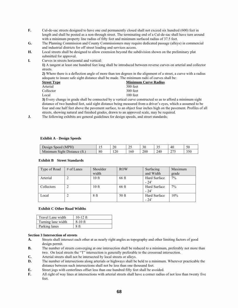
68
F. Cul-de-sac streets designed to have one end permanently closed shall not exceed six hundred (600) feet in length and shall be posted as a non-through street. The terminating end of a Cul-de-sac shall have turn around with a minimum property line radius of fifty feet and minimum surfaced radius of 37.5 feet.
G. The Planning Commission and County Commissioners may require dedicated passage (alleys) in commercial and industrial districts for off street loading and services access.
H. Local streets shall be designed to allow extension beyond the subdivision shown on the preliminary plat submitted for approval.
I. Curves in streets horizontal and vertical: 1) A tangent at least one hundred feet long shall be introduced between reverse curves on arterial and collector
streets. 2) Where there is a deflection angle of more than ten degrees in the alignment of a street, a curve with a radius
adequate to insure safe sight distance shall be made. The minimum radii of curves shall be: Street Type Minimum Curve Radius
Arterial 300 feet Collector 300 feet Local 100 feet
3) Every change in grade shall be connected by a vertical curve constructed so as to afford a minimum sight distance of two hundred feet, said sight distance being measured from a driver’s eyes, which a assumed to be four and one half feet above the pavement surface, to an object four inches high on the pavement. Profiles of all streets, showing natural and finished grades, drawn to an approved scale, may be required.
J. The following exhibits are general guidelines for design speeds, and street standards;
Exhibit A - Design Speeds
Design Speed (MPH) 15 20 25 30 35 40 50 Minimum Sight Distance (ft.) 80 120 160 200 240 275 350
Exhibit B Street Standards
Type of Road # of Lanes Shoulder
width ROW Surfacing
and Width Maximum grade
Arterial 2 10 ft 66 ft Hard Surface - 24’
7%
Collectors 2 10 ft 66 ft Hard Surface - 24’
7%
Local 2 8 ft 50 ft Hard Surface - 24’
10%
Exhibit C Other Road Widths
Travel Lane width 10-12 ft Turning lane width 8-10 ft Parking lanes 8 ft
Section 3 Intersection of streets A. Streets shall intersect each other at as nearly right angles as topography and other limiting factors of good
design permit. B. The number of streets converging at one intersection shall be reduced to a minimum, preferably not more than
two. On local streets the “T” intersection is generally preferable to the crossroad intersection. C. Arterial streets shall not be intersected by local streets or alleys. D. The number of intersections along arterials or highways shall be held to a minimum. Wherever practicable the
distance between such intersections shall not be less than one thousand feet. E. Street jogs with centerlines offset less than one hundred fifty feet shall be avoided. F. All right of way lines at intersections with arterial streets shall have a corner radius of not less than twenty five
feet.
69
Section 4 Access Roads A. Access roads shall intersection arterials, collectors, and other local rural streets and roadways at as near to right
angles as topography and good design allows. B. Access roads shall be limited to one per every quarter mile. C. The cost of installing all access roads including culverts shall be the responsibility of the developer. D. Frontage roads between access roads, when necessary, shall be installed according to the road design standards
and the installation shall be the responsibility of the developer. Section 5 Easements A. Easements across lots of centered on rear or side lot lines shall be provided for utilities where necessary and
shall be at least ten feet wide. B. Where subdivisions is traversed by a water course, drainage way, canal, or stream, there shall be provided a
storm water easement or drainage right of way conforming substantially with the lines of such water course, and such further width or construction, or both, as will be adequate for the purpose. Parallel streets or parkways may be required in connection therewith.
Section 6 Blocks A. The lengths, widths and shapes of blocks shall be suited to the planned use of the land, zoning requirements,
need for convenient access, control, and safety of street traffic, and the limitations and opportunities of topography. Block lengths in residential areas shall not as a general rule be less than six hundred feet in length between street lines unless dictated by exceptional topography or other limiting factors of good design.
B. Pedestrian ways or crosswalks, not less than ten feet in width, shall be provided near the center and entirely across any block nine hundred feet or more in length where deemed essential, in opinion of the Planning Commission, to provide adequate pedestrian circulation or access to schools, shopping centers, churches or transportation facilities. Said pedestrian ways shall be dedicated to the public use unless other written agreement, deed restriction, etc., guarantees maintenance. To the extent practical, subdivision design should give high priority to the convenience and safety of the pedestrian.
C. All utility lines for electric power and telephone service shall be placed underground except where, in the opinion of the Planning Commission, such location is unfeasible or too costly. Poles for permitted overhead lines shall be placed in rear lot line easements.
Section 7 Lots A. The size, shape, and orientation of the lots shall be appropriate for the location of the subdivision and for the
type of development and use contemplated. The lots should be designated to provide an aesthetically pleasing building site and a proper architectural setting for the buildings contemplated.
B. Minimum lot dimensions for residential type subdivisions shall conform to the requirements for the County Zoning Regulations.
C. Where residential lots border a railroad right of way, the depth of adjacent lots shall be increased by at least twenty-five feet more than the otherwise required minimum.
D. The depth of the lot shall not exceed three times it width.
Article 4 Required Improvements
A. Monuments shall be placed at all block corners, angle points, points of curves in streets and at intermediate points as shall be required by the engineer. The monuments shall be of such material, size and length as required by State Survey requirements.
B. Utility and street improvements 1) Utility and street right of way shall be provided in each new subdivision in accordance with the requirements
stated herein. C. The following minimum improvements shall be required by the County before any subdivision is approved: 1) Sidewalks; 2) Street grading and hard surfacing; 3) Street name signs; 4) Street lights; 5) Bridges, culverts or other drainage facilities; 6) Complete public water system if required approved by the State of Nebraska;
7) Complete public sewage collection and treatment system if required approved by the State of Nebraska 8) Other improvements that maybe required by the County.
70
D. The following minimum improvements may be required by the County before any subdivision is approved: 1) Curb and gutter; 2) Paved alleys; 3) Paved streets 4) Fire fighting system approved by the appropriate fire department. E. Subdivisions with lots one acre or greater in area maybe exempt from C.1, C.2, and C.4 as stated above if so
approved by the County. F. Subdivisions with lots five areas or greater in area maybe exempt from C.1, C.2, C.4, C.7, and C.8 as stated
above if so approved by the County.
Article 5 Public Lands and Reservations
A. Before final plat approval is given to the developer, shall be required to dedicate to the public use all streets, alleys, buffer strips and parks as may be required by the Planning Commission. Acceptance of these dedicated lands shall be recorded in the minutes of the county commissioners and on the subdivision plat.
B. Open park and recreation space shall be provided in the amount defined in the Zoning Regulations. This amount varies depending on the density of the proposed project.
C. Developers of commercial and industrial subdivisions may be required to dedicate land for off street parking as determined necessary by the Planning Commission.
D. Before final plat approval is given the developer, may be required to reserve sites for schools and emergency services facilities as determined by the Planning Commission and County Board to be sufficient and in compliance with the Comprehensive Plan. Reservation of land for public acquisition shall be for a period not to exceed three years from the date the plat is officially recorded.
E. Interior streets within a subdivision shall be maintained by the developer or a property owners association established by the developer until such time as the County accepts maintenance responsibility for said streets.
Article 6 Operation-Maintenance and Private and Field Entrance
A. It is the stated intent of the County to primarily provide rural and countywide services. It is not intended that the
County be obligated to provide urban services, i.e., utility systems maintenance, park maintenance, local road maintenance and related services normally required in housing projects. Therefore, it will be the obligation of the developer to present to the County Planning Commission and the County Commissioners a precise approach to handling and providing these services. Said approach may include the formation of districts, homeowners’ organizations or other methods to operate and provide for long-term maintenance and service. Said approach shall be made binding on the developer in a form, agreement of contract in a manner which is accepted by the County Commissioners.
B. The intent is to make uniform procedures for constructing and maintaining private and field entrances from county roads and for the safety and convenience of the traveling public. The County will request the landowner to consider the use of a frontage road when selling acreages that borders a county road. All entrances existing before January 1, 1996 will be allowed, unless the County finds a serious safety situation which would cause danger to the user or the traveling public.
C. When a private or field entrance is desired the party will make a written application to the Keith County Highway Department stating, 1) the need for the entrance, 2) width desired, and 3) any drainage requirements.
A physical examination is required by the County Highway Superintendent, the applicant will be notified of the action in writing. If drainage is involved with the construction the County will require the applicant to purchase drainage pipe in a size that will ensure adequate drainage and meet State of Nebraska specifications. The County will install the drainage pipe; the applicant will pay the cost of installation and maintenance after installation.
Article 7 Variances A. The Planning Commission may recommend and the legislative body may grant variances from the provisions of
the regulations but only determining that: 1) There are unique circumstances of conditions affecting the property.
2) The variance is necessary for the reasonable and acceptable development of the property in question. 3) The granting of the variance will not be detrimental to the public welfare or injurious to adjacent property.
B. The requirement of filing and recording a plat for subdivision shall not be waived.
71
C. The Planning Commission and County Commissioners may also grant reasonable variances to these regulations if the developer concurrently submits an application for, and obtains approval of, a large scale development. The developer shall indicate where the plans vary from these regulations and shall present sufficient evidence to support the request, indicating why the request will not be detrimental to the public health, safety and welfare.
Article 8 Amendments
Any provisions of these regulations from time to time may be amended, supplemented, changed, modified or repealed by the governing body according to the law; provided, however, that such amendments, supplements, changes, modifications or repealed provisions shall not become effective until after study and report by the Commission.
Article 9 Interpretation In the interpretation and application of the provisions of this resolution, the following regulations set forth below shall govern. Section 1 Provisions are Minimum Requirements In their interpretation and application, the provisions of this resolution shall be regarded as the minimum requirements for the protection of the public health, safety, comfort, and morals. Convenience, as remedial and shall be liberally constructed to further its underlying purpose. Section 2 Application of Overlapping Regulations Whenever both a provisions of this resolution and any other provisions of this resolution or any provision in any other law, resolution, rule or regulation of any kind, contain any restrictions covering any of the same subject matter, whichever restrictions are more restrictive or impose higher standards or requirements shall govern. All uses and, all area, width and yards permitted under the terms of this resolution shall be in conformity with all other provisions of law. Section 3 Existing Permits and Private Agreements This resolution is not intended to abrogate or annul: A. Any permits issued before the effective date of this resolution or B. Any easement, covenant or any other private agreement.
Article 10 Severability It is hereby declared to be the legislative intent that the several provisions of this resolution shall be severable in accordance with the provisions set forth below. Section 1 Provisions Declared Invalid If any provision of this resolution is declared to be invalid by a decision of any court of competent jurisdiction, it is hereby declared to be the legislative intent that: A. The effect of such decision shall be limited to that lot, building, other structure of tract of land immediately
involved in the controversy, action or proceeding in which the judgment or decree of invalidity was rendered. B. Such decision shall not affect, impair or nullify this resolution as a whole or the application of any provisions
thereof to any other lot, building, other structure or tract of land.
Article 11 Repeals and Enactment A. All resolutions of the County inconsistent herewith to the extent of such inconsistency, and no further, are
hereby repealed. B. The repeal of any of the above-mentioned does not revive another resolution or portions thereof repealed by
said resolutions. C. Such repeals shall not affect or prevent the prosecution or punishment of any person for the violation of any
resolution repealed hereby for any offense committed prior to the repeal. That this resolution shall take effect and be in full force from and after its passage and publication as required by law.

72
Appendix 1 Fee Schedule

73
1. Land Use Permits for non commercial, on site farm
storage or processing buildings or agricultural, horticultural, aqua or silva cultural products.
No charge.
2. Building permit for farm and non-farm residential
structures, excluding mobile homes. $.20 per sq/ft, $30.00 Minimum.
3. Building permit for farm and non-farm residential
garages. $.10 per sq/ft, $30.00 Minimum.
4. Building permit for non-farm accessory buildings over
200 square feet. (Other than residential garages as defined in zoning ordinance.)
$.10 per sq/ft, $30.00 Minimum or $3.00 per $1000.00 of construction cost, whichever is greater.
5. Building permit for fences, patios and other non
building structures. $30.00 or $2.00 per $1000.00 of construction cost,
whichever is greater. 6. Building permit for non-farm residential alterations. $30.00. 7. Building permits for agricultural and non agricultural
commercial and industrial structures. $.20 per sq/ft, $30.00 Minimum or $3.00 per $1000 of
construction cost, whichever is greater. In no circumstance shall the permit fee exceed $10,000.00
8. Building permit for mobile home placement on private
lot. $.20 per sq/ft, $30.00 Minimum.
9. Building permit for mobile home placement in
approved mobile home park. $50.00.
10. Building permit for dismantling unsafe buildings and
structures. No Charge.
11. Building permit to install septic system. $30.00. 12. Building permit to drill for potable water well. $30.00. 13. Certificate of Occupancy. No charge. 14. Conditional Use application. $150.00 in addition to building permit fee plus any fees
involved in consultants reviews. $150.00 for a large scale development plus $30.00 per dwelling unit proposed if residential, or .20 cents per square foot request for commercial or industrial plus any fees involved with consultants review.
15. Zoning Amendment $150.00. 16. Subdivision Preliminary Plat fee. $150.00 + $30.00 per lot created. 17. Subdivision Final Plat fee, Re-plat fee or
Administrative Re-plat fee. $50.00 + $5.00 per lot. In addition, the Developer shall
pay any consultant fees charged for review of the subdivision and infrastructure plans.
The preliminary plat fee may be waived if the development is associated with and processed with a conditional use permit.
18. Minor Subdivision Final Plat Fee. $50.00 + $5.00 per lot. 19. Application to Board of Adjustments. $150.00.

74
20. Right of way permit for non farm driveways and utilities.
$25.00 per driveway.
21. Right of way permit for agricultural use. No fee.
The indicated fee shall accompany any application for the above. Construction without a permit. Anyone who applies for a building permit after construction or alteration has already commenced will be required to pay double the regular fee, as set out in the fee schedule above, with a minimum fee of $60.00 for such a permit.