karst limestone geohazards in egypt and saudi arabia
TRANSCRIPT

International Journal of Geoengineering Case Histories ©, Vol. 2, Issue 4, p. http://casehistories.geoengineer.org
258
Karst Limestone Geohazards in Egypt and Saudi Arabia
Samir Abdeltawab, Professor of Engineering Geology, Ain Shams University, Dept. of Geology, Cairo, Egypt; email: [email protected] ABSTRACT: Three areas in Egypt and Saudi Arabia were selected as pilot sites for studying karst foundation problems.
Globally, the dissolution of carbonate rocks results in extensive karst landforms that can pose significant challenges to civil
engineering projects. Most karst caves and sinkholes are structurally controlled by major faults and joints. Detection of
karst limestone foundation bedrock (caves, sinkholes and open fractures) in the three studied sites has been conducted
using geological and geophysical studies. The geological studies are based on review of published geologic maps for the
three sites. The geophysical studies included a 2D electrical resistivity survey and ground-penetrating radar (GPR). Karst
limestone foundation bedrock treatments have been performed in several projects worldwide and include engineering fill,
engineering fill with geosynthetics, concrete filling and cement grout low pressure injection. Upper Egypt’s El Minia-
Maghagha caves, underlying newly constructed settlement areas have been treated using high-slump concrete filling.
Engineers treated foundations in northwestern Riyadh City and in eastern Al Hofuf City, Saudi Arabia, using engineering
fill, high slump concrete filling and low pressure cement grout injection. This article summarizes the classification of
encountered karst foundation bedrock according to Ford and Williams (1989) engineering classification, introduces the
optimum methods for detecting karst features and presents engineering treatments of karst limestone landforms.
KEYWORDS: Karst limestone, Geohazards, Detection, Treatments.
SITE LOCATION: IJGCH-database.kmz (requires Google Earth)
INTRODUCTION
Karst occurs primarily in limestone and dolomitic rock masses. Cavities and dissolution landforms form most commonly on
competent, fractured rocks whose intact unconfined compressive strength generally ranges between 30 and 100 MPa. Low
strength limestone, chalk and unlithified carbonate sediments lack the strength to span large cavities, and develop limited
karst features that are generally smaller than those on stronger limestone formations (Jennings, 1968 and Kannan, 1999).
Worldwide, insufficient understanding of karst limestone bedrock has led to serious construction problems and high costs.
A complete understanding of the nature of karst as well as the surface and subsurface detection methods used are very
important to avoid the risk of sudden collapse.
The karst limestone foundation bedrock at three studied localities are shown in Figure 1 (El Minia-Maghagha plateau,
northwestern part of Riyadh City and eastern part of Al Hofuf City). These areas pose several engineering challenges
related to the construction process and project time schedule as well as project cost impact. The main objectives of this
article are to classify the encountered karst foundation bedrock, according to Ford and Williams (1989) engineering
classification, and introduce the optimum methods for detection and engineering treatment.
Submitted: 30 January 2013; Published: 19 December 2013
Reference: Abdeltawab, S. (2013). Karst Limestone Geohazards in Egypt and Saudi Arabia. International Journal of
Geoengineering Case histories, http://casehistories.geoengineer.org, Vol.2, Issue 4, p.258-269. doi: 10.4417/IJGCH-
02-04-02

International Journal of Geoengineering Case Histories ©, Vol. 2, Issue 4, p. http://casehistories.geoengineer.org
259
Figure 1. Google Earth satellite image showing the locations of studied areas (1-El Minia Maghagha Plateau, 2-
northwestern part of Riyadh City and 3- eastern part of Al Hofuf City).
KARST MORPHOLOGY
The karst geomorphology is a distinctive terrain developed on soluble rocks (carbonates and evaporates) with landforms
affected by underground drainage. Disrupted surface drainage, sinkholes and caves, open fractures and pinnacles are the
main diagnostic features that characterize these types of landforms. The geometric complex natural cave passages create
uniquely difficult ground conditions for civil engineering (Sowers, 1996 and Waltham et al., 2003). Solid limestone of high
bearing capacity is interspersed with open and sediment-filled voids as well as pinnacles at shallow depth that complicate
foundation design, subsurface homogeneity, integrity and excavatability. The unpredictability of these features underlying a
proposed engineering project increases the challenges for the ground engineer.
The three studied areas in karst limestone foundation bedrock have an average compressive strength of 30 MPa which is
favorable to form relatively large size caves, sinkholes and open fractures with an average cross-section diameter of not less
than 3 m. The main geomorphologic features observed in the studied areas include pinnacled rockhead, buried sinkhole,
caves and fissured rockhead.
STRATIGRAPHY OF STUDIED KARST LIMESTONE
El Minia–Maghagha plateau karst limestone: The El Minia-Maghagha plateau lies parallel to the eastern
bank of Nile River and is mainly composed of Middle Eocene carbonate rocks (Bishay, 1961, Said, 1962 and
Philip et al., 1991). The oldest exposed unit is the El Minia Formation which is composed of white, hard,
cavernous and fossiliferous limestone and chalk intercalated with thin beds of sandy, cherty and clayey
limestone. The El Minia formation is conformably overlain by the Samalut formation which is composed of
snow white, moderately hard, cavernous, fossiliferous limestone. These two Middle Eocene units are
characterized by karst geomorphology of shallow and deep caves, open fractures, and connected old drainage
channels (as shown in Figure 2. a-d). In most of the site, the observed caves and sinkholes are controlled by
major faults and master joints trending NW (Abdeltawab et al.1991 and Abdeltawab,1994 and Abdel-Meguid
et al.1998).

International Journal of Geoengineering Case Histories ©, Vol. 2, Issue 4, p. http://casehistories.geoengineer.org
260
Figure 2.a. El Minia-Maghagha Plateau karst limestone: evidence of the process of solution and erosion along existing
joints (fissured rockhead), b. Group of sinkhole top circular opening along N 300˚ trending Joints, c. Developed large size
caves, d. Solution caves at NW trending normal fault at El-Minia El-Gidida City.
Riyadh Karst Limestone: The northwest part of Riyadh, Saudi Arabia’s capital and largest city, is mainly
founded on two units of limestone bedrock which have high potential of developing karst caves, sinkholes and
open fractures. The first exposed unit is a NW-SW limestone belt at the eastern side of Riyadh city and is
known as the Sulaiy Limestone Formation of the Cretaceous age (Geologic map of Riyadh Quadrangle,
1991). The Sulaiy Formation is typically composed of compacted limestone with a few thin calcareous beds.
On outcrops, this formation exhibits slumping features in its lower beds identical to the features found in the
Arab Formation. The higher beds, however, are unaffected by slumping and are moderately strong, forming
erosion-resistant, well-defined steep scarp slopes. Cavities and sinkholes are most commonly formed in the
lower beds of this formation at the contact with the Arab Formation rather than the upper beds as they are
formed mainly of compacted limestone. The second karst unit belongs to the Jurassic limestone of the Arab
Formation. This formation is outcropping as NW-SE trend of limestone belt at the west side of the Riyadh.
The formation is mainly made up of limestone and evaporites. The Arab Formation is the main rock unit
underlying the Riyadh. It is considered the most susceptible to development of solution cavities. This could be
attributed to either the dissolution of evaporites, or the nature of the limestone, which is in the form of
limestone boulders within an extremely soluble matrix of softer dolomitic limestone. The limestone unit is
thin bedded and shows high deformation (structural slumps) phenomena that resemble brecciated rocks
(Figure 3).

International Journal of Geoengineering Case Histories ©, Vol. 2, Issue 4, p. http://casehistories.geoengineer.org
261
Figure 3.a. Riyadh project bedrock foundation; Karst limestone pinnacles; b. Buried sinkhole filled with weakly cemented
sand, c and d. Solution caves in the bedrock foundation. Letter designation in Figures a and b represent S for sandstone
and L for limestone
Al Hofuf karst limestone: The eastern part of Al Hofuf city is mainly founded on limestone bedrock, which
has a high potential for karst caves, sinkholes and open fractures. The main unit affected by karst geomorphic
features is the Hofuf Formation that is of the Miocene-Pliocene age. The Hofuf Formation consists
dominantly of white to light grey, massive, calcareous marl and sandstone with intermittent horizons of soft,
reddish to yellowish brown marl and clay. The study area has famous tourist caves and a sinkhole (Jabal Al
Qarah) located approximately 13 km east of Al Hofuf City. These caves and sinkholes are developed in the
calcareous sandstone, marl and clay of the Hofuf Formation. The eastern edge of the Jabal Al Qarah sinkhole
is close to the cavity entrance and is interpreted to be bounded by several north-south trending high-angle
normal faults with a down throw displacement of about 10 m (Hussain et al. 2006).

International Journal of Geoengineering Case Histories ©, Vol. 2, Issue 4, p. http://casehistories.geoengineer.org
262
Figure 4.a. and b. El-Ahasa bedrock foundation showing the occurrences of caves and open fractures; Karst caves and
fractures filled with silty clay materials, c. and d. Hollow shallow caves.
ENGINEERING CLASSIFICATION OF KARST GROUND
Ford and Williams (1989) provided an engineering classification of karst conditions that essentially represents simplified
guidelines to the potential variation in landforms and ground cavities that may be encountered in civil engineering works on
karst. This classification divided the karst ground into five classes. The five classes provide the basis of an engineering
classification that characterizes karst in terms of the complexity and challenges to be encountered by the foundation
engineer. The advantage of using this classification, compared to geological or geomorphological classifications, is that it
combines geological observations and engineering parameters. This combination allows for a more comprehensive
evaluation for engineering purposes and provides design parameters that can help the foundation engineer understand karst
ground complexity. The five classes per Ford and Williams (1989) can be summarized as following:
K I: This type is mainly encountered in deserts and periglacial zones. It is characterized by impure carbonitic
sinkholes, uniform rockheads, minor fissures, and low secondary permeability. Caves are rare and small and
some isolated relict features are present.
K II: This type is encountered in low temperate regions. It is characterized by small suffusion or dropout
sinkholes, open stream sinks, and numerous small fissures. Fissures are widespread in the few meters closest
to the surface. Caves are many and small with sizes less than 3 m across.
K III: This type is mainly encountered in temperate regions in the wet tropics. It is characterized by many
suffusion and dropout sinkholes, large dissolution sinkholes, small collapses and buried sinkholes, extensive
fissuring, reliefs less than 5 m, loose blocks in cover soils, and extensive secondary openings of most fissures.
Caves are many with sizes less than 5 m across at multiple levels.
K IV: This type is mainly encountered in normal tropical regions. It is characterized by many large dissolution
sinkholes, numerous subsidence sinkholes, scattered collapse and buried sinkholes, pinnacles (with geological
International Journal of Geoengineering Case Histories ©, Vol. 2, Issue 4, p. http://casehistories.geoengineer.org
263
reliefs of 5-20 m), loose pillars, extensive large dissolution openings on and away from major fissures. Caves
are many (size greater than 5 m across at multiple levels).
K V: This type is mainly encountered in wet tropics. It is characterized by very large sinkholes of all types,
remnant arches, soil compaction in buried sinkholes, tall pinnacles (reliefs of greater than 20 m), loose pillars
undercut between deep soil fissures, abundant and very complex dissolution cavities, numerous complex 3-D
cave systems, galleries and chambers (caves greater than 15 m across in size).
ENGINEERING CLASSIFICATION OF THREE STUDIED KARST LIMESTONE AREAS
El Minia-Maghagha Plateau: The limestone units at this plateau have many suffusion and dropout sinkholes as well
as large dissolution sinkholes, small collapse and buried sinkholes, extensive fissuring; reliefs less than 5 m, loose
blocks in cover soil, and extensive secondary openings of most fissures. Caves are many (size less than 5 m across at
multiple levels). The strength parameters after Abdeltawab (1994) are as follows:
El Minia Formation: Average unconfined compressive strength = 39 MPa and Young modulus = 32 GPa
Samalut Formation: Average unconfined compressive strength = 39 MPa and Young modulus = 32 GPa.
The karst limestone encountered at El Minia-Maghagha Plateau can be classified per Ford and Williams (1989)
engineering classification as Class K III.
Riyadh: The limestone units at Riyadh have many large dissolution sinkholes, numerous subsidence sinkholes,
scattered collapse and buried sinkholes, pinnacles (as shown in Figure 3), reliefs of 5-20 m, loose pillars, and extensive
large dissolution openings on and away from major fissures. Caves are many (with diameter greater than 5 m across at
multiple levels). The average strength parameters of Riyadh’s bedrock foundation as measured by Alawaji et al. (2006)
are as follows:
Average unconfined compressive strength = 30 MPa
Average Young modulus = 40 GPa
The karst limestone encountered at the El Minia-Maghagha Plateau can be classified as Class K IV (per Ford and
Williams, 1989).
Al Hofuf City: The limestone units at Al Hofuf City have many large dissolution sinkholes, numerous subsidence
sinkholes, scattered collapse and buried sinkholes, pinnacles (as shown in Figure 4), reliefs of 5-20 m, loose pillars,
and extensive large dissolution openings on and away from major fissures. Caves are many (with diameter greater than
5 m across at multiple levels). The average strength parameters of Riyadh’s bedrock foundation (after Site
Investigation Report SAFCO, 2008) are as follows:
Average unconfined compressive strength = 32 MPa
Average Young modulus = 24 GPa
The karst limestone encountered at Al Ahesa City can be classified as Class K IV (per Ford and Williams, 1989).
METHOD OF CAVES AND SINKHOLES DETECTION
Karst limestone foundation bedrock caves, sinkholes and open fractures have been studied using several methods,
specifically geomorphologic studies and measurements, geologic mapping and geophysical survey. The most effective and
applicable methods used to detect the karst anomalies in the three studied sites can be summarized as follows:
Geological Maps: Studying the main geologic units of the project foundation bedrock from the available
published geologic maps, geology papers and reports is a very good start for assessing the expected karst
foundation problems. Also preparing detailed geologic maps for the proposed project including lithologic
descriptions showing joints, fractures and fault zones facilitates the prediction of the distribution of these karst
units laterally and with depth. The geologic desk studies and mapping represent the first phase of a site’s
geotechnical investigation program. The geologic studies represent the most economical and quickest method
for predicting and evaluating the risk of karst foundation bedrock. The geologic studies that have been done

International Journal of Geoengineering Case Histories ©, Vol. 2, Issue 4, p. http://casehistories.geoengineer.org
264
for the three sites give very strong indications of the existence of karst foundation bedrock hazards. Project
designers used this geologic data to add new project tasks including detection of karst features under the
proposed buildings as well as treatment of the detected karst features.
Ground-Penetrating Radar (GPR) Survey: Ground-penetrating radar (GPR) techniques have been
progressively developed and used for several types of engineering foundation problems. Karst limestone
caves, sinkholes and open fractures can be successfully detected in dry areas by using GPR surveying. The
basic concept of GPR is to transmit and receive electromagnetic waves of wide spectrum frequencies (100
MHZ to 500 MHz) and process the received waves to detect shallow underground anomalies, such as caves
and sinkholes. The karst limestone foundation bedrock at the eastern part of the Al Hofuf project have been
surveyed in a GPR profile grid using electromagnetic waves that have frequencies ranging between 100 MHz
and 500 MHz . The instruments that were used were RAMAC-GPR devices and software. The digital profiles
were processed and plotted (wiggle trace format) using REFLEX and RAMAC software. The processed data
indicate the presence of shallow caves and open fractures (Figure 5). The detected GPR anomalies were
verified using mechanical probing to determine the accurate depth and to start the treatment process.
Figure 5. Eastern part of Al Hofuf City GPR karst limestone survey, A-Sinkhole/cave from 1 to 10 m depth,
B-Open fracture from 1 to 11 m depth.
2D electrical resistivity survey: The SYSCAL Pro Switch units involve the concurrent placement of a large
number of electrodes along a line and the execution of an automated switching of these electrodes to acquire
profiling data. The apparent resistivity pseudo-sections measured with such a technique were processed by
inversion software which yielded the interpreted resistivity and depth values for the anomalies detected along the
profile. This technique is called resistivity imaging or electrical resistivity tomography (ERT). The objective of
using the 2D electrical resistivity imaging in the studied areas was to detect any suspected anomaly or any
lithological variations such as cavities, soil layers, and water conditions. Two-dimensional (2D) electrical
resistivity imaging was conducted at the Riyadh and Al Hofuf projects to map the subsurface structures. The
surveying process was acquired using the Winner-Schlumberger configuration with different lengths, but with a
constant 2 m interval electrode spacing. Quality of both data acquisition and processing was maintained at a high
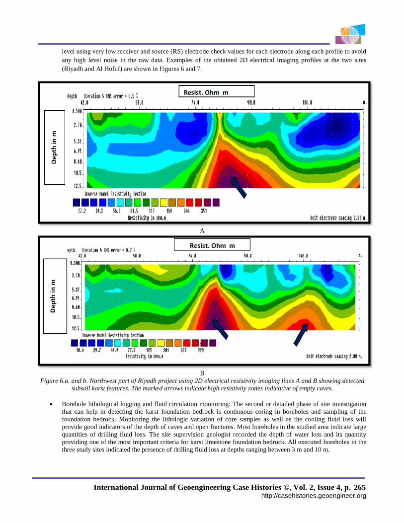
International Journal of Geoengineering Case Histories ©, Vol. 2, Issue 4, p. http://casehistories.geoengineer.org
265
level using very low receiver and source (RS) electrode check values for each electrode along each profile to avoid
any high level noise in the raw data. Examples of the obtained 2D electrical imaging profiles at the two sites
(Riyadh and Al Hofuf) are shown in Figures 6 and 7.
A
B
Figure 6.a. and b. Northwest part of Riyadh project using 2D electrical resistivity imaging lines A and B showing detected
subsoil karst features. The marked arrows indicate high resistivity zones indicative of empty caves.
Borehole lithological logging and fluid circulation monitoring: The second or detailed phase of site investigation
that can help in detecting the karst foundation bedrock is continuous coring in boreholes and sampling of the
foundation bedrock. Monitoring the lithologic variation of core samples as well as the cooling fluid loss will
provide good indicators of the depth of caves and open fractures. Most boreholes in the studied area indicate large
quantities of drilling fluid loss. The site supervision geologist recorded the depth of water loss and its quantity
providing one of the most important criteria for karst limestone foundation bedrock. All executed boreholes in the
three study sites indicated the presence of drilling fluid loss at depths ranging between 3 m and 10 m.

International Journal of Geoengineering Case Histories ©, Vol. 2, Issue 4, p. http://casehistories.geoengineer.org
266
A
B
Figure 7.a. and b. Eastern part of Al Hofuf City 2D electrical resistivity imaging lines A and B showing detected subsoil
karst features. The marked arrows indicate high resistivity zones of empty caves.
Mechanical Probes: Mechanical probes used pneumatic percussive drilling with a probe hole diameter of 50 mm.
The mechanical probes represent the final and more accurate tool for detecting the depth of caves and sinkholes by
observing the rate of drilling in relation to depth. The caves and sinkhole zones usually have an abrupt decrease in
the recorded drilling time (drilling rate) and sudden drop of drilling rods. The mechanical probe and resulting
curve are shown in Figure 8. The mechanical probe holes have a dual function, specifically the karst feature depth
determination and the treatment by dumping concrete or cement grout through the probe hole.

International Journal of Geoengineering Case Histories ©, Vol. 2, Issue 4, p. http://casehistories.geoengineer.org
267
A B
Figure 8.a. and b. Mechanical probing for detecting caves and sinkholes in limestone bedrock foundation covered by
quaternary cemented sand. A shows the probe machine and B shows the probe curve as well as the time-depth relation
indicating the presence of caves at depth of 8.6 m.
CAVES AND SINKHOLE TREATMENTS
The karst limestone caves, sinkholes and open fractures cause severe damage to buildings globally and the main target of
site investigation geotechnical programs is to evaluate the vertical and lateral distributions of these foundation problems
and adopt the most economic solution for treatment. Several engineering methods have been used worldwide in several
projects and include engineering fill, engineering fill and geosynthetics, concrete filling and cement grout low pressure
injection. The most common techniques of karst treatment are based on concreting and cement grout injection filling. The
author has reservation on using concreting and injection work for filling the caves and open fractures in the areas that have
shallow groundwater aquifers. The concreting and injection work will close all underground drainage channels and also will
pollute the groundwater aquifer. The three studied sites are treated by using concrete filling and cement grout low pressure
injection. The process of foundation bedrock treatment can be summarized as follows:
At the final excavation level, any cavities/fissures and solution channels encountered at rock surface or slightly
below rock surface shall be exposed, trimmed, cleaned and then filled with engineering fill materials if the cave
and sinkhole size can be properly compacted to minimize the expected risk of fill material settlement (Figure 4a
and b).
The near surface narrow open fractures in caves as well as the solution channels that are less than 1 m in width can
be treated by manual cleaning of the silt and loose material and by then filling with high slump concrete (Figure 9
c and d).
The relatively deep (greater than 2 m depth) caves and sinkholes can be treated by high slump concrete or cement
grout low pressure injection (Figure 9 c and d).

International Journal of Geoengineering Case Histories ©, Vol. 2, Issue 4, p. http://casehistories.geoengineer.org
268
Deeper cavities can be treated by pumping cement-grout or cement-sand grout mixtures through an injection
packer system fixed on top of the probe holes (Figures 9 a and b). The grouting will be started with the specified
grout mix until the cave is completely filled and refusal is achieved under a maximum 0.2 MPa (2 bar) pressure. In
the case of multiple cavities in any drill hole, treatment shall proceed from the lowest cavity and be completed for
that cavity before proceeding to the next shallower cavity.
A
B C D
Figure 9.a. and b. Karst foundation bedrock treatments; cement grout injection, c. and d. high slump concrete filling.
CONCLUSIONS
The three studied sites (El Minia-Maghagha Plateau, Riyadh and Al Hofuf are good examples of karst limestone foundation
bedrock problems. Collaborative desk studies between the geotechnical engineer, engineering geologist and geophysical
consultant resulted in a very sound evaluation of how to detect the foundation bedrock karst features. The following lessons
can be derived from this study:
Geologic and geomorphologic desk studies should be provided prior to any site geotechnical investigation phase.
The obtained geologic and geomorphologic maps should be used as a guide for geophysical survey task to
minimize the effort and cost.

International Journal of Geoengineering Case Histories ©, Vol. 2, Issue 4, p. http://casehistories.geoengineer.org
269
GPR and 2D electrical resistivity imaging are very good detection methods for identifying karst features (caves,
sinkholes and open fractures). However, GPR is ineffective in areas of high water content or shallow groundwater
aquifers.
Geophysically detected anomalies can be easily verified using mechanical probes.
Karst feature treatment options are compacted engineering fill, engineering fill with geosynthetics as
reinforcement, concrete filling and cement grout filling.
For sites with shallow groundwater, the use of concrete filling should be minimized. In this case, coarse aggregate
can be used as engineering fill material.
REFERENCES
Abdeltawab, S. and Ibrahim, H. (1991). "Unfavorable Geologic Setting of the New Minia City, Upper Egypt", Journal of
Engineering and Applied Science, Cairo University, Vol. 39, 421 – 429.
Abdeltawab, S. (1994)."A Geotechnical Evaluation of El-Minia - Maghagha Area, Upper Egypt", Journal of King
Abdulaziz University, Earth Sciences, Vol. 7, 143-157.
Ahmed, A. , Abdel-Meguid , Laila, A. Fayed , Mostafa, E. Mostafa and Mohamed, S. (1998) "Geotechnical and
Environmental Hazards in Desert New Cities: A Case Study of El Minia El Gedida Site", Egypt, Natural Hazards 17,
47–67.
Alawaji, H and Al Shinawy, A. (2006)." Evaluation and characterization of Northern Riyadh limestone" using pressure
meter test for foundation and underground structures analysis and design, KAC for Science and Technology, Final
Report (ARP-17-03), 1-148.
Bishay, Y.(1961). "Biostratigraphic study of the Eocene in Eastern Desert" between Samalut and Assuit by the large
foraminifera, Third Arab. Petrol. Congr., Alex. 2, 1–13.
Ford D.C. and Williams P.F. (1989)." Karst Geomorphology and Hydrology", Unwin Hyman, London, 601.
Geological map of Riyadh Quadrangle (1991). Sheet no. 241 scale of 1:250000.
Hussain, M. AL-Khalifah, F. and Khandaker, N. I. (2006). "The Jabal Al Qarah Caves of the Hofuf Area", Northeastern
Saudi Arabia: A geological investigation. Journal of Cave and Karst Studies, v. 68, no. 1, 12–21.
Jennings, J.N. (1968). "Syngenetic karst in Australia", Australia National University Department of Geography Publication
G/5, 41-110.
Kannan, R.C. (1999)." Designing foundations around sinkholes", Engineering Geology 52, 75-82.
Philip, G, El-Aref, M. and Ewais, S. (1991)."Pleo erosion surfaces and karst manifestation" including ( Egyptian
Alabaster) in Gebel Homret Schaibun-Gebel Sannur area east of Nile Valley, Egypt, Jour., Geol., V. 31, No. 1-2.
Said, R. (1962). The Geology of Egypt, Elsevier, Amsterdam, New York, 337.
Sowers G.F. (1996)." Building on Sinkholes", ASCE Press: New York, 202.
Soil and Foundation Co. Ltd. (2008)." Soil investigation report "of King Saud University for Health Sciences project, 1-59.
Waltham A. C. and Fookes, P. G. (2003)." Engineering classification of karst ground conditions", Quarterly Journal of
Engineering Geology and Hydrogeology, 2003, vol. 36, 101-118.

The International Journal of Geoengineering Case Histories (IJGCH) is funded by:
Email us at [email protected] if your company wishes to fund the ISSMGE International Journal of Geoengineering Case Histories.