julienne lake iron deposit - gov.nl.ca
TRANSCRIPT

Julienne Lake Iron Deposit
History, Evaluation and Path Forward

What is Julienne Lake? • The Julienne Lake deposit represents a large, undeveloped deposit
of iron ore located in Labrador West. It is situated 32 kilometres by road from the town and mine site of Wabush and 16 kilometres from the nearest point on the QNS&L railway.

Location

Aerial View

Early History • Discovered in 1953 by the Newfoundland and Labrador Company
(Nalco).
• By agreement with Nalco, Canadian Javelin Ltd. first examined the deposit in 1955.
• Exploration started in 1956 and a general resource of about 275 million tons of ore was estimated.
• In 1957-58, nine drill holes totaling 3,477 feet (1,060m) were completed.

Early History • Javelin’s preliminary estimate indicated 387 million tonnes at 34.2%
iron in “potential ore reserves”. • In 1963, Canadian Javelin revised the resource estimate to 508Mt
grading 34.2% iron with only trace impurities.
• In 1966, a warehouse fire destroyed all the remaining drill core.
• Canadian Javelin unsuccessful in attracting customers or buyers for the deposit.
• No further exploration or development work was conducted.

1975-1980 • In 1975, the rights to the deposit reverted to the crown under the
Julienne Lake Deposit (Reversion Act) 1975. The property was made an exempt mineral land and has remained under that status to this date.
• In 1975-76, the Mineral Development Division prepared a summary report of previous exploration and development work.
• In 1980, Hatch and Associates were retained to conduct a study into the potential of further iron ore development in the Province.
Phase I RFP 2009 • Request For Proposals Issued November.
• Key Objectives:
– Estimate degree of confidence in historical “reserve”. – Indicate if there was market interest in deposit and whether
exploration would add value to a potential sale. – Approximate the amount of exploration required to achieve
desired resource estimate.
• Phase 1 Report received early February, 2010.

Phase I RFP • Key Findings:
– Computer-generated block model suggestive of 460 million tonnes at 35% iron (non 43-101 compliant)
– Considerable uncertainty to historical data, particularly drill results
– Additional technical data required – Multi-faceted exploration program warranted and justified
• Surface trenching • Magnetometer survey • 7,000m of diamond drilling • Bench scale metallurgy • Preliminary pit model

Phase II RFP • Budget 2010 announced approval of $2.1 million for work program to
assess the potential market value of the deposit.
• Public tenders sought with closing date of May 7th. – define the deposit to the level of NI 43-101 compliant indicated and
measured resources – establish a reliable 3-D geological model to be used to generate
resource models at a range of cut-off grades – generate preliminary pit design models
• MPH Consulting signed contract on July 7th.
• Diamond drilling commenced on August 6th.
• By August 20th, it was apparent that the deposit was significantly larger than
anticipated. Previous geological model incorrect.

Phase II RFP
Original Javelin Section 10,000’E with DDH JL10-02,02A,02B and 03 in progress

Phase II RFP • Additional $500,000 funding approved for to increase the overall
amount of diamond drilling from 7,000m to 10,000m.
• Diamond drilling was completed on November 16th 2010 with a total of 9,238m drilled in 42 holes (34 drill sites).

Phase II Diamond Drilling

Phase II Diamond Drilling

Phase II Diamond Drilling • All drill holes collared in iron formation. • Good core recovery.

Trenching • 1,600m excavated in two trenches. • 104 channel samples analyzed. • Increase confidence level of continuity between drill holes.

Magnetometer Survey • 23.5 line-km ground magnetometer survey. • Increase confidence level of continuity between drill holes.

Baseline Environmental Survey
• Findings: – Literature review revealed no flora species designated at risk in
Labrador – No fauna species at risk detected during site visit – Variety of signs of human disturbance detected
• Caveat:
– On-site investigation not conducted during breeding or migration seasons

Archaeological Survey • Conducted to obtain exploration permit.
• No archaeological sites yet to be discovered in the Wabush Lake
and Julienne Lake areas.
• No historic resources were observed at surface level or recovered from 64 test pits during this survey.

Geology

Geology • The Julienne Lake
deposit is hosted by the Sokoman Formation, a sequence of iron-rich sedimentary rocks which are continuous throughout the Labrador Trough.
• Middle Iron Formation predominant unit at Julienne Lake.
• Regionally, Sokoman Fm rest conformably upon quartzites of the Wishart Formation.

Middle Iron Formation • Quartz-specularite schist is the
dominant rock type at Julienne Lake. – > 95% of the total thickness of
iron formation in the logged drill holes
– Ranges from medium to coarse grained semi-massive quartz-specularite schist (QS) to well banded QS with alternating quartz-rich and specularite-rich bands
– Magnetite is rare – Alteration is most likely related
to late stage fluid flow (deep weathering?)

Quartz-specularite schist of MIF

Sub-Units • Mn-rich iron formation comprises <2.5% of the total thickness of the
Middle iron Formation.
• Lean white quartzite makes up < 3% of the total thickness of iron formation. – unit is similar to the middle quartzite at Wabush Mines and may
prove a useful marker horizon.

Wishart Formation • The Wishart Quartzite defines
the footwall contact of the Sokoman Iron Formation at Julienne Lake. – Well-bedded in outcrop and is
strongly recrystallized with coarse grained quartz
– Contact with Lower Iron Formation in Trench 2 includes zones of quartz-muscovite schist (basal thrust?)
– Core recovery is poor, and the quartzite close to the contact with the iron formation is leached and friable

Structural Geology • Polyphase deformation with evidence of folding and thrust stacking.
• Abundant thrust-related features.
– Open to isoclinal, asymmetric, subhorizontal folds – Kink bands, S and C shear fabrics – Abundant cataclastites – Locally observed transposition of S1into S2 (parallel) – Mineral stretching lineations developed on S1
• Compositionally, iron formation is relatively homogenous and internal
stratigraphy difficult to unravel.
• Chemostratigraphy may be useful.
• Economically important that Upper Iron Formation thrust out of sequence. Very thin slice of Lower Iron Formation at base of deposit.

Structural Geology

L1350E Interpretation • Appears deposit may
include a overturned syncline.
• Consistent with regional structural patterns recording NNE-trending folds and thrust repetition.

Phase II Summary • Deliverables included:
– ≈9,200m NQ diamond drilling, 1,175 core samples analyzed – 23.5 line km of linecutting and magnetometer survey – 1.6 km of trenching and surface sampling – Archeological survey – Baseline environmental survey – NI 43-101 Compliant Mineral Resource and Reserve Estimate – Potential pit model – Metallurgical testwork (ore characterization and beneficiation
studies)
• Total expenditure for Phase II $2,623,326.44

2011 Resource Estimate • 1.166 billion tonnes grading ≈ 33% iron at a cutoff grade of 15%
– 1,152 Mt at a cut-off of 25% iron.
• Measured Resources – 66 Mt at 34.68 % iron, 0.38%Mn, 0.01% P
• Indicated Resources – 801 Mt at 33.60% iron, 0.20% Mn, 0.01% P
• Inferred Resources – 299 Mt at 34.14% iron, 0.12% Mn, 0.01% P
• Conservative open-pittable resource of 580Mt grading 33% iron.
– Calculated excluding ore contained within 100m buffer to bounding water bodies.

Resource Block Model, 500m Plan
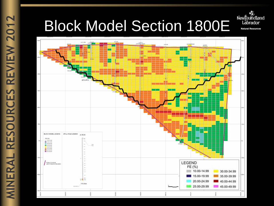
Block Model Section 1800E

Block Model Section 2100E

Block Model Section 9625N

Block Model Section 9850N

Block Model Section 10000N

Block Model Section 10150N

Pit Design

Manganese Distribution • High grade manganese
concentrations restricted to distinctive sooty horizons.
• Grades > 3% Mn represent 2.2% of the 1,175 sample dataset.
• Average intersected thickness ≈ 4.24m, true thickness lower.
• Average vertical depth 113m. • 56% 100m depth or less. • Expected that with increased
diamond drilling, the distribution of these horizons will be predictable.
• Predictability and distinct visual nature should allow for wasting of material >3% Mn.

Manganese Distribution • Spatial distribution of
Mn may be related to: – Supergene
enrichment along faults and f2 fold axis
– Restricted to upper thrust panel(s)
– Both? – More drilling
required

Metallurgical Test Results • Ore comprised of predominantly hematite and quartz with negligible
magnetite.
• An iron recovery of approximately 75% and a weight recovery of over 40% is indicated.
• Testwork indicated that it is possible to produce an iron ore concentrate with content of >66% Fe and a silica content of <5%.
• Autogenous or semi-autogenous grinding will likely be the preferred approach to milling the ore.
• Bond Work Index results show that the iron ore is soft.

Processing • Processing may prove to be
very simple without the requirement for regrind and a magnetite recovery circuit.
• High tension electrostatic separation of silica may not be necessary.

Favourable Mining Attributes • Negligible internal waste.
• Very low Life of Mine strip ratio of 0.20-1
– Preproduction-early mine life essentially zero
• High grade at or near surface.
• Soft ore. – Low grinding costs (positive aspect for equipment size,
capital/operating costs, energy requirements, maintenance) – Throughput not limited by hardness.
• Rapid payback.

Local Source of Aggregate • Pleistocene raised beach.
• Suitable for civil construction.
• Quarry Lease not required
within boundaries of Mining Lease.

Path Forward • On October 10, 2012 the department issued a Call for Expressions
of Interest for the development of the deposit. • Deadline for submissions is November 14th and require:
– List principals involved, including corporate financial background, ownership;
– Capabilities in mining, or other industrial activities; – Specific involvement with other projects of similar nature; – Current operations involving the transportation and/or
consumption of iron ore; – Ability to raise funds for the project; and – Brief outlines of proposed development plans.
• Detailed proposals will be solicited from those who have provided expressions of interest and who have a demonstrated ability to bring the Julienne Lake project to, at a minimum, a completed feasibility study stage.

Path Forward • Feasibility stage will require minimum of:
– Additional diamond drilling to upgrade resources to indicated or measured status
– More thorough ore characterization work – Complete engineering work
• Terms of reference will be provided for proposals but will not have
defined structure for potential agreement.
• The successful proponent will be granted exclusive mineral rights under the Mineral Act (Extended Map Staked Licence or Mining Lease).
• Commitments will be incorporated as terms and conditions of the
licence or lease.

Path Forward • Government is open to all ideas and options that ensure the
maximum benefit to the people of the Province. • Five aboriginal groups have been notified of the EOI and ensured
that consultations will be undertaken on the assessment of any potential impacts from development.

Summary • More than doubled the known geological resource estimate of a
significant iron ore deposit. • Acquired sufficient technical data to dispose of deposit while
realizing maximize benefit to the Province. • Project was complete on-time and on budget with zero time lost due
to injury.

What is Julienne Lake? • The Julienne Lake deposit represents a large, undeveloped deposit
of iron ore located in Labrador West. It is situated 32 kilometres by road from the town and mine site of Wabush and 16 kilometres from the nearest point on the QNS&L railway.
• “The Julienne Lake iron deposit represents a very rare and unusual
opportunity to develop a major new mining project in the heart of an established mining camp in a politically stable country”.