jordan lake state recreation area general management plan gmp.pdf · 2018-06-19 · jordan lake...
TRANSCRIPT

1
Jordan Lake
State Recreation Area
General Management Plan
North Carolina Department of Natural and Cultural Resources
Division of Parks and Recreation
Coastal Region
FEBRUARY 2017

2
I. MISSION AND PURPOSE
MISSION STATEMENT: Conservation: To protect North Carolina’s natural diversity through careful
selection and stewardship of state parks system lands;
Recreation: To provide and promote outdoor recreation opportunities in the state
parks system and throughout the state; and
Education: To encourage appreciation of North Carolina’s natural and cultural
heritage through diverse educational opportunities; for all citizens of and visitors
to the State of North Carolina.
PURPOSE: The State of North Carolina offers unique archaeologic, geologic, biologic,
scenic and recreational resources. These resources are part of the heritage of the
people of this State. The heritage of a people should be preserved and managed
by those people for their use and for the use of their visitors and descendants.
PARK PURPOSE: Filled in 1981, the B. Everett Jordan Lake was authorized by the U.S. Congress to provide for
flood control, water supply, water quality control, recreation, and fish and wildlife conservation.
The lake and dam are managed by the U.S. Army Corps of Engineers, Wilmington District.
Management of the lake and its surrounding public lands are done in coordination with the state
of North Carolina.
The 13,900 acre Jordan Lake and its associated recreation areas are a major statewide recreational
resources for land and water-based recreational activities. A variety of facilities encourage use of
the lake and provide opportunities for resource-compatible recreational activities such as fishing,
swimming, sunbathing, motor boating, waterskiing, wind surfing, sailing, picnicking, hiking, and
natural and cultural resource interpretation. Diverse overnight camping opportunities such as: tent
and trailer, group, primitive and recreational vehicle camping are available. A private concession
marina at Crosswinds operates for the convenience of park visitors.
Jordan Lake State Recreation Area affords outstanding scenic vistas of the lake and its shoreline.
Unlike many earlier U.S. Army Corps of Engineers projects, the 180 miles of shoreline of Jordan
Lake is protected by public ownership. Scenic stream openings, beaches, bluffs, and rock outcrops
punctuate the rolling topography of the forested lake shore. The diverse topography creates scenic
views of open water, narrow curving channels, coves, and long finger-like inlets. Jordan Lake and
its surrounding lands provide a large, undeveloped, open space that contrasts with nearby
expanding urbanization. Any additional development by the division at Jordan Lake State
Recreation Area should be made to preserve the unspoiled natural scenic quality of the lake.
Jordan Lake and its surrounding public lands serve to protect aquatic and terrestrial habitats and
provide excellent opportunities for biological resource interpretation. The lake is a major oasis for

3
wintering water birds and a stopover site for numerous migrating species. Our national symbol,
the American Bald Eagle, nests here as do a myriad of songbirds, shorebirds, and raptors. The
project lands serve as important wildlife corridors. Natural areas associated with the Jordan Lake
project are representative Piedmont habitats that include a wide variety of Piedmont natural
communities, from bottomland wetland forests to upland hardwood and pine forests.
The Jordan Lake project contains important archaeological and cultural resources. Many Native
American sites have been identified as well as representative period structures and cemeteries.
Four sites, including an archaic prehistoric archaeological site, a late woodland prehistoric site, a
19th century farm complex, and a 19th Century rural community, have been placed on the National
Register of Historic Places.
Jordan Lake State Recreation Area exists primarily because of its outstanding recreational and
scenic values and also for its biological, archaeological and geological significance. The division
is charged with preserving these and other values and providing park experiences that promote
pride in and understanding of natural heritage of North Carolina.
II. HISTORY
The New Hope River Valley was included in the Granville Grant and was first settled by Scottish
Highlanders in the 1740s. Early economic pursuits of these settlers were primarily agricultural.
Cultivated crops included corn, tobacco, potatoes, peas, and beans. Domesticated hogs and cattle
were also raised. Later, the New Hope River Valley was the scene of several Revolutionary War
skirmishes.
The population of the area remained rural, and farming activities continued to thrive up until the
Civil War period. During this conflict, normal farming activities were greatly curtailed, since
many local farmers enlisted in the Confederate cause. Following the Civil War, farming activities
resumed. Cotton had become the most important crop, with tobacco second. By the 1920s, local
lumber mills had clear-cut most of the existing forests, and attention was turned to dairy farming
and poultry production.
Following a disastrous hurricane and subsequent flood that struck the Cape Fear River Basin in
1945, Congress directed the U.S. Army Corps of Engineers to undertake a comprehensive study
of water resource needs in the area. The project, then known as New Hope Lake, was authorized
in 1963 to provide for flood control, water supply, water quality control, recreation, and fish and
wildlife conservation. In 1973, the project name was changed to B. Everett Jordan Dam and Lake
in honor of the former senator from North Carolina.
Before construction could start, significant land acquisition was necessary. Approximately 1,072
separate land tracts comprising 46,768 acres was acquired. The majority of these land tracts were
managed as small farms and homesteads. Farming, particularly in the northern end of the project
area, was declining, and the rural landscape was already being pressured by the growing urban
areas of Raleigh, Cary, Durham, and Chapel Hill.
With construction and legal problems resolved, the lake was filled in 1981. In October 1981, the

4
federal government entered into a 50-year lease with the state of North Carolina for almost the
entirety of the project area, 45,478 acres of land and water. Under the lease agreement, the state
manages the land and water for public park, recreational, fish, wildlife, and other natural resources
management purposes, with the U.S. Army Corps of Engineers assisting as necessary. The federal
government agreed to fund 100 percent of costs for initial master plan development, and the state
agreed to assume all costs of operation, maintenance, and replacement of recreational facilities. In
keeping with these multiple purposes, the leased acreage is divided and is managed by three state
agencies: the N.C. Wildlife Resources Commission, the Division of Forest Resources, and the
Division of Parks and Recreation.
The N.C. Wildlife Resources Commission manages permanent wildlife lands primarily for wildlife
and low-density recreation, such as hunting and wildlife observation. These game lands are
identified by boundary signs and other markings. The N.C. Wildlife Resources Commission also
manages interim game lands, which are also known as future recreation areas. These interim-use
lands will be managed as wildlife lands until they are developed for recreation. A 24-month notice,
on or before June 30, is necessary prior to transfer of control on the interim lands. Once developed
for recreation, these lands will be managed by the Division of Parks and Recreation or by a local
government.
The Division of Forest Resources manages the Educational State Forest lands at Jordan Lake to
provide an educational opportunity for school groups and the general public. The Division of
Forest Resources seeks to make people more aware of the natural resources of the area and the
impact of uses on these resources.
The recreation lands at Jordan Lake are managed primarily for high and low density recreation,
with hunting excluded. The Division of Parks and Recreation is the primary managing agency of
these areas. Jordan Lake State Recreation Area is one of the most visited park units in the state
park system and is recognized by many as a major statewide recreational resource.
As of June 1, 2016, Jordan Lake Recreation Area manages 4,558 acres.

5
III. THEMES AND INVENTORY
Jordan Lake State Recreation Area Theme Table
Theme Type Theme Jordan Lake Significance
State Parks System
Representation
Archeological/Historic Rural-Domestic High Adequate
Archeological/Historic Underwater High Moderate
Archeological/Prehistoric Burial/Cemetery High Moderate
Archeological/Prehistoric Campsite/Activity Area High Adequate
Archeological/Prehistoric Quarry-Other High Adequate
Archeological/Prehistoric Underwater High Adequate
Archeological/Prehistoric Village High Moderate
Archeological/Standing Structure
Rural-Domestic High Adequate
Biological Piedmont and Coastal Plain Mesic Forests
High Adequate
Biological Piedmont and Coastal Plain Oak Forests
High Adequate
Biological Piedmont Upland Pools and Depressions
High Moderate
Geologic Sedimentary Features High Moderate
Scenic Forests High Moderate
Scenic Meadows/Grasslands High Little
Scenic Reservoirs/Lakes High Adequate
Scenic Rivers High Little
Scenic Scenic Vistas High Moderate
*See the System Wide Plan for references to Theme and Inventory terms. Themes have both
actual and “potential” future needs to be at a park.

6
RECREATION AREAS
JORDAN LAKE STATE RECREATION AREA

7
CROSSWINDS CAMPGROUND
JORDAN LAKE STATE RECREATION AREA

8
EBENEZER CHURCH
JORDAN LAKE STATE RECREATION AREA

9
WHITE OAK/CROSSWINDS MARINA
JORDAN LAKE STATE RECREATION AREA

10
NEW HOPE OVERLOOK
JORDAN LAKE STATE RECREATION AREA
11
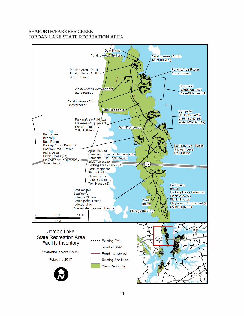
SEAFORTH/PARKERS CREEK
JORDAN LAKE STATE RECREATION AREA

12
VISTA POINT
JORDAN LAKE STATE RECREATION AREA

13
POPLAR POINT AND VISITOR CENTER
JORDAN LAKE STATE RECREATION AREA

14
TRAIL INVENTORY
JORDAN LAKE STATE RECREATON AREA
Trail Inventory Hiking Crosswinds Trail 1.50
Ebenezer Church Trail 1.00
Old Oak Trail 1.00
Connector Trail at Ebenezer Church 0.50
Ebenezer Church Trail 1.00
New Hope Overlook Trail 5.40
Children’s Nature Trail at Parkers Creek 2.25
Connector Trail at Parkers Creek 1.50
Parkers Creek Trail 2.25
Poplar Point Campground Trail 2.04
Jordan Lake Track Trail/Seaforth Pond Trail 1.55
Vista Point Blue Trail 1.23
Vista Point Red Trail 3.00
Jordan Lake SRA Total (miles) 24.22
TRAILS:
CROSSWINDS
Crosswinds Campground: is an easy 1.50-mile trail begins at the boat ramp parking lot and
ends near campsite C1. The trail connects the boat ramp to each camping loop. Hikers can see a
wide variety of native spring wildflowers including Trout Lily and Bigleaf Snowbell.
Crosswinds Campground is for registered campers only.
EBENEZER CHURCH AREA
Ebenezer Church Trail: is an easy 1.00-mile loop trail that passes the site of the historic
Ebenezer Church. An interpretive display marks the location. Parts of the path follow an
abandoned roadbed and traverse a large farm pond. The trailhead is located on the southeast
corner of the beach parking lot.
Old Oak Trail is an easy 1-mile loop trail that begins at the parking lot in Ebenezer Picnic Area
A. This trail can be cut to one half mile by taking the shortcut loop, making this a great trail for
small children. Hikers will see large hollow oaks, two ponds, fence rows and of the farm
ruminants that used to fill the area.
Connector Trail at Ebenezer Church: is a half-mile Connecting Trail at Ebenezer area which
begins at Picnic “Area A” parking lot and connects to the beach parking lot. This trail is an
alternative route to connect to Ebenezer Church.

15
NEW HOPE
New Hope Trail: New Hope Trail is a strenuous hike which begins near the bathrooms at the
boat ramp. The red loop is 5.40 miles and the blue loop is 2.70 miles long. This is the most
challenging trail with several steep hills. Hikers will enjoy views of the lake, mature hardwood
forests, groves of mountain laurel, lush creek crossings and a variety of wildflowers and ferns.
PARKERS CREEK
Children’s Nature Trail at Parkers Creek: is a 2.25-mile loop trail that begins at Picnic
Shelter #3. Hikers will enjoy a long boardwalk, an old farm pond, and see old tobacco rows.
Connector Trail at Parkers Creek at Parkers Creek: is 1.50 miles and connects each camping
loop to the swimming beach. Hikers can see signs of old home sites, including rock foundations,
farm fencing and ornamental plants.
Parkers Creek Trail: is a 2.25 miles and connects portions of Parkers Creek campground.
POPLAR POINT
Poplar Point Campground Trail This easy 2.00-mile trail winds its way from loop B to loop J
and can be accessed from each camping loop. Hikers can see flowering trees such as: Fringe tree,
Magnolia, Sourwood, Dogwood and Witch Hazel. Poplar Point Campground is for registered
campers only.
SEAFORTH
Jordan Lake Track Trail /Seaforth Pond Trail: The Pond Trail is an easy 1.55-mile trail. The
path is nearly a loop; it begins at the display case on the western side of the beach parking lot and
ends near Picnic Shelter #9. Hikers will enjoy views of the lake while walking through loblolly
pine forests, hardwood forests, an old field, and past three ponds. A long boardwalk traverses a
wetland area with buttonbush, black needle rush and other water-loving vegetation.
VISTA POINT
Vista Point Blue Trail is a 1.23-mile loop trail that begins near the entrance gate. Hikers will
see an old tobacco barn. Summer hikers can look for red Cardinal flower in the wetland area near
the boardwalk.
Vista Point Red Trail: is an easy 3.00-mile hike that begins near the shower house. It is nearly a
loop trail, but requires walking along the park road for about 100 yards to end up back at the
shower house. Hikers can see pine and mixed hardwood forests. American Holly trees, and
golden Bur Marigolds.

16
TRAILHEAD SYSTEM
JORDAN LAKE STATE RECREATION AREA

17
TRAIL INVENTORY - CROSSWINDS CAMPGROUND
JORDAN LAKE RECREATIONAL AREA

18
TRAIL INVENTORY - EBENEZER CHURCH
JORDAN LAKE RECREATIONAL AREA

19
TRAIL INVENTORY - NEW HOPE OVERLOOK
JORDAN LAKE STATE RECREATION AREA

20
TRAIL INVENTORY - PARKERS CREEK TRAIL /CHILDRENS TRAIL
JORDAN LAKE STATE RECREATION AREA

21
TRAIL INVENTORY POPLAR POINT
JORDAN LAKE STATE RECREATION AREA

22
TRAIL INVENTORY - SEAFORTH TRAIL
JORDAN LAKE STATE RECREATION AREA

23
TRAIL INVENTORY VISTA POINT
JORDAN LAKE STATE RECREATION AREA

24
IV. PLANNING

25
LAND PROTECTION PLAN –NO CRITICAL ACRES NOTED
JORDAN LAKE STATE RECREATION AREA
NEW HOPE
GAMELANDS
JORDAN LAKE
EDUCATIONAL
STATE FOREST

26
PROJECT EVALUATION PROGRAM LIST
JORDAN LAKE STATE RECREATION AREA
Project Project Title Cost
1 Campsite Improvements (Electric) $5,885,703
2 Wastewater System Improvements $2,437,000
3 Swim Beach Improvements $842,059
4 Park Wide Restroom Building and Showerhouse
Improvements
$1,235,504
5 Road and Parking Improvements $2,898,904
6 Fee Station Access Lane Improvements
$271,723
7 Interpretive Trail $221,403
8 Parkers Creek Campground Improvements
AATATATATALTERNA ALALTERNATIVE
$2,637,968
9 Maintenance Area and Warehouse Improvements $1,654,864
TOTAL $18,085,128
** Estimated protect cost does not include contingencies, design fee, nor escalation.
1. Campsite Improvements (Electric)
The existing electric service to 474 campsites at Jordan Lake State Recreation Area does
not meet the needs of larger recreational vehicles and trailer campers that use these
campgrounds. Circuit breakers trip due to overloads, which creates a potential safety and
fire hazard. Electric service improvements will require a complete replacement of the
electrical system to include: a power panel at each site with an electrical service panel for
up to 12 sites including wire, and pedestal and meter for a group of sites.
This project includes upgrading all existing campsites that are presently served by
electricity to 50-amp service (upgraded from existing 30-amp). This improvement
includes all existing sites with electric service at: Loops C and E at Poplar Point (sites 58
and 109); Area B and C at Crosswinds Campground (sites 68 and 61); the 55-site
recreational vehicle group campground at Vista Point; and Loops 1-4 at Parkers Creek
(sites 26, 17, 27, 53 sites, respectively).
Future campground improvement projects should evaluate the feasibility of adding sewer
and water to electrical sites.
2. Wastewater System Improvements Much of the sewer system is aged and deteriorating (built in 1980). This project provides
upgrades to the sewer systems for the Poplar Point (which serves the administrative area,
Ebenezer Church, Crosswind Marina, Crosswind Campground, White Oak, and the
nearby Chatham County water treatment plant); Parkers Creek; Vista Point; and Seaforth.
The Poplar Point system will also be improved with the following: area lights and a
perimeter of 6-ft. tall chain link fencing will be installed around the two main pump
stations; two- 243-gpm irrigation pumps will be replaced and the spray field will be
renovated with PVC piping, spray heads and valves.

27
The Parkers Creek system will also be enhanced by: replacing the PVC piping, spray
heads, valves, and irrigation pumps for the spray field; adding an aeration pump for the
lagoon; and adding a proposed spray field to improve the irrigation performance.
The Vista Point system will also be improved by replacing irrigation piping underground
to meet current standards.
The Seaforth system will be improved with repair of spray field of piping, spray heads,
valves, and related equipment to meet construction standards.
3. Swim Beach Improvements Erosion and current continually pushes sand away from the swim areas. Scope of work
includes: remove sections of concrete sidewalk at Ebenezer Church, grading, aeration,
drainage, trench drains, seeding, swale and install concrete sidewalks.
Occasional replenishment is required to keep sand at the swim beaches. This project will
add an adequate amount of sand to the swim beaches at Ebenezer Church, Poplar Point,
and Vista Point as needed.
This project also includes additional improvements to the Ebenezer Church recreation
area. The existing four-table picnic shelter at the swim beach will be expanded to an
eight (8) -universal accessible table shelter to help meet the demand for covered
picnicking opportunities at the beach. Approximately 100 native shade trees will be
planted to provide a long-term, sustainable solution for soil stabilization and additional
shade for park visitors. Contractor will mark existing utilities prior to installation.
Ebenezer Church is regularly used by professional and amateur astronomers from the
Morehead Planetarium and the Chapel Hill Astronomical and Observation Society for
star gazing programs. Representatives from these astronomy groups should be consulted
regarding the location of the tree planting to minimize viewing obstructions.
4. Park Wide Restroom Building and Shower house Improvements Twelve (12) of the shower houses and restroom buildings at Parkers Creek and Vista
Point were not constructed with covered areas over the entrances and their rooflines do
not extend beyond the exterior building. This sub-standard design accelerates exterior
water damage to the structures and requires frequent maintenance to replace siding.
Some of these restroom facilities have rain gutters to control storm drainage, while others
do not.
This project will extend the roofline overhang of the 12 restroom facilities with standard
building practices similar to the new restroom facilities at other recreational areas.
Several shower houses and toilet buildings will be upgraded with solar tubes for natural
lighting and retrofitted with exhaust systems to improve air flow and reduce moisture to
current sustainable building standards.
28
5. Road and Parking Improvements The project involves extensive road improvements throughout Jordan Lake State
Recreation Area. All park roads and parking areas at Poplar Point, Seaforth, and
Ebenezer Church will be patched, sealed, and re-striped to current standards. The waste
water treatment plant maintenance road at Poplar Point will be stabilized with min 6”
stone and paved with 1½-inch plant mix and 2 feet wide road shoulders will be re
graded, seeded and stabilized. The dump station road and wastewater treatment
maintenance road at Parkers Creek will be patched and cape sealed. The existing canoe
access road at Robeson Creek will be paved and the boat launch parking lot will be sealed
and painting with standard traffic markings. At New Hope Overlook, the side entrance
road and the boat launch parking lot will be patched, sealed, and standard traffic
markings. At the administrative area, the entrance road, boat ramp road, and ranger
residence road will be patched, cape sealed and standard traffic markings. Additionally,
the maintenance area parking lot at the administrative area will be patched and cape
sealed.
6. Fee Station Access Lane Improvements
This project will improve the traffic flow around the existing fee stations located at
Ebenezer Church, and Parkers Creek to prevent traffic backing up onto roads outside of
the park during times of peak visitation. Each of the fee stations at the three recreation
areas will be improved with the following: widening of traffic lanes; providing additional
traffic lanes to allow fees to be collected on both sides of the fee stations; signage; utility
relocation; and site grading, drainage improvements, 5 overflow parking spaces and
paving as needed.
7. Interpretive Trail
This project includes the construction of a universal interpretive trail near the visitor
center. Scope of work includes: 3,000 linear feet hiking trail (0.57 mile) with an
approximate 1,500-square foot boardwalk for interpretive programs. Directional and
educational signage will also be installed.
8. Parkers Creek Campground Improvements
Parkers Creek is one of the oldest recreation areas at Jordan Lake, constructed in 1986.
The campgrounds are in poor condition and in need of major renovations.
This project consists of general improvements to the Parkers Creek recreation area.
Approximately 80 percent of the tent- trailer campsites (205 sites) and all six group
campsites in this recreation area require extensive improvements including: timbers,
impact pads, grills, light holders, tent pads, screening, picnic tables, trash cans, site
signage, and grading. The boat trailer parking area will be expanded to accommodate 10
additional vehicles with boat trailers. This expansion of the boat trailer parking area is
not in conflict with the recommendations of the year 2000 boating study, because this
parking expansion will only accommodate those visitors who would normally park their
boat trailer at their campsite.

29
The group camp parking area at Parkers Creek is undersized and is often at capacity
during the peak use season. Approximate 3.0 acres nearby will be cleared, graded and
seeded as a grassed overflow parking area to alleviate parking congestion in the group
camp area.
Additionally, the basketball court area will be renovated by resurfacing and stripping.
Site furnishings include: two (2) 50” high standard basketball goals.
9. Maintenance Area and Warehouse Improvements
The maintenance area for Jordan Lake State Recreation Area will be expanded for
storage and enclosed work space. The auto shop building will be expanded by
approximately 825 square foot and an additional 3,720 square foot vehicle storage
building will be constructed behind the existing vehicle storage building. Utilities and
fencing will be relocated to accommodate this expansion. Two 1,000-gallon fuel storage
tanks will be added to supplement the existing fuel storage capacity.
The warehouse is adjacent to the Jordan Lake State Recreation Area maintenance area.
The warehouse area consists of a large paved yard with a 7,500 square foot main
warehouse with office, a 4,300 – square foot warehouse storage building, and a 130 -
square foot ammunition storage building. This project will expand the main warehouse
building by 7,000 square foot and expand the ammunition storage building by 133
square foot.

30
PROJECT #3: SWIM BEACH IMPROVEMENTS
JORDAN LAKE STATE RECREATION AREA
REMOVE EXISTING
SIDEWALKS AND INSTALL
PROPOSED SIDEWALK.
CLEAN OUT EXISTING
GRATES AND ENSURE
POSITIVE DRAINAGE

31
PROJECT #3: SWIM BEACH IMPROVEMENTS AND FISHING PIER AT VISTA POINT
JORDAN LAKE STATE RECREATION AREA

32
PROJECT #6: FEE STATION ACCESS LANE IMPROVEMENTS
JORDAN LAKE STATE RECREATION AREA

33
PROJECT #7: FEE STATION ACCESS LANE IMPROVEMENTS AT PARKERS CREEK
JORDAN LAKE STATE RECREATION AREA

34
PROJECT#8: PARKERS CREEK CAMPGROUND IMPROVEMENTS
JORDAN LAKE STATE RECREATION AREA
EXISTING
COURTESY
DOCK

35
PROJECT #9: MAINTENANCE AREA AND WAREHOUSE IMPROVEMENTS
JORDAN LAKE STATE RECREATION AREA
Existing Courtesy Docks
PROPOSED AMMUNITION
STORAGE BUILDING
AND SECURITY FENCING

36
PARK MAP
JORDAN LAKE STATE RECREATION AREA