job tracking for arcgis workflow management solution · an esri ® white paper • december 2007...
TRANSCRIPT

An ESRI ® White Paper • December 2007
Job Tracking for ArcGIS®
Workflow Management Solution
ESRI 380 New York St., Redlands, CA 92373-8100 USA TEL 909-793-2853 • FAX 909-793-5953 • E-MAIL [email protected] • WEB www.esri.com
Copyright © 2007 ESRI All rights reserved. Printed in the United States of America. The information contained in this document is the exclusive property of ESRI. This work is protected under United States copyright law and other international copyright treaties and conventions. No part of this work may be reproduced or transmitted in any form or by any means, electronic or mechanical, including photocopying and recording, or by any information storage or retrieval system, except as expressly permitted in writing by ESRI. All requests should be sent to Attention: Contracts and Legal Services Manager, ESRI, 380 New York Street, Redlands, CA 92373-8100 USA. The information contained in this document is subject to change without notice. ESRI, the ESRI globe logo, www.esri.com, @esri.com, ArcGIS, JTX, ArcMap, ArcCatalog, ArcEditor, ArcInfo, ArcView, and ArcObjects are trademarks, registered trademarks, or service marks of ESRI in the United States, the European Community, or certain other jurisdictions. Other companies and products mentioned herein may be trademarks or registered trademarks of their respective trademark owners.
J-9005
ESRI White Paper i www.esri.com/jobtracking
Job Tracking for ArcGIS Workflow Management Solution
An ESRI White Paper Contents Page Introduction ........................................................................................... 1 Key Concepts ........................................................................................ 2
Job Management ............................................................................. 2 Work Initiation .......................................................................... 2 Job Documentation ................................................................... 2 Area of Interest ......................................................................... 3 History/Activity Log ................................................................. 3 Notification ............................................................................... 3
Workflow Management .................................................................. 3 Geodata Management ..................................................................... 4
Simplified Version Management .............................................. 5 Historical Tracking of Data Edits ............................................. 5
User Management and Security ...................................................... 6 Anatomy of a Job .................................................................................. 7
What Is a Job? ................................................................................. 7 Job Types ........................................................................................ 8 Job Information ............................................................................... 8
Standard Properties ................................................................... 8 Custom/Extended Properties .................................................... 8 Tracking and Documentation ................................................... 9
Assignment ..................................................................................... 9 Area of Interest ............................................................................... 9 Workflow ........................................................................................ 9 Version ............................................................................................ 10 Target Geospatial Database ............................................................ 10 Map Document ............................................................................... 10
Job Tracking for ArcGIS Workflow Management Solution
J-9005
December 2007 ii www.esri.com/jobtracking
Contents Page Framework ............................................................................................ 10
JTX Repository ............................................................................... 10 JTX Configuration .......................................................................... 11 JTX for the Desktop ........................................................................ 11
JTX Application ........................................................................ 11 ArcGIS Tools ............................................................................ 12
JTX Tools for ArcMap........................................................ 12 JTX Tools for ArcCatalog .................................................. 13
JTX Application Programming Interface ................................. 13 Job Tracking for ArcGIS Server ............................................... 13 Use Cases .................................................................................. 14 JTX Web Services..................................................................... 14 JTX Web Application ............................................................... 14
Working with JTX ................................................................................ 14 Overview of the JTX Application ................................................... 15 Sample Workflow for Updating Parcel Features in a
GIS Database .............................................................................. 15 Create a Job ............................................................................... 16 Document the Job ..................................................................... 16
Edit Job Properties .............................................................. 17 Add File Attachment .......................................................... 17
Locate the Job ........................................................................... 19 Assign the Job ........................................................................... 19 Take Up the Job and Begin Working ....................................... 20 Work the Job ............................................................................. 20
Step 1: Gather Information from Application ..................... 21 Step 2: Check for Imagery .................................................. 22 Step 3: Create Version ........................................................ 22 Step 4: Edit Data ................................................................. 23 Step 5: QC ........................................................................... 24
Using the JTX Web Application ............................................... 24 Viewing Jobs ...................................................................... 25 Inspecting Details of the Job .............................................. 25
Summary ............................................................................................... 27
J-9005
ESRI White Paper www.esri.com/jobtracking
Job Tracking for ArcGIS Workflow Management Solution
Introduction Geographic information system (GIS) implementations, both large and small, often involve many people with different roles and skill sets; multiple tasks with detailed workflows; and a variety of datasets, software, and tools. It is critical for project success that this information (processes, staff allocation, progress, and status) be tracked while ensuring the work is completed in the most efficient and timely manner possible. Being able to facilitate and monitor these efforts in a way that does not encumber the business process and is tightly integrated with the software has traditionally been the challenge when it comes to job tracking and workflow management. By looking at an example of a typical GIS project workflow, one can get a better understanding of the business challenges that ESRI® Job Tracking for ArcGIS® (JTXTM) directly addresses and the job tracking and workflow management functionality such projects commonly require. For example, a central organization hosts and maintains a detailed database of the coastal regions of northern California. New source information (e.g., satellite imagery and field reports) becomes available for a particular geographic area. This new imagery shows the latest conditions of the shoreline after a large storm. The central database contains all thematic layers for the region (e.g., buildings, physical features, and roads and other infrastructure). This data now needs to be updated per this new source information to produce up-to-date maps and services of the area. Typically a manager or supervisor will divide this work up by geographic areas (e.g., half-degree grid cells or discrete georeferenced image extents) and distribute the work among production staff. Editing staff will need to apply the changes to the data. Quality control (QC) staff will need to review these edits, identify any errors, and send them back to editors for correction. Once errors have been fixed and verified, the data is ready to be integrated into the master database. This process could take several days, weeks, or months and could involve editing the same layers, sometimes in the same area being worked on by other staff. Therefore, long transactions must be leveraged, providing the ability to obtain a "snapshot" of the data to work with that is only integrated into the master database when all changes are complete. The manager will want to keep track of those who are working in each area; on which unit of work; how far along they are in their edits; any problems or issues encountered; how many QC cycles are necessary; and, perhaps most important, when the work is completed. Job Tracking for ArcGIS is a solution to manage enterprise geospatial workflows. It simplifies many aspects of job management and tracking. The workflow management functionality guides users through the necessary GIS and non-GIS tasks required to complete the entire business process. Job Tracking for ArcGIS provides tools for allocating resources and tracking the status and progress of jobs. A detailed history of work activity is automatically recorded to give managers and supervisors a play-by-play report of how the job was completed. This information can be supplemented with comments, notes, supporting documents, and notifications to capture even richer job documentation and communication in a single centralized repository. Job Tracking for
Job Tracking for ArcGIS Workflow Management Solution
J-9005
December 2007 2 www.esri.com/jobtracking
ArcGIS handles complex geodatabase tasks behind the scenes by creating and managing versions. And a comprehensive framework is provided to support historical tracking of feature edits. In addition, developers can utilize the JTX application programming interface (API) and Web services to leverage JTX functionality in new applications or integrate that functionality into existing solutions or enterprise systems. Job Tracking for ArcGIS is available for both ArcGIS Desktop and ArcGIS Server, allowing an organization to implement JTX in both local and distributed environments. This paper introduces key features of Job Tracking for ArcGIS. It discusses the terms job, tracking, and workflow management in the context of JTX and how they map functionality within the system. It presents the JTX framework, explores key integration points with ArcGIS, and touches on topics of configuration and customization. An example workflow scenario illustrates the main features of the software and ties together key concepts covered in this paper. For a complete discussion of how to configure and use Job Tracking for ArcGIS, refer to the documentation and help system provided with the software.
Key Concepts The following section covers several important aspects of the JTX software, each of which addresses some of the business challenges outlined above. Discussion of these key concepts will begin to introduce some important features and functions of the system. These will also be covered in further detail in later sections.
Job Management
Job Tracking for ArcGIS helps authorized users create units of work in an efficient, standardized manner and distribute them to appropriate staff across the organization. The software provides the necessary tools to obtain quick updates of who is working on what as well as monitor the progress of the work by user or by unit of work. There are robust search and query tools to help users quickly find the jobs they are working on or jobs based on specific criteria (e.g., high-priority jobs, overdue jobs, or work assigned to a particular user or geographic area).
Work Initiation
There are several ways jobs can be initiated in the system. Each job can be created one at a time or in batches. When creating a job, the user can optionally specify the number of jobs to create. Each job will then get the same initial properties, with the exception of job identifier. Jobs can also be created from geographic features. For example, if the GIS database contained a layer of search grids, the creator of jobs could specify that layer or select several search grids from a map, and the system will create a job for each geographic feature in the set and use the feature's geometry as the geographic area of interest for the job. More details on the area of interest of a job are covered in a later section.
Job Documentation Jobs can be detailed with descriptive information and instructions. Standard properties of the job handle basic descriptive information common to any unit of work (type, priority, due date, description). Custom properties can be configured to capture additional business information specific to the organization, project, or type of job (e.g., parcel number, department code, market territory, wire center). These are properties JTX simply cannot anticipate or provide by default, and these may differ for each type of job that could be created in the system. Configuration tools make it easy to add these additional properties to the job tracking system and have them presented seamlessly in the applications, queries, and reports. Documents can be attached to the job to link supporting files to the work being performed. These can be source files, scanned images, legal documents, forms to be manually filled out by the user, and more. The JTX system can store these in the centralized job repository, along with the job information, or simply as a link to a file in a known file system location.
Job Tracking for ArcGIS Workflow Management Solution
J-9005
ESRI White Paper 3 www.esri.com/jobtracking
Area of Interest Another powerful aspect of job management is the use of a geographic area to delineate the working extent of a job. The area of interest (AOI) tracks where within the geospatial database work is, and has been, performed. This area could also represent where in the real world some activity is occurring on the ground (survey, construction, search and rescue operations). This allows users to determine the status and distribution of those jobs and their spatial relationship to one another or other geographic data with a quick visual inspection on a map.
History/Activity Log Job Tracking for ArcGIS provides the ability to track the user's interaction with a job throughout its existence. Any action that is performed on the job (e.g., modifying any of the job's properties, changing the state of the job, executing a step) is time stamped and logged. This historical log can be supplemented by user comments (e.g., issues, clarifications, decisions). This allows users of the system to see a successive listing of what has been done to the job since its creation and allows tracking back to a particular period of time to help identify problems or justify certain activity.
Notification Users can be automatically notified via e-mail when certain event actions are performed on the job. You may want specific staff or other stakeholders of the work being performed to be notified when jobs are created, completed, modified, reassigned, and more. This can be useful for staff that may not get work assigned to them each day or may be working on a job for an extended period of time and for stakeholders of the work who do not directly interact with the JTX system.
Workflow Management
One of the primary goals of Job Tracking for ArcGIS is to help organizations perform their jobs more efficiently and improve overall productivity. Possibly the most important component of JTX is its powerful workflow engine. This is the key to effectively modeling, standardizing, and even streamlining the steps and tasks required to carry out the work. Easy-to-use applications and tools provide administrators, managers, and business developers with a way to author and publish standardized workflows, leveraging best practices and procedures while providing a consistent and traceable process for users to follow. In JTX, each unit of work, or job, has an associated workflow that represents the operational aspect of the work to be performed. Workflow can be defined as the movement of information and/or tasks through an ordered work process. The JTX application presents to the end user the set of steps, rules, transitions, and actors involved in completing that work process. This takes the guesswork out of what the job entails, provides an automatic overview of the tasks ahead, and ensures no step is missed. It keeps track of completed tasks in the workflow; this allows progress to be quickly evaluated and can be useful for analysts who have several jobs assigned to them and frequently switch between jobs over the duration of their workday. Workflows are composed of steps and paths. A step is an individual task to be completed by a user. A path is a conditional route linking steps. In other words, paths define what is done and steps define how it is done. A complete workflow is a network of steps joined by paths. By default, a step in the workflow consists of a description of some task that needs to be performed by the user at that particular point in the overall process. It simply serves as an indicator to the user of what needs to be done. The user performs the task, then indicates through the JTX application that the task has been completed. When it's checked off, the workflow advances to the next step.
Job Tracking for ArcGIS Workflow Management Solution
J-9005
December 2007 4 www.esri.com/jobtracking
In addition to this, steps can be configured with behavior; that is, the workflow can be set up to automate certain activities for the user. With the click of a button, JTX can automatically launch the application or program needed to perform, for example, the task of running a script or batch file, running a geoprocessing tool, calling a Web service, or running custom executables or components. This capability can greatly improve efficiency by reducing the manual user interaction required to perform a standard, repeatable operation. An existing ESRI or non-ESRI executable, application, or program can be plugged into the workflow. Additionally, developers can write their own behavior into a component that can be easily configured into the workflow and executed by JTX when that step is reached. An argument string can be configured for passing information to the program or component being run. The JTX software provides several common and ready-to-use steps to plug into workflows. These include launching ArcMapTM with preconfigured layers, connections, cartography, and tools; creating a geodatabase version for the job; running a geoprocessing tool; automatically creating new jobs of a certain type; and sending an e-mail notification. JTX allows for simple (linear) or advanced workflows to be modeled, depending on the complexity of the business process and the extent to which they need to be tracked. Some workflows may be of a very high level and only track major, key milestones in the job life cycle. Other workflows may be quite detailed, and organizations may wish to track work at a more granular level, documenting decision points and alternate paths taken or providing capabilities for conditional logic or multiple loops/iterations of portions of the workflow, effectively guiding users through a more complex order of operations. Workflows can be configured with tight controls to ensure steps are not skipped or performed out of sequence. It is also possible to model relationships and dependencies between jobs that would affect how and in which order each unit of work is performed. For example, a manager may want to create a set of jobs but knows that work on some jobs cannot begin until other jobs have been completed or have at least reached a certain stage in their respective workflows. A job to produce an updated map of a flood area could not be started until the work is completed that has collected the latest flood boundaries from new imagery. The manager may want to create, schedule, and allocate all the jobs at once rather than waiting for the editing jobs to be completed before creating the cartographic jobs. By creating the cartographic job, then putting a dependency on the related editing job, the cartographic job is essentially frozen in the system until the status of the editing job reaches a completed stage. At that point, the cartographic job becomes active and can be worked on. A job can also be suspended at any time. For example, if there is a reason a job needs to be put on hold for a period of time (system upgrade, budgetary issues), users granted this privilege can put the job on hold, citing a reason and detailed description. The job can be queried for and viewed but cannot be actively worked on again until someone with the privilege to do so removes the hold. For those using the job history to mine productivity statistics or trends, the time the job was placed on hold can then be subtracted from the overall active period of the job.
Geodata Management
Across the wide range of industries, the work that is performed often involves using, managing, or updating GIS data. Some specific needs and challenges in this area are common across organizations and their business processes. Job Tracking for ArcGIS provides some key features to richen and improve these aspects of geospatial data management using ESRI geodatabase technology.
Job Tracking for ArcGIS Workflow Management Solution
J-9005
ESRI White Paper 5 www.esri.com/jobtracking
Simplified Version Management
A geodatabase version can be created for, and associated with, a job for the duration of that job. Not all jobs require a new version to be created; however, if the GIS data is going to be edited and maintained in a multiuser environment, a version will be required. This allows engineers to take advantage of long transactions to avoid interfering with the work of other users who may be working on the same layers or in the same geographic area. JTX furthers the inherent advantages of versioning by tying a specific version or long transaction to a job and, therefore, to all the information about the work being performed: its descriptive information, user lineage, supporting documents, activity log, and workflow. Managing different versions for each job or for groups of jobs can require a good deal of thought and overhead. Versions will need to be created from the parent lineage that has been determined will best support the data maintenance strategy. Also, GIS analysts performing the edits will need to make sure they are editing the version that has been created for the particular job. To do this, it is often necessary to manage connections for each version a user is working with, which typically would require creating and managing a catalog of connections to the data in ArcCatalogTM. JTX helps simplify this version management for both analysts and administrators alike by providing productivity tools for the creation, management, and targeted editing of a job's version. It allows users to configure, up front, the parent version from which the job versions should be derived. For example, if all jobs should be derived from a staging version rather than the default version, this can be modeled and enforced by JTX. It provides tools for creating the version with a single mouse click. It manages the connection information of each version, which eliminates having to maintain the user's own catalog of connections to each version they are working with. Also, JTX can automate the loading of GIS layers into ArcMap and ensure the user is connected directly to the job version as well as connected as the appropriate database user so RDBMS-level permissions are honored. This reduces common user mistakes such as pointing to the wrong version or accidentally reusing an old connection file. This can reduce many of the extra steps required by the user to create, manage, and switch between versions as they move from one job to another. For a more detailed discussion on versioning and the geodatabase, refer to the online documentation at http://webhelp.esri.com.
Historical Tracking of Data Edits
Job Tracking for ArcGIS delivers rich support for the capture and storage of record-level edits made to data in a geodatabase. JTX uses the term transactions to define this concept. Each edit to a record in the geodatabase, and the information describing that edit, makes up a single transaction. JTX allows tracking of edits made to versioned geodatabase feature classes, annotation classes, attributed relationship classes, and stand-alone tables. JTX allows administrators to configure the specific datasets for which transactions will be captured. The JTX transaction record stores the type of change made to the feature (whether it was added, modified, or deleted) as well as which individual attributes were edited. In the case of spatial edits, the changes to the feature geometry are captured as well. In either case (attribute or a geometry edit or both), the JTX transaction record stores the value of those fields before the edit was made and the values after the edit was made. A date/time stamp, the geodatabase table in which the feature/record resides, the global feature identifier (GFID), the job identifier, and the user are also recorded in addition to the details of the edit. The job ID will link the edit back to the job for which the edits were made. The GFID links transactions back to features in the geodatabase. The transactions
Job Tracking for ArcGIS Workflow Management Solution
J-9005
December 2007 6 www.esri.com/jobtracking
are recorded in an Open Geospatial Consortium, Inc.® (OGC®)-based Extensible Markup Language (XML) format that leverages industry-standard geographic documentation of features. The use of XML provides cross-platform flexibility and also portability of this transactional information. The geodatabase versioning model is the primary mechanism JTX uses to perform detailed tracking of feature edits and historical archiving of those modifications. These edits are ascertained when the job version is reconciled and changes are posted back to the master database. Thus, only permanent edits to the data are captured and recorded rather than intermediate edits that may be discarded over the course of a job or iterative edits that may be part of several operations performed to achieve an end result. JTX provides a tool to perform the logging of transactions during the posting operation rather than the standard Post tool provided in ArcMap. Each geodatabase feature class that is registered with JTX for transactions should contain a field for storing a GFID. This number should be unique across all features in the database, not just within a particular table. JTX does not maintain this GFID but relies heavily on it for recording feature-level transactions and metadata. How that field is maintained is entirely up to the JTX user. A transaction table exists in the JTX system repository for the sole purpose of warehousing transactions, and it is there that the properties and XML of each transaction are stored. It can be queried by GFID, job ID, date range, or other criteria to retrieve transactions, view the details, and display them spatially on a map. JTX also provides tools to determine what edits have been made to a particular feature over time and allows users to see a full record of each individual edit (e.g., who made the edit, what job it was part of, reason for edit) even after the version has been deleted from the geodatabase. The system also allows the user to revert features back to any of the previously stored states if it is determined that an edit was incorrect.
User Management and Security
A very important aspect to any business process is the people who will play a role in the initiation, execution, and management of the work being performed. Understanding how work flows and changes hands across the organization is part of the process of JTX management. User management components enable the work to be allocated and distributed among the different users of the system. It is the way JTX tracks who interacted with the job at any given time for traceability and accountability. JTX also provides capabilities to configure which users have access to the JTX system and what operations each user is allowed to perform. A job can be initiated by a single user and worked through its entirety by that person, or a job could involve many players who need to interact with the job at various stages in the life cycle and even at particular steps in the job workflow. At any given time in the active life cycle of the job, the job is assigned to an individual user of the system. This identifies the user who has access to modify or work on that job. When the job is assigned to an individual user, only that user can interact with that job (e.g., interact with the workflow, update properties, reassign the job), and the activities of that person are logged in the job history. JTX workflows can be configured to automatically assign the job to a user when a specific step in the workflow is reached, saving time and ensuring the work is routed to the right resources. Each user belongs to a user group. Jobs can initially be assigned to a user group rather than to an individual user. Assignment to a user group places the job in a virtual queue. This provides a pool of jobs that users belonging to that user group can pull from when they are ready to begin work on a new job. For example, there are 12 data engineers who
Job Tracking for ArcGIS Workflow Management Solution
J-9005
ESRI White Paper 7 www.esri.com/jobtracking
all have the same editor privileges. The manager can divide a geographic area into chunks by defining a set of jobs and specifying the area of interest for each job. The manager would then assign each job to the editor group. When the users of that user group are finished with their job (or are waiting for another job to be reviewed or approved), they can simply search for the jobs assigned to their group, reassign a job to themselves, and begin working. A job cannot be modified when assigned to a queue. Only when a job is assigned to an individual may it be modified or processed. User groups also define what application privileges users have within the group. An example implementation might have a manager group, a GIS analysts group, a QC group, a data steward group, and so on. Each group would be assigned privileges based on the role it plays in the maintenance and execution of the job. The manager may have the ability to create jobs and close jobs, but an editor or QC user would not. Users can control not only who has access to the JTX system and the work managed therein but also what the user can do in the system. A JTX user can be someone having the highest level of control over the work or someone with very little control. For this reason, and for purposes of enforcing security, JTX must be explicitly told which users have access to the job management system to begin with. Through configuration of the JTX system, it is determined which users can launch the JTX application and begin to interact with the jobs being managed there. By default, JTX will use the registered Windows login to determine the user accessing the application and verify this with the registered set of JTX users configured into the system. JTX can also control users' access to the data itself by ensuring each user is connecting to the database with the correct database login. JTX configuration provides an interface to configure this into the profile of a JTX user. In this manner, different users can have different security policies based on their unique database login. The cornerstone to this security model is the assignment of unique logins for each user in the database. Within the specific database implementation, it is also possible to assign users to database roles, allowing easier management of user privileges. The assignment of security through the database model allows security to be ubiquitous, regardless of the application used to access the database. A user accessing via ArcMap, ArcCatalog, or any other database-accessible application would have the same security model imposed, making a more secure environment.
Anatomy of a Job
What Is a Job? A job is quite simply a unit of work to be performed by one or more people. A job represents the discrete iteration of a predetermined business process, the tasks for which are performed by several people, departments, or contractors. JTX is completely configurable; therefore, what a job means to one organization may vastly differ from that of another. Different users, tasks, data, documentation, applications, and tools may be required for each type of job performed. In addition, the duration of a job may last for months or merely hours. But whatever the job at hand, JTX provides a common framework for modeling, tracking, and storing all these elements and presenting a consistent user experience to orchestrate the entire life cycle of the job. Some examples of a job include the following:
Extract new features from aerial photography. Process a permit for landownership. Perform major road improvement. Manage data input from search and rescue operations.
Job Tracking for ArcGIS Workflow Management Solution
J-9005
December 2007 8 www.esri.com/jobtracking
Update a hydrant at specified coordinates. Create a 1:50,000-scale map. Load and catalog data into a spatial data warehouse. Perform site analysis for store location.
The following sections will describe all the elements that comprise a job in the JTX system.
Job Types As indicated above, it is critical to identify all the different business processes and related information that need to be modeled and tracked in JTX. The crux of configuring Job Tracking for ArcGIS for any implementation is the definition of job types. Consider a job type to be a blueprint or template for the jobs that will be created in the system. A job can be thought of as a living "instance" of a job type. The first thing JTX will ask a user when a new job is being created is what type of job is going to be performed. This determines several primary characteristics of the job including the workflow, descriptive information, and target geospatial database. For example, a job type for creating 1:10,000-scale maps may be defined, which would require a workflow or set of tasks needed to accomplish the creation of that 1:10,000-scale map (e.g., define an area to work in, gather data, create map elements and cartography [such as title, surround elements, and other graphics], verify/QC map against map specification, and print map). This type of job would also require that a standard group of layers be displayed. These layers would contain features that are graphically meaningful at a scale of 1:10,000 (e.g., buildings, residential streets). There may also be documents and descriptive information unique to this work (map series name, requesting party, number of copies, etc.). The characteristics that can be defined for each job type at configuration time are listed below. Each instance of a job would then essentially inherit the same values of these elements when it is created (each of these is discussed in further detail in the following sections):
Workflow Initial values of standard job properties Custom/Extended property fields Initial values of custom/extended properties Map document Standard naming conventions for jobs, map documents, and job versions
Job Information Each job that is created maintains a set of properties that describes the job and tracks the
state of a job at any time in its life span.
Standard Properties Each job maintains a set of properties that describe specifics about the work that is being done. JTX provides a basic set of properties that are generic enough to apply to any unit of work being performed. These are referred to as standard properties, and jobs of all types will host this set of properties. Some require values; others can be optionally populated if applicable to that particular job. These include identifier, name, user/group assignment, description, status (created, in progress, on hold), priority, dates (e.g., due date and completed date), and job version name (if relevant).
Custom/Extended Properties
There may be additional information about the job that needs to be tracked and is not included in the standard set of job properties provided out of the box with JTX. One could simply place these values in the Description field or in the notes for a job, but this
Job Tracking for ArcGIS Workflow Management Solution
J-9005
ESRI White Paper 9 www.esri.com/jobtracking
makes it difficult to control the user input, and those values cannot later be queried or reported on in any standardized fashion. By providing additional properties of the job as standard fields with known data types, those values become a seamless extension to the generic job properties and are presented by the JTX applications in a predictable location and with appropriate controls for entry (e.g., date picker, drop-down lists, numeric entry). Extended properties are configured for each job type, with each type potentially having its own completely different set of fields from other job types.
Tracking and Documentation
As mentioned previously, the user's interaction with the job is automatically logged by the system in what is referred to as the job history. Each action is time stamped, tagged with the user who performed the action (the user currently logged in to the JTX application), the category of action, and a text string describing the action. The types of activities logged include (but are not limited to) job created, job assigned, workflow step completed, and job properties updated. Additional user-specified information or comments can be captured as well. These are also user and time stamped and presented in line with the system-captured information.
Assignment The job will be assigned to an individual JTX user or to a user group, or it will be unassigned. Tools are provided in the application for quick job assignment. User privileges can be configured to control whom users may assign jobs to. Some users may have carte blanche control and can assign any job to any user at any time. Other users may be restricted to assigning only jobs that are currently assigned to that user. They may also be further restricted to only assigning jobs to other users in their group.
Area of Interest The AOI is the geographic extent of a job. This helps serve as a guide to the user indicating where the work is to be performed. It also helps managers and users track when edits are in progress in a particular area of the geodatabase to avoid conflicts and prioritize and coordinate activity between many users and user groups. JTX provides a rich set of tools for defining the area of interest directly from the main application at any time in the life cycle of the job. Users can also define the area of interest at a specific point in the workflow using one of the workflow steps provided in the JTX step library. This enforces the area of interest to be specified at a particular step in the workflow and launches an application that drives the user through a more structured process of defining their area of interest. Using either method, the area of interest can be delineated as a user-specified extent (rectangle or polygon) drawn on a map. It can also be defined by selecting an existing polygon feature (or features) from another dataset. A user can also simply browse to the location of a dataset (e.g., a shapefile, georeferenced imagery, a geodatabase feature class), and JTX will use the extents of that dataset as the area of interest polygon for the job. The area of interest features for all jobs are stored in a special feature class in the database that is maintained by JTX and linked to its job by the job identifier. JTX does not use the area of interest to restrict user activity outside this area. It is simply a geographic reference for the work. However, a system setting can be applied to restrict definition of an area of interest that overlaps that of an existing active job in the system.
Workflow As described in an earlier section, each job type has a workflow associated with it thathas been configured for the type of job. By default, when a job is created, the workflow template is copied from the job type and cannot be changed for a particular job instance. A system setting can be applied to allow the workflow to be modified when the job instance is created, giving the user a chance to add, drop, or reorder steps in the workflow before the job is officially operational. Once the workflow of a job has begun, however, it cannot be modified.
Job Tracking for ArcGIS Workflow Management Solution
J-9005
December 2007 10 www.esri.com/jobtracking
Version A version of the geodatabase can be created and linked to the job for the life of the job. Version names are based on the job ID to easily associate versions in the database with their corresponding jobs in JTX. JTX provides the ability to create this version automatically, without running the ArcCatalog or ArcMap applications.
Target Geospatial Database
JTX is typically used to manage workflows involving some interaction with or access to geospatial data. An organization may have a single geodatabase that houses all its GIS data and tables, or it may have its data distributed across several database instances. A job in JTX can be configured to look after the activities and content of a particular geodatabase. The information about the location of the data and how to connect to it can be associated with the job. This enables certain JTX tools to seamlessly interact with the geospatial database without requiring the user to maintain this information or prompting them for it.
Map Document If the job involves the use of ArcMap for data editing, visualization, analysis, or cartographic finishing, the JTX framework can create and manage an ArcMap document for the job. This simplifies the setup needed to begin working in ArcMap by having the session preloaded with layers, tools, cartography, and document settings that allow a user to quickly begin the operation at hand. When the job type is configured, as mentioned earlier, an ArcMap document (MXD) can be configured with that job type that would serve as the template for any job created of that type. For example, jobs that would require editing of street data may require several transportation and basemap layers to be loaded with cartography and labeling set to easily find and distinguish streets from one another. Users may also want certain snapping options set and any advanced editing tools to be visible. With all this configured ahead of time, when ArcMap is then launched from the JTX application during a particular job workflow, the map document of the job type is copied, associated to the job, and opened for the user to quickly begin their work. This ArcMap document is stored in the job repository and maintained with that job for the lifetime of the job. This is a handy way to create a portable, machine-independent session for ArcMap users. When the user begins or resumes work on a job, using the smart launching capabilities of the JTX workflow engine, its MXD is retrieved from the database and stored locally for that session. When ArcMap is launched, the MXD is automatically loaded into that ArcMap session. Any changes to the MXD are saved and posted back to the database. The name of the MXD is based on the job ID so users can easily associate the MXD with its corresponding job.
Framework Job Tracking for ArcGIS provides local and distributed deployment options for a complete enterprise solution for job tracking and workflow management. The two products are JTX for ArcGIS Desktop and the Job Tracking for ArcGIS Server extension. Both products require access to the JTX repository, the geodatabase housing all the information and rules that drive the applications. And each product provides rich configuration tools and developer offerings for complete customization of any JTX implementation.
JTX Repository Job Tracking for ArcGIS is a richly configurable, database-driven application. At the heart of every JTX implementation, either desktop or server, is a set of database tables that reside in a geodatabase. These tables store all configurable information: job types, workflows, users, privileges, and all other elements. These are the values and behavior presented to the user by the JTX applications and interfaces. Once an organization goes live with its JTX configuration, these tables also store the specification and details of
Job Tracking for ArcGIS Workflow Management Solution
J-9005
ESRI White Paper 11 www.esri.com/jobtracking
each job that is created in the system. Feature-level history (transactions) is stored here as well. The JTX repository can be implemented on top of any RDBMS supported by ESRI's geodatabase technology. One JTX repository can serve as the single, centralized repository for both JTX desktop and server applications, supporting a single enterprise solution involving local and distributed deployment of JTX applications.
JTX Configuration Because there are so many elements that can be configured for a JTX implementation, the software provides a user-friendly application and tools for managing the contents of the JTX administration database. A full suite of tools is provided for creating, updating, deleting, and cross-referencing information for these tables, effectively customizing JTX to meet the specific needs of an organization. It is these tools that an administrator of the system would use to bring new workflows online, augment existing workflows or job property fields, register or drop users as staff come and go, and more. Active jobs in the system and their related information can also be managed with more specialized access than the standard user application provides. The Configuration Manager provides tools for reassigning several jobs at once to a different user or user group (regardless of to whom it is currently assigned). Jobs can be deleted from the system entirely, something that is not exposed through main JTX applications. Certain job elements can even be selectively deleted, such as the geodatabase version associated with the job or the job's MXD, while preserving the job itself. The Configuration Manager also provides a mechanism for transporting a configuration setup from one JTX database to another if a project calls for multiple databases with essentially the same users, job types, and so forth. Any JTX administration database can be exported to a JTX Configuration Exchange XML file. This file can then be imported into any other geodatabase, effectively copying an entire JTX configuration to another location. It is important to mention that the Configuration Manager is intended for use by a manager or the administrator of the JTX system and typically would not be accessible to standard users of the system.
JTX for the Desktop Job Tracking for ArcGIS extends ArcGIS for the desktop to provide job tracking and workflow management functionality to any machine deployed with ArcEditorTM or ArcInfo® (the ArcView® license level is not supported). JTX for the desktop consists of a stand-alone application that serves as the main user interface for accessing all the functionality of JTX. There are also tools integrated into ArcMap and ArcCatalog, ESRI's flagship editing, mapping, analysis, and data management applications. JTX desktop applications and tools sit on top of a rich application programming interface and business objects that provide programmatic access to JTX functionality to any developer.
JTX Application Job Tracking for ArcGIS provides a stand-alone application that exposes all functionality for managing jobs and workflows to ArcGIS Desktop users. From this comprehensive, singular dashboard, jobs can be created, assigned, queried, inventoried, and worked. The target users of this application include the entire roster of people and roles that have a hand in some aspect of the job life cycle. This is the dashboard for managers and supervisors to initiate jobs in the system, allocate resources to that work, and obtain status and evaluate the progress and workload at any given time. This is also the entry point for the user to which the job will be assigned. Users will interact with the JTX application to search for their jobs, if there are any jobs in their work queue; pick up jobs and begin
Job Tracking for ArcGIS Workflow Management Solution
J-9005
December 2007 12 www.esri.com/jobtracking
working; iterate through the tasks in the workflow; update the status of the work; and document their progress and provide corollary information along the way. As described in the User Management and Security section, user privileges control what tools and functionality the user will have access to when the application is launched on their machine. Some tools and tabs may be disabled if the user has not been granted the privilege to perform that function (e.g., creating a job, modifying the properties of a job, assigning their job to another resource).
ArcGIS Tools Though much of the interaction with a JTX implementation happens in the JTX application, it may be important for a user to have direct access to job information from within ArcMap (without having to go back to the JTX application itself). Some tools provide other JTX functionality, such as storage and management of JTX transactions, detailed in earlier sections.
JTX Tools for ArcMap
A JTX toolbar hosts the specific JTX ArcMap commands detailed below.
Add Data From Job Version—Allows users to add data to the ArcMap table of contents from the version of the current job. It is a handy shortcut that eliminates having to specify or maintain connection information for each of the jobs the user is working on.
Zoom To Job Area Of Interest—A spatial bookmark to zoom users to the job's
area of interest.
Show Job Properties—A dockable window displaying the properties of the job.
Show Job History—A dockable window that displays the job activity log and the control for user-specified comments to be added.
Show Job Attachments—A dockable window listing the job's related documents,
with the ability to open any document directly from ArcMap.
ArcMap Reconcile—The default Reconcile button that comes out of the box with ArcMap. This button is exposed from the JTX toolbar for convenience because it is used in conjunction with the JTX Post command (versions must be reconciled and any conflicts resolved prior to being posted).
JTX Post—Users can post their edits at any time throughout the life span of a job
using the custom JTX Post command. The user experience is the same as it would be using the out-of-the-box ArcMap Post command, but this command will not only post changes to the parent version, it will also log JTX transactions.
Feature History Inspector Tool—A tool that allows the user to interactively
identify a feature on the map and view the lineage of changes for that feature. When a feature is selected on the map, the tool interrogates the JTX Transaction table and retrieves all the transactions having the same global identifier as the feature identified. It utilizes a tree-view structure to allow the user to step back through each of the past feature states. If a geometry change has occurred, the user will be able to see the past geometries overlaid on their ArcMap canvas for visual inspection.
Job Tracking for ArcGIS Workflow Management Solution
J-9005
ESRI White Paper 13 www.esri.com/jobtracking
Job Transaction Loader—A command that adds a graphic layer to the map displaying all transactions that meet some user-specified criteria. This can be useful to get an overall assessment of the quantity of edits made in a job, the type of edits made (e.g., adds, modifies, deletes), in which area those edits were concentrated, and so forth.
Transaction Inspector Tool—A tool that allows the user to interactively identify a
graphic that has been placed on the map by the Job Transaction Loader tool that lists the details of the transaction itself. This is especially useful to see details of a deletion when the underlying feature no longer exists in the data and cannot be interrogated using the Feature History Inspector tool.
Load Changes—Will add a graphic layer to the map displaying all the feature
modifications made in the current edit session that have not yet been posted. This is a way to view edits before they are posted.
Most of these tools will only be available in a job-aware ArcMap session, that is, an ArcMap session that has been launched using the JTX application-provided Launch ArcMap step configured into the job's workflow. Since many of these tools need to know what the current job is to perform their respective function, using this step to initiate an ArcMap session is a requirement to using these tools. See the Workflow Management section for more details.
JTX Tools for ArcCatalog
A new connection node in the Catalog tree provides the ability to configure JTX database connection information for a JTX repository (or repositories) and allows registration of layers with JTX for capture of transactions.
JTX Application Programming
Interface
The JTX API is the development platform for Job Tracking for ArcGIS. The JTX business objects expose the full range of functionality necessary for configuring, creating, managing, and working with jobs. The JTX objects were built using Microsoft's Component Object Model (COM) technology and extend ESRI's ArcObjectsTM framework. The core ArcObjects geodatabase API is used to perform all database access functions to the JTX system tables for platform independence and legacy compliance with database access protocols. This API was used to write the JTX application that is provided out of the box. Therefore, it allows developers to write an entirely new application to manage jobs with a different look and feel than the JTX application. This could provide all JTX functionality or simply a subset of JTX capabilities and could fuse this functionality with other business logic or information. It may also be necessary to provide access to JTX jobs and information or workflow management capability from other custom or third-party applications and controls. The rich API allows developers to embed JTX functionality into existing applications or system components.
Job Tracking for ArcGIS Server
With the introduction of the Job Tracking for ArcGIS Server extension, organizations can leverage their investment in JTX across the organization to non-GIS users and systems that have a stake in the work or direct players in the business processes modeled and managed by JTX. An organization can expose heavyweight job tracking and workflow management capabilities through controlled, lightweight applications targeted at specific users of the system, so the benefits of any JTX implementation can be shared with a greater number of people at a lower cost. Job Tracking for ArcGIS Server can complement the existing JTX for ArcGIS Desktop implementations or can be deployed in
Job Tracking for ArcGIS Workflow Management Solution
J-9005
December 2007 14 www.esri.com/jobtracking
a purely distributed environment. Some standard use cases for Job Tracking for ArcGIS Server are described below.
Use Cases Manager/SupervisorThis is a user of the system who is primarily responsible for monitoring and orchestrating workload and tasks among staff. This person initiates and assigns work, gets status and reports on work being performed, and needs to know when work is completed. In many cases, this is someone who does not have the full GIS software stack installed on their machine but is intimately familiar with the work performed. This user requires a lightweight desktop- or browser-based application that would allow them to manage the activities modeled and tracked in the JTX system. Non-GIS User This is someone who may not have direct knowledge of the GIS implemented at an organization and a JTX configuration coordinating the activities therein. However, this user has special skills or information critical to the work being managed there. Some action or information from that user may need to trigger activity in the JTX system. For example, the user may submit a request for a permit, upload GPS points from driving the perimeter of a fire line, or log on to a Web site to indicate that a navigational aid may be going out of service for a period of time. The user is entering or requesting information that may actually initiate a new job and workflow or update an existing job in the JTX system. This person may not be aware of it, but they are an important, albeit indirect, user of the system. Internal and External Business Systems JTX provides capabilities to integrate with other enterprise systems, such as customer relationship management (CRM) or enterprise resource planning (ERP), and existing work order management systems using industry-standard software. An action in an external system can initiate an action in the JTX system (new job initiated, workflow step advanced, status of a job transitioned, work statistics queried). An action in JTX can also message back or trigger actions in other systems.
JTX Web Services At the heart of the Job Tracking for ArcGIS Server extension are the JTX Web services that make such access to the JTX system possible. This provides the ability for an organization to expose the JTX configuration and workflows, authored through JTX for ArcGIS Desktop, through the .NET or Java™ Web services provided with the Job Tracking for ArcGIS Server extension software. The JTX Web services are accessible via thin or thick clients such as Web, custom desktop, or wireless mobile applications. The Web services are the key to integration with other enterprise systems. End users can consume Web services via focused applications or applications that are infused into existing, more familiar interfaces. Depending on the level of integration, users may not even realize they are interacting with JTX jobs or functionality, per se. But by inputting information into an application, actions are triggered in the JTX system.
JTX Web Application One component delivered with the Job Tracking for ArcGIS Server extension is a readily deployable Web application exposing most of the key functionality that JTX desktop applications provide. This gives users the ability to access the JTX system from a Windows Internet browser. Managers, supervisors, or other non-GIS staff in other departments who do not have the full ArcGIS suite installed on their machines can initiate work, query jobs in the system, provide input about the work, or simply monitor the status and progress of the work as it flows through the organization.
Job Tracking for ArcGIS Workflow Management Solution
J-9005
ESRI White Paper 15 www.esri.com/jobtracking
Working with JTX This section will take you through an example scenario from start to finish. It will demonstrate some key concepts detailed previously and familiarize you with the life cycle and user experience of creating, managing, and working a job. It assumes that JTX has already been configured to support the job type specified, workflows, users, and any other setup and administrative tasks. For more information about how to configure JTX, refer to the help documents provided with the JTX software.
Overview of the JTX Application
The JTX application provides an interface where jobs can be created, assigned, queried, and inventoried.
Sample Workflow for Updating Parcel
Features in a GIS Database
The following job will perform updates to parcel data. An application to split a lot has been approved and the data must now be updated in the GIS database, the work QC'd, edits committed to the default version, and the history of those edits captured by JTX for future reference. For the purposes of this walk-through and in the interest of highlighting many of the key features of JTX, the workflow has been simplified and tightly integrated with ArcGIS. This should not be referred to as definitive or as a best practice for maintaining parcel data in a GIS. Your workflows may differ.
Job List
Job Details
Job Search and Query
Job Management Tools
Job Tracking for ArcGIS Workflow Management Solution
J-9005
December 2007 16 www.esri.com/jobtracking
Create a Job To create a job, click the Create Job tool on the main toolbar in the JTX application. Select the appropriate job type from the list, and click OK.
The job is created, appears in the job list, and is automatically selected. All tabs below the job listing view now reflect the information about this job that has been preconfigured for the job type.
Click the Map View tab to view the spatial distribution of the jobs.
Document the Job Some properties are automatically set when a job is created. These are the values that were configured for this particular job type and have been copied from the job type template to this specific job. It is up to you to set additional properties and information about the job.
Job Tracking for ArcGIS Workflow Management Solution
J-9005
ESRI White Paper 17 www.esri.com/jobtracking
Edit Job Properties For this particular job, the priority may need to be higher than the default value of Low. It will also be assigned a specific due date. From the Properties tab, update the properties of the job and click Apply.
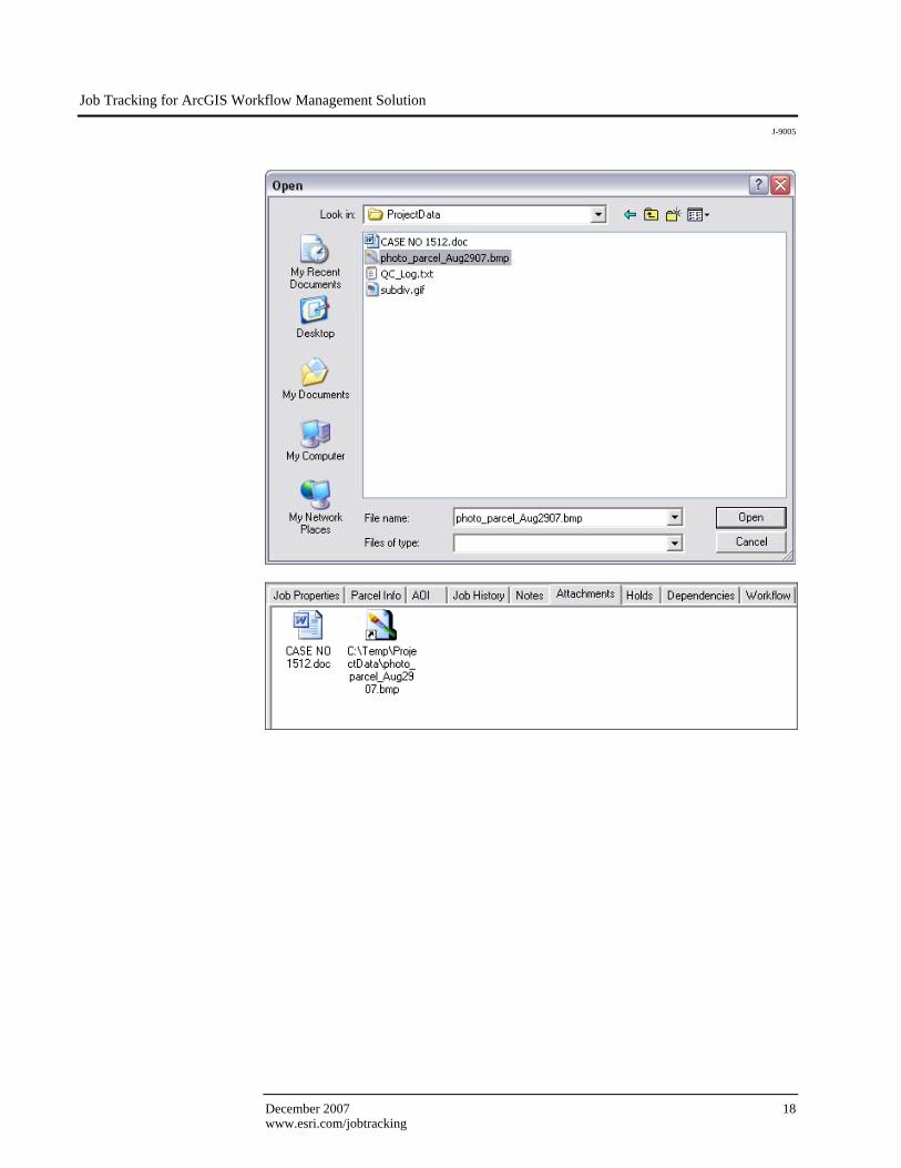
Add File Attachment A file may contain additional information that would assist you in performing your tasks. In this case, imagery of the subdivision area will be attached to the job and referenced to its location in the department's source inventory file system. Click the Add button, choose to add the file As Link, and browse to its location on the file system.
Job Tracking for ArcGIS Workflow Management Solution
J-9005
December 2007 18 www.esri.com/jobtracking
Job Tracking for ArcGIS Workflow Management Solution
J-9005
ESRI White Paper 19 www.esri.com/jobtracking
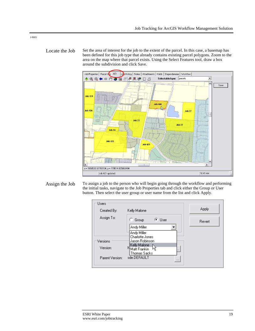
Locate the Job Set the area of interest for the job to the extent of the parcel. In this case, a basemap has been defined for this job type that already contains existing parcel polygons. Zoom to the area on the map where that parcel exists. Using the Select Features tool, draw a box around the subdivision and click Save.
Assign the Job To assign a job to the person who will begin going through the workflow and performing the initial tasks, navigate to the Job Properties tab and click either the Group or User button. Then select the user group or user name from the list and click Apply.
Job Tracking for ArcGIS Workflow Management Solution
J-9005
December 2007 20 www.esri.com/jobtracking
Take Up the Job and Begin Working
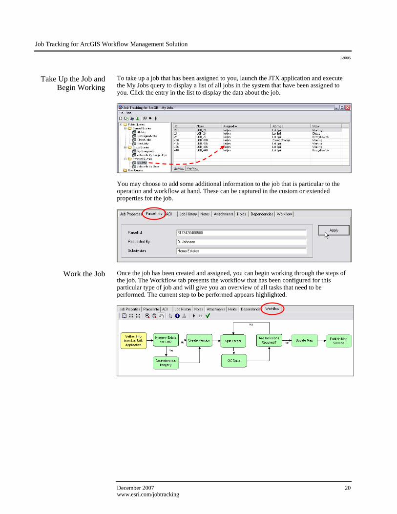
To take up a job that has been assigned to you, launch the JTX application and execute the My Jobs query to display a list of all jobs in the system that have been assigned to you. Click the entry in the list to display the data about the job.
You may choose to add some additional information to the job that is particular to the operation and workflow at hand. These can be captured in the custom or extended properties for the job.
Work the Job Once the job has been created and assigned, you can begin working through the steps of the job. The Workflow tab presents the workflow that has been configured for this particular type of job and will give you an overview of all tasks that need to be performed. The current step to be performed appears highlighted.
Job Tracking for ArcGIS Workflow Management Solution
J-9005
ESRI White Paper 21 www.esri.com/jobtracking
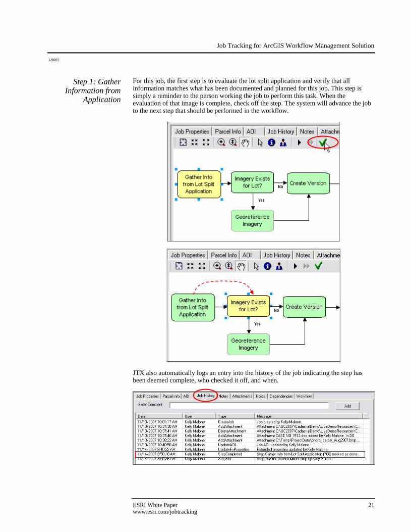
Step 1: Gather Information from
Application
For this job, the first step is to evaluate the lot split application and verify that all information matches what has been documented and planned for this job. This step is simply a reminder to the person working the job to perform this task. When the evaluation of that image is complete, check off the step. The system will advance the job to the next step that should be performed in the workflow.
JTX also automatically logs an entry into the history of the job indicating the step has been deemed complete, who checked it off, and when.
Job Tracking for ArcGIS Workflow Management Solution
J-9005
December 2007 22 www.esri.com/jobtracking
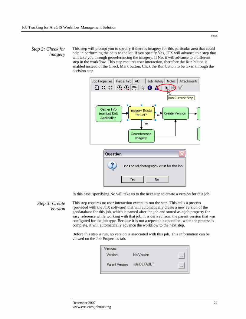
Step 2: Check for Imagery
This step will prompt you to specify if there is imagery for this particular area that could help in performing the edits to the lot. If you specify Yes, JTX will advance to a step that will take you through georeferencing the imagery. If No, it will advance to a different step in the workflow. This step requires user interaction, therefore the Run button is enabled instead of the Check Mark button. Click the Run button to be taken through the decision step.
In this case, specifying No will take us to the next step to create a version for this job.
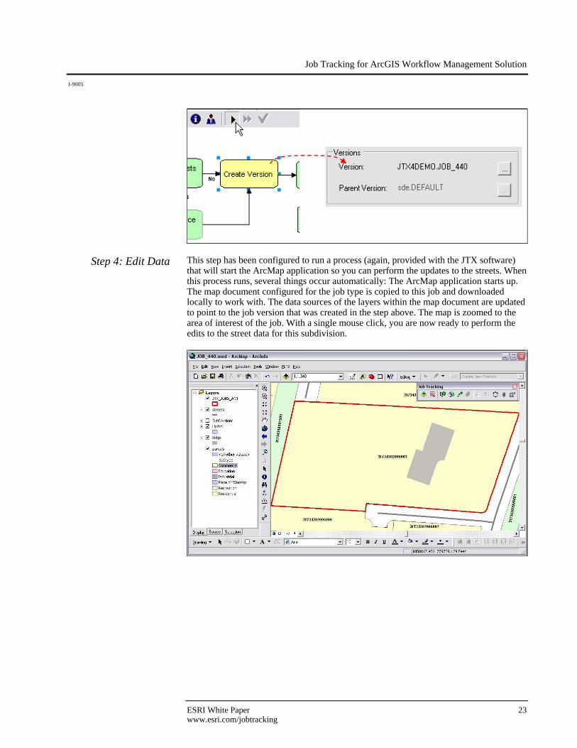
Step 3: Create Version
This step requires no user interaction except to run the step. This calls a process (provided with the JTX software) that will automatically create a new version of the geodatabase for this job, which is named after the job and stored as a job property for easy reference while working with that job. It is derived from the parent version that was configured for the job type. Because it is not a repeatable operation, when the process is complete, it will automatically advance the workflow to the next step. Before this step is run, no version is associated with this job. This information can be viewed on the Job Properties tab.
Job Tracking for ArcGIS Workflow Management Solution
J-9005
ESRI White Paper 23 www.esri.com/jobtracking
Step 4: Edit Data This step has been configured to run a process (again, provided with the JTX software) that will start the ArcMap application so you can perform the updates to the streets. When this process runs, several things occur automatically: The ArcMap application starts up. The map document configured for the job type is copied to this job and downloaded locally to work with. The data sources of the layers within the map document are updated to point to the job version that was created in the step above. The map is zoomed to the area of interest of the job. With a single mouse click, you are now ready to perform the edits to the street data for this subdivision.
Job Tracking for ArcGIS Workflow Management Solution
J-9005
December 2007 24 www.esri.com/jobtracking
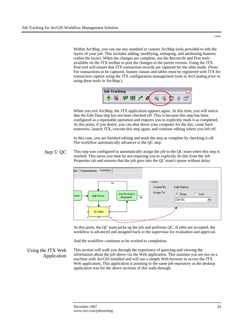
Within ArcMap, you can use any standard or custom ArcMap tools provided to edit the layers of your job. This includes adding, modifying, reshaping, and attributing features within the layers. When the changes are complete, use the Reconcile and Post tools available on the JTX toolbar to post the changes to the parent version. Using the JTX Post tool will ensure that JTX transaction records are captured for the edits made. (Note: For transactions to be captured, feature classes and tables must be registered with JTX for transaction capture using the JTX configuration management tools in ArcCatalog prior to using these tools in ArcMap.)
When you exit ArcMap, the JTX application appears again. At this time, you will notice that the Edit Data step has not been checked off. This is because this step has been configured as a repeatable operation and requires you to explicitly mark it as completed. At this point, if you desire, you can shut down your computer for the day, come back tomorrow, launch JTX, execute this step again, and continue editing where you left off. In this case, you are finished editing and mark the step as complete by checking it off. The workflow automatically advances to the QC step.
Step 5: QC This step was configured to automatically assign the job to the QC team when this step is reached. This saves you time by not requiring you to explicitly do this from the Job Properties tab and ensures that the job goes into the QC team's queue without delay.
At this point, the QC team picks up the job and performs QC. If edits are accepted, the workflow is advanced and assigned back to the supervisor for evaluation and approval. And the workflow continues to be worked to completion.
Using the JTX Web
Application This section will walk you through the experience of querying and viewing the information about the job above via the Web application. This assumes you are not on a machine with ArcGIS installed and will use a simple Web browser to access the JTX Web application. This application is pointing to the same job repository as the desktop application was for the above sections of this walk-through.
Job Tracking for ArcGIS Workflow Management Solution
J-9005
ESRI White Paper 25 www.esri.com/jobtracking
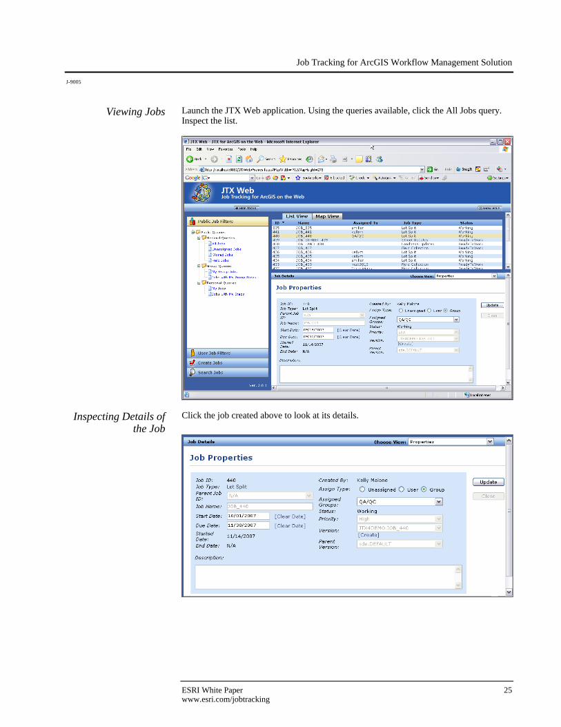
Viewing Jobs Launch the JTX Web application. Using the queries available, click the All Jobs query. Inspect the list.
Inspecting Details of the Job
Click the job created above to look at its details.
Job Tracking for ArcGIS Workflow Management Solution
J-9005
December 2007 26 www.esri.com/jobtracking
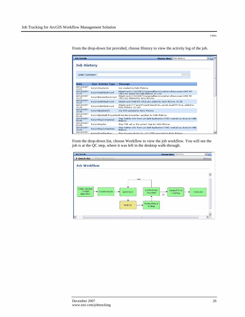
From the drop-down list provided, choose History to view the activity log of the job.
From the drop-down list, choose Workflow to view the job workflow. You will see the job is at the QC step, where it was left in the desktop walk-through.
Job Tracking for ArcGIS Workflow Management Solution
J-9005
ESRI White Paper 27 www.esri.com/jobtracking
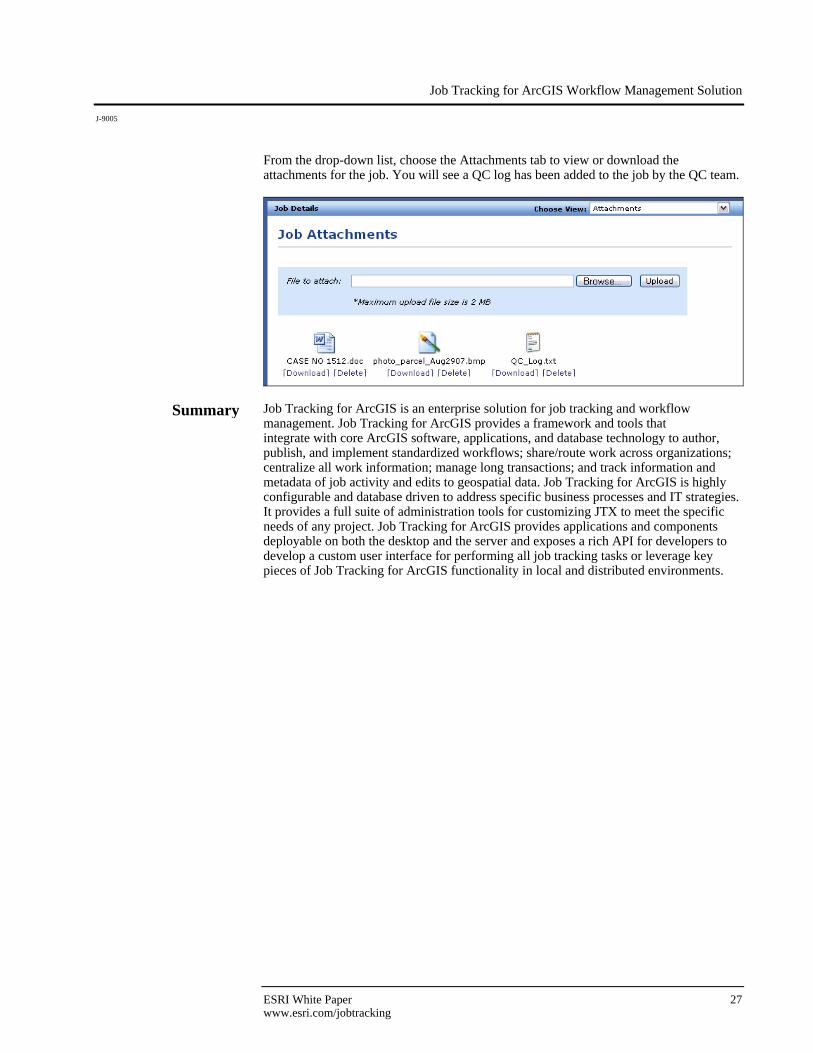
From the drop-down list, choose the Attachments tab to view or download the attachments for the job. You will see a QC log has been added to the job by the QC team.
Summary Job Tracking for ArcGIS is an enterprise solution for job tracking and workflow management. Job Tracking for ArcGIS provides a framework and tools that integrate with core ArcGIS software, applications, and database technology to author, publish, and implement standardized workflows; share/route work across organizations; centralize all work information; manage long transactions; and track information and metadata of job activity and edits to geospatial data. Job Tracking for ArcGIS is highly configurable and database driven to address specific business processes and IT strategies. It provides a full suite of administration tools for customizing JTX to meet the specific needs of any project. Job Tracking for ArcGIS provides applications and components deployable on both the desktop and the server and exposes a rich API for developers to develop a custom user interface for performing all job tracking tasks or leverage key pieces of Job Tracking for ArcGIS functionality in local and distributed environments.
Australia www.esriaustralia.com.au
Belgium/Luxembourg www.esribelux.com
Bulgaria www.esribulgaria.com
Canada www.esricanada.com
Chile www.esri-chile.com
China (Beijing) www.esrichina-bj.cn
China (Hong Kong) www.esrichina-hk.com
Finland www.esri-finland.com
France www.esrifrance.fr
Germany/Switzerland www.esri-germany.de www.esri-suisse.ch
Hungary www.esrihu.hu
India www.esriindia.com
Indonesia www.esrisa.com.my
Italy www.esriitalia.it
Japan www.esrij.com
Korea www.esrikr.co.kr
Malaysia www.esrisa.com.my
Netherlands www.esrinl.com
Northeast Africa 202-516-7485
Poland www.esripolska.com.pl
No. GS-35F-5086H
Printed in USA
ESRI International Offices
ESRI Regional Offices
Olympia 360-754-4727
St. Louis 636-949-6620
Minneapolis 651-454-0600
Philadelphia 610-644-3374
Boston 978-777-4543
Washington, D.C. 703-506-9515
Charlotte 704-541-9810
San Antonio 210-499-1044
Denver 303-449-7779
California 909-793-2853 ext. 1-1906
Portugal www.esri-portugal.pt
Romania www.esriro.ro
Singapore www.esrisa.com
Spain www.esri-es.com
Sweden www.esri-sgroup.se
Thailand www.esrith.com
Turkey www.esriturkey.com.tr
United Kingdom www.esriuk.com
Venezuela www.esriven.com
1-800-GIS-XPRT (1-800-447-9778)
www.esri.com
Locate an ESRI value-added reseller near you at
www.esri.com/resellers
Outside the United States, contact your local ESRI distributor. For the number of your distributor, call ESRI at 909-793-2853, ext. 1-1235, or visit our Web site at
www.esri.com/distributors
For More Information
ESRI 380 New York Street Redlands, California 92373-8100 USA
Phone: 909-793-2853Fax: 909-793-5953 E-mail: [email protected]
For more than 35 years, ESRI has
been helping people make better
decisions through management
and analysis of geographic
information. A full-service GIS
company, ESRI offers a framework
for implementing GIS technology
and business logic in any
organization from personal GIS on
the desktop to enterprise-wide GIS
servers (including the Web) and
mobile devices. ESRI GIS solutions
are flexible and can be customized
to meet the needs of our users.