j, 46'w - aris.empr.gov.bc.ca
TRANSCRIPT

n Report on a Geochemical Survey Rob Mineral C l a i
Jesse Creek, f ~ l c o l a Minlng uivision
\J, 120° 46'W 1. (N.P .ura Mil
by MacDonald Lonsultants Ltd. P. St,

T E L E P H O N E 681.7493
M A c D O N A L D C O N S U L T A N T S L T D . S U I T E 1 2 - 4 2 5 H O W E S T R E E T . V A N C O U V E R 1 . B . C .
REPORT ON A GEOCHEMICAL SURVEY
Rob Mineral Claim Group
J e s s e Creek, B. C.
Nicola Mining Div is ion
500 l l ' N , 120° 46'W
f o r
LAURA MINES LTD. (N.P.L.)
MacDonald Consul tan ts Ltd.
12 - 425 Howe S t r e e t
Vancouver 1, B. C.
M. P. Stadnyk, B. Sc.
August 8 , 1968

TABLE OF CONTENTS
Introduction
Location and Access
Physiography
Mineral Claims
History
Area of Survey
Sampling Procedure
Geochemical Testing
Results of Geochemical Survey for Copper
Physical Work G Trenching
Personnel
Rental Equipment
Conclusions & Recommendations
Page
1
1
1
2
2
2
2
3
3
3
4
4
4
Expenditures
Certificate
Maps : - Location Map di ' Scale - 1 inch to 2 miles
7if I Geochemical Survey Map "- 1 inch to 400 feet
Mineral Claims - Workings Map /i?
;A/ Geochemical Lab Reports - 16 Pages

INTRODUCTION
Geochemical surveying and caterpillar trenching were carried out on
the Rob mineral claims, Jesse Creek, B. C., Nicola Mining Division, between
July 13 and 22, 1968.
Five hundred twenty-seven soil samples were taken on a grid totalling
some nineteen line miles.
Trenching was based on a geophysical survey conducted in 1966. Six
deep trenches were dug, none of which reached bedrock.
LOCATION AND ACCESS
The Rob #1 - 8 mineral claims are situated on Jesse Creek, four miles north of Merritt, B. C.
Co-ordinates are - latitude 50° ll'N, longitude 120° 46'W.
Access is by road from Merritt north along Highway No. 8 for 3.5 miles
to the Mamit Lake Road. Then north along Mamit Lake road for 1.1 miles
and eastwards up Jesse Creek for five miles.
The enclosed map shows roads and location of the Rob mineral claim
group
PHYSIOGRAPHY
Elevation of the minera 1 claims varies from 3700 to 4200 feet.
Relief is moderate to gentle except where Jesse Creek cuts through
deep glacial overburden.
Jesse Creek flows south~westwards to Guichon Creek which in turn
flows south to join the Nicola River at Coutlee.
Deep trenches indicate the glacial deposits in this area exceed twenty-
five feet in depth.

r d ; .- , 1
Mines and Petroleum kesources
ASSESSMENT REPORT
ROB MINERAL

Vegetation consists of thick stands of pines, alders, and large open
fields of grass. Very little underbrush was seen except along stream beds,
MINERAL CLAIMS
Laura Mines Ltd. (N.P.L.) own the following mineral claims on Jesse
Creek, B. C., Nicola Mining Division:-
Rob 1 - 8 inclusive Record Numbers 24901 - 24908 inclusive HI STORY
Rob 1 - 8 mineral claims were staked in August, 1965. An electromag-
netic survey was carried out by Marc van Roechoudt in June, 1966. This
was followed by a magnetometer survey and trenching under the supervision
of Harvey H. Cohen, P, Eng. later in 1966.
AREA OF SURVEY
The geochemical survey was conducted over a grid totalling some nine-
teen line miles, The grid control was established by chain and compass.
Origin of the grid was placed at the centre of the property with the
base line 3200 feet north and 3600 feet south. Cross lines run east and
west 1400 to 1800 feet and cross the base line at 200 foot intervals.
All lines were blazed and flagged.
SAMPLING PROCEDURE
Soil samples were taken at 200 foot intervals and each sample site
flagged.
Texture of soil, colour, depth, slope and vegetation cover was noted
for each sample. The B horizon of the soil profile was sampled wherever
possible.

GEOCHEMICAL T$STING
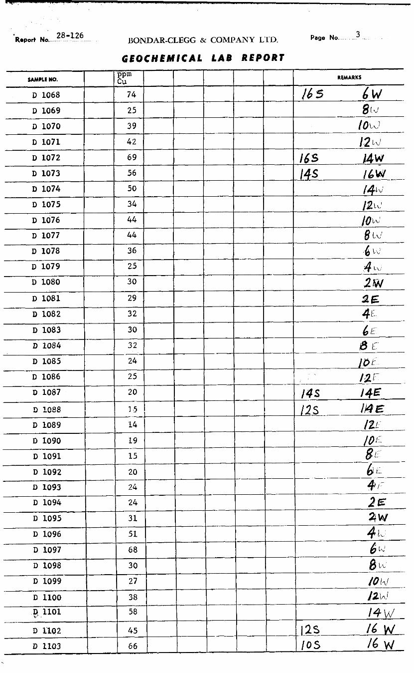
Geochemical testing was carried out by Bondar-Clegg and Company
Ltd., North Vancouver, B. C. All samples were tested for copper using
Hot HNO3 - HC1 acid extraction method and values obtained by atomic absorption, Assay results for copper in parts per million are included
with this report, The enclosed geochimilal map shows copper values in
excess of 41 ppm.
RESULTS OF GEOCHEMICAL SURVEY FOR COPPER
Background value for copper on the Rob mineral claims was estimated
to lie between 40 and 60 ppm. Of a total number of 527 samples only 30
had readings of greater than background, and the majority of these are so
scattered that they are of little use in the search for zones of copper
mineralization.
Only one area has been indicated as a possible target for further
exploration, This is a small V-shaped anomaly extending from 30S, 4W to
26S, 2W on one limb and to 28S, 6W on the other limb. This area also coincides
with a magnetometer anomaly of 800 gammas.
PHYSICAL WORK - TRENCHING A caterpillar model D7E equipped with rippers was contracted from
TrimValley Construction Ltd., Princeton, B. C. to trench on the Rob mineral
claims.
Location of trenches were based upon magnetic anomalies detected by
He Cohen's geophysical survey in 1966. Magnetic highs appear to correlate
well with exceptionally deep overburden (drumlins) especially at the south

end of the property. Trenches here were dug to a depth of 21 feet, and the
rippers did not strike bedrock below this depth (i.e. down to 25 feet).
The enclosed map shows positions of trenches dug in 1966.
Dimensions of these trenches are:-
Trench No. Length % Floor Greatest Average Width Width Dewth Dewth
PERSONNEL
The geochemical survey was carried out by MacDonald Consultants Ltd.
of Vancouver, B. C., between July 13 and 22, 1968.
Maximum number of men used was three under the supervision of the
author.
RENTAL EQUIPMENT
A 1967 Dodge Transivan was rented from Brentwood Dodge Leasing Ltd.;
a tent, camper and other miscellaneous equipment were rented from MacDonald
Consultants Ltd. to provide transportation and accommodation for the crew.
CONCLUSIONS AND RECOMMENDATIONS
Deep trenching was also carried out during the same period as the
soil samples were taken. Assays of these samples show that two trenches
were dug where copper values were greater than background. In both cases
only small amounts of malachite float were found. Disappointing as this

may be, it should be noted that no trench reached bedrock, even those dug
to a depth of twenty-five feet, nor for that matter was any outcrop found
on the property.
The V-shaped geochemical anomaly which coincides in part with a high
magnetometer anomaly at the southern end of the property indicates the
area where future work should be conducted.
However, as the ground to the south and west of the Rob mineral claim
group is held by other companies, and since the geochemical anomaly on
Rob #5 mineral claim is small, no further work can be recommended for this
property at the present time.
Respectfully submitted,
MACDONALD CONSULTANTS LTD .
M. P, Stadnyk, B. Sc.

EXPENDITURES
Line Cutting, Soil Sampling
29 line miles
3 Min - 5 days @ $30.00 per day, July 13-17, 1968
2 Men - 5 days @ $30.00 per day, July 18-22, 1968
Assaying
Copper determinations
527 samples @ $1.15 per sample
Physical Work - Trenching Caterpillar D7E + Rippers - Tri-Valley Construction Ltd. 44 hours @ $24.00 per hour 1,056.00
Helper - 4 days @ $30.00 per day 120.00
Rental Equipment
Brentwood - Dodge Leasing Ltd. - Dodge Transivan MacDonald Consultants Ltd.
1. Camper - $6.00 per day + mileage
2. Tent
3. Field Equipment
Operating Expenses
Food - Sundries Report
Total

TELEPHONE 6 8 1 - 7 4 9 3
M A c D O N A L D C O N S U L T A N T S L T D . S U I T E 1 2 - 4 2 5 H O W E S T R E E T , V A N C O U V E R I . B . C .
CERTIFICATE
I, Mike Peter Stadnyk of Vancouver, B. C. do #ereby certify that:-
1, I am a Mining Exploration Geologist residing at 1445 West 11th Avenue,
Vancouver, B, C.
2. I am a graduate of the University of New Zealand and have practised my
profession in Canada for the past eight years.
3, I am employed by MacDonald Consultants Ltd., Vancouver, B. C.
4. I currently hold 2500 shares of capital stock of Laura Mines Ltd. (N.P.L.).
5. Information contained in this report was based upon work carried out by
me on at my dirktion between the period of July 13 to 22, 1968,
Respectfully submitted,
MACDONALD CONS ANTS LTD.
/&?.p?2dL-/ M. P. Stadnyk, B. Sc. Geologist
August 8, 1968
Vancouver, B, C.


'bport No. 28-126 BONDAR-CLEGG & COMPANY LTD. Page No. 2
G E O C H E M I C A L LAB REPORT
SAMPLE No.
D 1032
D 1033
D 1034
D 1035
D 1036
D 1037
D 1038
PP"' Cu
31
40
3 5
39
29
32
33
REMARKS
? f % > d c 2 E 2 1J 4h t 14'
1 1%
, - . , -
Report No. 28-126 BONDAR-CLEGG & COMPANY LTD. Page No. 3
GEOCHEMICAL LAB REPORT
REMARKS
16 5 6~ 8 rz!
f0L1 12 1 ~ )
16s 14w 14s i6w --
/4tu1
SAMPLE No.
D 1068
D 1069
D 1070
D 1071
D 1072
D 1073
D 1074
PPm Cu
7 4
2 5
39
4 2
6 9
56
50

Report No. 28-126 BONDAR-CLEGG & COMPANY LTD.
G E O C H E M I C A L LAB REPORT
SAMPLE No. PP=' Cu REMARKS

%port No. 28-126 BONDAR-CLEGG & COMPANY LTD. Page No. 5
G E O C H E M I C A L LAB REPORT
REMARKS
.:. '1 !!z q/E 4 I.< f E- .
SAMPLE NO.
- D 1140
D 1141
D 1142
D 1143
1) 1144
-.
8 r ' 38
16
17
17
26

Report No. 28-126 BONDAR-CLEGG & COMPANY LTD.
GEOCHEMICAL LAB REPORT
Page No. 6

Report No. 28-126 BONDAR-CLEGG & COMPANY LTD. Page No. 7
GEOCHEMICAL LAB REPORT
REMARKS
4- A' L#CL!
.2 ld
SAMPLE NO.
D 1214
D 1215
PPm Cu
44
24

Roport No. 28-126 BONDAR-CLEGG & COMPANY LID. Page No. 8
G E O C H E M I C A L L A B REPORT

28-126 Report No ...........,..... . . BONDAR-CLEGG & COMPANY L'TD.
G E O C H E M I C A L LAB REPORT
Page No. 9

Page No. 10 BONDAR-CLEGG & COMPANY LTD.
GEOCHEMICAL LAB REPORT
REMARKS

28-126 b p o r t No ............. BONDAR-CLEGG & COMPANY LTD. 11 Page No. . . ..
GEOCHEMICAL LAB R E P O R T
D 1587 34
D 1588
D 1589
D 1590
D 1591
D 1592
D 1593
D 1594
D 1595
D 1596 -
D 1597
D 1598
D 1599
D 1600
D 1601
D 1602
19
19
19 - 69
37
3 6
68
3 1
2 8
4 1
19
25
24
21
42 ----
D 1603 - -
D 1604
D 1605
--
27
29
40
-
-
I
-
h'
61 N - 4 /\I
2~ 13 1 I'+ c l
2 '3
4 4 - '
" f i \ (1'
17
i.1
Ii -
1;. - h i
22 2 -,
- 2C ' I, -

h p o r t No. 28 -126
- - -
W P U NO.
D 1 6 0 6
GEOCHEMICAL LAB REPORT
BONDAR-CLEGG & COMPANY LTD. 1 2 Page No ..... . . . . . .
REMARKS
I - - 2 8 h

28-126 Report No .................. . BONDAR-CLEGG & COMPANY L l D. Page No. 13
G E O C H E M I C A L LAB REPORT

Report No. 28-126 BONDAR-CLEGG & COMPANY L1 D. Page NO. 14
GEOCHEMICAL L A B REPORT
SAMPLE No. PPm Cu
D 1678 43
D 1679 64

ONDAR-CLEGG & COMPANY LTD.
E O C H E M I C A L LAB REPORT

