iv.h. land use planning · blvd 6200 iv.h. land use planning draft supplemental environmental...
TRANSCRIPT
BLVD 6200 IV.H. Land Use Planning Draft Supplemental Environmental Impact Report Page IV.H-1
IV. ENVIRONMENTAL IMPACT ANALYSIS H. LAND USE PLANNING
PREVIOUS ENVIRONMENTAL ANALYSIS
Under the Hollywood Redevelopment Plan Amendment, the CRA and the City Council re-established the CRA’s ability to acquire property by eminent domain which expired in 1998, but limited that authority to only property on which no persons lawfully reside. In addition, changes in State law since the Redevelopment Plan was originally adopted permit elimination of the time limit to establish loans, advances and indebtedness. The Plan Amendment included the following components:
• Revising schedules related to the preparation of various plans and studies.
• Adoption of an amended land use map to conform to the land use map of the existing Hollywood Community Plan that has been amended since the Redevelopment Plan was adopted in May 1986.
• Adoption of text that allows for continuing conformance with the land use map of the Hollywood Community Plan if the Community Plan is updated and amended subsequent to the adoption of the proposed Redevelopment Plan Amendment.
Land Use Compatibility
Construction
The 2003 Final EIR identified that construction activities which could result from the development occurring within the Hollywood Redevelopment Project Area could cause conflicts with adjacent uses during the construction period due to temporary increases in air emissions (including fugitive dust) and noise. Such construction impacts could result in temporary incompatibility between the short-term land use activity of project construction and adjacent sensitive land uses. Uses that are typically considered sensitive to noise and air pollution include residences, schools, parkland, hospitals and convalescent care facilities. These uses could experience significant impacts from construction–related air emissions and noise.
Operations
The 2003 Final EIR identified that development occurring within the Hollywood Redevelopment Project Area could result in incompatibilities with adjacent land uses. The development projected to occur would perpetuate the existing pattern within the Redevelopment Project Area, where residential, commercial and industrial land uses are, in many cases, located proximate to one another. Under existing Community Plan land use designations, as well as changes which might result from implementation of this development scenario, new commercial and industrial development along major roadway corridors could potentially occur near predominantly residential areas set back from the major roadways. In addition,

City of Los Angeles April 2006
BLVD 6200 IV.H. Land Use Planning Draft Supplemental Environmental Impact Report Page IV.H-2
increased intensity of land use could result in some parts of the Redevelopment Project Area as a result of future development. Possible sources of land use incompatibility could include: noise from traffic and other on-site sources, spillover parking into residential neighborhoods, odors, light and glare, pedestrian/vehicle conflicts, shade and shadow effects and handling of hazardous materials. However, land use compatibility impacts would be significant because land use conflicts could result from the operational characteristics of future development.
Land Use Regulation
Regional Comprehensive Plan and Guide
Development projected to occur in the Hollywood Redevelopment Project Area as a result of adopting the proposed Plan Amendment would serve to implement numerous regional growth policies set forth in the RCPG because it would enhance CRA’s ability to: encourage and support development and redevelopment activity in an existing developed area that is presently well-served by existing transit and transportation infrastructure; promote development of a mix of urban land uses; support the development of affordable housing within the Redevelopment Project Area; work toward the elimination of blight and promote improvements in the standard of living of the residents of the Redevelopment Project Area; and improve the existing infrastructure and public services within the Redevelopment Project Area.
General Plan Framework/Hollywood Community Plan
The General Plan Framework is implemented through the 35 Community/District Plans. Therefore consistency with the applicable Community Plan is equivalent to consistency with the General Plan Framework. The Hollywood Community Plan sets forth objectives and policies to ensure appropriate land use planning within Hollywood. The 2003 Final EIR identified that development within the Hollywood Redevelopment Project Area would be consistent with the objectives of the Hollywood Community Plan because it would enhance CRA’s ability to: promote the development and redevelopment of the Hollywood community; attract private investment to the community; eliminate conditions of blight within the community; and improve transportation and other infrastructure systems within the community.
The 2003 Final EIR identified that future development within the Hollywood Redevelopment Project Area could require changes to existing zoning designations in order to accommodate residential and commercial development densities in some parts of the Redevelopment Project Area. These may exceed the maximum densities presently allowed under existing zoning classifications. However, the land uses would be generally consistent with the land use designations set forth in the Hollywood Community Plan.
Mitigation Measures
The 2003 Final EIR identified that following mitigation measures to be applied to future projects within the Redevelopment Project Area to address temporary land use incompatibility during construction activities:
City of Los Angeles April 2006
BLVD 6200 IV.H. Land Use Planning Draft Supplemental Environmental Impact Report Page IV.H-3
• All projects shall be required to implement mitigation measures related to construction noise.
• All projects shall be required to implement mitigation measures related to construction air quality.
The following mitigation measures shall be applied to future projects within the Redevelopment Project Area to address land use incompatibilities during operational activities:
• All projects shall be required to implement relevant mitigation measures related to impacts on adjacent land uses.
• The CRA’s discretionary approvals and ministerial (i.e., permit) reviews of developments within the Redevelopment Project Area shall consider the effects of commercial or industrial activities on adjacent residential properties. Site plan and project design reviews shall be conducted for all future projects requiring a building permit to ensure that projects that could affect residential areas are appropriately screened to mitigate light, glare, noise, hazardous materials, traffic and parking effects. Screening techniques that may be identified by the CRA for incorporation could include landscaping, site design modifications, screening walls or traffic calming and parking restrictions on residential streets. Mitigation measures shall be designed to achieve the following, as appropriate: reduce noise levels to the acceptable levels set forth in the community compatibility noise guidelines of the General Plan; eliminate light spillover onto residential properties; eliminate parking spillover into residential areas; eliminate sources of glare that reflect into residential areas; eliminate sources of odor generation that affect adjacent residential uses; eliminate excessive shading of residential properties; minimize risks to adjacent residential properties resulting from the handling of hazardous materials. Any screening or physical design measures identified by the CRA to be necessary to mitigate land use incompatibilities shall be included as Conditions of Approval for the project.
Because no impacts related to land use plans and policies were identified to result from the Proposed Project, no mitigation measures are required.
ENVIRONMENTAL SETTING
Surrounding Land Uses
The project site is located in Los Angeles County, within the Hollywood community of the City of Los Angeles. The project site is roughly bounded by Carlos Avenue on the north, Argyle Avenue on the west, Selma Avenue on the south, and El Centro Avenue on the east. The project site is split roughly in half on an east/west axis by Hollywood Boulevard. A segment of Vista Del Mar Avenue between Hollywood Boulevard and Carlos Street bisects the northern portion of the project site. The project site consists of multiple parcels totaling approximately 7.3 acres (including the Vista Del Mar segment and the alley located between Argyle Avenue and El Centro Avenue south of and parallel to Hollywood Boulevard).
The area surrounding the project site is developed with multi-family residential and commercial land uses and surface parking lots. Single- and multi-family residences are located north and northeast of the north

City of Los Angeles April 2006
BLVD 6200 IV.H. Land Use Planning Draft Supplemental Environmental Impact Report Page IV.H-4
block, along Carlos Avenue and the segment of Vista Del Mar Avenue located north of Carlos Avenue to Yucca Street. Multi-family residential development also fronts portions of Franklin Avenue and Gower Street.
The Pantages Theater is located immediately west of the north block across Argyle Avenue. The Hollywood/Vine Metro Rail Red Line Station is located immediately west of the south block across Argyle Avenue. The station portal and plaza are surrounded by surface parking lots. The station plaza, surrounding parking lots and a small number of buildings along Vine Street have been assembled into a project site. This site has been approved for development by the City of Los Angeles and the Metropolitan Transportation Authority with a mixed commercial, hotel and residential development containing high-rise buildings up to 14 stories, along with transit facilities and enhanced connections to the Metro Rail station.
Commercial uses near the project site include local and regional serving retail and restaurant establishments. These uses are primarily concentrated along Hollywood Boulevard, Sunset Boulevard, Cahuenga Boulevard and Vine Street. Several theaters and entertainment-oriented destinations are also located within the project area. There are a number of theaters located within a one-quarter mile of the project site. These theaters include the Pantages Theater, The Palace, and the James A. Doolittle Theater. The Hollywood Palladium is also within a one-quarter mile radius of the project site. ArcLight Cinerama Dome is located southwest of the project site, on the south side of Sunset Boulevard between Ivar Avenue and Vine Street. West of the project site, tourist attractions are concentrated along Hollywood Boulevard, including Mann Chinese Theater and the Hollywood and Highland mixed-use development, retail and entertainment center. Auto-related uses are located along Hollywood Boulevard immediately east of the north side of the project site.
Commercial uses, including a large Bally’s fitness center and associated parking structure, are located on the east side of El Centro Avenue, adjacent to the south side of the project site. A segment of Vista Del Mar that loops from El Centro Avenue to Selma Avenue forms part of the site boundary at the southeastern edge of the project site. Five buildings are located along this segment of Vista Del Mar. Four of these were previously used for residential purposes and have been converted to commercial use. The fifth is a residential hotel. These buildings are not contiguous and are separated by parking lots and the Vista Del Mar roadway. Commercial buildings, parking structures and surface parking lots are located south of the project site along Selma Avenue.
Minimally light industrial uses in the project area are located along portions of Sunset Boulevard. These light industrial uses are primarily movie, radio and television studios, and auxiliary facilities for the entertainment industry, including Columbia Square, a large former broadcast center located southeast of the project site.
City of Los Angeles April 2006
BLVD 6200 IV.H. Land Use Planning Draft Supplemental Environmental Impact Report Page IV.H-5
Existing Land Use Regulations
Regional Comprehensive Plan and Guide
The project site is located within the six-county region which comprises the Southern California Association of Governments (SCAG) planning area. SCAG is a Joint Powers Agency with numerous roles and responsibilities relative to regional issues that cross jurisdictional boundaries. Included in SCAG's responsibilities is the preparation of the Regional Comprehensive Plan and Guide (RCPG) in conjunction with its constituent members and other regional planning agencies. The RCPG provides a general view of the plans of the various regional agencies that will affect local governments, or that respond to the significant issues facing southern California, including growth management, and is intended to serve as a framework for decision-making with respect to growth and changes that can be anticipated by the year 2015 and beyond. In addition, the RCPG proposes a strategy for voluntary use by local governments, which will assist them in addressing issues related to future growth and in assessing the potential impacts of proposed development projects within the context of the region.
Thirteen subregions have been recognized as partners in preparation of the RCPG and have submitted input to the plan to ensure that it reflects local concerns which form the basis of the region’s “bottom-up” planning process. The project site is located within the Los Angeles Subregion.
The RCPG includes five core chapters (Growth Management, Regional Mobility, Air Quality, Water Quality, and Hazardous Waste Management) which respond directly to the federal and State requirements placed on SCAG and form the basis for certification of local plans. Ancillary chapters within the RCPG (Economy, Housing, Human Resources and Services, Public Finance, Open Space and Conservation, Water Resources, Energy, and Integrated Waste Management) reflect other regional plans but are strictly advisory and establish no new mandates or policies for the region or the local governments. Adopted RCPG polices related to land use are contained primarily in Chapter 3 Growth Management. The purpose of the Growth Management Chapter is to present forecasts which establish the socio-economic parameters for the development of the Regional Mobility and Air Quality Chapters of the RCPG, and to address issues related to growth and land consumption by encouraging local land use actions which could ultimately lead to the development of an urban form that would help minimize development costs, save natural resources, and enhance the quality of life in the region. Impacts associated with air quality and regional mobility are discussed in Sections IV.C and IV.L, respectively.
Compass Growth Vision/Compass 2% Strategy Areas
The Compass Growth Vision, adopted by SCAG in June 2004, is an implementing mechanism for the regional growth strategies outlined in the RCPG. The Compass Growth Vision is intended to provide a strategy to accommodate the projected six million new residents expected to live in the region by 2030 while balancing valuable quality of life goals. The Compass Vision emphasizes focusing growth in existing and emerging centers and along major transportation corridors, creating significant areas of mixed-use development and walkable communities, target growth around existing and planned transit stations, and preserving existing open space and stable residential areas.

City of Los Angeles April 2006
BLVD 6200 IV.H. Land Use Planning Draft Supplemental Environmental Impact Report Page IV.H-6
The Compass Action Plan focuses on benefiting the local, subregional, and regional levels and identifies Compass Strategic Opportunity Areas for focused implementation of the Compass Growth Vision, which make up approximately two percent of the region. These Strategic Opportunity Areas are also called “Compass 2 % Strategy” areas. These areas are defined as having a high potential to implement projects, plans, and/or policies consistent with the Compass principles resulting in economic, mobility, and environmental benefits to the area. The project site is located in a Compass 2% Strategy Area.
City of Los Angeles General Plan Framework
California State law (Government Code Section 65300) requires that each City prepare and adopt a comprehensive, long-term general plan for its future development. This general plan must contain seven elements, including land use, circulation, housing, conservation, open space, noise and safety. In addition to these, State law permits cities to include optional elements in their general plans, thereby providing local governments with the flexibility to address the specific needs and unique character of their jurisdictions. California State law also requires that the day-to-day decisions of a City follow logically from and be consistent with the general plan. More specifically, Government Code Sections 65860, 66473.5 and 65647.4 require that zoning ordinances and subdivision and parcel map approvals be consistent with the general plan.
The City of Los Angeles General Plan is a comprehensive, long range declaration of purposes, policies and programs for the development of the City of Los Angeles. The General Plan is a dynamic document consisting of eleven elements, which include ten Citywide elements (Air Quality Element, Conservation Element, Historic Preservation and Cultural Resources Element, Housing Element, Infrastructure Systems Element, Noise Element, Open Space Element, Public Facilities and Services Element, Safety Element, and Transportation Element) and the Land Use Element, also known as the Community Plan, for each of the City’s 35 Community Planning Areas. The General Plan Framework Element is a strategy for long-term growth which sets a citywide context to guide the update of the community plan and citywide elements. The General Plan Framework Element responds to State and federal mandates to plan for the future. The City of Los Angeles uses population forecasts provided by the Southern California Association of Governments (SCAG) to plan for long-term growth.
The General Plan Framework Element sets forth a citywide comprehensive long-range growth strategy. It defines citywide policies that will be implemented through subsequent amendments of the City's community plans, zoning ordinances, and other pertinent programs. The General Plan Framework Element also contains policies that are intended to maintain the City of Los Angeles’s cultural and natural diversity. The General Plan Framework Element provides guidelines for future updates of the City's community plans. It does not supersede the more detailed community and specific plans.
Hollywood Community Plan
One of the City’s 35 Community Planning Areas that make up the Land Use Element is the Hollywood Community Plan Area. The project site is located in the Hollywood Community Plan Area. The purpose of the Hollywood Community Plan is to:
City of Los Angeles April 2006
BLVD 6200 IV.H. Land Use Planning Draft Supplemental Environmental Impact Report Page IV.H-7
“provide an official guide to the future development of the Community for the use of the City Council, the Mayor, the City Planning Commission; other concerned government agencies, residents, property owners, and business people of the Community; and private organizations concerned with planning and civic betterment. . . The Plan is intended to promote an arrangement of land use, circulation, and services which will encourage and contribute to the economic and social and physical health, safety, welfare, and convenience of the Community, within the larger framework of the City; guide development, betterment, and changed of the Community to meet the existing and anticipated needs and conditions; balance growth and stability; reflect economic and potentials and limits, land development and other trends; and protect investment to the extent reasonable and feasible.”
Most of the project site is designated for “regional center commercial” use in the Hollywood Community Plan. A single parcel at the northeast corner of the project site is designated for “medium density residential” use in the Community Plan. The medium density residential land use designation is a residential designation which allows for the construction of multiple family residential uses such as apartments, condominiums, and multiple family housing units.
An update to the Community Plan is also currently being prepared for the Hollywood area by the Department of City Planning. While initial drafts of this plan are not available for public review, no down-zoning at the Project site is currently anticipated. Additionally, it is anticipated that the new community plan will make special provision for increased density and height for projects along transit corridors, specifically those near Metro Red Line stations.
Development of the Proposed Project would include the construction of up to 1,042 residential rental units, and approximately 175,000 square feet of retail uses would be provided in multiple tenant spaces fronting Hollywood Boulevard and Argyle Avenue. The Project Applicant has requested a height district change to modify applicable “D” development limitation and maximum height permitted on the northeast (R3) parcel, a zone change to remove “Q” conditions applicable to portions of the northeast parcel, variances for development of R3 parcel, front, side and/or rear yard variances, and a zone variance for unified development across the boundary between C4 and R3 zones (see discussion below).
Hollywood Redevelopment Plan
The project site is located in the Hollywood Redevelopment Project Area (the “Redevelopment Project Area”). The Redevelopment Project Area encompasses 1,107 acres of mixed use development including residential, commercial, light industrial, public and quasi-public uses. The Hollywood Redevelopment Plan provides CRA with powers, duties and obligations to implement and further the redevelopment, rehabilitation, and revitalization of the Redevelopment Project Area. Redevelopment of the Hollywood Redevelopment Project Area pursuant to the Hollywood Redevelopment Plan will attain the purposes of the California Community Redevelopment Law through:
“(1) the elimination of areas suffering from depreciated values, impaired investments, and economic and social maladjustment; (2) by the replanning, redesign and rehabilitation and/or
City of Los Angeles April 2006
BLVD 6200 IV.H. Land Use Planning Draft Supplemental Environmental Impact Report Page IV.H-8
development of areas which are stagnant or improperly utilized and which could not be accomplished by private enterprise acting alone, without public participation and assistance; and (3) by protecting and promoting sound development and redevelopment of blighted areas and the general welfare of the citizens of the City by remedying such injurious conditions through the employment of appropriate means.”
The Hollywood Redevelopment Plan specifically allows for the retention and expansion of entertainment related uses in Hollywood, and creation of housing units for low and moderate income residents, and appropriate provisions of social service facilities and programs.
Hollywood Signage Supplemental Use District
Ordinance 176,172 established the Hollywood Signage Supplemental Use District (Hollywood Signage SUD). This ordinance was enacted to acknowledge and promote the continuing contribution of signage to the distinctive aesthetic of Hollywood, as well as to control the blight created by poorly placed, badly designed signs throughout Hollywood. Specifically, the Ordinance seeks to: 1) provide for the systematic execution of the Hollywood Community Plan and Redevelopment Plan; 2) promote appropriate and economically viable signage; 3) limit visual clutter by regulating the number, size, and location of signs; 4) minimize potential traffic hazards and protect public safety; 5) protect street views and scenic vistas of the Hollywood Sign and the Hollywood Hills; and 6) protect and enhance major commercial corridors and properties. Except for the parcels located at the northeastern corner of the project site (zoned (Q)R3-1XL) and south of the alley located on the south side of the project site (zoned C4-2D), the Proposed Project is located within the established boundaries of the Hollywood Signage SUD.
Under the Hollywood Signage SUD, there are specific standards for Supergraphic Signs. Supergraphic Signs are defined as “a sign, consisting of an image which is applied to and made integral with a wall, or projected onto a wall or printed on vinyl, mesh or other material, and which does not comply with the provisions of Section 91.6201 et seq. of the Municipal Code, relating to wall signs, mural signs, off-site signs and/or temporary signs.” According to the Hollywood Signage SUD, a Supergraphic Sign may include off-site advertising and shall comply with the following standards:
• A Supergraphic Sign shall not be allowed on any lot where a billboard or solid panel roof sign is located.
• To qualify for a Supergraphic Sign an applicant shall participate in the sign reduction program, pursuant to Section 9 of the Hollywood Signage SUD.
• The exposed face of a Supergraphic Sign shall be approximately parallel to the plane of the wall upon which it is located.
• A maximum of two Supergraphic Signs may be located on a building provided the images are located on opposite walls of the building and cannot be viewed at the same time from any location.
• A Supergraphic Sign shall be at least 1,200 square feet in size.

City of Los Angeles April 2006
BLVD 6200 IV.H. Land Use Planning Draft Supplemental Environmental Impact Report Page IV.H-9
• The written message, including logos, shall not exceed 15 percent of the total area of the sign.
Section 6 of the Hollywood Signage SUD provides that all applications for signs within a redevelopment project area shall be approved by the CRA staff for that area, pursuant to any regulations or design guidelines adopted by the CRA.
CRA’s Amended Design for Development for Signs in Hollywood
Section 503 of the Redevelopment Plan authorizes the CRA to prepare and adopt designs for development that establish design criteria and other development and design controls necessary for proper development of both private and public area.
On January 20, 2005, the CRA Board adopted the Amended Design for Development For Signs in Hollywood (Amended Sign DFD). The purposes of the Amended Sign DFD are as follows:
• Provide for the systematic execution of the Hollywood Redevelopment Plan.
• Promote appropriate and economically viable signage that:
Uses clear, attractive graphics;
Coordinates with the architectural elements of the building on which signage is located;
Reflects a modern, vibrant image of Hollywood as the global center of the entertainment industry; and
Compliments and protects the character-defining features of historic buildings.
• Limit visual clutter by regulating the number, size and location of signs.
• Minimize potential traffic hazards and protect public safety.
• Protect street views and scenic vistas of the Hollywood Sign and the Hollywood Hills.
• Protect and enhance major commercial corridors and properties.
• Encourage and promote the removal of billboards and pole signs in the Project Area and Hollywood Community Plan area thus reducing visual clutter in the community.
The Amended Sign DFD includes standards that are generally the same as the Hollywood Sign SUD, with some refinements and restrictions that are intended to implement CRA's efforts in meeting the goals and objectives of the Hollywood Redevelopment Plan.
City of Los Angeles April 2006
BLVD 6200 IV.H. Land Use Planning Draft Supplemental Environmental Impact Report Page IV.H-10
Existing Zoning
Most of the project site is designated for “regional center commercial” use in the Hollywood Community Plan and is zoned C4-2D, C4-2D-SN and [Q]C4-2D-SN as shown in Figure IV.H-1 Zoning Map. A single parcel at the northeast corner of the project site is zoned [Q]R3-1XL and is designated for “medium density residential” use in the Community Plan. C4 is a commercial zoning designation which allows for the construction of residential uses. Additionally, pursuant to LAMC, Section 12.22-A.20, high-density multi-family housing uses permitted in the R5 zone (up to one dwelling unit per 200 square feet of lot area) are also permitted in the C4-zoned portions of the project site because the project site is located in an area designated for “Regional Center” uses in the adopted community plan within an approved redevelopment area.
Pursuant to LAMC Section 12.22 A.18(c)(3), no yard requirements shall apply to the residential portions of buildings located on lots in the C4 zone used for combined commercial and residential uses, if such portions abut a street, private street or alley, and the first floor of such buildings at ground level is used for commercial uses or for access to the residential portions of such buildings.
R3 is a residential zoning designation which allows for the construction of multiple family residential uses such as apartments, condominiums, and multiple family housing units. The R3 zoning designation is consistent with the Multiple Family, Medium Density general plan land use designation of the project site. Zoning for the parcels adjacent to the project site is C4-2D (regional center commercial).
Air Quality Management Plan
The Proposed Project is also located within the South Coast Air Basin and therefore is within the jurisdiction of the South Coast Air Quality Management District (SCAQMD). In conjunction with SCAG, SCAQMD is responsible for formulating and implementing air pollution control strategies. The Air Quality Management Plan (AQMP), (adopted in 1997 by SCAQMD and recently revised in August 2003) is intended to establish a comprehensive air pollution control program leading to the attainment of State and federal air quality standards in the South Coast Air Basin, thereby addressing the requirements set forth in the State and federal Clean Air Acts. SCAG assists SCAQMD in fulfilling these responsibilities. Section IV.C, Air Quality, provides a specific discussion of AQMP policies and the project’s conformance with such policies.
Congestion Management Plan
The Congestion Management Program (CMP) is a State-mandated program enacted by the State legislature to address the increasing concern that urban congestion is affecting the economic vitality of the State and diminishing the quality of life in many communities. As a new approach to addressing congestion concerns, the CMP was created to: 1) link land use, transportation, and air quality decisions; 2) develop a partnership among transportation decision makers on devising appropriate transportation solutions that include all modes of travel; and 3) propose transportation projects which are eligible to compete for State gas tax funds.

City of Los Angeles April 2006
BLVD 6200 IV.H. Land Use Planning Draft Supplemental Environmental Impact Report Page IV.H-11
Figure IV.H-1 Zoning Map
City of Los Angeles April 2006
BLVD 6200 IV.H. Land Use Planning Draft Supplemental Environmental Impact Report Page IV.H-12
The CMP, as adopted in 1992 and revised in 1995, includes a system of highways and roadways with minimum level of service (LOS) standards, transit standards, a trip reduction and travel demand management element, a program to analyze the impacts of local land use decisions on the regional transportation system, a seven-year capital improvement program, and a countywide computer model to evaluate traffic congestion and recommend relief strategies and actions. The CMP incorporates procedures for meeting deficiency plan requirements, or strategies that mitigate or improve congestion and air quality. Proposed projects which have the potential to affect the designated CMP network (mostly main-line freeway segments) are required to identify and mitigate their adverse effects on the network. Section IV.L, Traffic, provides an analysis of the project’s potential impact on the CMP network.
ENVIRONMENTAL IMPACTS
Thresholds of Significance
Based on criteria established in the City of Los Angeles CEQA Thresholds Guide, the Project would result in a significant land use impact if:
• The Proposed Project is inconsistent with the adopted land use/density designation in the Community Plan, Redevelopment Plan, or Specific Plan for the site;
• The Proposed Project is inconsistent with the goals and policies of the General Plan or adopted environmental goals or policies contained in other applicable plans; or
• The Proposed Project is incompatible with surrounding land uses or land use patterns.
Project Impacts
Land Use Compatibility with Surrounding Uses
The Project site is located in a heavily urbanized area in the Hollywood Community Plan Area of the City of Los Angeles. Land uses surrounding the Project site consist of a mix of single and multi-family residential uses, commercial uses and parking lots. The Pantages Theater is located to the west of the north block and the Hollywood/Vine Metro Rail Red Line Station is located to the west of the south block.
At the northern edge of the north block, adjacent land uses include single and multi-family residential uses. The segment of Vista Del Mar between Carlos Avenue and Yucca Street contains a collection of generally well-preserved bungalow style residences that has been identified as a potential historic district (see Section IV.D, Cultural Resources, of this EIR). The segment of Carlos Avenue east of the project site contains several Craftsman-style structures that have been converted to multi-family (duplex, triplex, etc.) units. These structures are 2-3 stories (up to approximately 28 feet in height). The Proposed Project would convert the northeastern portion of the project site from low intensity (automobile storage) and surface parking lot uses to a well-designed and coordinated development that would provide increased

City of Los Angeles April 2006
BLVD 6200 IV.H. Land Use Planning Draft Supplemental Environmental Impact Report Page IV.H-13
height and mass on the part of the project site that is adjacent to these uses. The Proposed Project includes design features that are intended to provide a transition between the lower intensity uses to the north and northeast of the project site and the increased height and mass on the remainder of the project site (see Section IV.B, Aesthetics, of this EIR). The Proposed Project would include units at the northeast corner of the site that are lower in height (45 to 60 feet above ground) than proposed for the remainder of the site (i.e., up to 75 feet above ground, not including stairway and elevator towers). These design features would provide a transition in height and mass that would be compatible with the adjacent residential uses. Finally, vehicular access to the Proposed Project north block would be provided from Argyle Avenue and Hollywood Boulevard. As such, the Proposed Project would not increase traffic on Vista Del Mar or Carlos Avenue that could affect the adjacent neighborhood. Land use compatibility impacts at this location would be less than significant.
The project site is located just south of the Little Country Church of Hollywood, a City Historic-Cultural Monument (see Section IV.D of this EIR). Live work bungalows, with apartment units above, that have lower height than the remainder of the Proposed Project are proposed at the northwest corner of the project site which will provide a transitional height step-down between the Proposed Project and the church site. The church building is well set back from the property line at this point and the church site includes extensive on-site landscaping that will buffer the church building from the Proposed Project. In addition, landscaping will be provided at this edge of the project site along the proposed new access roadway from Argyle Avenue. Land use compatibility impacts at this location would be less than significant.
The Pantages Theater is located to the west of the north block. The entrance to the theater is located on Hollywood Boulevard. The stage area of the theater is contained within a relatively massive structure that extends up Argyle Avenue adjacent to the project site. This structure is of concrete block construction with no discernible architectural features. A parking lot is located in this area adjacent to Argyle Avenue. The Proposed Project would be consistent in height and mass with the Pantages building and would not cause any conflict with the architectural features of the Pantages along Hollywood Boulevard. In addition, the Proposed Project would include parking supply for patrons of the Pantages to replace parking supply currently provided in surface lots. Land use compatibility impacts at this location would be less than significant.
The Hollywood/Vine Metro Rail Red Line Station is located immediately west of the south block. The Proposed Project would be compatible with this existing facility as it would provide pedestrian connections at Hollywood Boulevard and Argyle Avenue that would allow and promote residents, employees and visitors to the project site to use the Metro Rail Red Line. In addition, the remaining area to the west of the project (except for the Taft Building at the corner of Hollywood and Vine) is proposed for development with a high-density mixed residential (apartment and condominium), hotel and commercial project. The Proposed Project, by providing a well-designed, mid-rise development, would be compatible with and complimentary to this future development. In addition, project access from Argyle Avenue would be designed so as not to conflict with the access to the adjacent project that would

City of Los Angeles April 2006
BLVD 6200 IV.H. Land Use Planning Draft Supplemental Environmental Impact Report Page IV.H-14
also be provided from Argyle. Land use compatibility impacts at this location would be less than significant.
Southeast of the project site, commercial buildings are located along the segment of Vista Del Mar that loops from El Centro Avenue to Selma Avenue. The buildings immediately adjacent to the project site (one on the north side of Vista Del Mar and the other across the street on the south side of Vista Del Mar) are in commercial use. A residential hotel and another commercial building are located further south on Vista Del Mar. These buildings are visually and architecturally unconnected to one another and are separated by surface parking lots. The parcel north of Vista Del Mar that abuts the project site on the west, north and east is extensively landscaped and buffered from the existing surface parking lots. The buildings located on the Vista Del Mar loop do not constitute a coherent neighborhood or commercial center in this area of Hollywood. The Proposed Project would include buildings of increased height and mass immediately adjacent to the two commercial buildings. However, this would not pose an incompatibility to the operation of the commercial uses contained in these buildings. The building north of Vista Del Mar would continue to be screened from the project site by existing landscaping. Land use compatibility impacts at this location would be less than significant.
The eastern edge of the project site is bounded by commercial uses along El Centro Avenue, including the Bally’s fitness center and associated parking structure and auto-related uses on Hollywood Boulevard. Surface parking lots, the Columbia Square former broadcast center and commercial uses are located on Selma Avenue south of the project site. The Proposed Project would not pose any land use incompatibility with these uses. Land use compatibility impacts at this location would be less than significant.
Consistency with Land Use Regulations
Regional Plans
The Project site is located within the six-county region that comprises the SCAG planning area. Adopted policies included in SCAG's Regional Comprehensive Plan and Guide (RCPG) (1996) that are related to land use are contained primarily in Chapter 3, Growth Management: The Proposed Project would be consistent with policies set forth in this chapter as the Proposed Project would:
• Encourage the use of existing urbanized areas accessible to transit through infill and redevelopment.
• Support provisions and incentives created by local jurisdictions to attract housing growth in job-rich subregions and job growth in housing-rich subregions.
• Encourage local jurisdictions’ efforts to achieve a balance between the types of jobs they seek to attract and housing prices.
City of Los Angeles April 2006
BLVD 6200 IV.H. Land Use Planning Draft Supplemental Environmental Impact Report Page IV.H-15
• Encourage efforts of local jurisdictions in the implementation of programs that increase the supply and quality of housing and provide affordable housing as evaluated in the Regional Housing Needs Assessment.
• Develop in an area that needs recycling and redevelopment.
• Be located in an area that is generally developed, thereby preserving other open space areas.
Overall, the Proposed Project would not conflict with, and would work to implement, key regional policies applicable to the Project site and surrounding areas.
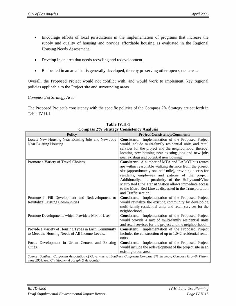
Compass 2% Strategy Area
The Proposed Project’s consistency with the specific policies of the Compass 2% Strategy are set forth in Table IV.H-1.
Table IV.H-1 Compass 2% Strategy Consistency Analysis
Policy Project Consistency/Comments Locate New Housing Near Existing Jobs and New Jobs Near Existing Housing.
Consistent. Implementation of the Proposed Project would include multi-family residential units and retail services for the project and the neighborhood, thereby, locating new housing near existing jobs and new jobs near existing and potential new housing.
Promote a Variety of Travel Choices Consistent. A number of MTA and LADOT bus routes are within reasonable walking distance from the project site (approximately one-half mile), providing access for residents, employees and patrons of the project. Additionally, the proximity of the Hollywood/Vine Metro Red Line Transit Station allows immediate access to the Metro Red Line as discussed in the Transportation and Traffic section.
Promote In-Fill Development and Redevelopment to Revitalize Existing Communities
Consistent. Implementation of the Proposed Project would revitalize the existing community by developing multi-family residential units and retail services for the neighborhood.
Promote Developments which Provide a Mix of Uses Consistent. Implementation of the Proposed Project would provide a mix of multi-family residential units and retail services for the project and the neighborhood.
Provide a Variety of Housing Types in Each Community to Meet the Housing Needs of All Income Levels.
Consistent. Implementation of the Proposed Project includes the construction of up to 1,042 residential rental units.
Focus Development in Urban Centers and Existing Cities.
Consistent. Implementation of the Proposed Project would include the redevelopment of the project site in an existing urban area.
Source: Southern California Association of Governments, Southern California Compass 2% Strategy, Compass Growth Vision, June 2004; and Christopher A Joseph & Associates.

City of Los Angeles April 2006
BLVD 6200 IV.H. Land Use Planning Draft Supplemental Environmental Impact Report Page IV.H-16
As demonstrated, the Proposed Project is consistent with the applicable land use policies of the Compass 2% Strategy.
Hollywood Community Plan
Land Use Designation
The Community Plan is part of the Land Use Element of the Citywide General Plan, and sets forth specific land use requirements and required entitlements for Projects in a specific community within the City. The Hollywood Community Plan designates the project site as Regional Center Commercial and Multiple Family, Medium Density and refers to the City of Los Angeles Municipal Code for specific land uses permitted within this designation. Regional Center Commercial land use designation allows for the construction of commercial, parking and high-density multi-family residential uses. The Multiple Family Medium Density land use designation is a residential designation which allows for the construction of multiple family residential uses such as apartments, condominiums, and multiple family housing units. Development of the Proposed Project would include the construction of up to 1,042 residential rental units and approximately 175,000 square feet of retail uses. This type of development would be consistent with the Regional Center Commercial and Multiple Family Medium Density land use designations.
Goals and Policies
The Proposed Project’s consistency with the specific policies of the Hollywood Community Plan are set forth in Table IV.H-2 below.
City of Los Angeles April 2006
BLVD 6200 IV.H. Land Use Planning Draft Supplemental Environmental Impact Report Page IV.H-17
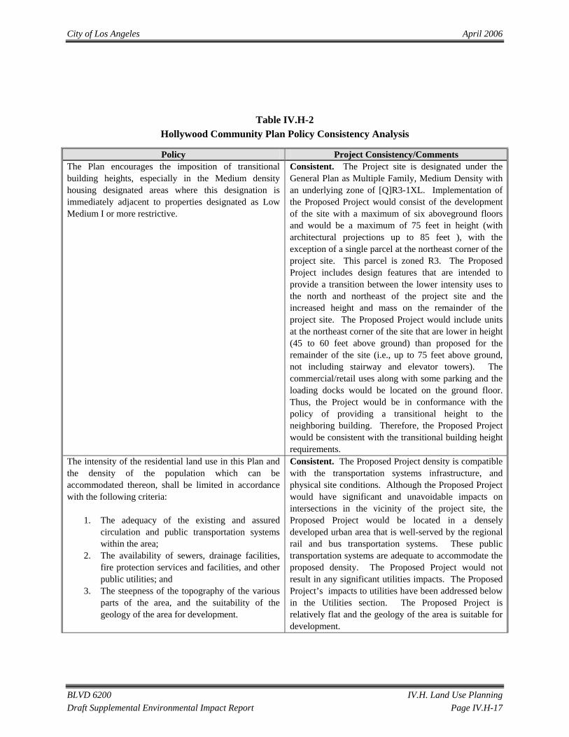
Table IV.H-2 Hollywood Community Plan Policy Consistency Analysis
Policy Project Consistency/Comments The Plan encourages the imposition of transitional building heights, especially in the Medium density housing designated areas where this designation is immediately adjacent to properties designated as Low Medium I or more restrictive.
Consistent. The Project site is designated under the General Plan as Multiple Family, Medium Density with an underlying zone of [Q]R3-1XL. Implementation of the Proposed Project would consist of the development of the site with a maximum of six aboveground floors and would be a maximum of 75 feet in height (with architectural projections up to 85 feet ), with the exception of a single parcel at the northeast corner of the project site. This parcel is zoned R3. The Proposed Project includes design features that are intended to provide a transition between the lower intensity uses to the north and northeast of the project site and the increased height and mass on the remainder of the project site. The Proposed Project would include units at the northeast corner of the site that are lower in height (45 to 60 feet above ground) than proposed for the remainder of the site (i.e., up to 75 feet above ground, not including stairway and elevator towers). The commercial/retail uses along with some parking and the loading docks would be located on the ground floor. Thus, the Project would be in conformance with the policy of providing a transitional height to the neighboring building. Therefore, the Proposed Project would be consistent with the transitional building height requirements.
The intensity of the residential land use in this Plan and the density of the population which can be accommodated thereon, shall be limited in accordance with the following criteria:
1. The adequacy of the existing and assured circulation and public transportation systems within the area;
2. The availability of sewers, drainage facilities, fire protection services and facilities, and other public utilities; and
3. The steepness of the topography of the various parts of the area, and the suitability of the geology of the area for development.
Consistent. The Proposed Project density is compatible with the transportation systems infrastructure, and physical site conditions. Although the Proposed Project would have significant and unavoidable impacts on intersections in the vicinity of the project site, the Proposed Project would be located in a densely developed urban area that is well-served by the regional rail and bus transportation systems. These public transportation systems are adequate to accommodate the proposed density. The Proposed Project would not result in any significant utilities impacts. The Proposed Project’s impacts to utilities have been addressed below in the Utilities section. The Proposed Project is relatively flat and the geology of the area is suitable for development.

City of Los Angeles April 2006
BLVD 6200 IV.H. Land Use Planning Draft Supplemental Environmental Impact Report Page IV.H-18
Table IV.H-2 Hollywood Community Plan Policy Consistency Analysis
Policy Project Consistency/Comments To coordinate the development of Hollywood with that of other parts of the City of Los Angeles and the metropolitan area; to further the development of Hollywood as a major center of population, employment, retail services, and entertainment; and to perpetuate its image as the international center of the motion picture industry.
Consistent. Development of the Proposed Project would support continued development of Hollywood as a regional center because it would provide the retail and commercial density necessary for a regional center It would enhance the image of Hollywood and would perpetuate the image of Hollywood as the international center of the entertainment industry because it would provide the restaurant and other retail uses necessary to support the surrounding theater as well as provide the necessary parking for these establishments. Implementation of the Proposed Project includes the construction of up to 1,042 residential rental units and approximately 175,000 square feet of retail uses. The Proposed Project would be consistent with this objective.
To make provision for the housing required to satisfy the varying needs and desires of all economic segments of the Community, maximizing the opportunity for individual choice.
Consistent. Development of the Proposed Project would include the provision of a substantial number of rental housing units to meet increased demand for housing in the Hollywood Community.
To promote economic well being and public convenience through: a. Allocating and distributing commercial lands for retail, service, and office facilities in quantities and patterns based on accepted planning principles and standards. b. Designating land for industrial development that can be used without determent to adjacent uses of other types, and imposing restrictions on the types and intensities of industrial uses as are necessary to this purpose. c. Encouraging the revitalization of the motion picture industry. d. Recognizing the existing concentration of medical facilities in East Hollywood as a center serving the medical needs of Los Angeles.
Consistent. Development of the Proposed Project would include the construction of up to 1,042 residential rental units and approximately 175,000 square feet of retail uses. The Proposed Project would be consistent with the objective to distribute retail in quantity and pattern to promote economic well being, because the 1,042 rental units will provide the economic base to support the retail uses.
Source: Hollywood Community Plan adopted December 13, 1988.
As demonstrated, the Proposed Project is consistent with the applicable land use policies of the Hollywood Community Plan.

City of Los Angeles April 2006
BLVD 6200 IV.H. Land Use Planning Draft Supplemental Environmental Impact Report Page IV.H-19
Hollywood Redevelopment Plan
Land Use Designation
Under the First Amendment to the Hollywood Redevelopment Plan, the land use designations of the Hollywood Redevelopment Plan were updated to conform with the land use designations of the Hollywood Community Plan and a mechanism was established whereby the land use designations of the Hollywood Redevelopment Plan would automatically conform to any future changes in the Hollywood Community Plan. Because the Proposed project would be consistent with the land use designations and policies of the Hollywood Community Plan, as discussed above, the Proposed Project would be consistent with the land use designations of the Hollywood Redevelopment Plan.
Goals and Policies
The Proposed Project’s consistency with the specific policies of the Hollywood Redevelopment Plan is set forth in Table IV.H-3.
Table IV.H-3 Hollywood Redevelopment Plan Consistency Analysis
Policy Project Consistency/Comments To concentrate high intensity and/or density development in areas with reasonable proximity or direct access to high capacity transportation facilities or which effectively utilize transportation demand management programs.
Consistent. A number of MTA and LADOT bus routes are within reasonable walking distance from the project site (approximately one-half mile), providing access for residents, employees and patrons of the project. Additionally, the proximity of the Hollywood/Vine Metro Red Line Transit Station allows immediate access to the Metro Red Line as discussed in the Transportation and Traffic section. The Proposed Project density is compatible with the transportation systems infrastructure, and physical site conditions.
To encourage the development of appropriately designed housing to provide a balance in the community.
Consistent. Implementation of the Proposed Project would enhance the residential character of the neighborhood by including a coherently and consistently designed development of multi-family residential units and retail services for the project and the neighborhood.
Provide adequate parking for new and existing uses. Consistent. The project parking supply will meet or exceed the LAMC requirement for parking. The Proposed Project would include up to 700 spaces to provide replacement parking for Pantages Theater parking presently provided in surface lots located on the project site. Therefore, the Proposed Project would not have a significant impact with respect to parking. The Proposed Project’s impacts to parking are addressed in the Transportation and Traffic section of this EIR.
Source: Hollywood Redevelopment Plan May 1986.
City of Los Angeles April 2006
BLVD 6200 IV.H. Land Use Planning Draft Supplemental Environmental Impact Report Page IV.H-20
In addition, the Proposed Project would represent substantial private investment within the Hollywood Redevelopment Project Area, consistent with the goals of the Hollywood Redevelopment Plan. As demonstrated, the Proposed Project would be consistent with the applicable land use policies of the Hollywood Redevelopment Plan.
Hollywood Signage Supplemental Use District
Ordinance 176,172 established the Hollywood Signage SUD. This ordinance was enacted to acknowledge and promote the continuing contribution of signage to the distinctive aesthetic of Hollywood, as well as to control the blight created by poorly placed, badly designed signs throughout Hollywood. Parts of the project site are located in the Hollywood Signage SUD. The Proposed Project includes a signage program, which would provide approximately 8,000 square feet of signage, including up to seven supergraphic signs on building walls facing Hollywood Boulevard. New signage would be offset by the removal of approximately 5,000 square feet of pole signs and billboards (11 existing pole signs and four billboards) presently located within the project site. The proposed signage would meet the requirements of the Hollywood Signage SUD. No exceptions from the standards of the Hollywood Signage SUD are being requested as part of the Proposed Project. A Project Permit Compliance approval would be obtained from the City to document this consistency. Project signage would be complimentary to and compatible with building architecture. The existing signs, when considered as a group, create visual clutter at the edge of the project site and project an overall impression of disrepair and visual blight. Proposed Project signage would work to eliminate this effect. The Proposed Project would include a Sign Reduction Program as required by Section 9 of the Hollywood Signage SUD.
CRA’s Amended Design for Development for Signs in Hollywood
Proposed signage, including supergraphic signs, would be consistent with the design criteria of the CRA’s Amended Sign DFD.
City of Los Angeles Municipal Code
Zoning Classification
In accordance with Section 12.11 of the City of Los Angeles Planning and Zoning Code, the Proposed Project uses are permitted within the C4 (Commercial) and R3 (Multiple Family Residential) zones. C4 is a commercial zone which allows for the construction of a variety of commercial uses, including retail stores, offices, restaurants, and parking structures. Additionally, pursuant to LAMC, Section 12.22-A.20, high-density multi-family housing uses permitted in the R5 zone (up to one dwelling unit per 200 square feet of lot area) are also permitted in the C4-zoned portions of the project site because the project site is located in an area designated for “Regional Center” uses in the adopted community plan within an approved redevelopment area. R3 is a residential zoning designation which allows for the construction of multiple family residential uses such as apartments, condominiums, and multiple family housing units. Therefore the general use of the site for retail and multi family housing would be consistent with the C4-2D, C4-2D-SN, the [Q]C4-2D-SN, and the [Q]R3-1XL zones. However, the Proposed Project would not

City of Los Angeles April 2006
BLVD 6200 IV.H. Land Use Planning Draft Supplemental Environmental Impact Report Page IV.H-21
be fully consistent with the applicable “D” development limitations and/or “Q” conditions of the applicable zones and the development standards of the R3 zone. Accordingly, the Project Applicant has requested zone changes, height district changes and zone variances. With project approval, project impacts would be less than significant.
Parking Requirement
As described in Section IV.L, Transportation and Traffic, the Planning and Zoning Code requires one parking space for each dwelling unit of less than three habitable rooms, 1.5 parking spaces for each dwelling units of three habitable rooms, and two parking spaces for each dwelling unit of more than three habitable rooms within the Hollywood Redevelopment Project Area. The zoning code also requires 2 spaces per 1,000 square feet of commercial uses within the Hollywood Redevelopment Project Area (LAMC § 12.21-A.4x). Parking supply would exceed City Code requirements and would be provided on the ground floor level and in subterranean levels below each side of the development. Parking supply would be sufficient to accommodate the patrons of the retail uses, the occupants of the residential units, and patrons of the Pantages Theater that presently utilize the surface parking lots that would be removed as part of the Proposed Project. Within the parking supply provided for the Proposed Project, up to 700 spaces would be available for use by theater patrons on event days. Therefore, no zoning inconsistencies would occur and impacts would be less than significant.
CUMULATIVE IMPACTS
Cumulative land use impacts could occur if other related projects in the vicinity of the project site would result in land use impacts in conjunction with the Proposed Project. A total of 75 proposed or approved projects were identified that could potentially contribute to the cumulative effects of the Proposed Project (as listed in Section III. Environmental Setting). Development of the Proposed Project in conjunction with the related projects would result in an intensification of existing prevailing land uses in the project vicinity.
In particular, Related Project No. 58 is similar to the Proposed Project in that it contains residential units and retail uses, along with a hotel, and is located directly south of the project site. Related Project No. 58 (300 apartments, 100 condominiums, 400 hotel rooms, 20,000 square feet of specialty retail uses, and a 30,000 square foot grocery store) is one of the closest in proximity and the most similar of all the related projects. Other adjacent related projects include Related Project No. 56 (a 5,273 square foot restaurant and 5,273 square foot theater), and Related Project No. 57 (a 60 unit CRA adaptive reuse project). All of these projects, in conjunction with the Proposed Project, would represent general intensification of development in this area of Hollywood, and specifically in the vicinity of the Hollywood/Vine Metro Rail Red Line station. This would be a beneficial cumulative impact as major regional and local land use policies encourage concentration of development near transit stations. The Proposed Project would contribute to this beneficial effect.

City of Los Angeles April 2006
BLVD 6200 IV.H. Land Use Planning Draft Supplemental Environmental Impact Report Page IV.H-22
The remainder of the related projects, in conjunction with the Proposed Project, would result in the general intensification of land use and development density in Hollywood. These projects would be required to either generally conform to the zoning and land use designations for each site or be subject to specific findings and conditions which are based on maintaining general conformance with the land use plans applicable to the area. As such, development of the Proposed Project and related projects is not anticipated to substantially conflict with the intent of the City’s General Plan regarding the future development of Hollywood, or with other land use regulations required to be consistent with the General Plan, such as the Hollywood Redevelopment Plan and Planning and Zoning Code. Development of the Proposed Project, in conjunction with related projects, would not be expected to result in cumulatively considerable effects with respect to land use regulations.
MITIGATION MEASURES
As the Proposed Project is consistent with existing land use regulations and compatible with adjacent land uses, no mitigation measures are required.
LEVEL OF SIGNIFICANCE AFTER MITIGATION
No significant land use compatibility or consistency impacts would result from the long-term operation of the Proposed Project.