irap star rating upload file...
TRANSCRIPT

iRAP Star Rating Upload File Specification
August 2014
<<Insert image here>>
Document description
RAP-SR-3.3

iRAP Star Rating Upload File Specification | 2
About iRAP
The International Road Assessment Programme (iRAP) is a charity dedicated to saving lives through safer
roads.
iRAP works in partnership with government and non-government organisations to:
Inspect high-risk roads and develop Star Ratings and Safer Roads Investment Plans
Provide training, technology and support that will build and sustain national, regional and local capability
Track road safety performance so that funding agencies can assess the benefits of their investments.
Road Assessment Programmes (RAP) are now active in more than 70 countries throughout Europe, Asia
Pacific, North, Central and South America and Africa.
iRAP is financially supported by the FIA Foundation for the Automobile and Society. Projects receive support
from the World Bank Global Road Safety Facility, automobile associations, regional development banks and
donors.
National governments, automobile clubs and associations, charities, the motor industry and institutions such
as the European Commission also support RAPs in the developed world and encourage the transfer of
research and technology to iRAP. In addition, many individuals donate their time and expertise to support
iRAP.
For more information
For more information on iRAP Star Ratings and Safer Roads Investment Plans contact:
James Bradford
iRAP Global Operations Manager
+44 1256 345 598 (GMT+0)
To find out more about the programme, visit www.irap.org. You can also subscribe to ‘WrapUp’, the iRAP e-newsletter,
by sending a message to [email protected].
© International Road Assessment Programme (iRAP) 2014
iRAP technology including protocols, processes and brands may not be altered or used in any way without the express
written agreement of iRAP.
iRAP is a charity registered in England & Wales under charity number 1140357.
Registered Office: 60 Trafalgar Square, London, WC2N 5DS.
iRAP Star Rating Upload File Specification | 3
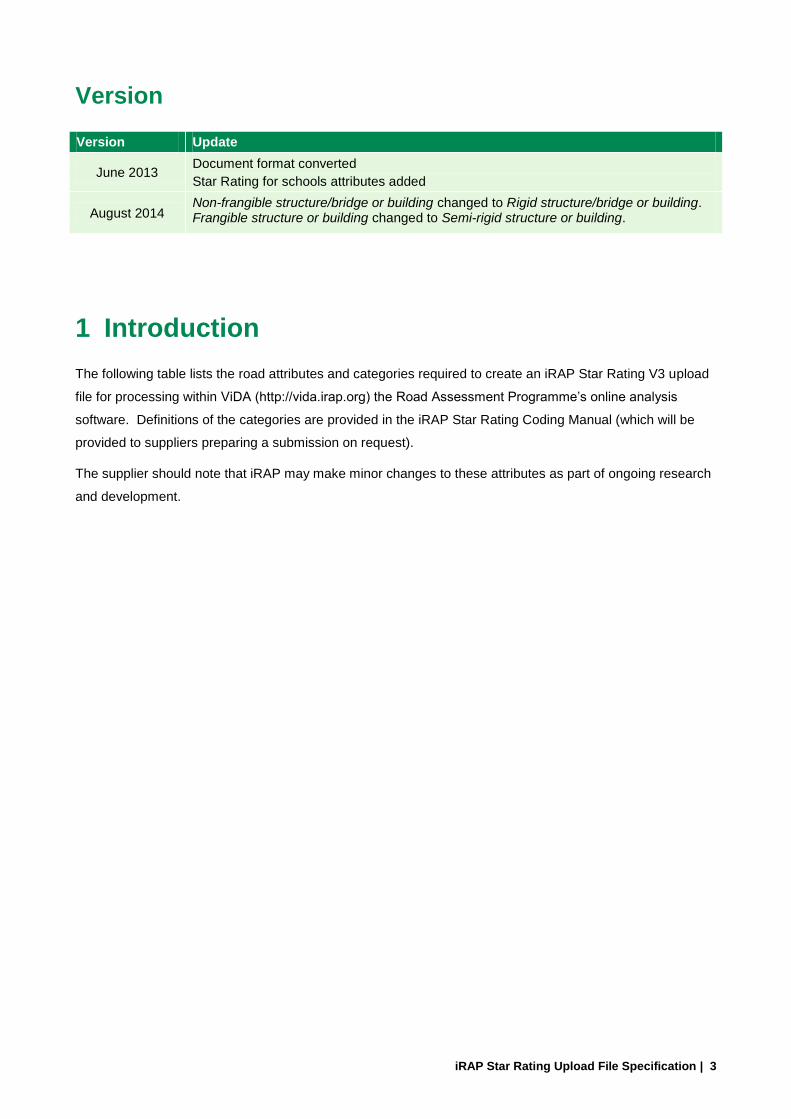
Version
Version Update
June 2013 Document format converted
Star Rating for schools attributes added
August 2014 Non-frangible structure/bridge or building changed to Rigid structure/bridge or building. Frangible structure or building changed to Semi-rigid structure or building.
1 Introduction
The following table lists the road attributes and categories required to create an iRAP Star Rating V3 upload
file for processing within ViDA (http://vida.irap.org) the Road Assessment Programme’s online analysis
software. Definitions of the categories are provided in the iRAP Star Rating Coding Manual (which will be
provided to suppliers preparing a submission on request).
The supplier should note that iRAP may make minor changes to these attributes as part of ongoing research
and development.

iRAP Star Rating Upload File Specification | 4
Table 1: iRAP Star Rating V3 upload file specification
Column Item ID Task Attribute
ID Category
Optional/ required
A 1 Road coding Coder name NA Text Required
B 2 Road coding Coding date NA Text (format dd/mm/yyyy) Required
C 3 Road survey Road survey date NA Text (format dd/mm/yyyy) Required
D 4 Road survey Image reference NA Text Optional
E 5 Road survey Road name NA Text Required
F 6 Road survey Section NA Text Required
F 7 Road survey Distance NA Number (unit km) Required
H 8 Road survey Length NA Number (unit km) Required
I 9 Road survey Latitude NA Number (format decimal degree, WGS84) Required
J 10 Road survey Longitude NA Number (format decimal degree, WGS84) Required
K 11 Road coding Landmark NA Text Optional
L 12 Road coding Comments NA Text Optional
M 13 Road coding Carriageway label 1 Carriageway A of a divided road Required
2 Carriageway B of a divided road
3 Undivided road
4 Carriageway A of a motorcycle facility
5 Carriageway B of a motorcycle facility
N 14 Road coding Upgrade cost 1 Low Required
2 Medium
3 High
O 15 Road coding Motorcycle observed flow 1 None Required
2 1 motorcycle observed
3 2 to 3 motorcycles observed
4 4 to 5 motorcycles observed
5 6 to 7 motorcycles observed
6 8+ motorcycles observed
P 16 Road coding Bicycle observed flow 1 None Required

iRAP Star Rating Upload File Specification | 5
Column Item ID Task Attribute
ID Category
Optional/ required
2 1 bicycle observed
3 2 to 3 bicycles observed
4 4 to 5 bicycles observed
5 6 to 7 bicycles observed
6 8+ bicycles observed
Q 17 Road coding Pedestrian observed flow across the road
1 None Required
2 1 pedestrian crossing observed
3 2 to 3 pedestrians crossing observed
4 4 to 5 pedestrians crossing observed
5 6 to 7 pedestrians crossing observed
6 8+ pedestrians crossing observed
R 18 Road coding Pedestrian observed flow along the road driver-side
1 None Required
2 1 pedestrian along driver-side observed
3 2 to 3 pedestrians along driver-side observed
4 4 to 5 pedestrians along driver-side observed
5 6 to 7 pedestrians along driver-side observed
6 8+ pedestrians along driver-side observed
S 19 Road coding Pedestrian observed flow along the road passenger-side
1 None Required
2 1 pedestrian along passenger-side observed
3 2 to 3 pedestrians along passenger-side observed
4 4 to 5 pedestrians along passenger-side observed
5 6 to 7 pedestrians along passenger-side observed

iRAP Star Rating Upload File Specification | 6
Column Item ID Task Attribute
ID Category
Optional/ required
6 8+ pedestrians along passenger-side observed
T 20 Road coding Land use - driver-side 1 Undeveloped areas Required
2 Farming and agricultural
3 Residential
4 Commercial
5 Not Recorded
6 Educational
7 Industrial and manufacturing
U 21 Road coding Land use - passenger-side 1 Undeveloped areas Required
2 Farming and agricultural
3 Residential
4 Commercial
5 Not Recorded
6 Educational
7 Industrial and manufacturing
V 22 Road coding Area type 1 Rural / open area Required
2 Urban / rural town or village
W 23 Road coding Speed limit 1 <30km/h Required
3 40km/h
5 50km/h
7 60km/h
9 70km/h
11 80km/h
13 90km/h
15 100km/h
17 110km/h
19 120km/h
21 130km/h
23 140km/h

iRAP Star Rating Upload File Specification | 7
Column Item ID Task Attribute
ID Category
Optional/ required
25 ≥150km/h
31 <20mph
33 30mph
35 40mph
37 50mph
39 60mph
41 70mph
43 80mph
45 ≥90mph
X 24 Road coding Motorcycle speed limit 1 <30km/h Optional
3 40km/h
5 50km/h
7 60km/h
9 70km/h
11 80km/h
13 90km/h
15 100km/h
17 110km/h
19 120km/h
21 130km/h
23 140km/h
25 ≥150km/h
31 <20mph
33 30mph
35 40mph
37 50mph
39 60mph
41 70mph
43 80mph
45 ≥90mph

iRAP Star Rating Upload File Specification | 8
Column Item ID Task Attribute
ID Category
Optional/ required
Y 25 Road coding Truck speed limit 1 <30km/h Optional
3 40km/h
5 50km/h
7 60km/h
9 70km/h
11 80km/h
13 90km/h
15 100km/h
17 110km/h
19 120km/h
21 130km/h
23 140km/h
25 ≥150km/h
31 <20mph
33 30mph
35 40mph
37 50mph
39 60mph
41 70mph
43 80mph
45 ≥90mph
Z 26 Road coding Differential speed limits 1 Not present Required
2 Present
AA 27 Road coding Median type 1 Safety barrier - metal Required
2 Safety barrier - concrete
3 Physical median width ≥ 20.0m
4 Physical median width ≥ 10.0m to < 20.0m
5 Physical median width ≥ 5.0m to < 10.0m

iRAP Star Rating Upload File Specification | 9
Column Item ID Task Attribute
ID Category
Optional/ required
6 Physical median width ≥ 1.0m to < 5.0m
7 Physical median width ≥ 0m to < 1.0m
8 Continuous central turning lane
9 Flexipost
10 Central hatching (>1m)
11 Centre line
12 Safety barrier - motorcycle friendly
13 One way
14 Wide centre line (0.3m to 1m)
15 Safety barrier - wire rope
AB 28 Road coding Centreline rumble strips code 1 Not present Required
2 Present
AC 29 Road coding Roadside severity - driver-side distance
1 0 to <1m Required
2 1 to <5m
3 5 to <10m
4 ≥ 10m
AD 30 Road coding Roadside severity - driver-side object
1 Safety barrier - metal Required
2 Safety barrier - concrete
3 Safety barrier - motorcycle friendly
4 Safety barrier - wire rope
5 Aggressive vertical face
6 Upwards slope - (15° to 75°)
7 Upwards slope - (>= 75°)
8 Deep drainage ditch
9 Downwards slope (> -15°)
10 Cliff
11 Tree ≥ 10cm
12 Sign, post or pole ≥ 10cm

iRAP Star Rating Upload File Specification | 10
Column Item ID Task Attribute
ID Category
Optional/ required
13 Rigid structure/bridge or building
14 Semi-rigid structure or building
15 Unprotected safety barrier end
16 Large boulders ≥ 20cm high
17 No object
AE 31 Road coding Roadside severity - passenger-side distance
1 0 to <1m Required
2 1 to <5m
3 5 to <10m
4 ≥10m
AF 32 Road coding Roadside severity - passenger-side object
1 Safety barrier - metal Required
2 Safety barrier - concrete
3 Safety barrier - motorcycle friendly
4 Safety barrier - wire rope
5 Aggressive vertical face
6 Upwards slope - (15° to 75°)
7 Upwards slope - (>= 75°)
8 Deep drainage ditch
9 Downwards slope (> -15°)
10 Cliff
11 Tree ≥ 10cm
12 Sign, post or pole ≥ 10cm
13 Rigid structure/bridge or building
14 Semi-rigid structure or building
15 Unprotected safety barrier end
16 Large boulders ≥ 20cm high
17 No object
AG 33 Road coding Shoulder rumble strips 1 Not present Required
2 Present

iRAP Star Rating Upload File Specification | 11
Column Item ID Task Attribute
ID Category
Optional/ required
AH 34 Road coding Paved shoulder - driver-side 1 Wide (≥ 2.4m) Required
2 Medium (≥ 1.0m to < 2.4m)
3 Narrow (≥ 0m to < 1.0m)
4 None
AI 35 Road coding Paved shoulder - passenger-side
1 Wide (≥ 2.4m) Required
2 Medium (≥ 1.0m to < 2.4m)
3 Narrow (≥ 0m to < 1.0m)
4 None
AJ 36 Road coding Intersection type 1 Merge lane Required
2 Roundabout
3 3-leg unsignalised with protected turn lane
4 3-leg unsignalised with no protected turn lane
5 3-leg signalised with protected turn lane
6 3-leg signalised with no protected turn lane
7 4-leg unsignalised with protected turn lane
8 4-leg unsignalised with no protected turn lane
9 4-leg signalised with protected turn lane
10 4-leg signalised with no protected turn lane
11 Do not use this code
12 None
13 Railway Crossing - passive (signs only)
14 Railway Crossing - active (flashing lights / boom gates)
15 Median crossing point - informal
16 Median crossing point - formal

iRAP Star Rating Upload File Specification | 12
Column Item ID Task Attribute
ID Category
Optional/ required
17 Mini roundabout
AK 37 Road coding Intersection channelisation 1 Not present Required
2 Present
AL 38 Road coding Intersecting road volume 1 ≥15,000 vehicles Required
2 10,000 to 15,000 vehicles
3 5,000 to 10,000 vehicles
4 1,000 to 5,000 vehicles
5 100 to 1,000 vehicles
6 1 to 100 vehicles
7 Not applicable
AM 39 Road coding Intersection quality 1 Adequate Required
2 Poor
3 Not applicable
AN 40 Road coding Property access points 1 Commercial Access 1+ Required
2 Residential Access 3+
3 Residential Access 1 or 2
4 None
AO 41 Road coding Number of lanes 1 One Required
2 Two
3 Three
4 Four or more
5 Two and one
6 Three and two
AP 42 Road coding Lane width 1 Wide (≥ 3.25m) Required
2 Medium (≥ 2.75m to < 3.25m)
3 Narrow (≥ 0m to < 2.75m)
AQ 43 Road coding Curvature 1 Straight or gently curving Required
2 Moderate
3 Sharp
4 Very sharp

iRAP Star Rating Upload File Specification | 13
Column Item ID Task Attribute
ID Category
Optional/ required
AR 44 Road coding Quality of curve 1 Adequate Required
2 Poor
3 Not applicable
AS 45 Road coding Grade 1 >= 0% to <7.5% Required
2 Not applicable
3 Not applicable
4 >= 7.5% to <10%
5 >= 10%
AT 46 Road coding Road condition 1 Good Required
2 Medium
3 Poor
AU 47 Road coding Skid resistance / grip 1 Sealed - adequate Required
2 Sealed - medium
3 Sealed - poor
4 Unsealed - adequate
5 Unsealed - poor
AV 48 Road coding Delineation 1 Adequate Required
2 Poor
AW 49 Road coding Street lighting 1 Not present Required
2 Present
AX 50 Road coding Pedestrian crossing - inspected road
1 Grade separated facility Required
2 Signalised with refuge
3 Signalised without refuge
4 Unsignalised marked crossing with refuge
5 Unsignalised marked crossing without a refuge
6 Refuge only
7 No facility
14 Unsignalised raised marked crossing

iRAP Star Rating Upload File Specification | 14
Column Item ID Task Attribute
ID Category
Optional/ required
with refuge
15 Unsignalised raised marked crossing without refuge
16 Raised unmarked crossing with refuge
17 Raised unmarked crossing without refuge
AY 51 Road coding Pedestrian crossing quality 1 Adequate Required
2 Poor
3 Not applicable
AZ 52 Road coding Pedestrian crossing facilities - side road
1 Grade separated facility Required
2 Signalised with refuge
3 Signalised without refuge
4 Unsignalised marked crossing with refuge
5 Unsignalised marked crossing without a refuge
6 Refuge only
7 No facility
14 Unsignalised raised marked crossing with refuge
15 Unsignalised raised marked crossing without refuge
16 Raised unmarked crossing with refuge
17 Raised unmarked crossing without refuge
BA 53 Road coding Pedestrian fencing 1 Not present Required
2 Present
BB 54 Road coding Speed management / traffic calming
1 Not present Required
2 Present
BC 55 Road coding Vehicle parking 1 None Required

iRAP Star Rating Upload File Specification | 15
Column Item ID Task Attribute
ID Category
Optional/ required
2 One side
3 Two sides
BD 56 Road coding Sidewalk - driver-side 1 Physical barrier Required
2 Non-physical separation ≥ 3.0m
3 Non-physical separation 1.0m to <3.0m
4 Non-physical separation 0m to <1.0m
5 None
6 Informal path ≥ 1.0m
7 Informal path 0m to <1.0m
BE 57 Road coding Sidewalk - passenger-side 1 Physical barrier Required
2 Non-physical separation ≥ 3.0m
3 Non-physical separation 1.0m to <3.0m
4 Non-physical separation 0m to <1.0m
5 None
6 Informal path ≥ 1.0m
7 Informal path 0m to <1.0m
BF 58 Road coding Service road 1 Not present Required
2 Present
BG 59 Road coding Motorcycle facilities 1 Exclusive one way motorcycle path with barrier Required
2 Exclusive one way motorcycle path without barrier
3 Exclusive two way motorcycle path with barrier
4 Exclusive two way motorcycle path without barrier
5 Inclusive motorcycle lane on roadway
6 None
BH 60 Road coding Bicycle facility 1 Off-road path with barrier Required
2 Off-road path
3 On-road lane

iRAP Star Rating Upload File Specification | 16
Column Item ID Task Attribute
ID Category
Optional/ required
4 None
5 Extra wide outside (≥4.2m)
6 Signed shared roadway
7 Shared use path
BI 61 Road coding Roadworks 1 No road works Required
2 Minor road works in progress
3 Major road works in progress
BJ 62 Road coding Sight distance 1 Adequate Required
2 Poor
BK 63 Supporting data Vehicle flow (AADT) NA NA Required
BL 64 Supporting data Motorcycle % 1 Not recorded Required
2 0%
3 1% - 5%
4 6% - 10%
5 11% - 20%
6 21% - 40%
7 41% - 60%
8 61% - 80%
9 81% - 99%
10 100%
BM 65 Supporting data Pedestrian peak hour flow across the road
1 0 Required
2 1 to 5
3 6 to 25
4 26 to 50
5 51 to 100
6 101 to 200
7 201 to 300
8 301 to 400
9 401 to 500

iRAP Star Rating Upload File Specification | 17
Column Item ID Task Attribute
ID Category
Optional/ required
10 501 to 900
11 900+
BN 66 Supporting data Pedestrian peak hour flow along the road driver-side
1 0 Required
2 1 to 5
3 6 to 25
4 26 to 50
5 51 to 100
6 101 to 200
7 201 to 300
8 301 to 400
9 401 to 500
10 501 to 900
11 900+
BO 67 Supporting data Pedestrian peak hour flow along the road passenger-side
1 0 Required
2 1 to 5
3 6 to 25
4 26 to 50
5 51 to 100
6 101 to 200
7 201 to 300
8 301 to 400
9 401 to 500
10 501 to 900
11 900+
BP 68 Supporting data Bicycle peak hour flow 1 none Required
2 1 to 5
3 6 to 25
4 26 to 50

iRAP Star Rating Upload File Specification | 18
Column Item ID Task Attribute
ID Category
Optional/ required
5 51 to 100
6 101 to 200
7 201 to 300
8 301 to 400
9 401 to 500
10 501 to 900
11 900+
BQ 69 Supporting data Operating Speed (85th percentile)
1 <30km/h Required
2 35km/h
3 40km/h
4 45km/h
5 50km/h
6 55km/h
7 60km/h
8 65km/h
9 70km/h
10 75km/h
11 80km/h
12 85km/h
13 90km/h
14 95km/h
15 100km/h
16 105km/h
17 110km/h
18 115km/h
19 120km/h
20 125km/h
21 130km/h
22 135km/h

iRAP Star Rating Upload File Specification | 19
Column Item ID Task Attribute
ID Category
Optional/ required
23 140km/h
24 145km/h
25 ≥150km/h
31 <24mph
32 25mph
33 30mph
34 35mph
35 40mph
36 45mph
37 50mph
38 55mph
39 60mph
40 65mph
41 70mph
42 75mph
43 80mph
44 85mph
45 ≥90mph
BR 70 Supporting data Operating Speed (mean) 1 <30km/h Required
2 35km/h
3 40km/h
4 45km/h
5 50km/h
6 55km/h
7 60km/h
8 65km/h
9 70km/h
10 75km/h
11 80km/h
12 85km/h

iRAP Star Rating Upload File Specification | 20
Column Item ID Task Attribute
ID Category
Optional/ required
13 90km/h
14 95km/h
15 100km/h
16 105km/h
17 110km/h
18 115km/h
19 120km/h
20 125km/h
21 130km/h
22 135km/h
23 140km/h
24 145km/h
25 ≥150km/h
31 <24mph
32 25mph
33 30mph
34 35mph
35 40mph
36 45mph
37 50mph
38 55mph
39 60mph
40 65mph
41 70mph
42 75mph
43 80mph
44 85mph
45 ≥90mph
BS 71 Analysis Roads that cars can read 1 Meets specification Optional
2 Does not meet specification

iRAP Star Rating Upload File Specification | 21
Column Item ID Task Attribute
ID Category
Optional/ required
BT 72 Analysis Car Star Rating Policy Target 1 1 Star Optional
2 2 Star
3 3 Star
4 4 Star
5 5 Star
6 Not applicable
BU 73 Analysis Motorcycle Star Rating Policy Target
1 1 Star Optional
2 2 Star
3 3 Star
4 4 Star
5 5 Star
6 Not applicable
BV 74 Analysis Pedestrian Star Rating Policy Target
1 1 Star Optional
2 2 Star
3 3 Star
4 4 Star
5 5 Star
6 Not applicable
BW 75 Analysis Bicycle Star Rating Policy Target
1 1 Star Optional
2 2 Star
3 3 Star
4 4 Star
5 5 Star
6 Not applicable
BX 76 Analysis Annual Fatality Growth Multiplier
NA Required
BY 77 Road coding School zone warning 1 School zone flashing beacons Required
2 School zone static signs or road

iRAP Star Rating Upload File Specification | 22
Column Item ID Task Attribute
ID Category
Optional/ required
markings
3 No school zone warning
4 Not applicable (no school at the location)
BZ 78 Road coding School zone crossing supervisor
1 School zone crossing supervisor present at school start and finish times Required
2 School zone crossing supervisor not present
3 Not applicable (no school at the location)