investigations at castronovo di sicilia
TRANSCRIPT
1
INVESTIGATIONS at CASTRONOVO di SICILIA Results and Future, 2015
Introduction
The period of history being studied by the present researchers is the 6th to 12th century AD,
and the subject of interest is the social and economic change brought about by successive
changes in regime in Sicily (FIG 1). Europe during the period concerned was subject to a
wide range of ideological confrontations: Christian factions drove the Carolingian empire in
the north (8/9th century) and the Byzantine empire (6/12th century) in the east. Islamic empires
were established by the Umayyads in the 8th century, the Abbasids in the 9th and the Fatimids
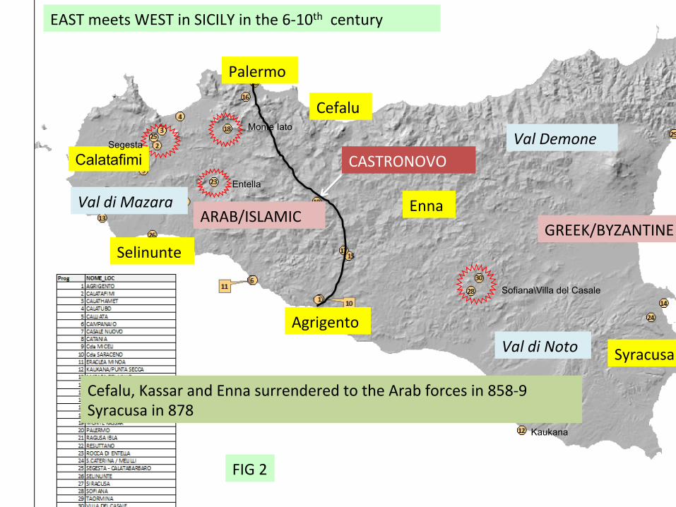
in the 10th. Sicily lies at the centre of this zone of confrontation, with the western part of the
island being the more subject to Arab influence and the eastern largely remaining aligned
with Byzantine Greece (FIG 2).
Castronovo di Sicilia lies in the centre of the island at the headwaters of the Platani and Torto
rivers that flow respectively south and north, and halfway along the line of the current road
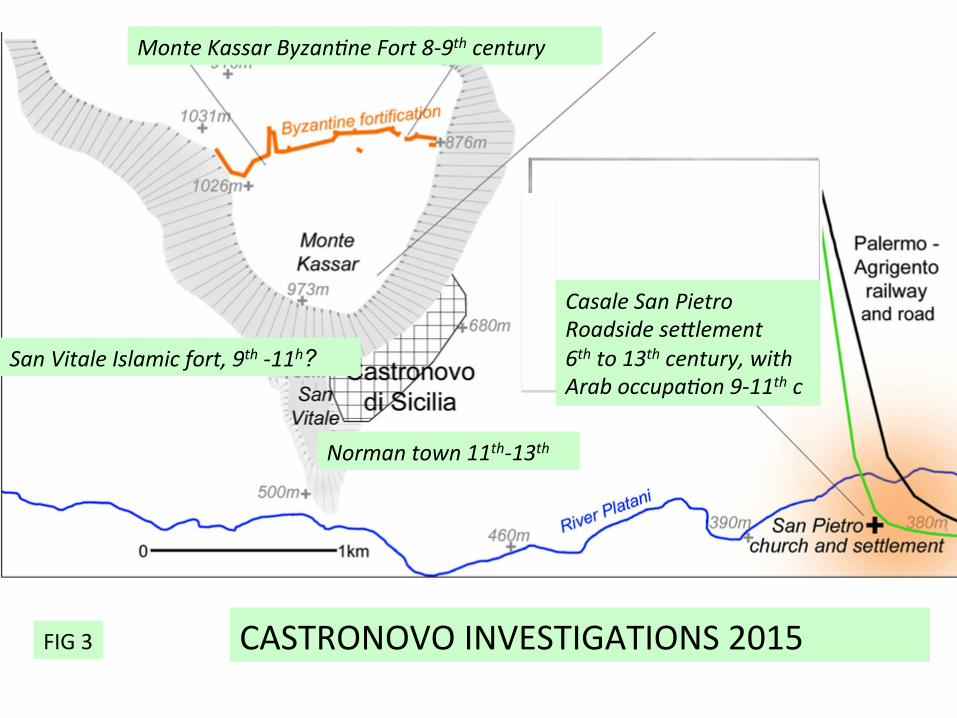
and railway that connects Agrigento and Palermo. Three principal areas of archaeological
interest have been defined: at Monte Kassar (1050m) are the remains of a late Byzantine
defensive system dated to the 8/9th century; at San Vitale are the ruins of a later stronghold
created by Arabs in the 9th century, in which most surviving monuments are Norman (11/12th
century); and in the plain beside the River Platani at Casale San Pietro is an extensive
Byzantine settlement of the 5th to 7th century, and a 9-11th century Arab settlement focused on
the historic building at San Pietro itself (FIG 3).
Investigations in 2014
These centres were defined by background research and endorsed by the 2014 and 2015
evaluation seasons. In 2014 at Monte Kassar, a series of buildings was located on the summit
of Monte Kassar by magnetometry and a drystone house built on the inside of the defensive
wall was excavated on the south side of a point previously investigated by Agata Villa (FIG
4). This was the first certain indication that the Byzantine fortress was occupied (FIG 5, 6, 7).
In the same year the area on the plain to the west of San Pietro was surveyed by surface
collection and magnetometry, the results of which suggested a dense occupation from the 5th
to the 13th century. However test excavation showed that this area had been subject to deep

2
destruction and dispersal of materials due to ploughing. All three major centres were further
defined in 2015.
Investigations in 2015
Monte Kassar, 8th-9th century Byzantine fortress
On Monte Kassar, the area examined lay on the north side of Agata Villa’s excavations. It
proved to be an open yard created by levelling prior to the construction of the defensive wall.
Standing on this yard were drystone walls of two buildings. These had few diagnostic
features, but are thought to be closely associated with the defensive wall, both in time and
purpose. At this point, a three-way set of steps had been incorporated in the body of the wall,
and a layer of tread leading to them suggested intensive use over a considerable period (FIG
8, 9).
The previous excavations by Agata Villa had contacted a spread of plaster thought to have
underlaid the Byzantine features. The plaster was encountered on the west side of a
rudimentary wall assigned a date in the Archaic period. Exploration of this plaster floor over a
more extensive area showed that it had been laid in a semi-circular hollow cut through the
blocky sandstone natural. There was no wall associated with this semi-circular cut, but a
shallow scoop was located in the centre of the plaster spread containing a rich assemblage of
archaic pottery and lumps of pure lime. This may have been intended as a hearth but there
were few signs of burning. The surface of the blocky sandstone natural further west had been
cut by two other features that cut each other. They were curved and narrow and the example
to the north was sectioned to natural rock and proved to have thick-walled Archaic pottery in
its upper fill. These features elongated resembled storage pits (souterrains) known in later
Celtic cultures (FIG 10).
Casale San Pietro: Byzantine period, 5-7th century
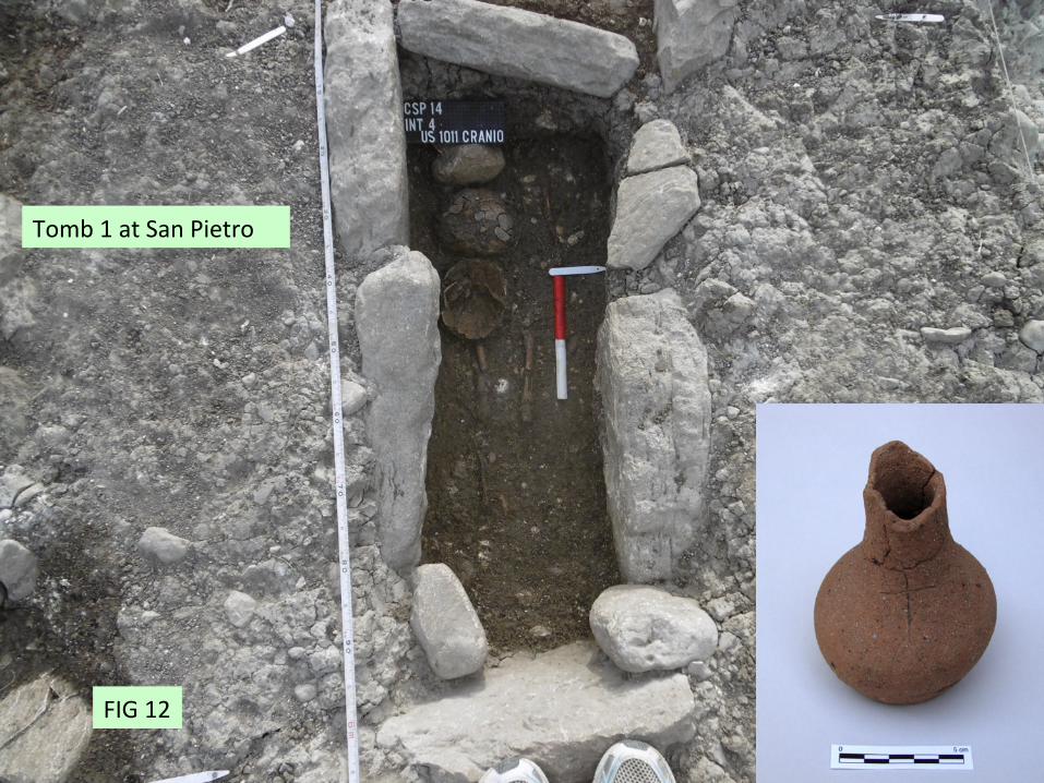
The zone indicated by surface finds as belonging to the Byzantine village was explored in
2014 when two 6/7th child burials and an 11th century hearth were excavated (FIG 12). These
were cut into or situated just above the natural concreted gravel of the flood plain. In 2015
two additional test excavations were carried out to the south of the church. In the area most
distant from the church (Int 8) recent ploughsoil lay on natural gravel 0.4m from the surface.
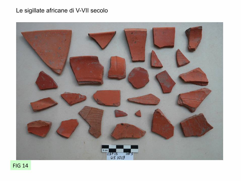
The area nearest the church (Int 6) contained a wall built of well mortared lozenge-shaped
river cobbles, sealed by a spread of tiles and rubble at a the base of the recent ploughsoil (FIG

3
13). Pottery associated with the wall suggested occupation between the 5th and 7th century
(FIG 14). Examination of areas of mortar extruding from the wall showed that its elevation,
which stood to 0.53m, mainly comprised foundations set in mortar laid in a U-shaped trench
(al sacco). The plough had therefore removed all traces of floors or exterior surfaces of
activity and truncated the wall to its foundations. A row of stones displaced from the wall
remained in formation. It can be noted that not only is the ploughing very deep (at least 0.4 m
from present ground level) but powerful enough to displace whole courses of mortared wall
sideways. The modern ploughs drawn by caterpillar tractors are quite capable of doing this,
suggesting that the most destructive levelling took place recently.
Casale San Pietro: the Arab period, 9-11th century
Intervention 5 at Casale San Pietro was situated west of the church building at a place
designed to pick up the deepest sequence that was extant. It began as a 2x2 test excavation
which cut through a metalled trackway and a ploughsoil of medieval date onto a layer of
rubble that featured large sherds of 11/12th century pottery. Following this promising start, the
trench was extended to a length of 6m in a northerly direction. The layer of rubble remained
strong and at the north end was found by excavation to have concealed a fine wall built in
ashlar, later modified by another coarser wall inserted at an imprecise right angle (FIG 15).
The wall therefore had two phases. The original wall had been constructed in a foundation
trench. The contexts were well stratified and rich in ceramics suggesting a coherent sequence
of sealed assemblages from the 9th to the 12th century (FIG 16, 17). Beneath the occupation
zone of the wall lie the tiles of the 5-7th century Byzantine village. The 8th century was
missing.
This is the first certain sighting of a well-stratified sequence with culturally Islamic pottery of
the 9-11th century in Sicily. The evaluation indicated that survival was potentially very good:
the building that was contacted survived to a height of 0.65m above its contemporary ground
level. The top of this surviving structure was encountered 0.5m below the present surface of
the ground, and 1.80m below the present church floor. Other walls showing in the
neighbourhood of the Casale buildings or embedded in its fabric could also be survivors from
the Arab phase. It can be surmised that about 2.5m of stratified deposits from the middle ages
(9th to 13th century) survive under the church floor in the Casale San Pietro mound.
Synthesis and future

4
At Monte Kassar we have obtained new information on the use of the fortress and its date.
There is little doubt that it represents a serious investment by the Byzantine state to defend the
island at a key point in the road network during the 8th century, and that this defence became
ineffective in the 9th century. These dates, dependent largely on ceramics, are consistent with
the archaeological evidence for military quarters occupied by a resident garrison in the 8th
century, and the eventual surrender of the site in the mid 9th century as implied by the written
documents. The interior of Monte Kassar has produced little surface material, so that the
garrison appears to be largely quartered near the wall, occupied in a watching role especially
to north, east and west. Topographic survey suggests that a number of other towers remain to
be discovered especially in the area of the northern approaches. Further exploration can be
conducted by magnetometry, which is known to work well. But the future of this site lies not
so much in more research as in its development as one of the most important and most
neglected monuments in Sicily. A priority would be the commissioning of a conservation and
display plan.
The investigations at Casale San Pietro show that in the fields and orchards the destruction of
the Byzantine and later occupation has been very thorough and virtually nothing remains
above its contemporary ground level. However, negative features, such as furnaces, kilns and
stone foundations give strong signals to magnetometry; much of the area of occupation could
be mapped by this means, even if dating evidence could remain elusive.
By contrast, the area within and round the Casale San Pietro historic building cluster is rich
and deep and far from destroyed. This area not only has the potential to reveal the
architecture and economy of Islamic Sicily, but is probably the only place where the
Byzantine ‘agri-town’ has not been destroyed by ploughing. For these reasons, a programme
of research, conservation and public reception is highly desirable. The area still free of
buildings is large enough to answer the bulk of the research questions asked today. On the
other hand the dumping of large amounts of Byzantine or earlier building stone, observed by
the directors at first hand, including fragments of a large column, shows that the land is under
continual pressure from farming, road-widening and redevelopment.
We now have a continuous ceramic type-series from the 5th century to the 13th and are ready
to draw a complete narrative from Castronovo di Sicilia as it experienced successive
Byzantine, Arab and Norman regimes. Since the focus of settlement shifted, the investigation
will continue to be applied at the three main sites at Castronovo. At the same time we are
examining the assemblages from 14 other unpublished distributed over the Sicilian island, so
5
will eventually be in a position to report on the experience of the island as a whole and its
changing contact zone.
Summary
Historic Castronovo is on the verge of a new floruit. Its contribution to research in a relatively
unknown period has already been inestimable. Its principal remaining asset is the
unexcavated 9th century and later sequence that undoubtedly remains in and around the
buildings of Casale San Pietro. In conjunction with further research, both here and on Monte
Kassar a dazzling potential for monumentalisation awaits realisation. Its rewards for
Castronovo in terms of increased tourism and identity can be judged as outstanding.
Martin Carver and Alessandra Molinari
23 Sep 2015
LIST of Illustrations
FIG 1: Poster for the end of season talk at Casale San Pietro
FIG 2: Regime change in Sicily, 6th to 11th century
FIG 3: Four centres of activity at Castrronovo: Byzantine fort at Monte Kassar (7/8th century);
Arabic citadel (9/11th century); roadside settlement at Casale San Pietro (5th to 13th century),
including newly discovered Arab settlement 9-11th century; Norman and Medieval town (at
site of present town)
FIG 4: DTM of Monte Kassar showing area of excavation and survey 2014 and 2015
FIG 5: Monte Kassar: Geophysical survey by Helen Goodchild, University of York, showing
possible barrack blocks
FIG 6: Monte Kassar: Excavated house against the inside of the fortress wall, 8th century
FIG 7: Monte Kassar: Byzantine military belt buckle, refurbished, found on the floor of the
house
FIG 8: Monte Kassar: Steps discovered within the fortress wall, looking North
FIG 9: Monte Kassar: digital plan of Byzantine buildings against the fortress wall
FIG 10: Monte Kassar: under the Byzantine fort were traces of a settlement of the Archaic
period (c500BC) with an assemblage of fine wares.
FIG 11: The historic building cluster around the church at Casale San Pietro on the Agrigento-Palermo road with Monte Kassar in the background
FIG 12: Casale San Pietro: excavations in the fields beside the road reveal two children’s
tombs of the 6/7th century. This example included a pottery bottle with incised cross.
6
FIG 13: Casale San Pietro. The fields around the church were severely disturbed by
ploughing, truncating the stone buildings. This wall of a Byzantine (6/7th century) building
was reduced to its foundations.
FIG 14: Casale San Pietro. Excavation of an Arab structure east of the church. Within the
inner angle of the wall is a stone bench.
FIG 15: Casale San Pietro. The sequence above the Arab building, 9th to 21st century
FIG 16: Casale San Pietro. African Red slip of the 5th to 7th century
FIG 17: Casale San Pietro. Islamic pottery of the 9-11th century
FIG 18: Staff and students from the Universities of York and Rome Tor Vergata at Monte
Kassar
FIG 19: On the steps at Mont Kassar; staff and students of Rome and York with director
Alessandra Molinari and inspector of the Palermo Soprintendenza Stefano Vassalo.
FIG 20: Madeleine Hummler, Jasmine and Fiona with Conker.
Fig 1
Calatafimi Segesta
Monte Iato
Entella
Sofiana\Villa del Casale
Kaukana
Cefalu, Kassar and Enna surrendered to the Arab forces in 858-‐9 Syracusa in 878
CASTRONOVO
Agrigento
Palermo
Enna
Selinunte
EAST meets WEST in SICILY in the 6-‐10th century
Syracusa
Val di Mazara
Val Demone
Val di Noto
GREEK/BYZANTINE ARAB/ISLAMIC
Cefalu
FIG 2
Monte Kassar Byzan5ne Fort 8-‐9th century
Norman town 11th-‐13th
CASTRONOVO INVESTIGATIONS 2015
Casale San Pietro Roadside seDlement 6th to 13th century, with Arab occupa5on 9-‐11th c
San Vitale Islamic fort, 9th -‐11h?
FIG 3

Line of defensive wall
ExcavaWon and survey 2014 & 2015
Monte Kassar – a ByzanWne stronghold of the 7-‐8th century
MONTE KASSAR
N
FIG 4

Barracks?
ExcavaWons
MONTE KASSAR
FIG 5
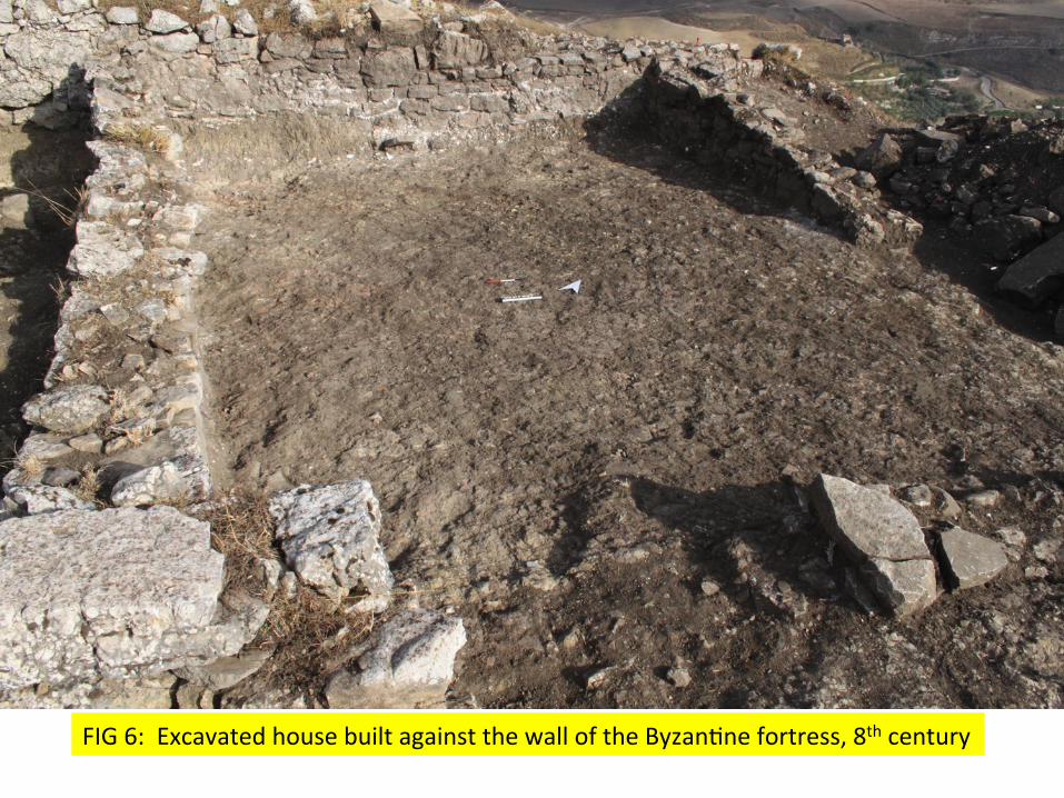
FIG 6: Excavated house built against the wall of the ByzanWne fortress, 8th century
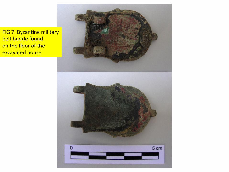
FIG 7: ByzanWne military belt buckle found on the floor of the excavated house
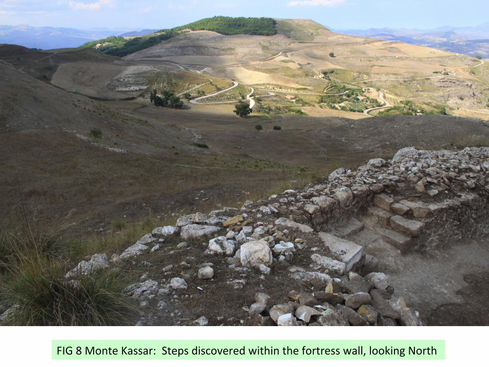
FIG 8 Monte Kassar: Steps discovered within the fortress wall, looking North
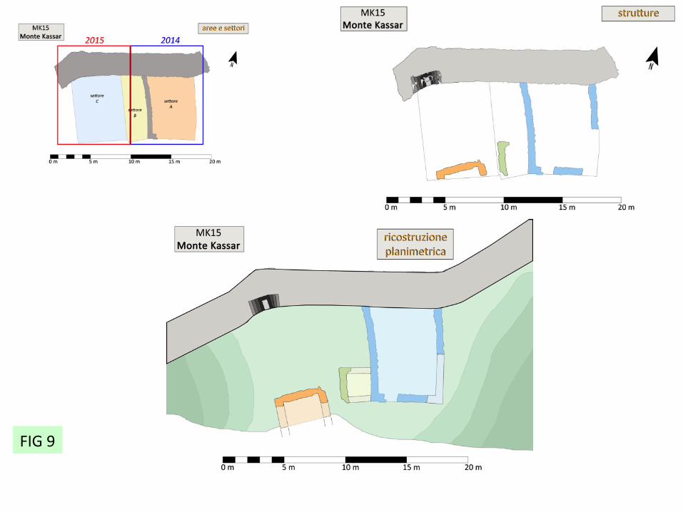
FIG 9

Fig 10

FIG 11: The historic buildings at Casale San Pietro on the Agrigento-‐Palermo road. Monte Kassar in the background
Tomb 1 at San Pietro
FIG 12

FIG 13
Le sigillate africane di V-VII secolo
FIG 14

FIG 15

SECTION through Int 5
1000 aratura 21st c
1004 strada 18th c
1003 aratura 11/12th c
1005 crollo 10/11th c
1016 tegole, 9/11th c
1019 piano d’uso 10th c Muro arabo
Trincea di fondazione FIG 16
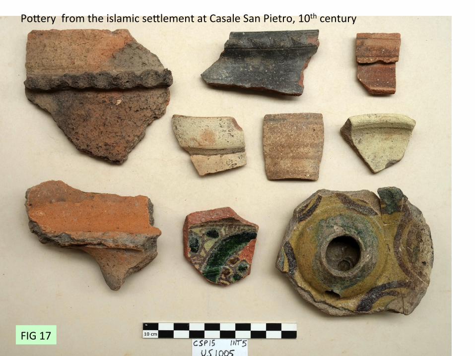
Pobery from the islamic seblement at Casale San Pietro, 10th century
FIG 17

FIG 18
FIG 19
FIG 20