investigation of blowout and fire eugene island block 284
TRANSCRIPT

OCS ReportMMS 2001-084
Investigation of Blowout and FireEugene Island Block 284OCS-G 0991 Well A-13March 1, 2001
Gulf of MexicoOff the Louisiana Coast
U.S. Department of the InteriorMinerals Management ServiceGulf of Mexico OCS Regional Office

OCS ReportMMS 2001-084
Investigation of Blowout and FireEugene Island Block 284OCS-G 0991 Well A-13March 1, 2001
Gulf of MexicoOff the Louisiana Coast
Tom BaseyJohn McCarrollMarty RinaudoBuddy Stewart
U.S. Department of the InteriorMinerals Management Service New OrleansGulf of Mexico OCS Regional Office August 2001

ii
Contents
Investigation and ReportAuthority, 1Procedures, 1
IntroductionBackground, 4Brief Description of Accident, 4
FindingsActivities Prior to Loss of Well Control, 5Loss of Well Control, 8Attempts to Stop Well Flow, 8Evacuation and Rescue, 9Subsequent Activities, 10Damages, 11Cement Operations, 11Management, 13
ConclusionsThe Accident, 15Contributing Causes, 15
RecommendationsSafety Alert, 17Study, 18
AppendixAttachment 1, Location of Leases OCS-G 0987 Eugene Island Block 273 (surface location)
and OCS-G 0991 Eugene Island 284 (bottom hole location) Attachment 2, Eugene Island Block 273, Well A-13 wellbore schematicAttachment 3, Slip-on wellhead schematic and +10 valve schematicAttachment 4, Flow at +10 valve and fire monitors on locationAttachment 5, Flow at +10 valveAttachment 6, Platform/rig on fireAttachment 7, Damage to platform and rig resulting from fireAttachment 8, Installation of diverter system and BOP stack

1
Investigation and Report
Authority An uncontrolled flow on Well A-13, resulting in a blowout and fire, occurred
aboard the rig Ensco 51 during drilling operations on Forest Oil
Corporation’s Lease OCS-G 0987 Platform A, Eugene Island Block 273, in
the Gulf of Mexico, offshore the State of Louisiana, on March 1, 2001, at
approximately 0100 hours. The bottom hole location of Well A-13 is Lease
OCS-G 0991, Eugene Island Block 284. Pursuant to Section 208, Subsection
22(d), (e), and (f), of the Outer Continental Shelf (OCS) Lands Act, as
amended in 1978, and the Department of the Interior Regulations
30 CFR 250, the Minerals Management Service (MMS) is required to
investigate and prepare a public report of this accident. By memorandum
dated March 1, 2001, the following MMS personnel were named to the
investigation panel:
Buddy Stewart, Lafayette, Louisiana (Chairman)
John McCarroll, Houma, Louisiana
Tom Basey, Lafayette, Louisiana
Marty Rinaudo, Lafayette, Louisiana
Procedures On the morning of March 4, 2001, personnel (two engineers and two
inspectors) from the MMS Lafayette District conducted an aerial
reconnaissance of the platform and drilling rig. The MMS personnel then
proceeded to Eugene Island Block 292, Platform B, where Forest personnel
had set up their offshore command center. The MMS personnel were able to
interview Forest’s Representative and several Ensco personnel. Later that
day, Forest relocated their offshore command center to the dynamically

2
positioned D/B 50, which had been brought on location to be used as a
staging/support vessel. MMS personnel monitored the response effort from
the D/B 50.
On March 5, 2001, two MMS engineers returned to the incident location for
an update on the response effort. The D/B 50 was on location and Forest,
Ensco, and Wild Well Control were continuing operations to assess the site.
MMS personnel were able to interview an additional Ensco person.
On March 16, 2001, an MMS engineer and inspector returned to the incident
location for an update on the response effort.
On April 11, 2001, the Panel Members met at Forest Oil Corporation’s office
in Lafayette, Louisiana, and the following individuals were interviewed:
Brian Roney, Ensco International
David Harper, Ensco International
Billy Whisenhunt, Ensco International
Danny Hawkins, Ensco International
Wayne Hession, Ensco International
On April 25, 2001, the Panel Members met at Forest Oil Corporation’s office
in Lafayette, Louisiana, and the following individuals were interviewed:
Harold Cody, Ensco International
Reggie Howard, BJ Services Jim Steward, Forest Oil Corporation

3
On May 9, 2001, the Panel Members visited Seaboard International in
Lafayette, Louisiana, and examined their wellhead design.
On May 16, 2001, the Panel Members met at Forest Oil Corporation’s office
in Lafayette, Louisiana, and the following individuals were interviewed:
Darin Hebert, Cameron
Ned Shifflett, Forest Oil Corporation
Cecil Colwell, Forest Oil Corporation
The panel members met at various times throughout the investigative effort
and, after having considered all of the information, produced this report.
4
Introduction
Background Lease OCS-G 0991 covers approximately 5,000 acres and is located in
Eugene Island Block 284, Gulf of Mexico, off the Louisiana coast. (For
lease location, see Attachment 1.) The lease was issued effective June 1,
1962, and Forest became the designated operator of the lease on June 8,
1962. Platform A was installed in 1970.
Brief Description On March 1, 2001, during an attempt to weld thecasing head of a slip-on
of Accidentwellhead, gas flow was noticed coming from the +10 valve. Later,
unsuccessful attempts were made to stop the flow, which was then coming
from the drive pipe/surface casing annular region. The gas flow eventually
ignited and caused extensive damage to the platform. The well bridged over
and kill operations were completed. There were no injuries.

5
Findings
Activities Prior to PlanningLoss of WellControl February 9, 2001 – The MMS Lafayette District approved Forest Oil
Corporation’s Eugene Island Block 284, Lease OCS-G-0991, Well A-13
Application for Permit to Drill (APD). In the APD, Forest Oil Corporation
proposed drilling Well A-13 to a measured depth (MD) of 5,476 feet and a
true vertical depth (TVD) of 5,153 feet, using the Ensco 51 jack-up rig. The
well would be located in 191 feet of water. Forest Oil Corporation
anticipated driving the 24-inch drive pipe to a measured depth of 441 feet
MD (441 feet TVD), drilling a 22-inch conductor hole and setting 16-inch
conductor casing at 650 feet MD (650 feet TVD), drilling a 14¾-inch surface
hole and setting 10¾-inch surface casing at 1,900 feet MD (1,900 feet TVD),
and drilling a 9-7/8 inch production hole and setting 7-5/8 inch casing at
5,476 feet MD (5,153 feet TVD).
Summary of Drilling Operations
February 16, 2001 – The Ensco 51 rig arrived on location and began preload
operations. It is important to point out that Forest normally conducts
simultaneous operations when drilling on pre-existing platforms. During this
drilling operation, extra precaution was used by installing back-pressure
valves in all 12 wells located on the platform.
February 22, 2001 – The 24-inch drive pipe was driven to 460 feet MD. A
starter flange was installed on the 24-inch drive pipe and a 6-inch, air-

6
operated, remotely controlled full opening valve was installed at the
+10 level.
February 23, 2001 – The 21¼-inch diverter was installed, function tested,
and Well A-13 was spudded.
February 24, 2001 – A 22-inch hole was drilled to 670 feet MD/TVD. The
hole was circulated clean and a 16-inch scab liner was run to 633 feet
MD/TVD and cemented with full returns taken at the +10 valve (see
Attachment 2, for well schematic).
February 25, 2001 – The diverter system was rigged up on the 24-inch drive
pipe and the 16-inch conductor casing was successfully tested to 200 psig.
February 26, 2001 - The diverter system was function tested and drilling
operations continued to a depth of 1,700 feet MD/TVD. The well was
circulated for one hour, approximately two bottoms up. The well was
checked for flow; none was detected. A pill was pumped and the drill pipe
was pulled out of the hole.
February 27, 2001 – A Schlumberger wireline unit was rigged up and the
14¾-inch hole was initially logged from 1,694 feet MD/TVD to 633 feet
MD/TVD. A second log was run over the same section of hole. The logs
showed sands at 710 feet MD/TVD and 1,170 feet MD/TVD. Once the
logging tools were pulled out of the hole, a 14¾-inch hole opener was picked
up and run in the hole to 1,700 feet MD/TVD, and no fill was detected.

7
February 28, 2001 – Running tools for the 10¾-inch surface casing were
picked up, and the 10¾-inch surface casing was run in the hole to 1,700 feet
MD/TVD. The BJ cement head was rigged up and the well was circulated
with a 9.4-ppg mud (pumped two bottoms up). No gas-cut mud was detected
and operations proceeded to cement the 10¾-inch surface casing (cement in
place at 0930 hours). The drilling program then called for the washing of
cement in the 24-inch drive pipe by 10¾-inch surface casing annulus (see
attachment 2). This was accomplished by opening the +10 valve and running
1¼-inch wash pipe to a depth of 200 feet from the rotary-kelly-bushing
(RKB). The drilling program also called for waiting on cement (WOC) a
minimum of 8 hours before cutting off casing. During the period of WOC,
the rig crew laid down the 1¼-inch wash pipe, removed the diverter lines,
laid down the bell nipple, and rigged up to pick up the diverter. After WOC
for 8 hours, the +10 valve was opened to drain the fluid in the 24-inch drive
pipe by 10¾-inch surface casing annulus. The diverter was then picked up
(1730 hours) to make a rough cut on the 10¾-inch surface casing. A hot
work permit was filled out, the area was sniffed for gas, and a fire watch was
established before welding/cutting operations began. The 10¾-inch surface
casing was cut and the excess was laid down. After removing the diverter, a
rough cut was made on the 24-inch drive pipe and the excess laid down.
Final cuts began on the 24-inch drive pipe and 10¾-inch surface casing.

8
Loss of Well March 01, 2001 – Final cuts on the 24-inch drive pipe and 10¾-inchControl
surface casing were completed. While final cuts were being made by the
welder, the night tool pusher and night driller went down to the boat landing
to examine a means of removing the +10 valve. The well was static at this
time. The 10¾-inch slip-on wellhead (SOW) by 11-inch, 5,000-psi casing
head was lowered down to the wellbay for installation. The SOW was set on
the 24-inch drive pipe and 10¾-inch surface casing. The SOW was leveled.
The area was sniffed for gas and the welder tacked the 24-inch base plate in
four places. The SOW was preheated, with some grease present. Once the
SOW was preheated, the welder began to weld on the inside of the SOW.
After the 3rd welding rod was burned, a small blue flame was observed. The
fire was extinguished and thought to be caused by grease from the wellhead.
The area was sniffed for the presence of gas, resulting in no detection of any
gas. Operations resumed welding inside the SOW; a second flame ignited
and was larger than the previous flame. The flame was extinguished and the
area sniffed for the presence of gas, resulting in the gas detector showing a
maximum level of gas present. Approximately 0130 hours, the night driller
observed a slight flow at the +10 valve.
Attempts to Stop March 01, 2001 - The onsite Forest Companyrepresentative was alerted
Well Flow and was informed that gas and fluid were escaping from the +10 valve. The
Forest Company representative immediately instructed the crew to close the
+10 valve to establish additional hydrostatic head by using 8.6-ppg seawater.
An attempt was made to add seawater to the annulus through a ½ -inch gap
located between the base plate and 10¾-inch surface casing (see
Attachment #3). Because of the size of the opening on the base plate and the

9
rate of 8.6-ppg water being added, sufficient volume could not be added to
slow down the current well flow. At this point, rig personnel attempted to
install another hose to add 9.2-ppg mud to the 24-inch drive pipe by
10¾-inch surface casing annulus. The flow of the well continued at an
increasing rate. An attempt to increase the mud weight to 17.0 ppg was
planned. Because of the rapid increase in flow, it was decided to add what
was being mixed in the slug pit, which at that time was 16.0 ppg mud. It
became difficult for the mud to flow at a steady rate because of the density
and the size of the opening between the 24-inch base plate and 10¾-inch
casing. As a last attempt to control the well, the Forest Company
representative decided to open the +10 valve to allow the 16.0-ppg mud to
displace the lighter fluid present inside the 24-inch drive pipe by 10¾-inch
surface casing annulus. With the flow of the well increasing and all attempts
of adding mud to the 24-inch drive pipe by 10¾-inch surface casing annulus
failing, the +10 valve was closed. At approximately 0300 hours, a decision
was made to evacuate the rig, and the +10 valve was opened in an attempt to
divert flow away from the platform and rig (see Attachment 4 & 5). The
rig/platform was then abandoned.
Evacuation March 01, 2001 - Personnel abandonment of the Ensco 51 and the and Rescue
Eugene Island Block 273 Platform A was accomplished in a safe and orderly
fashion. The rig abandonment alarm was activated at approximately
0300 hours. Personnel mustered at the escape capsules and all 43 personnel
were accounted for prior to departing the rig. Personnel boarded two escape
capsules. In transit to BP-Amoco Eugene Island 273 Platform B, personnel
maintained two-way hand-held communication. Personnel were later

10
transferred to Forest’s Eugene Island 292 Platform B. There were no injuries
as a result of the incident.
Subsequent On March 1, 2001, the Forest Spill Management Team was mobilized toActivities
respond to the incident. Representatives from Wild Well Control were called
in for expert support and to plan and carry out capping and kill operations.
Several boats deployed to the location by the Spill Management Team to
spray the platform.
On March 2, 2001, 0330 hours, fire erupted on the Eugene Island 273-A
Platform; source of ignition is unknown (see Attachment 6). Ensco 51’s
derrick collapsed on the Eugene Island 273 A platform at 0345 hours (see
Attachment 7). Because of the excessive heat, boats were unable to spray the
platform continuously. Because the hydrocarbon flow was dry gas,
dispersant application was not initiated and recovery action was not
attempted.
On the morning of March 2, 2001, representatives from Wild Well Control
flew to the scene to begin investigations and plan kill operations. The
dynamically positioned derrick barge DB-50 was contracted for well control
support. The Ensco 55 jack-up drilling unit was mobilized to the location to
stand by to drill a relief well if needed.
On March 3, 2001, the well partially bridged and the fire went out. An initial
visit was made to the platform by Wild Well Control representatives to

11
assess the situation. The well flowed sporadically until the well bridged on
March 5, 2001.
Numerous visits to the platform were made to remove debris around the
wellhead to allow the installation of a Ventura Type “sliplock connection”
over the 24-inch drive pipe. Once the Ventura Type “sliplock connection”
was installed over the 24-inch drive pipe, a diverter and a BOP stack were
installed to allow for safe kill operations (see Attachment 8).
A portable crane was mobilized to the location and installed on the Ensco 51
to allow for further removal of debris. Wells A-1 and A-5 were prepared for
back-up relief wells. Stimulation boats were mobilized to the location for
kill operations. A snubbing unit was mobilized to the location and rigged up.
Using a 2-3/8 work string, well A-13 was reentered and cemented to the
mudline on June 15, 2001.
Damages The Ensco 51 substructure and derrick were completely destroyed in the
blowout and subsequent fire. There was severe damage to the production
platform and associated production equipment.
Cement Operations Cementing of 16-inch scab liner:
The 16-inch liner was cemented with a total of 1,035 cubic feet of cement. A
spacer of 20 bbls of seawater was used followed by 100 sacks, yield 3.07, of
Class-H lead cement mixed at 11.4 ppg (55 barrels of slurry) and 668 sacks,

12
yield 1.09, of Class-H cement mixed at 16.4 ppg (129 barrels of slurry). After
pumping 119 bbls of tail cement, the +10 valve was opened and the cement
job was completed with full returns taken at the +10 valve. The cement was
displaced with 11.5 bbls of 8.9-ppg mud and the plug was bumped with
1,000 psi. The pressure was released and the float equipment was holding.
Cementing of 10-¾ inch casing:
The 10¾-inch surface casing was cemented with a total of 1,796 cubic feet of
cement. A spacer of 20 barrels of seawater was used followed by 487 sacks,
yield 3.07, of Class-H lead cement mixed at 11.4 ppg (266 barrels of slurry)
and 276 sacks, yield 1.09, of Class-H cement mixed at 16.4 ppg (54 barrels
of slurry). Cement was displaced with 5 barrels of seawater. The seawater
was followed by 160 barrels of 9.2-ppg mud and the plug was bumped with
1,000 psig. Full returns were observed during the entire cementing
procedure, with a total of 30 barrels of cement returns observed at the +10
valve. The pressure was released and the float equipment was holding.
Although both the 700-foot and the 1,200-foot were known to be present in
the original well planning, the above 10¾-inch casing cement design did not
include any additives for shallow-gas control. Further, the cement was not
redesigned for the presence of shallow gas after the well was logged; the only
change was the reduction in cement volume based on the caliper log.
The cementing company representative was never made aware of any
shallow-gas hazards. He stated that if he had been made aware of the shallow

13
hazards he would have “requested a lab report from their engineering
department so that they could redesign their slurry to combat gas.”
Gas flow was not apparent at the surface after the 10¾-inch surface casing
was cemented, but flow did occur from either the 700-foot and/or the
1,200-foot sand. Uncontrolled flow occurred when the cement went through
the gelation phase. The cement column lost its ability to transmit hydrostatic
pressure onto the formation, allowing the gas to migrate into the cement,
which formed channels.
Management Forest Management did not review the drilling program developed by the
drilling engineer prior to its implementation. When Forest Management was
asked, “if you had to drill the well over what would you change?” the
response was that the drilling program would have been revised.
Forest did not conduct a prespud meeting prior to conducting drilling
operations. When Forest was asked about having a prespud meeting for this
well, the response was they feel prespud meetings are important, but in this
case they didn’t have enough time because of the level of activity.
Communication was incomplete between Forest Management and the
cementing company representative. Forest Management stated that “a form”
is used to communicate pertinent information to the cement service company,
such as shallow-gas hazards. The investigation could not determine whether
the form was not used or the form was used but without a reference to
shallow-gas hazards. When Forest Management was asked why the cement

14
service company didn’t recommend revising the cement design appropriate
for controlling shallow-gas hazards, the response was “I think there was
obviously a communication breakdown there.”

15
Conclusions
The Accident The most vulnerable period for the cement is immediately after placement
and prior to its setting. It is during this time that cement, while developing
gel strength, becomes self-supporting and loses its hydrostatic pressure. This
hydrostatic pressure loss is responsible for the well reaching an under-
balanced condition, which can lead to gas invasion. Slurries must be
designed with the idea of minimizing this vulnerable time when an under-
balanced condition exists.
Formation gas migrated from the 700-ft sand and/or the 1,200-ft sand
through the cement between the 24-inch drive pipe and the 10¾-inch surface
casing, because of the above mentioned loss of hydrostatic pressure.
Contributing 1. Failure of Forest Personnel to communicate the presence of shallow-gas Causes
hazards to the contract cement service company. This resulted in cement
not being properly designed to prevent gas migration into the cement.
2. A prespud meeting was not conducted to communicate known shallow-
gas hazards to all parties involved in drilling operations.
3. Once the hole section was logged and showed the presence of shallow
gas, the well log information was not analyzed to verify that the cement
program was properly designed for shallow gas.

16
4. Opening of the +10 valve allowed the fluid level in the 24-inch drive
pipe by 10¾-inch surface casing annulus to fall, reducing the hydrostatic
pressure on the cement, which could have contributed to gas migrating
into the wellbore.

17
Recommendations
Safety Alert The Gulf of Mexico OCS Region should issue a Safety Alert recommending
the following:
1. Designated operators should develop specific strategies to prevent gas
migration into the cement column. These strategies include the use of
special slurries with physical and chemical properties that inhibit or
block the invasion of gas.
2. Designated operators should implement methods to improve
communication of any presence of shallow-gas hazards to the contract
cement company. Through proper communication, cement companies
can design proper cement for gas migration.
3. Designated operators should develop and put into practice a policy of
having prespud meetings on all wells with shallow-gas hazards.
4. Designated operators should design a procedure to ensure that log
information indicating shallow gas is used to verify proper cement
designs.
5. Designated operators should analyze the safe use of the +10 valve where
shallow-gas hazards are known to exist.

18
Study The Panel recommends that the Gulf of Mexico OCS Region should conduct
a study on the complexity of effectively controlling annular flow when a scab
liner is used where shallow-gas hazards exist.

Location of Leases OCS-G 0987 Eugene Island Block 273 (surface location) and OCS-G 0991 EugeneIsland Block 284(bottom hole location)
Attachm
ent 1
Western
CentralEastern
LAKE CHARLES
LAKE JACKSON
CORPUS CHRISTI
BILOXI
MOBILE PENSACOLAPENSACOLA
TAMPATAMPA
MIAMIMIAMI
KEY WEST
LAFAYETTE
NEW ORLEANSHOUMA
TEXAS
LOUISIANA
MISSISSIPPI
ALABAMA
FLORIDAFLORIDA
SOUTHPADRE
IS.
NORTHPADRE
IS.
MUSTANGIS.
PO
RT
ISA
BE
L
EAST BREAKS
GARDENBANKS
ATWATER
LUNDKEATHLEYCANYON
NG 15-8
NG 15-9
ALAMINOS CANYON
CO
RP
US
C
HR
IST
I
KNOLL
VIOSCA
MAT.IS. B
RA
ZO
S
GA
LVE
ST
ON
HIG
H IS
LA
ND
WE
ST
CA
ME
RO
N
EA
ST
CA
ME
RO
N
VE
RM
ILIO
N
SO
UT
H M
AR
SH
IS
.
EU
GE
NE
IS
.
SH
IP S
HO
AL
SO
.T
IMB
AL
IER
G.I.
W.D
.
MAIN PASSB.S.
S.P.
MOBILE PENSACOLA
DESTIN DOMEAPALACHICOLA
GAINESVILLE
FLORIDA
MIDDLE GROUNDTARPON
SPRINGS
THE ELBOW ST.
PETERSBURG
VERNON CHARLOTTE
HARBOR
HOWELL HOOK PULLEY RIDGE
RANKIN DRY
TORTUGAS
DESOTO CANYON
LLOYD
HENDERSON
NG 16-G
MISSISSIPPI CANYON
FLORIDA
EugeneIsland
Blk. 273G 0987
(surfacelocation)
EugeneIsland
Blk. 284G 0991
(bottom holelocation)
GREENCANYON
NG 16-7
WALKERRIDGE
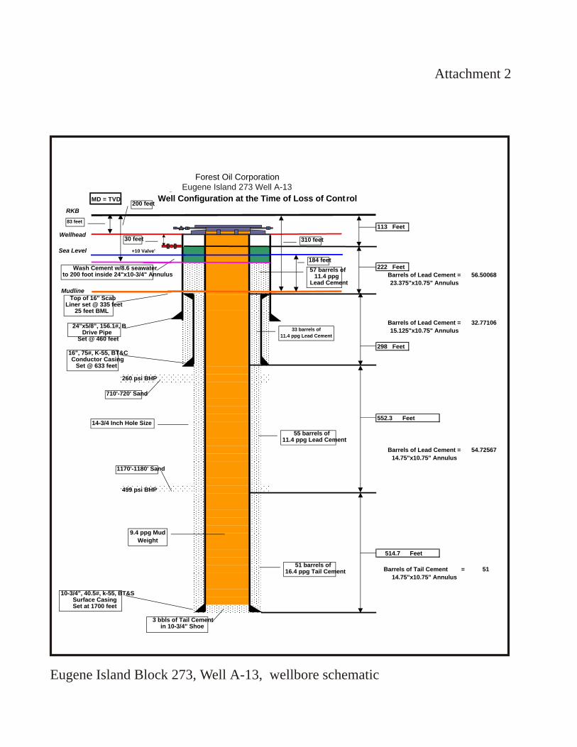
Forest Oil CorporationEugene Island 273 - OCS-G 0991 - Well A-13
MD = TVD Well Configuration at the Time of Loss of Control
RKB
113 Feet
Wellhead
Sea Level +10 Valve'
222 Feet
Barrels of Lead Cement = 56.50068
23.375"x10.75" Annulus
Mudline
Barrels of Lead Cement = 32.77106
15.125"x10.75" Annulus
298 Feet
260 psi BHP
552.3 Feet
55 bbls
Barrels of Lead Cement = 54.72567
14.75"x10.75" Annulus
499 psi BHP
514.7 Feet
Barrels of Tail Cement = 51
14.75"x10.75" Annulus
83 feet
30 feet
Top of 16" Scab Liner set @ 335 feet
25 feet BML
24"x5/8", 156.1#, B Drive Pipe
Set @ 460 feet
16", 75#, K-55, BT&C Conductor Casing
Set @ 633 feet
310 feet
184 feet
Wash Cement w/8.6 seawaterto 200 foot inside 24"x10-3/4" Annulus
55 barrels of11.4 ppg Lead Cement
10-3/4", 40.5#, k-55, BT&SSurface Casing Set at 1700 feet
710'-720' Sand
1170'-1180' Sand
51 barrels of16.4 ppg Tail Cement
3 bbls of Tail Cement in 10-3/4" Shoe
9.4 ppg Mud
Weight
14-3/4 Inch Hole Size
33 barrels of
11.4 ppg Lead Cement
57 barrels of11.4 ppg
Lead Cement
200 feet
Attachment 2
Eugene Island Block 273, Well A-13, wellbore schematic
Eugene Island 273 Well A-13

Attachment 3
Eugene Island 284 Slip on Wellhead and Plus 10 Valve Schematic
1/2 inch gap between
24 inch base plate &
10-3/4 inch surface casing
10-3/4 inch Slip On Wellhead (SOW)
by 11 inch 5000 psi casing head
10-3/4 inch Surface Casing
24 inch Drive Pipe
Control Line to
Driller's Console
Remote Controlled Full
Opening 6" Air
Operated Ball Valve
10' to water line
Water Line
24 inch Drive Pipe
by 10-3/4 inch Surface
Casing Annulus
Slip-on wellhead schematic and +10 valve schematic

Attachm
ent 4
Ensco 51
Eugene IslandBlock 273-A
Gas Flow from+10 valve
Flow at +10 valve and fire monitors on location

Attachm
ent 5
Flow at+10 valve
Ensco 51jack-up legs
Eugene IslandBlock 273-A
P/F
Flow at +10 valve

Attachm
ent 6Platform/rig on fire
Fire at+10 valve
Eugene IslandBlock 273
P/FA
Ensco 51

Attachm
ent 7
Ensco 51collapsed
sub-structure &derrick
Ensco 51
Flow at +10 valve
Eugene IslandBlock 273
P/FA
Intermediateflow at A-13
wellhead
Damage to platform and rig resulting from fire

Attachm
ent 8
BOP Stack
Diverter
Cleared main deckEugene Island
273-A P/FDiverter
line
Installation of diverter system and BOP stack