integrated land use–transport model system with dynamic
TRANSCRIPT

19
Transportation Research Record: Journal of the Transportation Research Board, No. 2303, Transportation Research Board of the National Academies, Washington, D.C., 2012, pp. 19–27.DOI: 10.3141/2303-03
R. M. Pendyala, K. C. Konduri, and D. You, School of Sustainable Engineering and the Built Environment, Room ECG252, Arizona State University, Tempe, AZ 85287-5306. Y.-C. Chiu, M. Hickman, and H. Noh, Department of Civil Engi-neering and Engineering Mechanics, University of Arizona, 1209 East Second Street, Room 206A, Tucson, AZ 85721. P. Waddell and L. Wang, College of Environmental Design, University of California at Berkeley, 228 Wurster Hall, Room 1850, Berkeley, CA 94720-1820. B. Gardner, Office of Planning, FHWA, U.S. Department of Transportation, 1200 New Jersey Avenue, SE, HEPP-30, Washington, DC 20590. Corresponding author: K. C. Konduri, [email protected].
Advances in microsimulation approaches to modeling of urban environments have happened rather independently in three streams of research; namely, land use, travel demand, and network supply. For land use modeling, microsimulation approaches are applied to model the urban form in a region, including the land use choices of individuals, businesses, governments, and developers. House-holds within a region make choices about their residential location, whereas individuals within a household make choices about their fixed activity locations, including workplace location, school loca-tion, and college location (while accounting for intrahousehold inter-actions and constraints). Businesses make choices about locating their offices and other related facilities. Developers make decisions about development (on empty parcels of land) or redevelopment (on parcels of land with existing facilities). These land use choices, along with the sociodemographic and economic evolutionary processes, government regulations, and zoning policies, make up the urban form of a region (3–5).
In the travel demand arena, the field has experienced an increasing use of activity-based microsimulation approaches to travel demand modeling and forecasting. Activity-based approaches explicitly rec-ognize the fact that individuals travel to fulfill their need to engage in activities. The primary output from an activity-based travel demand model is the activity–travel patterns of individuals within a house-hold along a continuous time axis (6). The model system comprises various submodels that closely interact with each other to generate household activity agendas, individual activity schedules, activity linkages, trip chaining, destination, and mode choices, subject to the different household interactions (including interactions among household members) and temporal, spatial, and monetary constraints (7). A rich body of literature describes various implementations of activity-based model systems (8). These model systems differ from each other by the underlying behavioral paradigms that they use to represent activity–travel decision-making behavior and by the various degrees to which they represent choice processes (9).
Network assignment is typically the last step in any transport model. Conventional assignment methods do not recognize that transporta-tion networks evolve continuously through the day, and the under-lying assumption of static network conditions in many assignment models in practice leads to results that are unlikely to be representa-tive of actual network conditions. With microsimulation models of travel demand now capable of generating demand at a fine temporal resolution (e.g., 1 min), interest in the deployment of dynamic traf-fic assignment models that explicitly account for network dynamics along a continuous time axis and that thus allow the accurate repre-sentation of people’s path choices and resulting network conditions is increasing (10).
Integrated Land Use–Transport Model System with Dynamic Time-Dependent Activity–Travel Microsimulation
Ram M. Pendyala, Karthik C. Konduri, Yi-Chang Chiu, Mark Hickman, Hyunsoo Noh, Paul Waddell, Liming Wang, Daehyun You, and Brian Gardner
The development of integrated land use–transport model systems has long been of interest because of the complex interrelationships between land use, transport demand, and network supply. This paper describes the design and prototype implementation of an integrated model system that involves the microsimulation of location choices in the land use domain, activity–travel choices in the travel demand domain, and indi-vidual vehicles on networks in the network supply modeling domain. Although many previous applications of integrated transport demand–supply models have relied on a sequential coupling of the models, the system presented in this paper involves a dynamic integration of the activity–travel demand model and the dynamic traffic assignment and simulation model with appropriate feedback to the land use model sys-tem. The system has been fully implemented, and initial results of model system runs in a case study test application suggest that the proposed model design provides a robust behavioral framework for simulation of human activity–travel behavior in space, time, and networks. The paper provides a detailed description of the design, together with results from initial test runs.
Microsimulation approaches to land use and transport modeling allow realistic representations of the decision-making behavior of indi-viduals while recognizing the interactions, constraints, and underly-ing decision-making mechanisms at play (1). The implementation of microsimulation approaches has been facilitated by advances along three fronts, namely, the availability of rich data on individual deci-sion-making behavior in the form of activity–travel surveys and dia-ries, advances in econometric and statistical modeling methods that allow the modeling of complex behaviors of individual agents without making simplifying assumptions, and advances in computational tech-nologies in both the software and hardware domains that allow the efficient estimation of complex models and the simulation of millions of agents within reasonable computational time (2).
20 Transportation Research Record 2303
Dynamic traffic assignment models provide the same outputs as static assignment models, but with an added time dimension; that is, they generate transport accessibility measures of the network that vary with time. This characteristic makes dynamic traffic assign-ment models ideally suited to simulate the impacts of dynamic pric-ing strategies, emerging real-time information technologies, and intelligent transportation system deployments.
Although research in these three fields has proceeded somewhat in parallel, it is widely recognized that important interrelationships and dependencies exist among these modeling domains and that a means to account for linkages across the model systems in an inte-grated framework is needed to accurately model urban environments (11). Land use choices are affected by network travel accessibility measures. In turn, land use choices affect travel demand; one of the major factors affecting the activity–travel choices of individuals are their location choices, including home location, work location, and school location, among others. Travel demand is affected by network accessibility measures; that is, the temporal and spatial coordinates of the destination opportunity space are limited by conditions on the network (e.g., speed and delays). Finally, network conditions are affected by the travel demand that is generated: where people travel and the routes that they take affect conditions on the network.
Considerable progress in the conceptualization and operation-alization of integrated modeling approaches that seek to model the different components of urban environments, namely, land use, activity–travel demand, and network supply, in a single unifying framework has been made. Although some frameworks have empha-sized linkages between land use and travel demand (4, 5, 12), other frameworks have focused on the travel demand and network supply interrelationships (13–17). However, in most of these integration approaches, linkages across model systems are established rather loosely through sequential feedback processes and data exchange mechanisms. Limited attempts to integrate the three model systems in a single unifying framework have been made largely because of the complexity associated with individual model systems, the ana-lytical challenges associated with the linking of these systems that operate at different temporal and spatial resolutions, and the com-putational challenges associated with microsimulation of all three components of an urban environment.
In this research effort, an integrated modeling system dubbed SimTRAVEL (Simulator of Transport, Routes, Activities, Vehi-cles, Emissions, and Land) is presented with a view toward tying component model systems more tightly in a behaviorally con-sistent fashion. A prototype has been developed and tested on a three-city subarea in the southeast region of the Phoenix, Arizona, metropolitan area.
The next section provides an overview of the integrated model design. The third section describes the operational implementation of the integrated model system, along with a description of the indi-vidual model systems and the software that supports the integrated model system. The fourth section presents a brief overview of the study area; this overview is followed by a presentation of results in the fifth section and concluding thoughts in the final section.
Design of an integrateD MoDel systeM
Bootstrapping Procedure and synthetic Population generator
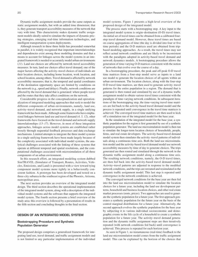
The proposed design comprises a generalized framework for inte-grating land use, travel demand, and traffic assignment models and is not limited to any particular implementation of the individual
model systems. Figure 1 presents a high-level overview of the proposed design of the integrated model.
The process starts with a bootstrapping step. A key input to the integrated model system is origin–destination (O-D) travel times. An initial set of travel times can be obtained from a calibrated four-step travel demand model. However, these travel times are based on coarse aggregations of time (the day is divided into four or five time periods) and the O-D matrices used are obtained from trip-based modeling approaches. As a result, the travel times may not reflect actual network conditions and are likely to be inconsistent with the paradigms adopted in activity-based travel demand and network dynamics models. A bootstrapping procedure allows the generation of time-varying O-D matrices consistent with the notion of networks that evolve over the course of a day.
In a bootstrapping procedure, the peak and off-peak O-D travel time matrices from a four-step model serve as inputs to a land use model to generate the location choices of all agents within an urban environment. The location choices, along with the four-step O-D travel time matrices, are then used to generate activity–travel patterns for the entire population in a region. The demand that is generated is then routed and simulated by use of a dynamic traffic assignment model to obtain various travel times consistent with the paradigm of time-varying network conditions. In subsequent itera-tions of the bootstrapping step, the time-varying travel time matri-ces are fed back to the activity-based travel demand model and the process is repeated until convergence in the travel time matrices is achieved. The converged travel time matrices are then used to kick off a simulation run of the integrated model for the base year.
In the simulation of the integrated model for the base year, a syn-thetic population for the region is first generated by use of a synthetic population generator. The land use microsimulation model is then run to simulate the longer-term location choices of households, people, firms, and real estate developers. The activity-based travel demand model system then simulates the activity–travel patterns of individ-uals along a continuous time axis. Both the land use microsimula-tion model and the activity-based travel demand model use network accessibility measures by time of day to generate choices. The trips generated are then routed and simulated through the network in the dynamic traffic assignment model along a continuous time axis. The resulting network conditions, namely, the O-D travel times, are then fed back into the activity-based travel demand model. Activity–travel patterns are adjusted in response to the modified network conditions, and the trips are rerouted and resimulated in the dynamic traffic assignment model. This last step is repeated until convergence in the network conditions is achieved.
The converged network conditions for the base year are then fed into the land use microsimulation model to simulate the location choices for a future year, including the land use development pat-terns, household and business location choices, and other real estate market processes (rents, prices). Two approaches are used to gener-ate the synthetic population for a future year. The first approach gen-erates a synthetic population for the future year on the basis of the control marginal distributions for a future year. Alternatively, the second approach evolves the synthetic population for the base year by subjecting it to various individual socioeconomic and demo-graphic events in the life cycle of a household to create a synthetic population for a future year. The activity–travel demand genera-tion and the dynamic traffic assignment steps are then iteratively repeated (with network conditions fed back) until convergence is achieved. This process is repeated for each horizon year.
As seen in Figure 1, no instantaneous (real-time) feedback to the land use microsimulation model comes from the traffic assignment model. This can be explained by the horizon of the choices that
Pendyala, Konduri, Chiu, Hickman, Noh, Waddell, Wang, You, and Gardner 21
each of these model systems aims to simulate. The land use model primarily deals with longer-term choices (location, employment, residential land use), whereas the activity–travel demand model and the dynamic traffic assignment model deal with shorter-term activity–travel choices that are closely linked. The accessibility indicators that people experience in one year are assumed to affect the location choice decisions for a subsequent year, and the location choices in turn then affect the integrated activity–travel demand and supply model system for that year.
The proposed approach is quite generic and can be operational-ized by the use of any land use, travel demand, and traffic assign-ment models, so long as consistency in the treatment of behaviors and consistency in the representation of behavioral units, space, and time are maintained across model systems. Although it may appear that the integrated modeling framework presented in this section resembles sequential integrated modeling approaches that have been proposed in the literature and implemented in practice, an important distinction in the processes used to establish the link-ages and interdependencies between the travel demand and the traf-fic assignment components of the integrated model system can be drawn. This linkage is described in the next section.
Dynamic activity–travel simulation
An approach often proposed to integrate the demand model and the network supply model is to run the models sequentially with feedback of the network conditions to the demand model until convergence is achieved. In this naive sequential approach to integration, the indi-
vidual model systems are run independently and loosely coupled together with input–output data flows (15). In sequential imple-mentations of integrated model systems, the activity-based travel demand model is run first to simulate the activity–travel patterns for the entire population for a full 24-h period. The activity–travel patterns are then converted to trip lists (17) or trip tables (13) so that they may be fed into a dynamic traffic assignment model. In this approach, information and the possibility to introduce spatial and temporal inconsistencies into the activity–travel schedules of individuals are potentially lost. If the approach in which trip tables are created from individual activity–travel schedules is considered, trips can no longer be traced back to the individual who engages in the activity–trip, and information is thus lost.
Even in approaches in which trip lists are passed with individual information attached to each trip, the sequential approach fails to capture the emergent nature of activity–travel scheduling behavior in response to actual arrival time (network conditions). For example, if a person arrives at his or her destination earlier than expected, the sequential approach would not allow the person to alter or modify his or her activity agenda causing a wait until the next activity–travel decision point. However, it is likely that the person may start pursuing the activity early and also potentially finish the activity early, leav-ing a larger time–space prism window to engage in other activities or reschedule subsequent activities. Thus, sensitivity and response to actual arrival information are important in the simulation of activity–travel engagement and scheduling decisions for fixed and, more important, nonfixed (discretionary and maintenance) activities.
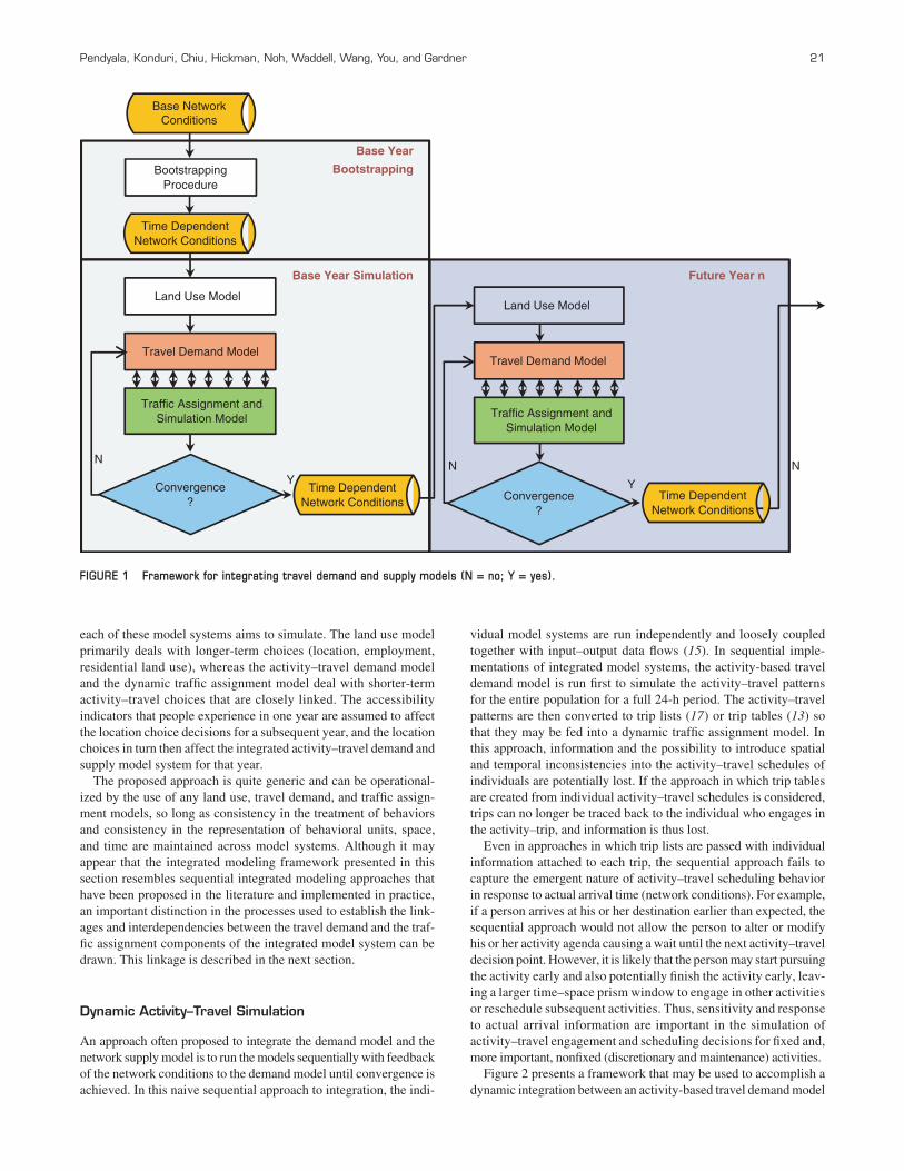
Figure 2 presents a framework that may be used to accomplish a dynamic integration between an activity-based travel demand model
Future Year n
Base Year
Bootstrapping
Base Year Simulation
Time Dependent Network Conditions
Travel Demand Model
Traffic Assignment and Simulation Model
Convergence ?
Land Use Model
Travel Demand Model
Traffic Assignment and Simulation Model
Convergence ?
Land Use Model
Y
N
Y
N N
Base Network Conditions
Bootstrapping Procedure
Time Dependent Network Conditions Time Dependent
Network Conditions
FIGURE 1 Framework for integrating travel demand and supply models (N = no; Y = yes).
t = 0 min t = 1 t = 2 t = 9
Activity-Travel Demand Model
Dynamic Traffic Assignment
Vehicle is loaded on the network and trip is simulated
Person(s) pursues activity
1440 minutes
Trip Record 1 Origin O1,
Destination D1,
Mode M1,
Vehicle
Trip Record 2 Origin D1,
Destination D2,
Mode M2,
Vehicle Update O-D Travel Times
6 second interval
Update Time- Dependent
Shortest Path Set
New Link Travel Times
FIGURE 2 Framework for integrating travel demand and supply models.

Pendyala, Konduri, Chiu, Hickman, Noh, Waddell, Wang, You, and Gardner 23
and a dynamic traffic assignment model. This framework overcomes the limitations of sequential integration approaches mentioned above by maintaining consistency in the representation of behavioral units, spatial relationships, and temporal scales. The model design can be traced to the attempts to integrate an activity-based travel demand model system called PCATS (Prism-Constrained Activity–Travel Simulator) with a microscale–mesoscale dynamic traffic assignment model system called DEBNetS (Dynamic Event-Based Network Simulator).
Early efforts to integrate the two model systems adopted the sequen-tial approach, with simple input–output flows enabling the integration (15). A tighter integration paradigm was proposed to overcome the various challenges associated with sequential approaches (18). In that paradigm, the travel demand model and the dynamic traffic assign-ment model constantly communicate with each other along a continu-ous time axis. The resulting activity–travel engagement decisions are truly emergent; and the decision to engage in activities and the vari-ous activity–travel dimensions, including activity type, activity dura-tion, destination, departure time, route, and arrival time, are generated and simulated as they happen.
The design presented here builds on the event-based approach proposed by Kitamura et al. (18), with major enhancements in the heuristics used to reschedule activities in response to arrival time information.
After network conditions by time of day are obtained from a bootstrapping procedure, the framework shown in Figure 2 can be used to simulate activity–travel decisions. The typical time resolu-tion of an activity–travel demand model is 1 min. Thus, the day can be broken down into 1,440 intervals in which activity–travel choices need to be simulated for the entire population. Within each minute, the demand model simulates the activity–travel engage-ment decisions of all individuals. For those individuals who make a decision to pursue an activity away from the current location, trip information, including origin, destination, mode, and vehicle, is extracted and passed to the dynamic traffic assignment model to load the trips on the network. The dynamic traffic assignment model routes the trips and simulates them on the network. The routes are generated in the dynamic traffic assignment model on the basis of Wardrop’s principle of user equilibrium (i.e., the trips are assigned to paths between an O-D pair, such that the travel times across all paths between the O-D pair are equal).
A dynamic traffic assignment model is usually capable of simulat-ing vehicular movements and positions at a finer temporal resolution (less than 1 min). To avoid lumpy loading of the vehicles onto the network within a 1-min simulation, the dynamic traffic assignment model uniformly distributes the trips across the 1-min simulation interval. For example, if the dynamic traffic assignment operates at a resolution of 6 s, then the trips are distributed uniformly across the 1-min simulation interval and loaded on the network every 6 s.
After the trips are loaded, the dynamic traffic assignment model simulates the movement of vehicles on the network. The vehicle’s position is updated at the end of every 6 s. The dynamic traffic assign-ment stores service conditions (typically, link travel times, volumes, and delays, among others) at the network level. It is theoretically possible for the traffic assignment model system to store measures of the network level of service at a resolution of 6 s and then feed those back for the subsequent iteration. However, it becomes com-putationally burdensome and it may be behaviorally unwarranted to store network conditions at such a fine temporal resolution. In addition, it is difficult to imagine that individuals consider network conditions at a resolution of 6 s when they make activity–travel
decisions. It may be reasonable to store network conditions at the same resolution as the activity–travel demand model (at a 1-min resolution or higher).
The vehicular movements are executed on the network until the trips arrive at their intended destinations. Once the trips have arrived at their destinations, the dynamic traffic assignment model passes back the arrival information to the demand model so that the latter can simulate subsequent activity–travel engagement decisions. After the arrival information is received, the demand model makes appro-priate adjustments to the activity–travel schedule of an individual in response to his or her arrival time, and the individual pursues the activity at the destination before reaching the next activity–travel engagement decision point. Because the dynamic traffic assignment model operates at a resolution of 6 s, all of the trips that have arrived at their destination within any 1-min interval are collected and the arrival information is sent to the demand model.
At the end of the simulation for a day, the network conditions are processed by time of day to generate O-D travel time matrices by time of day for use in the travel demand model, and time-dependent shortest paths between O-D pairs are generated for use in the dynamic traffic assignment model in the subsequent iteration. The updated net-work conditions are fed into both the demand model and traffic assignment model for the next iteration. The process is repeated until convergence in both travel demand and network conditions is achieved. It must be noted that the shortest paths are based on network conditions from a previous iteration because link condi-tions cannot be forecast into the future without an actual simulation of trips (network conditions in a future period are needed to calcu-late time-dependent shortest paths). Similarly, the network condi-tions from a previous iteration are used to simulate activity–travel engagement decisions in any given iteration. However, the arrival time information, based on which activity–travel schedule adjust-ments and activity engagement decisions are made, is generated in real time as trips are simulated through the day.
The proposed approach to dynamic linkage between the activity–travel demand system and the dynamic traffic assignment model has some features that are behaviorally appealing. First, arrival times are determined by real-time conditions on the network along a continuous time axis and are not based on a predetermined state of the network from a previous iteration. This process maintains continuity and con-sistency in the temporal and spatial representation of activity–travel engagement decisions, which is often a point of contention in the more naive sequential approach to integration.
Second, the feedback of network conditions from one iteration to the next mimics a day-to-day learning process in which individuals make activity–travel engagement decisions and adjust schedules in response to their travel experience from the previous iteration. This learning behavior is captured by the outer feedback loop shown in Figure 2.
Finally, the framework lends itself to the evaluation of policies and scenarios that involve network dynamics and understanding of the impact of such dynamics on activity–travel engagement behav-ior. For example, the impact of traveler information systems can be evaluated or the dissipation of network shocks (incidents) and their effects on individual decisions on the use of time and engagement in activities can be modeled.
Scenarios of network disruption can be set up and evaluated in the proposed integrated model design because of the dynamic minute-by-minute handshaking that allows one to capture the scheduling and rescheduling decisions and alternative routing decisions that people would pursue in response to network dynamics. If an individual

24 Transportation Research Record 2303
arrived late at a certain destination (say, because of congestion on the network), then the duration of that activity, as well as the pat-tern of engagement in subsequent activities, may be affected. Certain discretionary activities that would otherwise have been pursued (had the individual not been delayed) may instead be eliminated to meet various daily schedule constraints. The evaluation of such schedul-ing dynamics in a sequential design would inevitably entail the use of ad hoc procedures to modify activity–travel patterns.
The proposed design offers a behaviorally intuitive framework for modeling the dynamics associated with the demand for and supply of transportation systems.
oPerational iMPleMentation of integrateD MoDel Design
The framework presented in the previous section was used to build an integrated model system dubbed SimTRAVEL. To start the micro-simulation of the urban continuum, a synthetic population for the entire region is necessary. In this context, it is important to ensure that the characteristics of the synthetic population match not only known distributions of household variables of interest but also known dis-tributions of person variables of interest. This will ensure that the profile of the synthetic population closely matches the household and individual socioeconomic and demographic profiles of the region, which in turn affect land use, activity–travel engagement, and route choice decisions.
PopGen (version 1.1) is the synthetic population generator used in SimTRAVEL (19). The land use microsimulation model that was used in the development of the SimTRAVEL prototype is Urban-Sim (5). UrbanSim is an open-source land use microsimulation model that comprises a series of models that simulate the location choices of households, people, businesses, and real estate agents while explicitly considering the zoning policies and restrictions that built environments experience.
The travel demand microsimulation model system incorporated in SimTRAVEL is OpenAMOS. OpenAMOS is an open-source activity-based travel demand model system that generates the daily activity–travel patterns of individuals. OpenAMOS builds on a long legacy of activity-based model development (15). Some fundamen-tal behavioral paradigms from the legacy implementation, such as the explicit modeling and recognition of time–space prism verti-ces, have been preserved in OpenAMOS. However, OpenAMOS enhances the earlier model framework to account for child depen-dency and allocation processes, intrahousehold activity–travel engagement interactions, and multimodal travel simulation.
Finally, the dynamic traffic assignment microsimulation model sys-tem that was deployed in the integrated model prototype is MALTA (Multiresolution Assignment and Loading of Traffic Activities) (20). The traffic assignment process is handled by a new hierarchical time-dependent shortest-path algorithm for the highway modes and a new microsimulation model for the transit modes.
Case stuDy test site
Initial tests of the prototype are being conducted for a three-city subarea in the southeast region of the Phoenix metropolitan region. The subarea covers the city of Chandler, the town of Gilbert, and the town of Queen Creek. About half a million people (505,350)
residing in 167,738 households live in this subarea. Although activ-ity–travel engagement decisions are being generated only for the three-city region in OpenAMOS, the dynamic traffic assignment model (MALTA) uses the entire network of the Phoenix metro-politan region for routing and simulation. Therefore, in an effort to reflect the presence of congestion on the network, the background traffic that is generated by the population outside the study area was also loaded.
Background traffic was incorporated by disaggregation of peak and off-peak O-D matrices obtained from the four-step travel model for the region into trip lists by the use of temporal distributions from the latest National Household Travel Survey. In each time step, the disaggregated trip lists were then added as background traffic to supplement the demand generated by OpenAMOS for the subarea and thus capture real-world network conditions.
results
The provision of comprehensive results of the case study application of SimTRAVEL is impossible within the scope of this paper. Such a comprehensive description of the case study will be the primary focus of a future paper. Interested readers may view more detailed results of various tests and model runs at the SimTRAVEL wiki site (21). Within the context of this paper and relevant to the description of the design, two key measures are examined and discussed here.
One of the major design objectives of the tightly integrated model design was to ensure that time-of-day distributions of activity–travel engagement were accurately replicated by the model system. In the dynamic integrated model design, activity start times get adjusted in response to actual arrival times at destinations simulated by the dynamic network model. In other words, one of the key aspects of the design is the ability to replicate the time-of-day distributions of travel in an accurate way.
If the O-D travel time matrices are accurate representations of the travel times that would actually be experienced in the network, it is unlikely that the dynamic model design and the sequential model design would yield different results. This is because the travel time matrices that dictate time-of-day distributions in the sequential model design would be similar to the actual travel times experienced by travelers in the network simulated by the dynamic integrated model design. However, the question remains whether the dynamic integrated model design, with all of its schedule adjustments in response to network arrival times, would be able to replicate accurately true time-of-day distributions of travel in the region.
Figures 3 and 4 show time-of-day distributions of trip start times for adult workers and adult nonworkers, respectively. The time of day distributions for these two demographic groups com-pare remarkably well with values derived from the latest edition of the National Household Travel Survey. For workers, one can see the typical peaks in the morning and evening, with a smaller peak appearing during the noon period, presumably due to the lunch hour. For nonworkers, the distributions also match extremely well, although it appears that SimTRAVEL yields a slight overprediction of trips between 11:00 a.m. and 5 p.m. and a slight underprediction of trips beyond 8 p.m.
These extremely good matches in time-of-day distributions sug-gest that the dynamic design is able to represent broad temporal patterns of travel demand. It should be noted, however, that the true

Pendyala, Konduri, Chiu, Hickman, Noh, Waddell, Wang, You, and Gardner 25
0
2
4
6
8
10
12
14
4am- 5am
5am- 6am
6am- 7am
7am- 8am
8am- 9am
9am- 10am
10am- 11am
11am- 12pm
12pm- 1pm
1pm- 2pm
2pm- 3pm
3pm- 4pm
4pm- 5pm
5pm- 6pm
6pm- 7pm
7pm- 8pm
8pm- 9pm
After 9pm
Per
cent
of T
rips
OpenAMOS: Workers NHTS: Workers
FIGURE 3 Time-of-day distribution of trip start time for workers (NHTS = National Household Travel Survey).
0
2
4
6
8
10
12
4am- 5am
5am- 6am
6am- 7am
7am- 8am
8am- 9am
9am- 10am
10am- 11am
11am- 12pm
12pm- 1pm
1pm- 2pm
2pm- 3pm
3pm- 4pm
4pm- 5pm
5pm- 6pm
6pm- 7pm
7pm- 8pm
8pm- 9pm
After 9pm
Per
cent
of T
rips
OpenAMOS: Non-Workers NHTS: Non-Workers
FIGURE 4 Time-of-day distribution of trip start time for nonworkers.
merits of the proposed design can be assessed only when the model system is applied to a scenario in which the network is subjected to a perturbation and disaggregate results from the activity–travel simulation process are examined to the fullest extent.
Another key dimension of the integrated model design is investi-gated through the information in Figure 5, which compares the over-all trip rates for maintenance and discretionary activities for worker and nonworker segments provided by the sequential model design and the dynamic integrated model design described in this paper. In virtually all cases, the sequential model design yielded a higher trip
rate than the dynamic integrated model design. In fact, the dynamic integrated model design generated a total of 1.456 million trips for the subarea that constitutes the test area, whereas the sequential model design generated a total of 1.506 million trips.
It appears that the sequential model design may not accurately capture the adjustments in activity engagement that people make because the travel times experienced are different from the travel times expected. When an actual arrival time is later than an expected arrival time, the remaining time in the open time–space prism is less than what would be otherwise available.

26 Transportation Research Record 2303
As a result of this shrinkage of the time–space prism, an individual might forgo an additional activity and, instead, postpone the activity to the next day. This type of activity generation adjustment is not reflected in the sequential model design. As a result, the average trip rates for nonmandatory activities are higher in the sequential model design than in the dynamic integrated model design. Indeed, if the expected travel times closely replicate the actual travel times that would be experienced on the network, these differences would be negligible. However, the dynamic integrated model design ensures that the effects of network congestion that would inevitably affect arrival times are accurately captured in simulations of the activity engagement behavior of individuals.
It is entirely possible to argue that even a sequential model design can replicate patterns without much difficulty, as long as expected travel times (in the skim matrices) accurately reflect true travel times in the network. The issue, however, is not whether a sequential model design accurately replicates network conditions and travel demand under normal conditions. The question is whether a simpler naïve sequential model design can replicate behaviors and network condi-tions when a shock or policy is introduced into the system in the middle of a day (in a simulation). From a pure conceptual standpoint, the dynamic integrated model design presented in this paper would have the ability to simulate adjustments in schedules and behaviors that would follow such an event. It would be virtually possible for a sequential design to mimic such behavioral adjustment processes.
The results demonstrate the feasibility of the integrated modeling approach presented in this paper. An issue that merits further explo-ration is that of computational tractability. Run times are naturally dependent on the hardware configuration. On a standard quad-core personal computer workstation, run times for a simulation of just over 15 million trips are on the order of about 24 h per complete iteration, with a dynamic model design run taking on the order of about 3 to 4 h longer than a sequential model design run. It is envi-sioned that these run times will come down as computing power improves and parallel computing capabilities are harnessed to the extent possible.
ConClusions
This paper presents the design of an integrated land use–transport model system that incorporates a tight dynamic coupling between an activity-based microsimulation model system of travel demand and a dynamic network assignment and simulation model of net-work supply. Although considerable developments in the integrated transport model formulation arena have taken place over the past decade, the implementation of a tightly integrated model system has remained a major challenge to the profession.
Many emerging policy questions call for an integrated transport demand–supply model system capable of responding to changing network conditions through the course of a day. In the event of unex-pected congestion (say, because of an incident), travelers may arrive at their destination location later than expected. This late arrival would have cascading effects on the subsequent activities, destina-tions, and durations. Through a tightly integrated model design, it is possible to reflect the effects of such network dynamics on emer-gent activity–travel behavior. Similarly, in the event that intelligent transportation systems or dynamic pricing strategies are deployed, travelers may be able to arrive at their destinations more quickly than originally anticipated.
The additional time that becomes available to the traveler may lead to induced travel or activity engagement. This additional time comprises shorter-term induced or suppressed demand in response to network conditions. Additionally, an integrated model system that can account for longer-term land use changes on the transport sys-tem would be of considerable value to the profession, which is con-stantly grappling with the complex interrelationship between land use development and network accessibility. The integrated model system presented in this paper is able to capture both the shorter-term and longer-term impacts noted above.
The integrated model design described in this paper is a continuous-time model system capable of simulating activities and travel patterns in response to actual network conditions that travelers experience as they execute their daily activities and travel in time and space. The
0
0.5
1
1.5
2
2.5
Workers Maintenance Workers Discretionary Non-workers Maintenance Non-workers Discretionary
Ave
rage
Trip
Rat
es
Dynamic Sequential
FIGURE 5 Difference in average trip rates between sequential and dynamic integrated model runs.

Pendyala, Konduri, Chiu, Hickman, Noh, Waddell, Wang, You, and Gardner 27
model operates at the level of resolution of 1 min. In each minute of the day, the activity–travel demand model provides the network supply model the list of trips that need to be routed to their desti-nation, whereas the network supply model returns the list of trips that have arrived at their destination locations. This results in a dynamic interaction between the demand and supply models on a minute-by-minute basis.
The model system includes algorithms to facilitate convergence, and the final accessibility measures from any single simulation year inform the land use choices of a subsequent simulation year. Thus, the model design accommodates the time lags that are inevitably involved in land use changes in response to changes in network conditions. The integrated land use–transport model system explicitly recognizes that different choice processes operate on different temporal and spatial scales.
The model system has been implemented as an open-source soft-ware package, and a prototype has been tested in a three-city juris-diction of the southeast region of the greater Phoenix metropolitan area. The model system is found to perform well when it replicates observed activity–travel patterns reported in national travel sur-vey data. The results are promising, and the model design appears to provide a conceptually appealing framework that ties together microsimulation model systems of activity–travel demand, network supply, and land use.
The richness of the specification of the model system, however, dictates the extent to which the model system can be used to analyze the effects of alternative policies or socioeconomic shifts. In other words, the model design presented in this paper is not a substitute for the adoption of rich specifications that include numerous explanatory variables capturing the effects of socioeconomics, demographics, built environment attributes, and policy interventions.
The aim of future work in this area should be to address the imple-mentation challenges and issues that inevitably arise when large-scale integrated microsimulation model systems are transitioned into practice. Issues of data availability, disaggregate and aggregate vali-dation, convergence, sensitivity to alternative policies and built-environment changes, and computational tractability need to be tackled before model systems of the nature described in this paper can be implemented in the real world.
aCknowleDgMents
The financial support provided by FHWA, U.S. Department of Trans-portation, under the Exploratory Advanced Research Program is gratefully acknowledged. The authors appreciate the helpful com-ments provided by anonymous reviewers on an earlier version of the paper.
referenCes
1. Kitamura, R., C. Chen, R. M. Pendyala, and R. Narayanan. Micro-Simulation of Daily Activity–Travel Patterns for Travel Demand Forecasting. Transportation, Vol. 27, No. 1, 2000, pp. 25–51.
2. Goulias, K. G., and R. Kitamura. Travel Demand Forecasting with Dynamic Microsimulation. In Transportation Research Record 1357, TRB, National Research Council, Washington, D.C., 1992, pp. 8–17.
3. Martinez, F. J. The Bid-Choice Land Use Model: An Integrated Eco-nomic Framework. Environment and Planning A, Vol. 24, No. 6, 1992, pp. 871–885.
4. Salvini, P., and E. J. Miller. ILUTE: An Operational Prototype of a Comprehensive Microsimulation Model of Urban Systems. Networks and Spatial Economics, Vol. 5, 2005, pp. 217–234.
5. Kitamura, R., and S. Fujii. Two Computational Process Models of Activity–Travel Behavior. Theoretical Foundations of Travel Choice Modeling (T. Gärling, T. Laitila, and K. Westin, eds.), Pergamon Press, Oxford, United Kingdom, 1998, pp. 251–279.
6. Arentze, T. A., and H. J. P. Timmermans. A Learning-Based Transpor-tation Oriented Simulation System. Transportation Research Part B, Vol. 38, No. 7, 2004, pp. 613–633.
7. Henson, K. M., and K. G. Goulias. Preliminary Assessment of Activity and Modeling for Homeland Security Applications. In Transportation Research Record: Journal of the Transportation Research Board, No. 1942, Transportation Research Board of the National Academies, Washington, D.C., 2006, pp. 23–30.
8. Pendyala, R. M., Y.-C. Chiu, and P. Waddell. Modeling the Urban Con-tinuum in an Integrated Framework: Location Choice, Activity–Travel Behavior, and Dynamic Traffic Patterns. Interim report. Exploratory Advanced Research Program, FHWA, U.S. Department of Transporta-tion, 2008.
9. Peeta, S., and A. Ziliaskopoulos. Foundations of Dynamic Traffic Assignment: The Past, the Present and the Future. Networks and Spatial Economics, Vol. 1, No. 3–4, 2001, pp. 233–266.
10. Miller, E. J. Integrated Urban Models: Theoretical Prospects. Presented at 11th International Conference on Travel Behaviour Research, Inter-national Association for Travel Behaviour Research, Kyoto University, Japan, Aug. 2006.
11. Waddell, P. A., X. Liu, and L. Wang. UrbanSim: An Evolving Planning Support System for Evolving Communities. Planning Support Systems for Cities and Regions (R. K. Brail, ed.), Lincoln Institute of Land Policy, Cambridge, Mass., 2008, pp. 103–138.
12. Wagner, P., and M. Wegener. Urban Land Use, Transport, and Environ-ment Models. NSL Network City and Landscape: DISP-Online, 2007, pp. 45–56.
13. Lin, D.-Y., N. Eluru, S. T. Waller, and C. R. Bhat. Integration of Activity-Based Modeling and Dynamic Traffic Assignment. In Transportation Research Record: Journal of the Transportation Research Board, No. 2076, Transportation Research Board of the National Academies, Washington, D.C., 2008, pp. 52–61.
14. Cetin, N., K. Nagel, B. Raney, and A. Vollmy. Large-Scale Multi-Agent Transportation Simulations. Computer Physics Communications, Vol. 147, No. 1–2, 2002, pp. 559–564.
15. Kitamura, R., A. Kikuchi, and R. M. Pendyala. Integrated, Dynamic Activity-Network Simulator: Current State and Future Directions of PCATS-DEBNetS. Presented at Second TRB Conference on Innova-tions in Travel Modeling, Portland, Ore., June 22–24, 2008.
16. Rossi, T. Integration of an Activity Based Model, Traffic and Tran-sit Simulation Model, and MOVES. Presented at 13th TRB National Transportation Planning Applications Conference, Reno, Nev., 2011.
17. Castiglione, J., S. Lawe, J. Bowman, M. Bradley, and D. Roden. Sen-sitivity Testing of an Integrated Regional Travel Demand and Traffic Microsimulation Model. Presented at 13th TRB National Transporta-tion Planning Applications Conference, Reno, Nev., 2011.
18. Kitamura, R., A. Kikuchi, S. Fujii, and T. Yamamoto. An Overview of PCATS/DEBNetS Microsimulation System: Its Development, Exten-sion, and Application to Demand Forecasting. Simulation Approaches in Transportation Analysis: Recent Advances and Challenges (R. Kita-mura and M. Kuwahara, eds.), Springer, New York, 2005, pp. 371–399.
19. Ye, X., K. C. Konduri, R. M. Pendyala, B. Sana, and P. Waddell. Meth-odology to Match Distributions of Both Household and Person Attributes in the Generation of Synthetic Populations. Presented at 88th Annual Meeting of the Transportation Research Board, Washington, D.C., 2009.
20. Chiu, Y.-C., and J. A. Villalobos. The Anisotropic Mesoscopic Simu-lation Model on the Interrupted Highway Facilities. Presented at the Symposium on the Fundamental Diagram: 75 Years (Greenshields 75 Symposium), Woods Hole, Mass., 2008.
21. SimTRAVEL Project Wiki Site. Arizona State University, Tempe, 2008. http://simtravel.wikispaces.asu.edu. Accessed Nov. 15, 2011.
The Transportation Demand Forecasting Committee peer-reviewed this paper.