int. j. hum. capital urban manage., 3(4): 265-278, autumn …
TRANSCRIPT

Int. J. Hum. Capital Urban Manage., 3(4): 265-278, Autumn 2018
*Corresponding Author:Email: [email protected].: +92 321 9891780 Fax: +92 51 9292147
International Journal of Human Capital in Urban Management (IJHCUM)
Homepage: http://www.ijhcum.net/
ORIGINAL RESEARCH PAPER
Site selection of water storage based on multi-criteria decision analysis
S.H. Raza1, M. Shafique2, M. Zia-ur-Rehman1, A. Sikandar3, N. Ahmad1,*, K. Shah4
1Department of Forestry and Range Management, Arid Agriculture University, Rawalpindi, Pakistan2Center of Excellence in Geology, Peshawar, Pakistan3Department of Environmental Sciences, Arid Agriculture University, Rawalpindi, Pakistan4Sub-divisional Wildlife Officer, Mardan Wildlife Division, Khyber Pukhtunkhwa Wildlife Department, Pakistan
Water loss can be minimized and conserve through constructing small storage dams for various irrigation purposes to support local livelihood. Geographic information system provides powerful techniques for many hydrological modeling and suitable dam site selection. The current study explored potential sites for small storage dams to meet agricultural requirements in district Malakand, Khyber Pukhtunkhwa. Multi criteria decision analysis was used for selection of suitable sites for storage dam for agricultural purpose. The methodology was completed in four main steps; acquisition of data, selection of factors and constraints, giving percentage influence to each criterion and performing weighted overlay. Digital elevation model was used for watershed analysis and Landsat 8 image for land use classification. All contributing factors such as slope, soil map, settlements, canals, roads, river, watershed and recreational sites were used in weighted overlay for suitable site selection. Results showed that Masooka rockland soil possessed the highest suitability for dam construction as the high clay proportion of the soil provides cementation. Slope zone of 0-3.16 degree slope was considered best and 3.16-7.90 degrees was highly suitable. Distance (5-10 km or more) form recreational sites and presence of 140-186 Stream links which makes the site more suitable. Regarding land use, the barren land or rangeland was more preferable. Finally, 15 sites were found suitable for small storage dams in the district. The main river lies close to the selected site assuring the perennial flow of water. The study suggests that geographic information system provides efficient tools for decision makers in hydrology and dam site selection.
©2018 IJHCUM. All rights reserved.
ARTICLE INFO
Article History:Received 26 May 2018Revised 12 August 2018Accepted 26 September 2018
Keywords:AgricultureDigital elevation modelGeographical Information System
(GIS)Landsat-8Water conservation
ABSTRAC T
INTRODUCTION
Most of the human life activities depend upon water. Its availability and storage is necessary for irrigation, agriculture, economic development and drinking purpose. Proper management of watershed
areas and catchments not only ensures good water quality, quantity, distribution (Brauman et al., 2007; Lalika et al., 2015; Singh et al., 2014) and but also it assist water storage for irrigation and drinking purposes (Wani et al., 2008). Globally human increasing population, construction activities (Wang et al., 2009) and deforestation (Hlásny et al, 2015)
DOI:10.22034/IJHCUM.2018.04.01

266
S.H. Raza et al.
have disturbed watersheds and manipulated many rivers and streams systems (Mekonnen and Melesse, 2011). Water loss can be minimized and conserve through constructing small storage dams (and utilize it for various irrigation purposes to support local livelihood (Ashraf et al., 2007). Constructing small storage dam is one of the most effective water harvesting technique and it provides multifarious services for sustainable agriculture and water shortage challenges. Dam site selection always crucial because it not only requires proper balance of social, economic, environmental and biological tradeoffs (Hansjürgens et al., 2016), but also need insight survey of all contributing watershed factors which include slope, streams, aspect, soil, geology, vegetation and engineering inputs (Morrison et al., 2016; Elameen, 2017). Inaccurate assessment and selecting a substandard site have many detrimental effects in the long run (Negash et al., 2015). Improper site selection may results in drastic damaging impacts on environments and local people livelihood (Behera et al., 2013). Traditional methods for dam site suitability have many limitations i.e cost, time, labor and resources. Geographical information system (GIS) and remote sensing techniques appeared as powerful multidisciplinary science which provides easy data access, large area coverage and frequent temporal capabilities for many of its applications in hydrology (Lehmann et al., 2014; Dixon et al., 2015), geosciences and agriculture (Xie et al., 2015). GIS provides powerful analysis for many hydrological modeling for proper watershed management (Butt et al., 2015) and it can assist as decision-making tool for many water related issues (Petty et al., 2016; Johnson 2016, Bhattacharya 2016). Previously geographical information system and remote sensing technologies was used for water harvesting (Singh et al., 2017; Al-Abadi et al., 2017), suitable dam site selection (Bódis et al., 2014; Terêncio et al., 2017), multipurpose water reservoirs (Chhuon et al., 2016) and run-off water assessment (Saraswat et al., 2016; Johnson, 2016). Generally dams are constructed on rivers as these river systems are affected by human activities all over the world (Al-Adamat et al., 2012). For the economic sustainability and stability of the dam different topographic parameters like elevation and slope variability of the selected dam site should be properly investigated, analyzed and interpreted. Al-Adamat et al., (2012) specified that geographic information
system will provide a complete representation of the dam site as it has the capability to provide fast, accurate as well as reliable data. In India, Singh, Darshdeep, and Lorita (2008) used criteria like slope, infiltration rate of soil, soil type and land use for the decision making to select a suitable dam site in accordance with integrated mission for sustainable development (IMSD). Pakistan is agriculture dependent country as it is largest sector of country’s economy and majority of the population is depend for the livelihood directly or directly. Agriculture sector contribute about 50% to economy and about 24% to overall country gross income products (GDP) (Jamali et al., 2014). Water availability is one of key requirements for irrigation and water scarcity is a critical issue faced by agriculturists (Briscoe et al., 2006). Therefore, water harvesting and storage is mandatory for agricultural activities especially in mountainous areas. The constructions of multipurpose water reservoirs are very essential not only to enhance agricultural production but also to ensure land sustainability and support livelihood (Kijne, 2001). Selection of proper sites for these dams is of critical importance so as to minimize the adverse impacts and to facilitate maintenance. In Pakistan, many researchers have used geographical information system for site suitability for small dams such as Rasooli and Kang, (2015) assessed potential sites in the river Kabul basin; Jamali et al. (2014) investigated various subsurface dams’ sites in Muzafferabad, Gari Habib Ullah and Balakot and Qureshi, (2010) evaluated multi criteria approach for dam site selection. The current study explored potential sites for small storage dams to meet agricultural requirements in district Malakand, Khyber Pukhtunkhwa. This site suitability was evaluated using geospatial technologies using multi criteria as per available ground information for feasibility of these sites. All contributing factors such as slope, soil map, settlements, canals, roads, river, watershed and recreational sites were studied before selecting a suitable site for the dam. This study has been carried out in Malakand district of Pakistan in 2017.
MATERIALS AND METHODS
Study areaThe district Malakand is located in northern part of
Khyber Puktunkhwa Province. Malakand is separated form swat districts and Bajour agency by mountains

267
Int. J. Hum. Capital Urban Manage., 3(4): 265-278, Autumn 2018
ranges on north-east and west respectively. As depicted in (Fig. 1). The district shared its boundaries with four districts which include Lower Dir, Buner, Mardan and Charssada (Jan, 2012).
The overall climate is cold in winters and pleasant in summers. The district is further divided into two major divisions that are Swat Ranizai (northern) and Sam Ranizai (southern). River Swat is the main irrigation and economic source for many small streams and canals in both divisions. The villages of northern division are directly irrigated by river Swat whereas southern villages are irrigated by Upper Swat canal. Two major hydropower stations are already constructed on Upper Swat canal at Jabban and Dargai. The rural population of district Malakand is directly depends on agriculture for their livelihood (Go KPK, 2017). Most of the area covered by hills which cultivation but people cultivate various types of crops in hills where possible. The overall cultivated land is 45681 out of 52134 hectares protected area. The current study focused the Sam Ranizai division because it is more cultivable and productive from agricultural perspective. Batkhela, Dargai, Thana and Sakhakot are major market points and trade centers of the study area. The total area of district Malakand is 952 square kilometers about 1.28 percent of the whole province. About 42.4 percent of the Malakand total population belongs to Sam Ranizai sub-division and almost all are rural depending on agriculture for their livelihood (Go KPK, 2017). Soil texture of many areas also is a limiting factor for agriculture, mostly range from stone gravelly and rocky to loamy
types. The average rainfall is not enough to support agricultural activities, therefore artificial irrigation is necessary for irrigation purposes.
MaterialsThe study used several datasets including raster
as well as vector for deriving different information for site selection. The datasets, their sources and purpose for which it has been used are summarized in Table 1. Various hydrological features and maps production was done in ArcGIS 10.2 whereas Google Earth was used for digitizing various features such roads and rivers etc.
MethodsThe current study used multi criteria decision
analysis (MCDA) for selection of suitable sites for storage dam for agricultural purpose. The methodology was completed in four main steps. Collection of data, selection of factors and constraints, giving percentage influence to each criterion and performing weighted overlay. We have digitized the land use of the study area into various land uses comprising the forest, barren land, agriculture, water bodies and range land respectively. According to Khitam and Al- Maitah, (2005), following parameters should be considered at the time of dam site selection: drainage density of the selected site should be low; sediment load of the stream should be low so that the dam has more capacity to store water; the selected site should have hard rock; rain rich area; low density of tectonic lines so that internal
Fig. 1: Geographic location of the study area in district Malakand of Pakistan
Fig. 1. Geographic location of the study area in district Malakand of Pakistan

268
Dam site suitability using GIS
water movement is less; for more water collection the selected site must be located in anti-dip valley; evaporation rate should be low; the selected site for dam shouldn’t have any effect on natural aquifers; and the selected site have gravity forces in such a way to transport water where it has been collected. Land cover data for this study area has been taken from the Landsat-8 Imagery that was acquired from USGS Earth Explorer. The Scene-ID was “LC08_L1TP_151036_20170409_20170414_01_T1” with Map Projection was “WGS84-UTM-Zone-42”. The image cloud cover was less than 5 %. MCDA (multi criteria decision analysis) has been used for obtaining suitable site for dam construction. The range land was considered the most suitable for dam site among these land use. Slope was derived from the DEM and then it was reclassified into 10 various classes and then put into the weighted overlay (Stemn et al., 2016). Soil map was prepared because it is very important for each water reservoir selection and classified it into 10 classes. The data about the soil properties have been derived from the Soil Science Department of Agriculture University, Peshawar. Settlements were identified and mapped keeping in mind the condition to select the area which is away from the settlements. We digitized the existing roads and reclassified to use in the final site selection which is near to roads network of the propose dam site. The main river swat was digitized from Google earth which runs the north-west corner of the district Malakand. The site selection was solely dependent on availability of water to recharge the reservoir therefore proximity to river Swat tributary was considered. The data used has been derived from DEM (digital elevation model) and to compute stream links, a Raster layer of stream network and a Raster layer of stream flow direction
are used. The Drainage network is computed which is very important for dam site selection. Flow direction is based on DEM and is carried out as the foundation of flow accumulation. Water flows down the slope always towards the steeper cell. A threshold is provided and the cells with flow accumulation value equal to or higher than the threshold are considered as Streams. Then the streams are segmented according to the stream flow and Stream links are produced which records structure information of a drainage network. When stream links are established then the flow direction is adjusted and drainage order is assigned. Higher drainage value indicates that more tributaries are flowing into the stream. A raster stream link and watershed diagram is being shown. Euclidean distance was calculated for the river, roads and settlements of the study area and finally put it into the weighted overlay on the different weighted on the basis of the requirement of the dam site. The factors and constraints were the central part of MCDA for site suitability. The factors indicates where a site is suitable or not suitable for the particular purpose relative to others features. Based on available data and study area knowledge the research adopted factors like slope, soil type, distance from settlements and market points, proximity to roads and closeness to agricultural fields. Further, Boolean algebra was used for suitability analysis; this is a technique which is used for consideration of areas suitability. The Boolean algebra exclude the area which are unsuitable and give code “0” and consider all those area with code “01” which are suitable (Stemn et al., 2016). Using Boolean algebra, based on factors as mentioned in Table 2; a site was assigned 1 when it was considered suitable and 0 when unsuitable. The factors were classified in 4 four classes, ranked as
Table 1: Description of acquired data and their sources
Data Description Source
DEM (SRTM) Digital elevation model (DEM) from which slope and other hydrological features were generated.
The CGIAR Consortium for Spatial Information (CGIAR‐SCI), 2017.
Slope Proper slope and topography details were necessary for optimal site. Digital elevation model Land use map Provide information about major land use of the study area Landsat‐8 Image
Soil type Different soil type of the study area Soil Science Department, Agriculture University Peshawar
Settlements Dataset provide information about settlements at the potential site Planning and Development Department, Govt of Khyber Pakhtunkhwa
Recreation site Information about major recreational areas Pakistan Forest Institute, Peshawar. River Major rivers and its tributaries Google Earth Roads Different roads and its distance from dam site Google Earth
Table 1. Description of acquired data and their sources

269
Int. J. Hum. Capital Urban Manage., 3(4): 265-278, Autumn 2018
high suitable, suitable, least suitable and unsuitable in descending order (Table 2). Based on these factors suitability was explained by the mentioned four classes. Regards to slope, less than 3.1 degrees slope was considered the most suitable, followed by 3.1- 7.9 degrees and more steep slope more than these values were ranked as unsuitable. Regards to distance from roads, 1 km to 2 km was assigned as suitable and larger distances make the site unsuitable (Stemn et al., 2016). Distance from settlements should also considered, farther the site, the more suitable it was, because storage dam site should as distant as possible because many anthropogenic activities can reduce the capacity and life of the dam. The distance from markets and settlements should be at least between 5 km to 10 km or more. Soil type should contain more clay contents because clay enforce cementation and reduce infiltration to greater extent therefore Masooka rock land soil was considered best and Rough mountainous soil was also considered suitable. The dam site should be near to agricultural fields because the primary objective of dam was to assist irrigation in rural areas. Proximity of 400 to 500 meters was considered suitable.
RESULTS AND DISCUSSION
The dam site was selected when the results were found after the weighted overlay analysis. The below mentioned points and criteria were under study.
The criteria was chosen for best dam site location, in which catchment slope, land cover type, soil type and soil texture and others involved have also been discussed by (Abushandi and Alatawi, 2015).
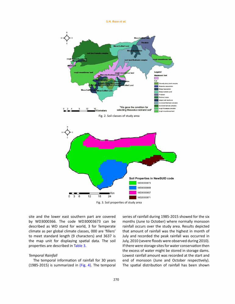
Soil mapAccording to the available data, Masooka rock
Land soil possessed the highest suitability for dam construction as the high clay proportion of the soil provides cementation, inhibiting the infiltration of water into the soil, thus providing the highest water holding capacity (Fig. 2). The site chosen for dam construction was on the basis of soil structure and soil texture (the percentage of sand, silt and clay present) respectively. Clayey soil in comparison to other (sand and silt) possess more capacity to avoid infiltration and highest water holding capacity (clay>silt>sand). Whereas, the soil with high percentage of sand holds the highest rate of infiltration (Brouwer et al., 1990).
Soil PropertiesThe soil properties for Malakand have been
presented in the (Fig. 3). The various codes (soil properties NewSUID code) are shown in (Fig. 3), these codes are explained according to soil properties estimates that were derived from Global Grided Surface (WISE_30sec_V1). These estimates are according to the United Nations Food and Agriculture Organization soil properties database. Most of the area is mainly occupied by WD30003673 while Dam
Table 2: Suitability classes of factors for dam site
Factors Categories Ranking Suitability
Slope
≤ 3.1 4 High Suitable 3.1‐ 7.9 3 Suitable 7.9 – 12.9 2 Low suitable 12.9‐ 19.7 1 Not Suitable
Distance from Roads
≤ 1 000 m 4 High Suitable 1 000 m – 2 000 m 3 Suitable 2 000 m – 3 000 m 2 Low suitable
> 3 000 m 1 Not Suitable
Distance from Settlements and markets
< 10 km 4 High Suitable 5‐10 km 3 Suitable 1‐5 km 2 Low suitable > 1km 1 Not Suitable
Soil Type
Masooka rock land 4 High Suitable Rough mountainous land 3 Suitable
Pirsbak 2 Low suitable Kamala complex 1 Not Suitable
Distance from Agricultural fields
> 500 m 4 High Suitable 400 m – 500 m 3 Suitable 200 m – 400 m 2 Low suitable
> 200 m 1 Not Suitable
Table 2. Suitability classes of factors for dam site
270
S.H. Raza et al.
site and the lower east southern part are covered by WD3000366. The code WD30003673 can be described as WD stand for world, 3 for Temperate climate as per global climate classes, 000 are ‘fillers’ to meet standard length (9 characters) and 3637 is the map unit for displaying spatial data. The soil properties are described in Table 3.
Temporal RainfallThe temporal information of rainfall for 30 years
(1985-2015) is summarized in (Fig. 4). The temporal
series of rainfall during 1985-2015 showed for the six months (June to October) where normally monsoon rainfall occurs over the study area. Results depicted that amount of rainfall was the highest in month of July and recorded the peak rainfall was occurred in July, 2010 (severe floods were observed during 2010). If there were storage sites for water conservation then the excess of water might be stored in storage dams. Lowest rainfall amount was recorded at the start and end of monsoon (June and October respectively). The spatial distribution of rainfall has been shown
Fig. 2: Soil classes of study area
Fig. 3: Soil properties of study area
Fig. 2. Soil classes of study area
Fig. 3. Soil properties of study area

271
Int. J. Hum. Capital Urban Manage., 3(4): 265-278, Autumn 2018
in Fig.5 as per grid provided by Global precipitation data for monsoon period. According to (Fig. 5), the North-eastern part of the study area received highest rainfall due to higher elevation while North-western part received the minimum rainfall. The selected site for water storage receives the water through the River Swat and its adjoining canals flowing from North-eastern parts.
MKD slope
The Malakand district contains various degrees of slopes but the final site selected had 80% area lying under the zone of 0-3.16 degree slope and rest 20% fall in 3.16-7.90 degree slope (Fig. 6). This zone is highly suitable for the construction of dam regarding degree of slope. The slope data used in the weighted overlay analysis was 0-8 Degrees (which is considered as suitable for the dam construction), larger than 8 Degrees was considered not suitable for
dam construction. The slopes above the 8 Degrees were said to be unsuitable to highly unsuitable for the dam construction because it ranges from steeply sloping to very steeply sloping (Adinarayana et al., 1995). Selected dam site consists of small slope and larger catchment area and possess high suitability to store large amount of water with less negative forces acting against the walls of the dam making the site less vulnerable to landslides and slope failure. Slope is one of the most important factor in selection of the site for dam construction as steeper or large degree of slopes pose higher risk of landslides and it induces more pressure on the foundations of the building.
Dam’s road, canal and watershed:The site was considered highly suitable within a
buffer zone of 2km or less as the (Fig. 7) depicted as reported by (Stemn et al., 2016). In (Fig. 7), Canals and watersheds have been shown situated in district
Table 3: Soil Properties of Malakand
Soil property code WD30003673 WD3000366 Depth of top of layer (cm) 60 80 Depth of the bottom layer (cm) 80 100 Coarse fragments (vol% > 2 mm) 22 32 Sand (mass %) 42 35 Silt (mass %) 36 24 Clay (mass %) 22 41 Texture class Moderately well drained Poorly drained Bulk density (kg/dm3) 1.57 1.50 Available water capacity (cm/m) 19 17 Cation exchange capacity (CEC) (cmol/kg) of fine earth fraction 14 15 Total exchangeable bases (cmol/kg) 17 21 CEC clay, corrected for contribution of organic matter (cmol/kg) 61 55 Electrical conductivity (dS/m) 1 0
Table 3. Soil Properties of Malakand
Fig. 4: Temporal rainfall of study area
Fig. 4. Temporal rainfall of study area

272
Dam site suitability using GIS
Fig. 5: Rainfall distribution of study area
Fig. 6: Slope classes
Fig. 5. Rainfall distribution of study area
Fig. 6. Slope classes
Fig. 7: Canal system and main river
Fig. 7. Canal system and main river

273
Int. J. Hum. Capital Urban Manage., 3(4): 265-278, Autumn 2018
Malakand. Watersheds (W2 and W6) are present near the selected site which would provide water to the dam canal system is well spread in the district Malakand and the river flows near the selected dam site which would provide water at the selected dam site that would be conserved and stored for the agricultural purposes. Selected site for dam construction was near the roads and the distance of
dam construction site < 1km from the road Al-Adamat et al. (2012). It provides easy access.
MKD settlement and recreational sitesAccording to results obtained from Boolean
algebra the highest suitable distance of site for dam construction from the settlement lies between 5km-10km or more (Fig. 8). Larger distance suitability is
Fig. 8: Recreational sites and settlements
Fig. 8. Recreational sites and settlements
Fig. 9: Streams links for watershed
Fig. 9. Streams links for watershed

274
S.H. Raza et al.
for two main reasons: 1) to prevent population from any kind of destruction in times of flood. Al-Adamat et al. (2012), has also reported similar results for dam site selection and considered sites suitable for dam construction within 500m or more away from settlement areas.2) due to anthropogenic activities the life span of dam decreases. The selected dam site was 5km-10 km from settlement areas and recreational sites were present at distant places, so any kind of damage could be prevented at time of hazard. The final site was selected after the weighted overlay analysis was performed and the site selected was under highest suitability for dam construction.
MKD dam’s watershedThe selected dam site contains 140-186 Stream
links which makes the site more suitable for the construction of dam (Fig. 9). The watershed (with large number of stream links) that is located near the final site consists of 140-186 stream links which shows that the watershed would provide ample amount of water to the dam site on perennial basis which would be preserved by the dam for agricultural purposes. The results found after weighted overlay analysis showed the highest suitability for the purpose of selection of dam construction site for the selected final site regarding watersheds as well. The stream links are formed by the segmentation of the selected streams according to the drainage of the water,
drainage network is important for dam construction but the stream level which indicates the capacity of water transportation is also very important for dam site selection (O’Callaghan and Mark 1984).
Land use of MalakandAccording to the data gathered the land cover
in Malakand district includes water body, shrubs, rangelands, forest, barren land, agricultural land and fruit orchards. The present study explored sites on the basis of its importance for local agriculture and livelihood, so the barren land or rangeland was more preferable for dam construction than constructing the dam on land under agricultural use (Fig. 10). Using Boolean algebra, preference values, the rangelands and barren lands were found out to be the most suitable sites for dam construction. Extreme eroded land introduces weak foundation so may not be suitable for the construction of dam (Baban and Wan-Yusof, 2003). Land cover plays an important role in selecting a suitable site for dam construction, rangelands were preferred for dam construction site for their higher water holding capacity (Adinarayana et al., 1995).
Dam’s stream links and watershedThe site selected for dam construction is built
on the area supported by 162-184 stream links and watershed drainage outlets (W1, W2 and W6)
Fig. 10: Land use classes
Fig. 10. Land use classes

275
Int. J. Hum. Capital Urban Manage., 3(4): 265-278, Autumn 2018
contributing an ample amount of water towards the dam construction site (Fig. 11). The raster shows the high suitability of the stream link flow and drainage outlet of the site selected for dam construction. Flow direction is computed by the help of ArcGIS in which the elevation of a cell was under study. If the neighbor cells are higher in elevation then a sink is produced and the stream flow is stopped. Technically the sinks are filled up and calculations are made for the possible existence of new sinks as per (O’Callaghan and Mark, 1984).
Multiple dam sites and selected locationMultiple dam sites were present in the district
Malakand and collectively 15 sites were found suitable for small storage dams in the district (Fig. 12). A raster layer of stream network has been shown in the figure below. The suitable sites were found on the basis of presence of majority factors that are under study but the final site selected fulfills the criteria and limitation set and found by the weighted overlay analysis. The limitations were mainly concerned with in-depth soil properties, infiltration, percolation, soil
Fig. 11: Dam sites streams and watershed
Fig. 11. Dam sites streams and watershed
Fig. 12: Multiple dam sites and selected location
Fig. 12. Multiple dam sites and selected location
276
Dam site suitability using GIS
erosion details and other engineering properties. The selected final site consisted of 140-186 stream links which was far more than the rest of the sites providing it the maximum flow of water for the purposes of storage and harvest. The rest of the sites found were suitable but were less suitable than the selected one according to weighed analysis and results found.
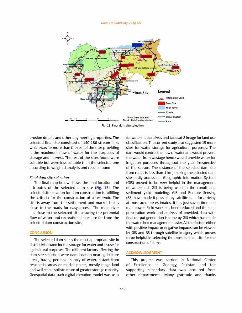
Final dam site selectionThe final map below shows the final location and
attributes of the selected dam site (Fig. 13). The selected site location for dam construction is fulfilling the criteria for the construction of a reservoir. The site is away from the settlement and market but is close to the roads for easy access. The main river lies close to the selected site assuring the perennial flow of water and recreational sites are far from the selected dam construction site.
CONCLUSION
The selected dam site is the most appropriate site in district Malakand for the storage for water and its use for agricultural purposes. The different factors affecting the dam site selection were dam location near agriculture areas, having perennial supply of water, distant from residential areas or market points, mostly range land and well stable soil structure of greater storage capacity. Geospatial data such digital elevation model was uses
for watershed analysis and Landsat-8 image for land use classification. The current study also suggested 15 more sites for water storage for agricultural purposes. The dam would control the flow of water and would prevent the water from wastage hence would provide water for irrigation purposes throughout the year irrespective of the season. The distance of the selected dam site from roads is less than 1 km, making the selected dam site easily accessible. Geographic Information System (GIS) proved to be very helpful in the management of watershed. GIS is being used in the runoff and sediment yield modeling. GIS and Remote Sensing (RS) have made it possible by satellite data for arriving at most accurate estimates. It has just saved time and man power. Field work has been reduced and the data preparation work and analysis of provided data with final output generation is done by GIS which has made the watershed management easier. All the factors either with positive impact or negative impacts can be viewed by GIS and RS through satellite imagery which proves to be helpful in selecting the most suitable site for the construction of dams.
ACKNOWLEDGMENT
This project was carried in National Center of Excellence in Geology, Pakistan and the supporting secondary data was acquired from other departments. Many gratitude and thanks
Fig. 13: Final dam site selection
Fig. 13. Final dam site selection

277
Int. J. Hum. Capital Urban Manage., 3(4): 265-278, Autumn 2018
to Dr. Muhammad Shafique form guidance and supervision of this work. Gratitude to the students of Arid Agriculture University, Rawalpindi, Pakistan and Khyber Pukhtunkhwa Wildlife Department, Pakistan for providing support in the study.
CONFLICT OF INTEREST
The author declares that there is no conflict of interests regarding the publication of this manuscript. In addition, the ethical issues, including plagiarism, informed consent, misconduct, data fabrication and/or falsification, double publication and/or submission, and redundancy have been completely observed by the authors.
ABBREVIATIONS
% Percentage
CEC Cation Exchange Capacity
CGIAR Center of Global Innovative Agricultural Research
CGIAR-SCICenter of Global Innovative Agricultural Research- Consortium for Spatial Information
Cm centimeter
cm/m centimeter/meter
cmol/kg centimoles of positive charge per kilogram
DEM Digital elevation model
ds/m deciSiemens per metre
GDP Gross domestic product
GIS Geographic Information System
IMSD Integrated Mission for Sustainable Development
kg/dm3 kilogram per cubic decimeter
Km Kilometer
M Meter
MCDA Multi criteria decision analysis
Mm Millimeter
RS Remote Sensing
SRTM Shuttle Radar Topographic Mission
USGS United States Geological Survey
Vol Volume
W Watershed
WD WD stand for world
WISE World soil property estimates for broad-scale modelling
REFERENCESAbushandi, E.; Alatawi, S., (2015). Dam site selection using remote
sensing techniques and geographical information system to control flood events in Tabuk City. Hydro. Cur. Res., 6(1): 1–13 (13 pages).
Adinarayana, J.; Krishna, N.R; Rao, K.G., (1995). An Integrated approach for prioritization of watersheds. J. Environ. Manage., 44(4): 375–384 (10 pages).
Al-Abadi, A.M.; Shahid, S.; Ghalib, H.B.; Handhal, A.M., (2017). A GIS-based integrated fuzzy logic and analytic hierarchy process model for assessing water-harvesting zones in northeastern Maysan governorate, Iraq. Arab. J. Sci. Eng., 42(6): 2487-2499 (13 pages).
Al-Adamat, R.; AlAyyash.; Al-Amoush, H.; Al-Meshan, O.; Rawajfih, Z.; Shdeifat, A.; Al-Harahsheh, A.; Al-Farajat, M., (2012). The combination of indigenous knowledge and geo-Informatics for water harvesting siting in the jordanian Bad. J. GIS., 4: 366-376 (11 pages).
Ashraf, M.; Kahlown, M.A.; Ashfaq, A., (2007). Impact of small dams on agriculture and groundwater development: A case study from Pakistan. Agric. Water Manag., 92(1): 90-98 (9 pages).
Baban, S.M.J; Wan-Yusof, K., (2003). Modelling optimum sites for locating reservoirs in tropical environments. Water Resour. Manage., 17(1): 1–17 (17 pages).
Behera, D.K., (2013). Dams, development and the exclusion of indigenous groups: a case from Odisha1, navigating social exclusion and inclusion in contemporary India and beyond: structures, agents, practices, 167.
Bhattacharya, S.R., (2016). Planning of land and water resources for a small watershed of Mungeli district. Doctoral dissertation, Indira Gandhi Krishi Vishwavidyalaya, Raipur.
Bódis, K.; Monforti, F.; Szabó, S., (2014). Could Europe have more mini hydro sites? A suitability analysis based on continentally harmonized geographical and hydrological data. Renew. Sustainable Energy Rev., 37: 794-808 (16 pages).
Brauman, K.A.; Daily, G.C.; Duarte, T.K.E.; Mooney, H.A., (2007). The nature and value of ecosystem services: an overview highlighting hydrologic services. Annu. Rev. Environ. Resour., 32: 67-98 (32 pages).
Briscoe, J.; Qamar, U.; Contijoch, M.; Amir, P.; Blackmore, D., (2006). Pakistan’s water economy: running dry. Karachi: Oxford University Press.
Brouwer, C.; Prins. K.; Kay. M.; Heibloem, M., (1990). Irrigation water management: irrigation methods, training manual. 5(140).
Butt, A.; Shabbir, R.; Ahmad, S. S.; Aziz, N., (2015). Land use change mapping and analysis using remote sensing and GIS: a case study of simly watershed, Islamabad, Pakistan. The Egypt. J. Remote Sens. Space Sci., 18(2): 251-259 (09 pages).
Chhuon, K.; Herrera, E.; Nadaoka, K., (2016). Application of integrated hydrologic and river basin management modeling for the optimal development of a multi-purpose reservoir project. Water Resour Manag., 30(9): 3143-3157 (15 pages).
Dixon, B.; Uddameri, V.; Ray, C., (2015). GIS and geocomputation for water resource science and engineering. John Wiley & Sons.
Elameen, I.H.E., (2017). Minimization of flash floods water using GIS based water harvesting. Doctoral dissertation, Sudan University of Science Technology.

278
S.H. Raza et al.
Hansjürgens, B.; Droste, N.; Tockner, K., (2016). Neglected values of major water engineering projects: ecosystem services, social impacts, and economic valuation. In Society-Water-Technology Springer International Publishing, 65-78 (14 pages).
Hlásny, T.; Kočický, D.; Maretta, M.; Sitková, Z.; Barka, I.; Konôpka, M.; Hlavatá, H., (2015). Effect of deforestation on watershed water balance: Hydrological modelling-based approach/Vplyv odlesnenia na vodnú bilanciu povodia: Prístup na báze hydrologického modelovania. For. J., 61(2): 89-100 (13 pages).
Go KPK, (2017). Development statistics of Khyber Pakhtunkhwa, bureau of statistics planning & development department, Government of Khyber Pakhtunkhwa.
Jan, A.M., (2012). The emergence and transformation of Batkhela (Malakand) bazaar: ethnic entrepreneurship, social networks, and change in disadvantageous societies.
Jamali, I.A.; Mörtberg, U.; Olofsson, B.; Shafique, M., (2014). A spatial multi-criteria analysis approach for locating suitable sites for construction of subsurface dams in Northern Pakistan. Water Resour. Manage., 28(14): 5157-5174 (18 pages).
Johnson, L.E., (2016). Geographic information systems in water resources engineering. CRC Press.
Kijne, J.W., (2001). Lessons learned from the change from supply to demand water management in irrigated agriculture: a case study from Pakistan. Water Policy. 3(2): 109-123 (15 pages).
Khitam, E.; Al-Maitah, J., (2005). Location of the dams using GIS techniques: a case study of the Hrh-Tasneem Bint Ghazi for technology research station.
Lalika, M.C.; Meire, P.; Ngaga, Y.M., (2015). Exploring watershed conservation and water governance along Pangani River Basin, Tanzania. Land Use Policy., 48: 351-361 (11 pages).
Lehmann, A.; Giuliani, G.; Ray, N.; Rahman, K.; Abbaspour, K.C.; Nativi, S.; Craglia, M.; Cripe, D.; Quevauviller, P.; Beniston, M., (2014). Reviewing innovative Earth observation solutions for filling science-policy gaps in hydrology. J. Hydrol., 518: 267-277 (11 pages).
Morrison, A. C.; Gold, A. J.; Pelletier, M. C., (2016). Evaluating key watershed components of low flow regimes in New England streams. J. Environ. Qual., 45(3): 1021-1028 (8 pages).
Negash, M.; Hassan, S.; Muchie, M.; Girma, A., (2015). Perspectives on the declaration of principles regarding the Grand Ethiopian
Renaissance Dam. The Thinker., 65: 56-61 (6 pages). O’Callaghan, J.F; Mark, D.M., (1984). The extraction of drainage
networks from digital elevation data. computer vision, graphics, and image processing. 27(2): 247.
Petty, T. R.; Noman, N.; Ding, D.; Gongwer, J.B., (2016). Flood forecasting GIS water-flow visualization enhancement (WaVE): A Case Study. J. GIS., 8(06): 692.
Rasooli, A.; Kang, D., (2015). Assessment of potential dam sites in the Kabul River Basin using GIS. Int. J. Adv. Comput. Sci. Appl., 6: 83-89 (7 pages).
Saraswat, C.; Kumar, P.; Mishra, B.K., (2016). Assessment of storm water runoff management practices and governance under climate change and urbanization: An analysis of Bangkok, Hanoi and Tokyo. Environ. Sci. Policy., 64: 101-117 (17 pages).
Singh, L.K.; Jha, M.K.; Chowdary, V.M., (2017). Multi-criteria analysis and GIS modeling for identifying prospective water harvesting and artificial recharge sites for sustainable water supply. J. Clean Production., 142: 1436-1456 (21 pages).
Singh, P.; Gupta, A.; Singh, M., (2014). Hydrological inferences from watershed analysis for water resource management using remote sensing and GIS techniques. The Egypt. J. Remote Sens. Space Sci., 17(2): 111-121 (11 pages).
Stemn, E.; Kumi-Boateng, B.; Sibil, S., (2016). Multi-criteria-GIS based site selection for irrigational reservoir–A case study. Eur. Agrophysical J., 3(1): 1-17 (17 pages).
Terêncio, D. P. S.; Fernandes, L. S.; Cortes, R. M. V.; Pacheco, F. A. L., (2017). Improved framework model to allocate optimal rainwater harvesting sites in small watersheds for agro-forestry uses. J. Hydrol., 550: 318-330 (13 pages).
Wang, G.; Xia, J.; Chen, J., (2009). Quantification of effects of climate variations and human activities on runoff by a monthly water balance model: a case study of the Chaobai River basin in northern China. Water Resour. Res., 45(7).
Wani, S.P.; Sreedevi, T.K.; Reddy, T.V.; Venkateswarlu, B.; Prasad, C.S., (2008). Community watersheds for improved livelihoods through consortium approach in drought prone rain-fed areas. J. Hydrol. Res. Develop., 23(1): 55-77 (23 pages).
Xie, H.; Chen, L.; Shen, Z., (2015). Assessment of agricultural best management practices using models: current issues and future perspectives. Water., 7(3): 1088-1108 (21 pages).
COPYRIGHTS
Copyright for this article is retained by the author(s), with publication rights granted to the IJHCUM Journal.This is an open-access article distributed under the terms and conditions of the Creative Commons Attribution License (http://creativecommons.org/licenses/by/4.0/).
HOW TO CITE THIS ARTICLE
Raza, S.H.; Shafique, M.; Zia-ur-Rehman, M.; Sikandar, A.; Ahmad, N.; Shah, K., (2018). Site selection of water storage based on multi-criteria decision analysis. Int. J. Hum. Capital Urban Manage., 3(4): 265-278.
DOI: 10.22034/IJHCUM.2018.04.01
url: http://www.ijhcum.net/article_34038.html