inspiring geospatial framework for local administrations
TRANSCRIPT

This project is financed bythe European Union and the Republic of Turkey
National Programme for Turkey 2010 – Instrument for Pre-Accession Assistance
INSPIRing Geospatial Framework For Local Administrations
Ali Toksoy, Onur Lenk, Hüseyin Bayraktar, Mahir Güney, Erkan Tın,
Yıldırım Bayar, Yasemin KOÇ
Presented at th
e FIG Congress 2018,
May 6-11, 2018 in
Ista
nbul, Turkey
Outline
➢ Rationale and Context➢ Components of Geospatial Framework➢ Achievements
Driving force is the Local Administrations…
Total 1365 Municipalities
Metropolitan
Municipality
30
Provincial
Municipality
51
District
Municipality
782
Town
Municipality
451
Provincial Special
Administration
51

All municipalities are the main resources and users of spatial data in INSPIRE context
They may have deficiency in financial and human resources which cause delays for establishing appropriategeospatial infrastructure
Motivation

❖ Each municipality must make its own IT investment (i.e. servers, software packages, database etc.), and
❖ Train its own staff❖ Provide ‘standard spatial data’ through ‘standardized services’ for other
stakeholders
Challenges for Local Administrations
✓ …feasibility and cost-benefit considerations shall be taken into account in the development of the implementing rules (INSPIRE D. Article 7 (1))
✓ …public authorities are given the technical possibility to link their spatial data sets and services to the network …where spatial datasets and services comply with implementing rules with regard, in particular, to metadata, network services and interoperability (INSPIRE D. Article 7 ,11
(1),12..)
❖ Ministry of Environment and Urbanization (MoEU) aimed to provide appropriate infrastructure to develop and maintain geospatial elementsthrough cloud system..
Solution
✓ On-demand self service,✓ Broad network access,✓ Resource pooling,✓ Rapid elasticity,✓ Measured service.
National
Municipal
Cost Saving
Extendable System
Effective Human Resource
Standard Data
High Performance
Data Security
System Security
Interoperability
This project is financed bythe European Union and the Republic of TurkeyThis project is co-financed by the European
Union and the Republic of Turkey.
Components and Expected Results
Results to be Achieved
MoEU has increased its own and
other relevant institutions'
capacity for future
implementation of the INSPIRE
Directive.
Raised awareness for
related stakeholders
and decision makers.
More environmentally friendly land planning
has developed in line with the EU
spatial planning approach
Cloud-based
Geospatial
Modules
Training
and
Awareness
raising
LegislationsProcess Modelling
Management
for data sharing
O
TU
P
Spatial Data
Inventory
1 2 3
This project is financed by the European Union and the
Republic of Turkey.
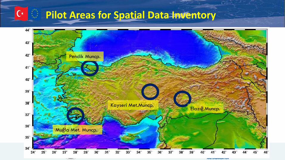
Pilot Areas for Spatial Data Inventory
Kayseri Met.Muncp.Elazığ.Muncp.
Muğla Met. Muncp.
Pendik Muncp.
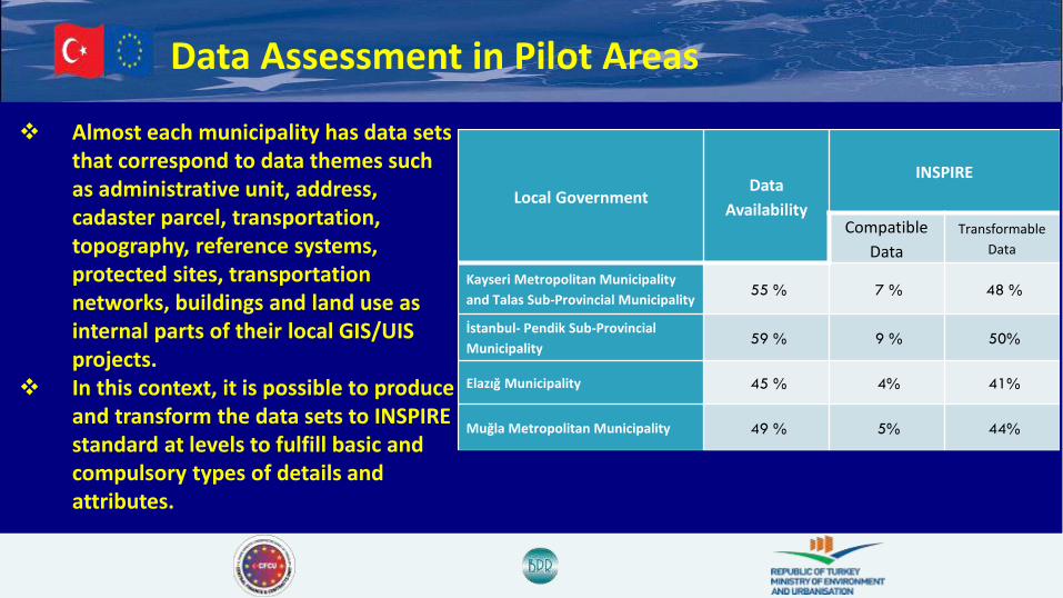
Data Assessment in Pilot Areas
❖ Almost each municipality has data sets that correspond to data themes such as administrative unit, address, cadaster parcel, transportation, topography, reference systems, protected sites, transportation networks, buildings and land use as internal parts of their local GIS/UIS projects.
❖ In this context, it is possible to produce and transform the data sets to INSPIRE standard at levels to fulfill basic and compulsory types of details and attributes.
Local GovernmentData
Availability
INSPIRE
Compatible
Data
Transformable
Data
Kayseri Metropolitan Municipality
and Talas Sub-Provincial Municipality55 % 7 % 48 %
İstanbul- Pendik Sub-Provincial
Municipality 59 % 9 % 50%
Elazığ Municipality 45 % 4% 41%
Muğla Metropolitan Municipality 49 % 5% 44%

Data Assessment in Pilot Areas
Need to be
produced
Available in other
institutions/INSPIRE
-transformable
Available/INSPIRE
transformable
INSPIRE-compatible
Pendik Municipality APPENDIX I-II
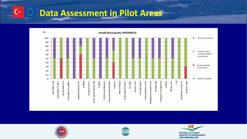
Data Assessment in Pilot Areas
Pendik Municipality APPENDIX III
Need to be produced
Available in other
institutions/INSPIRE-
transformable
Available/INSPIRE
transformable
INSPIRE-compatible
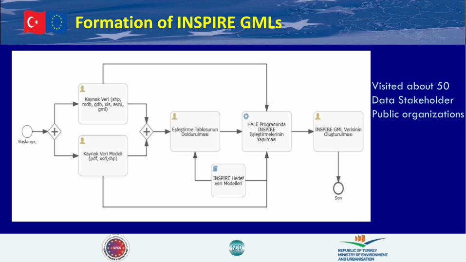
Formation of INSPIRE GMLs
Visited about 50
Data Stakeholder
Public organizations
This project is co-financed by the European
Union and the Republic of Turkey.
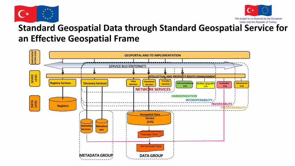
HARMONIZATIONINTEROPERABILITY
INVOKEABLITYDISCOVERABILITY
Registers
MetadataServices
Metadatasets
Registry Services Discovery Servicesi
METADATA GROUP
INTELLECTUAL AND PROPERTY RIGHTS MANAGEMENT
GEOPORTAL AND ITS IMPLEMENTATION
SERVICE BUS İ(İNTERNET)
Transfer Services
Geospatial Data Service
(CVS)
Thematic Data
Harmonized Data
DATA GROUP
ViewServices
DownloadServices
DA
TA
LEV
ELSE
VIC
E LE
VEL
UIM
PLE
MEN
TA
TIO
N L
EVEL
NETWORK SERVICES
HArmonizationşCVS
Birlikte ÇalışabilirCVS
InvokableCVS
DiscoveredCVS
Standard Geospatial Data through Standard Geospatial Service foran Effective Geospatial Frame
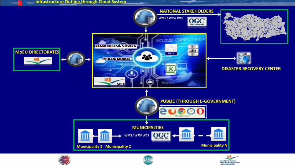
Infrastructure Outline through Cloud System
DATA
WMS / WFS/ WCS
WMS / WFS/ WCS
NATIONAL STAKEHOLDERS
PUBLIC (THROUGH E-GOVERNMENT)
MUNICIPALTIES
MoEU
MoEU DIRECTORATES
Municipality 1 Municipality 2 Municipality N
DISASTER RECOVERY CENTER
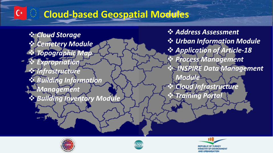
Cloud-based Geospatial Modules
❖ Cloud Storage❖ Cemetery Module❖ Topographic Map❖ Expropriation ❖ Infrastructure❖ Building Information
Management❖ Building Inventory Module
❖ Address Assessment❖ Urban Information Module❖ Application of Article-18❖ Process Management❖ INSPIRE Data Management
Module❖ Cloud Infrastructure ❖ Training Portal

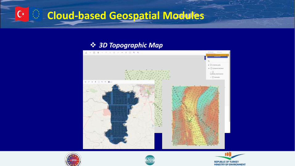
Cloud-based Geospatial Modules
❖ 3D Topographic Map
Cloud-based Geospatial Modules
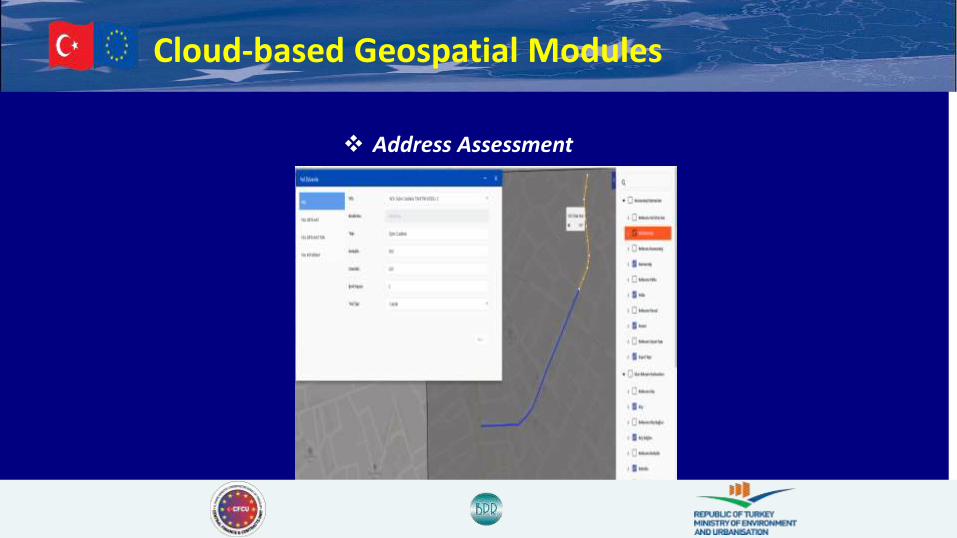
❖ Address Assessment

Cloud-based Geospatial Modules
❖ Application of Article-18

Cloud-based Geospatial Modules
❖ Address Assessment
Cloud-based Geospatial Modules
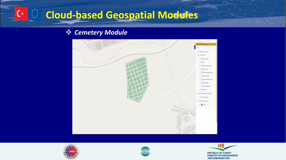
❖ Cemetery Module

Cloud-based Geospatial Modules
❖ Infrastructure
Cloud-based Geospatial Modules
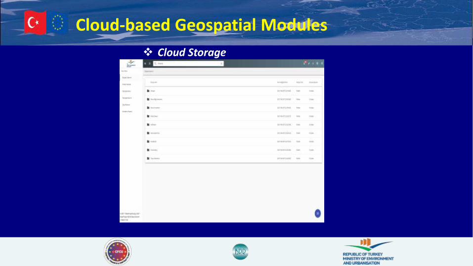
❖ Cloud Storage
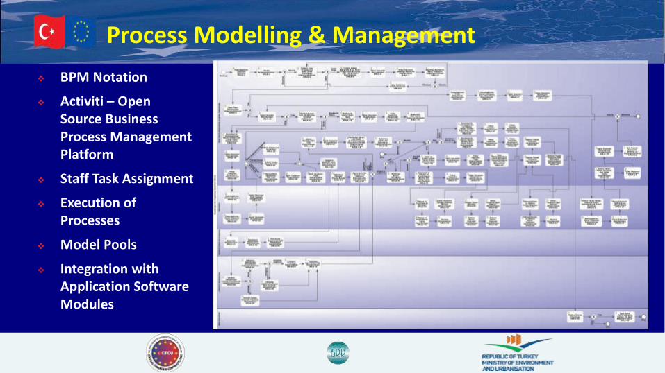
Process Modelling & Management
Objective: Provide a common process management
environment by constructing “To-Be” process
models for Local Governments and putting
these models into service via Process
Modelling and Management Software
running on cloud platform in order to
standardize process flows of institutions,
enable scalability and process optimization.
Target Stakeholders: Local Governments
Provincial Directorates of MoEU
12 Government Institutions
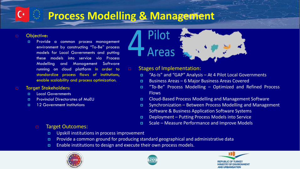
Stages of Implementation: “As-Is” and “GAP” Analysis – At 4 Pilot Local Governments Business Areas – 6 Major Business Areas Covered “To-Be” Process Modelling – Optimized and Refined Process
Flows Cloud-Based Process Modelling and Management Software Synchronization – Between Process Modelling and Management
Software & Business Application Software Systems Deployment – Putting Process Models into Service Scale – Measure Performance and Improve Models
Target Outcomes: Upskill institutions in process improvement Provide a common ground for producing standard geographical and administrative data Enable institutions to design and execute their own process models.
Process Modelling & Management
❖ BPM Notation
❖ Activiti – Open Source Business Process Management Platform
❖ Staff Task Assignment
❖ Execution of Processes
❖ Model Pools
❖ Integration with Application Software Modules

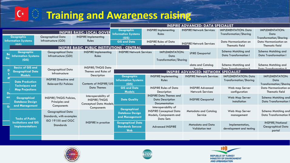
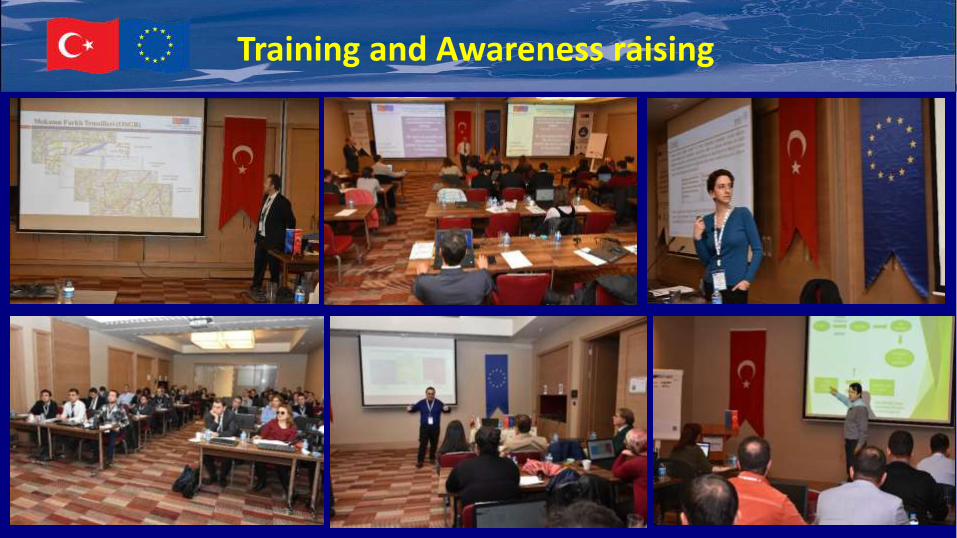
Training and Awareness raising
❖ Training Need Analysis Report Preparedwhere a web-based ‘Survey’ is carried out..
❖ 1890 participants including 651 from Local Administrations.
❖ INSPIRE Training Programs (13 Groups)designed for different profile levels of participants according to the surveyoutputs
Training and Awareness raising
INSPIRE BASIC: LOCAL GOVERNMENTSGeographic
Information Systems
(GIS)
Geographical Data
Infrastructure (GDI)
INSPIRE Implementing
Rules
INSPIRE Network Services IMPLEMENTATION:
Data
Transformation/Sharing
Basics of GIS and
Geographical Data
Models
Geographical Data
Infrastructure
Geographical Data
Standards, with examples
ISO 191XX and OGC
Standards
Metadata Data Harmonization
Data Production
Techniques and
Map Projections
INSPIRE Directive and
Relevant EU PoliciesINSPIRE/UIS Data themes
and Data Description
Documentation
Network ServicesSchema Matching and
Data Transformation I
Geographical
Database Design
and Management
TNGIS/UIS Policies,
Components and Data
Themes
Interoperability of
INSPIRE/UIS Conceptual
Data Models,
Components
Geographic Data PortalSchema Matching and
Data Transformation II
Geographic Data
Analysis and
Presentation
Techniques
UIS Implementations and
Smart Cities INSPIRE in practice
Cloud UIS and
Implementations
Using INSPIRE/National
Geographical Data
Portal
INSPIRE ADVANCED: DATA SPECIALISTGeographic
Information Systems
(GIS)
INSPIRE Implementing
Rules
INSPIRE Network Services IMPLEMENTATION: Data
Transformation/Sharing
IMPLEMENTATION:
Data
Transformation/Sharing
GIS and Data
Models
INSPIRE Rules of Data
DescriptionINSPIRE Network Services
Data Harmonization on
Thematic field
Data Harmonization on
Thematic field
Geographical
Database Design
and Management
NSPIRE Data Themes and
Data Description
Documentation
INSPIRE GeoportalSchema Matching and
Data Transformation I
Schema Matching and
Data Transformation I
Geographical Data
Standards Sensoe
Web
Interoperability of
INSPIRE Conceptual Data
Models, Components and
Data Sets
Metadata and Catalog
Service
Schema Matching and
Data Transformation II
Schema Matching and
Data Transformation II
Tasks of Public
Institutions and GIS
Implementations
Linked data ApproachMetadata and Data
Validation testCloud GIS platform
INSPIRE/National
Geographical Data
portal
INSPIRE BASIC: PUBLIC INSTITUTIONS - CENTRALGeographic
Information Systems
(GIS)
Geographical Data
Infrastructure (GDI)
INSPIRE Implementing
Rules
INSPIRE Network Services IMPLEMENTATION:
Data
Transformation/Sharing
Basics of GIS and
Geographical Data
Models
Geographical Data
Infrastructure
INSPIRE/TNGIS Data
Themes and Rules of
Description
Metadata Data Harmonization
Data Production
Techniques and
Map Projections
INSPIRE Directive and
Relevant EU Policies Contents of INSPIRE/UIS
Data ThemesNetwork Services
Schema Matching and
Data Transformation I
Geographical
Database Design
and Management
INSPIRE/TNGIS Policies,
Principles and
Components
Interoperability of
INSPIRE/TNGIS
Conceptual Data Models,
Components
Geographic Data PortalSchema Matching and
Data Transformation II
Tasks of Public
Institutions and GIS
Implementations
Geographical Data
Standards, with examples
ISO 191XX and OGC
Standards INSPIRE in practice
E-government GIS
Implementations
Using INSPIRE/National
Geographical Data
Portal
INSPIRE ADVANCED: NETWORK SPECIALISTGeographic
Information Systems
(GIS)
INSPIRE Implementing
Rules
INSPIRE Network Services IMPLEMENTATION: Data
Transformation/Sharing
IMPLEMENTATION:
Data
Transformation/Sharing
GIS and Data
Models
INSPIRE Rules of Data
Description
INSPIRE Advanced
Network Services
Web map Server
configuration
Data Harmonization on
Thematic field
Data Quality
INSPIRE Data Themes and
Data Description
Documentation
INSPIRE GeoportalWeb Map Server
installation
Schema Matching and
Data Transformation I
Geographical
Database Design
and Management
Interoperability of
INSPIRE Conceptual Data
Models, Components and
Data Sets
Metadata and Catalog
Service
Web Map Server
management
Schema Matching and
Data Transformation II
Geographical Data
Standards Sensoe
Web
Advanced INSPIREMetadata and Data
Validation test
Implementation,
development and testing
INSPIRE/National
Geographical Data
portal
Training and Awareness raising
Training and Awareness raising
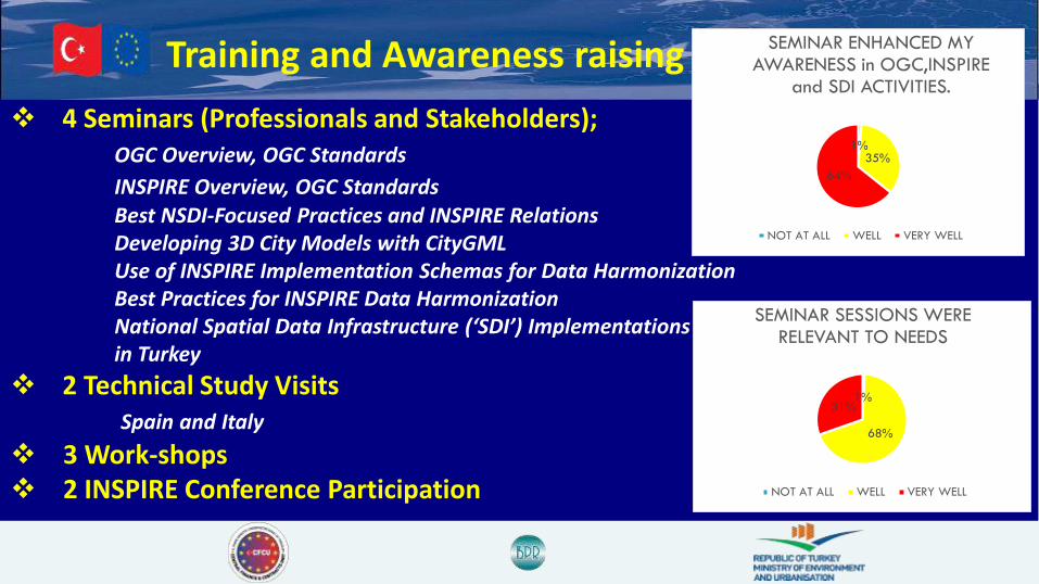
❖ 4 Seminars (Professionals and Stakeholders);OGC Overview, OGC Standards
INSPIRE Overview, OGC StandardsBest NSDI-Focused Practices and INSPIRE RelationsDeveloping 3D City Models with CityGMLUse of INSPIRE Implementation Schemas for Data HarmonizationBest Practices for INSPIRE Data HarmonizationNational Spatial Data Infrastructure (‘SDI’) Implementations in Turkey
❖ 2 Technical Study Visits Spain and Italy
❖ 3 Work-shops❖ 2 INSPIRE Conference Participation
1%
68%
31%
SEMINAR SESSIONS WERE RELEVANT TO NEEDS
NOT AT ALL WELL VERY WELL
1%35%
64%
SEMINAR ENHANCED MY AWARENESS in OGC,INSPIRE
and SDI ACTIVITIES.
NOT AT ALL WELL VERY WELL
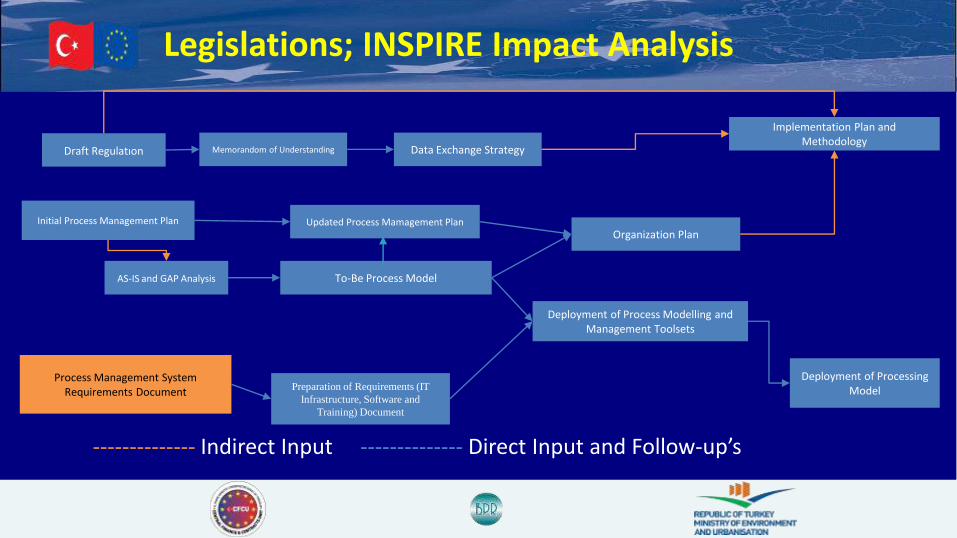
Legislations; INSPIRE Impact Analysis
Draft Regulatıon Memorandom of Understanding
AS-IS and GAP Analysis
Initial Process Management Plan Updated Process Mamagement Plan
To-Be Process Model
Deployment of Processing Model
Organization Plan
Deployment of Process Modelling and Management Toolsets
Process Management System Requirements Document Preparation of Requirements (IT
Infrastructure, Software and
Training) Document
Data Exchange Strategy
Implementation Plan and Methodology
-------------- Indirect Input -------------- Direct Input and Follow-up’s

Legislative Regulation Memorandum of Understanding
Data Exchange Strategy To Be Plan
Organization Plan
Implemetation Plan andMethodology
Regulations and INSPIRE Impact Analysis
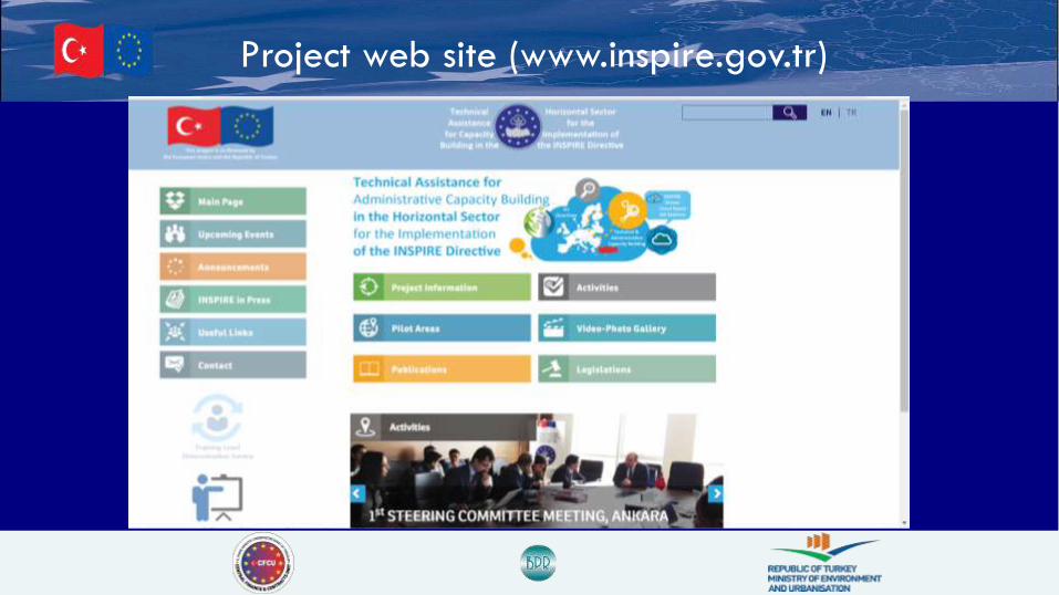
Project web site (www.inspire.gov.tr)

This project is financed by
the European Union and the Republic of Turkey.
This publication has been developed with the financial assistance of the European Union.
The contents of this publication are the sole responsibility of BPR Consulting and can in no way be taken to reflect the views of the European Union.
Onur Lenk ([email protected]) Team Leader (On behalf of Consortium)
Yıldırım Bayar ([email protected]) Department Director ,MoEU (On behalf of Beneficiary)