inside the earth composition (what it is made of) crust (where we live) (hot)mantle (hot) (even...
TRANSCRIPT


Inside the Earth

Composition (What it is made of)
• Crust (where we live)
• Mantle (hot)(hot)
• Outer Core (even hotter)(even hotter)
• Inner Core (HOTTEST)(HOTTEST)


The Four Layers The crustcrust is the layer that you live on and most widely studied and understood. The mantlemantle is much hotter and has the ABILITY TO FLOWABILITY TO FLOW. The outer core and inner outer core and inner corecore are even hottereven hotter with pressures so great you would be squeezed into a ball smaller than a marble if you were able to go to the center of the Earth!

The Crust
• Outer layer• 2 types of crust
– Continental (less less densedense, made of granite)
– Oceanic (very dense, made of basalt)

The Crust
The CRUST is composed of two rocks. The continental crust is mostly granite. The oceanic crust is basalt. Basalt is much denser than the granite. Because of this Because of this the less dense continents ride on the denser oceanic the less dense continents ride on the denser oceanic plates. plates.

Oceanic and Continental Crust

The Lithosphere
The crust and the upper layer of the mantle together make up a zone of rigid, brittle rock called the Lithosphere.

The Mantle
• Middle layer• Very thick layer

The Mantle The Mantle is the largest layer of the largest layer of the EarthEarth. The middle mantle is composed of very hot dense rock that flows like asphalt under a heavy weight. The movement of The movement of the middle mantle the middle mantle ((asthenosphereasthenosphere) is ) is the reason that the the reason that the crustal plates of crustal plates of the Earth move. the Earth move.

The Asthenosphere
The asthenosphereasthenosphere is the semi-rigid part of the middle mantle that flows like hot asphalt under a heavy weight.

The Outer and Inner Core
• Made mostly of iron
• 1/3 of the earth’s mass
• Very hot

Earth’s Layers
• How are the earth’s layers similar to an egg?
• Shell=crust• Egg white=mantle• Yolk=core
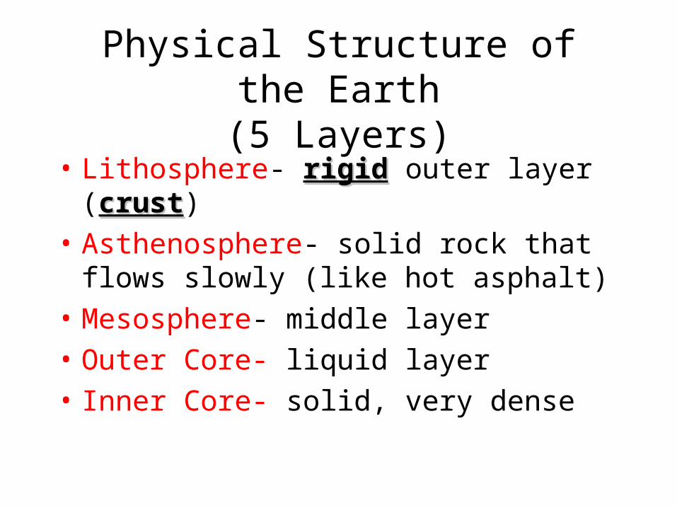
Physical Structure of the Earth(5 Layers)
• Lithosphere- rigidrigid outer layer (crustcrust)
• Asthenosphere- solid rock that flows slowly (like hot asphalt)
• Mesosphere- middle layer
• Outer Core- liquid layer
• Inner Core- solid, very dense


Convection Currents
The middle mantle "flows" because of convection currents. Convection currents are caused by the very hot material at the deepest part of the mantle rising, then cooling and sinking again --repeating this cycle over and over.

Convection Currents The next time you heat anything like
soup or water in a pan you can watch the convection currents move in the liquid. When the convection currents flow in the asthenosphere they also move the crust. The crust gets a free ride with these currents, like the cork in this illustration.
Safety Caution: Don’t get your face too close to the boiling water!

The Outer Core
The core of the Earth is like a ball of very hot metals. The
outer core is so hot that the metals in it are all in the liquid state. The outer core is composed of the melted metals of nickel and iron.

The Inner Core
The inner core of the Earth has temperatures and pressures so great that the metals are squeezed together and are not able to move about like a liquid, but are forced to vibrate in place like a solid.

Movie or animation

Plate Tetonics Defined
• Plate tectonics is the theory that the outer rigid layer of the earth (the lithosphere) is divided into about a dozen " plates" that move across the earth's surface relative to each other, like slabs of ice on a lake


Watch the video NASA Layers of the Earth

Continents
• Click and drag
• http://www.playkidsgames.com/games/continentNames/default.htm#

Continents • the continents are merely the crust exposed above sea
level• the solid surface of the Earth below sea levelbelow sea level is also
crust. • the crust is broken into pieces which are called
"plates." • The continents are the exposed portions of the Earth's
plates. • However, some continents may be composed of the
exposed sections of more than one plate. Therefore "continent" does not equal a plate.

Figure 2. Map showing Earth’s main lithospheric plates and some of the world’s earthquake occurrences (red dots).(From http://www.iris.edu/edu/onepagers/Hi-Res/OnePager2.pdf)

Powering the Movement of Plates • The driving mechanism believed responsible for
plate movement is heat transfer within Earth’s interior. The source of the intense heat powering this great task is radioactivity deep within Earth’s mantle and primordial heat from Earth’s formation.

The movement of the plates is driven by convection cells in the mantle so the plates are continuously jostling against each plates are continuously jostling against each otherother. Geologically, the most important things happen at plate boundaries, including most of the earthquakes, volcanos, igneous rocks, major metamorphism, and mountain building processes. Interplate regions tend to be rather boring.
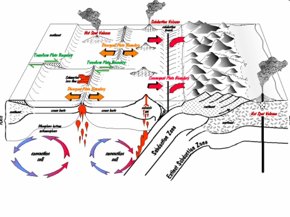

There are three kinds of plate boundaries

• . Divergent boundaries are where plates separate from each other, and magma oozes up from the mantle into the crack (a fissure volcano) making the ocean basin wider. This is known as sea floor spreading.

http://geology.com/nsta/divergent-plate-boundaries.shtml

• When a divergence occurs within a continent it is called rifting. Hot magma rises from deep within the mantle pushing up the crust and causing pressure forcing the continent to break and separate. Lava flows and earthquakes would be seen.


Sea Floor Spreading
• Watch Bill Nye Video on disk

• Convergent boundaries are where plates come together, but to do so one of the plates must dive below the surface into the mantle along a subduction zone. Convergent boundaries produce mountain chains of very large, explosive volcanos (composite type).

• Here crust is destroyed and recycled back into the interior of the Earth as one plate dives under another. These are known as Subduction Zones - mountains and volcanoes are often found where plates converge. There are 3 types of convergent boundaries: Oceanic-Continental Convergence; Oceanic-Oceanic Convergence; and Continental-Continental Convergence.

Oceanic-Continental Convergence

• When an oceanic plate pushes into and subducts under a continental plate, the overriding continental plate is lifted up and a mountain range is created. Even though the oceanic plate as a whole sinks smoothly and continuously into the subduction trench, the deepest part of the subducting plate breaks into smaller pieces. These smaller pieces become locked in place for long periods of time before moving suddenly and generating large earthquakes. Such earthquakes are often accompanied by uplift of the land by as much as a few meters.

Oceanic-Oceanic Convergence

• When two oceanic plates converge one is usually subducted under the other and in the process a deep oceanic trench is formed. The Marianas Trench, for example, is a deep trench created as the result of the Phillipine Plate subducting under the Pacific Plate.
Oceanic-oceanic plate convergence also results in the formation of undersea volcanoes. Over millions of years, however, the erupted lava and volcanic debris pile up on the ocean floor until a submarine volcano rises above sea level to form an island volcano. Such volcanoes are typically strung out in chains called island arcs.

Continental-Continental Convergence

• When two continents meet head-on, neither is subducted because the continental rocks are relatively light and, like two colliding icebergs, resist downward motion. Instead, the crust tends to buckle and be pushed upward or sideways. The collision of India into Asia 50 million years ago caused the Eurasian Plate to crumple up and override the Indian Plate. After the collision, the slow continuous convergence of the two plates over millions of years pushed up the Himalayas and the Tibetan Plateau to their present heights. Most of this growth occurred during the past 10 million years.

• And, transform boundaries where plates slide past each other, ideally with little or no vertical movement. Most transform boundaries are below sea level and so not easy to see. The San Andreas fault in California is a transform boundary.

Transform-Fault Boundaries

• Transform-Fault Boundaries are where two plates are sliding horizontally past one another. These are also known as transform boundaries or more commonly as faults.

• Most transform faults are found on the ocean floor and are generally defined by shallow earthquakes. A few, however, occur on land. The San Andreas fault zone in California is a transform fault. The San Andreas is one of the few transform faults exposed on land. The San Andreas fault zone, which is about 1,300 km long and in places tens of kilometers wide, slices through two thirds of the length of California. Along it, the Pacific Plate has been grinding horizontally past the North American Plate for 10 million years, at an average rate of about 5 cm/yr. Land on the west side of the fault zone (on the Pacific Plate) is moving in a northwesterly direction relative to the land on the east side of the fault zone (on the North American Plate).

ocean-to-continent convergence

ocean-to-ocean convergence

continent-to-continent convergence Examples: subduction zones which occur at deep sea trenches such as the Marianas Trench, and sites of continental collision forming mountain belts, such as the Himalaya Mountains, the Ural Mountains, the Appalachian Mountains, and the Alps.

Animation of convergent plate motion

Transform - where the plates are sliding past one another, such as one sliding to the north and the adjacent plate sliding to the south.Examples: transform faults (easily seen where they cut at right angles to the mid-ocean ridges); includes the San Andreas fault.

Geologic Processes that occur at plate boundaries

PLATE TECTONICS AND THE EARTH'S EVOLUTION
• When the earth originated it contained no continents• There were only a few kinds of igneous rock – rock
made from cooled lava. • Then, due to plate movement…volcanoes formed
island chains • and then these enlarged to form the large continental
masses we live on today.• at convergent and divergent plate boundaries, new
rock is formed due to the magma. • This magma cooled and fractured eventually creating
the continental masses.

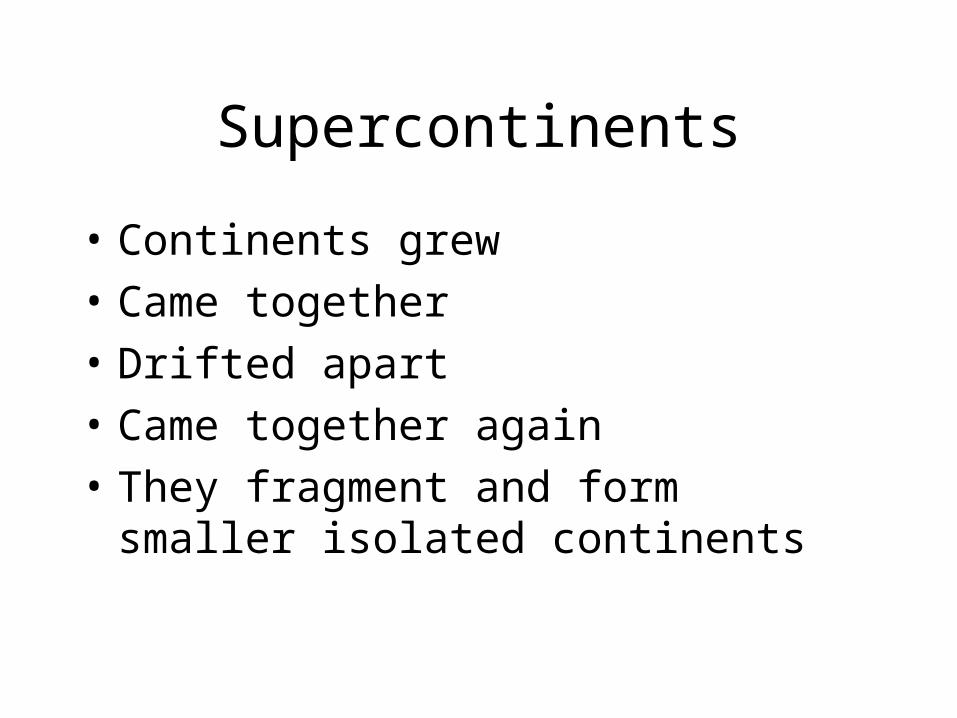
Supercontinents
• Continents grew
• Came together
• Drifted apart
• Came together again
• They fragment and form smaller isolated continents

Pangaea
• The last supercontinent • formed about 300 million years ago when the
isolated continents collided. • During its existence only the one large continent
existed, balanced by one large ocean, Panthalassa. During the fragmentation stage (beginning about 230 million years ago and still going on) the present Atlantic ocean opened up, and all the continents are now scattering across the globe.

Watch pangaea video on disk

• The present day Atlantic ocean is getting wider because of sea floor spreading.
• But since the earth is spherical that means things must be coming together some place else, and that is in the Pacific ocean.
• The Pacific ocean is getting smaller along subduction zones (convergent plate boundaries) under North and South America, and Japan, as western North America and Asia get closer together.

• Sometime in the future the Pacific ocean will close completely and Asia and North America will collide to form another supercontinent.
• The history of Gondwana and Rodinia tell us that this supercontinent will not stay together long either, and will fragment into isolated continents scattered across the earth again.

• The main force that shapes our planet’s surface over long amounts of time is the movement of Earth's outer layer by the process of plate tectonics.


• Movements deep within the Earth, which carry heat from the hot interior to the cooler surface, cause the plates to move very slowly on the surface, about 2 inches per year.

• Interesting things happen at the edges of plates. Subduction zones form when plates crash into each other, spreading ridges form when plates pull away from each other, and large faults form when plates slide past each other.

Rock Evidence for Continental Drift
• There are lots of rocks in Antarctica, but the one that scientists just found is special. It may provide evidence that part of Antarctica was connected to North America hundreds of millions of years ago.


• The rock, made of granite - a common intrusive igneous rock, was found on a glacier in Antarctica by a team of scientists who are trying to figure out how the continents were connected into a large supercontinent named Rodinia hundreds of millions of years ago.

• This rock supports the hypothesis that about 600-800 million years ago part of the supercontinent broke away from what is now the southwestern United States and drifted south to become eastern Antarctica and Australia.

• The rock was taken to laboratories for testing to see if its chemistry was like that of rocks in the US. They found that the rock is very similar to igneous rocks in the United States. Particularly, it is similar to rocks that are found in parts of California, New Mexico, Kansas, and Illinois, as well as New Brunswick and Newfoundland in Canada. The rocks in this area were part of the supercontinent Rodinia.

• Figuring out where continents where hundreds of millions of years ago is a bit like putting a jigsaw puzzle together. The pieces are the continents we have today, but they have been moved from where they used to be because of plate tectonics. By finding rocks on different continents that are made of the same minerals and chemicals, scientists can piece together where the continents used to be located and how they were connected.

Why is the Earth so restless?
What causes the ground to shake violently, volcanoes to erupt with
explosive force, and great mountain ranges to rise to
impressive heights?

• The answers to these questions were discovered as one of sciences’ most revolutionary and recent theories took shape. It began with Alfred Wegener…

Continental Drift
• Alfred Wegener (German Astronomer and Meteorologist) proposed in 1914 that all landmasses were at one time connected as a supercontinent approximately 200 million years ago which he called Pangaea. In Wegener’s theory of continental drift, Pangaea progressively split up as the continents detached themselves and “drifted” away. Wegener provided physical, fossil, geological, and climate evidence to support this theory;

• Fit of the continents
• Wegener noted that the shape of the continent’s coastlines appeared to match like pieces in a jigsaw puzzle.

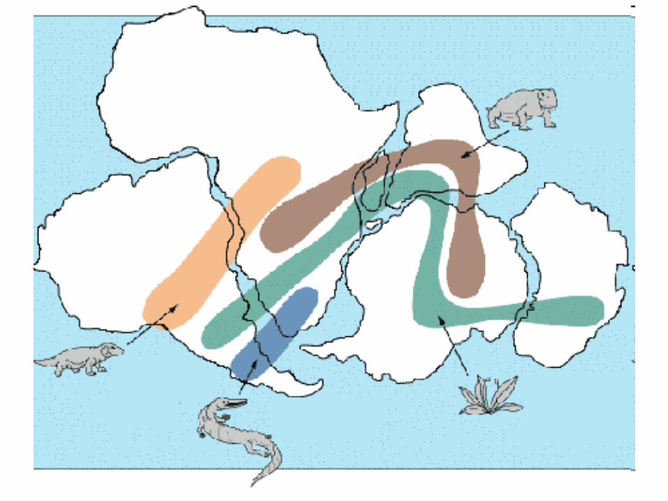
• Fossil evidence (Mesosaurus, Lystrosaurus, Glossopteris)
• Noted the occurrence of plant and animal fossils found on the match coastlines of South America and Africa. (Figure 1)

the locations of certain fossil plants and animals on present-day, widely separated continents would form definite patterns (shown by the bands of colors), if the continents are rejoined. (from http://earthobservatory.nasa.gov/Library/Giants/Wegener/wegener_4.html)

• Rock type and structural correlations
• • Similar age, structure, and rock types on continents on opposite sides of the Atlantic Ocean. i.e. Appalachian Mountains (North America) and mountains in Scotland and Scandinavia
• • Paleoclimatic evidence

• • Found dramatic climate changes on some continents. Most notable was the discovery of coal deposits (made of tropical plants) in Antarctica which led Wegener to conclude that this frozen continent in an earlier time in Earth’s history must have been positioned closer to the equator – where the milder climate allowed lush, swampy vegetation to grow. (Figure 2)

Figure 2: Paleoclimatic evidence for continental drift.(from http://www.geology.ohio-state.edu/~vonfrese/gs100/lect25/index.html)
• Detailed information regarding Wegener’s evidence can be found at;http://pubs.usgs.gov/gip/dynamic/historical.htmlhttp://www.geology.ohio-state.edu/~vonfrese/gs100/lect25/

• The main reason Wegener’s hypothesis was not accepted was because he suggested no mechanism for moving the continents. His belief that the force of Earth’s spin (rotation) was enough to cause the continents to move was not shared by the geologists of the time who knew that rocks were too strong for this to be true.
• For an article outlining the grand vision of drifting continents and widening seas to explain the evolution of Earth’s geography and his theory of continental drift, go tohttp://earthobservatory.nasa.gov/Library/Giants/Wegener/


History of Plate Tetonics
• The idea that continents can move was proposed by Wegener in 1915 on the basis of fossil evidence, the way in which coastlines seemed to fit together, and other features, but it was not widely accepted at the time.

• Evidence that led to the development of plate tectonic theory in the 1960s came primarily from new data from the sea floor, including topography and the magnetism of rocks.

• Seafloor spreading was proposed as a mechanism to drive the movement of the continents on the basis of symmetrical patterns of reversed and normal magnetic rocks on the sea floor.

• The Himalayas are often referred to as the "roof of the world" because they host the highest peaks on earth, most famously Mt. Everest at 8,848 meters above sea level. The rock that caps Mt. Everest is limestone, which forms at the bottom of warm, shallow seas and is composed entirely of fossilized marine creatures, everything from plankton to clams and fish. For years, geologists struggled to explain how the hardened remains of tiny sea organisms could exist at the top of a mountain range.

Permian
225 million years
ago
Jurassic
135 million years
ago
Today


• Geologic events are Earth changes that occur rapidly such as faults, earthquakes and volcanoes

Watch video nasa plate tetonics and fossil
• Volcano short movie on disk

This Dynamic Earth: The Story of Plate Tectonics
by W. Jacquelyn Kious and Robert I. Tilling. An outstanding resource covering the historical perspective, development the theory, understanding plate motion, and plate tectonics and people. It is available as an online edition and as a downloadable PDF edition (77 pages, 3.7MB) at http://pubs.usgs.gov/gip/dynamic/dynamic.html
Plot that Quake!
• The goal of this exercise is to motivate students to question why earthquakes and volcanoes occur where they do. Students plot earthquake data over time in order to discover that a pattern develops in the occurrence of earthquakes worldwide.http://seismo.berkeley.edu/istat/ex_quake_plot/
Berkeley Seismological Laboratory
• This site is a great starting place which contains a worldwide earthquake catalog, along with links to United States seismic data, and a map of California and Nevada earthquakes. http://seismo.berkeley.edu/faq/catalog_0.html
• Link to education and outreach activities,http://seismo.berkeley.edu/iup.overview.html

Earth Science Education
• Professor Larry Braile of Purdue University has complied links with a great deal of activities, simulations, teaching modules, and investigations targeting earthquakes and plate tectonics. http://web.ics.purdue.edu/~braile/educindex/educindex.htm

• IRIS (Incorporated Research Institutions for SeismologyThe IRIS website contains a host of lesson plans and resources for educators along with earthquake maps, lists, and interactive software. To access IRISEducation and Outreach, go to http://www.iris.washington.edu/about/ENO/index.htm

• Southern California Integrated GPS Education ModuleFor simulations showing animated divergent (mid-ocean ridge) boundary, convection in the mantle and seafloor spreading, and convergent (subduction) boundary, go tohttp://scign.jpl.nasa.gov/learn/plate4.htmAssociated activities,http://scign.jpl.nasa.gov/learn/activity.htm

• Earthquakes/tectonicsThis site is a great educational resource, which provides students with numerous links for studying continental drift, plate tectonics, the structure of the Earth, earthquakes, and seismic waves. The following is a link to animations, simulations and additional teaching resources within the science of geology. http://www.scienceman.com/pgs/00_links_geology.html


• http://www.coolschool.ca/content/showcase.php?type=science
Sea Floor Spreading
• Harry Hess (geologist and Navy submarine commander during WWII) studied newly published maps of the seafloor topography indicating the existence of a world-wide mid-ocean ridge system. He proposed, in the 1960’s, that ridges are where new seafloor is created from upwelling in the mantle. It was possible, he stated, that molten magma from beneath the earth’s crust could ooze up between plates and as this hot magma cooled, it would expand and push on either side of it. He also proposed subduction as a mechanism for recycling of the seafloor. His theory provided a mechanism for continental movement that Wegener’s model was lacking.

Volcanoes• Volcanoes can occur where two tectonic plates move against each other or over special
regions called ‘hot spots’.• Eruptions occur when magma rises from the mantle and bursts through the surface of the
Earth to become lava. A main pipe or vent connects the mantle to the crater at the Earth’s surface and other side pipes can also form. How a volcano erupts and the shape of a volcano depends on the magma. For example some magma forms thick lava which flows slowly and doesn’t travel very far before it cools and sets, so it forms steep sided volcanoes. Very thick lava can also ‘clog’ the vent so that pressure builds up and an eruption can be explosive with rocks and clouds of ash being thrown out.
• Hot spots are sources of high heat below the mantle that seem to ‘burn through’ the Earth’s crust at a weak spot. These volcanoes mainly erupt lava with very little ash. This type of volcano is often found on the bottom of the ocean where it continually releases lava that is cooled by the sea. Eventually enough lava is built up to form a small island. The entire chain of Hawaii’s islands was created as a tectonic plate moved slowly over a hot spot.

Earthquakes
• Tectonic plates that form the surface of the Earth slowly move around, but sometimes the jagged edges of plates lock together. Stress builds until something gives and a large amount of energy is suddenly released at a point called the focus. The surface of the Earth immediately above the focus is called the epicentre. The energy travels in all directions through the Earth as seismic waves. Some seismic waves travel quickly and squeeze and stretch the rocks, some waves make the rock move up and down. Other waves cause a circular motion near the surface of the Earth and cause most damage.

• Samples of the deep ocean floor show that basaltic oceanic crust become progressively older as one moves away from the mid-ocean ridge. (Figure 3)

• • The rock making up the ocean floor is considerably younger than the continents – no rock samples older than 200 million years are found in the ocean crust while ages in excess of 3 billion years can be found in continental rocks.


• Paleomagnetism studies of the ocean floor demonstrate that the orientation of the Earth’s magnetic field has changed over time. (Figure 4)

• Figure 4: A theoretical model of the formation of magnetic striping. New oceanic crust forming continuously at the crest of the mid-ocean ridge, cools and becomes increasingly older as it moves away from the ridge crest with the spreading of the seafloor: a. the spreading ridge about 5 million years ago; b. about 2 to 3 million years ago; and c. present-day (from http://pubs.usgs.gov/gip/dynamic/developing.html).For detailed background on ocean floor mapping, magnetic striping and polar reversals, go to http://pubs.usgs.gov/gip/dynamic/developing.html
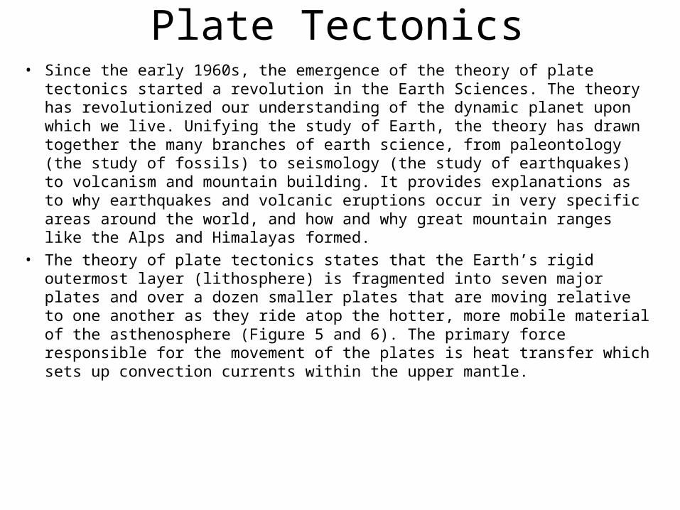
Plate Tectonics• Since the early 1960s, the emergence of the theory of plate tectonics started a
revolution in the Earth Sciences. The theory has revolutionized our understanding of the dynamic planet upon which we live. Unifying the study of Earth, the theory has drawn together the many branches of earth science, from paleontology (the study of fossils) to seismology (the study of earthquakes) to volcanism and mountain building. It provides explanations as to why earthquakes and volcanic eruptions occur in very specific areas around the world, and how and why great mountain ranges like the Alps and Himalayas formed.
• The theory of plate tectonics states that the Earth’s rigid outermost layer (lithosphere) is fragmented into seven major plates and over a dozen smaller plates that are moving relative to one another as they ride atop the hotter, more mobile material of the asthenosphere (Figure 5 and 6). The primary force responsible for the movement of the plates is heat transfer which sets up convection currents within the upper mantle.

Figure 5: The layer of Earth we live on is broken into a dozen or so rigid plates (from http://pubs.usgs.gov/gip/dynamic/slabs.html)

• The boundary between these lithospheric plates is where most of the action (earthquakes) takes place. Three primary plate boundaries exist (Figure 6);
• • Divergent boundaries – where new crust is created as the plates pull away from each other (mid-ocean ridge)• Convergent boundaries – where crust is recycled back into the mantle• Transform boundary – where plates slide horizontally past one another


• Figure 6: Artist's cross section illustrating the main types of plate boundaries (see text); East African Rift Zone is a good example of a continental rift zone. (Cross section by José F. Vigil from This Dynamic Planet -- a wall map produced jointly by the U.S. Geological Survey, the Smithsonian Institution, and the U.S. Naval Research Laboratory.) (from http://pubs.usgs.gov/gip/dynamic/Vigil.html)

• For simulations showing animated divergent (mid-ocean ridge) boundary, convection in the mantle and seafloor spreading, and convergent (subduction) boundary, go to http://scign.jpl.nasa.gov/learn/plate4.htm

Earthquakes
• Hold a wooden pencil at its ends and push up with your thumbs in the middle. The pencil will bend with little stress placed upon it. However, apply too much stress and the pencil snaps – rapidly releasing its stored energy. The rocks of the lithosphere act in a similar manner to the pencil. Due to relative plate motion, rocks of the lithosphere are under considerable stress. An earthquake is a phenomenon that results from the sudden release of stored energy in the Earth’s crust that generates seismic waves. The boundaries between Earth’s plates are where earthquake (and volcano) occurrences are concentrated (Figure 7).

Figure 7: World seismicity map revealing earthquake occurrences are concentrated in zones around the world (from http://earthquake.usgs.gov/regional/world/seismicity/index.php).

• Each and every earthquake generates Primary (P-wave) and Secondary (S-wave) seismic waves. P-waves are compression or longitudinal waves that travel the fastest of all seismic waves. P-waves travel through solids, liquids, and gases. S-waves are shear or transverse waves which travel slower and pass through solids only.

Figure 8: The different types of motion in P and S waves http://www.exploratorium.edu/faultline/basics/waves.html

• For more information the science of earthquakes and characteristics and behavior of seismic waves, go to http://www.earthquake.gov/learning/kids/eqscience.php

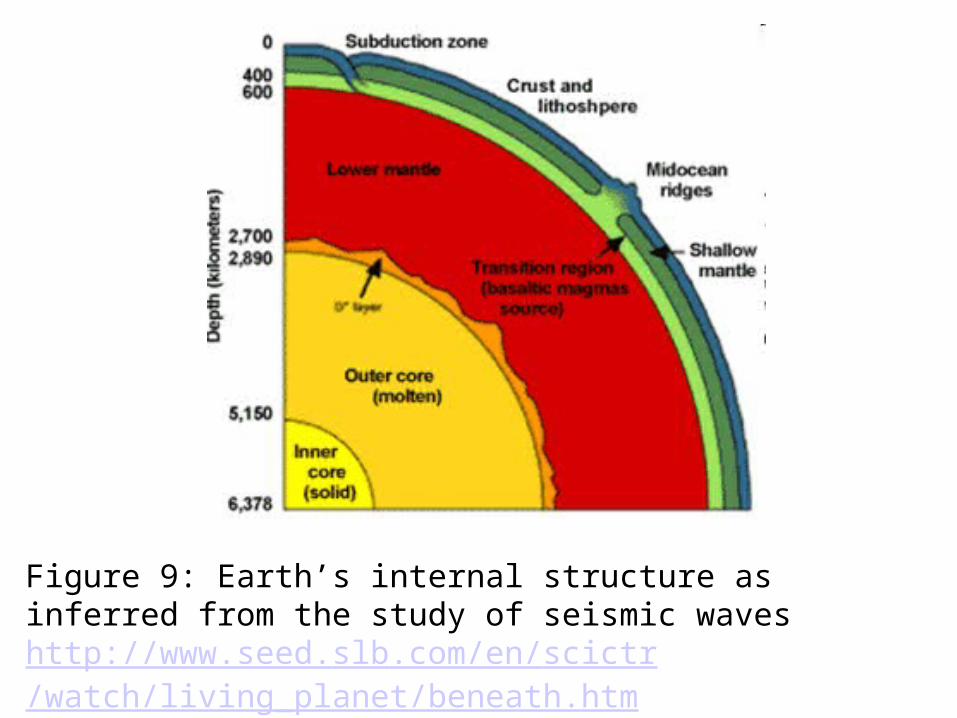
Figure 9: Earth’s internal structure as inferred from the study of seismic waveshttp://www.seed.slb.com/en/scictr/watch/living_planet/beneath.htm

• To learn more about seismic waves and Earth’s interior, go to http://www.solarviews.com/eng/earthint.htm
•USGS facts about earthquakes can be found at, http://earthquake.usgs.gov/learning/kids/facts.php

Common misconceptions associated with this benchmark:
• 1. Students incorrectly believe that the continents randomly drift about the Earth or that the continents are no longer moving.
• Continental Drift, the supercontinent Pangaea, and plate tectonics are likely terms with which students are familiar, however the idea that continents are still on the move today offers a challenge to students and adults. Considering the two timescales involved - human timescale (say 10,000 years of civilization) of observation is far too limited compared to the processes of plate tectonic occurring on a geologic timescale (tens and hundreds of millions of years).
• For more on this and other misconceptions related continental drift visit http://departments.weber.edu/sciencecenter/earth%20science%20misconceptions.htmhttp://k12s.phast.umass.edu/~nasa/misconceptions.html
• For more on slow but continuous change, go tohttp://www.project2061.org/publications/textbook/mgsci/report/Glencoe/GLEN_es2.htm

Common misconceptions associated with this benchmark:
• 2. Students incorrectly believe that California will split apart from the rest of the United States and become an island (or fall into the Pacific Ocean), leaving parts of Southern Nevada with oceanfront property.
• The San Andreas Fault is a transform plate boundary that exists between the North American Plate and the Pacific Plate. This means that the land west of the San Andreas Fault is sliding northwest past the rest of the United States, towards San Francisco. This sliding does not create any space between the two plates for water to fill in, in fact the two plates are actually being pushed together by the two plate’s relative motions as they slide horizontally by each other (VERY slowly).
• For more on this and other misconceptions related to earthquakes go to Earthquake Country Southern California’s website, separating fact from fiction, athttp://www.earthquakecountry.info/10.5/MajorMovieMisconceptions/

Assessment
• 1st Item Specification: Describe how convection in Earth’s mantle has changed the locations and shapes of continents based on tectonic plate movement.

Depth of Knowledge Level 1Use the diagrams below to answer the question.
Which diagram correctly shows how mantle convection currents are most likely moving beneath colliding lithospheric plates?
A. Diagram 1
B. Diagram 2
C. Diagram 3
D. Diagram 4

Which part of Earth’s interior is inferred to have convection currents that cause tectonic plates to move?
A. Rigid mantle
• Asthenosphere
• Outer core
• Inner core

The movement of tectonic plates is inferred by many scientists to be driven by
A. tidal motions in the hydrosphere.
B. density differences in the troposphere.
• convection currents in the asthenosphere.
• olidification in the lithosphere.

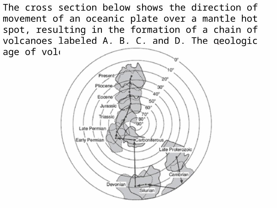
The cross section below shows the direction of movement of an oceanic plate over a mantle hot
spot, resulting in the formation of a chain of volcanoes labeled A, B, C, and D. The geologic
age of volcano C is shown.
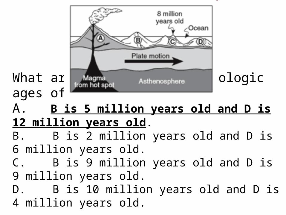
What are the most likely geologic ages of volcanoes B and D?A. B is 5 million years old and D is 12 million years old.B. B is 2 million years old and D is 6 million years old.C. B is 9 million years old and D is 9 million years old.D. B is 10 million years old and D is 4 million years old.
The cross section below shows the direction of movement of an oceanic plate over a mantle hot spot, resulting in the formation of a chain of volcanoes labeled A, B, C, and D. The geologic age of volcano C is shown.

The geographic position of Australia on Earth’s surface has been changing mainly because
A. the gravitational force of the Moon has been pulling on Earth’s landmasses forcing them to move.
B. the tilt of Earth’s axis has changed several times shifting Earth’s landmass
C. Earth’s rotation has spun Australia into different locations.D. temperature differences have been creating convection currents
in Earth’s interior moving landmasses.

2nd Item Specification: Identify the evidence for seafloor
spreading.

• http://www.rpdp.net/sciencetips_v2/E12C2.htm

3rd Item Specification: Identify the three major types of tectonic
plate boundaries.

Diagram 1
Diagram 2 Diagram 3 Diagram 4

Which cross section best represents the crustal plate motion that is the primary cause of the volcanoes and deep rift valleys found at the
mid-ocean ridges?
A. Diagram 1
B. Diagram 2
C. Diagram 3
D. Diagram 4

Which type of plate boundary is shown in the diagram?
A. Divergent
B. Transform
C. Convergent
D. Universal

Which type of plate boundary occurs along the San Andreas Fault?A.TransformB.UniversalC.ConvergentD.Divergent

Base your answers to the question on the map, which shows the location of mid-ocean ridges and the age of some oceanic bedrock near these ridges. Letters A through D are locations on the surface of the ocean floor.

Oceanic bedrock on either side of a mid-ocean ridge is supporting evidence that at the ridges, tectonic plates are
A. diverging.B. convergingC. locked into placeD. being subducted
Common misconceptions associated with this benchmark:
• 3. Students incorrectly believe that Earth’s crust is several 100’s of kilometers thick.
• Earth’s crust consists of two types; continental and oceanic. The less dense continental crust is the thickest, having an average thickness of approximately 30 km while the much thinner and more dense oceanic crust has an average thickness of approximately 5 km. In fact, Earth’s crust occupies less than 1% of Earth’s total volume and represents the extent to which the deepest wells drilled have not exceeded.
• http://www.nagt.org/files/nagt/jge/abstracts/Steer_v53p415.pdf
• For details about Earth’s Interior go to, http://pubs.usgs.gov/gip/dynamic/inside.html