initial report to stratex oil and gas...
TRANSCRIPT
Report prepared by Donald Clark, Ph.D., Senior Geologist, Geoval Consulting, LLC
08 Fall
Hydrocarbon Potential of the Red River, Tyler, and Heath Formations Beneath Stratex Leased Land in Southwestern North Dakota
173 Beach 134th Street office: (917) 558-0746 Belle Harbor, NY 11694 e-mail: [email protected]
Initial report to Stratex Oil and Gas concerning:

[HYDROCARBON POTENTIAL OF THE RED RIVER, TYLER, AND HEATH FORMATIONS BENEATH STRATEX LEASED LAND IN SOUTHWESTERN NORTH DAKOTA] 2
Geoval Consultants LLC Certified Petroleum Geologist
173 Beach 134th Street Belle Harbor, NY 11694
August 25, 2011 Mr. Steve Funk Stratex Oil and Gas IDC 888 Seventh Avenue New York, NY 10106 Stratex Oil and Gas owns acreage in Williston Basin, North Dakota in the Golden
Valley area, containing potential petroleum reservoir targets of three formations with
multiple objectives that have reduced the risk factors significantly.
1. The Tyler Formation; a channel sand—70 to 100 feet thick
2. The Heath Formation; originally rich, thermally mature limestone
3. The Red River Formation; productive in and adjacent fault-block
The petroleum potential is based on hear historic petroleum production. Wells in
the Tyler and the Red River are capable of 300,000 and 199,000 barrels cumulatively.
The potential can only be fully exploited with the proper placement of wells using the
diagenetic and seismic models. The resistivity values of the shale beneath the land
leased by Stratex Oil and Gas are in the 35 ohm-m-range. This value was the value used
to determine if the Bakken shale was mature. If this relationship holds true for the Tyler
formation, then this map suggests that the area leased by Stratex Oil and Gas is
thermally mature and may contain oil. Interestingly, the resistivity of the shale beneath
the land leased by Stratex Oil and Gas is higher than the resistivity values of Billings,
Stark and Slope counties; where significant quantities of oil have been produced from
the Tyler formation. This too, strongly suggests that these shale are thermally mature
[HYDROCARBON POTENTIAL OF THE RED RIVER, TYLER, AND HEATH FORMATIONS BENEATH STRATEX LEASED LAND IN SOUTHWESTERN NORTH DAKOTA] 3
and may have produced oil. Thirty five miles to the north, 83 million barrels of oil has
been produced from the Tyler suggesting widespread organic maturities.
Unconventional drilling techniques, focused on the Heath formation, offer new
potential in this area.
Overall multiple potential pay zones combined with new advances in seismic and
drilling techniques may offer attractive economic potential.
Samuel A. Epstein Certified Petroleum Geologist #3705 Queens, NY 11694

[HYDROCARBON POTENTIAL OF THE RED RIVER, TYLER, AND HEATH FORMATIONS BENEATH STRATEX LEASED LAND IN SOUTHWESTERN NORTH DAKOTA] 4
Table of Contents:
Topic: Page:
1. Red River Formation Overview 5
2. Red River Formation Oil Production
Near Land Leased by Stratex Oil and Gas 10
3. Red River Formation and the Winnipeg Shale as a Rock Source 20
4. Thermal Maturity of the Winnipeg and Red River Source Rocks 20
5. Summary (Red River) 21
6. Tyler Formation Overview 24
7. Tyler Formation Thermal Maturity 30
8. Tyler Formation as a Rock Source 33
9. Heath Formation as a Rock Source 38
10. Summary (Tyler & Heath Formation) 39
11. References 43
12. Supplemental report to Stratex Oil and Gas concerning the Hydrocarbon Potential beneath Stratex leased land in Golden Valley County, North Dakota 44
13. Summary (Supplement) 46

[HYDROCARBON POTENTIAL OF THE RED RIVER, TYLER, AND HEATH FORMATIONS BENEATH STRATEX LEASED LAND IN SOUTHWESTERN NORTH DAKOTA] 5
1. Red River Formation Overview:
The Red River formation in southwestern North Dakota was deposited as shallow
marine and peritidal carbonates during the Ordovician period. The formation is over
700 feet thick in the center of the basin, in Dunn County, North Dakota. The Red River is
divided into both upper and lower parts. The upper unit is further subdivided, in
descending order, into “A”, “B”, “C” and “D” zones (Fig. 1). These zones have been
interpreted to have formed as a series of “shallowing-upward” sequences deposited in
increasingly restrictive environments. Restrictive environments are often anoxic
environments, which is excellent for the preservation of the organic matter that will
later be converted to hydrocarbons. The “A” zone is made up of non-fossiliferous,
laminated dolomitic wackestone and packstone, overlain by a thin anhydrite layer. The
“B” and “C” zones are both made up of a lower burrowed layer containing non-porous,
fossiliferous and bioturbated lime mudstones and wackestones; an overlying laminated
layer composed of porous, microsucrosic dolomite, or a slightly porous, fossiliferous
limestone and a top layer of nodular anhydrite. These anhydrite beds form vertical
caprocks preventing the loss of hydrocarbons. The “D” zone contains beds of black
kerogen rich dolomite, up to 20 cm thick that contain up to 59% total organic carbon.
This kerogen rich dolomite is found throughout the Williston Basin and is thought to be
a source rock for the Red River formation.
Reservoirs in the Red River formation are found where microsucrosic dolomite
has replaced original lime wackestones and packstones, resulting in intercrystalline
porosity. Dolomitization can be highly localized and may produce zones of high quality
reservoir rock that are separated from each other by zones of impermeable rock, this is
especially true in the “C” zone. Some of these dolomitized zones can be up to a
hundred feet in thickness and up to a mile in diameter, which would form an excellent
hydrocarbon reservoir. Hydrocarbons have been produced from all four of these layers,
but mainly from the “B”, “C” and “D” layers.

[HYDROCARBON POTENTIAL OF THE RED RIVER, TYLER, AND HEATH FORMATIONS BENEATH STRATEX LEASED LAND IN SOUTHWESTERN NORTH DAKOTA] 6
Fig. 1. Red River well log from Bowman County, North Dakota. This well is approximately 50 miles to the south of the land leased by Stratex Oil and Gas. Porosity in the “B” and “C” zones is in the mid to upper 20% range. Porosity in the “D” zone is as high as 20%. Vertical wells in this area are drilled to depths of approximately 8,200 feet. Anhydrite layers on top of the porous zones act as vertical seals preventing the vertical loss of hydrocarbons. These porous zones are widespread and extend to the land leased by Stratex Oil and Gas.
Source: Montgomery, 1997.

[HYDROCARBON POTENTIAL OF THE RED RIVER, TYLER, AND HEATH FORMATIONS BENEATH STRATEX LEASED LAND IN SOUTHWESTERN NORTH DAKOTA] 7
The “B” porosity zone is a particularly important reservoir in the Red River
formation since it is laterally pervasive over much of the Williston Basin (Fig. 2 and 3).
The pervasive nature of this porosity zone strongly suggests that it is also present
beneath the land leased by Stratex Oil and Gas. The lateral extent of the “C” porosity
zone is variable and strongly affected by the type of dolomitization that has occurred
within it. Production from and surrounding the land leased by Stratex Oil and Gas
comes mainly from the “B” zone from the following oil fields; the Bull Run field in T136N
R106W; the Williams Creek field in T137N R106W; the Cash field in T135N R106W and
the Cannonball field in T135N R106W (Table 1).
Table 1: Red River oil production from wells on and immediately adjacent to the land leased by Stratex Oil and Gas. The Bull Run field is on Stratex land, the Williams Creek field is just to the north and just to the west of Stratex land, the Cash and Cannonball fields are just to the south of Stratex land. See figure 2 for well locations.

[HYDROCARBON POTENTIAL OF THE RED RIVER, TYLER, AND HEATH FORMATIONS BENEATH STRATEX LEASED LAND IN SOUTHWESTERN NORTH DAKOTA] 8
Fig. 2. The locations of the areas (stippled areas) in Bowman County where horizontal drilling in the Red River “B” porosity zone yielded good results. The land leased by Stratex Oil and Gas is just to the north (20 to 35 miles) of this land. Oil has been produced from the following fields on and around the land leased by Stratex oil and Gas; BR = Bull Run; WC = Williams Creek field (T137N R106W) Cash = Cash field (T135N R106W) and Cannon = Cannonball field (T135N R106W). See table 1 for volumes of hydrocarbons produced. The cross section of line A-A’ is found in figure 3. Source: Montgomery, 1997.

[HYDROCARBON POTENTIAL OF THE RED RIVER, TYLER, AND HEATH FORMATIONS BENEATH STRATEX LEASED LAND IN SOUTHWESTERN NORTH DAKOTA] 9
Fig. 3. Well logs from line A – A’ in figure 2 showing the lateral pervasive nature of the “B” porosity zone in the Red River formation. The pervasive nature of this porosity zone strongly suggests that it extends northward into the land leased by Stratex Oil and Gas. Productive oil fields in and around the land leased by Stratex Oil and Gas also strongly suggest that this is the case. The “C” and “D” porosity zones also form important reservoirs in the Red River formation, but are more heterogeneous in nature. Source: Montgomery, 1997.
[HYDROCARBON POTENTIAL OF THE RED RIVER, TYLER, AND HEATH FORMATIONS BENEATH STRATEX LEASED LAND IN SOUTHWESTERN NORTH DAKOTA]
10
2. Red River Formation Oil Production Near Land Leased by
Stratex Oil and Gas
Understanding how and why oil was produced from the Red River porosity zones,
particularly the “B” zone, both in and around the land leased by Stratex Oil and Gas will help
Stratex Oil and gas plan and exploration strategy for its land. The “B” porosity zone in the
southern part of the Williston Basin is usually around 10 feet thick. The upper part of the
“B” zone tends to have lower porosity, but higher permeability and a higher degree of oil
saturation, when compared to the lower part of the “B” zone, making it the preferred target
for oil exploration.
Traditionally, seismic work was done in southwestern North Dakota to identify
structural highs, which were then drilled with vertical wells. These structural highs are
usually low relief highs, usually less than 100 feet, and fairly small, up to a mile in diameter.
The Bull Run, Williams Creek, Cash and Cannonball fields were all discovered and produced
using this technology (Figs. 4, 5 and 6). The gentle (<1o) regional dip of the Red River in
Southwestern North Dakota is to the northeast, as a result, oil migrating updip (from the
northwest) will become trapped in both structural and stratigraphic traps. Structural traps
(structural highs) and stratigraphic traps have both produced oil from the “B”, “C” and “D”
zones. Structural traps are usually water drive reservoirs; stratigraphic traps are usually
depletion drive reservoirs. Anhydrite beds form excellent cap rocks preventing the vertical
loss of hydrocarbons from these traps. Oil, taken from the Williams Creek field had an API
value of 34, indicating that the sediments are thermally mature, so thermal maturity is not
as great an issue as it is with shallower formations, where the sediments may have only
reached a low level of thermal maturity, or may not have reached thermal maturity.
The structural highs in Bowman County, 20 to 40 miles directly south of land leased
by Stratex Oil and Gas, are much like the ones described above, in Golden Valley County.
They have low relief and are relatively small in diameter. The stratigraphic traps in the “D”
zone in the Horse Creek and South Horse Creek fields are in dolomite lenses that have
impermeable limestone updip, acting as an updip seal (Fig. 2 and 7).

[HYDROCARBON POTENTIAL OF THE RED RIVER, TYLER, AND HEATH FORMATIONS BENEATH STRATEX LEASED LAND IN SOUTHWESTERN NORTH DAKOTA]
11
Fig. 4. The Bull Run Oil field on the land leased by Stratex Oil and Gas. This is a structural contour map of the top of the Red River formation indicating two areas of structural highs, one in section 23 and the other in section 25. Solid circles indicate producing well, open circles indicate dry holes. The True Oil 33-23 Stark and Hess 1-25 Northrup wells were productive (see table 1 for production details). Wells produced from the Red River “B” porosity zone at a depth of approximately 10,360 feet. Source: NDIC oil and gas division, 2011.

[HYDROCARBON POTENTIAL OF THE RED RIVER, TYLER, AND HEATH FORMATIONS BENEATH STRATEX LEASED LAND IN SOUTHWESTERN NORTH DAKOTA]
12
Fig. 5. The Williams Creek Oil field, located just to the north and west of the land leased by Stratex Oil and Gas. This is a structural contour map of the top of the Red River formation (in feet below sea level, depth below the land surface approximately 10,450 feet) indicating a structural high, in section 22, on an upthrown fault block (horst). Solid circle indicates producing wells. The Kremers 21-22 and Gearey #1 wells were productive from the Red River “B” porosity zone, See table 1 for production details. Source: NDIC oil and gas division, 2011.

[HYDROCARBON POTENTIAL OF THE RED RIVER, TYLER, AND HEATH FORMATIONS BENEATH STRATEX LEASED LAND IN SOUTHWESTERN NORTH DAKOTA]
13
Fig. 6. The Cannonball Oil field, located just to the south of the land leased by Stratex Oil and Gas. This is a structural contour map of the top of the Red River formation (in feet below sea level, depth below the land surface approximately 9,650 feet) indicating a structural high, in section 26. The Tennant #A-1 well was productive from the Red River “B” interval, See table 1 for production details. Source: NDIC oil and gas division, 2011.

[HYDROCARBON POTENTIAL OF THE RED RIVER, TYLER, AND HEATH FORMATIONS BENEATH STRATEX LEASED LAND IN SOUTHWESTERN NORTH DAKOTA]
14
Fig. 7. Map showing the distribution of oil fields and oil wells in Bowman County, 20 to 40 miles south of the land leased by Stratex Oil and Gas. Horizontal wells are primarily drilled with a northeast azimuth (20o – 45o). A fault and accompanying fracture zone, downdip and parallel to the Cedar Creek anticline, is intersected by horizontal wells resulting in higher well recovery (see figure 8 for location of excellent versus poor performing wells). Source: Montgomery, 1997.

[HYDROCARBON POTENTIAL OF THE RED RIVER, TYLER, AND HEATH FORMATIONS BENEATH STRATEX LEASED LAND IN SOUTHWESTERN NORTH DAKOTA]
15
Fig. 8. The locations of excellent and poor performing wells in Bowman County and their relationship to the northwest-southeast trending fault through the area. Excellent producing wells are closer to the fault and accompanying fracture zone, which acts as a conduit for oil migration to the well. Source: Montgomery, 1997.

[HYDROCARBON POTENTIAL OF THE RED RIVER, TYLER, AND HEATH FORMATIONS BENEATH STRATEX LEASED LAND IN SOUTHWESTERN NORTH DAKOTA]
16
In the mid 1990’s, horizontal drilling techniques were used to produce oil from
areas that previously were considered uneconomical to produce. A major area for using
horizontal drilling techniques in the Red River formation was in Bowman County 20 to
40 miles directly south of the land leased by Stratex Oil and Gas (Fig. 2, 7 and 8). Decline
rates for many horizontal wells in the Red River formation are in the 30% to 45% range.
It is important to note that the best producing wells were closest to the fault and
accompanying fracture zone. Montgomery (1997) indicated that many of these wells
had annual decline rates that averaged 5%, as opposed to the 30% to 45% decline rates
seen elsewhere, suggesting that oil production was supported by mobile oil moving
toward the well bore. The fracture zones associated with the fault in this area is the
most probable explanation as to the existence of mobile oil. These fractures act as
conduits for fluid flow, in this case oil, which allowed the wells to drain larger areas than
they would have from unfractured bedrock. Figures 9 and 10 illustrates the relationship
between fractures and faults in carbonate bedrock and illustrates how these fractures
can act as conduits for fluid flow perpendicular to a horizontal well bore for better oil
recovery.
The Williams Creek field, just to the north and west of the land leased by Stratex
Oil and Gas was drilled on an upthrown fault block (Fig. 5 and 11). The presence of this
northwest-southeast trending fault makes the land to the southeast of this field similar
to the land in Bowman County that has some very productive horizontal wells drilled
perpendicular to the fault axis (Figs. 7 and 8). If this fault extends to the southeast, into
the land leased by Stratex Oil and Gas, then this area may be very productive as well and
should be one of the first areas targeted for exploration. In addition, if sections 25, 26,
35 and 36 are available in T137N - R106W, consideration should be given to leasing
them if the fault does pass through them.

[HYDROCARBON POTENTIAL OF THE RED RIVER, TYLER, AND HEATH FORMATIONS BENEATH STRATEX LEASED LAND IN SOUTHWESTERN NORTH DAKOTA]
17
Fig. 9. Fracture gradient zones parallel to a normal fault in the Sauk Sequence carbonates of eastern New York State. Zones A, B and C, have a decreasing amount of fracturing with distance from the fault. Zone D is the relatively unfractured bedrock surrounding the fault and fracture zone. Fractures tend to be parallel or subparallel to the fault. Fracture zones extend for 8 to 25 meters (24 to 75 feet), perpendicular to the fault, on either side of the fault zone. It is anticipated that a similar network of fracture zones are present around the faults that are found in the Red River carbonates of southwestern North Dakota. Source: Clark and Friedman, 2005.

[HYDROCARBON POTENTIAL OF THE RED RIVER, TYLER, AND HEATH FORMATIONS BENEATH STRATEX LEASED LAND IN SOUTHWESTERN NORTH DAKOTA]
18
Fig. 10. A cross section of the Sauk Sequence carbonates of eastern New York State showing the development of fault and fracture zones. Present day east is to the right. Fractures tend to form prior to faulting (fault process zones) and are parallel or subparallel to the fault zones. Fracturing continues during movement along the fault plane. Fracture zones extend for 8 to 25 meters (24 to 75 feet) on either side of the fault zone. These fractures can act as conduits for hydrocarbon flow to horizontal wells drilled perpendicular to the fault and fracture zones. It is anticipated that a similar network of fracture zones are present around the faults that are found in the Red River carbonates of southwestern North Dakota. Source: Modified from Clark and Friedman, 2005.

[HYDROCARBON POTENTIAL OF THE RED RIVER, TYLER, AND HEATH FORMATIONS BENEATH STRATEX LEASED LAND IN SOUTHWESTERN NORTH DAKOTA]
19
Fig. 11. The land leased by Stratex Oil and Gas is highlighted in yellow. If the fault in the Williams Creek field (fig. 5) extends to the southeast, through the land leased by Stratex Oil and Gas, then this land may be similar to the land in Bowman County where horizontal wells through the “B” zone are productive (figs. 7 and 8). If a fault is present, horizontal drilling with a northeast azimuth will run through the fault and fracture zone, perpendicular to the fracture zone, increasing the amount of oil available to the wells. Source: Modified from NDIC oil and gas division, 2011.

[HYDROCARBON POTENTIAL OF THE RED RIVER, TYLER, AND HEATH FORMATIONS BENEATH STRATEX LEASED LAND IN SOUTHWESTERN NORTH DAKOTA]
20
3. Red River Formation and the Winnipeg Shale as a Source Rock
There may be several source rocks for the Red River formation reservoirs. Dow
(1974) has indicated that the Ordovician Winnipeg shale has been geochemically
identified as the source of the oil in the Red River formation. This shale is about 100
feet thick beneath the land leased by Stratex Oil and Gas. The Winnipeg shale is
vertically below the Red River formation and migration of oil from the Winnipeg into the
Red River is thought to have occurred through fracture and fault zones. This may be
one of the reasons that the Cedar Creek anticline, the fault downdip and parallel to the
Cedar Creek anticline in Bowman County and the Williams Creek field in Golden Valley
County all produce oil. These faults and the fracture zones associated with these faults
act as pathways for the vertical migration of oil.
In addition to the Winnipeg shale, the black kerogen rich dolomite in the “D”
zone, whose beds are up to 20 cm thick may be a source of hydrocarbons. The total
organic carbon within these beds is up to 59%. This kerogen rich dolomite is found
throughout the Williston Basin.
4. Thermal Maturity of the Winnipeg and Red River Source Rocks
Both the Red River and the Winnipeg source rocks are buried to depths in excess
of 9,000 feet. This depth of burial insures that these formations have reached a depth
where thermal maturity is not an issue regarding the formation of hydrocarbons.
[HYDROCARBON POTENTIAL OF THE RED RIVER, TYLER, AND HEATH FORMATIONS BENEATH STRATEX LEASED LAND IN SOUTHWESTERN NORTH DAKOTA]
21
5. Summary
1) The Red River formation in southern North Dakota has multiple porosity zones
that have all produced oil and natural gas. Some of these porosity zones have produced
oil in and around the land currently leased by Stratex Oil and Gas. Porosity within these
zones ranges from 6% to 25%.
2) Of these multiple porosity zones, the “B” zone is the most pervasive and
should be present under most of the land leased by Stratex Oil and Gas. The “B” zone
tends to be 10 feet thick in southern North Dakota. Production usually comes from the
upper section of the “B” zone, where permeability and oil saturation are higher than in
the lower section.
3) Horizontal drilling normal to a fault zone in Bowman County, 20 to 40 miles
south of the land leased by Stratex Oil and Gas, has produced some relatively high
production wells in the “B” zone that have a lower rate of decline than horizontal wells
drilled through unfractured bedrock.
4) The fault that runs through the Williams Creek field may extend through the
land leased by Stratex Oil and Gas. If this is the case, then the land leased by Stratex Oil
and Gas may be successfully developed using horizontal drilling through the “B” zone, as
was done in Bowman County to the south.
5) Porosity zones “C” and “D” are not as pervasive as the “B” zone, but are
attractive targets where dolomitization has produced porous zones.
6) Anhydrite layers vertically above all the porosity zones act as barriers to the
vertical loss of hydrocarbons from these layers.
7) Updip migration (northwest to southeast) of hydrocarbons from deeper in the
basin (Dunne County) has resulted in the collection of both oil and natural gas in both
structural and stratigraphic traps. These traditional objectives, the structural and
stratigraphic traps, should also be objectives for exploration work performed by Stratex
Oil and Gas.

[HYDROCARBON POTENTIAL OF THE RED RIVER, TYLER, AND HEATH FORMATIONS BENEATH STRATEX LEASED LAND IN SOUTHWESTERN NORTH DAKOTA]
22
8) Seismic work can, and should be used to try and identify structural highs in the
Red River formation under the land leased by Stratex Oil and Gas. Seismic work should
also be used to determine if the Williams Creek fault runs through Stratex land.
9) Fault and fracture zones may act as vertical migration pathways for oil coming
from deeper formation (Winnipeg shale or the “D” zone kerogen rich dolomite.
Potential limitations to economic hydrocarbon production from the Red River
formation beneath the land leased by Stratex Oil and Gas include…
1) Reservoir heterogeneity in the “C” and “D” porosity zones may act to
compartmentalize reservoirs within these layers.
2) Water may be trapped in structural highs and may take up space that could
hold oil and natural gas.
3) Faulting and fracturing may have breached the anhydrite seals allowing
hydrocarbons to vertically escape.
4) The fault that is present in the Williams Creek field does not extend to the
land leased by Stratex Oil and Gas.
Concerning potential limitation #1: The “B” zone is known to be very pervasive
throughout the basin and should be the first objective for any exploration beneath the
land leased by Stratex Oil and Gas. If subsequent exploration work is done in the “C”
and “D” zones, well log information can help to determine where any low porosity and
permeability zones are. In addition, horizontal drilling may act to bypass any low
porosity and permeability zones and link good reservoir rock together.
Concerning potential limitation #2: Water has been found to occupy some
structural traps in the Williston basin and there is always the possibility that a well will
hit water instead of hydrocarbons during exploration drilling. It should be noted
though, that there are a significant amount of structural and stratigraphic

[HYDROCARBON POTENTIAL OF THE RED RIVER, TYLER, AND HEATH FORMATIONS BENEATH STRATEX LEASED LAND IN SOUTHWESTERN NORTH DAKOTA]
23
traps close to the land leased by Stratex Oil and Gas that hold oil and natural gas, so
clearly oil and natural gas migrating updip has displaced water (due to differences in
density) in many structural highs.
Concerning potential limitation #3: Anhydrite seals are high quality, ductile seals
that are preventing vertical loss of hydrocarbons in many Red River fields in the
Williston Basin. The ductile nature of the anhydrite strongly suggests that faulting has
not breached the seal to any great degree in this area.
Concerning potential limitation #4: Seismic work is suggested to determine if
the fault does extend into the land leased by Stratex Oil and Gas. It should be noted
that other fault zones may exist beneath the leased land.

[HYDROCARBON POTENTIAL OF THE RED RIVER, TYLER, AND HEATH FORMATIONS BENEATH STRATEX LEASED LAND IN SOUTHWESTERN NORTH DAKOTA]
24
6. Tyler Formation Overview:
The Tyler formation in North Dakota is made up of a lower unit and an upper
unit. The lower unit is composed of sandstones, siltstones, shales and thin coal beds.
The upper unit is broken down into two subunits, the lower subunit is composed of
argillaceous limestone and calcareous shales whereas the upper subunit is composed of
calcareous shales, anhydritic limestone and anhydrite beds. The lower unit was
deposited on a progradational delta plain, whereas the upper unit was deposited as an
east-west trending delta front and a series of barrier islands.
The argillaceous dark gray limestones, calcareous shales and algal mats in the
lower subunit of the upper Tyler indicate shallow marine and sometimes restrictive and
possibly anoxic shallow marine conditions. The upper subunit of the upper Tyler
contains grayish red, anhydritic lime mudstones reddish brown calcareous shales and
thin beds of anhydrite. The reddish coloration and the anhydrite indicate shallow,
oxygenated and highly evaporitic conditions. The well sorted, white to light gray
sandstone near the base of the upper Tyler has been identified as barrier island sands
and typically appear as lensoid bodies that are 10 to 15 feet thick. These sands are
referred to as the “Fryburg” pay sands (Fig. 12).
Northward progradation of this system during the Pennsylvanian would suggest
that additional barrier islands would be found to the north of the existing reservoirs
found in central portion of Golden Valley and Billings counties and the upper portion of
Stark county. The land leased by Stratex is to the south of the existing east-west
trending barrier island complex that contains the Square Butte, Medora, Fryburg, Zenith
Green River and Dickenson fields (Fig. 13). For this reason I would concentrate
exploratory efforts on the lower unit of the Tyler formation.

[HYDROCARBON POTENTIAL OF THE RED RIVER, TYLER, AND HEATH FORMATIONS BENEATH STRATEX LEASED LAND IN SOUTHWESTERN NORTH DAKOTA]
25
Fig.12. Typical well log for the Tyler formation of southwestern North Dakota. The top of Tyler formation beneath the land leased by Stratex Oil and Gas is approximately 7,500 to 8,000 feet below the land surface. The sandstone in the lower subunit of the upper Tyler unit is the “Fryburg” pay zone (barrier island sands). The upper sandstone layer in the lower Tyler unit is the productive “Fritz” pay zone in the Rocky Ridge field (filled in incised valley). This sand layer has the potential for oil in the land leased by Stratex Oil and Gas if an incised valley is found beneath the property. In the Rocky Ridge field, the pay sands are at a depth of approximately 7,850 feet. Source: Nesheim and Nordeng, 2010

[HYDROCARBON POTENTIAL OF THE RED RIVER, TYLER, AND HEATH FORMATIONS BENEATH STRATEX LEASED LAND IN SOUTHWESTERN NORTH DAKOTA]
26
Fig.13. Map of southwestern North Dakota showing the east-west linear trend of the oil fields (Square Butte to Dickinson Fields) found in the barrier island sands, the Fryburg sands; the northwest-southeast linear Rocky Ridge field containing the in-filled incised valley sands, the Fritz sands, and the location (shaded) of the majority of the land leased by the Stratex Oil and Gas Co. It is important to note that the leased land is south of the east-west trending barrier island complex, but along the same latitude as the Rocky Ridge field, which is approximately 25 to 30 miles to the east. Source: Sturm, 1987.

[HYDROCARBON POTENTIAL OF THE RED RIVER, TYLER, AND HEATH FORMATIONS BENEATH STRATEX LEASED LAND IN SOUTHWESTERN NORTH DAKOTA]
27
The lithology of the lower unit of the Tyler formation is highly variable due to the
geologically rapid rate of change in the delta plain environment. The shales in the lower
Tyler vary in color from red to orange, indicating an oxygen rich environment, to dark gray
to black, indicating an anoxic environment. Organic rich muds, peat and coal landward of
the barrier island complex indicate an estuarine to lagoonal environment.
The Tyler formation was deposited during a time when there was a cyclic rise and
fall in the Tyler Sea (Fig. 14). The lower Tyler formation was deposited during the first two of
these cycles. Each of the three cycles started with a regression of the Tyler Sea that
resulted in the formation of northwest-southeast trending incised erosional valleys. These
incised valleys may run above existing fault zones in the basement rock. Fault zones are
zones of weakened bedrock that are more easily eroded than the surrounding rock, so often
form river and stream channels. Subsequent transgression of the Tyler Sea resulted in the
aggradational filling of these valleys with sands and gravels. These sands and gravels range
in thickness from 10 to 50 feet. These sands are referred to as the “Fritz” pay sands. Some
of the sands and gravels within these filled in erosional valleys can display poor porosity and
permeability due to the presence of authigenic clay.
Within the lower unit of the Tyler formation, at the intersection of Billings, Stark and
Slope counties there is a distributary channel that has been filled with medium grained,
poorly to moderately sorted quartz arenites. This is the Rocky Ridge field (Figs. 13 and 15).
Production in the Rocky Ridge field has been variable in the past, probably due to problems
with a loss in porosity and permeability due to the presence of authigenic clay in these
sands (Table 1). This field runs through T136N R100W and T137N R100W which is
approximately 30 miles to the east of the land leased by Stratex Oil and Gas (mostly in
T136N R105W T136N R106W and T137N R105W). A seismic study of the land leased by
Stratex Oil and Gas would indicate if a similar incised valley is present in it. One indication
that this may be the case is the presence of a northwest-southeast trending fault beneath
the Williams Creek field (T137N R106W). As stated above, rivers and streams often follow
fault zones, so the presence of this fault zone, close to the leased property, suggests that a
similar incised valley may run through the leased property.

[HYDROCARBON POTENTIAL OF THE RED RIVER, TYLER, AND HEATH FORMATIONS BENEATH STRATEX LEASED LAND IN SOUTHWESTERN NORTH DAKOTA]
28
Fig. 14. Schematic representation of A) erosional downcutting of streams and rivers during the regressive phase of the Tyler Sea, B) the initial transgression of Tyler Sea with deposition of aggradational sand and coastal deposits and C) the later stages of transgression of the Tyler Sea and continued deposition of sand and coastal deposits. Source: Sturm, 1987.

[HYDROCARBON POTENTIAL OF THE RED RIVER, TYLER, AND HEATH FORMATIONS BENEATH STRATEX LEASED LAND IN SOUTHWESTERN NORTH DAKOTA]
29
Fig 15. This is a map of the Rocky Ridge field, which is approximately 30 miles to the east of the land leased by Stratex Oil and Gas. Solid circles indicate productive wells, open circles indicate dry holes, number are NDIC well file numbers. Each section (square box) within each township and range is one square mile. Source: NDIC oil and gas division, 2011
Table 3. Production from select wells in the Rocky Ridge field
See figure 4 for well locations. Source: NDIC oil and gas division, 2011

[HYDROCARBON POTENTIAL OF THE RED RIVER, TYLER, AND HEATH FORMATIONS BENEATH STRATEX LEASED LAND IN SOUTHWESTERN NORTH DAKOTA]
30
7. Tyler Formation Thermal Maturity
The Time-Temperature Index (TTI) is an indication of the thermal maturity of a rock
unit. TTI values have been calculated for the Tyler formation in North Dakota (Fig. 16). TTI
values greater than 65 indicate peak oil generation. TTI values between 65 and 15 indicate that
oil generate has occurred, but this oil is generated in the early mature to mid mature oil
generation window. The Tyler formation beneath the land leased by Stratex Oil and Gas has TTI
values that range from 30 to 50 indicating that oil could have been generated in this formation.
Another measure of the thermal maturity of a rock formation is the resistivity value of
the rock formation. Formation waters are typically saline, so when the pore space in a rock is
filled with formation water the overall resistivity is low. As a rock unit thermally matures,
formation waters are driven out and replaced by oil, which is a low conductor of electrical
currents. When the pores are filled with oil, or if the formation has low porosity, the overall
resistivity will be high. High resistivity values may indicate an oil bearing formation. Shales
typically have high porosities, so resistivity values in these rock types are important indications
of the possible presence, or absence of oil. Resistivity values in the Bakken Shale, which
correspond to the generation of hydrocarbons, are resistivity values of 35 ohm-m and greater.
The resistivity values for the Tyler formation shales in North Dakota have been mapped
(Fig. 17). The highest resistivity values are centered over McKenzie county, indicating that the
highest level of thermal maturity for the Tyler formation is in that area. The resistivity values
of the shales beneath the land leased by Stratex Oil and Gas are in the 35 ohm-m range. As
stated above, this value was the value used to determine if the Bakken shale was mature. If
this same relationship holds true for the Tyler formation, then the area leased by Stratex Oil
and Gas appears to be mature. Significantly, the resistivity of the land leased by Stratex Oil and
Gas is higher than the resistivity values of Billings, Stark and Slope counties, where significant
quantities of oil have been produced (Figs. 15 and 17 and Table 3). This strongly suggests that
the land leased by Stratex Oil and Gas is thermally mature enough to have produced
hydrocarbons and may contain hydrocarbons.

[HYDROCARBON POTENTIAL OF THE RED RIVER, TYLER, AND HEATH FORMATIONS BENEATH STRATEX LEASED LAND IN SOUTHWESTERN NORTH DAKOTA]
31
Fig. 16. Time-Temperature Index (TTI) for the Tyler formation of North Dakota. Shades of yellow and green (values greater than 65) represent the TTI values that correspond with peak oil generation. TTI values in shades of blue and purple (values between 65 and 15) represent conditions that could generate oil. A TTI value of 15 is the minimum level of maturation that could generate oil. It should be noted that highly productive oil wells (as per the bubble map of cumulative well production) are found in areas outside of the ideal TTI range of 65 and higher. The linear east-west bubbles correspond to the barrier island reservoirs whereas the northwest-southeast series of bubbles (intersection of Slope, Billings and Stark counties) correspond to the Rocky Ridge field. The land leased by Stratex Oil and Gas have TTI values that range from 30 to 50, indicating that the Tyler formation in this area is in the oil window. Source: Nordeng and Nesheim, 2010.

[HYDROCARBON POTENTIAL OF THE RED RIVER, TYLER, AND HEATH FORMATIONS BENEATH STRATEX LEASED LAND IN SOUTHWESTERN NORTH DAKOTA]
32
Fig. 17. The resistivity map of the Tyler formation in Northern Dakota. The resistivity values of the shales beneath the land leased by Stratex Oil and Gas are in the 35 ohm-m range. This value was the value used to determine if the Bakken shale was mature. If this relationship holds true for the Tyler formation, then this map suggests that the area leased by Stratex Oil and Gas is thermally mature and may contain oil. Interestingly, the resistivity of the shale beneath the land leased by Stratex Oil and Gas is higher than the resistivity values of Billings, Stark and Slope counties, where significant quantities of oil have been produced from the Tyler formation. This too, strongly suggests that these shales are thermally mature and may have produced oil. Source: Nesheim and Nordeng, 2011.

[HYDROCARBON POTENTIAL OF THE RED RIVER, TYLER, AND HEATH FORMATIONS BENEATH STRATEX LEASED LAND IN SOUTHWESTERN NORTH DAKOTA]
33
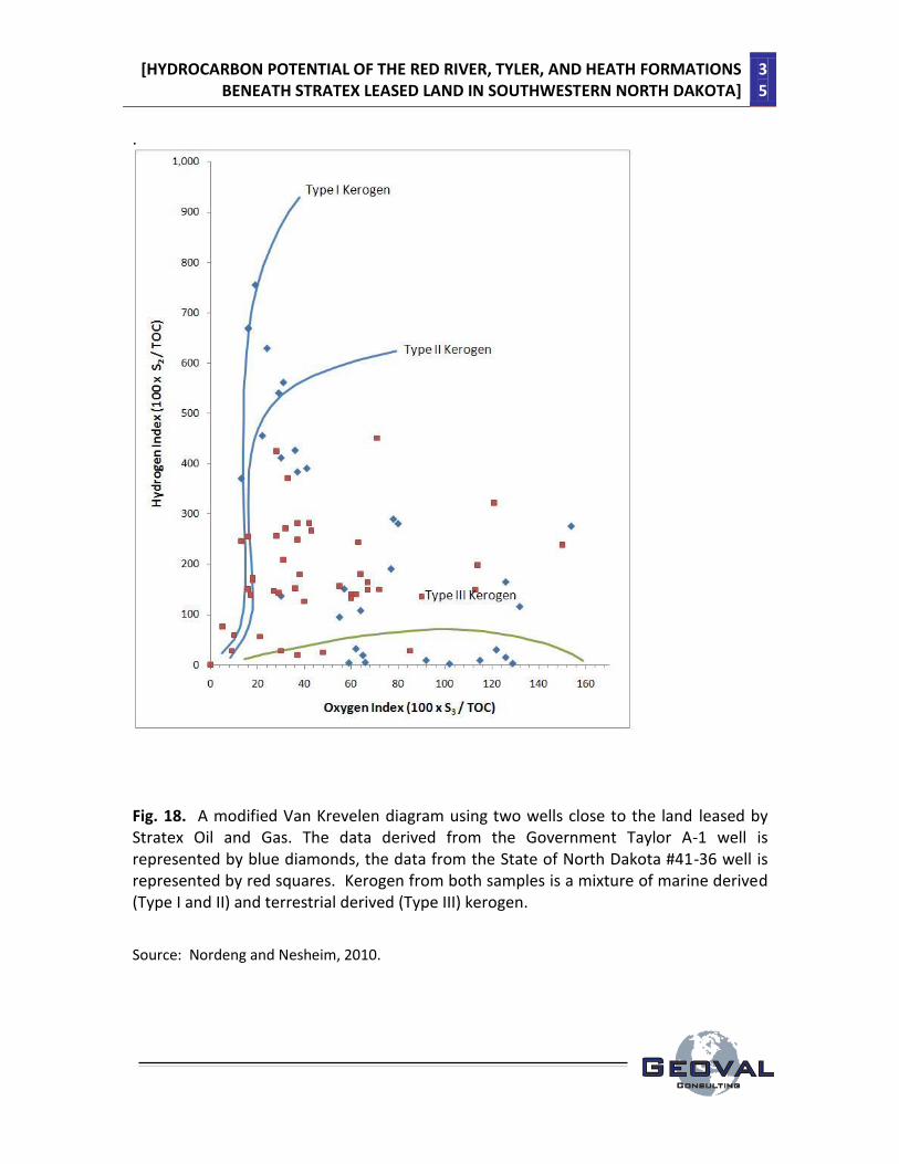
8. Tyler Formation as a Source Rock
Black and dark gray shales are shales that usually formed in anoxic
depositional environments. Anoxic depositional environments are crucial to the
preservation of the organic matter that will eventually become kerogen and
ultimately natural gas and oil in thermally mature formations. These black and dark
gray shales are the source rocks in the Tyler formation. A modified Van Krevelen
diagram is used to classify the kerogen in the source rock. Kerogen data from two
wells, close to the land leased by Stratex Oil and Gas, has been published (Fig. 18).
These two wells are the Government Taylor A-1 well (NDIC #4627) taken from the
Square Butte field in Golden Valley county and the State of North Dakota #41-36
well (NDIC #4789) taken from the Rocky Ridge field in Billings county. Kerogen from
both wells is a mixture of marine derived (Type I and II) and terrestrial derived (Type
III) kerogen. Type I and II kerogen is more likely to produce oil upon thermal
maturation, whereas Type III kerogen is more likely to produce natural gas upon
thermal maturation. The mixture of both marine and terrestrial derived kerogen in
these two wells is consistent with the fact that the depositional environment in
these two areas was a coastal to deltaic environment that was affected by a cyclic
change in sea level.
Good source rocks usually contain over 1.0% total organic carbon (TOC). TOC
values for the Tyler formation for the two wells mentioned above, the Government
Taylor A-1 well and the State of North Dakota #41-36 well, are as high as 10%. A
kerogen quality diagram constructed by plotting TOC against the mass of existing
hydrocarbons (S1) and the mass of potential hydrocarbons (S2) for these two wells
indicates that a significant amount of the kerogen from these two wells plot in the
good to excellent range (Fig. 19). The Tyler formation source rocks from the State of

[HYDROCARBON POTENTIAL OF THE RED RIVER, TYLER, AND HEATH FORMATIONS BENEATH STRATEX LEASED LAND IN SOUTHWESTERN NORTH DAKOTA]
34
North Dakota #41-36 well produced 257,158 barrels of oil and 5,506 mcf of natural
gas. This is a good confirmation of the validity of the modified Van Krevelen
diagram and the kerogen quality diagram for the Tyler formation in North Dakota,
discussed above.
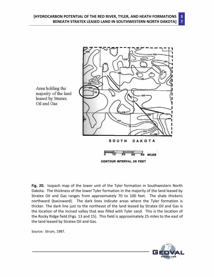
The lower Tyler formation ranges from 70 to 100 feet thick where Stratex Oil
and Gas has leased their land (Fig. 20). As discussed above, the lithology of the
lower unit of the Tyler formation is variable and contains silts, both red and black
shale, sandstone, limestone and coal.
[HYDROCARBON POTENTIAL OF THE RED RIVER, TYLER, AND HEATH FORMATIONS BENEATH STRATEX LEASED LAND IN SOUTHWESTERN NORTH DAKOTA]
35
.
Fig. 18. A modified Van Krevelen diagram using two wells close to the land leased by Stratex Oil and Gas. The data derived from the Government Taylor A-1 well is represented by blue diamonds, the data from the State of North Dakota #41-36 well is represented by red squares. Kerogen from both samples is a mixture of marine derived (Type I and II) and terrestrial derived (Type III) kerogen.
Source: Nordeng and Nesheim, 2010.

[HYDROCARBON POTENTIAL OF THE RED RIVER, TYLER, AND HEATH FORMATIONS BENEATH STRATEX LEASED LAND IN SOUTHWESTERN NORTH DAKOTA]
36
Fig. 19. A Tyler formation kerogen quality diagram constructed by plotting total organic carbon (TOC) against the mass of existing hydrocarbons in the sample (S1) and potential hydrocarbons in the sample (S2). The data from the samples from the Government Taylor A-1 well are represented by green circles; the data from the samples from the State of North Dakota #41-36 well are represented by red squares. Most of the kerogen from these two wells plot in the good to excellent range.
Source: Nordeng and Nesheim, 2010.
[HYDROCARBON POTENTIAL OF THE RED RIVER, TYLER, AND HEATH FORMATIONS BENEATH STRATEX LEASED LAND IN SOUTHWESTERN NORTH DAKOTA]
37
Fig. 20. Isopach map of the lower unit of the Tyler formation in Southwestern North Dakota. The thickness of the lower Tyler formation in the majority of the land leased by Stratex Oil and Gas ranges from approximately 70 to 100 feet. The shale thickens northward (basinward). The dark lines indicate areas where the Tyler formation is thicker. The dark line just to the northeast of the land leased by Stratex Oil and Gas is the location of the incised valley that was filled with Tyler sand. This is the location of the Rocky Ridge field (Figs. 13 and 15). This field is approximately 25 miles to the east of the land leased by Stratex Oil and Gas. Source: Strum, 1987.

[HYDROCARBON POTENTIAL OF THE RED RIVER, TYLER, AND HEATH FORMATIONS BENEATH STRATEX LEASED LAND IN SOUTHWESTERN NORTH DAKOTA]
38
Many of the well logs surrounding the land leased by Stratex Oil and Gas were
reviewed to determine if they contained organic rich black shales. A significant number
of the wells did (Table 4). Given the thickness of the lower Tyler formation in the area
leased by Stratex Oil and Gas, there is a very good possibility that there is a significant
amount of organic rich source rocks beneath their land.
Table 4. Wells containing dark gray to black shale (Tyler formation) near the land leased by Stratex Oil and Gas
Source: NDIC oil and gas division, 2011
9. Heath Formation as a Source Rock
The Heath formation in southwestern North Dakota lies directly below the Tyler
formation in many areas. The contact between the Heath formation and the overlying
Tyler formation is erosional. Therefore, the Heath formation may be missing in some
areas of southwestern North Dakota due to erosion. The Heath formation is described
as a predominantly light gray to brown to black limestone, often cryptocrystalline and
argillaceous, interbedded with dark gray to black shale. Many of the well logs
surrounding the land leased by Stratex Oil and Gas were reviewed to determine if they
contained the organic rich black limestone of the Heath formation. Several of these

[HYDROCARBON POTENTIAL OF THE RED RIVER, TYLER, AND HEATH FORMATIONS BENEATH STRATEX LEASED LAND IN SOUTHWESTERN NORTH DAKOTA]
39
wells did (Table 5).
Both Maughan (1984) and Kranzler (1966) have identified the dark gray to brown to
black limestone of the Heath formation as the source of the oil that is found in the
overlying sandstones within the Tyler formation in Montana. The Heath formation may
also be a hydrocarbon source rock for the Tyler formation sandstone in southwestern
North Dakota.
Table 5. Wells containing dark brown to dark gray to black limestone (Heath formation) near the land leased by Stratex Oil and Gas
Source: NDIC oil and gas division, 2011
10. Summary
The Tyler formation of North Dakota has produced over 83 million barrels of oil
(as of 2010). Most of this oil has been extracted from marine delta front and barrier
island sands in the upper Tyler formation and from infilling sand in incised valleys that
were created during low sea stands in the lower Tyler formation.
Although there is still a limited amount of published data concerning the Tyler
formation under the land leased by Stratex Oil and Gas, it appears that many of the
conditions needed for hydrocarbon production are in place. These include…
1) Suitably thick (up to 100 ft) potential source rocks, the Tyler formation black
shales and the Heath formation black limestones, beneath the leased land.

[HYDROCARBON POTENTIAL OF THE RED RIVER, TYLER, AND HEATH FORMATIONS BENEATH STRATEX LEASED LAND IN SOUTHWESTERN NORTH DAKOTA]
40
2) The presence of high quality Type I and Type II oil prone kerogen, as well as
the presence of Type III kerogen very close to the leased land.
3) Evidence that the Tyler formation beneath the leased land has been heated
up to the degree that hydrocarbon generation can occur. The Tyler formation in
southwestern North Dakota typically has produced oil with API values that average 34.6
(Nordeng, 2011) this is consistent with moderate levels of thermal maturity.
4) In addition to the presence of shale, anhydrite is also present in the Tyler
formation. Both anhydrite and shale can form effective cap rocks, which will prevent
the loss of hydrocarbons through vertical migration. The Tyler formation is known to be
self sourced, which is a good indication that the shales and anhydrites are effective
caprocks for this formation.
5) The Tyler formation has several different types of sand lenses. The most
probable type of sand lens that may be found beneath the leased land is an
aggradational sand that has infilled an incised stream. Seismic work can help to
determine if such an incised stream exists beneath the leased land.
6) Potentially productive zones of the Tyler formation beneath the land leased
by Stratex Oil and gas will be found at depths of approximately 7,500 to 7,800 feet.
7) In North Dakota, wells are drilled on spacing units of various sizes. A spacing
unit is the area within which all mineral owners share the revenues from a particular
well, from a particular producing interval (field and pool). Many vertical wells in North
Dakota were historically drilled on 40 acre spacing units. Horizontal wells are drilled on
larger spacing units, such as 640 and 1280 acre spacing units (640 acres per square
mile), since they drain larger areas of the reservoir. The North Dakota Industrial
Commission (NDIC) is the state authority that determines the spacing unit. If a
particular spacing unit is highly productive, several wells can be drilled on that spacing
unit, subject to the approval of the NDIC.

[HYDROCARBON POTENTIAL OF THE RED RIVER, TYLER, AND HEATH FORMATIONS BENEATH STRATEX LEASED LAND IN SOUTHWESTERN NORTH DAKOTA]
41
Stratex Oil and Gas has leased approximately 15 sections in township and range
136N 106W. Each of these sections is 640 acres (1 square mile). If the NDIC approves a
640 acre spacing for a horizontal well, then Stratex Oil and Gas will have 15 areas in that
township and range where they can drill wells. If a well comes on line and is very
productive, Stratex Oil and Gas may ask for approval from the NDIC to drill several more
wells in that 640 acre section.
Stratex Oil and Gas has 22,000 acres, this is equal to 34 separate 640 acre
spacing units.
Potential limitations to economic hydrocarbon production from the Tyler
formation beneath the leased land include…
1) The presence of more red shale than black shale beneath the leased land
indicating that the depositional environment was oxidizing rather than anoxic.
2) The lack of sand lenses beneath the leased land which would act as
reservoirs.
3) Poor porosity and permeability within any existing sandstone as a result of the
presence of authigenic clay.
4) The absence of the Heath formation, due to erosion, beneath the leased land.
Concerning potential limitation #1: During the preparation of this report, it was
found that multiple well logs recorded the presence of dark gray to black shales in the
Tyler formation adjacent to the leased land. This strongly suggests that organic black
shales are present beneath the leased land as well. Further work needs to be done to
better define the lateral extent and thickness of any black shales beneath the leased
land.
Concerning potential limitation #2: The leased land is south of the east-west
trending delta front and barrier island complex that contains the “Fryburg” pay sands. A
more probable type of sand lens would be similar to the “Fritz” pay sands that are found

[HYDROCARBON POTENTIAL OF THE RED RIVER, TYLER, AND HEATH FORMATIONS BENEATH STRATEX LEASED LAND IN SOUTHWESTERN NORTH DAKOTA]
42
in the infilled incised valley beneath the Rocky Ridge field at depths of approximately
7,800 feet. Seismic work is recommended as a means of determining if such incised
valleys are present beneath the leased land. As discussed above, the presence of a
northwest-southeast striking fault beneath the Williams Creek field (T137N R106W) may
indicate that an erosional valley may be present beneath the leased land. If sand lenses
are not present beneath the leased land, it may be possible to successfully produce
hydrocarbons from the Tyler formation shales using unconventional means (horizontal
drilling and fracing) which has been proven to be successful in the Bakken shales.
Concerning potential limitation 3: If low porosity and permeability sands are
present beneath the leased land, it may be possible to successfully produce
hydrocarbons from them using unconventional means (horizontal drilling and fracing).
In addition, low permeability zones may act to compartmentalize elongate sandstone
reservoirs. Horizontal drilling would also work to bypass any low permeability zones
acting as barriers between porous and productive reservoirs.
Concerning potential limitation 4: If the Heath Dark gray to black limestones are
absent beneath the leased land, there is still the possibility that sufficient quantities of
Tyler formation black shales are in place as a source rock.

[HYDROCARBON POTENTIAL OF THE RED RIVER, TYLER, AND HEATH FORMATIONS BENEATH STRATEX LEASED LAND IN SOUTHWESTERN NORTH DAKOTA]
43
11. References Clark, D.E. and Friedman, G.M., 2005, Fracture Development and Properties within the Beekmantown Group Carbonates of Eastern New York State. Northeastern Geology and Environmental Sciences, vol. 27., no. 3, pgs 197-228. Dow, W.G. 1974, Applications of Oil-Correlation and Source-Rock Data to Exploration in the Williston Basin. AAPG bulletin, vol. 58, no. 7, pgs. 1253-1262. Kranzler, I. 1966, Origin of Oil in Lower Member of Tyler Formation of Central Montana. AAPG bulletin, vol. 50, no. 10, pgs. 2245-2259. Longman, M. W., et al., 1983, Origin and Geometry of Red River Dolomite Reservoirs, Western Williston Basin. AAPG Bulletin, vol. 67, no. 5, pgs. 744-771. Longman, M. W., et al., 1992, Reservoir Performance in Ordovician Red River Formation, Horse Creek and South Creek Fields, Bowman County, North Dakota. AAPG Bulletin, vol. 76, no. 4, pgs. 449-467. Maughan, T.O., 1984, Paleogeographic Setting of Pennsylvanian Tyler Formation and Relationship to Underlying Mississippian Rocks in Montana and North Dakota. AAPG bulletin, vol. 68, no. 2, pgs. 178-1195. Montgomery, S.L., 1997, Ordovician Red River “B”: Horizontal Oil Play in the Southern Williston Basin. AAPG Bulletin, vol. 81, no. 4, pgs. 519-532. Nesheim, T.O. and Nordeng, S.H., 2010, North to South Cross Section of the Tyler Formation (Pennsylvanian) With Rock Eval Data, North Dakota. Geologic Investigation no. 132, North Dakota Geological Survey. North Dakota Industrial Commission Oil and Gas division, 2011. https://www.dmr.nd.gov/oilgas Sturm, S.D., 1987, Depositional History and Cyclity in the Tyler Formation (Pennsylvanian) Southwestern North Dakota, in Williston Basin: An Anatomy of a Cratonic Province.

[HYDROCARBON POTENTIAL OF THE RED RIVER, TYLER, AND HEATH FORMATIONS BENEATH STRATEX LEASED LAND IN SOUTHWESTERN NORTH DAKOTA]
44
________________________________________________________________________ Legal Disclaimer: This report was prepared, in part, using the results of research work
performed by other workers. As a result, any errors and or omissions in the work of
others can affect the accuracy of the information provided in this report. Therefore,
while every effort was made to provide accurate and current information, no
guarantees of completeness, or accuracy, expressed or implied, can be made at this
time.

[HYDROCARBON POTENTIAL OF THE RED RIVER, TYLER, AND HEATH FORMATIONS BENEATH STRATEX LEASED LAND IN SOUTHWESTERN NORTH DAKOTA]
45
12. Supplemental report to Stratex Oil and Gas concerning the Hydrocarbon Potential beneath Stratex leased land in Golden Valley County, North Dakota
In the initial report concerning the hydrocarbon potential of the Red River
formation beneath the land leased by Stratex Oil and Gas, I indicated that seismic work
(by others) showed that there were several faults that ran through the Williams Creek
field that have a high probability of being beneath Stratex leased land to the southeast
of the Williams Creek field (Figs. 1 and 2).
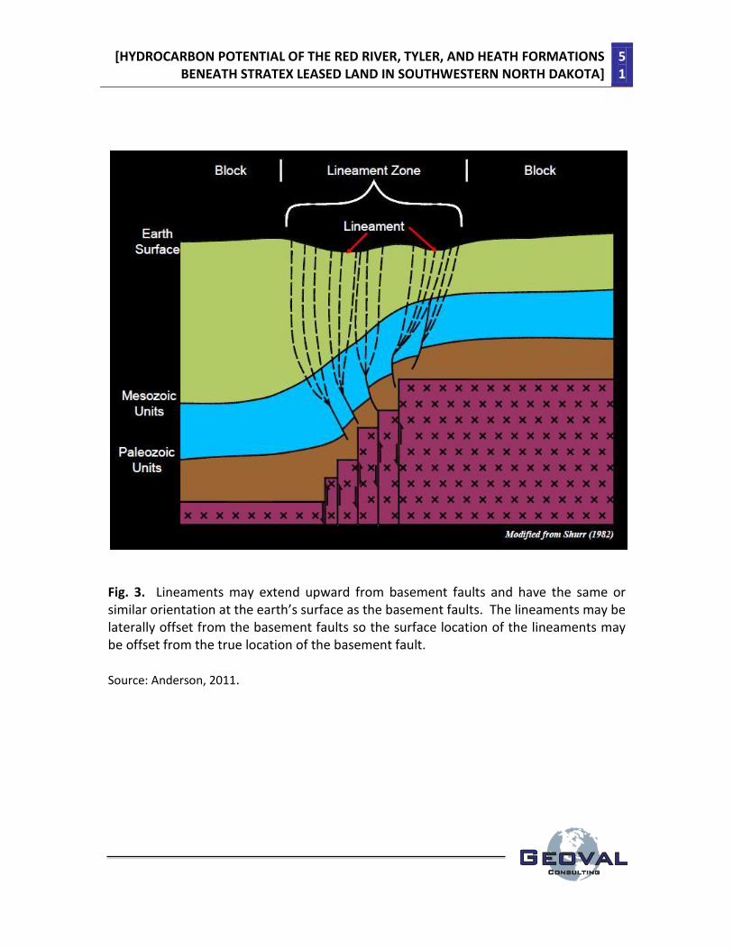
Lineaments on the Earth’s surface often form as a result of basement faulting
(Fig. 3). Lineaments often have the same, or similar orientation at the Earth’s surface as
the basement faults. These lineaments may be laterally offset from the basement
faults, so the surface location of the lineaments may be offset from the true location of
the basement fault. Lineament maps are constructed using satellite imagery, aerial
imagery, historical data or from elevation maps. Lineament maps constructed from
data taken from different sources often display different lineament features. This is
usually a function of the scale from which the data was collected, satellite imagery
versus aerial imagery, for example. Two such lineament maps are presented below (Figs.
4 and 5). What is immediately apparent is the fact that lineaments, present on both the
LANDSAT and shaded relief image lineament maps, are roughly parallel to the axis of the
fault that runs through the Williams Creek field (Figs. 1, 2, 4 and 5). This strongly
suggests that these faults extend southeastward, beneath the land leased by Stratex Oil
and Gas.
The Winnipeg shale (source rock) is vertically below the Red River formation and
migration of oil from the Winnipeg into the Red River is thought to have occurred
through fracture and fault zones. The faults and the fracture zones associated with
these faults act as pathways for the vertical migration of oil to the Williams Creek, Bull
Run and Cash fields.

[HYDROCARBON POTENTIAL OF THE RED RIVER, TYLER, AND HEATH FORMATIONS BENEATH STRATEX LEASED LAND IN SOUTHWESTERN NORTH DAKOTA]
46
Anderson (2011) indicated that productive wells in North Dakota were closer to
individual lineaments and to zones with high lineament density. The Cash field, to the
south of the land leased by Stratex Oil and Gas, is located in a high lineament density
zone that extends northward into the land leased by Stratex Oil and Gas (Fig. 6). This
high lineament density zone may be an attractive exploration target for Red River
horizontal drilling.
Concerning the Tyler formation in this area: Fault zones are zones of weakened
bedrock that often turn into stream and river beds as a result of the relative ease that
these zones can be eroded by flowing water. This fault zone has the potential for being
an incised valley (additional seismic work will confirm) that may be infilled with sands
and gravels as was found in the Rocky Ridge field to the east (Fig. 7). If an incised valley
is not present beneath the land leased by Stratex Oil and Gas, the zone of high
lineament density may be an attractive target for horizontal drilling and fracing in the
Tyler as is done in the Bakken shale (Fig. 6). The high lineament density may enhance
the permeability of the Tyler black shales and improve the productivity of any horizontal
wells drilled in the area.
13. Summary
1) Lineament maps, constructed from data obtained from both LANDSAT and shaded
relief imagery, strongly suggest that the faults that pass through the Williams Creek field
also pass through the land leased by Stratex Oil and Gas.
2) Fault and fracture zones act as conduits for hydrocarbon flow from the underlying
Winnipeg source rock into the Red River reservoir rock. Potential Red River targets
beneath the leased land are structural highs and horizontal drilling in porous zones (“B”
or “C” porous zones).

[HYDROCARBON POTENTIAL OF THE RED RIVER, TYLER, AND HEATH FORMATIONS BENEATH STRATEX LEASED LAND IN SOUTHWESTERN NORTH DAKOTA]
47
3) High lineament density zones have been shown to enhance the production of wells
throughout North Dakota. The presence of a high density lineament zone beneath the
land leased by Stratex Oil and Gas suggests that any productive well in this area may be
enhanced by the lineament as well.
4) The high number of parallel lineaments in this area may indicate that additional
faults, with the same orientation as the fault that runs through the Williams Creek field,
may be present beneath the land leased by Stratex Oil and Gas. Seismic work is needed
to confirm if this is true.
5) The fault zone that runs through the Stratex leased land may have become an incised
valley during the time that the Tyler formation was being deposited. If this is the case
(seismic work will be needed to determine if an incised valley exists in this area) then it
would be a good target for Tyler sand reservoirs.
6) The high lineament density zone that runs through the property leased by Stratex Oil
and Gas may be a good location for a horizontal drilling program for the Tyler formation
black shales.
[HYDROCARBON POTENTIAL OF THE RED RIVER, TYLER, AND HEATH FORMATIONS BENEATH STRATEX LEASED LAND IN SOUTHWESTERN NORTH DAKOTA]
48
14. References Anderson, F. (2011) Lineament mapping and analysis in the southern Williston Basin in southwestern North Dakota. NDGS geologic investigation #129. North Dakota Industrial Commission (NDIC) Oil and Gas division, 2011. https://www.dmr.nd.gov/oilgas Sturm, S.D., 1987, Depositional History and Cyclity in the Tyler Formation (Pennsylvanian) Southwestern North Dakota, in Williston Basin: An Anatomy of a Cratonic Province. ________________________________________________________________________ Legal Disclaimer: This report was prepared, in part, using the results of research work
performed by other workers. As a result, any errors and or omissions in the work of
others can affect the accuracy of the information provided in this report. Therefore,
while every effort was made to provide accurate and current information, no
guarantees of completeness, or accuracy, expressed or implied, can be made at this
time.

[HYDROCARBON POTENTIAL OF THE RED RIVER, TYLER, AND HEATH FORMATIONS BENEATH STRATEX LEASED LAND IN SOUTHWESTERN NORTH DAKOTA]
49
Fig. 1. The Williams Creek Oil field, located just to the north and west of the land leased by Stratex Oil and Gas. This is a structural contour map of the top of the Red River formation (in feet below sea level) indicating a structural high, in section 22, on an upthrown fault block (horst). Solid circle indicates producing wells. The Kremers 21-22 and Gearey #1 wells were productive from the Red River “B” porosity zone. Source: NDIC oil and gas division, 2011.

[HYDROCARBON POTENTIAL OF THE RED RIVER, TYLER, AND HEATH FORMATIONS BENEATH STRATEX LEASED LAND IN SOUTHWESTERN NORTH DAKOTA]
50
Fig. 2. The land leased by Stratex Oil and Gas is highlighted in yellow. If the fault in the Williams Creek field (Fig. 1) extends to the southeast, through the land leased by Stratex Oil and Gas, then this land may be similar to the land in Bowman County where horizontal wells through the “B” zone are productive. If a fault is present, horizontal drilling with a northeast azimuth will run through the fault and fracture zone, perpendicular to the fracture zone, increasing the amount of oil available to the wells.
Source: Modified from NDIC oil and gas division, 2011.
[HYDROCARBON POTENTIAL OF THE RED RIVER, TYLER, AND HEATH FORMATIONS BENEATH STRATEX LEASED LAND IN SOUTHWESTERN NORTH DAKOTA]
51
Fig. 3. Lineaments may extend upward from basement faults and have the same or similar orientation at the earth’s surface as the basement faults. The lineaments may be laterally offset from the basement faults so the surface location of the lineaments may be offset from the true location of the basement fault. Source: Anderson, 2011.

[HYDROCARBON POTENTIAL OF THE RED RIVER, TYLER, AND HEATH FORMATIONS BENEATH STRATEX LEASED LAND IN SOUTHWESTERN NORTH DAKOTA]
52
Fig. 4. Lineament map constructed from data obtained from LANDSAT-7 Enhanced Thematic Mapper. The lineaments highlighted in red have the same orientation as the faults that runs through the Williams Creek field and may have formed as a result of this faulting (Figs. 1 and 2). Source: Anderson, 2011.

[HYDROCARBON POTENTIAL OF THE RED RIVER, TYLER, AND HEATH FORMATIONS BENEATH STRATEX LEASED LAND IN SOUTHWESTERN NORTH DAKOTA]
53
Fig. 5. Lineaments mapped from USGS National Elevation Data (NED) shaded relief image sets with vertical exaggeration of 9X. The lineaments highlighted in red have the same orientation as the faults that runs through the Williams Creek field (Figs. 1 and 2). Their close proximity to the Williams Creek field strongly suggests that they were formed by the fault that runs through the field. Source: Anderson, 2011.

[HYDROCARBON POTENTIAL OF THE RED RIVER, TYLER, AND HEATH FORMATIONS BENEATH STRATEX LEASED LAND IN SOUTHWESTERN NORTH DAKOTA]
54
Fig. 6. Lineament density map for the land leased by Stratex Oil and Gas. The Cash field was productive from a zone with high lineament density that extends northward into Stratex land. Source: Anderson, 2011.
[HYDROCARBON POTENTIAL OF THE RED RIVER, TYLER, AND HEATH FORMATIONS BENEATH STRATEX LEASED LAND IN SOUTHWESTERN NORTH DAKOTA]
55
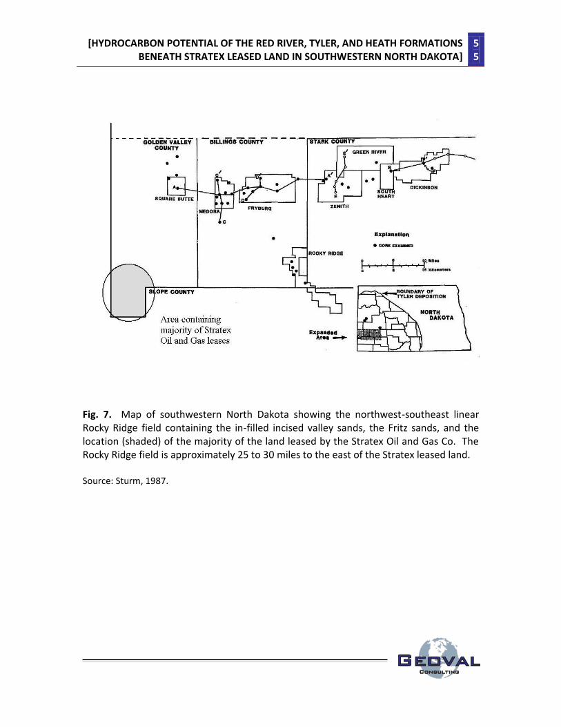
Fig. 7. Map of southwestern North Dakota showing the northwest-southeast linear Rocky Ridge field containing the in-filled incised valley sands, the Fritz sands, and the location (shaded) of the majority of the land leased by the Stratex Oil and Gas Co. The Rocky Ridge field is approximately 25 to 30 miles to the east of the Stratex leased land. Source: Sturm, 1987.