information collection and confirmation survey on digital
TRANSCRIPT

Information Collection and Confirmation Survey on Digital Transformation (DX)
Promotion in JICA ODA Projectsin the Republic of the Philippines
Japan International Cooperation Agency (JICA)
March 2021
Table of Contents
1. Background and Objectives of the Survey2. Political Framework of Digital
Transformation (DX) in the Construction Sector in the Philippines
3. Current Status and Challenges of Digital Transformation (DX) in JICAʼs ODA Projects in the Philippines
4. Applicable Digital Technologies for JICAʼs ODA Projects in the Philippines
5. Recommendations2

1. Background and Objectivesof the Survey
3
Background"Build, Build, Build" Under the slogan "Build, Build, Build", the
Republic of the Philippines (hereinafter referred to as "the Philippines") has continued to achieve annual economic growth of approximately 6%, with a focus on infrastructure investment to promote economic growth. However, COVID-19 is still spreading in the
Philippines and many of the ODA projects planned and being implemented by JICA have been delayed or suspended, requiring immediate action to be taken.
4

Objectives of the Survey
5
The Survey aims to promote Digital Transformation (DX) in JICA's ODA projects in the fields of civil engineering and construction in the Philippines by examining the possibilities of introducing applicable Digital Technologies.
6
Survey Target Projects
Project Year
Arterial Road Bypass Project(Ⅲ) 2018-2022
Davao City Bypass Construction Project 2015-2022
Dalton Pass East Alignment Alternative Road Project 2019-2020
Central Mindanao Road Project 2020-2021
Cebu-Mactan Bridge and Coastal Road Construction Project 2020-2029
Road Network Development Project in Conflict Affected Areas in Mindanao
2019-2021
Project Year
Metro Manila Subway Phase 1 (MMSP) 2018-2027
Technical Assistance Project to Establish of the Philippine Railway Institute (PRI)
2018-2023
North - South Commuter Railway Project (Clark–Malolos-Tutuban)(NSCR)
2015-2021
Capacity Enhancement of Mass Transit Systems in Metro Manila 2015-2022
Metro Rail Transit Line 3 Rehabilitation Project 2019-2022
DPWH DOTr

2. Political Frameworkof Digital Transformation (DX)in the Construction Sectorin the Philippines
7
PDTS 2022 summarizes the Philippine governmentʼs plan as it pursues its digital transformation goals. It builds on previous and existing plans, such as the Philippine Digital Strategy of 2011-2016, the Government Information Systems Plan, the Philippine Strategic ICT (Information and Communications Technology) Roadmap of 2006-2010, and the E-Government Master Plan of 2012 of the Department of Information and Communications Technology (DICT). Intentions of PDTS 2022:
• Develop user-generated content and encourage the use of open source technologies• Promote openness by providing online access to information and services• Encourage collaboration among stakeholders in developing DT-related content• Support the anti-corruption drive of the government and recognize the importance of data privacy and cybersecurity in creating a digital society
8
The Philippine Digital Transformation Strategy (PDTS) 2022:

E-Government Master Plan (EGMP) 2022:
In 17 June 2019, the Department of Information and Communications Technology (DICT), in fulfilling its mission to establish a one digitized government, launched the E-Government Master Plan (EGMP) 2022. EGMP 2022 is the successor of EGMP 2013-2016, which was also built upon previous ICT/digital plans, and is consistent with the strategy to continue to enhance the countryʼs e-government system as a vital tool for good governance under the Philippine Development Plan (PDP) 2022.EGMP 2022 is likewise aligned with the ASEAN ICT Masterplan (AIM) 2020 which envisions a digitally-enabled economy to enable an innovative, inclusive and integrated ASEAN Community.
9
Satellite Positioning System in the PhilippinesGeodetic system and satellite positioning in the Philippines
Adjusting to PRS92 According to "Executive Order No. 45, 1993", the geodetic reference system in
the Philippines is defined as "PRS92“, which is managed by the National Mapping and Resource Information Authority (NAMRIA). According to the 2011 Administrative Order No. 16, all investigations conducted by each ministry and agency should be coordinated with NAMRIA.
In June 2015, the 69th General Assembly of the United Nations resolved for member nations to shift to a global geodetic reference frame (Japan in 2000). NAMRIA drafted a revision of “Executive Order No. 45” and announced plans to install 163 CORS (Continuously Observation Reference Station) and move to world geodetic frame. As of April 2020, 54 points have been installed in the CORS network named PageNET (Philippines Active Geodetic Network).
Since the PRS92 is not a coordinate system based on a satellite positioning system, it is necessary to always correct the position, which can shift as much as 83mm/year, with measurement values using a global navigation satellite system (GNSS using WGS84 reference system) during construction work.
10
Fig. PageNet (NAMRIA Geoportal (2021.1))
Fig. Crustal Movement (NAMRIA (2016.10))

11
(1) BIM Mandate The DOTr mandated the use of Building Information Management (BIM) throughout the design,
construction and operational stages of rail sector projects to realize potential cost savings. The projects must achieve BIM Maturity Level 2 as defined in the ISO 19650 suite and supporting
standards. The purpose of the BIM Manual is to define the minimum information requirements for BIM to be
achieved by the lead contractors on the projects to achieve the DOTrʼs overall BIM objectives.
DOTrʼs BIM Manual The BIM Manual is a product of the ADB-funded Infrastructure Preparation and Innovation Facility (IPIF), Output 3 Sub-project: Digital Management Pilot Study for DOTrʼs Rail Sector.
Building Information Management (BIM) Framework in the Philippines:
12
Building Information Management (BIM) Framework in the Philippines:(2) BIM Objectives To establish a collaborative design and review process using a Common Data Environment (CDE) for all
design disciplines and the relevant stakeholders for use throughout the assets lifecycle. To standardize the production process and to ensure that all deliverables and information (2D, 3D CAD
models, BIM models and data schedules) are produced and issued in a uniform manner to the specified DOTr CAD Manuals, BIM standards and other specific requirements. To define the structure of proposed and potential data embedded within the digital BIM Models so that the
data is suitable for future as built records, operations and maintenance. To eliminate waste by creating virtual building processes and simulations from which the design,
construction, performance and operations can be visualized and simulated, resulting in: Potential cost savings by the elimination of rework, Improved coordination, Clash analysis and detection, and Long-term benefits for the post-construction operation and maintenance phase (which the contractor
must assist to establish and fully define). To provide open source as-built BIM Models which can be used by the DOTrʼs Operation andMaintenance Team.

13
ITEMS GENERAL CONSULTANTS (GC) LEAD CONTRACTORS
A) File/Document Naming StructureThe GC shall define the models and documents to be submitted for coordination and uploaded to the Common Data Environment following the file naming structure and numbering in accordance with the DOTr’s Document Management System Manual prior to the design phase.
B) CADThe GC shall define the 2D CAD drawings that shall be produced or based on the requirements of the DOTr’s CAD Manual prior tothe design phase.
C) 3D ModelsThe 3D BIM Models shall be produced to the requirements of DOTr’s BIM Manual or as defined by the GC in their BIM Execution Plan (BEP) prior to the design phase.
Ensure that the BIM models incorporate each element precisely in accordance with its quantity, size, shape, location and orientation.
Ensure that all disciplines and their supporting supply chain maintain their live models on the CDE for coordination at any
D) 3D BIM Model Level of Development (LOD)
Provisional LOD provided as a general rule for each design stage. To be provided by GC: Orange; by Contractor: Blue
The GC shall approve the BIM Execution Plan submitted by the Lead Contractor, which includes the table, prior to the commencement of any design authoring.
Provide a complete and exact level of development (LOD) in accordance with the requirements of AIA E203-2013, and BIM Forum LOD Specification Part I and Commentary for Building Information Models and Data (2019).
Describe the level of development (LOD) required for each and component, for each design stage, and designate the responsible for design authoring of models.
The table must be included in the BIM Execution Plan and submitted to the GC for approval prior to the commencement of any design authoring.
E) Clash DetectionClash analysis shall be carried out and reports prepared in a log to be maintained by the BIM Team during the project lifecycle.clash analysis reports shall be submitted to DOTr and GC to confirm the coordination between thevarious disciplines. The parameters and requirements for the clash analysis shall be agreed with DOTr and GC.
Level of Development (LOD)Engineer’s
Design ProjectDesign & Build
Project
100 (Concept) Inception Stage Inception Stage
200 (Approximate Geometry)
Technical DesignTechnical Design
300 / 350 (Precise Geometry) Construction
Design400(Fabrication and Assembly)
Construction Design
500 (As-built)
As-built As-built
Specific Information Production Methods and Procedures3) Project Information Management Process
14Source: BIM Forum LOD Specification Part I and Commentary for Building Information Models and Data (2019)
4) Level of Development (LOD)
Railroad Bridges Precast Structural I Girder (Concrete)

3. Current Status and Challengesof Digital Transformation (DX)in JICAʼs ODA Projectsin the Philippines
15
Current Statusof Digital Transformation (DX)in ODA projects
DPWH Projects
Project Year
Current status of JICAʼs ODA projects
Application of Digital Technologies
Availability of Public Network Services
BIM usageImpacts
from COVID-19
ProjectDelays Current Status Planned Internet Cell
Phone Electricity
Arterial Road Bypass Project(Ⅲ)
2018-2022 ✔ 10
months
• Online-meetings
• SNS• Wearable
Camera✔
Davao City Bypass Construction Project
2015-2022 ✔ • Online-
meetings ✔Dalton Pass East Alignment Alternative Road Project
2019-2020 ✔
More than 6months
• Online-meetings
• UAV LiDAR• BIM
• Tunnel boring system
• Inspection
Central Mindanao Road Project
2020-2021 ✔ • Online-
meetings• UAV LiDAR ✔ ✔
Cebu-Mactan Bridge and Coastal Road Construction Project
2020-2029 ✔ • Online-
meetings• UAV
LiDAR ✔ ✔ ✔Road Network Development Project in Conflict Affected Areas in Mindanao
2019-2021 ✔ 5
months• Online-
meetings• UAV LiDAR ✔
16

Current Statusof Digital Transformation (DX)in ODA projects
DOTr Projects
Project Year
Current status of JICAʼsODA projects
Application of Digital Technologies
Availability of Public Network Services
BIM usageImpacts
from COVID-19
ProjectDelays Current Status Planned Internet Cell
Phone Electricity
Metro Manila Subway Phase 1(MMSP)
2018-2027 ✔
More than 1
year
• Online-meetings
• GIS, BIM• CDE ※
(Bentley ProjectWise 365)
✔ ✔ ✔ ✔
Technical Assistance Project to Establish of the Philippine Railway Institute (PRI)
2018-2023 ✔
Cancelation of training in Japan
• Online-meetings
• XR• MMS ✔ ✔ ✔
North - South Commuter Railway Project (Clark-Malolos-Tutuban)(NSCR)
2015-2021 ✔
More than 3
months
• Online-meetings
• GIS, BIM• CDE ※
(Oracle Aconex)
• Video chat system ✔ ✔ ✔ ✔
Capacity Enhancement of Mass Transit Systems in Metro Manila
2015-2022 ✔
More than 6
months• Online-
meetings ✔ ✔ ✔Metro Rail Transit Line 3 Rehabilitation Project
2019-2022 ✔
More than 6
months• Online-
meetings ✔ ✔ ✔17※ CDE: Common Data Environment
Current Statusof Utilization of Digital Technologiesin JICAʼs ODA Projects
Utilization of digital technologies in JICAʼs ODA projects are currently limited.
18
Utilization of digital technologiesAll projects have been greatly affected by COVID-19, such as the inability of engineers to travel to the Philippines.Since face-to-face meetings and construction management are difficult, remote communication has been established utilizing communication tools such as Zoom, Microsoft Teams and Google Meet.Other than the online conferencing systems, the digital technologies used are limited to topographical surveys using UAV LiDAR (drone).
Current Statusof Public Network Serviceson Project Sites
19
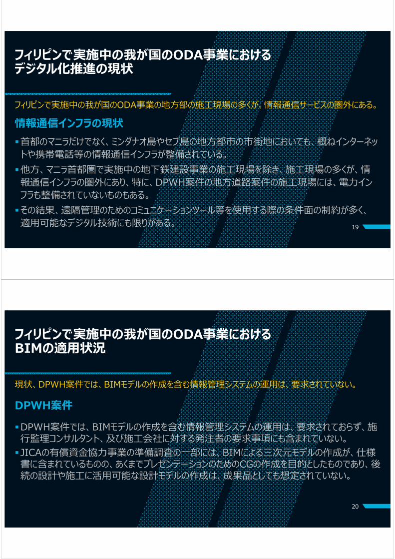
Project construction sites in rural area are not covered by service networks.InfrastructureRegarding information and communication infrastructure, urban areas are mostly covered by the Internet and cell phone services, even on the islands of Mindanao and Cebu.However, except for the railway project sites in the Manila metropolitan area, construction sites are not covered by the service areas, particularly the projects of DPWH in rural areas.Consequently, applicable remote communication technologies are limited.
BIM Usagein JICAʼs ODA ProjectsCreation of a BIM model as a project information management system is not required in the DPWH projects.
DPWH projectsCreation of BIM models as a project information management system is not required and is not actually applied by the general consultants (GCs) or contractors of the projects.Although JICA's preparatory surveys require the creation of BIM models as a presentation tool, it is not expected that the BIM models will be deliverables (submitted products) of the design and construction stages.
20

BIM Usagein JICAʼs ODA ProjectsCurrently, BIM is applied only to the construction stages of railway projects carried out by DOTr.
21
DOTr projectsDOTr issued a BIM Manual in 2019, which is in accordance with the international standard ISO19650, and this manual has been applied to two railway projects (MMSP and NSCR) .DOTr also established their Common Data Environment (CDE) to manage project information and to exchange digital data with general consultants (GCs) and contractors of the projects.Currently, the BIM Manual and the CDE have been partly utilized from the detailed design and construction stages.
Challengesof Digital Transformation (DX) in JICAʼs ODA Projectsin the PhilippinesToward the utilization of digital technologies with a view to applying BIM in the stages throughout the asset management lifecycle, including the operation and maintenance stage:Infrastructure and public servicesApplicable digital technologies are highly dependent on the availability of information and communication infrastructure and services.
22
BIMThe area of applicable digital technologies in the stages throughout the asset management lifecycle, including the operation and maintenance stage, mainly depends on the quality and quantity of information included in “as-built models” (asset information models) produced by BIM during the delivery phase.

4. Applicable Digital Technologies in JICAʼs ODA Projects in the Philippines
23
24
Map of Digital Technologies
Survey Design & Planning Construction Construction
management Inspection Operation & maintenance
UAV LiDAR, UAV Camera, 3D Laser Scanner
BIM LOD 100-200
ICT-Construction
XR, AR
Business Chat / SNS
Project stage
Level of DX
BIM LOD 300-350
BIM LOD 400-500
BIM
BIM 4D / 5D
Internet&Mobile
Network
UAV LiDAR, UAV Camera, 3D Laser Scanner
UAV LiDAR, UAV Camera, 3D Laser Scanner
VR
Online meeting
Digital technologies related to BIM model
Stand-alone type equipment

Digital Technologiesfor Surveying• SVY-UAV-01: UAV LiDAR• SVY-UAV-02: UAV Optical Camera• SVY-TER-01: 3D Laser Scanner
25
26
UAV LiDAR Code: SVY-UAV-01
General Description
UAV (Unmanned Aerial Vehicle) LIDAR (Light Detecting and Ranging) is a drone equipped with Laser Scanner and GNSS / IMU. We can also measure the riverbed by changing the wavelength of the laser to green. GNSS (Global Navigation Satellite System ) is corrected with GNSS ground reference data, and laser emission positions are accurately identified using 3-axis tilt data measured by IMU. The ground surface (DSM) is measured as point cloud by the reflected distance of the laser. We can generate digital elevation model (DEM) by extracting and modeling the points that passed through the leaves and trunks of the vegetation and reached the ground by filtering processing.
ApplicableConditions
To use the drone wirelessly, we need to apply to NTC. RPA pilot certificate from the Civil Aviation Authority of the Philippines (CAAP).
Cost Effectiveness
Capital Investment Cost (CAPEX) 50,000 USD
Operational Cost(OPEX) 10,000 USD/Year
Pasco (technical sheet)

27
UAV Optical CameraCode: SVY-UAV-02
General Description
Using a technology called SfM (Structure from Motion), you can create a 3D model from the pictures taken by the camera mounted on the UAV. Suitable for surveying during earthwork without vegetation. Accuracy depends on reference point, anti-aircraft sign installation, camera lens, altitude, etc. As similar as aerial photogrammetry with an aircraft, you can perform aerial triangulation and map from overlapping photographs. It can also be used for inspection of pavement and bridges.
ApplicableConditions
To use the drone wirelessly, we need to apply to NTC. RPA pilot certificate from the Civil Aviation Authority of the Philippines (CAAP).
Cost Effectiveness
Capital Investment Cost (CAPEX) 10,000 USD
Operational Cost(OPEX) 5,000 USD/Year
Topcon (brochure)
Kokusai Kogyo Co, Ltd. (brochure)
28
3D Laser Scanner Code: SVY-TER-01
Image
General Description
3D laser scanners on the ground can provide progress information on buildings and civil engineering works. Acquiring point cloud data improves reproducibility and accuracy, makes it easier to visually grasp the situation, and improves work efficiency. It is also used for inspection of completed works and collation with BIM data. There is also a mobile laser scanner that automatically tracks with TS (Total Station). It can contribute to the efficiency of pre-start surveying of pavement work.
ApplicableConditions
Useful for collation of BIM data.Equipment rental or purchase is required.
Cost Effectiveness
Capital Investment Cost (CAPEX) Depends on the situation
Operational Cost(OPEX) Depends on the situation Topcon and Nishio-rental (brochure)
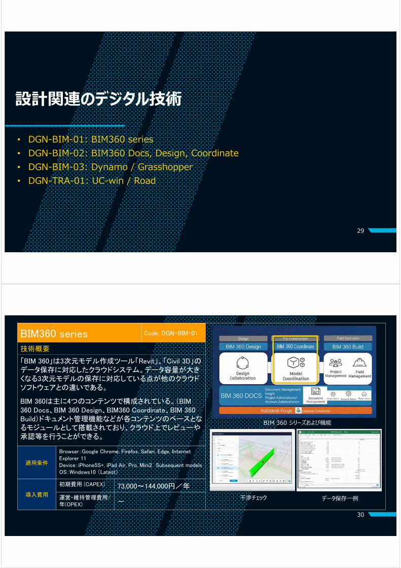
Digital Technologiesfor Design and Planning
• DGN-BIM-01: BIM360 series• DGN-BIM-02: BIM360 Docs, Design, Coordinate• DGN-BIM-03: Dynamo / Grasshopper• DGN-TRA-01: UC-win / Road
29
30
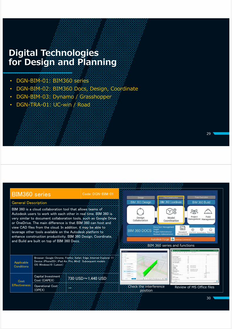
BIM360 series Code: DGN-BIM-01
General Description
BIM 360 is a cloud collaboration tool that allows teams of Autodesk users to work with each other in real time. BIM 360 is very similar to document collaboration tools, such as Google Drive or OneDrive. The main difference is that BIM 360 can host and view CAD files from the cloud. In addition, it may be able to leverage other tools available on the Autodesk platform to enhance construction productivity. BIM 360 Design, Coordinate, and Build are built on top of BIM 360 Docs.
ApplicableConditions
Browser:Google Chrome, Firefox, Safari, Edge, Internet Explorer 11Device:iPhone5S+, iPad Air, Pro, Mini2 Subsequent modelsOS:Windows10 (Latest)
Cost Effectiveness
Capital Investment Cost (CAPEX) 730 USD~1,440 USD
Operational Cost(OPEX) - Check the interference
position
BIM 360 series and functions
Review of MS Office files

31
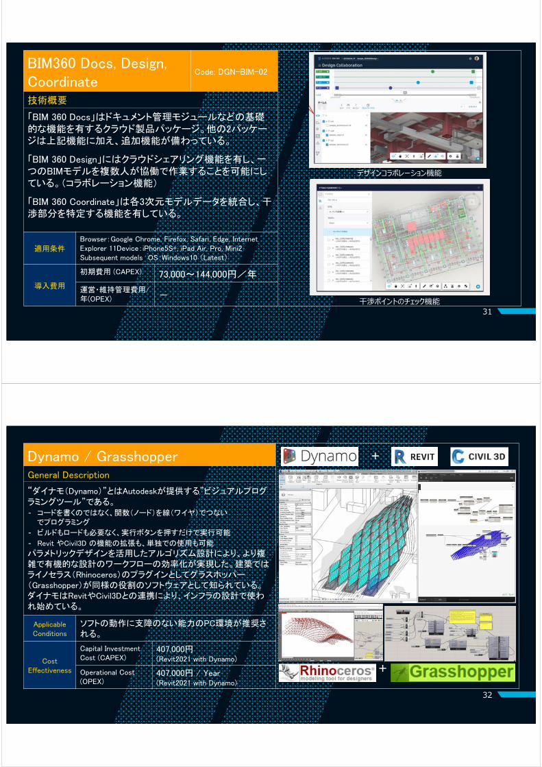
BIM360 Docs, Design, Coordinate
Code: DGN-BIM-02
General Description
BIM 360 Docs is a cloud-based document management solution that provides teams with the ability to publish, manage, review and approve project information in a common data platform with unlimited storage. BIM 360 Design provides features such as change tracking, version history, and monitoring tools for ensuring that new changes have been viewed by project teams. Its objective is to enable work-sharing in real time. BIM 360 Coordinate allows users to merge local project files to the master model in the cloud and manage clashes in the process. BIM 360 build hasn’t been released in Japan.
ApplicableConditions
Browser:Google Chrome, Firefox, Safari, Edge, Internet Explorer 11Device:iPhone5S+, iPad Air, Pro, Mini2 Subsequent modelsOS:Windows10 (Latest)
Cost Effectiveness
Capital Investment Cost (CAPEX) 730 USD~1,440 USD
Operational Cost(OPEX) -
Check the crash position from BIM 360 Coordinate
Design collaboration from BIM 360 Design
32
Dynamo / Grasshopper Code: DGN-BIM-03
Image
General Description
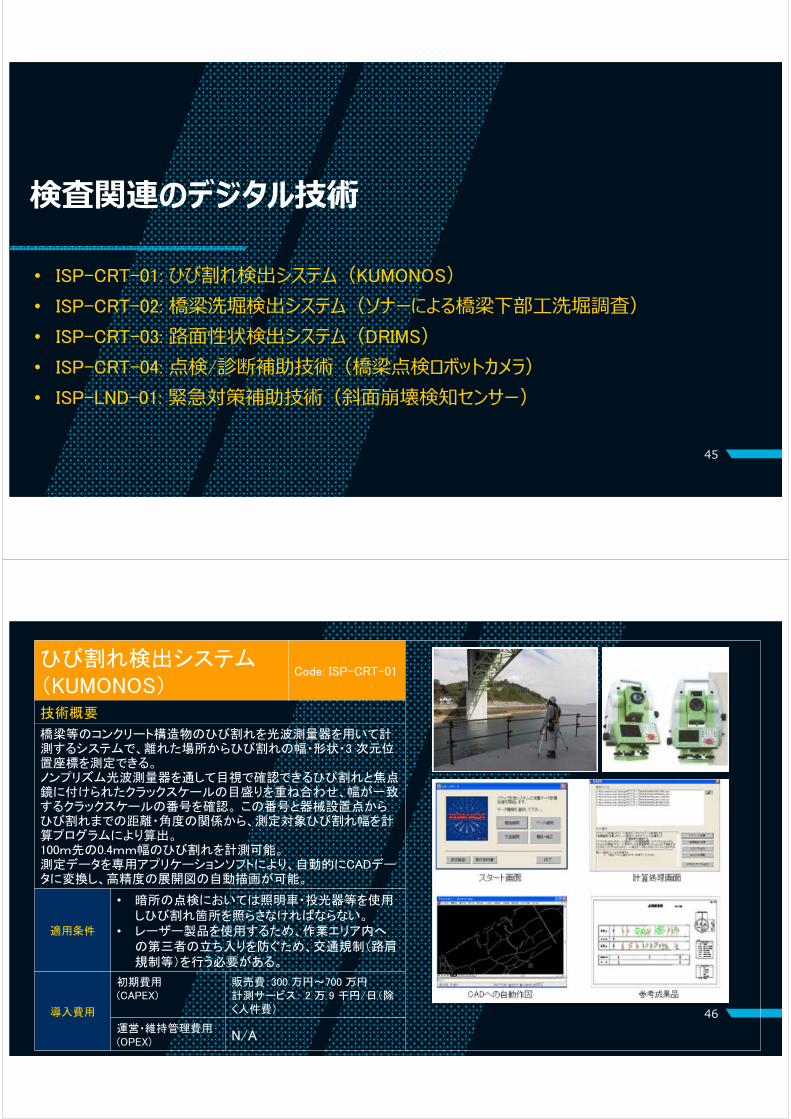
Dynamo is a visual programming tool for automating design tasks provided by Autodesk.
• Rather than writing code, programming is done by connecting functions (nodes) with wires.
• No need to build or load, just press the run button.
• Use alone or extend Revit and Civil 3D functionality.
Algorithm design utilizing parametric design has made it possible to make more complicated and organic designs and streamline workflows. In architectural design, Grasshopper is a plug-in for Rhinoceros software that has similar functions to Dynamo.
ApplicableConditions
PC capability that does not interfere with the operation of each software is recommended.
Cost Effectiveness
Capital Investment Cost (CAPEX)
3,900 USD(Revit2021 with Dynamo)
Operational Cost(OPEX)
3,900 USD/Year(Revit2021 with Dynamo)
+
+

33
UC-win / Road Code: DGN-TRA-01
Image
General Description
Forum8 software company has been developing solutions for information modeling (IM) and virtual reality (VR) for 20 years. This software can combine the creation of an integrated model with a VR platform. By using a drive simulator that makes use of a precise 3D model, it is possible to perform various road design evaluations such as collection of viewpoint measurement logs with high accuracy. It can also be linked with Civil 3D, and various in-house plug-ins allow you to perform various abundant simulations in a highly compatible environment. It can also be customized.
ApplicableConditions
PC capability that does not interfere with the operation of each software is recommended.
Cost Effectiveness
Capital Investment Cost (CAPEX) 18,300 USD (Ultimate Ver.)
Operational Cost(OPEX) 7,300 USD/Year (Ultimate Ver.)
Digital Technologiesfor Construction• CON-BIM-01: Navisworks Manage• CON-BIM-02: Navis+• CON-TBM-01: C-Shield• CON-TBM-02: ARiGATAYA• CON-TBM-03: Segment tracing system• CON-ICN-01: MG (Machine Guidance)• CON-ICN-02: MC (Machine Control)
34

35
NavisWorks Manage Code: CON-BIM-01
General Description
NavisWorks is a design review product from Autodesk to improve BIM coordination. It allows users to combine 3D models and navigate around them in real-time and review the model using a set of tools including comments, viewpoint and measurements. In attached function, users can carry out interference (clash) detection, 4D time simulation so that field workers can easily understand construction process and they can reduce expensive delays and rework.
ApplicableConditions
CPU:Intel® Pentium® 4 or AMD Athlon™ 3.0 GHz or more overMEMORY:RMA 2GBHDD:15GB or more overOS:Windows(latest ver. 64bit)
Cost Effectiveness
Capital Investment Cost (CAPEX) 1,500 USD
Operational Cost(OPEX) -
Interference detection by Navisworks
4D time simulation by Navisworks
36
Navis+ Code: CON-BIM-02
General Description
Navis+ is an attribute management software which combines with NavisWorks from Autodesk. This software can manage attribute information, such as segment information, measurement information, construction date and time for 3D models. Users can prepare attribute information using in a spreadsheet, which users are familiar with. In addition, Timeliner, which contains Navis+, has a function of construction process control and cost information management, such as material cost and labour costs, so that 5Dplanning can be achieved.
ApplicableConditions
CPU:Inter® Pentium® 4 or AMD Athlon™ 3.0GHz more over Memory:8GB HDD:15GB more overOS:64bit Japanese ver. Windows10 Windows8.1 Windows7 Software:Autodesk Navisworks Manage or Simulate Adobe® Acrobat® Reader DC
Cost Effectiveness
Capital Investment Cost (CAPEX) 1,500 USD
Operational Cost(OPEX) -
Concept of Navis+
Cost attribute function (5D)
User can integrate the cost attributeFor exampleMaterial cost, Total cost
3D model, including the attribute info
Making attribute info with
Excel
Building 3D model with
3DCAD
Navisworks
Navis+

37
C-Shield Code: CON-TBM-01
General Description
C-Shield is a BIM solution software for Shield tunneling project. This solution must be combined with NavisWorks. This software automatically builds 3D model of shield tunnel and shield machine position during the construction process with low requirements for user skill levels. Based on the positioning information from the shield machine, this software can visualize the machine’s model and assembled segments with accurate positioning in a 3D model. Plus, combining with topographical and existing structural information, experts can grasp overburden conditions and positioning between the structure and the machine.
ApplicableConditions
CPU:Inter® Pentium® 4 or AMD Athlon™ 3.0GHz more over Memory:8GB HDD:15GB more overOS:64bit Japanese ver. Windows10 Windows8.1 Windows7 Software:Autodesk Navisworks Manage or Simulate Adobe® Acrobat® Reader DC
Cost Effectiveness
Capital Investment Cost (CAPEX) 1,000 USD~
Operational Cost(OPEX) -
Automatically builds 3D model
Combine with topographical and structural information Progress of shield machine
38
ARiGATAYA Code: CON-TBM-02
General Description
ARiGATAYA is a shield machine monitoring system that collects and manages surveying and measurement data from excavation work and shield tunneling method. This system estimates the condition of the ground, excavated soil and the load conditions of the shield machine through statistical processing of construction measurement data. Additionally, the system calculates the position of machines and segments to obtain the deviation from the baseline. This system can facilitate safe construction and reduce workload to improve construction efficiency.
ApplicableConditions
This system is a lease product and PC with Display Monitor include this package. The user doesn’t need to prepare PC and around tools.
Cost Effectiveness
Capital Investment Cost (CAPEX) 120,000 USD
Operational Cost(OPEX) -
Result of analysis in the systemProgress of shield machine
Planning machine progress and segment assembly
Planning of machine progress
Planning of segment assembling
39
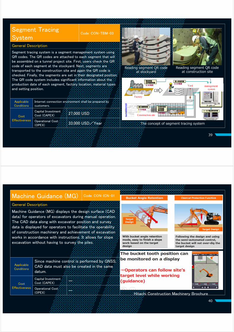
Segment Tracing System
Code: CON-TBM-03
General Description
Segment tracing system is a segment management system using QR codes. The QR codes are attached to each segment that will be assembled on a tunnel project site. First, users check the QR code of each segment at the stockyard. Next, segments are transported to the construction site and again the QR code is checked. Finally, the segments are set in their designated position. The QR code system includes significant information about the production date of each segment, factory location, material types and setting position.
ApplicableConditions
Internet connection environment shall be prepared by customers.
Cost Effectiveness
Capital Investment Cost (CAPEX) 27,000 USD
Operational Cost(OPEX) 33,000 USD/Year
Reading segment QR code at construction site
The concept of segment tracing system
Reading segment QR code at stockyard
Factory
Yard managementsystem
Construction site
40
Machine Guidance (MG) Code: CON-ICN-01
General Description
Machine Guidance (MG) displays the design surface (CAD data) for operators of excavators during manual operation. The CAD data along with excavator position and survey data is displayed for operators to facilitate the operability of construction machinery and achievement of excavation works in accordance with instructions. It allows for slopeexcavation without having to survey the piles.
ApplicableConditions
Since machine control is performed by GNSS, CAD data must also be created in the same datum.
Cost Effectiveness
Capital Investment Cost (CAPEX) ー
Operational Cost(OPEX) ー
Hitachi Construction Machinery Brochure

41
Machine Control (MC) Code: CON-ICN-02
General Description
Machine Control (MC) automatically controls construction equipment to achieve the target design surface in accordance with CAD data. It is a type of autonomous operation technology. It can be applied to a variety of construction equipment, including bulldozers, motor graders, compactors and backhoes. The equipment are controlled using 3D position information from GNSS and 3-axis orientation information from the on-board IMU. There is also a control system that can be retrofitted to equipment already in use.
ApplicableConditions
Since machine control is performed by GNSS, CAD data must also be created in the same datum.
Cost Effectiveness
Capital Investment Cost (CAPEX) ー
Operational Cost(OPEX) ー
Komatsu (Brochure)
Digital Technologiesfor Construction Management
• SPV-RMS-01: Digital Progress Monitoring• SPV-XRS-01: VR/AR (with AR marker)
42

43
Digital Progress Monitoring
Image
General Description
It can streamline a process from reporting at site throughmonitoring at office.
Progress and test results can be reported at site usingvarious mobile devices.
Reported information can be shared with engineersworking at office.
Documents/Drawings stored in the server can be sharewith people smoothly.
ApplicableConditions
Internet connection is required. (Mobile-app can
be activated without internet connection. After site work, data can be sent through internet.)
Cost Effectiveness
Capital Investment Cost (CAPEX) 500 USD
Operational Cost(OPEX)
5,000 USD/ 5 user /Year22,000 USD/50 user /Year
Changing your handwriting reports directly into tablet
Your accustomed Excel forms can be changed directly into an electronic form for an iPad or a Windows tablet without losing any convenience of handwriting paper reports.
44
VR/AR (with AR marker)Code: SPV-XRS-01
Image
General Description
Virtual Reality (VR): Simulation of immersion in a virtual space.Augmented Reality (AR): Merged view of a real-world environment enhanced by a virtual model.
It is used for consensus building by sharing the completed image with clients, promoting understanding among design personnel and construction personnel, and improving the efficiency of meetings. It is also possible to give position information to a 3D model with an AR marker and visualise it in real space.
ApplicableConditions
Contents: Creation of 3D model data with modeling software / 3D model display application and data storage linked with the device .Device: VR headset, PC, Tablet etc.
Cost Effectiveness
Capital Investment Cost (CAPEX)
8,200 USD (Hololens2 + Revit + Unity Reflect)
Operational Cost(OPEX)
4,700 USD/Year (Revit + Unity Reflect)
AR marker
Digital Technologiesfor Inspection• ISP-CRT-01: Crack detection
• ISP-CRT-02: Bridge substructure washing moat survey by sonar
• ISP-CRT-03: Dynamic Response Intelligent Monitoring System(DRIMS)• ISP-CRT-04: Monitoring system using equipment such as bridge inspection robot
cameras
• ISP-LND-01: Slope collapse detection sensor
45
46
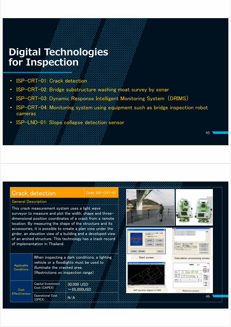
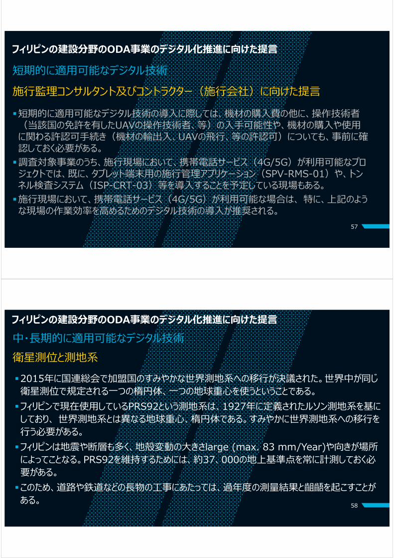
Crack detection Code: ISP-CRT-01
Image
General Description
This crack measurement system uses a light wave surveyor to measure and plot the width, shape and three-dimensional position coordinates of a crack from a remote location. By measuring the shape of the structure and its accessories, it is possible to create a plan view under the girder, an elevation view of a building and a developed view of an arched structure. This technology has a track record of implementation in Thailand.
ApplicableConditions
When inspecting a dark conditions, a lighting vehicle or a floodlights must be used to illuminate the cracked area. (Restrictions on inspection range)
Cost Effectiveness
Capital Investment Cost (CAPEX)
30,000 USD~65,000USD
Operational Cost(OPEX) N/A
Start screen Calculation processing screen
Self-operation diagram to CAD Reference product

47
Bridge substructure scouring survey by sonar
Code: ISP-CRT-02
General Description
This technology uses sonar with ultrasonic waves to produce color imaging of underwater conditions. The shape of the riverbed and pier base can be displayed in in real time. The condition of scouring of bridge substructures, such as piers underwater, can be investigated from above the bridge without conducting shallow surveys or diving surveys.
ApplicableConditions
• The water depth at the survey site must be 1 m or more
• Since the rod that supports the sonar is attached to the balustrade of the bridge, there are restrictions on the site conditions such as the height difference to the water surface and the viewing width.
Cost Effectiveness
Capital Investment Cost (CAPEX) 48,000 USD
Operational Cost(OPEX) N/A
flow
flow
sonar
Pier
longitudinal direction
transversal direction
Sonar position Water surface
pier
scouring
Riverbed
48
Dynamic Response Intelligent Monitoring System(DRIMS)
Code: ISP-CRT-03
General Description
DRIMS uses vertical acceleration to measure the dynamic response of a typical vehicle from sensors (accelerometer, gyro sensor and GPS receiver) built into an equipped smartphone while traveling at a constant speed. The technology evaluates the road surface according to the International Roughness Index (IRI). It has been implemented in multiple countries, including Kenya and Cambodia.
ApplicableConditions
• Not applicable to sidewalks where vehicles cannot pass.
• Limited to places where a rover (vehicle width 2.2m) can travel.
• Working time is limited to daytime.
Cost Effectiveness
Capital Investment Cost (CAPEX) 4,800USD/set (Excluding PC)
Operational Cost(OPEX) -
Smartphone version DRIMS

49
Monitoring system using equipment such as bridge inspection robot cameras
Code: ISP-CRT-04
Image
General Description
This periodic monitoring system acquires secular change data for parts such as bearings and girder ends of concrete bridges that are difficult to access and inspect visually. It is possible to ensure continuity of equipment installation locations by monitoring using a bridge inspection robot camera, digital camera and laser scanner with connected GNSS equipment, which was previously difficult with conventional periodic monitoring. This technology has a track record of implementation in Bangladesh.
ApplicableConditions
Use only in a work environment where a workspace can be secured and where there is not interference for image capture.
Cost Effectiveness
Capital Investment Cost (CAPEX)
30,000 USD~95,000 USD
Operational Cost(OPEX) N/A
Suspended type High altitude type
Operation terminal (tablet)
Robot camera
Cooperation with Web system
Monitoring status of girder end using robot camera (high altitude type)
Monitoring record data Creating a database of survey results
50
Slope collapse detection sensor Code: ISP-LND-01
General Description
A sensor module is embedded at a position about 10 cm underground, and a wireless communication device is installed above ground. Since the ground surface tilts during ground movements, the tilt angle is measured over time (standard 10-minute intervals). The data is sent to the server via the FOMA line. It is a compact, lightweight, power-saving and low-priced tilt sensor that can be installed anywhere.
ApplicableConditions
Sensor maintenance is required.
Cost Effectiveness
Capital Investment Cost (CAPEX)
Slope collapse detection sensor: 810 USD/sensor
Operational Cost(OPEX) N/A
Image of measuring equipment installation
Wireless communication device
cable length
Sensor module Soil
moisture meter
Slope transversal inclination
Slope direction inclination
Suppression embankment construction
Cut excavation
Abnormality detection
Emergency inspection
Deformation speed anomaly detection data
Inclin
atio
n a
ngl
e
Digital Technologiesfor Operation & Maintenance
• OPE-XRS-01: VR Safety Training
51
52
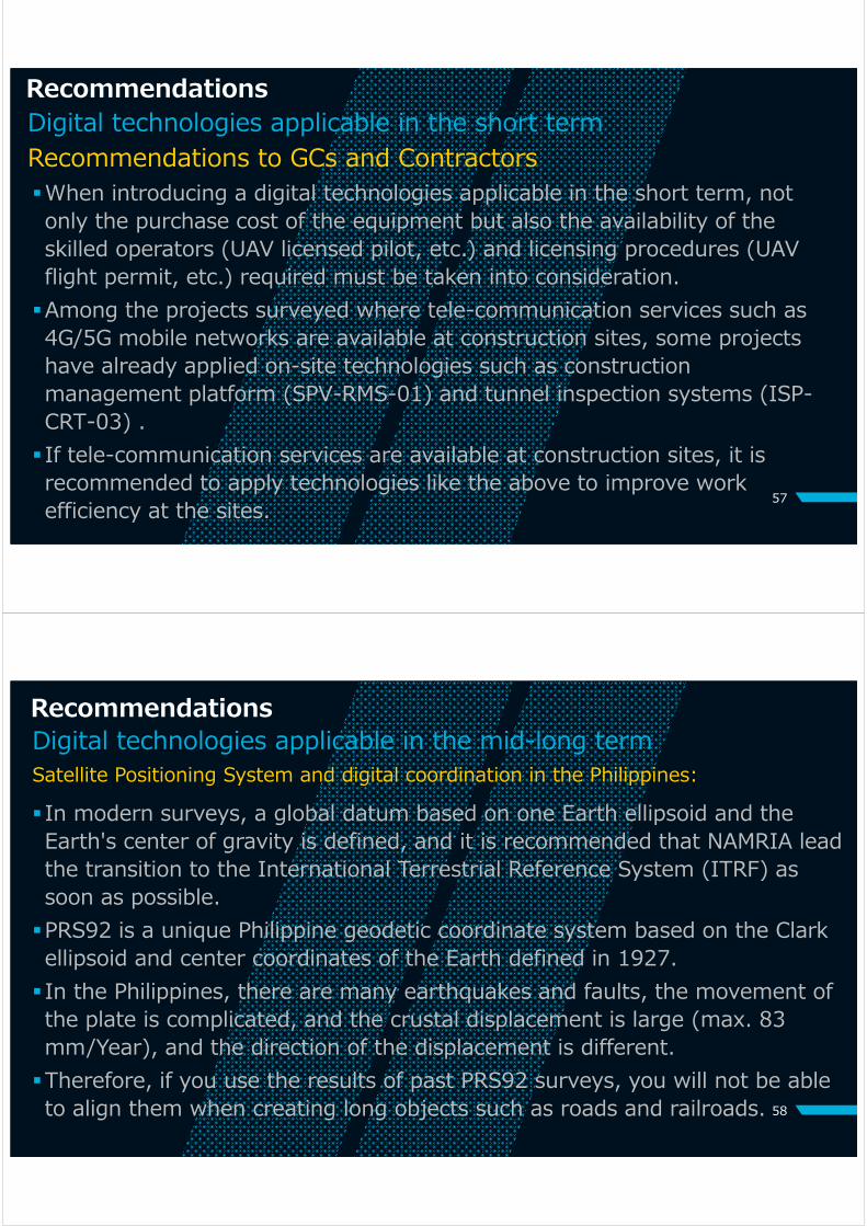
VR Safety Training Code: OPE-XRS-01
General Description
Virtual reality (VR) technology provides effective andflexible safety training.
• Critical situation like falling can be experienced.
• Training can be conducted anytime and anywhere, evenif target assets are still under operational.
• Training can be easily repeated without time-consumingpreparation.
ApplicableConditions
Standalone type: NO condition
Subscription type: Broadband is required.
Cost Effectiveness
Capital Investment Cost (CAPEX)
Standalone type:400~700k USD + VR gear
Operational Cost(OPEX)
Subscription type:800k USD / Year
VR Safety Training at Construction Site
VR Safety Training at Railway Depot

5. Recommendations
53
54
List of Applicable Digital technologiesProject Project
stage
Surveying ※ Design & Planning Construction Construction Management Inspection O&M
UAVLiDAR
UAVCamera
3DScanner
BIM360
Dynamo Grass
hopperUC-win /
Road Navisworks Navis+ C-ShieldARiGATAY
A
Segment tracing system
MG MCDigital
Progress Monitoring
VR/AR Crack
detection Bridge survey sonar
DRIMSbridge
inspection robot
cameras
Slope collapse detection sensor
VR Safety Training
Arterial Road Bypass Project(Ⅲ) Construction ◎ ◎ ◎ ○ ○ ○ ○ ○ ◎ ◎ ◎ ◎ ◎ ◎ ○Davao City Bypass Construction Project Construction ◎ ◎ ◎ ○ ○ ○ ○ ○ ◎ ◎ ◎ ◎ ◎ ◎ ○Dalton Pass East Alignment Alternative Road Project
Outline Design(Basic
Design)
◎ ◎ ◎ ○ ○ ○ ○ ○ ◎ ◎ ◎ ◎ ◎ ◎ ○Central Mindanao Road Project
Detailed Design ◎ ◎ ◎ ○ ○ ○ ○ ○ ◎ ◎ ◎ ◎ ◎ ◎ ○
Cebu-Mactan Bridge and Coastal Road Construction Project
Detailed Design ◎ ◎ ◎ ○ ○ ○ ○ ○ ◎ ◎ ◎ ◎ ◎ ◎ ○
Road Network Development Project in Conflict Affected Areas in Mindanao
Detailed Design ◎ ◎ ◎ ○ ○ ○ ○ ○ ◎ ◎ ◎ ◎ ◎ ◎ ○
DPWH projects
◎ Applicable in the short term○ Applicable in the mid-long term
※ Surveying: These technologies can be applied to topographic survey, inspection and monitoring from survey stage to O&M stage.

55
List of Applicable Digital technologies DOTr projects
Project Project stage
Surveying ※ Design & Planning Construction Construction Management Inspection O&M
UAVLiDAR
UAVCamera
3DScanner
BIM360
Dynamo Grass
hopperUC-win /
Road Navisworks Navis+ C-ShieldARiGATAY
A
Segment tracing system
MG MCDigital
Progress Monitoring
VR/AR Crack
detection Bridge survey sonar
DRIMSbridge
inspection robot
cameras
Slope collapse detection sensor
VR Safety Training
Metro Manila Subway Phase 1 (MMSP) Construction ◎ ◎ ◎ ◎ ◎ ◎ ◎ ◎ ◎ ◎ ○ ○ ◎ ○ ◎ ◎ ◎ ◎ ◎ ○Technical Assistance Project to Establish of the Philippine Railway Institute (PRI)
Training course
on-going◎ ◎
North - South Commuter Railway Project (Clark-Malolos-Tutuban)(NSCR)
Construction ◎ ◎ ◎ ◎ ◎ ◎ ◎ ○ ○ ◎ ○ ◎ ◎ ◎ ◎ ◎ ○Capacity Enhancement of Mass Transit Systems in Metro Manila
Construction ◎ ◎ ◎ ○ ○ ○ ○ ○ ○ ◎ ◎ ◎ ◎ ◎ ◎ ○
Metro Rail Transit Line 3 Rehabilitation Project Construction ◎ ○
◎ Applicable in the short term○ Applicable in the mid-long term
※ Surveying: These technologies can be applied to topographic survey, inspection and monitoring from survey stage to O&M stage.
56
RecommendationsDigital technologies applicable in the short term
In the short term, especially in situations where COVID-19 infection is widely spreading, it is recommended to introduce stand-alone surveying equipment (UAV, etc.) and inspection equipment (inspection robot, remote sensing, etc.) that can reduce on-site works and improve personnel efficiency without the need for additional infrastructure or BIM design data and information.When introducing additional equipment and software that requires a certain amount of additional costs, such as tunnel inspection systems (ISP-CRT-03) and VR training system (OPE-XRS-01), it is also recommended to modify the project components and to consider the necessary costs as a part of the project cost.
Recommendations to the Executing Agencies (DPWH and DOTr)
57
RecommendationsDigital technologies applicable in the short term
When introducing a digital technologies applicable in the short term, not only the purchase cost of the equipment but also the availability of the skilled operators (UAV licensed pilot, etc.) and licensing procedures (UAV flight permit, etc.) required must be taken into consideration.Among the projects surveyed where tele-communication services such as 4G/5G mobile networks are available at construction sites, some projects have already applied on-site technologies such as construction management platform (SPV-RMS-01) and tunnel inspection systems (ISP-CRT-03) . If tele-communication services are available at construction sites, it is recommended to apply technologies like the above to improve work efficiency at the sites.
Recommendations to GCs and Contractors
58
Recommendations
In modern surveys, a global datum based on one Earth ellipsoid and the Earth's center of gravity is defined, and it is recommended that NAMRIA lead the transition to the International Terrestrial Reference System (ITRF) as soon as possible.PRS92 is a unique Philippine geodetic coordinate system based on the Clark ellipsoid and center coordinates of the Earth defined in 1927. In the Philippines, there are many earthquakes and faults, the movement of the plate is complicated, and the crustal displacement is large (max. 83 mm/Year), and the direction of the displacement is different.Therefore, if you use the results of past PRS92 surveys, you will not be able to align them when creating long objects such as roads and railroads.
Satellite Positioning System and digital coordination in the Philippines:Digital technologies applicable in the mid-long term
59
Recommendations
GNSS is also used for general surveying, drone, aircraft, automobile, and general mobile phone to acquire location information. There is a big difference between the GNSS coordinate system and PRS92, the conversion is complicate (the conversion parameters vary from place to place) and can be misleading.For DPWH and DOTr, it is recommended to set the survey specification to WGS84, which is the reference coordinate for satellite positioning, convert it to PRS92, and finally have two survey results. If the Philippines has defined a new geodetic system that complies with the International Terrestrial Reference System (ITRF), the transition from WGS84 is almost the same and easy. Also, if the construction coordinate system is unified with WGS84, there will be no difference in coordinates in a short period of time and available to use MC (Machine Control) for construction.
Satellite Positioning System and digital coordination in the Philippines:Digital technologies applicable in the mid-long term
60
Recommendations
BIM is a key conceptual technology for digital transformation aimed at improving productivity in the construction sector and improving the efficiency of asset management.When introducing BIM, it is more effective to introduce it from an early stage of a project.
Toward early implementation of the digital transformation in JICAʼs ODA projects in the Philippines:
Digital technologies applicable in the mid-long term

61
Recommendations
When introducing BIM, it is necessary to clarify the information requirements (PIR, EIR and AIR) of the “Appointing Party” before the tender stage and to include detailed conditions in the tender documents in compliance with ISO 19650.When introducing BIM after the contract was signed, the necessary additional costs for establishing BIM shall be considered in order to ensure the additional resources required by consultants and/or contractors.
Recommendations to the Executing Agencies (DPWH and DOTr)
62
Recommendations to JICAMost of the ODA projects in the Philippines are implemented in the framework of the STEP condition. Consequently, design stages, from Feasibility Study (F/S) to Detailed Design (D/D), are mostly covered with JICAʼs grant scheme.Under the STEP condition, the TOR of the consultant who implements F/S and D/D will be subject to the contract with JICA, and if the contract with JICA does not include BIM requirements, the consultant will not have any contractual obligations to create a BIM model. When introducing BIM from early stage of the project, JICA shall include the requirements of BIM in the tender document to procure the consultant for F/S and D/D according to the ISO 19650, in order to comply with the requirements from the Philippines side.
Recommendations

63
Recommendations
GCs and contractors shall understand requirements provided by the ISO 19650, especially the GCs and contractors engaged in the MMSP and NSCR which DOTrʼs BIM manual has already been applied. ISO 19650 is an international standard with which GCs and contractors must comply, when information management including BIM according to the ISO 19650 is required. ISO 19650 accredited agencies now provides services for training courses and certification of ISO 19650 in Japan. It is highly recommended that Japanese consultant companies and contractors will obtain the certification of ISO 19650, in order to compete International Competitive Bidding (ICB), because this ISO is required in several projects not only in Europe but also in ODA target countries in Asia, such as Turkey, India, Malaysia, Philippines, etc.
Recommendations to GCs and Contractors
Thank youfor your
attentionINGÉROSEC Corporation
Katahira & Engineers InternationalKokusai Kogyo Co., Ltd.
フィリピン国ODA事業(⼟⽊・建築⼯事)における
デジタルトランスフォーメーション(DX)推進にかかる情報収集・確認調査
独立行政法人国際協力機構
2021年3⽉
⽬次
1. 調査の背景・⽬的2. フィリピンの建設分野のデジタル化推進に
向けた政策3. フィリピンで実施中の我が国のODA事業に
おけるデジタル化推進の現状と課題4. フィリピンで実施中の我が国のODA事業に
適⽤可能なデジタル技術の提案5. フィリピンの建設分野のODA事業のデジタ
ル化推進に向けた提⾔
2
1. 調査の背景・⽬的
3
本調査の背景"Build, Build, Build"フィリピン共和国(は、「Build, Build, Build」のスローガンの下、インフラ投資を中⼼とした経済成⻑の促進を掲げ、毎年6 %台の経済成⻑を続けてきた。他⽅、フィリピンでは、依然としてCOVID-19の感染が拡⼤しており、貴機構が計画・実施中のODA事業の多くが遅延・中断しており、速やかに対策を講じることが求められている。
4

本調査の⽬的
5
本調査は、フィリピンで計画・実施中のODA事業におけるデジタルトランスフォーメーション(DX)推進に向け、デジタル技術活⽤の可能性を検討し、ODA事業の実施機関に提⾔することで、デジタル技術の導⼊を促進することを⽬的とする。
6
調査対象事業
名称 実施期間
幹線道路バイパス事業(III) 2018-2022
ダバオ市バイパス建設事業 2015-2022
ダルトンパス東代替道路建設事業 2019-2020
中央ミンダナオ高規格道路整備事業(協力準備調査)
2020-2021
セブ-マクタン橋(第四橋)及び沿岸道路建設計画(詳細設計)
2020-2029
ミンダナオ紛争影響地域道路ネットワーク整備事業(詳細設計)
2019-2021
名称 実施期間
マニラ首都圏地下鉄事業
(フェーズ1)2018-2027
フィリピン鉄道訓練センター(PRI)設立・運営能力強化支援プロジェクト
2018-2023
南北通勤鉄道事業(マクロスーツツバン)
2015-2021
南北通勤鉄道延伸事業(マクロスークラーク)
2015-2022
マニラ首都圏大量旅客輸送システム拡張事業
2019-2022
公共事業道路省(DPWH)案件 運輸省(DOTr)案件

2. フィリピンの建設分野のデジタル化推進に向けた政策
7
PDTS 2022 ︓PDTS 2022は、デジタルトランスフォーメーションの⽬標を追求するフィリピン政府の計画をまとめたものである。2011-2016年のフィリピンデジタル戦略、政府情報システム計画、2006-2010年のフィリピン戦略的ICT(情報通信技術)ロードマップ、情報通信技術省(DICT)の2012年の電⼦政府マスタープランなど、これまでの計画や既存の計画を基にしている。
PDTS 2022の主な政策︓• ユーザーが作成したコンテンツを開発し、オープンソース技術の使⽤を奨励する。• 情報やサービスへのオンラインアクセスを提供することで、オープン性を促進する。• DT関連コンテンツの開発において、ステークホルダー間の連携を促進する。• 政府の腐敗防⽌運動を⽀持し、デジタル社会の実現に向けたデータプライバシーとサイバーセキュリティの重要性を認識する。 8
フィリピンDX戦略The Philippine Digital Transformation Strategy (PDTS) 2022:

電⼦政府マスタープラン(E-Government Master Plan :EGMP)2022
2019年6⽉、情報通信技術省(DICT)は、1つのデジタル化された政府を構築するという使命を果たす中で、「電⼦政府マスタープラン(EGMP)2022」を発表した。EGMP 2022は、以前のICT/デジタル計画に基づいて策定されたEGMP 2013-2016の後継計画であり、フィリピン開発計画(PDP)2022の下で、良い統治のための重要なツールとして国の電⼦政府システムを継続的に強化していくという戦略と⼀致する。EGMP 2022は、⾰新的・包括的に統合されたASEAN共同体を可能にするために、デジタル化経済を構想しているASEAN ICTマスタープラン(AIM)2020にも合致している。 9
フィリピンにおける衛星測位インフラ
測地系と電⼦基準点網
フィリピン測地系PRS92に準拠 1927年に定めたルソン測地系をもとに1992年に現在の測地系PRS92を決定した。 ⼤統領令No.45により各省庁はPRS92に準じて測量を⾏わなければならない。 ⼀⽅電⼦基準点は現在54点設置(⽇本は約1300点)されており、2021年1⽉
時点でポータルで公開されているのは37点である。 所管するNAMRIAは、衛星測位にもとづく世界測地系への移⾏(⽇本は2001年
に移⾏)を準備しているが、まだ実施に⾄っていない(電⼦基準点163点を予定) フィリピンの地殻変動は複雑で変位の⼤きさや⽅向がまちまちであり、GNSSで計測
した座標のPRS92座標への変換は場所場所によって異なる係数を⽤いることになる。 フィリピンには約37,000の標⽯基準点がありそれぞれのGNSSの計測により変換係
数を決定するが、地震も多く正確性にかける場合がある。 10
Fig. PageNet (NAMRIA Geoportal (2021.1))
Fig. Crustal Movement (NAMRIA (2016.10))
11
(1) BIM の要求事項DOTrは、潜在的なコスト削減を実現するために、鉄道プロジェクトの設計、建設、運⽤の各段階で建物情報管理(BIM)を使⽤することを義務付けた。DOTr のアセットメネジメントに向けた総合的な⽬標を達成するため、コントラクターが達成すべき発注者のBIM に関わる要求事項が定義されている。プロジェクトは、ISO19650に準拠すると共に、BIMレベル2(BIMを含むデータによる設計情報、資産情報の管理)を達成しなければならない。
DOTrの BIM マニュアルBIMマニュアルは、ADBが資⾦提供したインフラストラクチャ準備・イノベーションファシリティ(IPIF)のサブプロジェクトの成果物、DOTr の鉄道セクターのためのデジタル管理パイロットスタディからなる。
フィリピンにおけるBIMフレームワーク
12
フィリピンにおけるBIMフレームワーク(2) BIM の⽬的アセットマネジメントのライフサイクル全体で使⽤するためのデータ共有環境(CDE)を構築し、関係者間の協調的な設計とレビューのプロセスを確⽴すること。⽣産⼯程を標準化し、すべての成果物と情報(2D、3D CADモデル、BIMモデル、データスケジュール)が、指定されたDOTr CADマニュアル、BIM標準、およびその他の特定の要件に合わせて、統⼀された⼿法で⽣産されること。BIMモデルのデータ構造を定義し、そのデータが将来の施⼯記録、運⽤、保守に適したものにすること。設計・施⼯・性能・運⽤を可視化し、⼯程や施⼯シミュレーションによりムダを省くこと。⁃ ⼿戻りの解消によるコスト削減の可能性⁃ 各種調整の改善⁃ 建設材料の衝突検出・解析⁃ 建設後の運⽤・保守段階においての⻑期的利益DOTrの運⽤保守チームが使⽤できるオープンソースのAs-built BIMモデルを提供すること。

13
項⽬ コンサルタント コントラクター
A)ファイル・⽂書命名構造 コンサルタントは、設計段階に先⽴ち、DOTr の⽂書管理システムマニュアルに従って、共通データ環境にアップロードされるモデルと⽂書のファイルの命名と番号付けのルールを定義するものとする。
B)CAD コンサルタントは、設計段階に先⽴ち、DOTr の CAD マニュアルの要求事項に基づいて作成される 2 次元 CAD 図⾯を定義するものとする。
C)3DモデルBIM モデルは、DOTr の BIM マニュアルの要求事項、または、設計段階に先⽴ちコンサルタント が 作成したBIM 実施計画書(BIM Execution Plan: BEP)に則り、作成されなければならない。
BIMモデルには、各要素がその量、サイズ、形状、位置、⽅向に従って正確に組み込まれていることを確認する。全ての分野とそれをサポートするサプライチェーンが、いつでも調整可能なようにCDE上のBIMモデルを維持管理する。
D)3DBIMモデルの詳細度(LOD)各設計段階の原則として提供される暫定的な LOD
コンサルタントは、設計構築の開始前に、LODの仕様表を含む、BEPをリードコントラクターから受領し、承認しなければならない。
AIA E203-2013の要件、およびBIMフォーラムの詳細度(LOD)仕様パート1と建築情報モデルとデータの解説(2019年)に準拠したBIMモデルを作成する。
設計段階に必要な詳細度(LOD)を記述し、モデルの各要素とコンポーネント、設計を担当する分野を指定する。
設計の開始前に、詳細度(LOD)の仕様表を含むBEPをコンサルタントに提出しなければならない。
E) ⼲渉チェック
異なる⼯種間の⼯事や部材の調整に関わる⼲渉チェックを事前に実施し、報告書を作成する。また、プロジェクトのライフサイクル中に BIM チームが⼲渉チェックを更新・記録する。⼲渉チェックの詳細報告書は、様々な分野間の調整を確認するために、DOTr とコンサルタント に提出されなければならない。⼲渉チェックに必要なパラメータ及び要件は、事前にDOTr 及び コンサルタントと合意するものとする。
詳細度(LOD) エンジニアデザインプロジェクト
デザイン&ビルドプロジェクト
100 (コンセプト) 事前調査段階 事前調査段階
200 近似幾何学
基本・詳細設計基本・詳細設計
300 / 350 (精密幾何学)
設計施⼯400(製作・組⽴) 設計施⼯
500 (As-built) As-built As-built
情報作成の⽅法と⼿順(3) プロジェクト情報管理プロセス
14出典: BIM Forum LOD Specification Part I and Commentary for Building Information Models and Data (2019)
4) 詳細度 (LOD)
例) プレキャストコンクリート I 桁(鉄道橋)

3. フィリピンで実施中の我が国のODA事業におけるデジタル化推進の現状と課題
15
フィリピンで実施中の我が国のODA事業におけるデジタル化推進の現状
DPWH案件
名称 実施期間
ODA事業の現状 デジタル技術の導⼊状況 公共インフラ BIM の使⽤状況COVID-19
の影響事業の
遅延状況 現状 計画 インターネット 携帯電話 電⼒
幹線道路バイパス事業(III)
2018-2022 ✔ 10ヵ⽉
• オンライン会議• SNS• ウェアラブルカメ
ラ✔
ダバオ市バイパス建設事業
2015-2022 ✔ • オンライン会議 ✔
ダルトンパス東代替道路建設事業
2019-2020 ✔ 6ヵ⽉以上
• オンライン会議• UAV LiDAR• BIM
• トンネル前⽅探査システム
• ⾞両搭載型検査機器
中央ミンダナオ高規格道路整備事業(協力準備調査)
2020-2021 ✔ • オンライン会議
• UAV LiDAR ✔ ✔セブ-マクタン橋(第四橋)及び沿岸道路建設計画(詳細設計)
2020-2029 ✔ • オンライン会議 • UAV
LiDAR ✔ ✔ ✔ミンダナオ紛争影響地域道路ネットワーク整備事業(詳細設計)
2019-2021 ✔ 5ヵ⽉ • オンライン会議
• UAV LiDAR ✔16

DOTr案件
名称 実施期間
ODA事業の現状 デジタル技術の導⼊状況 公共インフラ BIM の使⽤状況COVID-19
の影響事業の
遅延状況 現状 計画 インターネット 携帯電話 電⼒
マニラ首都圏地下鉄事業
(フェーズ1)
2018-2027 ✔ 1年以上
• オンライン会議GIS, BIM
• CDE ※ (Bentley ProjectWise 365)
✔ ✔ ✔ ✔フィリピン鉄道訓練センター(PRI)設立・運
営能力強化支援プロジェクト
2018-2023 ✔ 本邦研修の
中⽌ • オンライン会議
• 複合現実(XR)
• 保守管理システム(MMS)
✔ ✔ ✔
南北通勤鉄道事業(マクロスーツツバン)
2015-2021 ✔ 3ヵ⽉以上
• オンライン会議• GIS, BIM• CDE ※
(Oracle Aconex)
• SNS(ビデオチャット) ✔ ✔ ✔ ✔
南北通勤鉄道延伸事業(マクロスークラーク)
2015-2022 ✔ 6ヵ⽉以上 • オンライン会議 ✔ ✔ ✔
マニラ首都圏大量旅客輸送システム拡張事業
2019-2022 ✔ 6ヵ⽉以上 • オンライン会議 ✔ ✔ ✔
17※ CDE: Common Data Environment (データ共有環境)
フィリピンで実施中の我が国のODA事業におけるデジタル化推進の現状
フィリピンで実施中の我が国のODA事業におけるデジタル化推進の現状
フィリピンで実施中の我が国のODA事業において適⽤されているデジタル技術は、限定的な範囲に留まる。
18
デジタル技術の適⽤状況フィリピンで実施中の我が国のODA事業のいずれにおいても、施⾏監理技術者や⼯事員のフィリピンへの渡航制限や外出制限など、COVID-19から何らかの影響を受けている。対⾯での会議の開催が⼤幅に制限される中、多くの事業において、Zoom, Microsoft Teams、Google Meetなどのオンライン会議システムを⽤いたコミュニケーションが⼀般的になりつつある。他⽅、オンライン会議システム以外で既に導⼊されているデジタル技術は、ドローンによる地形測量などに限られている。
19
フィリピンで実施中の我が国のODA事業の地⽅部の施⼯現場の多くが、情報通信サービスの圏外にある。
情報通信インフラの現状⾸都のマニラだけでなく、ミンダナオ島やセブ島の地⽅都市の市街地においても、概ねインターネットや携帯電話等の情報通信インフラが整備されている。他⽅、マニラ⾸都圏で実施中の地下鉄建設事業の施⼯現場を除き、施⼯現場の多くが、情報通信インフラの圏外にあり、特に、DPWH案件の地⽅道路案件の施⼯現場には、電⼒インフラも整備されていないものもある。その結果、遠隔管理のためのコミュニケーションツール等を使⽤する際の条件⾯の制約が多く、適⽤可能なデジタル技術にも限りがある。
フィリピンで実施中の我が国のODA事業におけるデジタル化推進の現状
現状、DPWH案件では、BIMモデルの作成を含む情報管理システムの運⽤は、要求されていない。
DPWH案件
DPWH案件では、BIMモデルの作成を含む情報管理システムの運⽤は、要求されておらず、施⾏監理コンサルタント、及び施⼯会社に対する発注者の要求事項にも含まれていない。JICAの有償資⾦協⼒事業の準備調査の⼀部には、BIMによる三次元モデルの作成が、仕様書に含まれているものの、あくまでプレゼンテーションのためのCGの作成を⽬的としたものであり、後続の設計や施⼯に活⽤可能な設計モデルの作成は、成果品としても想定されていない。
20
フィリピンで実施中の我が国のODA事業におけるBIMの適⽤状況

フィリピンで実施中の我が国のODA事業のうち、DOTrの鉄道案件の施⼯段階においては、既にBIMの適⽤が義務付けられている。
21
DOTr案件DOTrでは、2019年に ISO 19650に準拠したBIM マニュアルを作成しており、本マニュアルは、既に、「マニラ⾸都圏地下鉄事業(MMSP)」、及び「南北通勤鉄道事業(NSCR)」の⼆つの鉄道事業に適⽤されている。また、DOTr では、 プロジェクトの情報管理と、施⾏監理コンサルタント及び施⼯会社との間で情報交換を⾏うためのデジタルプラットフォームとして、ISO 19650に準拠したクラウドを⽤いたデータ共有環境(Common Data Environment: CDE) を整備している。現状, 上記のDOTrのBIMマニュアル及びCDEは、 詳細設計及び施⼯の段階において、部分的に運⽤が始まっている。
フィリピンで実施中の我が国のODA事業におけるBIMの適⽤状況
フィリピンで実施中の我が国のODA事業におけるデジタル化推進の課題
BIMの活⽤を視野に⼊れた運営・維持管理までを含むアセットマネジメントのライフサイクル全体にわたるデジタル技術の活⽤に向けて情報通信インフラ適⽤可能なデジタル技術の領域は、情報通信に関わるインフラとサービスの整備状況に⼤きく依存する。
22
BIM運営・維持管理までを含むアセットマネジメントのライフサイクル全体に対し適⽤可能なデジタル技術の領域は、設計・施⼯段階(delivery phase)で作成される竣⼯モデル(as-built model/Asset Information Model: AIM) の情報の量と質に⼤きく依存する。

4. フィリピンで実施中の我が国のODA事業に適⽤可能なデジタル技術の提案
23
24
デジタル化のレベルと適⽤可能なデジタル技術の関係
測量・調査 設計 施行 施行監理 検査運営・
維持管理
UAV LiDAR、UAVカメラ3Dレーザースキャナ
BIM詳細度100-200
ICT建機/自動化施工
複合現実(XR)、拡張現実(AR)関連技術
ビジネスチャットサービス/ SNS
事業実施段階
デジタル化のレベル
BIM詳細度300-350
BIM詳細度400-500
BIM
BIM 4D / 5D
インターネット携帯電話(4G/5G)通信網
UAV LiDAR、UAVカメラ3Dレーザースキャナ
UAV LiDAR、UAVカメラ3Dレーザースキャナ
仮想現実(VR)
オンライン会議システム
BIMモデルを前提に適用可能なデジタル技術
単独型の機器の導入により適用可能なデジタル技術

調査・測量関連のデジタル技術
• SVY-UAV-01: UAV LiDAR• SVY-UAV-02UAV 光学カメラ• SVY-TER-01: 3D レーザースキャナ
25
26
UAV LiDAR Code: SVY-UAV-01
技術概要
*LIDAR (Light Detecting and Ranging) とはLaser Scanner と発出位置を決定する GNSS / IMUからなる光による測量用センサー装置である。UAV:主にドローンに搭載して、地形を計測することができる。
*左図のように光の波長をグリーンに変えることで河床を計測することもできる。
*レーザーの反射は植生を含む表層で反射する(DSM)が、発出点数が多いため、木々の葉や幹をすり抜けて地表に到達した点を基にフィルタリングをかけて高さ情報(DEM)とすることができる。
*低空を飛行できフィリピンのような気候でも撮影が可能
適用条件
無線の周波数、出力についてはNTCに要確認. CAAによるRPA ドローン操作ライセンスがあることが望ましい。
導入費用
初期費用 (CAPEX) 機材は3~4千万円
運営・維持管理費用/年(OPEX) 現地外注が可能
Fig. Pasco (technical sheet)
Fig. Reisui (brochure)

27
UAV 光学カメラCode: SVY-UAV-02
技術概要
*UAV(ドローン)に光学カメラを搭載した機材である。高額なレーザーやGNSS/IMUの搭載はなく市販カメラを搭載したドローンは安い。
*SfM(Structure from Motion)技術により多重画像から3次元モデルを生成できる。植生のある場合には標高モデル(DEM)にはならない。橋梁の背面の検査や出来形の検査等にも有用である。
*地上座標系との関係は、対空標識により定める。ドローン搭載カメラの仕様、対空標識の置き方、高度等で精度が変わる。
*通常の航空写真と同様にオーバーラップした写真を用いて人的に図化を行い地形測量を行うこともできる。
適用条件
UAV-LiDARと同じ。無線周波数、出力はNTCに確認。CAPPによるサーティフィケーションがあることが望ましい。
導入費用
初期費用 (CAPEX) ドローン機材は30万円~
運営・維持管理費用/年(OPEX) SfMはクラウドサービス有
Fig.Topcon (brochure)
Fig.Kokusai Kogyo Co, Ltd. (brochure)
28
3D レーザースキャナ Code: SVY-TER-01
Image
技術概要
*地上レーザースキャナは、地上に設置したレーザー装置(レーザーの反射計測により反射点との距離を算出)により近接の地形地物の3次元計測を行う測量機材である。
*図のように手押し車にのせて道路の出来形検査に使用することもできる。図の例では、台車の位置は追尾型のトータルステーションで決定する。車両搭載型のレーザースキャナはMMSといい、道路データの作成に使う。
*地形測量(裸地)、工事進捗管理、出来形の検査等に有効
適用条件出来形検査で使用する場合には設計CADデータ(BIM)が必要である。
導入費用
初期費用 (CAPEX) 精度、設置環境で機材が異なる
運営・維持管理費用/年(OPEX) 現地レンタルが可能
Fig.Topcon and Nishio-rentall (brochure)
設計関連のデジタル技術
• DGN-BIM-01: BIM360 series• DGN-BIM-02: BIM360 Docs, Design, Coordinate• DGN-BIM-03: Dynamo / Grasshopper• DGN-TRA-01: UC-win / Road
29
30
BIM360 series Code: DGN-BIM-01
技術概要
「BIM 360」は3次元モデル作成ツール「Revit」、「Civil 3D」のデータ保存に対応したクラウドシステム。データ容量が大きくなる3次元モデルの保存に対応している点が他のクラウドソフトウェアとの違いである。
BIM 360は主に4つのコンテンツで構成されている。(BIM 360 Docs、BIM 360 Design、BIM360 Coordinate、BIM 360 Build)ドキュメント管理機能などが各コンテンツのベースとなるモジュールとして搭載されており、クラウド上でレビューや承認等を行うことができる。
適用条件
Browser:Google Chrome, Firefox, Safari, Edge, Internet Explorer 11Device:iPhone5S+, iPad Air, Pro, Mini2 Subsequent modelsOS:Windows10 (Latest)
導入費用
初期費用 (CAPEX) 73,000~144,000円/年
運営・維持管理費用/年(OPEX) -
BIM 360 シリーズおよび機能
⼲渉チェック データ保存⼀例
31
BIM360 Docs, Design, Coordinate
Code: DGN-BIM-02
技術概要
「BIM 360 Docs」はドキュメント管理モジュールなどの基礎的な機能を有するクラウド製品パッケージ。他の2パッケージは上記機能に加え、追加機能が備わっている。
「BIM 360 Design」にはクラウドシェアリング機能を有し、一つのBIMモデルを複数人が協働で作業することを可能にしている。(コラボレーション機能)
「BIM 360 Coordinate」は各3次元モデルデータを統合し、干渉部分を特定する機能を有している。
適用条件
Browser:Google Chrome, Firefox, Safari, Edge, Internet Explorer 11Device:iPhone5S+, iPad Air, Pro, Mini2Subsequent models OS:Windows10 (Latest)
導入費用
初期費用 (CAPEX) 73,000~144,000円/年
運営・維持管理費用/年(OPEX) -
⼲渉ポイントのチェック機能
デザインコラボレーション機能
32
Dynamo / Grasshopper
Image
General Description
“ダイナモ(Dynamo)”とはAutodeskが提供する”ビジュアルプログラミングツール”である。‐ コードを書くのではなく、関数(ノード)を線(ワイヤ)でつない
でプログラミング
‐ ビルドもロードも必要なく、実行ボタンを押すだけで実行可能
‐ Revit やCivil3D の機能の拡張も、単独での使用も可能
パラメトリックデザインを活用したアルゴリズム設計により、より複雑で有機的な設計のワークフローの効率化が実現した。建築ではライノセラス(Rhinoceros)のプラグインとしてグラスホッパー(Grasshopper)が同様の役割のソフトウェアとして知られている。ダイナモはRevitやCivil3Dとの連携により、インフラの設計で使われ始めている。
ApplicableConditions
ソフトの動作に支障のない能力のPC環境が推奨される。
Cost Effectiveness
Capital Investment Cost (CAPEX)
407,000円(Revit2021 with Dynamo)
Operational Cost(OPEX)
407,000円 / Year(Revit2021 with Dynamo)
+
+

33
UC-win / Road
Image
技術概要
フォーラムエイトはIM (Information Modeling) とVR (Virtual Reality) のソリューションを20年にわたって開発、展開してきた会社である。このソフトウェアは、作成した統合モデルをVRプラットフォームとしてダイレクトに利用することができ、正確な3Dモデルとドライブシミュレーターを使用することで、視点測定ログの収集など、様々な道路設計評価を高精度で実行することが可能である。 またCivil3Dとリンク可能であり、様々なプラグインを使用して互換性の高い環境で豊富なシミュレーションや解析、 カスタマイズにも柔軟に対応することが可能である。 オープンソースとの連携により短時間でVR環境の整備ができ、各種シミュレータとの連携も充実している。
適用条件ソフトの動作に支障のない能力のPC環境が推奨される。
導入費用
初期費用 (CAPEX)1,920,000円 (Ultimate Ver.)
運営・維持管理費用/年(OPEX) 上記の約4割/Year (Ultimate Ver.)
施⾏関連のデジタル技術
• CON-BIM-01: Navisworks Manage• CON-BIM-02: Navis+• CON-TBM-01: C-Shield• CON-TBM-02: ARiGATAYA• CON-TBM-03:セグメント管理システム• CON-ICN-01:マシンガイダンス (MG)• CON-ICN-02:マシンコントロール (MC)
34

35
NavisWorks Manage Code: CON-BIM-01
技術概要
「NavisWorks」はAutodesk社によって開発されたインフラプロジェクト3次元モデルのレビューソフトウェアである。Revitで作成した構造物モデルやCivil 3Dで作成した3次元地形モデル等のデータを統合し、プロジェクト全体のレビュー、配筋などの干渉チェックに利用可能。また、3次元モデルと工程データを結合させることで施工シミュレーションを行うことも可能。
これらの機能を活用することにより、現場作業員の施工ステップの理解や工程の遅れ、後戻り防止に寄与。
適用条件
CPU:Intel® Pentium® 4 or AMD Athlon™ 3.0 GHz 以上MEMORY:RMA 2GBHDD:15GB以上OS:Windows(latest ver. 64bit)
導入費用
初期費用 (CAPEX) 155,000円/年
運営・維持管理費用/年(OPEX) -
Navisworksによる⼲渉チェックの様⼦
施⼯ステップシミュレーションの様⼦
36
Navis+ Code: CON-BIM-02
技術概要
「Navis+」はNavisworksのアドオンツールで、3次元モデルに様々な属性を付与し、維持管理段階まで属性付3次元モデルの活用を可能とする。属性情報はExcelやCSVで管理可能なため、モデルを形状(オブジェクト)と属性データに分けて管理でき、継承・編集が容易となる。また、Navisworksのタイムライナー機能(4Dシミュレーション)に対応しており、属性テーブルの時刻歴情報を基にタスク生成を行い、施工手順等の4Dシミュレーションを行うことが可能。
適用条件
CPU:Inter® Pentium® 4 or AMD Athlon™ 3.0GHz more over Memory:8GB HDD:15GB more overOS:64bit Japanese ver. Windows10 Windows8.1 Windows7 Software:Autodesk Navisworks Manage or Simulate Adobe® Acrobat® Reader DC
導入費用
初期費用 (CAPEX) 600,000円/年
運営・維持管理費用/年(OPEX) - タイムライナー機能による4Dシミュレーション
Navis+のイメージ例

37
C-Shield Code: CON-TBM-01
技術概要
「C-Shield」はNavis+と同様、Navisworksのアドオンツールである。シールドトンネル工事向けのソリューションソフトで、工事進捗に合わせた3次元モデルを自動生成することができる。自動出来形生成機能では、掘進管理システムの出力等を基にシールドマシンの現在位置を3次元モデル化でき、現場周辺の地盤状況や施設構造物との位置関係も視覚的に確認できる。また、セグメントの出来形モデルも自動生成でき、計画モデルとのずれの比較やシールドマシンとの干渉チェックの確認に用いることもできる。
適用条件
CPU:Inter® Pentium® 4 or AMD Athlon™ 3.0GHz more over Memory:8GB HDD:15GB more overOS:64bit Japanese ver. Windows10 Windows8.1 Windows7 Software:Autodesk Navisworks Manage or Simulate Adobe® Acrobat® Reader DC
導入費用
初期費用 (CAPEX) 100,000円~/年
運営・維持管理費用/年(OPEX) -
C-Shieldの代表的な機能
C-Shieldのデータ統合管理
38
ARiGATAYA Code: CON-TBM-02
技術概要
「ARiGATAYA」はシールドトンネル工事で導入するシールドマシンの掘削工事の測量・計測データの収集・管理を行い、シールド工事の一元管理を担うシステム。施工計測データの経時変化や統計処理の結果をもとに地山や掘削土砂の状況、シールドマシン本体の負荷状況の推測が可能。また、ソフト上での統計解析では掘削状況が適切か否かを評価し、目標値との偏差を分析することも可能である。
適用条件
ソフトウェアを搭載したPCとともにレンタルとなる。インターネット環境のみ整備が必要。
導入費用
初期費用 (CAPEX) 12,000,000円/年
運営・維持管理費用/年(OPEX) -
シールドマシンの掘進管理 システム上での計測結果分析
マシン進⾏計画とセグメント組⽴計画

39
セグメント管理システム Code: CON-TBM-03
技術概要
「セグメント管理システム」はシールドトンネルなどで使われるセグメントピースの製造履歴などをデータ管理するシステム。製造工場やストックヤード、建設現場の各段階でQRコードを読み取り、セグメントピースの工程状況、組立位置を製造履歴と紐づけるようにしてデータを蓄積していく。一連の工程を経ることでセグメントピースの追跡が可能になるほか、供用後の維持管理も視野に入れたトンネル情報のデータベース化が図られる。
適用条件
ソフトウェアを搭載したPCとともにレンタルとなる。インターネット環境のみ整備が必要。
導入費用
初期費用 (CAPEX) 2,700,000円
運営・維持管理費用/年(OPEX) 3,300,000円/年
ストックヤードでの読取り
セグメント管理の⼀連プロセス
現場での読取り
40
マシンガイダンス(MG) Code: CON-ICN-01
技術概要
*マシンガイダンス(MG)は、掘削機オペレーターに設計面(CADデータ)を表示し、効率的に掘削をサポートする技術である。 掘削機の位置と測量データとともにオペレーターに表示され、建設機械の操作性と指示に従った掘削作業を容易にする。
*丁張りせずに斜面を掘削することが可能になる。 2Dを実行するシンプルなシステムと3Dを実行するフルスペックシステムの2つのタイプがある。
適用条件
CADデータ、測量データ、MGのセンサーであるGNSSの位置座標系が同一であること
導入費用
初期費用 (CAPEX) -
運営・維持管理費用/年(OPEX) - 出典:日立建機資料

41
マシンコントロール(MC) Code: CON-ICN-02
技術概要
*目標設計面(CADデータ)となるように機材およびブレーダ、パケット等を自動制御する。いわゆる自動運転に該当する技術となりブルドーザ、モータグレーダ、転圧機、バックホウに適用が可能である。GNSSの3Dの位置座標をインディケータとして3軸の傾きをIMUで計測し排土板(ブレーダー)を自動制御する。
*すでに使用されている機器に後付けできるレトロフィットと呼ばれる後付け制御システムもある。
*国土交通省の土木工事はほどすべてi-Construction仕様に変更された。 この結果、効率が30%向上したという発表もある。
適用条件
MGと同様にCADデータ、測量データと整合が取れていること。排ガス規制TIER4対応の燃料は比国では入手が困難
導入費用
初期費用 (CAPEX) -
運営・維持管理費用/年(OPEX) -
出典:コマツ資料
施⼯監理関連のデジタル技術
• SPV-RMS-01: 「現場帳票」ソリューション• SPV-XRS-01: VR/AR (with AR marker)
42

43
「現場帳票」ソリューション
Image
技術概要
現場報告から遠隔からのモニタリングに至る一連の流れを円滑化
モバイルデバイスを活用し、現場からダイレクトに施工進捗・点検結果を報告可能
報告した情報は、サーバ接続を介して遠隔にいるエンジニアと連携可能
同様にサーバ内に格納した図書・図面を円滑に連携可能
適用条件
要ネット接続 (ただし、オフライン下でアプリへデータ登
録を行い、ネット環境下になった際にデータをサーバへアップロードすることが可能)
導入費用
初期費用(設備投資)(CAPEX) 5万円(初期設定費用)
運営・維持管理費用/年(OPEX)
5ユーザ単位での設定例: 50万円/5ユーザ
220万円/50ユーザ
お使いの手書き帳票をそのままタブレット帳票に
使い慣れたExcel帳票がそのままiPadやWindowsタブレットの電子帳票に。手書き紙帳票の良さを変えることなく、ペーパーレス化。
44
VR/AR (with AR marker)
Image
技術概要
VR (Virtual Reality/仮想現実): 体験者は仮想世界に没入。空間全体が仮想モデル。
AR (Augmented Reality/拡張現実): 現実空間に仮想モデルを投影。
完成イメージの共有による施主との合意形成、設計や施工関係者間の理解の促進や打合せの効率化などに活用されている。また仮想モデルに「ARマーカー」を使い位置情報を与え、実空間に投影することも可能である。この技術により、より再現性の高い仮想モデルの合意形成や打合せ、シミュレーション等における活用や、現場における精度確認など、利活用の可能性が広がっているところである。
適用条件
Contents: 3Dモデリングソソフトウェアと3Dモデル表示アプリケーションおよびデバイスとリンクしたデータストレージDevice: VR ヘッドセット、PC、タブレット etc.
導入費用
初期費用 (CAPEX) 979,600円 (Hololens2 + Revit + Unity Reflect)
運営・維持管理費用/年(OPEX)
489,900円/年 (Revit + Unity Reflect)
AR marker
検査関連のデジタル技術
• ISP-CRT-01: ひび割れ検出システム(KUMONOS)• ISP-CRT-02: 橋梁洗堀検出システム(ソナーによる橋梁下部⼯洗堀調査)• ISP-CRT-03: 路⾯性状検出システム(DRIMS)• ISP-CRT-04: 点検/診断補助技術(橋梁点検ロボットカメラ)• ISP-LND-01: 緊急対策補助技術(斜⾯崩壊検知センサー)
45
46
ひび割れ検出システム(KUMONOS)
Code: ISP-CRT-01
Image
技術概要
橋梁等のコンクリート構造物のひび割れを光波測量器を用いて計測するシステムで、離れた場所からひび割れの幅・形状・3 次元位置座標を測定できる。ノンプリズム光波測量器を通して目視で確認できるひび割れと焦点鏡に付けられたクラックスケールの目盛りを重ね合わせ、幅が一致するクラックスケールの番号を確認。 この番号と器械設置点からひび割れまでの距離・角度の関係から、測定対象ひび割れ幅を計算プログラムにより算出。100m先の0.4mm幅のひび割れを計測可能。測定データを専用アプリケーションソフトにより、自動的にCADデータに変換し、高精度の展開図の自動描画が可能。
適用条件
• 暗所の点検においては照明車・投光器等を使用しひび割れ箇所を照らさなければならない。
• レーザー製品を使用するため、作業エリア内への第三者の立ち入りを防ぐため、交通規制(路肩規制等)を行う必要がある。
導入費用
初期費用(CAPEX)
販売費:300 万円~700 万円計測サービス: 2 万 9 千円/日(除く人件費)
運営・維持管理費用(OPEX) N/A

47
橋梁洗堀検出システム(ソナーによる橋梁下部工洗堀調査)
Code: ISP-CRT-02
技術概要
水中にある橋脚等橋梁下部工の洗掘等の状況を、深浅測量や潜水調査を行わずに橋梁上から超音波を利用したカラーイメージングソナーにより調査可能となる。河床や橋脚基部の形状をその場で、リアルタイムでディスプレイ上に表示可能で、パソコン内に測定データを記録保存し、必要に応じて、河床形状・洗掘状況等の測定画面の出力が可能。
適用条件
• 調査箇所における水深が 1m 以上必要。• 橋梁の高欄にソナーを支えるロッドを取り付ける
ため、水面までの高低差や高覧幅等の現場条件の制限がある。歩道がない場合は、簡易な交通規制が必要となる。
導入費用
初期費用(CAPEX) 500万円
運営・維持管理費用(OPEX) N/A
ソナー本体の位置水面
橋脚
洗堀部
河床面
モニター画面に映し出された洗堀状況
超音波発信部
ソナー設置作業
48
路面性状検出システム(DRIMS)
Code: ISP-CRT-03
技術概要
車内にスマートフォンを固定するのみで舗装路面のラフネスをスマートフォンに内蔵されているセンサ(加速度・角速度・GPS)を用いて、独自の技術を組み合わせることにより、路面の凸凹を国際指標であるIRI(国際ラフネス指数=舗装の乗り心地を客観的に評価する指数)に高精度で変換し、地図上に可視化し、評価するシステム。使用車両、走行速度の違いを補正してIRIを推定可能。計測データをクラウド上のサーバーに送信することにより、測定結果は電子地図上に可視化が可能となる。市販のカメラを設置し、画像と連動することで、より精度の高い調査が可能になる。
適用条件
• 車両が通行できない歩道などは適用不可。• 悪天候時(大雨・大雪・台風)、計測不可。• 夜間・トンネル区間は計測不可。• データ送信時に事務所内にWi-Fi環境が必要。。
導入費用
初期費用(CAPEX) 50 万円(スマートフォン代を除く)
運営・維持管理費用(OPEX) N/A
スマートフォン版「DRIMS]
車両キャリブレーションの様子

49
点検/診断補助技術(橋梁点検ロボットカメラ)
Code: ISP-CRT-04
技術概要
コンクリート橋の支承部・桁端部等、近接目視が困難な箇所を対象に、点検カメラをタブレットPCから遠隔操作することにより、部材に生じている損傷について、点検・測定・映像記録採取を行うシステム。 橋梁点検ロボットカメラ、デジタルカメラ、レーザースキャナを用いてモニタリングを行い、GPS 機器に接続することによって従来の定期監視型モニタリングでは困難であった機器設置箇所の連続性を確保することができ、前回と同じ位置に設置可能である。Webシステム(クラウド)との連携により、現場でデータの出し入れが可能であり、橋面または地上面から実施できるため、点検専用車両などが不要となる。光学 30 倍ズームにより距離が離れていても小さな損傷まで視認可能。
適用条件
• 気温0~40℃、湿度75%以下、雨天時の作業不可。• 人力による作業スペース(1~2㎡)の確保、撮影操作に
支障のない作業環境が必要。• 桁高3m以上の桁下面、橋脚高30m以上の橋梁では適
用不可。• 作業が3時間を超える場合には交換バッテリが必要。
導入費用
初期費用(CAPEX)
販売費:300 万円~1000 万円技術サービス:0~300 万円
運営・維持管理費用(OPEX) N/A
橋梁点検ロボットカメラ
高所型 懸垂型
点検の様子
Webシステムとの連携
50
緊急対策補助技術(斜面崩壊検知センサー)
Code: ISP-LND-01
技術概要
地中10cm程度の位置にセンサーモジュールを埋め込み、地上部に無線通信機を設置することで、地盤変動の際に地表面の傾き、その傾斜角(θ)を経時的(標準10分間隔)に測定するシステム。(データは FOMA 回線でサーバに送信)自動観測システムと組み合わせることで、リアルタイム監視が可能となる。分析評価手段は、管理基準値を指標に近隣集落の避難・道路の通行止等、早期な応急対策が可能となる。切土掘削に伴う傾斜変動の観測を行い、変状速度の上昇を察知。緊急点検の上、抑え盛土施工を行うことで、切土法面の崩壊を未然に防ぐことができる。
適用条件
• GPS センサが雪に埋もれると計測に支障があるため、基礎・支柱の設置 や、受信機のレドーム装着など、積雪対策が必要となる。
• センサーの保守管理が必要になる。
導入費用
初期費用(CAPEX)
販売費:斜面崩壊感知センサー85,000 円/台
運営・維持管理費用(OPEX) N/A
変状速度の異常検知データ

運転・維持管理関連のデジタル技術
• OPE-XRS-01: VR 安全トレーニング
51
52
VR 安全トレーニング技術概要
VR技術により効果的かつ自由度の高い安全トレーニングが提供可能となります。.
高所からの落下など困難な局面を体験可能
対象設備が稼働中でも、適時かつ任意の場所でトレーニングが実施可能
時間のかかる準備を要せずに繰り返し実施可能
適用条件スタンドアローン型:なしサブスクリプション型:ブロードバンド
導入費用
初期費用(設備投資)(CAPEX)
40~65万円(ソフトウエア購入代)※VR機材(ゴーグルなど)はユーザ側で市販品を用意。機材セットでの提供も可
運営・維持管理費用/年(OPEX)
サブスクリプション型:80万円/年~
建設現場における作業中の危険体験
鉄道車両屋根上作業中の危険体験

5. フィリピンの建設分野のODA事業のデジタル化推進に向けた提⾔
53
54
名称 実施段階
調査 ※ 設計 施⾏ 施⾏監理 検査 O&M
UAVLiDAR
UAVカメラ
3Dレーザースキャナ
BIM360
Dynamo Grass
hopperUC-win /
Road Navisworks Navis+ C-ShieldARiGATAY
A
セグメント管理システ
ム
マシンガイダンスMG
マシンコントロール
MC
「現場帳票」ソリュー
ションVR/AR
ひび割れ検出システム
橋梁洗堀検出システ
ム
路⾯性状検出システ
ム(DRIMS)
橋梁点検ロボットカメラ
斜⾯崩壊検知セン
サーVRによる安全研修
幹線道路バイパス事業(III)
施行中 ◎ ◎ ◎ ○ ○ ○ ○ ○ ◎ ◎ ◎ ◎ ◎ ◎ ○ダバオ市バイパス建設事業
施行中 ◎ ◎ ◎ ○ ○ ○ ○ ○ ◎ ◎ ◎ ◎ ◎ ◎ ○ダルトンパス東代替道路建設事業
概念設計(準備調査) ◎ ◎ ◎ ○ ○ ○ ○ ○ ◎ ◎ ◎ ◎ ◎ ◎ ○
中央ミンダナオ高規格道路整備事業(協力準備調査)
詳細設計 ◎ ◎ ◎ ○ ○ ○ ○ ○ ◎ ◎ ◎ ◎ ◎ ◎ ○セブ-マクタン橋(第四橋)及び沿岸道路建設計画(詳細設計)
詳細設計 ◎ ◎ ◎ ○ ○ ○ ○ ○ ◎ ◎ ◎ ◎ ◎ ◎ ○ミンダナオ紛争影響地域道路ネットワーク整備事業(詳細設計)
詳細設計 ◎ ◎ ◎ ○ ○ ○ ○ ○ ◎ ◎ ◎ ◎ ◎ ◎ ○
DPWH案件
◎ 短期的に適用可能な技術○ 中・長期的に適用可能な技術
※ 調査: 調査から運営・維持管理段階における測量調査、検査、モニタリング全般に適用可能
適⽤可能なデジタル技術の提案

55
適⽤可能なデジタル技術の提案 DOTr案件
名称 実施段階
調査 ※ 設計 施⾏ 施⾏監理 検査 O&M
UAVLiDAR
UAVカメラ
3Dレーザースキャナ
BIM360
Dynamo Grass
hopperUC-win /
Road Navisworks Navis+ C-ShieldARiGATAY
A
セグメント管理システ
ム
マシンガイダンスMG
マシンコントロール
MC
「現場帳票」ソリュー
ションVR/AR
ひび割れ検出システム
橋梁洗堀検出システ
ム
路⾯性状検出システ
ム(DRIMS)
橋梁点検ロボットカメラ
斜⾯崩壊検知セン
サーVRによる安全研修
マニラ首都圏地下鉄事業
(フェーズ1)
施行中 ◎ ◎ ◎ ◎ ◎ ◎ ◎ ◎ ◎ ◎ ○ ○ ◎ ○ ◎ ◎ ◎ ◎ ◎ ○フィリピン鉄道訓練センター(PRI)設立・
運営能力強化支援プロジェクト
実施中
(技術協力プロジェクト)
◎ ◎
南北通勤鉄道事業(マクロスーツツバン)
施行中 ◎ ◎ ◎ ◎ ◎ ◎ ◎ ○ ○ ◎ ○ ◎ ◎ ◎ ◎ ◎ ○
南北通勤鉄道延伸事業(マクロスークラーク)
施行中 ◎ ◎ ◎ ○ ○ ○ ○ ○ ○ ◎ ◎ ◎ ◎ ◎ ◎ ○
マニラ首都圏大量旅客輸送システム拡張事業
施行中 ◎ ○
◎ 短期的に適用可能な技術○ 中・長期的に適用可能な技術
※ 調査: 調査から運営・維持管理段階における測量調査、検査、モニタリング全般に適用可能
56
フィリピンの建設分野のODA事業のデジタル化推進に向けた提⾔
短期的に適⽤可能なデジタル技術
短期、特に、COVID-19の感染が終息するまでの様々な制約がある条件下においては、追加的なインフラの整備やBIMモデルの作成を必要とせず、施⾏現場での作業量や⼈⼯の削減や、効率化に資する単独型の測量機器(UAV、等)や、検査機器(検査ロボット、リモートセンシング技術、等)の導⼊が推奨される。⼀定規模の追加的なコストを要する機器(トンネル検査システム︓ISP-CRT-03、 VRによる研修システム︓OPE-XRS-01、等)を追加的に導⼊する場合は、事業コンポーネントを⾒直し、必要なコストを事業費の⼀部として検討することが求められる。
実施機関(DPWH 、 DOTr)に向けた提⾔
57
短期的に適⽤可能なデジタル技術の導⼊に際しては、機材の購⼊費の他に、操作技術者(当該国の免許を有したUAVの操作技術者、等)の⼊⼿可能性や、機材の購⼊や使⽤に関わる許認可⼿続き(機材の輸出⼊、UAVの⾶⾏、等の許認可)についても、事前に確認しておく必要がある。調査対象事業のうち、施⾏現場において、携帯電話サービス(4G/5G)が利⽤可能なプロジェクトでは、既に、タブレット端末⽤の施⾏管理アプリケーション(SPV-RMS-01)や、トンネル検査システム(ISP-CRT-03)等を導⼊することを予定している現場もある。施⾏現場において、携帯電話サービス(4G/5G)が利⽤可能な場合は、 特に、上記のような現場の作業効率を⾼めるためのデジタル技術の導⼊が推奨される。
施⾏監理コンサルタント及びコントラクター(施⾏会社)に向けた提⾔
フィリピンの建設分野のODA事業のデジタル化推進に向けた提⾔
短期的に適⽤可能なデジタル技術
58
2015年に国連総会で加盟国のすみやかな世界測地系への移⾏が決議された。世界中が同じ衛星測位で規定される⼀つの楕円体、⼀つの地球重⼼を使うということである。フィリピンで現在使⽤しているPRS92という測地系は、1927年に定義されたルソン測地系を基にしており、 世界測地系とは異なる地球重⼼、楕円体である。すみやかに世界測地系への移⾏を⾏う必要がある。フィリピンは地震や断層も多く、地殻変動の⼤きさlarge (max. 83 mm/Year)や向きが場所によってことなる。PRS92を維持するためには、約37、000の地上基準点を常に計測しておく必要がある。このため、道路や鉄道などの⻑物の⼯事にあたっては、過年度の測量結果と齟齬を起こすことがある。
衛星測位と測地系
フィリピンの建設分野のODA事業のデジタル化推進に向けた提⾔
中・⻑期的に適⽤可能なデジタル技術

59
GNSSは、⼀般的な測量、ドローン、航空機、⾃動⾞、および⼀般的な携帯電話で位置情報を取得するためにも使⽤されている。 GNSS座標系とPRS92の間には⼤きな違いがあり、変換は複雑であり(変換パラメーターは場所によって異なる)、 PRS92の測量結果に誤解を⽣じる可能性がある。DPWHとDOTrの場合、測量仕様を衛星測位の基準座標であるWGS84に設定し、法律にもとづいて測量成果をPRS92に変換して、最終的に2つの測量成果をもつことを推奨する。フィリピンが世界測地系に準拠する新しい測地システムに移⾏した場合、WGS84からの移⾏は容易にできる。 また、各建設⼯事サイトの座標系を地殻変動補正なしにWGS84で統⼀的に運⽤しても短期間であれば誤差は少ない。
衛星測位と測地系
フィリピンの建設分野のODA事業のデジタル化推進に向けた提⾔
中・⻑期的に適⽤可能なデジタル技術
60
BIMは、将来的な建設分野の⽣産性向上とアセットマネジメントの効率性の向上に向けたデジタル化の推進にとって、不可⽋な技術である。BIMを導⼊する場合は、事業実施の早い段階から導⼊した⽅が、より費⽤対効果が⾼い。
フィリピンの建設分野のODA事業における効率的なデジタル化の推進に向けて
フィリピンの建設分野のODA事業のデジタル化推進に向けた提⾔
中・⻑期的に適⽤可能なデジタル技術
出典: マクリーミー曲線(Patrick MacLeamy, HOK(Hellmuth-Obata-Kassebaum)AIA, 2005年)

61
BIMを導⼊する場合は、ISO 19650に準拠し、施⼯監理コンサルタントやコントラクターの⼊札前の段階で発注者の情報管理のための要求事項( PIR, EIR 及び AIR) を明確にし、必要な要件を⼊札図書に明記する必要がある。施⼯監理コンサルタントやコントラクターの調達、契約後にBIMを導⼊する場合は、施⼯監理コンサルタントやコントラクターのBIMの作成にかかる作業に必要な費⽤を賄うための追加的なコストを考慮に⼊れる必要がある。
フィリピンの建設分野のODA事業のデジタル化推進に向けた提⾔
中・⻑期的に適⽤可能なデジタル技術実施機関(DPWH 、 DOTr)に向けた提⾔
62
JICAに向けた提⾔フィリピンで実施中のODA事業の多くがSTEP条件の下で実施されており、その結果、F/Sから詳細設計(D/D)までの設計に要する費⽤の多くが、(連携D/D等のスキームの下)JICAにより賄われている。こうしたSTEP条件の下では、F/Sから詳細設計(D/D)までの設計に従事するコンサルタント業務のTOR(仕様書)は、JICAの契約に基づくものとなり、JICAとの契約業務にBIMの作成が含まれない場合、コンサルタントは、契約上、(DOTrのBIMマニュアル等のフィリピン側のBIMの作成に関わる要求事項に準拠した)BIMの作成に関わる義務を負わない。事業の早い段階からBIMの導⼊を進め、フィリピンの建設分野のODA事業のデジタル化の推進を図るのであれば、F/Sから詳細設計(D/D)までの設計に従事するコンサルタントの調達に関わる⼊札図書において、フィリピン側の要求事項であるISO 19650に準拠したBIMの仕様を含める必要がある。
フィリピンの建設分野のODA事業のデジタル化推進に向けた提⾔中・⻑期的に適⽤可能なデジタル技術
63
フィリピンのODA事業に従事する施⼯監理コンサルタントやコントラクターのうち、特に、既にDOTrのBIMマニュアルの適⽤が求められている「マニラ⾸都圏地下鉄事業(MMSP)」、及び「南北通勤鉄道事業(NSCR)」の⼆つの鉄道事業に従事する施⼯監理コンサルタントやコントラクターについては、ISO 19650の要求事項を理解しておく必要がある。 ISO 19650は、既に我が国も批准しているISOが定める国際規格であり、プロジェクトにおいてISO 19650に準拠したBIMを含む情報管理が求められている場合は、施⼯監理コンサルタントやコントラクターは、かかる国際規格に準拠して業務を実施する必要がある。 ISOの認証機関の中には、既に⽇本国内において、ISO 19650の研修や、認定証の発⾏といったサービスを提供しているところもある。 ISO 19650は、既に、フィリピンをはじめ、トルコ、インド、マレーシア等の我が国のODA対象国のプロジェクトにも導⼊され始めており、今後、海外⼯事に従事する我が国の施⼯監理コンサルタントやコントラクターが国際競争⼊札(ICB)において競争⼒を⾼めるためには、ISO 19650の認証を得ておくことが、推奨される。
フィリピンの建設分野のODA事業のデジタル化推進に向けた提⾔中・⻑期的に適⽤可能なデジタル技術施⾏監理コンサルタント及びコントラクター(施⾏会社)に向けた提⾔
64
出典︓アジア開発銀⾏(ADB)資料(2019年5⽉21⽇)より抜粋
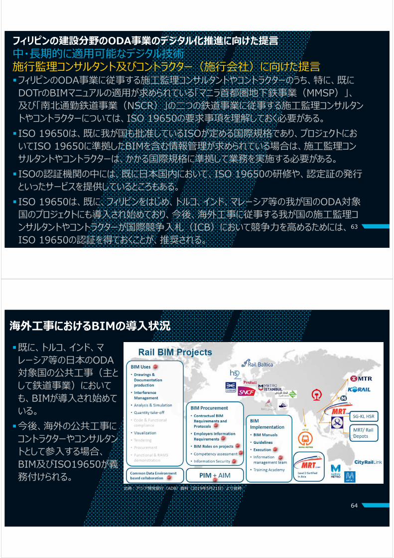
海外⼯事におけるBIMの導⼊状況既に、トルコ、インド、マレーシア等の⽇本のODA対象国の公共⼯事(主として鉄道事業)においても、BIMが導⼊され始めている。今後、海外の公共⼯事にコントラクターやコンサルタントとして参⼊する場合、BIM及びISO19650が義務付けられる。

ご清聴ありがとう
ございました株式会社アンジェロセック
株式会社⽚平エンジニアリング・インターナショナル国際航業株式会社