improvement scheme no. 1 - ashburton north strategic
TRANSCRIPT
IMPROVEMENT SCHEME NO. 1:
ASHBURTON NORTH STRATEGIC INDUSTRIAL AREA
Scheme Report
Western Australian Planning Commission
(Version Updated 3 August 2016)

Disclaimer
This document has been published by the Western Australian Planning
Commission. Any representation, statement, opinion or advice expressed or
implied in this publication is made in good faith and on the basis that the
government, its employees and agents are not liable for any damage or loss
whatsoever which may occur as a result of action taken or not taken, as the case
may be, in respect of any representation, statement, opinion or advice referred to
herein. Professional advice should be obtained before applying the information
contained in this document to particular circumstances.
© Western Australian Planning Commission
Published by the
Western Australian Planning Commission
Gordon Stephenson House
140 William Street
Perth WA 6000
Locked Bag 2506
Perth WA 6001
Published August 2016
website: www.planning.wa.gov.au
email: [email protected]
tel: 08 6551 9000
fax: 08 6551 9001
National Relay Service: 13 36 77
infoline: 1800 626 477
This document is available in alternative formats on application to
Communication Services.
TABLE OF CONTENTS
1 INTRODUCTION ................................................................................................................................................... 2 1.1 ASHBURTON NORTH STRATEGIC INDUSTRIAL AREA BACKGROUND ....................................................................... 2 1.2 ANSIA IMPROVEMENT SCHEME PURPOSE ............................................................................................................... 2
2 WHAT IS AN IMPROVEMENT SCHEME? .................................................................................................................. 3
3 SITE CONTEXT ...................................................................................................................................................... 4
4 ANSIA PLANNING BACKGROUND .......................................................................................................................... 5 4.1 LOCAL PLANNING SCHEME AMENDMENTS ............................................................................................................. 5 4.2 ANSIA STRUCTURE PLAN .......................................................................................................................................... 5 4.3 WHEATSTONE DEVELOPMENT PLAN ....................................................................................................................... 7 4.4 ANSIA STAGE 1B & 1C DEVELOPMENT PLAN ........................................................................................................... 8 4.5 EASTERN GENERAL INDUSTRIAL AREA OUTLINE DEVELOPMENT PLAN .................................................................. 8 4.6 SUMMARY ................................................................................................................................................................. 9
5 ANSIA IMPROVEMENT PLAN NO. 41 .................................................................................................................... 11 5.1 ANSIA IMPROVEMENT PLAN BOUNDARY .............................................................................................................. 11
6 ANSIA IMPROVEMENT SCHEME .......................................................................................................................... 15 6.1 ZONING ................................................................................................................................................................... 15 6.2 ANSIA IMPROVEMENT SCHEME PROVISIONS......................................................................................................... 17
7 GUIDE PLAN ..................................................................................................................................................... 21 7.1 GUIDE PLAN BASIS .................................................................................................................................................. 21 7.2 OPPORTUNTIES AND CONSTRAINTS ....................................................................................................................... 23 7.3 LAND USE AND ZONE REQUIREMENTS .................................................................................................................. 26 7.4 SITES FOR FUTURE INVESTIGATION ........................................................................................................................ 29
8 TECHNICAL DOCUMENTATION......................................................................................................................... 33
9 BIBLIOGRAPHY ................................................................................................................................................ 36
Appendix A Environmental Assessment Report ................................................................................................... 37
Appendix B Engineering Gap Analysis Report ..................................................................................................... 38
Appendix C Economic and Market Analysis ........................................................................................................ 39

List of Abbreviations used:
ANSIA: Ashburton North Strategic Industrial Area
CUCA: Common User Coastal Area
EAR: Environmental Assessment Report
EPA: Environmental Protection Authority
GIA: General Industrial Area
LNG: Liquefied Natural Gas
MDP: Model and Deemed Provisions
MUAIC: Multi-User Access and Infrastructure Corridor
ODP: Outline Development Plan
P&D Act: Planning and Development Act 2005
PPA: Pilbara Ports Authority
SCA: Special Control Area
SU1: Special Use Zone No. 1
TPS7 Shire of Ashburton Town Planning Scheme No. 7

2
1 INTRODUCTION
1.1 ASHBURTON NORTH STRATEGIC INDUSTRIAL AREA BACKGROUND
In 2008, the Western Australian (WA) State Government determined that a new hydrocarbon processing precinct
be established in order to derive maximum benefit from substantial gas discoveries off the North West coast. The
Ashburton North Strategic Industrial Area (ANSIA) was subsequently established. Located 12 kilometres south west
of the town of Onslow, the ANSIA provides for the development of Liquefied Natural Gas (LNG) production and
domestic natural gas, other hydrocarbon based processing industries, and associated support industries. The
ANSIA has a critical role in providing for future energy needs by taking advantage of hydrocarbon resources found
in the Carnarvon and Exmouth Basins.
The ANSIA comprises approximately 8,000 hectares of Crown land and freehold land owned by the Western
Australian Land Authority (LandCorp). Within the ANSIA a number of lease arrangements currently exist in order to
facilitate the use and development of the land. These include the Macedon Domgas Plant currently in operation
and the Wheatstone LNG Project under construction.
The ANSIA consists of land designated for strategic industry, general industry, port purposes, workforce
accommodation, and a Multi-User Access and Infrastructure Corridor (MUAIC). The Port of Ashburton (Port),
managed by the Pilbara Ports Authority (PPA), is intrinsic to the development of the strategic industry area. A
MUAIC provides connectivity between industry sites and the Port.
The Department of State Development (DSD) is the Lead Agency for the ANSIA and LandCorp is the industrial
estate manager, landowner and lessor. When considering Business Case submissions from future industry
proponents seeking to establish within the ANSIA, DSD and LandCorp will consider the proposal in the context of
existing developments in the ANSIA, the Improvement Scheme, and the supporting technical reports and
operational requirements of the ANSIA. This is to ensure the ANSIA is developed to its full potential, namely to
establish hydrocarbon processing industries and associated support activity. This process occurs well before the
lodgement of a Development Application with the Western Australian Planning Commission (WAPC).
1.2 ANSIA IMPROVEMENT SCHEME PURPOSE
The ANSIA is of strategic economic significance to the State. Consequently, the State identified the need to
provide a statutory planning framework that reflects this significance to the State’s economy and as far as
practicable provide improved project ready capacity.
Improvement Plan No. 41 – Ashburton North Strategic Industrial Area (Improvement Plan) was prepared pursuant
to the Planning and Development Act 2005 (P&D Act) and gazetted in March 2015. This provided the head of
power for the preparation of the ANSIA Improvement Scheme (Improvement Scheme).
The aims of this Scheme are to -
1. create a strategic industrial estate comprising major hydrocarbon processing industries and synergistic services and/or facilities with viable port access;
2. ensure the safe and efficient use of land for the long-term industrial development of a strategic industrial area of
regional, state and national significance;
3. provide an internationally competitive industrial estate that offers a layout designed to facilitate and encourage industry synergies, functional transport links and where possible, the sharing of infrastructure networks and corridors;
4. minimise and mitigate adverse impacts on the surrounding land, the terrestrial and marine environment, and the
Onslow community; and
5. ensure the appropriate separation and layout of land uses through appropriate internal and external buffers to
prevent incompatible or conflicting land uses.

3
2 WHAT IS AN IMPROVEMENT SCHEME?
2.1 STATUTORY CONTEXT
The P&D Act enables the WAPC to prepare Improvement Plans and Improvement Schemes. Improvement Schemes
are prepared by the WAPC as if they are a local planning scheme and therefore are subject to the same
consultation and advertising requirements set out in the P&D Act and the Planning and Development (Local
Planning Schemes) Regulations 2015.
The Shire of Ashburton’s local planning scheme ceases to have effect to the extent of land included within the
Improvement Scheme area.
2.2 ANSIA IMPROVEMENT SCHEME REPORT PURPOSE
The purpose of this Improvement Scheme Report (Scheme Report) is to provide the context, rationale and
explanatory commentary outlining: the origins of the planning framework; the key considerations in establishing
the Improvement Scheme framework including the ANSIA Guide Plan; the rationale for decisions made; and the
direction taken during the preparation of the Improvement Scheme.
This Scheme Report is not part of the Improvement Scheme.
2.3 ANSIA IMPROVEMENT SCHEME REPORT OUTLINE
The Scheme Report provides the following information:
Site Context – an outline of the locational, environmental, social and development context of the ANSIA
and immediate surrounds.
ANSIA Planning Background – an outline of the works undertaken in establishing the planning framework to date and how this has allowed for existing development.
Improvement Plan No. 41 – an outline of the objectives of the Improvement Plan and the Improvement Plan boundary.
ANSIA Improvement Scheme – an outline of the strategic direction of the ANSIA, and the rationale for the provisions of the Improvement Scheme.
Guide Plan – an outline of the rationale behind the Guide Plan, land uses, subdivision, development and zone specific requirements.
Technical Documentation – an outline of the technical documentation relating to the ANSIA and which documents are relevant to each zone.

4
3 SITE CONTEXT
The Improvement Scheme area is situated approximately 12 kilometres south west of the town of Onslow, in the
Pilbara region of Western Australia as depicted in Figure 1 – Improvement Scheme Location and Area.
Figure 1 – Improvement Scheme Location and Area

5
4 ANSIA PLANNING BACKGROUND
Significant investigations, technical assessments and documentation have been undertaken, in order to establish
and develop the ANSIA. Work to date has primarily been for the purposes of providing a strategic industrial area
which is suitable for hydrocarbon processing industries and support facilities, promoting the common use of
infrastructure and industrial synergies. The framework has developed incrementally in order to reflect the varying
timeframes associated with the establishment of the major projects in the ANSIA.
Historically the planning has produced a suite of documents, the purpose and objectives of which are outlined
below. While no longer applicable in the current planning framework, these documents have been reviewed and
synthesised to inform the preparation of the Improvement Scheme and Guide Plan.
Figure 3 – ANSIA Planning Framework, at the end of this chapter, notes the hierarchy and timeline of
documentation that guided development of the ANSIA prior to the Improvement Scheme.
4.1 LOCAL PLANNING SCHEME AMENDMENTS
Numerous amendments (9, 10, 11, 17, and 18) to the Shire of Ashburton Town Planning Scheme No. 7 (TPS7) were
made to facilitate the rezoning of the land from ‘Rural’ to ‘Strategic Industry’, ‘Industry’ and ‘Special Use’ zones,
and ‘Other Purposes – Infrastructure’ reserve.
4.2 ANSIA STRUCTURE PLAN
In order to provide for the magnitude of the ANSIA, both in terms of the scale of development, and timeframes
involved, the ANSIA Structure Plan set out a staging plan for the development of the ANSIA as depicted in Figure 2
- ANSIA Structure Plan Staging.
The ANSIA Structure Plan provided the framework for the planning of land in Stage 1, which was segmented into
several phases:
1A – the Wheatstone LNG Plant, Common User Coastal Area (CUCA), Port, MUAIC, and the Wheatstone
workforce accommodation site;
1B – the Macedon Domestic Gas Plant, potential second LNG site and second workforce accommodation
site;
1C – general industrial areas.
Whilst the Structure Plan did not include provisions for the development of Stage 2, it did incorporate principles
for further development, which were intended to inform the basis for a secondary Structure Plan over Stage 2
land.

6
Figure 2 – ANSIA Structure Plan Staging

7
The objectives of the Structure Plan were to:
Ensure land will be specifically allocated for long term industrial development of regional, state or national
significance, primarily to facilitate major hydrocarbon processing industries, and also industries that realise
productivity and efficiency gains through proximity to the LNG plants located within the ANSIA;
Ensure land will be specifically allocated for industrial development that supports the ongoing operation of
hydrocarbon activities within the ANSIA and the Port/Common User Coastal Area;
Protect the primacy of the hydrocarbon industry by ensuring inappropriate or conflicting land uses that may
adversely affect the key hydrocarbon processing uses are not be permitted. In particular, no land use or
development should:
- Limit the ability of the key hydrocarbon processing industries or associated infrastructure to
achieve their ultimate planned capacity and operating efficiency; or cause an unacceptable off- site
impact on the amenity, health, safety and security of the ANSIA;
Ensure the efficient use of available land is encouraged, as well as collaboration between industries, in order
to minimise waste production and promote re-use and recycling of waste;
Ensure development is planned and managed to minimise impact on surrounding uses such as Onslow Salt,
including minimising flood impacts;
Ensure that all impacts on the Onslow community are suitably managed, and deliver social and economic
benefits to the township;
Ensure development is subject to arrangements that clearly demonstrate what measures will be in place to
limit the social and hard infrastructure impacts on Onslow. In particular, proponents are to be responsible for
the accommodation of all workers (including the direct workforce, contractors, subcontractors and
authorised visitors who have direct involvement with the development) are housed either at the ANSIA or
Council approved accommodation;
Ensure environmental values and community safety are properly recognised and respected through the
Scheme Amendment, Structure Plan, Development Plan and Planning Application processes;
Ensure development of individual sites within the ANSIA is considered in the context of the preferred
ultimate development to ensure all users can be appropriately serviced by essential infrastructure,
including:
- Water supply and sewerage infrastructure;
- Electricity infrastructure; and
- Roads which are constructed to an acceptable standard; and
Ensure funding and development of multi-user infrastructure within the ANSIA reflects arrangements
between the State and proponents.
4.3 WHEATSTONE DEVELOPMENT PLAN
The Wheatstone Development Plan was prepared specifically for land identified as Stage 1A associated with the
Wheatstone Project including: LNG plant site and domestic gas plant site, MUAIC, workforce accommodation and
the CUCA.
The objectives of the Wheatstone Development Plan were as per the objectives of the Structure Plan, listed above.

8
4.4 ANSIA STAGE 1B & 1C DEVELOPMENT PLAN
The ANSIA Stage 1B & 1C Development Plan was prepared for the remaining strategic industry area including the
Macedon Domestic Gas Plant site, the second workforce accommodation site (Stage 1B), and the general industrial
areas (Stage 1C).
The objectives of the Stage 1B & 1C Development Plan were:
To create a strategic industrial estate comprising major hydrocarbon processing industries and synergistic
services and/or facilities. The design of the estate shall achieve a high level of functionality and sustainability
through the efficient use of land and infrastructure while incorporating flexibility to respond to changes in
industry requirements;
To create a Strategic Industrial Area that provides suitable land for the development of major hydrocarbon
processing industries;
To provide an internationally competitive industrial estate that offers a layout designed to facilitate and
encourage industry synergies, functional transport links and viable port access;
To establish a General Industrial Area that provides an appropriate location to accommodate support
services to the ANSIA which will help foster economic growth of the region and the State, whilst
minimising the impact on Onslow;
To ensure that planning of the ANSIA will facilitate the delivery of social and economic benefits to the town
of Onslow and surrounding region;
To establish a Development Plan that provides future proponents with clear and concise direction for their
development within the ANSIA; and
To establish a Development Plan that can be used as a marketing tool for the ANSIA project, by the State,
both in direct discussions with potential proponents and in consultation with the community.
4.5 EASTERN GENERAL INDUSTRIAL AREA OUTLINE DEVELOPMENT PLAN
The Eastern General Industrial Area (GIA) - Outline Development Plan (ODP), provided detailed planning for the
Eastern GIA, in accordance with the Structure Plan and Stage 1B & 1C Development Plan.
The objectives of the Eastern GIA ODP were:
To create a functional GIA to support existing and proposed industry in Onslow and the ANSIA; to provide
opportunities for industrial development and business in Onslow; to be complimentary to Onslow’s Light
Industrial Area; and to provide diversity and innovation in the delivery of lots in the areas of:
- Lot size;
- Lot flexibility;
- Tenure; and
- Servicing.
To establish a GIA that provides an appropriate location to accommodate support services to the ANSIA
which will help foster economic growth of the region and the State, whilst minimising the impact on Onslow;
To develop a functional, flexible and efficient GIA which effectively uses land, servicing and resources;

9
To ensure the development responds to market demand and the context of the site within the ANSIA;
To enable land to be delivered to market at the earliest opportunity, whilst minimising expenditure on
temporary works where possible;
To assist in the delivery of social and economic benefits to the town of Onslow and the surrounding region;
To provide future proponents with clear direction for their proposed development within the GIA; and
To establish an ODP that can be used as a marketing tool for the ANSIA project, by the State, both in direct
discussions with potential proponents and in consultation with the community.
4.6 SUMMARY
All of the documentation outlined above was historically prepared in accordance with TPS7. The Structure Plan,
Wheatstone Development Plan, Stage 1B & 1C Development Plan and the Eastern GIA ODP were supported by a
range of technical reporting including extensive hydrological, environmental, servicing and utilities investigations,
along with various traffic and parking assessments and social impact assessments.
It is not intended that the Scheme Report re-document all of this previous work that has been undertaken, rather
that it recognise this previous work in the Scheme Report to provide direction as to the information required in the
future decision making process.

10
FIGURE 3 – ANSIA Planning Framework

11
5 ANSIA IMPROVEMENT PLAN NO. 41
Improvement Plan No. 41 was prepared pursuant to section 119 of the P&D Act to advance planning for the ANSIA,
conferring on the WAPC the authority to undertake the necessary tasks to plan for and facilitate the
implementation of the project on behalf of the WA State Government.
The purpose of the Improvement Plan was to establish the strategic planning and development intent, to provide
for a framework endorsed by the WAPC, and to provide guidance for the preparation of subsequent planning
documentation and approvals. This includes determination of the Improvement Plan boundary.
The Improvement Plan was gazetted on 13 March 2015, thus providing the head of power for the development of
the Improvement Scheme.
5.1 ANSIA IMPROVEMENT PLAN BOUNDARY
A critical aspect of the Improvement Plan was determining the Plan boundary, as it forms the basis of both the
Improvement Plan and the Improvement Scheme. The final Improvement Plan boundary was based on the
previous planning framework, an expansion east towards Onslow Road for utilities, as well as appropriate buffers
to preserve the integrity of the ANSIA.
5.1.1 ANSIA BUFFER CONSIDERATIONS
In order to reflect the principles of orderly and proper planning, the previous planning framework made provision
for the following internal and external buffers having consideration for the environmental and planning policies of
the Environmental Protection Authority (EPA) and the WAPC.
Workforce Accommodation and Western General Industrial Area
The ANSIA Structure Plan made provision for a 1 kilometre (1000 metre) ‘Land Use Sensitivity’ buffer from
the southern boundary of the western GIA over workforce accommodation sites. The aim of this buffer
was to ensure surrounding land uses would not adversely affect the health, safety or amenity of the workers
accommodation.
Strategic Industry Area
The ANSIA Structure Plan also made provision for a 3 kilometre risk, noise and air quality indicative buffer from the
strategic industry area with regard to the following planning and environmental criteria:
Risk – Guidance Statement No. 2 - Guidance for Risk Assessment and Management: Offsite individual risk
from Hazardous Industrial Plant at a risk level of one in a million per year or less;
Noise – Environmental Protection (Noise) Regulations 1997, at sensitive land uses being 35dB(A); and
Air Quality – Draft State Environmental (Air Quality) Policy 2009.
The modelling for the above environmental criteria in relation to planned users within Stage 1 noted that a
boundary of 3 kilometres provided an acceptable limit for the criteria. The aim of this buffer was to ensure that no
sensitive receptors as defined by State Planning Policy 4.1 were located within proximity to the ANSIA.
Existing recreational land uses were acknowledged to be located within this buffer, including the 3 Mile Pool, 5
Mile Pool, Ashburton River informal camping sites and the Old Onslow Town site. These sites were not considered
to be sensitive receptors given their informal nature and absence of any permanent structures.

12
5.1.2 ANSIA IMPROVEMENT SCHEME BUFFER REQUIREMENTS
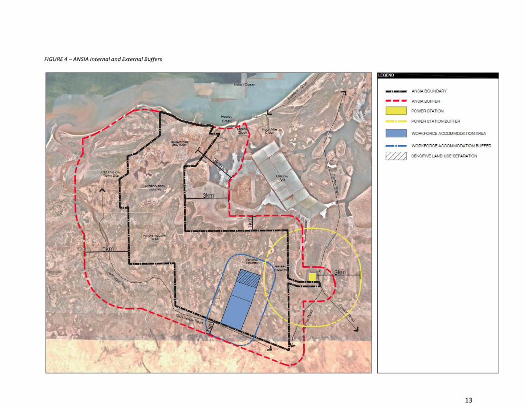
The Improvement Plan and Improvement Scheme boundaries as depicted on Figure 4 – ANSIA Internal and
External Buffers, incorporate the previous buffer consideration and the following assumptions:
1. A 3 kilometre buffer is provided from the areas designated for strategic industry and from the CUCA
which is intrinsic to the operations of the ANSIA. This buffer extends over the Onslow Salt State
Agreement area.
2. A 3 kilometre buffer is provided from the eastern edge of the MUAIC at the north eastern portion of the
strategic industry area. It is noted that there are significant environmental considerations relating to the
land between the MUAIC and the eastern boundary, thus rendering this land unsuitable for development
without significant further investigation. As such, at this time there is no foreseeable need to extend the
buffer in this direction, however it is noted that should the environmental constraints be resolved a
modification to the Improvement Plan and Improvement Scheme would be required.
3. A 3 kilometre buffer is provided from a proposed development site on the western boundary of the
strategic industry area has been proposed. It is noted that this buffer extends into the Old Onslow town
site, this is not considered to be a sensitive receptor and will not result in any adverse effects from the
ANSIA on the town site or vice versa.
4. A 1 kilometre buffer is provided from the remaining ANSIA area that includes the GIAs and workforce
accommodation sites. The 1 kilometre buffer provides for the protection of the workforce
accommodation from incompatible uses whilst allowing for a wide range of industrial uses to be
established. Uses which require a greater buffer may be considered on their merits and will be subject to
a detailed assessment and with the relevant approval authorities. It is noted that any approval to operate
with a reduced buffer will likely include restrictions on operations or additional requirements to ensure
there are no adverse effects on the sensitive uses.
5. A 3 kilometre buffer is provided from the proposed Horizon Power power station site. This site also
includes the proposed Water Corporation desalination plant.
The Improvement Plan boundary and subsequently Improvement Scheme boundary has been determined by
taking the outer limits of the various buffers described above and illustrated in Figure 5 - Improvement Plan
Boundary.
13
FIGURE 4 – ANSIA Internal and External Buffers

14
FIGURE 5 – ANSIA Improvement Plan Boundary

15
6 ANSIA IMPROVEMENT SCHEME
6.1 ZONING
In preparing the Improvement Scheme significant consideration has been given to the extensive body of work that
has already been undertaken, State Government decisions made and the direction as set out within the
Improvement Plan. These matters have influenced the zones and general development requirements included
within the Improvement Scheme.
6.1.1 DETERMINATION OF ZONES
The Improvement Scheme includes the following zones:
Strategic Industry zone;
General Industry zone;
Infrastructure zone;
Workforce Accommodation zone;
Industry Protection zone; and
Special Use zone.
In determining the Improvement Scheme zones primary consideration was given to the need to achieve a level of
consistency with the existing planning framework where appropriate and as far as practicable the associated
Improvement Scheme objectives. The following planning matters lead to the Industry Protection zone and
Infrastructure zone being introduced as new zones within the Improvement Scheme:
The need to establish and maintain separation distances between the strategic and general industrial uses
and sensitive receptors, both inside and outside of the Improvement Scheme area.
The unique infrastructure arrangements associated with strategic industry, effectively negating the need to set aside land as public reserves.
6.1.2 STRATEGIC INDUSTRY ZONE
The objective of the Strategic Industry zone is to provide for the establishment of hydrocarbon processing
industries including downstream processing industries and uses which are incidental to hydrocarbon processing.
The Strategic Industry zone makes up the core of the Improvement Scheme area, reflecting the intended use of
the ANSIA as a hydrocarbon processing precinct. The zone covers the existing Macedon and Wheatstone
developments. At its southern extent, it is anticipated that other industrial uses will be located so that they can
benefit from the close proximity to domestic gas supply and/or the Port.
The Strategic Industry zone incorporates the land based components of the Port of Ashburton. The Scheme
acknowledges that this land is controlled by the PPA under the Port Authorities Act 1999. The approval of the
Commission is not required for port works and port facilities in accordance with clause 36 of the Scheme.
Incorporation of this area into the Improvement Scheme maintains the intrinsic link between the port and
hydrocarbon processing precinct and provides for a suitable underlying zoning for any activities associated with
the ANSIA which do not form part of those works exempt under clause 36 of the Scheme.

16
6.1.3 GENERAL INDUSTRY ZONE
The objective of the General Industry zone is to provide for a wide range of general industrial uses.
The zone includes the eastern and western GIAs, generally intended to provide support to the larger developments
within the Strategic Industry zone as well as the wider Onslow region.
6.1.4 INFRASTRUCTURE ZONE
The objective of the Infrastructure zone is to provide for the establishment and unimpeded use of common user
infrastructure, access and transport corridors, and utility services.
6.1.5 WORKFORCE ACCOMMODATION ZONE
The objective of the Workforce Accommodation zone is to provide for the accommodation of workers engaged
in developments within the Ashburton North Strategic Industrial Area.
6.1.6 INDUSTRY PROTECTION ZONE
The objective of the Industry Protection zone is to protect industrial amenity of the ANSIA from encroachment by
uses that are not compatible with hydrocarbon processing and related activities, and to ensure sensitive uses are
not impacted upon by those processing and related activities.
This Scheme Report highlights a number of potential future investigation areas in the Industry Protection zone
within the ANSIA boundary. These sites are discussed in chapter 7 of this Report.
6.1.7 SPECIAL USE ZONE NO. 1
As noted in the Planning and Development (Local Planning Scheme) Regulations 2015, the application of Special
Use zones apply to “special categories of land uses which do not sit comfortably within any other zone in the
Scheme”.
The WA Government supports the use of the Wheatstone workforce accommodation site for the accommodation
of workers associated with the construction and ongoing operational requirements of the project and related
land uses. As such, Special Use zone No. 1 (SU1) is considered appropriate to deal with the unique circumstances
including:
Facilitating the effective use of existing infrastructure capacity, with a view to minimising the general demand
for, and proliferation of, workforce accommodation in the region.
Incorporating the existing accommodation, utilities and ancillary uses such as recreational facilities, convenience goods and amenities.
Facilitating the continued use of the northern portion of the SU1 for laydown, storage and other purposes, in a manner that:
a. Does not have adverse amenity impacts on workforce accommodation, and
b. Does not constrain land intended to be made available for industrial purposes within the GIAs.
The inclusion of Industry - noxious to allow for existing, constructed activities and new proposed activities
such a crushing, scrap metal, electric power generation, sewage facility, used tyre storage, solid waste
facility or depot, fuel burning for power, compost and bulk storage chemicals at the discretion of the
WAPC and on the advice of the agencies administering the Environmental Protection Act 1986 to
demonstrate compatibility.
17
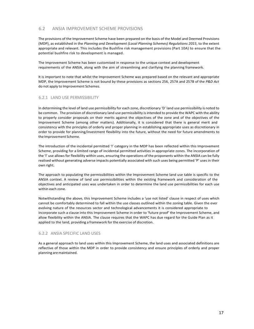
6.2 ANSIA IMPROVEMENT SCHEME PROVISIONS
The provisions of the Improvement Scheme have been prepared on the basis of the Model and Deemed Provisions
(MDP), as established in the Planning and Development (Local Planning Schemes) Regulations 2015, to the extent
appropriate and relevant. This includes the Bushfire risk management provisions (Part 10A) to ensure that the
potential bushfire risk to development is managed.
The Improvement Scheme has been customised in response to the unique context and development
requirements of the ANSIA, along with the aim of streamlining and clarifying the planning framework.
It is important to note that whilst the Improvement Scheme was prepared based on the relevant and appropriate
MDP, the Improvement Scheme is not bound by these provisions as sections 256, 257A and 257B of the P&D Act
do not apply to Improvement Schemes.
6.2.1 LAND USE PERMISSIBILITY
In determining the level of land use permissibility for each zone, discretionary ‘D’ land use permissibility is noted to
be common. The provision of discretionary land use permissibility is intended to provide the WAPC with the ability
to properly consider proposals on their merits against the objectives of the zone and of the objectives of the
Improvement Scheme (among other matters). Additionally, it is considered that there is general merit and
consistency with the principles of orderly and proper planning in establishing appropriate uses as discretionary in
order to provide for planning/investment flexibility into the future, without the need for future amendments to
the Improvement Scheme.
The introduction of the incidental permitted ‘I’ category in the MDP has been reflected within this Improvement
Scheme, providing for a limited range of incidental permitted activities in appropriate zones. The incorporation of
the ‘I’ use allows for flexibility within uses, ensuring the operations of the proponents within the ANSIA can be fully
realised without generating adverse impacts potentially associated with such uses being permitted ‘P’ uses in their
own right.
The approach to populating the permissibilities within the Improvement Scheme land use table is specific to the
ANSIA context. A review of land use permissibilities within the existing framework and consideration of the
objectives and anticipated uses was undertaken in order to determine the land use permissibilities for each use
within each zone.
Notwithstanding the above, this Improvement Scheme includes a ‘use not listed’ clause in respect of uses which
cannot be comfortably determined to fall within the use classes outlined within the zoning table. Given the ever
evolving nature of the resources sector and technological advancements it is considered appropriate to
incorporate such a clause into this Improvement Scheme in order to ‘future proof’ the Improvement Scheme, and
allow flexibility within the ANSIA. The clause requires that the WAPC has due regard for the Guide Plan as it
applied to the land, providing a framework for the exercise of discretion.
6.2.2 ANSIA SPECIFIC LAND USES
As a general approach to land uses within this Improvement Scheme, the land uses and associated definitions are
reflective of those within the MDP in order to provide consistency and ensure principles of orderly and proper
planning are maintained.

18
A review of the MDP definitions has been undertaken in relation to the specific characteristics of the existing and
future activities and operations within the ANSIA. It was determined that the following additional land use classes
were required to ensure the Improvement Scheme is fit for purpose and achieves the objectives set out under the
Improvement Plan:
Harbour and marine facilities;
Industry – hydrocarbon processing;
Industry – strategic extraction;
Supply base;
Workforce accommodation;
Utility – public; and
Utility – private.
6.2.2.1 INDUSTRY – HYDROCARBON PROCESSING
The definition of the industry – hydrocarbon processing has been prepared in order to ensure maximum efficiency
of hydrocarbon industries and associated infrastructure occurs within the Scheme area. The definition provides
for the core operations, whilst allowing flexibility for activities which are directly associated with, and support
industry – hydrocarbon processing.
In addition to the key inclusions of petroleum to produce liquefied natural gas, LPG, condensate, and/or other
hydrocarbon products, the definition explicitly includes ancillary activities (including certain prescribed premises)
such as wastewater treatment facilities, water supplies, desalination water production facility, electricity
generation plants, concrete batching plants, rock screening facilities, relevant administration buildings, internal
access and haul roads, and visitors centre/facilities as these are considered to be activities that enable the
hydrocarbon processing.
6.2.3 ADDITIONAL USES
An additional use has been inserted into the Scheme relating to Part Lot 500 on Deposited Plan 69197 Volume
2750 Folio 209 (as defined on the Scheme map). The additional use has been incorporated into the Scheme to
enable the continued use, of the Brolga workforce accommodation site by Chevron Australia Pty Ltd to a
maximum period of 31 December 2018 to support the growing workforce required to construct the Wheatstone
LNG Project (subject to maintaining current compliance with appropriate and relevant regulatory requirements).
The Shire of Ashburton’s Town Planning Scheme No. 7 limits the occupation of the Brolga workforce
accommodation site to 31 December 2016.
Within the additional use provisions, appropriate conditions have been placed on the operations, allowing
for workforce accommodation uses to operate on the site in addition to requirements for decommissioning
within 6 months of the operations ceasing.
6.2.4 EXEMPTIONS TO DEVELOPMENT APPROVAL
Permitted development within the Infrastructure zone does not require the development approval of the Commission. Permitted uses include telecommunication infrastructure and public and private utilities as defined by the Scheme. The Infrastructure zone is a combination of Crown land and freehold land in LandCorp and other State agency ownership. Easements and leases within the Infrastructure zone are granted to proponents at the discretion of the relevant authority. Leases are subject to a number of criteria to ensure the components of the Infrastructure zone fulfil the required functions.
Part of the land included within this Improvement Scheme is controlled by the Pilbara Ports Authority under the Port Authorities Act 1999. The approval of the Commission is not required for port works and port facilities undertaken, constructed or provided on land controlled by the Pilbara Ports Authority.
With respect to land under the control of the Onslow Solar Salt Agreement Act 1992 (Onslow Solar Salt Agreement), approval of the Commission is not required where development is in accordance with or as contemplated by or under the Onslow Solar Salt Agreement.

19
6.2.5 GENERAL DEVELOPMENT REQUIREMENTS
The general development requirements have been established by way of a comprehensive review of the existing
suite of documents (including TPS7, Structure Plan, and Development Plans). This was then compared for
consistency against Development Plan and Improvement Scheme provisions for other WA Strategic Industrial
Areas such as Boodarie, Browse, Anketell and Kemerton.
Aspects which affect development within the ANSIA, irrespective of the zone have been provided for within the
general development requirements of the Improvement Scheme, with more specific zone requirements being
incorporated into the Guide Plan.
6.2.6 APPLICATIONS FOR DEVELOPMENT APPROVAL
To a large extent the MDP requirements for development approvals are considered relevant in the Improvement Scheme context. Land within the Improvement Scheme area has been zoned appropriately so as to allow for the application and determination of development approvals in accordance with the provisions of this Improvement Scheme. Variations have been made to the MDP standard provisions to reflect the WAPC role in assessing and determining applications for development approval. Upon receipt of applications the WAPC may refer the application to Local Government for comment, along with any other agency the WAPC considers is appropriate.
In considering an application for development approval, the WAPC shall generally have regard to the matters set out in the Improvement Scheme text. In considering the strategic importance of the site and the intentions as a hydrocarbon processing precinct, additional matters for consideration have been identified.
In addition to providing guidance for the WAPC in its consideration of applications for development approval, it is intended that these provisions will guide proponents in the preparation of development applications and provide guidance on the rationale required to be incorporated into applications.
6.2.6.1 PROCEDURE FOR DEALING WITH WORKFORCE ACCOMMODATION APPLICATIONS FOR DEVELOPMENT APPROVAL
The matters to be taken into consideration by the Commission, and the procedures for dealing with development
applications for workforce accommodation, have been specifically tailored in recognition of the ANSIA as a strategic
industrial area.
When considering a development application for workforce accommodation the Commission will need to consider the following:
i) the length of time a workforce accommodation proposal should be approved;ii) appropriate setbacks from existing and proposed industrial development;iii) intended strategies to manage the economic and social impact of the proposal on Onslow;iv) intended strategies to manage the health and wellbeing of workers;v) the timeframe of any corresponding lease for that land;vi) the workforce accommodation requirements for the project; andvii) any other matter the Commission considers relevant.
To ensure land use compatibility for both the workforce accommodation and the industrial uses, the Commission will
consider the impact from any potential sensitive land use, in this instance workforce accommodation, on any existing or
proposed development for strategic industrial purposes and vice versa.
In this regard, the scheme requires that workforce accommodation whether located in the ‘Special Use’ zone or the
‘Workforce Accommodation’ zone is approved for a specified period to enable the Commission to undertake periodic
assessment of any effect on strategic industrial development.

20
6.2.7 MODEL AND DEEMED PROVISIONS NOT INCLUDED
To ensure the planning framework of the Improvement Scheme is fit for purpose, a number of provisions
contained within the MDP have not been incorporated, as follows:
Reserves – all land within the Improvement Scheme area is proposed to be appropriately zoned for its intended general use. Land does not need to be set aside as a scheme reserve for a public purpose within this Improvement Scheme.
Special Control Areas (Schedule 1, Part 5) – there has been no identified need for a special control area/s to be established within the Improvement Scheme.
Heritage Protection (Schedule 2, Part 3) – Heritage Protection is a relevant planning consideration and is interwoven throughout the Improvement Scheme text. Heritage values will be considered under these provisions and therefore introducing a discrete part of the scheme is unnecessary. The exiting provisions sufficiently operate in conjunction with the Heritage of Western Australia Act 1990.
Structure Plans (Schedule 2, Part 4) – it is not envisaged that structure plans will be utilised in the detailed stages of planning within the ANSIA into the future. Rather than generating a structure plan, a Guide Plan is included in the Improvement Scheme. A Guide Plan, which is described in further detail in the following chapter 7, is the planning instrument that provides the next level of detail. The notion of a Guide Plan was formulated to enable it to be established at the same time as an Improvement Scheme. To achieve this, it was necessary to formulate a different set of arrangements – a planning instrument which is different to a structure plan, and hence not engaged by the matters of a structure plan. The term Guide Plan was employed to differentiate it from other types of planning instruments.
Local Development Plans (Schedule 2, Part 6) – it is not envisaged that local development plans will be utilised in the detailed stages of planning within the ANSIA into the future.
Development Contribution Plans (Part 7) – it is not envisaged that a Development Contribution Plan would be established within the ANSIA and therefore enabling provisions are not considered necessary. Development Contribution Plans are typically relevant to areas of fragmented multiple ownership. Major developments within the ANSIA are the subject of proponent agreements with the State and therefore Development Contribution Plans are not considered to be relevant.
For major projects in the ANSIA, the State Government has a framework for assessing State Government
provided infrastructure and service needs. This informs the State’s negotiations with major project
proponents on development agreements to manage the impacts of projects. The application of
management plans and strategies, is intended to assist in the identification and management of
impact of projects.

21
7 GUIDE PLAN
The Improvement Scheme establishes provisions allowing for the establishment and operation of a Guide Plan.
The Guide Plan forms an appendix to the Improvement Scheme.
7.1 GUIDE PLAN BASIS The basis for the Guide Plan is the amalgam of design and information from the ANSIA planning background documents discussed in chapter 4. The map contained in the Guide Plan is also largely based upon the Hydrological and Planning Study which subsequently informed the ANSIA Industrial Ecology Strategy. This was prepared in consideration of the site’s constraints and opportunities as part of the 1B & 1C Development Plan.
In addition, the content of the Guide Plan has been informed by several reports and studies undertaken as part of the Improvement Scheme’s preparation process. These include; Environmental Assessment Report; Engineering Review, and an Economic and Market Analysis Report.
The Guide Plan is not prescriptive (in the same way that a Structure Plan is) and is intended to be used as a guide by the WAPC in the assessment and determination of applications for planning approval.
Below, Figure 6 - ANSIA Development Areas and Future Investigation Areas, illustrates the input from the ANSIA planning background documents as well as the Industrial Ecology Strategy.
7.1.1 GUIDE PLAN DESIGN RATIONALE
The realisation of the industrial synergies is dependent upon future proponents’ type and location of
development, based on their own independent feasibility studies, which may or may not be in line with the Guide
Plan. The Guide Plan is therefore intended to provide a broad framework and be flexible in nature, enabling
applications to be considered on merits by the WAPC, having regard for the advice of relevant authorities.
The Guide Plan has developed based on the following key elements and considerations:
Utility synergies: shared use of utility infrastructure, mainly revolving around water and energy (e.g. water supply and recovery, cogeneration) and including industrial and general waste recycling and reuse;
Supply synergies: featuring local manufacturer and dedicated supplier of principal reagents for core process industries (e.g. production of nitrogen for industrial use). The main supply synergy is the provision of gas from the LNG and domestic gas processing plants;
By product synergies: the use of a previously disposed by-product (as solid, liquid, or gas, including heat) from one facility by another facility to produce a valuable by-product. This includes CO² for ammonium urea production, heat for desalination or process heat, and inorganic solid waste by products (such as construction and demolition waste); and
Service synergies: sharing of services and activities between industries (e.g. joint training of staff and sharing of maintenance contractors including the common visitor and training centre and general industry area(s).

22
FIGURE 6 – ANSIA Development Areas and Future Investigation Areas

23
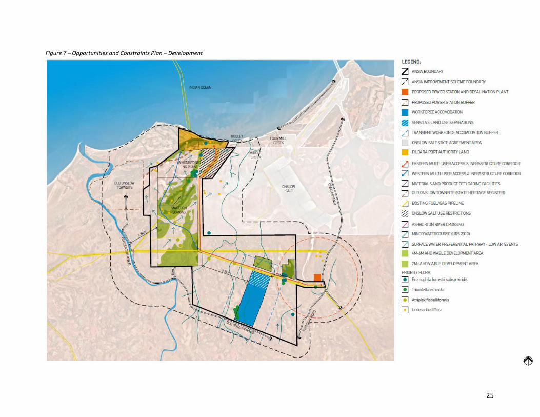
7.2 OPPORTUNTIES AND CONSTRAINTS
A summary of the key opportunities and constraints of the ANSIA and the surrounding environment are illustrated
in Figure 7 – Opportunities and Constraints Plan – Development and summarised in Table 1 - ANSIA Characteristics.
The full detailed opportunities and constraints are included within the technical reporting undertaken as part of
the Improvement Scheme process, in addition to the earlier Structure Plan and Development Plan appended
reports.
Table 1 – ANSIA Characteristics
CHARACTERISTIC SUMMARY
Geology The landform of the ANSIA is characterised by alluvial plains or sand plains with coastal flats and dunes. Tidal creeks, intertidal flats, saltpans, clay pans and coastal dunes can be found across the ANSIA.
Topography The ANSIA is dominated by topography consisting of undulating dunal systems, alluvial/colluvial plains and low lying coastal systems ranging from ~2m AHD to +20m AHD. Areas with a topographic elevation of +7m AHD are considered most viable for development, with areas of +4- 6m AHD being viable once subject to appropriate earthworks.
Surface Hydrology The ANSIA is subject to the hydrological impacts of the Ashburton River Delta and tidal inundation (storm surge). The ANSIA also contains clay pans and saltpans which fill and evaporate periodically.
Tidal movement through the sand dunes can result in tidal flows entering expansive tidal flat embayments a significant distance from the coast. Areas lower than +2m AHD become inundated in storm events.
Flora There are no listed rare or endangered species within the ANSIA; however there are 5 known species of conservation significance. Extensive flora surveys have been undertaken in association with the existing development on the site.
There are mangrove systems on the boundary of and adjacent to the ANSIA which are currently being monitored and managed to minimise impacts on mangrove communities.
Fauna There are six threatened terrestrial species within the ANSIA which are likely to be impacted by the removal of suitable habitat caused by the development of the area. These species are well represented in the surrounding environment.
Aboriginal Heritage There are a number of known Aboriginal Heritage sites within the ANSIA boundary.
Heritage Old Onslow Townsite is within the Improvement Scheme area. It is a permanent entry on the Register of Heritage Places (P3444 2006). The site also includes the remnants of the tramline and jetty which track through the north western portion of the ANSIA. Old Onslow townsite and associated community facilities can be accessed via Old Onslow Road.
Acid Sulphate Soils Much of the northern portion of the ANSIA is subject to possible or potential Acid Sulphate Soils (ASS). Testing on a broad level is not considered suitable as lithologies vary within the same geologic unit and as such testing at an individual development level would be required to ascertain the existence of ASS.
Onslow Townsite This is located approximately 12 kilometres to the north east of the ANSIA. The townsite accommodates approximately 600-1000 residents, and acts as a supply and service town for the Ashburton area and a base for many of the area’s tourism activities.

24
CHARACTERISTIC SUMMARY
Onslow Airport Reserve The Onslow Airport Reserve is approximately 10 kilometres east of the ANSIA. The Airport includes two runways which are used for general aviation and commercial operators. The second runway was added to allow for larger aircraft to transport the Wheatstone workforce.
The Reserve land consists of two stages of land surrounding the airport which are planned for development. The intention is to provide support services to the airport and to facilitate additional industrial land near Onslow.
Onslow Salt Located directly adjacent to the ANSIA is the land under the control of the Onslow Solar Salt Agreement. Onslow Salt is sensitive to changes in the hydrological conditions within the surrounding area. All developments within the surrounding hydrological catchment must be cognisant of the potential effects on Onslow Salt to ensure there are no adverse impacts. Accordingly, due regard must be given to the terms of the Onslow Solar Salt Agreement and the activities of Onslow Salt in accordance with and as contemplated by or under that agreement.
Watercourses - Hooley Creek / Middle Creek / Four Mile Creek, Quick Mud Creek and Ashburton River
The Ashburton River is located within the western portion of the Improvement Scheme area and is used by locals and tourists for informal camping and fishing purposes. The river can be accessed via Old Onslow Road and Twitchin Road.
Hooley Creek and Middle Creek are located within the north eastern portion of the Improvement Scheme area with Quick Mud Creek being located within the eastern aspect of the Improvement Scheme area.
Four Mile Creek is located to the east of the ANSIA and includes community facilities in the form of public picnic and fishing areas.
Major facilities and development at the ANSIA
Major facilities and developments within the ANSIA currently consists of the following:
- Macedon Domgas Plant; - Brolga Camp - temporary workforce accommodation currently used by the
Wheatstone Joint Venture; - Wheatstone Project site; - Wheatstone workforce accommodation; - Port of Ashburton land area which includes Wheatstone export infrastructure; - Infrastructure associated with the existing facilities; and - Multi-User Access and Infrastructure Corridor.
Separation Distances The current separation distances around the ANSIA include a 3 kilometre separation to the hydrocarbon industries and a 1 kilometre separation to the Wheatstone workforce accommodation area. These buffers have been determined through a review of Noise, Risk and Air Quality in order to protect the industrial amenity of the ANSIA from sensitive receptors. Refer to chapter 5 for further detail.
25
Figure 7 – Opportunities and Constraints Plan – Development

26
7.3 LAND USE AND ZONE REQUIREMENTS
Consistent with the Improvement Scheme, the Guide Plan is divided into a number of discrete planning zones that
are generally distinguished by different land use functions, as outlined below. The Guide Plan identifies further
development requirements and management plans that are required to accompany development applications.
The management plans vary depending on the zoning and intended use of the land.
By nature of the scale of a proponents investment, proponents of strategic industrial proposals are be expected to undertake appropriate due diligence including enquiries with the Government of Western Australia, to ascertain the requirements that will apply to their proposal, including the preparation of management plans. This is evidenced by significant level of previous planning and assessment undertaken for the ANSIA Structure Plan and more specifically Chevron’s Wheatstone project which informs the Improvement Scheme and Guide Plan.
Consequently, the zone specific development requirements do not require the provision of management plans relating to aspects which have been sufficiently assessed as part of prior bodies of work. Where however, this work has not been undertaken previously, the Commission will require evidence of pre lodgment consultation with stakeholders and government agencies.
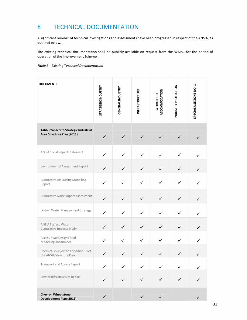
In order to facilitate an understanding of the technical documentation and to which area this relates, a matrix of relevant documentation is included at Table 2 - Existing Technical Documentation.
7.3.1 PORT AREA
The Port landside area is located within the Strategic Industry zone, but comes under the jurisdiction of the PPA. It
includes common user port facilities such as the materials offloading facility, laydown and storage areas, and
servicing infrastructure.
7.3.2 STRATEGIC INDUSTRY
Within the Strategic Industry zone, the Guide Plan shows indicative ‘islands’ of developable land based on the
technical studies undertaken, namely the hydrological study which identified overland flow paths. These indicative
development sites are proposed for hydrocarbon processing projects such as:
Urea and ammonia plant;
Ammonia nitrate plant;
Methanol plant;
Gas to liquids.
These have the potential to generate other ANSIA projects such as utility supply and resource recovery activities.
7.3.2.1 STRATEGIC INDUSTRY ZONE SPECIFIC REQUIREMENTS
Any proposal within the Strategic Industry zone likely, if implemented, to have a significant impact on the environment
or applications for subdivision within the Strategic Industry zone shall be referred to the EPA for assessment under
section 38 of the Environmental Protection Act 1986.
When considering development in the Strategic Industry zone, the Commission shall have regard to the following
management plans and studies (as relevant):
(a) Fire Management Plan;
(b) Mosquito Management Plan;
(c) Noise and Air Quality;
(d) Water Management Plan;
(e) Traffic Impact Assessment;
(f) Construction Environmental Management Plan;
(g) Servicing Strategy;

27
(h) Acid Sulphate Soil and Dewatering Management Plan;
(i) Terrestrial Weed Management;
(j) Marine Turtle Baseline Lighting Survey and Design Guidelines; and
(k) any other management plans and strategies the Commission considers relevant.
7.3.3 GENERAL INDUSTRY
Two multi-user estates for general industrial uses that support the key industries of the ANSIA are located to the
north eastern area of the ANSIA, fronting onto the MUAIC.
The development of the General Industry zone responds to the demand for industrial land associated with the
ANSIA. The GIAs will provide for a wide range of industrial activities to support the major industries and the wider
Onslow region.
The General Industry zone can accommodate supporting services required during the construction and operation
of ANSIA such as transport and logistics, pipeline integrity services, vehicle repair, construction and maintenance.
7.3.3.1 GENERAL INDUSTRY ZONE SPECIFIC REQUIREMENTS
The specific requirements to be addressed within the General Industry zone are conventional to GIAs, however, recognises the regional requirements and includes reference to a Mosquito Management Plan (where required).
When considering development in the General Industry zone, the Commission shall have regard to the following
management plans and studies (as relevant):
(a) Fire Management Plan;
(b) Mosquito Management Plan;
(c) Water Management Plan;
(d) Traffic Impact Assessment;
(e) Construction Environmental Management Plan;
(f) Servicing Strategy; and
(g) any other management plans and strategies the Commission considers relevant.
7.3.4 INFRASTRUCTURE
The Infrastructure zone is critical to the success of the ANSIA. The MUAIC as shown on the map in the Guide Plan
is designed to accommodate the various requirements for transport and transmission of products and utilities
within the ANSIA. The MUAIC will allow transportation and connectivity between the industries, joint or shared
operations, and will provide unencumbered access and connectivity to and from the Port.
The central MUAIC branches off to an eastern MUAIC, which has been developed through to the Port. The Eastern
MUAIC provides the primary road artery connecting the current industrial uses with the Port and the workforce
accommodation. There is also an indicative route for a western MUAIC to be constructed as and when required by
future major proponents.
The Infrastructure zone also includes the proposed Horizon Power power station and the proposed Water
Corporation desalination plant.
7.3.4.1 INFRASTRUCTURE ZONE SPECIFIC REQUIREMENTS
The Department of State Development and LandCorp in consultation with relevant State agencies (Department of
Mines and Petroleum and Department of Lands) determine the allocation of land within the Infrastructure zone to
proponents and service providers. Permitted development within the Infrastructure zone does not require the
development approval of the WAPC as noted within chapter 6.2.4 of the Scheme Report.
Where development approval is required, the Commission shall have due regard to any management plans and studies
the Commission considers relevant.

28
7.3.5 WORKFORCE ACCOMMODATION
The Workforce Accommodation zone is intended for a second workforce accommodation site. Its purpose being to
provide workforce accommodation within the ANSIA, close to the workplace whilst maintaining sufficient
separation to avoid any conflict in terms of industrial buffer requirements to workforce areas.
7.3.5.1 WORKFORCE ACCOMMODATION ZONE SPECIFIC REQUIREMENTS
An application for development approval is required for the construction of accommodation and related activities.
Land shall not be used for any activity that will cause any injury to or adversely affect the amenity of the
locality.
When considering development in the Workforce Accommodation zone, the Commission shall have regard to the
following management plans and studies (as relevant):
(a) Fire Management Plan;
(b) Mosquito Management Plan;
(c) Water Management Plan;
(d) Traffic Impact Assessment;
(e) Construction Environmental Management Plan;
(f) Servicing Strategy; and
(g) any other management plans and strategies the Commission considers relevant.
Applications for workforce accommodation are to address the range of considerations associated with
workforce accommodation including, but not limited to, the following:
(a) building locations;
(b) intended range and scope of land uses;
(c) movement network;
(d) arrangements for decommissioning; and
(e) any other matter the Commission considers relevant.
7.3.6 INDUSTRY PROTECTION
The Industry Protection zone ensures the hydrocarbon processing uses within the Strategic Industry zone are
protected from sensitive uses in perpetuity. Improvement Scheme provisions preclude uses (described as sensitive
uses) that could be impacted on by operations as a result of impacts such as: risk, noise, smoke, dust, odour, light
spill or vibration. The Industry Protection zone acknowledges the compatibility of the certain support activities
such as ‘public utility’ and ‘telecommunications infrastructure’ as well as ‘agriculture – extensive’.
7.3.6.1 INDUSTRY PROTECTION ZONE SPECIFIC REQUIREMENTS
When considering applications for development approval within the Industry Protection zone, the Commission
shall have due regard to matters including, but not limited to, the following:
(a) whether the proposal is compatible with any existing, proposed or potential future use or development within the Ashburton North Strategic Industrial Area Improvement Scheme;
(b) the potential environmental impacts including any advice provided under the Environmental Protection Act 1986;
(c) the terms of the Onslow Solar Salt Agreement and the activities of Onslow Salt in accordance with and as contemplated by or under that agreement;
(d) the existing, proposed or likely risks, hazards and nuisance (including but not limited to noise, odour and

29
light) associated with development within the Ashburton North Strategic Industrial Area Improvement Scheme;
(e) the potential impacts of the proposal on the efficient development of the Ashburton North Strategic Industrial Area;
(f) the activities necessary to support the effective heritage conservation of the Old Onslow townsite; and
(g) any other matter the Commission considers relevant.
7.3.7 SPECIAL USE ZONE NO. 1
The Wheatstone workforce accommodation site is included within SU1. As provided for within Table 2 of the
Scheme, SU1 allows for workforce accommodation together with utilities and ancillary uses such as recreational
facilities and convenience amenities.
Laydown, storage and a range of other uses may be located within a maximum distance of 1000 metres from
the southern boundary of the western GIA, as long as this does not have adverse amenity impacts on workforce
accommodation, and does not constrain land intended to be made available for industrial purposes within the
General Industry zone.
7.3.7.1 SPECIAL USE ZONE NO.1 ZONE SPECIFIC REQUIREMENTS
When considering development within the Special Use zone No. 1, the Commission shall have regard for the
following management plans (as relevant):
(a) Fire Management Plan;
(b) Mosquito Management Plan;
(c) Water Management Plan;
(d) Traffic Impact Assessment;
(e) Construction Environmental Management Plan;
(f) Servicing Strategy; and
(g) any other management plans and strategies the Commission considers relevant.
7.4 SITES FOR FUTURE INVESTIGATION
As shown on Figure 6 - ANSIA Development Areas and Future Investigation Areas, the map identifies sites for
‘Future Investigation’ to accommodate future potential industrial expansion if, and when, the demand arises.
These sites have been identified based on the previous investigations in relation to hydrological analysis.
Recommended developable areas, which have minimal flooding impacts (compared to other areas within the
study area) have been determined based on the following general criteria:
Identifying where existing paleo channels can be used for flooding and storm water;
Identifying where adequate buffering areas can be provide adjacent to paleo channels; and
Identifying areas where the minimum floor level can be 0.5m above the 1 in 100 annual exceedance probability (AEP) flood level without significantly raising the ground level.
Prior to the rezoning and subsequent development of sites for Future Investigation or other land in the Industry
Protection zone within the ANSIA boundary, proponents will be required to undertake the studies as referenced in
the following sub-chapters (as relevant), in addition to the provisions of the Improvement Scheme.
7.4.1 ENVIRONMENTAL CONSIDERATIONS
The ANSIA RPS Environmental Assessment Report (EAR) is included as Appendix A to this Scheme Report. Figure 8
– Environmental Assessments illustrates the land areas that have been previously subject to previous EPA
assessment. In those areas that have not been subject to EPA assessment, the following is recommended within
the EAR:

30
“A Level 1 flora survey consistent with Guidance Statement 51 (EPA 2004) should be conducted across the areas that have not been mapped and/or ground-truthed. Vegetation mapping by Biota (2010a) and Outback Ecology Services (2010) (reported in Biota 2010b) should be extrapolated across the unsurveyed areas as a desktop exercise. Ground-truthing should then be conducted for this mapping as well as the areas that were mapped by Biota (2010b) through aerial photography interpretation but were not ground-truthed;
A targeted flora survey is required in the habitats likely to support the conservation significant flora identified in previous surveys;
Surveys and ground-truthing should be conducted in the appropriate seasons;
A Level 1 fauna assessment to be undertaken to map fauna habitats across the study area as recommended by the “Ashburton North Strategic Industrial area Biological Desktop Review” (ENV 2012b); and
A targeted Level 2 fauna survey to determine the presence of any of the significant fauna species that are predicted by ENV (2012c) or RPS (2014b) as likely to occur.”

31
Figure 8 – Environmental Assessments

32
7.4.2 OTHER CONSIDERATIONS
Prior to the rezoning and development to be considered within the sites for Future Investigation, it will be
necessary for a proponent to investigate the required utilities to service the sites together with specific site
investigations. This should include (as documented by ARUP in the Engineering Gap Analysis Report) but is not
limited to the following:
Environmental Assessment Report.
Buffers from the Special Use zone and the Workforce Accommodation zone – As identified within the Scheme and Section 5.1.2 of this report.
Utilities –
- Water estimates with water recycling/synergy opportunities should be fed into the water supply
investigation. This will enable more meaningful evaluation of the supply options, considering the
‘business as usual’ and ‘total water cycle efficiency’ scenarios.
- Power demand estimates, power supply options, telecoms investigation and enquiries.
Traffic and Transport - confirmation of previously reported information, such as land use assumptions, projected staffing levels etc. and new information for the proposed expansions areas in order to adequately quantify traffic impacts.
Hydrology - areas of development set at the appropriate design level, will be a major input into initial earthworks and flooding investigation.
Site investigations - geotechnical and ASS would be targeted to specific areas.
Industrial Ecology - due consideration should be given to the cumulative impacts of the future ANSIA as a whole. Any potential benefit arising from synergies and early implementation of the servicing infrastructure should be assessed, to potentially reduce costs for individual developments, and increase attractiveness for proponents.
Any investigations outlined above that have not been the subject of prior approval would need to be prepared in
consultation with the Department of State Development, LandCorp and affected State agencies and entities with
evidence of pre-lodgement consultations with the relevant agency and entity.
33
8 TECHNICAL DOCUMENTATION
A significant number of technical investigations and assessments have been progressed in respect of the ANSIA, as
outlined below.
The existing technical documentation shall be publicly available on request from the WAPC, for the period of
operation of the Improvement Scheme.
Table 2 – Existing Technical Documentation
DOCUMENT:
STR
ATE
GIC
IND
UST
RY
GEN
ERA
L IN
DU
STR
Y
INFR
AST
RU
CTU
RE
WO
RK
FOR
CE
ACC
OM
MO
DA
TIO
N
IND
UST
RY
PR
OTE
CTIO
N
SPEC
IAL
USE
ZO
NE
NO
. 1
Ashburton North Strategic Industrial Area Structure Plan (2011)
ANSIA Social Impact Statement
Environmental Assessment Report
Cumulative Air Quality Modelling Report
Cumulative Noise Impact Assessment
District Water Management Strategy
ANSIA Surface Water Cumulative Impacts Study
Access Road Design Flood Modelling and Impact Assessment
Chemicals Subject to Condition 19 of the ANSIA Structure Plan
Transport and Access Report
Service Infrastructure Report
Chevron Wheatstone Development Plan (2012)

34
DOCUMENT:
STR
ATE
GIC
IND
UST
RY
GEN
ERA
L IN
DU
STR
Y
INFR
AST
RU
CTU
RE
WO
RK
FOR
CE
ACC
OM
MO
DA
TIO
N
IND
UST
RY
PR
OTE
CTI
ON
SPEC
IAL
USE
ZO
NE
NO
. 1
Social Impact Statement
Workforce Management Plan
Construction Traffic Management Plan
Mosquito Hazard Management Plan
Framework Construction Environment Management Plan
Local Water Management Strategy
Fire Prevention And Control Plan
ANSIA Stage 1B and 1C Development Plan Report (2012)
Biological Desktop Review
Level Two Flora and Vegetation Assessment
Level One Fauna assessment
Acid Sulphate Soil (ASS) Assessment
Industrial Ecology Strategy
Geotechnical Desktop Study
Hydrological and Planning Study
Local Water Management Strategy

35
DOCUMENT:
STR
ATE
GIC
IND
UST
RY
GEN
ERA
L IN
DU
STR
Y
INFR
AST
RU
CTU
RE
WO
RK
FOR
CE
ACC
OM
MO
DA
TIO
N
IND
UST
RY
PR
OTE
CTI
ON
SPEC
IAL
USE
ZO
NE
NO
. 1
European Heritage Technical Study
Traffic Impacts and Road Network Review
ANSIA Access Road Corridor Study Part A: Route Selection Study
ANSIA Truck Laydown Area Review
LandCorp Social Impact Statement
ANSIA General Industrial Area Outline Development Plan (2014)
Technical Traffic Note
Engineering Report
Flood Study
ANSIA Improvement Scheme (2015)
Environmental Assessment Report
Engineering Gap Analysis Report
Economic and Market Analysis

36
9 BIBLIOGRAPHY
ARUP 2015, Ashburton North Strategic Industrial Area Engineering Gap Analysis Report, Perth Western Australia
RPS Environmental and Planning (RPS) 2015, Environmental Assessment Report Ashburton North Strategic
Industrial Area, Perth, Western Australia
Shire of Ashburton 2004, Shire of Ashburton Town Planning Scheme No.7, Tom Price, Western Australia
Shire of Ashburton 2010, Amendment No.9 to Shire of Ashburton Town Planning Scheme No.7, Tom Price, Western
Australia
Shire of Ashburton 2011, Amendment No.11 to Shire of Ashburton Town Planning Scheme No.7, Tom Price,
Western Australia
Taylor Burrell Barnett (TBB) 2011a, Amendment No.10 to Shire of Ashburton Town Planning Scheme No.7, Perth,
Western Australia
Taylor Burrell Barnett (TBB) 2011b, Ashburton North Strategic Industrial Area Structure Plan, Perth, Western
Australia
Taylor Burrell Barnett (TBB) 2012, Wheatstone Development Plan, Perth, Western Australia
The Planning Group (TPG) 2012a, Amendment No.17 to Shire of Ashburton Town Planning Scheme No.7, Perth,
Western Australia
The Planning Group (TPG) 2012b, Amendment No.18 to Shire of Ashburton Town Planning Scheme No.7, Perth,
Western Australia
The Planning Group (TPG) 2012c, Ashburton North Strategic Industrial Area Stage 1B & 1C Development Plan
Report, Perth, Western Australia
Urbis 2014a, Ashburton North Strategic Industrial Area General Industrial Area – Eastern Portion Outline Plan of
Development, Perth, Western Australia
Urbis 2014b, Ashburton North Strategic Industrial Area Background Review, Perth, Western Australia
Worley Parsons 2015, Ashburton North Strategic Industrial Area Economic and Market Analysis, Perth, Western
Aust

37
Appendix A Environmental Assessment Report

38
Appendix B Engineering Gap Analysis Report

39
Appendix C Economic and Market Analysis