improved road condition reporting · improved road condition reporting study sd2001-15 final report...
TRANSCRIPT
South DakotaDepartment of TransportationOffice of Research
Connecting South Dakota and the Nation
SD2001-15-F
Improved Road Condition Reporting
Study SD2001-15 Final Report
Prepared by University of North Dakota Aerospace Foundation Grand Forks, ND, 58202-9023 November 2004

November 2004 ii SDDOT 2004 Road Condition Reporting System
DISCLAIMER
The contents of this report reflect the views of the authors who are responsible for the facts and accuracy of the data presented herein. The contents do not necessarily reflect the official views or policies of the South Dakota Department of Transportation, the State Transportation Commission, the South Dakota Highway Patrol, or the Federal Highway Administration. This report does not constitute a standard, specification, or regulation.
ACKNOWLEDGEMENTS
This work was performed under the direction of the SD2001-15 Technical Panel:
Jon Becker ............................................... Research Wayne Cramer..................................... Huron Area Tom Dravland .... SD Department of Public Safety John Forman............................Operations Support David Huft............................................... Research Sharon Johnson . Federal Highway Administration
John Kissack ............................Belle Fourche Area Capt. Rod Olerud.....................SD Highway Patrol Jana Pahl .......................SD Bureau of Information
& Telecommunications Ed Rodgers ..............................Operations Support Robert Smith.................................Rapid City Area
The work was performed in cooperation with the United States Department of Transportation Federal Highway Administration.
November 2004 iii SDDOT 2004 Road Condition Reporting System
TECHNICAL REPORT STANDARD TITLE PAGE
1. Report No. SD2001-15-F
2. Government Accession No.
3. Recipient's Catalog No.
5. Report Date November 22, 2004
4. Title and Subtitle Improved Road Condition Reporting
6. Performing Organization Code
7. Author(s) Bryan Hahn, Leon F. Osborne, Jr.
8. Performing Organization Report No. 10. Work Unit No.
9. Performing Organization Name and Address UND Aerospace Foundation 4201 University Avenue Grand Forks, North Dakota, 58202-9023
11. Contract or Grant No.
310774 13. Type of Report and Period Covered Final Report October 2001 to November 2004
12. Sponsoring Agency Name and Address South Dakota Department of Transportation Office of Research 700 East Broadway Avenue Pierre, SD 57501-2586
14. Sponsoring Agency Code
15. Supplementary Notes An executive summary is published separately as SD2001-15-X. 16. Abstract This report documents the design considerations and logical architecture of the South Dakota Road Condition Reporting System (RCRS). It details the database structure and entity relationships between the numerous data elements necessary to construct the RCRS. The study also reviews existing road condition reporting systems and contrasts these systems relative to criteria establish by South Dakota RCRS stakeholders. Process and data flow diagrams are developed using information engineering methodology. A context diagram is presented showing the external relationships to the RCRS. The process model includes a Level 0 data flow diagram showing details of the information flow between the primary processes. The data model includes entity relationship diagrams that show data major components and actions that exist between the entities. Data tables depicting the database schema are included in detail within the appendix and further define relationships between entities. The report describes the client application data entry interface with graphical examples. The flow of data to end users is presented along with recommendations for next generation research and development activities that will enhance the RCRS. 17. Keywords highway communications, data processing, incident management, road weather information systems, advanced traveler information systems, system architecture, integrated systems, integrated systems
18. Distribution Statement No restrictions. This document is available to the public from the sponsoring agency.
19. Security Classification (of this report) Unclassified
20. Security Classification (of this page) Unclassified
21. No. of Pages 62
22. Price

November 2004 iv SDDOT 2004 Road Condition Reporting System
November 2004 v SDDOT 2004 Road Condition Reporting System
TABLE OF CONTENTS
DISCLAIMER II
ACKNOWLEDGEMENTS II
TECHNICAL REPORT STANDARD TITLE PAGE III
TABLE OF CONTENTS V
LIST OF FIGURES VII
LIST OF TABLES VII
EXECUTIVE SUMMARY 1 PURPOSE OF STUDY 1 OBJECTIVES 1 RESEARCH TASKS 1 SIGNIFICANT FINDINGS 2 CONCLUSIONS 6 RECOMMENDATIONS 7
PROBLEM DESCRIPTION 10
STUDY OBJECTIVES 11
TASK DESCRIPTION 12 TASK 1: MEET WITH PROJECT PANEL 12 TASK 2: ASSESS AVAILABLE SYSTEMS 12 TASK 3: DESIGN LOGICAL AND PHYSICAL ARCHITECTURE 12 TASK 4: CONSTRUCT OPERATIONAL DATABASE 13 TASK 5: DEFINE OUTPUT PROCESSES 13 TASK 6: PILOT TEST DATABASE 14 TASK 7: RECOMMEND IMPROVED METHODS 14 TASK 8: CONDUCT OPERATIONAL FIELD TRIALS 14 TASK 9: RECOMMEND REPORTING PROCEDURES 14 TASK 10: PREPARE FINAL REPORT 15 TASK 11: MAKE EXECUTIVE PRESENTATION 15
FINDINGS 16 STRUCTURE OF RESEARCH EFFORTS 16
Identification of agencies involved 16 Identification of agency infrastructures available 16 Overview of agency visions of needed accomplishments 16 Identification of institutional barriers that might be encountered 17
REVIEW OF EXISTING ROAD CONDITION REPORTING SYSTEMS 18
November 2004 vi SDDOT 2004 Road Condition Reporting System
Highway Closure and Restriction System (HCRS) 19 Condition Acquisition and Reporting System (CARS) 20 Road Condition Reporting System Strength/Limitation Assessment 20 Road Condition Reporting System Review Findings 21
LOGICAL / PHYSICAL ARCHITECTURE AND OPERATIONAL DATABASE STRUCTURE 22 Basic Data Types and Interdependencies 24
Road Network Definition 24 Incident and Condition Definition 24 Location Definition 24 Time, Duration, and Recurrence Definition 25 South Dakota Law Enforcement Teletype System Reports 26 Definition of Primary Users and Authorization Levels 26
Road Condition Reporting System Database Schema 27 Situation [Traffic Management Data Dictionary (TMDD)] Tables 28 Road Network Tables 29 Geography Tables 29 User Administration Tables 30 Episode Report Tables 30
Data Input Methods 31 Manual Data Entry 31 Automated data entry from electronically available external sources 37
OUTPUT METHODS 38 Definition of end-user (customer) products 38 Means of dissemination 39
South Dakota 511 Traveler Information System 39 Region and state-wide text reports 39 Automated Permitting System 40 Automated Permitting System 41
Automated data extraction based on user-defined triggers 42 CONCLUSIONS 43
RECOMMENDATIONS 44
APPENDIX A—DATA TABLES 47

November 2004 vii SDDOT 2004 Road Condition Reporting System
LIST OF FIGURES
FIGURE 1: ROAD CONDITION REPORTING SYSTEM LOGICAL ARCHITECTURE CONTEXT DIAGRAM............4 FIGURE 2: LOGICAL ARCHITECTURE: LEVEL 0 DATA FLOW DIAGRAM........................................................5 FIGURE 3: RCRS CLIENT-SIDE APPLICATION FOR DATA ENTRY .................................................................6 FIGURE 4: LOGICAL ARCHITECTURE LEVEL 0 DATA FLOW DIAGRAM.......................................................23 FIGURE 5: ROAD CONDITION REPORTING SYSTEM LOGICAL ARCHITECTURE CONTEXT DIAGRAM..........28 FIGURE 6. ENTITY RELATIONSHIP DIAGRAM FOR RCRS LOGICAL ARCHITECTURE ..................................32 FIGURE 7: RCRS CLIENT APPLICATION FOR DATA ENTRY ........................................................................33 FIGURE 8: RCRS CLIENT APPLICATION ROAD CONDITION DIALOG BOX ..................................................35 FIGURE 9: RCRS CLIENT APPLICATION CONSTRUCTION INTERFACE.........................................................36 FIGURE 10:RCRS CLIENT APPLICATION CONSTRUCTION DIALOG BOX ....................................................36
LIST OF TABLES
TABLE 1. SUMMARY OF EXISTING RCRS SYSTEMS....................................................................................19 TABLE 2: STRENGTHS AND LIMITATIONS OF EXISTING ROAD CONDITION REPORTING SYSTEMS .............21 TABLE 3: EVALUATION OF HCRS AND CARS RELATIVE TO SDDOT DESIGN CRITERIA ..........................21 TABLE 4: ILLUSTRATIONS OF AMBIGUOUS ROAD CONDITION REPORTS....................................................26 TABLE 5: SITUATION [TRAFFIC MANAGEMENT DATA DICTIONARY] TABLES ...........................................29 TABLE 6: ROAD NETWORK TABLES ............................................................................................................29 TABLE 7: GEOGRAPHY TABLES...................................................................................................................30 TABLE 8: USER ADMINISTRATION TABLES .................................................................................................30 TABLE 9: EPISODE REPORT TABLES............................................................................................................31 TABLE 10: DISTRIBUTION OF AUTHENTICATION LEVELS FOR RCRS DATA ENTRY...................................34 TABLE 11: MAP DISPLAY TABLES...............................................................................................................34 TABLE 12: FIELDS COMMUNICATED TO THE AUTOMATED PERMITTING SYSTEM ......................................41 TABLE 13: FIELDS USED TO IDENTIFY RECURRENT EVENT TIMES.............................................................41 TABLE 14. REPORTABLE EVENTS AND CONDITIONS BY CATEGORY WITHIN THE AUTOMATED PERMITTING
SYSTEM ................................................................................................................................................42 TABLE 15: SITUATION TABLE: SITUATION_CATEGORIES ............................................................................47 TABLE 16: SITUATION TABLE: SITUATION_DESCRIPTIONS .........................................................................47 TABLE 17: SITUATION TABLE: SITUATION_DESCRIPTION_CATEGORIES.....................................................47 TABLE 18: SITUATION TABLE: SITUATION_QUALIFIERS .............................................................................47 TABLE 19: SITUATION TABLE: SITUATION_EXTENTS..................................................................................47 TABLE 20: SITUATION TABLE: SITUATION_DESCRIPTION_EXTENTS...........................................................48 TABLE 21: SITUATION TABLE: SITUATION_DESCRIPTION_QUALIFIERS ......................................................48 TABLE 22: SITUATION TABLE: SITUATION_DESCRIPTION_INFO .................................................................48 TABLE 23: SITUATION TABLE: SITUATION_ENUM_MEMBERS.....................................................................48 TABLE 24: SITUATION TABLE: SITUATION_ENUMS.....................................................................................49 TABLE 25: GEO TABLE: GEO_COUNTRIES ...................................................................................................49 TABLE 26: GEO TABLE: GEO_STATES..........................................................................................................49

November 2004 viii SDDOT 2004 Road Condition Reporting System
TABLE 27: HIGHWAY TABLE: HIGHWAYS ...................................................................................................49 TABLE 28: HIGHWAY TABLE: HIGHWAY_LINKS .........................................................................................50 TABLE 29: USER TABLE: USER_AGENCIES ..................................................................................................50 TABLE 30: HIGHWAY TABLE: HIGHWAY_DOMAIN_TYPES..........................................................................50 TABLE 31: HIGHWAY TABLE: HIGHWAY_DOMAINS....................................................................................50 TABLE 32: HIGHWAY TABLE: HIGHWAY_LINK_DOMAINS ..........................................................................51 TABLE 33: USER TABLE: USERS ..................................................................................................................51 TABLE 34: USER TABLE: USER_ALIASES.....................................................................................................51 TABLE 35: USER TABLE: AGENCY_IP_ADDRESSES .....................................................................................51 TABLE 36: HIGHWAY TABLE: HIGHWAY_PERMISSIONS..............................................................................51 TABLE 37: SITUATION TABLE: SITUATION_TEMPLATES .............................................................................52 TABLE 38: SITUATION TABLE: SITUATION_TEMPLATE_USERS ...................................................................52 TABLE 39: SITUATION TABLE: SITUATION_TEMPLATE_DESCRIPTIONS ......................................................52 TABLE 40: EPISODES TABLE: EPISODES.......................................................................................................52 TABLE 41: EPISODES TABLE: EPISODE_DESCRIPTIONS ...............................................................................53 TABLE 42: EPISODES TABLE: EPISODE_LOCATIONS....................................................................................53 TABLE 43: MAPS TABLE: MAPS ...................................................................................................................53 TABLE 44: MAPS TABLE: MAP_ICON_TYPES...............................................................................................54 TABLE 45: MAPS TABLE: MAP_ICONS .........................................................................................................54 TABLE 46: MAPS TABLE: MAP_ICON_COORDINATES..................................................................................54
November 2004 1 SDDOT 2004 Road Condition Reporting System
EXECUTIVE SUMMARY
PURPOSE OF STUDY The growth in public demand for improved safety and mobility during travel has been fostered by the existence of advanced traveler information systems such as South Dakota’s 511 Traveler Information System that provides weather and road condition information. Unfortunately, the resolution, both spatially and temporally, of the road condition information fails to match that of the weather information, and in many situations the road condition information, because of its age or due to rapidly changing conditions, is of little use to the traveler. The challenge of providing appropriate and timely road condition information is largely focused upon the high degree of manual processing necessary to collect, collate, organize, and distribute the information. Due to the excessive human resources needed to complete this task, the frequency of providing road information is only three times daily.
The purpose of the project SD2001-15 was to develop and demonstrate an efficient, effective, and timely mechanism for the collection and distribution of road condition information.
OBJECTIVES The objectives of this study were to:
Determine whether existing road condition information systems, including the Highway Condition Reporting System (HCRS) and the Condition Acquisition and Reporting System (CARS), satisfy South Dakota’s requirements for a flexible information management system that complies with national Intelligent Transportation Systems (ITS) standards.
Design, consistent with state information technology standards and methodology and with existing and emerging national Intelligent Transportation System standards, a logical and physical architecture for road and weather information.
Deploy for statewide use an operational road and weather database that can accept multiple manual and automated feeds and support multiple dissemination mechanisms.
Propose, test, and evaluate automated procedures for acquiring timely, location-specific road condition observations using present best communication methods and planned improvements to South Dakota’s state radio system.
RESEARCH TASKS The South Dakota Department of Transportation (SDDOT) retained the UND Aerospace Foundation and its subcontractor, Meridian Environmental Technology, Inc. to conduct the project. The Road Condition Reporting System research efforts consisted of eleven tasks:
1) Meet with the project’s technical panel to review project scope and work plan.
2) Through review of available documentation, assess and compare the capabilities of available road condition information systems, including HCRS and CARS.

November 2004 2 SDDOT 2004 Road Condition Reporting System
3) Using methodology acceptable to South Dakota’s Bureau of Information & Telecommunications (SDBIT) and to the Federal Highway Administration (FHWA), define and document the logical and physical architecture of the road and weather information system that is based on a relational database structure, can accept a variety of manual and automated input sources, and can feed information to various output media, including telephony, web sites, facsimiles, and e-mail.
4) Upon the project technical panel’s approval of the defined architectures, construct (possibly through adoption or modification of HCRS or CARS) an operational relational database that will support existing and future reporting and dissemination procedures.
5) Define and construct output processes that extract, summarize, and disseminate information to various output media (including telephony, web sites, facsimile, and e-mail) in various resolutions (by region, by road segment, and by mileage reference marker).
6) During the winter of 2001-2002, conduct a pilot test of the operational database, using existing methods for acquiring and disseminating road condition and weather information.
7) Identify, assess, and recommend evaluation plans for new or improved methods—such as expanded pools of reliable reporters, automated reporting, and use of standard protocols—for reporting road and weather conditions.
8) Upon approval of the project’s technical panel, conduct operational field trials of recommended methods for reporting road and weather conditions.
9) On the basis of effectiveness, practicality, and resource demands as demonstrated through the field trials and other analysis, recommends procedures to be deployed for reporting road and weather conditions.
10) Prepare a final report and executive summary of the research methodology, findings, conclusions, and recommendations.
11) Prepare and present an executive presentation to the Department’s Research Review Board at the conclusion of the project.
SIGNIFICANT FINDINGS The research resulted in several areas of significant findings. The first of these were the identification of criteria desired by state stakeholders for defining the South Dakota Department of Transportation Road Condition Reporting System (RCRS), including:
infrastructure to support statewide road condition reporting;
capability for rapid updating of information using a structured database management system;
support for multiple points of information distribution;
ability to handle current data sources including:
o road conditions
o road construction and maintenance
o incidents
November 2004 3 SDDOT 2004 Road Condition Reporting System
o emergency management events
ability to handle future possible sources of information and distributions;
use of rule sets supporting consistent reporting of local, geographically specific data;
support for manual and automated data sources;
support for multiple points of entry of data;
reliability with long mean time between failures;
easy to use software requiring minimal training;
conformance to SDBIT software design standards including:
o Microsoft SQL Server database support
o MS Windows client software composed in Visual Basic.
After criteria were established to define the SDDOT RCRS, a thorough review was performed to evaluate whether existing road condition reporting systems satisfied the SDDOT RCRS criteria and any could be adopted to expedite implementation and minimize the implementation costs. The review of existing systems focused on two widely adopted systems, the Highway Condition Reporting System and the Condition Acquisition and Reporting System. After a comprehensive review and application of the defined criteria for the SDDOT RCRS, it was recommended to the project Technical Panel that no existing system would meet the rigorous criteria for SDDOT. A recommendation was submitted and approved by the Technical Panel to develop a new RCRS to meet the SDDOT criteria. The specifics of the recommended client-server development were:
building a custom database and platform independent client data entry and manipulation system;
use of open source software and operating systems;
an SQL-compliant database;
all database access methods using database-independent access libraries, which will isolate the chosen database applications program interface (API) and transform it into one that is common to any database.
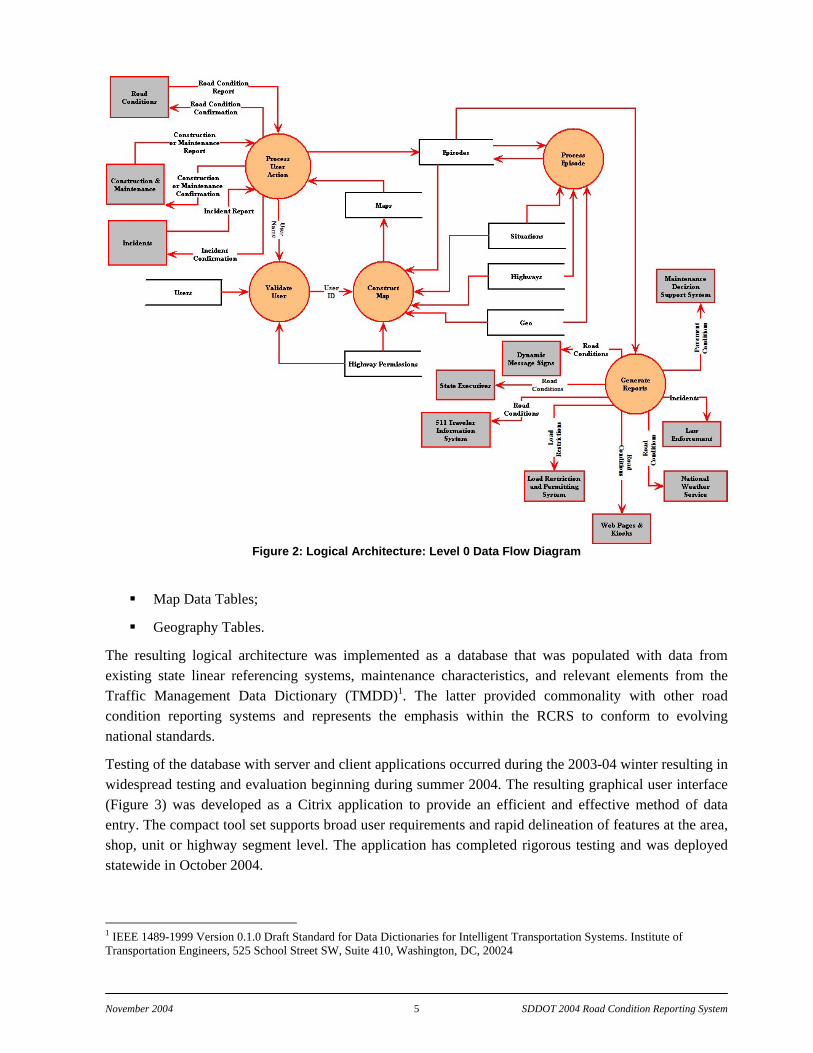
A major part of the road condition reporting system development process involved completing a logical and physical architecture of the SDDOT RCRS. This logical architecture consists of various processes, data flows, terminators, and data stores. Criteria used to define the architecture included:
establishing a relational database for all road conditions;
conformance, to the fullest extent possible, to the Traffic Management Data Dictionary standard;
geographical reference to South Dakota’s entire state highway network.
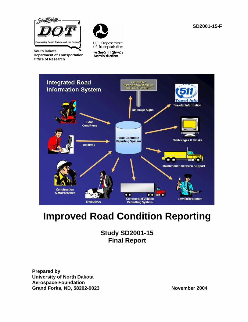
The overall design of the logical architecture is captured in a context diagram depicting the relationship of the external elements to the RCRS (Figure 1) and a Level 0 Data Flow Diagram that depicts the logical arch (Figure 2).

November 2004 4 SDDOT 2004 Road Condition Reporting System
Figure 1: Road Condition Reporting System Logical Architecture Context Diagram
The data stores found within the Data Flow Diagram represent the central challenge associated with the RCRS design. Due to the complex relationships that resulted between the various data types found within the architecture, creating appropriate database schemas to effectively represent the data and their interdependencies required significant design efforts. Considerable interaction with SDDOT personnel ensued to design a database schema that satisfied current and future data requirements. The data types incorporated in the architecture included:
road network definition;
incident/condition type definition;
incident/condition location definition;
incident/condition time/duration/recurrence definition.
These elements were analyzed to generate a database schema that included a series of 33 tables spanning six categories:
Situation [Traffic Management Data Dictionary (TMDD)] Tables;
Road Network Tables;
User Administration Tables;
Episode Report Tables;
November 2004 5 SDDOT 2004 Road Condition Reporting System
Figure 2: Logical Architecture: Level 0 Data Flow Diagram
Map Data Tables;
Geography Tables.
The resulting logical architecture was implemented as a database that was populated with data from existing state linear referencing systems, maintenance characteristics, and relevant elements from the Traffic Management Data Dictionary (TMDD)1. The latter provided commonality with other road condition reporting systems and represents the emphasis within the RCRS to conform to evolving national standards.
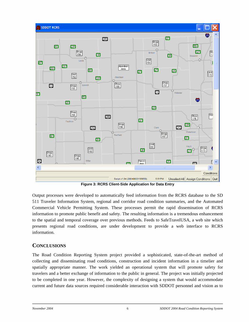
Testing of the database with server and client applications occurred during the 2003-04 winter resulting in widespread testing and evaluation beginning during summer 2004. The resulting graphical user interface (Figure 3) was developed as a Citrix application to provide an efficient and effective method of data entry. The compact tool set supports broad user requirements and rapid delineation of features at the area, shop, unit or highway segment level. The application has completed rigorous testing and was deployed statewide in October 2004.
1 IEEE 1489-1999 Version 0.1.0 Draft Standard for Data Dictionaries for Intelligent Transportation Systems. Institute of Transportation Engineers, 525 School Street SW, Suite 410, Washington, DC, 20024
November 2004 6 SDDOT 2004 Road Condition Reporting System
Figure 3: RCRS Client-Side Application for Data Entry Output processes were developed to automatically feed information from the RCRS database to the SD 511 Traveler Information System, regional and corridor road condition summaries, and the Automated Commercial Vehicle Permitting System. These processes permit the rapid dissemination of RCRS information to promote public benefit and safety. The resulting information is a tremendous enhancement to the spatial and temporal coverage over previous methods. Feeds to SafeTravelUSA, a web site which presents regional road conditions, are under development to provide a web interface to RCRS information.
CONCLUSIONS The Road Condition Reporting System project provided a sophisticated, state-of-the-art method of collecting and disseminating road conditions, construction and incident information in a timelier and spatially appropriate manner. The work yielded an operational system that will promote safety for travelers and a better exchange of information to the public in general. The project was initially projected to be completed in one year. However, the complexity of designing a system that would accommodate current and future data sources required considerable interaction with SDDOT personnel and vision as to
November 2004 7 SDDOT 2004 Road Condition Reporting System
how a database could be extensible to handle next generation data input and output. In addition, the level of database preparation and population exceeded the original estimates. This was particularly true with regards to the South Dakota road network database where discrepancies in the geospatial data did not permit direct incorporation within the RCRS database. Considerable effort was required to resolve these discrepancies, which significantly delayed the project completion. However, the resulting road network GIS is not only an excellent addition to the RCRS, it has provided a benefit to the SDDOT in general.
Several summary conclusions from the project include:
1. The generation of information with high spatial and temporal resolution requires special attention to details within the database design and high quality geospatial and attribute data to populate the dataset.
2. A well designed data entry methodology and associated graphical user interface are crucial to the acceptance of an application that involves a high degree of user interaction. While the database design will determine the extensibility of the information to end users of the system, having a method of input that facilitates user acceptance will largely determine whether the resulting system will be given the opportunity to succeed.
3. The successful completion of a project of this nature requires the commitment of a broad range of stakeholders all dedicated to maintaining a high degree of quality and end user support. To this end this project had such commitment from all participants and the resulting product should provide years of benefit to South Dakota.
RECOMMENDATIONS The further growth of information systems supporting improved information regarding the current state of the road network will be needed to keep pace with the demands of travelers and technologies that can use the information to further surface transportation products and services. The scale of information will continue to grow finer in time and space. This demand has already outpaced the capabilities of most states to manually produce the information to support these systems. Hence, it is recommended that the following efforts be considered for enhancing the work provided within this project.
Recommendation 1:The South Dakota Department of Transportation should pursue development of automated and semi-automated road condition reporting methods.
An expansion in the volume of road condition information will require both the time of field personnel and data entry personnel to support the use of the data within a road condition system unless improved methods are developed to more effectively incorporate these data within the RCRS. This can be done in two levels.
The South Dakota Bureau of Information and Telecommunications is in the process of awarding a contract to enable digital data support from radio systems distributed across South Dakota within SDDOT vehicles. With this system available it will be important to consider methods by which effective communications to the RCRS can be completed that will reduce dramatically the requirement for manual computer operator entry of information to the RCRS database. This capability for automated data entry will promote greater spatial and temporal details and provide for improved efficiency and safety from the RCRS. However, unknowns in the level of digital data support from state radio suggest efforts must also
November 2004 8 SDDOT 2004 Road Condition Reporting System
include methods for automated data entry that go beyond State Radio and include alternate means that consider other cost effective and efficient procedures. The use of automated data entry will require the solution of problems associated with three distinct areas: 1) data submission in a field environment; 2) data transmission and reception from remote vehicles and locales; and 3) translation and assimilation of received data into the present RCRS database.
The first of these research areas involves understand the most appropriate methods for remote entry from a field environment. This includes understanding data entry environments that will exist, such as SDDOT maintenance vehicles, SDDOT non-maintenance vehicles, and law enforcement vehicles. Depending upon which of these environments are chosen the type of data entry may vary due to the nature of data being entered and the capabilities of the personnel entering the data. This will likely define the form of data transmission and reception that will be possible. The reception of data has been included for situations where a feedback is required to the field data entry either as confirmation of successful transmission or the need to react to data submitted.
The methodologies recommended for investigation of data input directly from field sources include the following (forms of possible data transmission supported are listed in parentheses):
PDA—Portable Digital Assistant, an interactive handheld interface allowing selection and input of menu driven information, with telecommunication (Cellular or Radio);
Smart Cellular Phone—Automated Global Positioning System (GPS) data and interactive conditions menu system directed at an Interactive Voice Recognition (IVR) system for input of information, with telecommunications (Cellular);
Satellite Phone—Automated GPS data and interactive conditions menu system directed at an IVR system for input of information, with telecommunications (Satellite);
Radio—Interactive menu system directed at an IVR system for input of information, with telecommunications (Radio);
Cellular—Interactive menu system directed at an IVR system for input of information, with telecommunications (Cellular);
Mobile Reporting System—Small portable computer for input of information, with telecommunications (Cellular or Radio).
Recommendation 2: SDDOT should expand the present RCRS to support maintenance activities collection and reporting in conjunction with Maintenance Decision Support.
The current efforts to develop and deploy a Maintenance Decision Support System in South Dakota will require the detailed depiction of road state as well as the location and details of winter maintenance activities ongoing at all times. The maintenance activity data collection has a parallel development path to those identified above for semi-automated and automated road condition reporting. The expansion of the RCRS data collection to include maintenance activity data collection to support Maintenance Decision Support Systems is recommended. Various vendor solutions presently exist to integrate in-vehicle maintenance efforts and the expansion of these technologies is accelerating. Methods should be developed to promote these efforts such that an economy of scale with the automated road condition information collection can be realized.

November 2004 9 SDDOT 2004 Road Condition Reporting System
Recommendation 3: SDDOT should pursue a leadership position in the emerging national vehicle information infrastructure (VII) efforts.
A major national effort is underway to develop methods of exchanging information from commercial and private vehicles with the roadside environment. This effort will yield significant opportunities for enhancing data quality and timeliness throughout the road network. The technologies South Dakota will pursue, if the above recommendations are followed, will establish the State as a national leader in the exchange of information from the vehicle to the roadside. The lessons learned would be of significant benefit to the states where little consideration has yet to be given to maintenance issues within VII. It is recommended that appropriate representative from South Dakota routinely participate with the VII effort and such demonstration projects as appropriate be established in South Dakota to highlight the efforts of the RCRS and MDSS efforts relative to VII.
Recommendation 4: The South Dakota Department of Transportation should adopt the RCRS as its definitive database for road conditions.
The completion of the RCRS represents a major effort by the South Dakota Department of Transportation to establish a comprehensive database supporting the collection, management, and dissemination of information associated with the South Dakota road system. The database provides the capability for immediate system updates and distribution through database updates. The RCRS represents the state-of-the-art in road condition reporting. The adoption as the definitive database for road conditions will ensure that the most appropriate information is provided to support safety and mobility.
Recommendation 5: The South Dakota Department of Transportation should promote the use of the RCRS by other public safety organizations within South Dakota.
The RCRS is presently limited to input and viewing by South Dakota Department of Transportation personnel. However the RCRS provides a significant resource for use by public safety organizations across South Dakota. The capability of the RCRS to immediately distribute road condition information to a broad array of end users makes it a valuable resource for disseminating critical emergency information Statewide. Access to the RCRS for viewing current conditions will provided public safety organizations a means to facilitate appropriate responses to changing road conditions that impact these organizations and the public they serve. The input of emergency information by first responders, principally the South Dakota Highway Patrol, will enable a more effective and timely distribution of information related to rapidly changing road conditions.
Recommendation 6: The South Dakota Department of Transportation should update the South Dakota Statewide ITS Architecture to reflect the implementation of the RCRS.
The South Dakota Statewide ITS Architecture is a statewide vision for transportation systems integration. The architecture is a reflection of how existing and future systems respond to opportunities and operational needs of the transportation system and the organizations and individuals using the system. The implementation of the RCRS represents a significant addition to existing operational capabilities of the transportation system that should be documented within the Statewide ITS Architecture. Inclusion of the RCRS in the updated architecture will enable the capabilities of the RCRS to become better integrated into future transportation system designs.

November 2004 10 SDDOT 2004 Road Condition Reporting System
PROBLEM DESCRIPTION
The South Dakota Department of Transportation collects, analyzes, and disseminates information on road and weather conditions using a mix of automated and manual processes. Weather condition reports and forecasts are generated for the transportation departments of South Dakota and North Dakota by Meridian Environmental Technology, Inc. (Meridian) of Grand Forks, North Dakota. Using sophisticated forecasting techniques based on analysis of several national and local data sources, Meridian generates detailed, location-specific “nowcasts” and forecasts that are maintained in a relational database and automatically disseminated to various audiences, including state maintenance forces and the general public. The public receives this information through the Department of Transportation’s web site or via the South Dakota 511 system using Meridian’s #SAFE telephony-based traveler information system.
While weather information is computer-based and dynamically maintained, South Dakota’s road condition information is largely handled manually. Three times daily, maintenance supervisors verbally report their visual observations to a state radio dispatcher, who manually transcribes them and transmits them via Teletype. A seasonal employee of the Office of Operations Support reads and interprets the transcribed observations, and develops regional summaries of road conditions. After the regional summaries are keyed, they are relayed to media outlets via Teletype, e-mail, and Internet, and are recorded verbally for dissemination via regional phone numbers in Aberdeen, Sioux Falls, Pierre, and Rapid City. The summaries are also provided to the 511 system, but their regional resolution is not consistent with location-specific resolution of the 511 system weather information.
The growth in public demand for improved safety during travel has been fostered by the existence of advanced traveler information systems such as 511. The Meridian #SAFE technologies are adapted from prototype systems developed at the University of North Dakota in cooperation with the South Dakota and North Dakota Departments of Transportation. The #SAFE technologies use high spatial and temporal resolution weather information to support en-route travel safety. An equally important element of the system is the delivery of road condition information.
Unfortunately, the resolution, both spatially and temporally, of the road condition information fails to match that of the weather information, and in many situations the road condition information, because of its age or due to rapidly changing conditions, is of little use to the traveler.
The challenge of providing appropriate and timely road condition information is largely focused upon the high degree of manual processing necessary to collect, collate, organize, and distribute the information. Due to the excessive human resources needed to complete this task, the frequency of providing road information is only three times daily.
The focus of the project was to develop and demonstrate an efficient, effective, and timely mechanism for the collection and distribution of road condition information.

November 2004 11 SDDOT 2004 Road Condition Reporting System
STUDY OBJECTIVES
The objectives of this study were to:
Determine whether existing road condition information systems, including the Highway Condition Reporting System (HCRS) and the Condition Acquisition and Reporting System (CARS), satisfy South Dakota’s requirements for a flexible information management system that complies with national Intelligent Transportation Systems (ITS) standards.
Design, consistent with state information technology standards and methodology and with existing and emerging national Intelligent Transportation System standards, a logical and physical architecture for road and weather information.
Deploy for statewide use an operational road and weather database that can accept multiple manual and automated feeds and support multiple dissemination mechanisms.
Propose, test, and evaluate automated procedures for acquiring timely, location-specific road condition observations using present best communication methods and planned improvements to South Dakota’s state radio system.
November 2004 12 SDDOT 2004 Road Condition Reporting System
TASK DESCRIPTION
The eleven Project Tasks stated in the request for proposal are listed below in italics, with accompanying descriptions of the approach taken.
TASK 1: MEET WITH PROJECT PANEL Meet with the project’s technical panel to review project scope and work plan.
A meeting was held on the afternoon of November 16, 2001 with the project technical panel at SDDOT headquarters in Pierre, South Dakota to discuss the scope of work and the work plan of the project. The meeting had representatives from SDDOT, the South Dakota Bureau of Information and Telecommunications (SDBIT), the Federal Highway Administration, the University of North Dakota Aerospace Foundation (UNDAF), and UNDAF’s subcontractor for this project, Meridian Environmental Technology, Inc. (Meridian).
TASK 2: ASSESS AVAILABLE SYSTEMS Through review of available documentation, assess and compare the capabilities of available road condition information systems, including HCRS and CARS.
A list of road condition information systems in existence at the time of project initiation was compiled through contacts with DOT personnel in other states and a review of available on-line resources. The review of the simple transcription systems or radio and telephone reports was not included as they failed to provide the level of sophistication specified in the project guidelines. Special attention was provided to the two most widely used road condition reporting systems at present at the time, the Highway Closure and Restriction System (HCRS) and the Condition Acquisition and Reporting System (CARS), in the assessment process. The assessment of all systems consisted of the identification of strengths and limitations of existing systems according to each system’s:
incorporation of Advanced Traveler Information Systems (ATIS) standards;
operating requirements;
compliance with South Dakota Bureau of Information and Technology guidelines; and
extensibility to adapt to future data input and output capabilities.
A comparison of the assessed strengths and weakness was completed and used to formulate a recommendation to SDDOT on the direction to follow for implementation of a road condition reporting system. The findings were presented to SDDOT, which used the information to define the scope of the further tasks associated with design and construction of the road condition reporting system.
TASK 3: DESIGN LOGICAL AND PHYSICAL ARCHITECTURE Using methodology acceptable to South Dakota’s Bureau of Information & Telecommunications and to the Federal Highway Administration, define and document the logical and physical architecture of the road and weather information system that is based on a relational database structure, can accept a
November 2004 13 SDDOT 2004 Road Condition Reporting System
variety of manual and automated input sources, and can feed information to various output media, including telephony, web sites, facsimiles, and e-mail.
A review was conducted with SDDOT and SDBIT personnel to identify the accepted database methods that could be considered in a road condition reporting system design. Material on SDBIT standards was acquired from the SDBIT web page (http://www.state.sd.us/standards/index.htm) and reviewed. A review of the South Dakota Rural ITS Architecture (http://www.consystec.com/dakota/southdakota/ southdakotaintro.htm) was conducted to identify sources and destinations of data and information associated with new road condition reporting system design. The linkages between the RCRS and elements within the National ITS Architecture (http://www.state.sd.us/standards/index.htm) were reviewed. Telephone conferences were held with SDDOT personnel to discuss South Dakota desired output media and how these were expected to be interfaced to the RCRS. The result of the various meetings and the direction of the project’s Technical Panel relative to the Task 2 findings provided guidance on defining the logical and physical architecture. Definitions of the relational database structure, including definitions of database schema, were routinely discussed with SDDOT research personnel to ensure that appropriate capture of data and relationships between data were made. Periodic meetings and phone conferences were held to review architecture design.
TASK 4: CONSTRUCT OPERATIONAL DATABASE Upon the project technical panel’s approval of the defined architectures, construct (possibly through adoption or modification of HCRS or CARS) an operational relational database that will support existing and future reporting and dissemination procedures.
A Technical Panel meeting was held on May 20, 2002 to consider the recommended architecture to provide a new RCRS design to support SDDOT requirements. Upon approval by the Technical Panel to proceed following the recommendation made, an operational database was constructed that incorporated the logical and physical design reviewed and approved by the project Technical Panel. The construction of the operational database required the incorporation of elements from the SDDOT geographical information system including the state road network and aspects from some of the thirteen linear referencing systems used in South Dakota. The geographic reference systems used were the Highway and Mileage Reference Markers and latitude and longitude. The operational database was populated with information from these systems upon rectification of errors found within aspects of the system.
TASK 5: DEFINE OUTPUT PROCESSES Define and construct output processes that extract, summarize, and disseminate information to various output media (including telephony, web sites, facsimile, and e-mail) in various resolutions (by region, by road segment, and by mileage reference marker).
Following the guidance of the logical and physical architecture design, which identified the South Dakota desired output processes, the software processes required to extract output from the RCRS database were constructed. These processes were developed in consultation with SDDOT operations and research personnel to ensure that appropriate linkages were maintained between recipients of road condition information from the previous reporting method. Specific attention was placed on constructing processes

November 2004 14 SDDOT 2004 Road Condition Reporting System
that operate automatically to generate summaries and deliver information to destinations without manual intervention. Testing of these methods by contractor and SDDOT personnel verified the output processes.
TASK 6: PILOT TEST DATABASE During the winter of 2001-2002, conduct a pilot test of the operational database, using existing methods for acquiring and disseminating road condition and weather information.
Upon completion of the design and construction of the test database, including construction of a graphical user interface tool for data entry, the system was placed in a test mode beginning March 2004 permitting SDDOT personnel at selected locations across South Dakota to enter data into the system. The extent and selection of test participants was determined by SDDOT and expanded as the robustness of the system became more apparent. The testing was isolated to a test environment so that no distribution of the data could accidentally be conveyed to the public. As this effort occurred outside of the winter maintenance season, the winter road condition information was simulated by SDDOT personnel to approximate winter condition based upon their experience. Construction information included both simulated and actual construction information. The latter data entry permitted testing with current data. As errors were identified during the testing, Meridian personnel made appropriate software modifications and provided an updated executable for further testing. In some situations, it was necessary to coordinate changes with SDDOT personnel as the required changes involved possible impacts on operational considerations of the system. As needed, telephone conferences were held to discuss issues with impacted SDDOT personnel. Executable updates were delivered to SDBIT through an accepted procedure that provided minimal impact to SDBIT and SDDOT personnel.
TASK 7: RECOMMEND IMPROVED METHODS Identify, assess, and recommend evaluation plans for new or improved methods—such as expanded pools of reliable reporters, automated reporting, and use of standard protocols—for reporting road and weather conditions.
A review of data collection methods was performed that listed alternate, newly implemented, and emerging methods for reporting road and weather conditions. A limited assessment of these methods was completed, but a recommended evaluation plan for such methods was not provided due to the lack of existing infrastructure in South Dakota to support other methods.
TASK 8: CONDUCT OPERATIONAL FIELD TRIALS Upon approval of the project’s technical panel, conduct operational field trials of recommended methods for reporting road and weather conditions.
As no recommendation was submitted for improving the methods of reporting road and weather conditions, this task was not completed.
TASK 9: RECOMMEND REPORTING PROCEDURES On the basis of effectiveness, practicality, and resource demands as demonstrated through the field trials and other analysis, recommend procedures to be deployed for reporting road and weather conditions.

November 2004 15 SDDOT 2004 Road Condition Reporting System
Operational field trials were not conducted during the project; however, the development and testing of the system resulted in two recommended procedures. These procedures include the standardization of reporting terminology and the procedures for using the RCRS. The standardization of reporting terminology results from the application of the Traffic Management Data Dictionary and represents the manner by which the data reported is converted to a database entity. The use of the RCRS requires a disciplined approach to data entry and data representation. A procedure for providing a consistent report and established methods of entering data via the RCRS computer interface were a result of the RCRS development. The adoption of these methods is recommended for system deployment.
TASK 10: PREPARE FINAL REPORT Prepare a final report and executive summary of the research methodology, findings, conclusions, and recommendations.
The draft final report was submitted to SDDOT on October 15, 2004. The final report was received November 30, 2004.
TASK 11: MAKE EXECUTIVE PRESENTATION Prepare and present an executive presentation to the Department’s Research Review Board at the conclusion of the project.
A presentation of project results and recommendations were made to the South Dakota Research Review Board on August 5, 2004 in Pierre, South Dakota. This presentation included a Microsoft PowerPoint presentation summary of the project followed by a demonstration of the road condition reporting system. A discussion period followed where Board members asked questions pertaining to the deployment of the system and the potential next phase of work to be conducted.
November 2004 16 SDDOT 2004 Road Condition Reporting System
FINDINGS
STRUCTURE OF RESEARCH EFFORTS The initial project meeting provided critical information for defining the project research effort. The results of the discussion provided a basis for future activities and established a reference of expectations of the various stakeholder participants.
IDENTIFICATION OF AGENCIES INVOLVED
While this project was focused on the SDDOT and the management of data will be coordinated through this agency, the South Dakota Highway Patrol (SDHP) was identified as a major around-the-clock agency that would be a major program participant. Other state agencies, such as Emergency Management, would be minor participants.
IDENTIFICATION OF AGENCY INFRASTRUCTURES AVAILABLE
Stakeholders indicated that the existing information collection infrastructure was fragmented and the infrastructure necessary to support an improved road condition reporting system did not presently exist. This included the method of rapid updating information as well as having a structured database management system to handle the multiple points of information distribution envisioned for this project. It was stressed that the system should be designed to handle all possible sources of information and distributions to reduce the impact of changes in the future. This was perceived to largely involve having a well-designed model of data inputs capable of handling local, geographically specific information, manual and automated data sources, and a set of rules for consistent reporting. To accomplish this as part of agency infrastructures, it was concluded that it would be necessary to overcome deficiencies within SDBIT concerning 24x7 operations and establish better coordination during downtimes. Possible solutions to this were speculated to be either to maintain a ‘hot backup’ site or to outsource the operations of the database system and information distribution. Concerns were expressed that the system must conform to existing state standards for database and the UNDAF/Meridian team was directed to the listing of these standards on the SDBIT website. However, it was suggested that some of these standards could possible by waived through the use of a turnkey vendor supplied system. Regarding the latter, this would only be possible under a situation where reliable vendor support was available.
The result of the discussion on agency infrastructure left significant questions as to whether implementation of an improved road condition reporting system could be made within the agencies without a significant change in operational procedures and more agency coordination.
OVERVIEW OF AGENCY VISIONS OF NEEDED ACCOMPLISHMENTS
Agency vision was focused primarily on SDDOT concerns. The vision expressed was to have a system that would be capable of accommodating future growth with minimal changes to the overall system. However, the emphasis was to have a system implementation that ‘goes slow’ and does not try to provide so much capability at the outset to jeopardize quality. Specifically addressed was emphasizing collection of road condition and weather information that should respond to the current needs. The system could

November 2004 17 SDDOT 2004 Road Condition Reporting System
broaden its emphasis with time and proven success. This future expansion could include asset management and better logistics support for South Dakota Emergency Management and SDHP.
It was also recommended by the participating stakeholders that future direction of the system should take into consideration automated input of field reports using automatic vehicle location (AVL) and a new state radio system under consideration, which would have when completed a separate data channel and RS-232 interface in field vehicles. While the content of the data collected could not be specifically identified, the road condition reporting system research was anticipated to include a design for the extensibility to handle these non-specified sources.
Also, the participant stakeholders identified that a significant effort would be required to train individuals on data reporting and data entry of the system. While a fully automated system capable of receiving inputs and automatically registering these inputs into a road condition database was desired, the stakeholders indicated that manual capabilities to enter data must be retained and that these manual capabilities would need to be the initial method of system operation.
IDENTIFICATION OF INSTITUTIONAL BARRIERS THAT MIGHT BE ENCOUNTERED
The institutional barriers identified by the stakeholders as likely to be encountered were limited, but potentially significant. The requirement of the project to adhere to rigid database standards and produce an economical and open architecture system was identified as likely to make the use of existing road condition reporting systems impractical if not impossible. Further, the concerns on possible limitation of 24 by 7 support by SDBIT provided potential challenges on maintaining a reliable operation of any road condition reporting system.
The results of the meeting with the project’s technical panel resulted in the UNDAF/Meridian team gaining a fuller understanding of operational and institutional needs and capabilities of the SDDOT. Subsequent meetings resulted from the initial technical panel meeting. These meetings generally occurred as telephone conference calls between UNDAF/Meridian and the SDDOT Office of Research and the SDBIT. These meetings did not occur following a fixed schedule, but rather occurred as questions arose in the development and research process over the duration of the project.
The results of the initial meeting with stakeholders provided a clear set of criteria for the SDDOT RCRS system, including:
infrastructure to support statewide road condition reporting;
capability for rapid updating of information using a structured database management system;
support for multiple points of information distribution;
ability to handle current data sources including:
o road conditions
o road construction and maintenance
o incidents
o emergency management events
ability to handle future possible sources of information and distributions;
November 2004 18 SDDOT 2004 Road Condition Reporting System
use of rule sets supporting consistent reporting of local, geographically specific data;
support for manual and automated data sources;
support for multiple points of entry of data;
reliability with long mean time between failures;
easy to use software requiring minimal training;
conformance to SDBIT software design standards including:
o Microsoft SQL Server database support
o MS Windows client software composed in Visual Basic.
The criteria would be used in subsequent reviews of existing RCRS systems and in the design of the logical and physical architecture of the SDDOT RCRS.
REVIEW OF EXISTING ROAD CONDITION REPORTING SYSTEMS The criteria identified by the stakeholders during the initial Technical Panel meeting were the foundation for conducting a review of existing road condition reporting systems. This review was conducted to determine whether sufficient capability existed in current systems and any could be adopted rather than developed for the SDDOT. Further, the review was intended to provide insight into existing technology such that, should it be necessary to construct a RCRS, applicable features could be adopted from current systems.
Road condition information systems are present in a number of states across the nation and take the form of varied formats extending from manual transcription of radio or telephone reports into a text file to sophisticated database management systems. The use of database management systems for RCRS began during the 1990s, when the Arizona DOT took innovative efforts to establish a computer-based approach to road condition information collection. Originally known as “Trailmaster” and later renamed the Highway Condition Reporting System (HCRS), this project established the nation’s first operational database server for road and incident reports.Information included a predefined dictionary of road and incident conditions that could be selected by a data input operator for inclusion in the database. In addition to the event or data element, the time and location of the event could be provided as well as the action that was needed.
Shortly after its inception, HCRS was replicated as the subject of a pooled fund study into a commercially supported system known as the Condition Acquisition and Reporting System (CARS). Organized under the auspices of the American Association of State Highway and Transportation Officials (AASHTO) with leadership from the Iowa DOT and commercial development by Castle Rock Consultants, CARS drew heavily from the HCRS data dictionary and functionality. The advancement provided by CARS was the use of the World Wide Web as the data entry interface. This promoted the use of web browsers for data entry and display and simplified the technical infrastructure required to operate the system. This has accelerated the diffusion of the technology to additional states. HCRS has been working to adopt the web interface capabilities of CARS and so a de facto standard for data entry using graphical user interface has been set.
November 2004 19 SDDOT 2004 Road Condition Reporting System
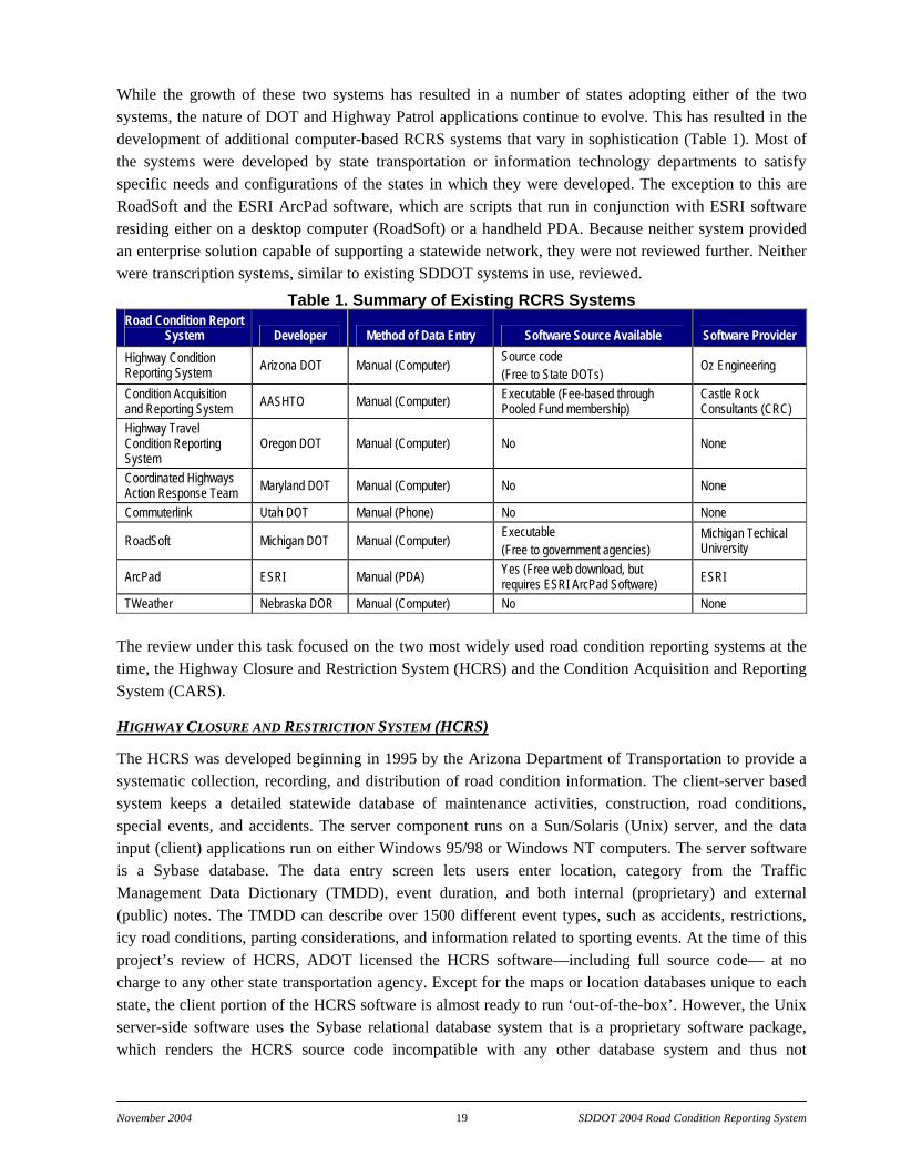
While the growth of these two systems has resulted in a number of states adopting either of the two systems, the nature of DOT and Highway Patrol applications continue to evolve. This has resulted in the development of additional computer-based RCRS systems that vary in sophistication (Table 1). Most of the systems were developed by state transportation or information technology departments to satisfy specific needs and configurations of the states in which they were developed. The exception to this are RoadSoft and the ESRI ArcPad software, which are scripts that run in conjunction with ESRI software residing either on a desktop computer (RoadSoft) or a handheld PDA. Because neither system provided an enterprise solution capable of supporting a statewide network, they were not reviewed further. Neither were transcription systems, similar to existing SDDOT systems in use, reviewed.
Table 1. Summary of Existing RCRS Systems Road Condition Report
System Developer Method of Data Entry Software Source Available Software Provider Highway Condition Reporting System Arizona DOT Manual (Computer) Source code
(Free to State DOTs) Oz Engineering
Condition Acquisition and Reporting System AASHTO Manual (Computer) Executable (Fee-based through
Pooled Fund membership) Castle Rock Consultants (CRC)
Highway Travel Condition Reporting System
Oregon DOT Manual (Computer) No None
Coordinated Highways Action Response Team Maryland DOT Manual (Computer) No None
Commuterlink Utah DOT Manual (Phone) No None
RoadSoft Michigan DOT Manual (Computer) Executable (Free to government agencies)
Michigan Techical University
ArcPad ESRI Manual (PDA) Yes (Free web download, but requires ESRI ArcPad Software) ESRI
TWeather Nebraska DOR Manual (Computer) No None The review under this task focused on the two most widely used road condition reporting systems at the time, the Highway Closure and Restriction System (HCRS) and the Condition Acquisition and Reporting System (CARS).
HIGHWAY CLOSURE AND RESTRICTION SYSTEM (HCRS)
The HCRS was developed beginning in 1995 by the Arizona Department of Transportation to provide a systematic collection, recording, and distribution of road condition information. The client-server based system keeps a detailed statewide database of maintenance activities, construction, road conditions, special events, and accidents. The server component runs on a Sun/Solaris (Unix) server, and the data input (client) applications run on either Windows 95/98 or Windows NT computers. The server software is a Sybase database. The data entry screen lets users enter location, category from the Traffic Management Data Dictionary (TMDD), event duration, and both internal (proprietary) and external (public) notes. The TMDD can describe over 1500 different event types, such as accidents, restrictions, icy road conditions, parting considerations, and information related to sporting events. At the time of this project’s review of HCRS, ADOT licensed the HCRS software—including full source code— at no charge to any other state transportation agency. Except for the maps or location databases unique to each state, the client portion of the HCRS software is almost ready to run ‘out-of-the-box’. However, the Unix server-side software uses the Sybase relational database system that is a proprietary software package, which renders the HCRS source code incompatible with any other database system and thus not

November 2004 20 SDDOT 2004 Road Condition Reporting System
compliant with the Microsoft SQL Server requirement of SDBIT. Further, the clients are custom-written Microsoft Windows applications. At the time of the review HCRS developers were working on a web-based client that would eliminate the need for the "proprietary" MS Windows-based client application.
CONDITION ACQUISITION AND REPORTING SYSTEM (CARS)
The CARS was developed beginning in 1998 as an adaptation of HCRS and a part of the FORETELL project to collect, record and disseminate road condition and incidents. Published information on CARS was not available for the UNDAF/Meridian assessment as CARS is a proprietary system of Castle Rock Consultants through a partnership under a pooled fund study agreement with the states lead by Iowa, Wisconsin, Missouri and Minnesota. Meridian’s primary experience with CARS was derived from its work with MnCARS, a Minnesota Department of Transportation (MnDOT) version of CARS, and through presentations and discussions of the system by Mr. John Whited, Iowa Department of Transportation. As with HCRS, CARS uses a client-server based system residing on a large Solaris host system with a proprietary database system. The significant difference between CARS and HCRS is that CARS supports a web-based client interface (although HCRS developers eventually completed a web-based client interface). MnCARS allows remote sites to access a central database server through Java-based client applications. Clients can both view data on a map interface and enter new road condition information
CARS is TMDD compliant and at least the MnCARS version of CARS exports data in XML format. The system application runs on a single server, taking input from all available users. The MnCARS XML output runs on a separate server, pushing data every 5 minutes to Meridian for fusion with the Road/Weather Information System (automated) data, before dissemination to the public. The MnCARS data consists of information on construction locations and restrictions, lane/road closures due to accidents and weather, maintenance activities, and other information from the State Patrol and District Offices. Along with specific staffing requirements, the Districts are instructed to update “situations” at minimum twice per day at 8:30 am and 4:30 pm, or as conditions change.
MnCARS also generates an XML file for sharing information in the MnCARS database with entities outside MnDOT’s network firewall. The XML file resides on a separate server and is currently sharing information with Castle Rock Services and with Meridian for MnDOT’s 800# (511) telephony and with Meridian’s www.safetravelusa.com Internet site.
CARS is expensive with a $10,000 fee to become a CARS user member, plus additional software maintenance fees (amount was not available) to receive software upgrades. The source code is proprietary and not available to the end user agency. Custom changes to the system require approval of the software developers and a committee composed of member state users. Special dispensation enables custom software modification, but this incurs an additional development cost and the system is not assured of being consistent with other CARS versions. Such is the case with MnCARS where MnDOT has extended customization to their version of CARS to satisfy their evolving needs.
ROAD CONDITION REPORTING SYSTEM STRENGTH/LIMITATION ASSESSMENT
The strengths and limitations of CARS and HCRS were evaluated along with a comparison of both to the original criteria provided by the Technical Panel (stakeholders). The perceived strengths and limitations of CARS are summarized in Table 2.
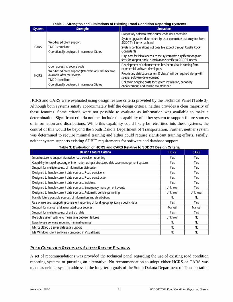
November 2004 21 SDDOT 2004 Road Condition Reporting System
Table 2: Strengths and Limitations of Existing Road Condition Reporting Systems System Strengths Limitations
CARS Web-based client support TMDD compliant Operationally deployed in numerous States
Proprietary software with source code not accessible System upgrades determined by user committee that may not have SDDOT’s interest at hand System configurations not possible except through Castle Rock Consultants High cost for initial access to the system with significant ongoing fees for support and customization specific to SDDOT needs
HCRS
Open access to source code Web-based client support (later versions that became available after the review) TMDD-compliant Operationally deployed in numerous States
Development of enhancements has been slow in coming from commercial software developers Proprietary database system (Sybase) will be required along with special software development Unknown ongoing costs for system installation, capability enhancement, and routine maintenance.
HCRS and CARS were evaluated using design feature criteria provided by the Technical Panel (Table 3). Although both systems satisfy approximately half the design criteria, neither provides a clear majority of these features. Some criteria were not possible to evaluate as information was available to make a determination. Significant criteria not met include the capability of either system to support future sources of information and distributions. While this capability could likely be retrofitted into these systems, the control of this would be beyond the South Dakota Department of Transportation. Further, neither system was determined to require minimal training and either could require significant training efforts. Finally, neither system supports existing SDBIT requirements for software and database support.
Table 3: Evaluation of HCRS and CARS Relative to SDDOT Design Criteria Design Feature Criteria HCRS CARS
Infrastructure to support statewide road condition reporting Yes Yes Capability for rapid updating of information using a structured database management system Yes Yes Support for multiple points of information distribution Yes Yes Designed to handle current data sources: Road conditions Yes Yes Designed to handle current data sources: Road construction Yes Yes Designed to handle current data sources: Incidents Yes Yes Designed to handle current data sources: Emergency management events Unknown Yes Designed to handle current data sources: Automatic vehicle permitting Unknown Unknown Handle future possible sources of information and distributions No No Use of rule sets supporting consistent reporting of local, geographically specific data Yes Yes Support for manual and automated data sources Manual Manual Support for multiple points of entry of data Yes Yes Reliable system with long mean time between failures Unknown No Easy to use software requiring minimal training No No Microsoft SQL Server database support No No MS Windows client software composed in Visual Basic No No
ROAD CONDITION REPORTING SYSTEM REVIEW FINDINGS
A set of recommendations was provided the technical panel regarding the use of existing road condition reporting systems or pursuing an alternative. No recommendation to adopt either HCRS or CARS was made as neither system addressed the long-term goals of the South Dakota Department of Transportation
November 2004 22 SDDOT 2004 Road Condition Reporting System
for a reliable and adaptable road condition reporting system and due to either their high infrastructure overhead costs or access fees. It was therefore recommended that an improved road condition reporting system be developed by Meridian for the South Dakota Department of Transportation that conformed to the design considerations expressed by the Technical Panel in the November 16, 2001 meeting. This proposed system would adhere to a fully open system design compliant with the SQL Server interface requirements expressed by the South Dakota Bureau of Information Technology and, where possible, code elements available from HCRS would be adopted. The client-side interface would be designed to support user-friendly graphical user interfaces and platform independent software to maximize application portability across computer platforms. In order to overcome issues associated with SDBIT software design standards, requirements and hosting, it was recommended that the database management system be outsourced with the resulting database interface to SDDOT coming through SDBIT network configurations via an external database hosted at Meridian. The specifics of the recommended client-server development were:
building a custom database and platform independent client data entry and manipulation system;
use of open source software and operating systems;
an SQL-compliant database;
all database access methods using database-independent access libraries, which will isolate the chosen database API and transform it into an API that is common to any database.
Specifically, the names of the various software packages recommended for incorporation were:
Host operating system: FreeBSD (www.freebsd.org)
Host database system: MySQL (www.mysql.com), libdbi (libdbi.sourceforge.net/docs)
Programming languages: C, Tcl (tcl.activestate.com)
Client hosting: via Citrix server
The hardware to host the database system was a custom-built system having the following specifications:
Host system: Intel Pentium or AMD Athlon based system
Disk: Redundant Arrays of Inexpensive Disks (RAID)
All software created (except software already in use at Meridian) was proposed to be released as open source under an appropriate general open source license.
LOGICAL / PHYSICAL ARCHITECTURE AND OPERATIONAL DATABASE STRUCTURE The logical architecture of the SDDOT RCRS consists of various processes, data flows, terminators and data stores. Criteria used to define the architecture included:
establishing a relational database for all road conditions;
conformance, to the fullest extent possible, to the Traffic Management Data Dictionary standard
geographically reference to South Dakota’s entire state highway network
November 2004 23 SDDOT 2004 Road Condition Reporting System
The architecture was to conform to the latest release of the Traffic Management Data Dictionary (TMDD) as maintained by Institute of Transportation Engineers (ITE). Specific information and electronic copies of the documents can be found online at http://www.ite.org/tmdd/ or another site that was established by the Southwest Research Institute, which calls itself the "Unofficial TMDD Web Site" at http://www.tmdd.org. Although the TMDD has yet to be adopted as a standard, due to its widespread adoption and use in several states and systems, it is rapidly becoming a de facto standard.
The TMDD was developed in parallel with the "Message Sets for External Traffic Management Center Communication" (MS/ETMCC) proposed standard. Together these two standards can be used to develop frameworks to collect, disseminate, and share road and traffic information among various agencies, and to communicate information to/from various automated devices such as dynamic message signs or automated road/weather stations (RWIS).
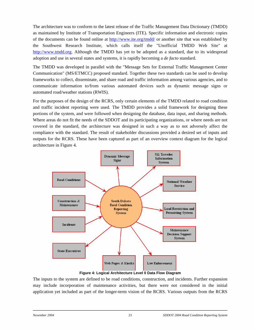
For the purposes of the design of the RCRS, only certain elements of the TMDD related to road condition and traffic incident reporting were used. The TMDD provides a solid framework for designing these portions of the system, and were followed when designing the database, data input, and sharing methods. Where areas do not fit the needs of the SDDOT and its participating organizations, or where needs are not covered in the standard, the architecture was designed in such a way as to not adversely affect the compliance with the standard. The result of stakeholder discussions provided a desired set of inputs and outputs for the RCRS. These have been captured as part of an overview context diagram for the logical architecture in Figure 4.
Figure 4: Logical Architecture Level 0 Data Flow Diagram The inputs to the system are defined to be road conditions, construction, and incidents. Further expansion may include incorporation of maintenance activities, but there were not considered in the initial application yet included as part of the longer-term vision of the RCRS. Various outputs from the RCRS
November 2004 24 SDDOT 2004 Road Condition Reporting System
are envisioned to provide the maximum level of exposure and application of the data. The structure of the architecture does not limit the final outputs to those in the context diagram. Future applications may be added to the system and must only be defined at some future time. Those items identified in the context diagram represent the anticipated end uses from stakeholder discussions.
The database schema design is the foundation of the entire system, and, required considerable care in its design. Before the database schema could be designed, many decisions about data types and data interdependencies of interest to SDDOT had to be made. The types and means of data input and dissemination influenced these decisions.
What follows is an outline of the various data elements, what sub-elements define these elements, and other issues considered before final construction of the database.
BASIC DATA TYPES AND INTERDEPENDENCIES
Road Network Definition
Since what was being designed was a road information system, it was critical to know where all the roads of statewide interest were located. The designed system assumed only routes having a reference post system (e.g. Interstate highway, US, and state routes). Information considered from the road network was:
route name, number, type;
reference post coordinates (latitude/longitude or state plane);
locations of various features (intersections and cities and towns);
number of lanes and starting and ending coordinates of changes;
agency(ies) responsible for maintenance.
The more information available regarding the road network in the database, the greater the flexibility available to the user in specifying and manipulating the road condition information. Care was taken in designing the schema to handle an extremely detailed dataset that does not have to be fully populated to be useful.
Incident and Condition Definition
Incident and condition types are covered well by the TMDD. However, conditions that are generally reported by SD law enforcement (such as “THAW-DRIFT-STICK”) are not specifically included in the TMDD (see discussion on SDLETS below). The TMDD also covers situations that do not apply in South Dakota because of the rural nature of most of the road network. For example, ramp metering and many other traffic congestion issues not encountered.
Generally, the TMDD covered the gamut of conditions and incidents, so modifications were not required to the TMDD for the RCRS. All conditions covered by the TMDD relevant to South Dakota were used, while those conditions not pertinent to South Dakota were blocked omitted.
Location Definition
The specification of a location of a particular incident or condition is particularly important to the traveling motorist. From a technical standpoint, the specification of locations by reference post is the

November 2004 25 SDDOT 2004 Road Condition Reporting System
easiest method to implement. However, from a motorist's viewpoint, even well traveled motorists can have difficulty in determining exactly where a particular location is when given by a mile marker. The situation is compounded if that person is receiving the information at home as part of a pre-travel activity. Having the ability to relate this information to known landmarks such as major cities/towns or intersections improves the usability of the RCRS data.
This situation isn't limited to the end user. If a dispatcher receives information regarding an incident "five miles west of Whoville on route 3", having the ability to enter the information in that fashion will greatly improve usability of the system and timeliness of data throughput. The situation of having a report of a major chemical spill delayed for twenty minutes because the dispatcher had to figure out what mile marker to enter had to be avoided. The capabilities provided in the database schema were governed to a large extent by the road network definition.
Having the ability to assign road conditions to segments of roads based on a geographical area (e.g. a county) instead of by a physical selection of each road in that area was desirable in the design. This is particularly useful in situations of “severe” clear weather when the roads are bare and dry, the winds are light, and visibility is unlimited for transportation. There are situations, though, where selecting broad areas for which to assign conditions can be misleading or incorrect. Such situations were encountered during a test situation in late February 2002 where a fairly large area of snow moved through central Minnesota. Cass County, Minnesota geographically has a large north-south extent and because of its size and the variations in weather conditions had approximately 80% coverage of snowfall. Minnesota DOT reported this county as having “difficult driving conditions” and did not have a separate report for any highway in that county. U.S. Highway 2 runs on the extreme far north end of the county where no snow was falling yet a strong snow storm existed across much of the county. The conditions for U.S. Highway 2 was bare and dry and visibility was greater than 10 miles, but the road report stated “difficult driving conditions.”
Another general example particular to South Dakota involves situations where certain weather phenomena are occurring at different elevations ("snow above 3000 feet") which is a problem encountered in the Black Hills area. The TMDD makes provisions for this and the logical architecture so incorporates this feature.
Time, Duration, and Recurrence Definition
These elements were straightforward to identify for the database schema. These elements generally divided into two types: conditions that exist for a continuous period of time (such as wet roads) and conditions which exist for intermittent periods (such as road maintenance that happens after 5PM each weekday). Further, most incident or condition reports have a start time, an end time, and a recurrence character (which may be “continuous”). The database schema fully supports this type of reporting.
Often there are situations where a particular incident has no easily determined end time. In such situations, provisions are made for an “until further notice” specification. However, such cases must be handled carefully. Situations were identified where a condition of morning fog has been reported on a Friday morning with an end time of “until further notice.” In this case, the situation was not amended by the reporting agency and remained in the system until it was discovered the following Monday. Thus, fog was reported for the entire weekend. While it may be possible to flag these errors in the system through a correlation with observed weather from the SDDOT weather service provider, the modification of the
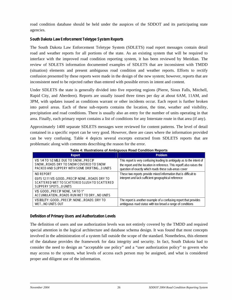
November 2004 26 SDDOT 2004 Road Condition Reporting System
road condition database should be held under the auspices of the SDDOT and its participating state agencies.
South Dakota Law Enforcement Teletype System Reports
The South Dakota Law Enforcement Teletype System (SDLETS) road report messages contain detail road and weather reports for all portions of the state. As an existing system that will be required to interface with the improved road condition reporting system, it has been reviewed by Meridian. The review of SDLETS information documented examples of SDLETS that are inconsistent with TMDD (situation) elements and present ambiguous road condition and weather reports. Efforts to rectify confusion presented by these reports were made in the design of the new system; however, reports that are inconsistent need to be rejected rather than entered with possible errors in intent and content.
Under SDLETS the state is generally divided into five reporting regions (Pierre, Sioux Falls, Mitchell, Rapid City, and Aberdeen). Reports are usually issued three times per day at about 6AM, 11AM, and 3PM, with updates issued as conditions warrant or other incidents occur. Each report is further broken into patrol areas. Each of these sub-reports contains the location, the time, weather and visibility, precipitation and road conditions. There is usually also an entry for the number of units operating in that area. Finally, each primary report contains a list of conditions for any Interstate route in that area (if any).
Approximately 1400 separate SDLETS messages were reviewed for content patterns. The level of detail contained in a specific report can be very good. However, there are cases where the information provided can be very confusing. Table 4 depicts several excerpts extracted from SDLETS reports that are problematic along with comments describing the reason for the error.
Table 4: Illustrations of Ambiguous Road Condition Reports Report Problem
VIS 1/4 TO 1/2 MILE DUE TO SNOW...PRECIP SNOW...ROADS DRY TO SNOW COVERED TO SNOW PACKED AND SLIPPERY WITH SOME DRIFTING...3 UNITS
This report is very confusing leading to ambiguity as to the intent of the report and the location in reference. This report also raises the question of exactly which roads these sub-areas cover
NO REPORT 03/15 12:11 VIS GOOD...PRECIP NONE...ROADS DRY TO SCATTERED WET TO SCATTERED SLUSH TO SCATTERED SLIPPERY SPOTS...0 UNITS VIS GOOD...PRECIP NONE, 1/4 TO 1" ACCUMULATION...ROADS RUN WET TO DRY...NO UNITS
These two reports provide mixed information that is difficult to interpret and lack sufficient geographical reference
VISIBILITY: GOOD...PRECIP: NONE...ROADS: DRY TO WET...NO UNITS OUT
The report is another example of a confusing report that provides ambiguous road status with too broad a range of conditions
Definition of Primary Users and Authorization Levels
The definition of users and use authorization levels was not entirely covered by the TMDD and required special attention in the logical architecture and database schema design. It was found that most concepts involved in the administration of a system fall outside the scope of the standard. Nonetheless, this element of the database provides the framework for data integrity and security. In fact, South Dakota had to consider the need to design an “acceptable use policy” and a “user authorization policy” to govern who may access to the system, what levels of access each person may be assigned, and what is considered proper and diligent use of the information.

November 2004 27 SDDOT 2004 Road Condition Reporting System
Interagency cooperation also falls into this area. One example of how this comes into play is a situation where law enforcement enters a particular element of information. Does an individual from a different agency have permission to modify that information? Again, the system was designed to handle such interagency restrictions or permissions; however, the levels of these safeguards or limits were an important design challenge of the project.
ROAD CONDITION REPORTING SYSTEM DATABASE SCHEMA
The road condition reporting system database was designed to contain a current and historical record of road network situations or occurrences. The four types of episodes included within the database were:
incident (such as a traffic accident),
event (such as scheduled road construction),
condition (such as blowing snow), and
forecast condition (such as pavement temperature).
An episode is described by location, date/time, description, and imposed dimension limits. Other information such as user name and free text comments are included for administrative purposes.
The database tables are not designed to contain detailed information on the geographical nature of the road network. The road network details were left to the client program that manipulates the database. The database only understands route names and linear referencing along these routes.
The database is divided into four general areas:
the Traffic Management Data Dictionary (TMDD) tables;
the road network tables;
the user tables;
the occurrence report tables.
The extension of the road conditions reporting system context diagram results in the level zero data flow diagram in Figure 5. The level zero data flow describes the logical architecture that considers the various episode/process types and general database areas within the RCRS.
The data flow diagram depicts six data stores that constitute the framework of stored data within the road condition reporting system. Much of the data resides as static or seldom changed data supporting the dynamic road condition, construction and incident data that provide the core of the RCRS. Each data store constitutes a series of database schemas that were defined and developed to support the RCRS. The function and structure of each are described below. Detailed descriptions of all database tables are included in Appendix A—Data Tables.
The relational database is built following the entity relationship diagram in Figure 6. The associated data stores are maintained on an operational installed at Meridian Environmental Technology as directed by SDDOT personnel.
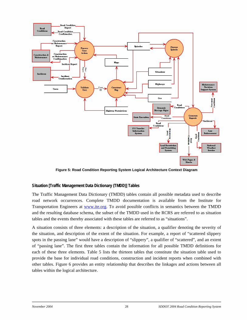
November 2004 28 SDDOT 2004 Road Condition Reporting System
Figure 5: Road Condition Reporting System Logical Architecture Context Diagram
Situation [Traffic Management Data Dictionary (TMDD)] Tables
The Traffic Management Data Dictionary (TMDD) tables contain all possible metadata used to describe road network occurrences. Complete TMDD documentation is available from the Institute for Transportation Engineers at www.ite.org. To avoid possible conflicts in semantics between the TMDD and the resulting database schema, the subset of the TMDD used in the RCRS are referred to as situation tables and the events thereby associated with these tables are referred to as “situations”.
A situation consists of three elements: a description of the situation, a qualifier denoting the severity of the situation, and description of the extent of the situation. For example, a report of “scattered slippery spots in the passing lane” would have a description of “slippery”, a qualifier of “scattered”, and an extent of “passing lane”. The first three tables contain the information for all possible TMDD definitions for each of these three elements. Table 5 lists the thirteen tables that constitute the situation table used to provide the base for individual road conditions, construction and incident reports when combined with other tables. Figure 6 provides an entity relationship that describes the linkages and actions between all tables within the logical architecture.

November 2004 29 SDDOT 2004 Road Condition Reporting System
Table 5: Situation [Traffic Management Data Dictionary] Tables Table Name Function
situation_categories Defines all the categories of situations situation_descriptions Contains all pertinent elements of the condition reporting data dictionary
situation_description_categories Defines relationship between categories and descriptions. Descriptions have a primary category and can belong to other categories as well
situation_qualifiers Contains all pertinent description qualifiers situation_extents Contains all pertinent description* extents situation_description_extents Defines relationship between descriptions and extents situation_description_qualifiers Defines relationship between descriptions and qualifiers situation_enum_members Contains all pertinent description enumeration members situation_enums Defines relationship between descriptions and enumeration members situation_description_info Contains ancillary information about situation descriptions (default values, etc)
situation_templates Defines names for situation templates. A template contains a collection of user-reportable situation descriptions
situation_template_users Defines relationships between users and situation templates situation_template_descriptions Defines which situation descriptions are in each template
The tables describe the possible relationships between the descriptions and qualifiers and the descriptions and extents. For example, it is not reasonable to say "scattered road construction". These tables allow client programs to determine the generally accepted combinations of descriptions, qualifiers, and extents.
Road Network Tables
The database does not contain support for storing detailed geographic locations of all elements of the road network. Instead, it leaves the details to the client programs. The database itself only enforces a standardized method of reporting the name of a route. A route name consists of three pieces: country/state, type, and designation. For example, Interstate 90 in Sioux Falls has the following components: “South Dakota (US)”, “Interstate”, and “90”. Other methods of road naming are taken into account through the use of an alias table, which cross-references an alias designation with the database definition. Table 6 provides a summary of the road network tables.
Table 6: Road Network Tables
Table Name Function highways Contains basic information for each signed route in the road network highway_links Contains information for each highway “link” A link is the smallest reportable segment of highway highway_domain_types Defines types of administrative areas of highway maintenance responsibilities highway_domains Contains administrative areas of highway maintenance responsibilities highway_link_domains Contains relationships between highway links and the domains of which they are members highway_permissions Defines relationships between user and highway domains (for defining reporting area permissions)
Geography Tables
All data found within the RCRS depends upon a geographical reference to be referenced to the client application interface. The geography tables (Table 7) provide the geographical reference for each geographical attribute.

November 2004 30 SDDOT 2004 Road Condition Reporting System
Table 7: Geography Tables Table Name Function
geo_countries Contains codes, abbreviations, and names for all countries geo_states Contains codes, abbreviations, and names for all states (United States, for now)
User Administration Tables
The user administration tables (Table 8) are used to track all users of the system. A user is defined as anyone or anything that reads, inserts, or manipulates the information in the database. A user can be a snow plow driver, a highway patrol dispatcher, highway engineer, etc. A user can also be a software program created to extract and/or manipulate the data for external uses (such as 511, automated permitting system, etc.).
Table 8: User Administration Tables
Table Name Function users Contains information for each user of the system user_aliases Contains information on user aliases (used for special authentication) agency_ip_addresses Contains IP address patterns of agency client computers (used for special authentication)
The tables also support the concept of reliability. This is especially important when allowing RWIS stations to automatically enter observations. Communications, sensor, or other hardware problems may degrade the quality of an RWIS observation. The user reliability table allows for the tracking of quality control statistics.
Episode Report Tables
The final table (Table 9) category in the logical architecture contains the detailed information for each episode specific during data entry. If more than one episode is happening at a given location (such as “drifting snow”, “snow-packed”, and “slippery”), then each occurrence is entered separately. Some episodes can have physical values associated with them (such as visibility).
The episode tables describe the actual occurrence itself (location, start/end date/time, recurring times (if any), description, public accessibility, and free-text comments. Also, the episode tables track occurrences of situation evolution and other administrative information. The “comments” field in each table is present for distinct purposes. The occurrence comments are for free-text comments pertaining strictly to the occurrence itself (answers questions such as “what is the road construction for?”). The history comments are for free-text comments pertaining strictly to the administrative details of the history of the episode (answers questions such as “why was it changed?”). In both cases the comments are not meant for public consumption. They are there to convey information to different state agencies regarding the administrative details of the occurrence. However, while this feature has been designed into the database schema, no means exist at present to input comments.
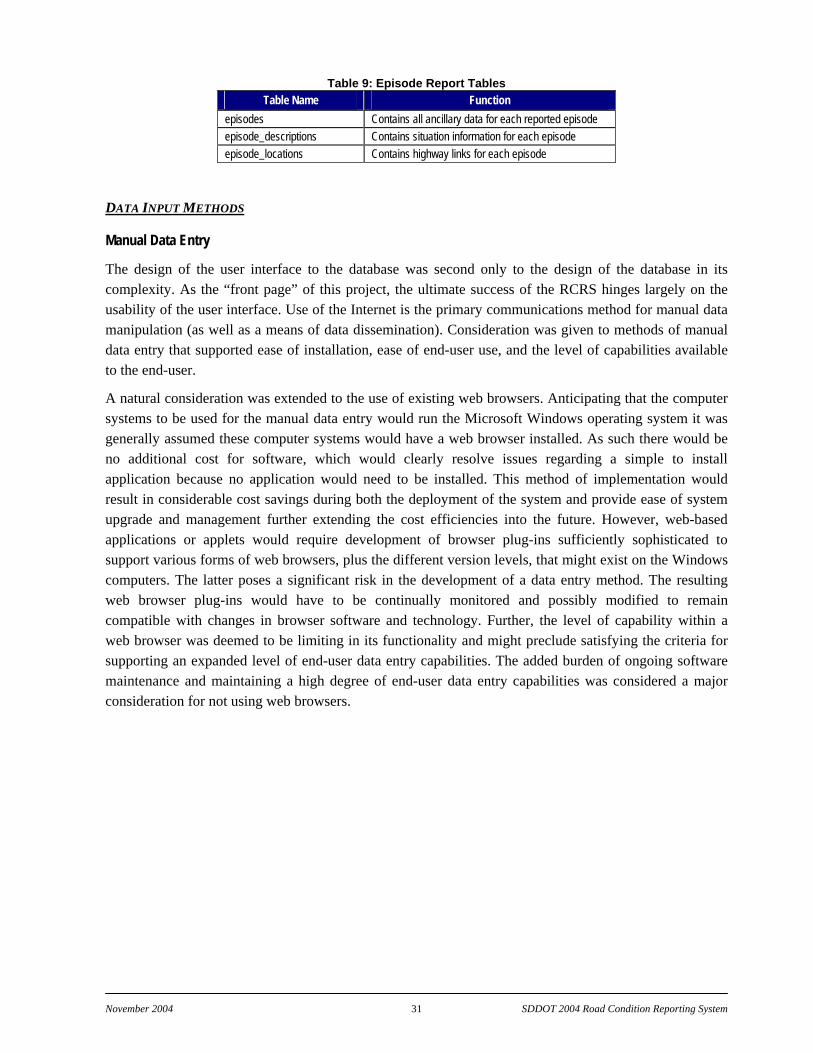
November 2004 31 SDDOT 2004 Road Condition Reporting System
Table 9: Episode Report Tables Table Name Function
episodes Contains all ancillary data for each reported episode episode_descriptions Contains situation information for each episode episode_locations Contains highway links for each episode
DATA INPUT METHODS
Manual Data Entry
The design of the user interface to the database was second only to the design of the database in its complexity. As the “front page” of this project, the ultimate success of the RCRS hinges largely on the usability of the user interface. Use of the Internet is the primary communications method for manual data manipulation (as well as a means of data dissemination). Consideration was given to methods of manual data entry that supported ease of installation, ease of end-user use, and the level of capabilities available to the end-user.
A natural consideration was extended to the use of existing web browsers. Anticipating that the computer systems to be used for the manual data entry would run the Microsoft Windows operating system it was generally assumed these computer systems would have a web browser installed. As such there would be no additional cost for software, which would clearly resolve issues regarding a simple to install application because no application would need to be installed. This method of implementation would result in considerable cost savings during both the deployment of the system and provide ease of system upgrade and management further extending the cost efficiencies into the future. However, web-based applications or applets would require development of browser plug-ins sufficiently sophisticated to support various forms of web browsers, plus the different version levels, that might exist on the Windows computers. The latter poses a significant risk in the development of a data entry method. The resulting web browser plug-ins would have to be continually monitored and possibly modified to remain compatible with changes in browser software and technology. Further, the level of capability within a web browser was deemed to be limiting in its functionality and might preclude satisfying the criteria for supporting an expanded level of end-user data entry capabilities. The added burden of ongoing software maintenance and maintaining a high degree of end-user data entry capabilities was considered a major consideration for not using web browsers.
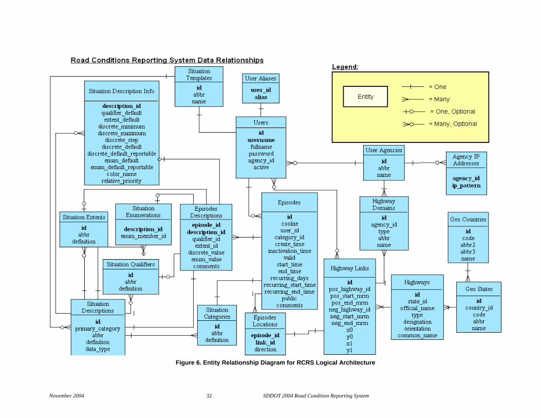
November 2004 32 SDDOT 2004 Road Condition Reporting System
Figure 6. Entity Relationship Diagram for RCRS Logical Architecture
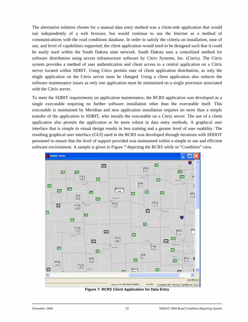
November 2004 33 SDDOT 2004 Road Condition Reporting System
The alternative solution chosen for a manual data entry method was a client-side application that would run independently of a web browser, but would continue to use the Internet as a method of communications with the road conditions database. In order to satisfy the criteria on installation, ease of use, and level of capabilities supported, the client application would need to be designed such that it could be easily used within the South Dakota state network. South Dakota uses a centralized method for software distribution using access infrastructure software by Citrix Systems, Inc. (Citrix). The Citrix system provides a method of user authentication and client access to a central application on a Citrix server located within SDBIT. Using Citrix permits ease of client application distribution, as only the single application on the Citrix server must be changed. Using a client application also reduces the software maintenance issues as only one application must be maintained on a single processor associated with the Citrix server.
To meet the SDBIT requirements on application maintenance, the RCRS application was developed as a single executable requiring no further software installation other than the executable itself. This executable is maintained by Meridian and new application installation requires no more than a simple transfer of the application to SDBIT, who installs the executable on a Citrix server. The use of a client application also permits the application to be more robust in data entry methods. A graphical user interface that is simple in visual design results in less training and a greater level of user usability. The resulting graphical user interface (GUI) used in the RCRS was developed through iterations with SDDOT personnel to ensure that the level of support provided was maintained within a simple to use and efficient software environment. A sample is given in Figure 7 depicting the RCRS while in “Condition” view.
Figure 7: RCRS Client Application for Data Entry

November 2004 34 SDDOT 2004 Road Condition Reporting System
From the authentication information found within the map database for a user, the GUI launches with a predetermined, user-specific location of South Dakota in the display field of view. This permits a more rapid start for data entry by reducing the need to pan or zoom to a user’s area of action. The generation of the road network display including attributes of maintenance areas, units, and shops is accomplished through database calls to the map database associated with the RCRS.
Table 10: Distribution of Authentication Levels for RCRS Data Entry User Statewide View Area View Unit View
Operations Support Staff Yes Yes Yes Region Engineers Yes Yes Yes Area Engineers No Yes Yes Area Engineering Supervisors No Yes No Highway Maintenance Supervisors No No Yes Lead Highway Maintenance Supervisors No No Yes
Table 11: Map Display Tables Table Name Function
maps Defines base map characteristics for each map drawable by the client application GUI map_icon_types Defines map icon types. map_icons Defines map icons. map_icon_coordinates Defines relationships between map icons and base maps including information on coordinates
After the RCRS Citrix application has been launched, the user has the ability of viewing and/or modifying information through interaction with the GUI either using mouse movements/buttons click and/or key stroke combinations. The level of interaction was designed to provide the maximum flexibility possible while keeping the activities focused to a specific short set of user functions. The interactive functions with the main graphics window include five operations to select editable features. The methods permitted to define the location of an operation in the RCRS include:
By Area—Initiated by clicking on an Area Box that selects all road segments belonging to that Area;
By Unit—Initiated by clicking on a Unit Box that selects all road segments belonging to a Unit;
By Shop—Initiated by clicking on a Shop Box that selects all road segments belonging to a Shop;
By Individual Road Segment—Initiated by clicking on a point on a highway selects a single road segment corresponding to a winter maintenance route; and
By Highway—Initiated by clicking on a highway number shield that selects all of a highway located within the user’s realm of authority.
The data input capabilities have been optimized to minimize the number of user input operations needed to define the road condition, incident and/or construction information. Dialog boxes used to enter road condition information (Figure 8) provide information from the selection process to confirm the locations selected in addition to the user input operations. The inputs are specified using drop down list boxes as the principal selection method. These list boxes are populated with selections found within the database and address the conditions identified in the design process as applicable to South Dakota. In addition to the list boxes, checkboxes are used where the number of selection categories is limited.
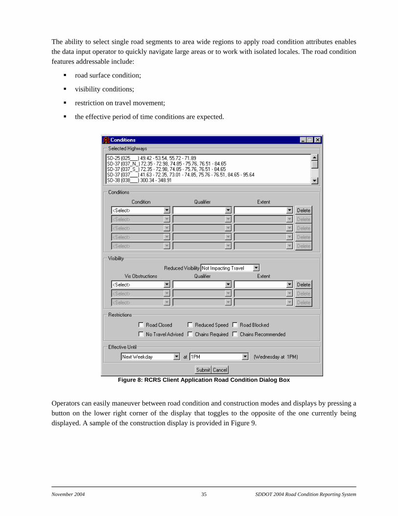
November 2004 35 SDDOT 2004 Road Condition Reporting System
The ability to select single road segments to area wide regions to apply road condition attributes enables the data input operator to quickly navigate large areas or to work with isolated locales. The road condition features addressable include:
road surface condition;
visibility conditions;
restriction on travel movement;
the effective period of time conditions are expected.
Figure 8: RCRS Client Application Road Condition Dialog Box
Operators can easily maneuver between road condition and construction modes and displays by pressing a button on the lower right corner of the display that toggles to the opposite of the one currently being displayed. A sample of the construction display is provided in Figure 9.

November 2004 36 SDDOT 2004 Road Condition Reporting System
Figure 9: RCRS Client Application Construction Interface
Figure 10:RCRS Client Application Construction Dialog Box
November 2004 37 SDDOT 2004 Road Condition Reporting System
The road construction and maintenance conditions input dialog (Figure 10) permits the input operator to address construction project information that includes:
specification of construction highway and location;
description of construction and maintenance activity;
restrictions on travel expect within the construction area,
start date and time;
recurrence period of construction if applicable.
A primer on the use of the RCRS data input interface has been developed by Mr. David Huft, Research Engineer, South Dakota DOT and is presently in use by the SDDOT for training purposes. This primer provides detailed description of the input operations that would be encountered in a typical data entry session.
Automated data entry from electronically available external sources
In addition to the manual entry of data from a desktop computer, the SDDOT has a strong desire to develop methods that permit remote manual data entry and automated data entry. Methods of remote data entry (possibly using state radio or digital cellular phones) were tentatively explored during this project as part of several project tasks. However, complications encountered in the design, development and population of the RCRS database precluded a more detailed review and testing of these methods. Further, the ongoing development of a State infrastructure to permit digital radio capabilities did not proceed to a level that permitted full design of plans for testing. Meridian did investigate database requirements to support the remote entry and the final database design is well suited to support such activities. However, to accomplish the remote data entry, a well-defined database API and the use of different modules to handle data from different media will be required. The following summarizes the efforts completed to consider remote and/or automated data entry to the RCRS.
There are several sources from which automated, electronic information can be derived and offered as input to the database. These include: National Weather Service watches, warning, advisories; NWS/FAA/RWIS weather observations; NWS weather radar; and NWS weather satellite imagery. The design of the remote and automated data entry system should be such that as new data sources become available, and subject to their availability in a consistent digital form, they can be easily added as candidate inputs to the database.
South Dakota has the option of adding any or all of these depending on the derived utility of their input. For example, if it can be deduced with greater that 90% certainty that there is rain over a specific area from meteorological means, then adding data to the RCRS to indicate that the roads are wet could be accomplished automatically. Or if the satellite imagery indicates clouds over an area, the sky condition and possibly the visibility could be specified within the database. The only drawback is if the level of certainty of whether a particular phenomenon is occurring is not met, then it is important to not include anything about occurrence or lack of occurrence. Needless to say, the level of sophistication can range from very simple to very complex.
Data input directly from maintenance vehicles or other in situ road condition reporting systems parallels that mentioned for weather data inputs. Given a system with adequate operational reliability and a
November 2004 38 SDDOT 2004 Road Condition Reporting System
consistent, defined format, this information can be automatically added to the database. This includes the ability of using low-speed data transmissions over State Radio.
At present some State DOTs are experimenting with mobile maintenance reporting systems in an attempt to automate reporting methods. The Minnesota DOT Safety with Automatic Intelligent Locator (SAIL) has been exploring since 2000 the use of Automatic Vehicle Location (AVL) to collect maintenance activity information to increase maintenance effectiveness. Efforts such as SAIL and others that are incorporating wireless communication from vehicles equipped with AVL based on global positioning technology provide strong indications that the next generation of road condition and incident reporting will be automated.
OUTPUT METHODS
DEFINITION OF END-USER (CUSTOMER) PRODUCTS
Output processes were developed to feed information from the RCRS database to various output channels. From stakeholder meetings during RCRS development, the following primary types of end-user products were identified for development:
printed road condition reports;
fax and email delivered reports;
web-delivered maps and text; and
computer telephony.
All of these are automatically generated as well as created on demand by an authorized user. The present distribution channels include:
SD 511 Traveler Information System
regional road condition summaries distributed to
a) National Weather Service
b) Meridian-managed email list (approx 150 members)
c) National Law Enforcement Teletype System
d) SDDOT web site
Automated Commercial Vehicle Permitting System.
These processes permit the rapid dissemination of RCRS information to promote public benefit and safety. The resulting information is a tremendous enhancement to the spatial and temporal coverage over previous methods. A link to SafeTravelUSA, a Meridian Environmental Technology web site that presents regional road conditions, is under development. Additional end-user products can be generated and are only limited by the connection to the database server and configuration of the output to meet the requirements of the dissemination method. This includes the future adaptation of the system to the current teletype system in use by South Dakota State Radio.

November 2004 39 SDDOT 2004 Road Condition Reporting System
MEANS OF DISSEMINATION
The database has the capability of disseminating information in a variety of ways. Some of these are: web, email, xml, pager, fax, printer, and ftp. All of these methods can be generated on demand, at preset intervals or automatically. Specific dissemination procedures are described below.
South Dakota 511 Traveler Information System
The mechanisms for marshaling the RCRS data to the Traveler Information System are a part of a multi-state service that integrates databases of site-specific road weather and road condition data for delivery via the computer telephony systems of Meridian Environmental Technology. In this system mechanisms are in place to poll the RCRS database every few minutes. If changes are detected, then 511 audio messages are updated to reflect those changes. The South Dakota 511 system, as part of a multi-state system, does not operate on a per-state basis, rather as a component of the entire system. This results in many variables, timers, and events that influence the updating of phrase data and the distribution of changes to each component of the computer telephony system.
Region and state-wide text reports
Once an hour, a process generates a text summary report of current road conditions. There are seven separate reports created: northwest region, north-central region, northeast region, southwest region, south-central region, southeast region, and statewide. Each of the six region reports slightly overlap in their geographic boundaries so as to not cause interpretation problems for users. The statewide report contains the same information as the six region reports with one addition, there are detailed reports for five major east-west and five major north-south routes.
The generated reports are sent to the SDDOT FTP site and to the NWS FTP site. The copies sent to the SDDOT FTP site are distributed to both NLETS and the SDDOT web page. The copy sent to the NWS is injected to the NWS data feeds (FOS, NOAAPORT, etc.).
Meridian also maintains an email list ([email protected]) for email distribution of the statewide report to interested people. Statewide reports sent to this list follow a schedule: 7 AM, 11 AM, and 4 PM daily. Reports are also sent if there has been a change since the last report was sent to the list. There are no fewer than three and no more than twenty-four reports sent daily. Figure 11 is a partial report for the statewide road conditions. The actual report spans multiple pages (8 pages), but has been shortened for convenience in this report.
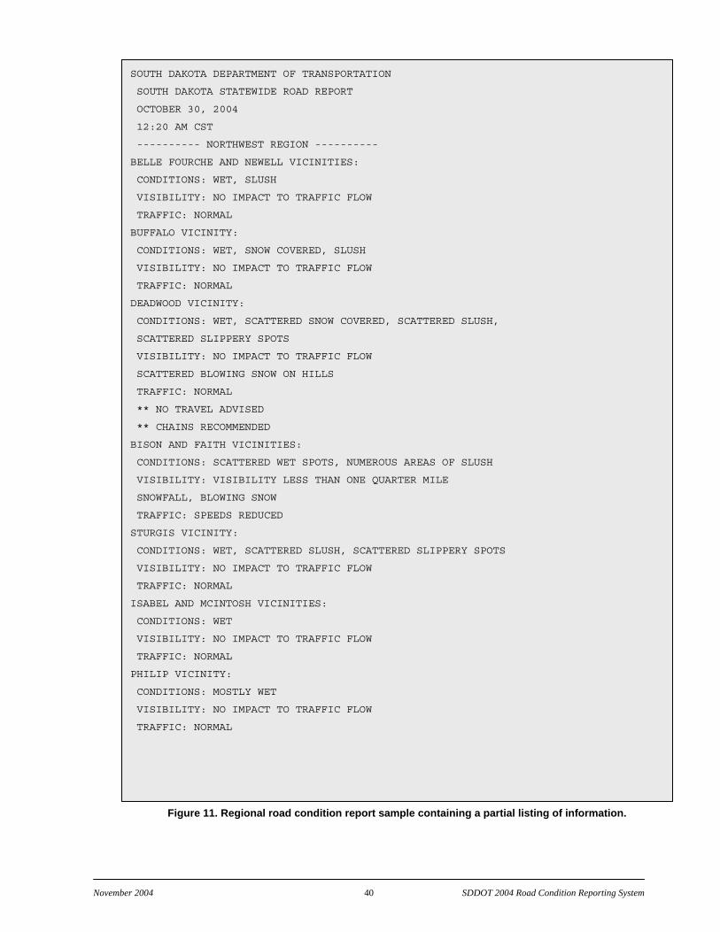
November 2004 40 SDDOT 2004 Road Condition Reporting System
SOUTH DAKOTA DEPARTMENT OF TRANSPORTATION
SOUTH DAKOTA STATEWIDE ROAD REPORT
OCTOBER 30, 2004
12:20 AM CST
---------- NORTHWEST REGION ----------
BELLE FOURCHE AND NEWELL VICINITIES:
CONDITIONS: WET, SLUSH
VISIBILITY: NO IMPACT TO TRAFFIC FLOW
TRAFFIC: NORMAL
BUFFALO VICINITY:
CONDITIONS: WET, SNOW COVERED, SLUSH
VISIBILITY: NO IMPACT TO TRAFFIC FLOW
TRAFFIC: NORMAL
DEADWOOD VICINITY:
CONDITIONS: WET, SCATTERED SNOW COVERED, SCATTERED SLUSH,
SCATTERED SLIPPERY SPOTS
VISIBILITY: NO IMPACT TO TRAFFIC FLOW
SCATTERED BLOWING SNOW ON HILLS
TRAFFIC: NORMAL
** NO TRAVEL ADVISED
** CHAINS RECOMMENDED
BISON AND FAITH VICINITIES:
CONDITIONS: SCATTERED WET SPOTS, NUMEROUS AREAS OF SLUSH
VISIBILITY: VISIBILITY LESS THAN ONE QUARTER MILE
SNOWFALL, BLOWING SNOW
TRAFFIC: SPEEDS REDUCED
STURGIS VICINITY:
CONDITIONS: WET, SCATTERED SLUSH, SCATTERED SLIPPERY SPOTS
VISIBILITY: NO IMPACT TO TRAFFIC FLOW
TRAFFIC: NORMAL
ISABEL AND MCINTOSH VICINITIES:
CONDITIONS: WET
VISIBILITY: NO IMPACT TO TRAFFIC FLOW
TRAFFIC: NORMAL
PHILIP VICINITY:
CONDITIONS: MOSTLY WET
VISIBILITY: NO IMPACT TO TRAFFIC FLOW
TRAFFIC: NORMAL
Figure 11. Regional road condition report sample containing a partial listing of information.

November 2004 41 SDDOT 2004 Road Condition Reporting System
Automated Permitting System
Every five minutes, a process polls the RCRS database and generates a custom-designed report for the Automated Permitting System. The report is in comma-separated value (CSV) format with the fields shown in Table 12.
Table 12: Fields Communicated to the Automated Permitting System
Field Content occurrence id a unique identifier used to tie multiple entries to one occurrence highway official (SDDOT) designation of the highway orientation orientation of the highway (EW or NS) highway type type of highway (I == Interstate, U = US Highway, S = State Highway) highway designation number shown on sign highway common name a common name (public name) con dition reported condition value related value (blank if not applicable) qualifier condition qualifier (blank if not applicable) extent condition extent (blank if not applicable) start mrm start MRM start mrm displacement linear distance from start MRM end mrm end MRM end mrm displacement linear distance from end MRM direction travel lanes affected
1 = direction of increasing MRMs, -1 = direction of decreasing MRMs, 0 = both directions
start date/time self-explanatory end date/time self-explanatory
The fields shown in Table 13 allow for reporting of recurring events (such as road construction occurring from 7 PM to 5 AM on Monday through Thursday). If the event does not have a recurring nature, then the start time is always 12:00:00 AM and the end time is always 11:59:59 PM.
Table 13: Fields Used to Identify Recurrent Event Times Fields
Sunday recurring start time Sunday recurring end time Monday recurring start time Monday recurring end time Tuesday recurring start time Tuesday recurring end time Wednesday recurring start time Wednesday recurring end time Thursday recurring start time Thursday recurring end time Friday recurring start time Friday recurring end time Saturday recurring start time Saturday recurring end time
Table 14 summarizes the categories of reportable information available within the Automated Permitting System.
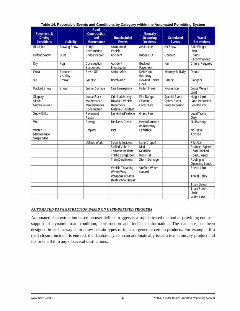
November 2004 42 SDDOT 2004 Road Condition Reporting System
Table 14. Reportable Events and Conditions by Category within the Automated Permitting System
Pavement & Driving
Conditions Visibility
Road Construction
and Maintenance
Unscheduled Events
Naturally Occurring Incidents
Scheduled Events
Travel Restrictions
Black Ice Blowing Snow Bridge Construction
Abandoned Vehicle
Avalanche Air Show Axle Weight Limit
Drifting Snow Dust Bridge Repair Accident Bridge Out Concert Chains Recommended
Dry Fog Construction Suspended
Accident Investigation
Buckled Pavement
Fair Chains Required
Frost Reduced Visibility
Fresh Oil Amber Alert Debris on Roadway
Motorcycle Rally Detour
Ice Smoke Grading Bomb Alert Downed Power Lines
Parade Flaggers
Packed Snow Snow Gravel Surface Civil Emergency Fallen Trees Procession Gross Weight Limit
Slippery Loose Rock Criminal Activity Fire Danger Special Event Height Limit Slush Maintenance Disabled Vehicle Flooding Sports Event Lane Reduction Snow Covered Miscellaneous
Construction Hazardous Materials Incident
Forest Fire State Occasion Length Limit
Snow Drifts Pavement Repair
Jackknifed Vehicle Grass Fire Local Traffic Only
Wet Paving Reckless Driver Herd of animals on Roadway
No Passing
Winter Maintenance Suspended
Striping Riot Landslide No Travel Advised
Utilities Work Security Incident Lane Dropoff Pilot Car Stalled Vehicle Mud Reduced Speed Terrorist Incident Mudslide Road Blocked Traffic Congestion Rock Fall Road Closed Train Derailment Storm Damage Routing to
Opposing Lanes Vehicle Traveling
Wrong Way Surface Water Hazard
Speed Limit
Weapons of Mass Destruction Threat
Travel Delay
Truck Detour Truck Speed
Limit Width Limit
AUTOMATED DATA EXTRACTION BASED ON USER-DEFINED TRIGGERS
Automated data extraction based on user-defined triggers is a sophisticated method of providing end user support of dynamic road condition, construction and incident information. The database has been designed in such a way as to allow certain types of input to generate certain products. For example, if a road closure incident is entered, the database system can automatically issue a text summary product and fax or email it to any of several destinations.

November 2004 43 SDDOT 2004 Road Condition Reporting System
CONCLUSIONS
The Road Condition Reporting System project provided for a sophisticated, state-of-the-art method of collecting and disseminating road conditions, construction and incident information in a more timely and spatially appropriate manner. The results of the work yielded an operational system that will promote improved safety for travelers and promote a better exchange of information to the public in general. The project was initially projected to be completed in one year. However, the complexity of designing a system that would accommodate current and future data sources required considerable interaction with SDDOT personnel and vision as to how a database could be extensible to handle next generation data input and output. In addition, the level of database preparation and population was beyond the original expected levels. This was particularly true with regards to the South Dakota digital road network database where discrepancies in the geospatial data did not permit direct incorporation within the RCRS database. Considerable effort was required to resolve these discrepancies, which significantly delayed the project completion. However, the resulting road network GIS is not only an excellent addition to the RCRS, it has provided a benefit to the SDDOT in general.
Several summary conclusions from the project include:
The generation of information with high spatial and temporal resolution requires special attention to details within the database design and high quality geospatial and attribute data to populate the dataset.
A well designed data entry methodology and associated graphical user interface are crucial to the acceptance of an application that involves a high degree of user interaction. While the database design will determine the extensibility of the information to end users of the system, having a method of input that facilitates user acceptance will largely determine whether the resulting system will be given the opportunity to succeed.
The successful completion of a project of this nature requires the commitment of a broad range of stakeholders all dedicated to maintaining a high degree of quality and end user support. To this end this project had such commitment from all participants and the resulting product should provide years of benefit to South Dakota.

November 2004 44 SDDOT 2004 Road Condition Reporting System
RECOMMENDATIONS
The further growth of information systems supporting improved information regarding the current state of the road network will be needed to keep pace with the demands of travelers and technologies that can use the information to further surface transportation products and services. The scale of information will continue to grow finer in time and space. This demand has already outpaced the capabilities of most States to manually produce the information to support these systems. Hence, it is recommended that the following efforts be considered for enhancing the work provided within this project.
Recommendation 1:The South Dakota Department of Transportation should pursue development of automated and semi-automated road condition reporting methods.
An expansion in the volume of road condition information will require both the time of field personnel and data entry personnel to support the use of the data within a road condition system unless improved methods are developed to more effectively incorporate these data within the RCRS. This can be done in two levels.
The South Dakota Bureau of Information and Telecommunications is in the process of awarding a contract to enable digital data support from radio systems distributed across South Dakota within SDDOT vehicles. With this system available it will be important to consider methods by which effective communications to the RCRS can be completed that will reduce dramatically the requirement for manual computer operator entry of information to the RCRS database. This capability for automated data entry will promote greater spatial and temporal details and provide for improved efficiency and safety from the RCRS. However, the unknowns inherent in efficiency and effectiveness of the digital data support from state radio suggests efforts must also include methods for automated data entry that go beyond State Radio and include alternate means that consider other cost effective and efficient procedures. The use of automated data entry will require the solution of problems associated with three distinct areas: 1) data submission in a field environment, 2) data transmission and reception from remote vehicles/locales, and 3) translation and assimilation of received data into the present RCRS database.
The first of these research areas involves understand the most appropriate methods for remote entry from a field environment. This includes understanding data entry environments that will exist such as, but not limited to, SDDOT maintenance vehicles, SDDOT non-maintenance vehicles, SD State Patrol vehicles. Depending upon which of these environments are chosen the type of data entry may vary due to the nature of data being entered and the capabilities of the personnel entering the data. The determination of the above information will likely define the form of data transmission and reception that will be possible. The reception of data has been included for situations where a feedback is required to the field data entry either as confirmation of successful transmission and/or the need to react to data submitted.
The methodologies recommended for investigation of data input directly from field sources include the following (forms of possible data transmission supported are listed in parenthesis):
PDA—Portable Digital Assistant, an interactive handheld interface allowing selection and input of menu driven information, with telecommunication (Cellular or Radio);

November 2004 45 SDDOT 2004 Road Condition Reporting System
Smart Cellular Phone—Automated Global Positioning System (GPS) data and interactive conditions menu system directed at an Interactive Voice Recognition (IVR) system for input of information, with telecommunications (Cellular);
Satellite Phone—Automated GPS data and interactive conditions menu system directed at an IVR system for input of information, with telecommunications (Satellite);
Radio—Interactive menu system directed at an IVR system for input of information, with telecommunications (Radio);
Cellular—Interactive menu system directed at an IVR system for input of information, with telecommunications (Cellular);
Mobile Reporting System—Small portable computer for input of information, with telecommunications (Cellular).
Recommendation 2: SDDOT should expand the present RCRS to support maintenance activities collection and reporting in conjunction with Maintenance Decision Support..
The current efforts to develop and deploy a Maintenance Decision Support System in South Dakota will require the detailed depiction of road state as well as the location and details of winter maintenance activities ongoing at all times. The maintenance activity data collection has a parallel development path to those identified above for semi-automated and automated road condition reporting. The expansion of the RCRS data collection to include maintenance activity data collection to support Maintenance Decision Support Systems is recommended. Various vendor solutions presently exist to integrate in-vehicle maintenance efforts and the expansion of these technologies is accelerating. Methods should be developed to promote these efforts such that an economy of scale with the automated road condition information collection can be realized.
Recommendation 3: SDDOT should pursue a leadership position in the emerging national vehicle information infrastructure (VII) efforts.
A major national effort is underway to develop methods of exchanging information from commercial and private vehicles with the roadside environment. This effort will yield significant opportunities for enhancing data quality and timeliness throughout the road network. The technologies South Dakota will pursue, if the above recommendations are followed, will establish the State as a national leader in the exchange of information from the vehicle to the roadside. The lessons learned would be of significant benefit to the states where little consideration has yet to be given to maintenance issues within VII. It is recommended that appropriate representative from South Dakota routinely participate with the VII effort and such demonstration projects as appropriate be established in South Dakota to highlight the efforts of the RCRS and MDSS efforts relative to VII.
Recommendation 4: The South Dakota Department of Transportation should adopt the RCRS as its definitive database for road conditions.
The completion of the RCRS represents a major effort by the South Dakota Department of Transportation to establish a comprehensive database supporting the collection, management, and dissemination of information associated with the South Dakota road system. The database provides the capability for immediate system updates and distribution through database updates. The RCRS represents the state-of-

November 2004 46 SDDOT 2004 Road Condition Reporting System
the-art in road condition reporting. The adoption as the definitive database for road conditions will ensure that the most appropriate information is provided to support safety and mobility.
Recommendation 5: The South Dakota Department of Transportation should promote the use of the RCRS by other public safety organizations within South Dakota.
The RCRS is presently limited to input and viewing by South Dakota Department of Transportation personnel. However the RCRS provides a significant resource for use by public safety organizations across South Dakota. The capability of the RCRS to immediately distribute road condition information to a broad array of end users makes it a valuable resource for disseminating critical emergency information Statewide. Access to the RCRS for viewing current conditions will provide public safety organizations a means to facilitate appropriate responses to changing road conditions that impact these organizations and the public they serve. The input of emergency information by first responders, principally the South Dakota Highway Patrol, will enable a more effective and timely distribution of information related to rapidly changing road conditions.
Recommendation 6: The South Dakota Department of Transportation should update the South Dakota Statewide ITS Architecture to reflect the implementation of the RCRS.
The South Dakota Statewide ITS Architecture is a statewide vision for transportation systems integration. The architecture is a reflection of how existing and future systems respond to opportunities and operational needs of the transportation system and the organizations and individuals using the system. The implementation of the RCRS represents a significant addition to existing operational capabilities of the transportation system that should be documented within the Statewide ITS Architecture. Inclusion of the RCRS in the updated architecture will enable the capabilities of the RCRS to become better integrated into future transportation system designs.

November 2004 47 SDDOT 2004 Road Condition Reporting System
APPENDIX A—DATA TABLES
Table 15: Situation Table: situation_categories
Table 16: Situation Table: situation_descriptions
Table 17: Situation Table: situation_description_categories
situation_description_categories Defines relationship beween categories and descriptions.
field name field type description
category_id int Category id (references situation_categories.id)
description_id int Description id (references situation_descriptions.id)
Table 18: Situation Table: situation_qualifiers
situation_qualifiers Contains all pertinent description qualifiers
field name field type description
Id int Primary key
Abbr char(32) Qualifier abbreviation
Definition varchar(255) Qualifier long definition
Table 19: Situation Table: situation_extents
situation_extents Contains all pertinent description extents
field name field type description
id int Primary key
abbr char(32) Extent abbreviation
definition varchar(255) Extent long definition
situation_categories Defines all the categories of situations.
field name field type description
Id int Primary key
abbr char(32) Category abbreviation
definition varchar(255) Category long definition
situation_descriptions Contains all pertinent elements of the condition reporting data
field name field type description
Id int Primary key
primary_category int Primary category id (references situation_categories.id)
Abbr char(32) Description abbreviation
definition varchar(255) Description long definition
data_type enum Type (DESCRIPTION_ONLY, DISCRETE_VALUE, or ENUMERATION)

November 2004 48 SDDOT 2004 Road Condition Reporting System
Table 20: Situation Table: situation_description_extents situation_description_extents Defines relationship between descriptions and extents.
field name field type description
description_id int Description id (references situation_desciptions.id)
extent_id int Extent id (references situation_extents.id)
Table 21: Situation Table: situation_description_qualifiers
Table 22: Situation Table: situation_description_info
situation_description_info Contains ancillary information about situation descriptions (default
field name field type description
description_id int Description id (references situation_descriptions.id)
qualifier_default int Default qualifier id (references situation_qualifiers.id) or NULL
extent_default int Default extent id (references situation_extents.id) or NULL
discrete_minimum double Discrete value minimum or NULL
discrete_maximum double Discrete value maximum or NULL
discrete_step double Discrete value step or NULL
discrete_default double Default discrete value
discrete_default_reportable tinyint(1) True if the discrete value default is a reportable value
enum_default int Default enumeration member or NULL
enum_default_reportable tinyint(1) True if the enumeration member default is a reportable value
color_name char(32) Color name
relative_priority int Relative priority for determining color when multiple descriptions apply
Table 23: Situation Table: situation_enum_members
situation_enum_members Contains all pertinent description enumeration members.
field name field type description
Id int Primary key
Abbr char(32) Enumeration member abbreviation
definition varchar(255) Enumeration long definition
situation_description_qualifiers Defines relationship between descrptions and qualifiers.
field name field type description
description_id int Description id (references situation_descriptions.id)
qualifier_id int Qualifier id (references situation_qualifiers.id)
November 2004 49 SDDOT 2004 Road Condition Reporting System
Table 24: Situation Table: situation_enums situation_enums Defines relationship between descriptions and enumeration members.
field name field type description
description_id int Description id (references situation_descriptions.id)
Enum_member_id int Enumeration member id (references situation_enum_members.id)
Table 25: Geo Table: geo_countries
geo_countries Contains codes, abbreviations, and names for all countries.
field name field type description
id int Primary key
code int ISO 3166 number
abbr2 char(2) ISO 3166 two-letter abbreviation
abbr3 char(3) ISO 3166 three-letter abbreviation
name varchar(255) ISO 3166 name
Table 26: Geo Table: geo_states
Table 27: Highway Table: highways
Highways Contains basic information for each signed route in the road network.
field name field type description
id int Primary key
state_id int State id (references geo_states.id)
official_name varchar(255) Official (DOT) name
type enum Route type (INTERSTATE, US, or STATE)
designation char(16) Route name/number
orientation enum Route orientation (NS or EW)
common_name varchar(255) Public name for highway
geo_states Contains codes, abbreviations, and names for all states. (United
field name field type description
Id int Primary key
country_id int Country id (references geo_countries.id)
Code int FIPS code
Abbr char(8) USPS two-letter abbreviation
Name varchar(255) Name

November 2004 50 SDDOT 2004 Road Condition Reporting System
Table 28: Highway Table: highway_links highway_links Contains information for each highway “link”. A link is the smallest
field name field type description
Id int Primary key
pos_highway_id int Highway id for positive direction roadbed (references highways.id)
pos_start_mrm double Start MRM for positive direction roadbed
pos_end_mrm double End MRM for positive direction roadbed
neg_highway_id int Highway id for negative direction roadbed (references highways.id)
neg_start_mrm double Start MRM for negative direction roadbed
neg_end_mrm double End MRM for negative direction roadbed
x0 double X-coordinate (longitude) of start point
y0 double Y-coordinate (latitude) of start point
x1 double X-coordinate (longitude) of end point
y1 double Y-coordinate (latitude) of end point
Table 29: User Table: user_agencies
user_agencies Contains information for each user agency registered with the system.
field name field type Description
Id int Primary key
Abbr char(16) Agency abbreviation
Name varchar(255) Agency long name
Table 30: Highway Table: highway_domain_types
highway_domain_types Defines types of administrative areas of highway maintenance
field name field type description
Id int Primary key
Abbr char(16) Domain type abbreviation
Name varchar(255) Domain type long name
Table 31: HIghway Table: highway_domains highway_domains Contains administrative areas of highway maintenance
field name field type description
id int Primary key
agency_id int Agency id (references user_agencies.id)
type int Domain type id (references highway_domain_types.id)
abbr char(16) Domain abbreviation
name varchar(255) Domain long name
November 2004 51 SDDOT 2004 Road Condition Reporting System
Table 32: Highway Table: highway_link_domains
Table 33: User Table: users
users Contains information for each user of the system.
field name field type description
Id int Primary key (user id)
Username varchar(255) User name (usually the user's email address)
Fullname varchar(255) Full user name
Password char(128) Password
agency_id int Agency to which the user belongs (references user_agencies.id)
Active tinyint(1) True if user is active (and allowed to login)
Table 34: User Table: user_aliases
user_aliases Contains information on user aliases (used for special authentication).
field name field type description
user_id int User id (references users.id)
alias varchar(255) User alias
Table 35: User Table: agency_ip_addresses
agency_ip_addresses Contains IP address patterns of agency client computers (used for
field name field type description
agency_id int User agency id (references user_agencies.id)
ip_pattern char(128) IP pattern (regular expression string)
Table 36: Highway Table: highway_permissions
highway_link_domains Contains relationships between highway links and the domains of
field name field type description
link_id int Highway link id (references highway_links.id)
domain_id int Domain id (references highway_domains.id)
highway_permissions Defines relationships between user and highway domains (for
field name field type description
user_id int User id (references users.id)
domain_id int Highway domain id (references highway_domains.id)

November 2004 52 SDDOT 2004 Road Condition Reporting System
Table 37: Situation Table: situation_templates situation_templates Defines names for situation templates. A template contains a
field name field type description
id int Primary key
abbr char(16) Situation template abbreviation
name varchar(255) Situation template long name
Table 38: Situation Table: situation_template_users
situation_template_users Defines relationships between users and situation templates.
field name field type description
user_id int User id (references users.id)
template_id int Situation template id (references situation_templates.id)
Table 39: Situation Table: situation_template_descriptions
Table 40: Episodes Table: episodes
situation_template_descriptions Defines which situation descriptions are in each template.
field name field type description
template_id int Situation template id (references situation_templates.id)
description_id int Situation description id (references situation_descriptions.id)
episodes Contains all ancillary data for each reported episode.
field name field type description
Id int Primary key
Cookie char(128) Cookie (opaque character string for use by the GUI)
user_id int User id (references users.id)
category_id int Situation category id (references situation_categories.id)
create_time datetime Creation date/time
inactivation_time datetime Inactivation date/time
Valid tinyint(1) Validity flag
start_time datetime Start date/time
end_time datetime End date/time
recurring_days set Recurring days (SUN, MON, TUE, WED, THU, FRI, and SAT) or NULL
recurring_start_time time Recurring start time of day or NULL
recurring_end_time time Recurring end time of day or NULL
Public tinyint(1) True if publicly reportable
Comments text Comments
November 2004 53 SDDOT 2004 Road Condition Reporting System
Table 41: Episodes Table: episode_descriptions
Table 42: Episodes Table: episode_locations
episode_locations Contains highway links for each episode.
field name field type description
episode_id int Episode id (references episodes.id)
link_id int Highway link id (references highway_links.id)
Direction set Direction of travel (POS and NEG)
Table 43: Maps Table: maps
episode_descriptions Contains situation information for each episode.
field name field type description
episode_id int Episode id (references episodes.id)
description_id int Description id (references situation_descriptions.id)
qualifier_id int Qualifier id (references situation_qualifiers.id) or NULL
extent_id int Extent id (references situation_extents.id) or NULL
discrete_value double Discrete value or NULL
enum_value int Enumeration member id (references situation_enum_members.id) or NULL
Comments text Comments
maps Defines base map characteristics for each map drawable by the client
field name field type description
Id int Primary key
Abbr char(16) Map abbrevation
Name varchar(255) Map full name
Proj blob Map projection string
canvas_x_max double Canvas world coordinates maximum X value
canvas_y_max double Canvas world coordinates maximum Y value
canvas_x_min double Canvas world coordinates minimum X value
canvas_y_min double Canvas world coordinates minimum Y value
canvas_width double Canvas width in pixels
canvas_height double Canvas height in pixels
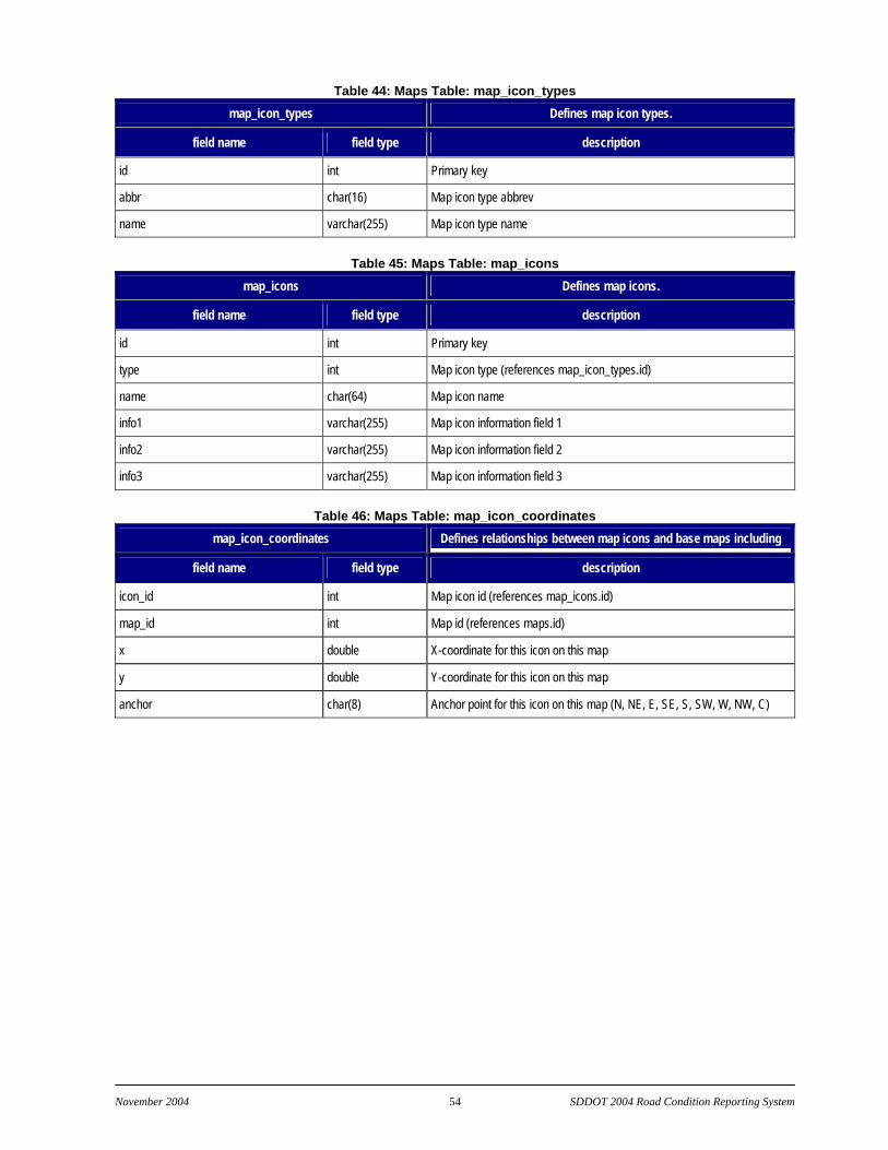
November 2004 54 SDDOT 2004 Road Condition Reporting System
Table 44: Maps Table: map_icon_types map_icon_types Defines map icon types.
field name field type description
id int Primary key
abbr char(16) Map icon type abbrev
name varchar(255) Map icon type name
Table 45: Maps Table: map_icons
map_icons Defines map icons.
field name field type description
id int Primary key
type int Map icon type (references map_icon_types.id)
name char(64) Map icon name
info1 varchar(255) Map icon information field 1
info2 varchar(255) Map icon information field 2
info3 varchar(255) Map icon information field 3
Table 46: Maps Table: map_icon_coordinates
map_icon_coordinates Defines relationships between map icons and base maps including
field name field type description
icon_id int Map icon id (references map_icons.id)
map_id int Map id (references maps.id)
x double X-coordinate for this icon on this map
y double Y-coordinate for this icon on this map
anchor char(8) Anchor point for this icon on this map (N, NE, E, SE, S, SW, W, NW, C)