i recovering the lost landcape of - …nswaol.library.usyd.edu.au/data/pdfs/13039_id_caillard...i i...
TRANSCRIPT

I I I I I I I I I I I I I I I I I I I I I
RECOVERING THE LOST LANDCAPE OF
VALERI RICETTI:
The Archaeology of an Individual
Volume 1 (Thesis)
Bobby Anne Caillard
Thesis submitted in partial fulfillment of the requirements for the degree of Bachelor of Arts (Honours)
Archaeology (Prehistoric and Historical) The University of Sydney
2005

I I I I I I I I I I I I I I I I I I I I
'A man is the history of his breaths and thoughts, acts, atoms and
wounds, love indifference and dislike; also of his race and nation, the
soil that fed him and his forebears, the stones and sands of his
familiar places, long-silenced battles and struggles of conscience, of
the smiles of girls and the slow utterance of old women, of accidents
and the gradual action of inexorable law, of all this and something
else too, a single flame which in every way obeys the laws that
pertain to Fire itself, and yet is lit and put out from one moment to the
next, and can never be relumed in the whole waste of time to come.'
(8yatt 1990:9)

I I I I I I I I I I I I I I I I I I I I I
ABSTRACT
This thesis presents historical and archaeological research into a built landscape
known as The Hermit's Cave, created by the recluse Valeri Ricetti between the
mid to late 1920s and 1952, near Griffith, New South Wales. Different types of
historical data are presented, including oral histories, official documents, local
newspaper articles and photographs. In addition, an archaeological surface
survey was undertaken in three seasons between August 2004 and March 2005,
and the colleted data are detailed and discussed.
These data are then considered in the theoretical light of cognitive archaeology,
and in particular to current phenomenological approaches to cognitive
archaeology. Phenomenological interpretations of the archaeological record aim
to assess the relationship between an inhabited landscape and an individual
cognitive experience. The Hermit's Cave complex is an example of an
archaeological landscape created by an individual known through a well
documented historical record. It therefore provides a rare instance in which
current phenomenological approaches can be assessed in regard to the
archaeology of an individual.
The study concludes that there are clear linkages between Ricetti's thought and
action manifest in the archaeological record, although the archaeological data
cannot stand alone from the historical record.
Abstract

I I I I I I I I I I I I I I I I I I I I I
ACKNOWLEDGMENTS
I wish to acknowledge and thank the many people who have helped me with this thesis and thiOUghout the course of this study.
Or Peter Kabaila, in Canberra, for giving me the lead on such a fascinating site when I rang him unannounced last March looking for an Aboriginal Historical topic!
My supervisor, Or Martin Gibbs, for his support, direction and mentoring.
Andrew Wilson for his generous time and patience in teaching me how to use the various surveying equipment, and the software programs involved, including GIS mapping.
Or Judy Birmingham for accompanying me on both survey field trips and for being a mentor, motivator and friend.
Felicity Barry for her invaluable help, cheerful enthusiasm and energy on both survey field trips.
Jamie Fraser for his input above and beyond the call of duty. He joined the second survey field trip to provide his expertise on the Total Station. Jamie also helped with the conversion of that data to CAD drawings. Even from overseas, he continued to offer his invaluable advice, moral support and criticism on my many drafts.
Veteran surveyor, lan Hayes, for twice making the journey from the Blue Mountains to teach me how to use the CAD software program.
I would also like to thank James Bugno, Jack Bicego, Peter Ceccato, Bruno and Nora Ceccato and Sam di Fiori, in Griffith, for agreeing to be interviewed by me and for sharing their memories about The Hermit. Also for providing me with archival photographs and journals. I hope I have done them justice.
Wendy Polkinghorne, at the Griffith Genealogical and Historical Society, helped me to get in touch with those people who could provide oral history. She also put me in the right direction for much of the local and archival documentary sources. Thank you.
Acknowledgements ii

I I I I I I I I I I I I I I I I I I I I I
Margaret King, at the Griffith City Library, for giving me access to a meeting room for the oral history interviews, for the use of scanning and photocopying facilities and for tracking down archival maps of Griffith.
Shirley Norris, at the Griffith Pioneer Park Museum, for locating and scanning their collection of relevant archival photographs.
George Cilliers, at Griffith City Council, for giving me permission to survey the site and for the digitalised version of the aerial photographs and contour maps which form an integral basis to my maps. Also for driving me around, for showing me the site and for letting me bother him for all sorts of information on many occasions.
Simon Greet, at Griffith City Council, for his help integrating the GPS data onto base maps.
Psychiatrist, Or Karen Arnold, helped me to diagnose Ricetti's psychotic behaviour as paranoid schizophrenia. Thank you for your time.
My friend, Marlies Laaper, thank you for teaching me the finer points of Excel spreadsheet and also for giving me a crash course in Powerpoint presentation.
My friend, Jane Butterworth, for her moral support and time proofreading the final draft.
My sister, Lorna Bussell, for taking time off work to help with the many critical and time consuming issues of final production.
Or Ken and Or Elaine Moon for inspiring me to start this journey.
And of course my husband, Andrew, for encouraging and supporting my desire to study.
iii Acknowledgements

I I I I I I I I I I I I I I I I I I I I I
TABLE OF CONTENTS - Volumes 1 and 2
Volume 1
Abstract
Acknowledgements
Table of Contents
List of Abbreviations
List of Tables
List of Figures
List of Appendices
Chapter 1 Introduction
Background
The Case Study Site
Research Aims
The Method
Thesis Structure
Chapter 2 Cognitive Archaeology - A Literature Review Introduction
Overview
Phenomenological Approach
Concerns
Historical Association
Subjectivism
Summary
Table of Contents
ii
iv
vii
viii
ix
xii
1
1
2
2
3
4
5
8
10
11
13
13
iv

I 'I I
I I Chapter 3 Contextual Background: Griffith, and 'The Hermit', Valeri Ricetti
Introduction 15
I Scenic Hill - Historical Overview 18
Griffith - Historical Overview 19
I Historical Sources 20
The Life of Valeri Ricetti based on Historical Sources 28
I Summary 35
I Chapter 4 The Case Study Site: The Hermit's Cave Complex
I Introduction 36 Location 38
I Sub-Division of the Site 38
Geomorphology 41
I Flora and Fauna 42
Climate 42
I Site Formation Processes 43
Summary 45
I Chapter 5 The Survey of the Hermit's Cave Complex, 2005
I Introduction 49
Methodology 50 Results of the Survey 59
I Area F - Far South Rockshelter 59
Area E - South Rockshelter 62
I Areas A & B - Southern Garden and Rockshelter 66 Area D - Central 'Hideout' 82
I Area G - 'Chapel' 83
Area H - 'The Cliffs' Rockshelter 86
I Area C - Central Stairway 89 Area M - 'Main Cave' and 'Kitchen' 91
I Table of Contents v
I

I I I Area Q - New North Shelter 100
I Area P - North Shelter 103 Area T - Western Shelter 107
I Summary 108
Chapter 6 Analysis of the Data
I Introduction 109 Location and Layout of the Complex 109
I Built Features and Construction Techniques 122 Site Evolution 131
I Cultural Influence 134 Summary 135
I Chapter 7 Discussion and Conclusion
I Introduction 136 Themes of Intentional Permanence 137
I Themes of Ingenuity and Resourcefulness 141 Themes of Paranoia 144
I Discussion of the Theoretical Issues 148 Further Research 151
I Conclusion 151
I References 153
I Volume 2
I Appendices
I I I
Table of Contents vi
I

I I I I I I" I I I I I I I I I I I I I I I
LIST OF ABBREVIATIONS
AHD Australian Height Datum
DGPS Differentiated Global Positioning System
GCC Griffith City Council
GCl Griffith City Library
GIS Geographical Information System
GPS Global Positioning System
HCC Hermit's Cave Complex
MIA Murrumbidgee Irrigation Area
NAA National Archives of Australia
PPM Griffith Pioneer Park Museum
PSD Primary Source Documents
10/10/2005List of Abbreviations vii

I I I I I I I I I I I I I I I I -I I I I I
LIST OF TABLES
2.1 Highlighting the different potentials of the various contextual data sources
3.1 List of Primary Source Documents (PS D) Cited
3.2 List of Oral History Informants and their relationship to Valeri Ricetti
4.1 Area Codes and Names for the twelve sub-divisions of the HCC site
5.1 Example of Feature Recording Sheet and explanation of data recorded for each feature or artifact
5.2 Table of Feature Types and their corresponding Codes and Definitions
5.3 Material Types and their corresponding Codes and Definitions
5.4 Features in Area M showing evidence of restoration work
6.1 Strands of evidence that exist for each area of the site
6.2 Multiple Entry/Exit Points to Defined Spaces
6.3 Some of the species of exotic vegetation planted by Ricetti
6.4 Rock Iconography attributed to Valeri Ricetti
6.5 Nature and location of incorporation of natural features
6.6 Evidence of site evolution
List of Tables
12
22
26
39
56
57
58
91
111
116
124
125
127
131
viii

I I I I I I I I I I I I I I I I I I, I I I
LIST OF FIGURES
Frontispiece Valeri Ricetti. Dated: circa 1942 (post internment). Source: (Dalton & Polkinghorne 1990:666)
3.1a Location of Griffith, NSW
3.1b Location of Griffith, Scenic Hill, the McPherson Range and the Orchards and Irrigation Canals of Griffith
3.2 The Hermit's Cave Complex and the Historic Sites of Scenic Hill
3.3 Valeri Ricetti, 'The Hermit of Scenic Hill' - circa 1938
4.1 The Hermit's Cave Complex Site sub-division
4.2 Panorama of Areas G, H, C and M
4.3 View from below Area F
4.4 Example of cultural site formation
4.5 Example of cultural site formation
4.6 Example of cultural site formation
4.7 View from Scenic Hill 1930s
4.8 Current view from Scenic Hill
4.9 Encroaching urbanisation since the 1920s
5.1 The aerial for the Trimble TDC1 Asset Surveyor GPS receiver
5.2 Area F - Far South Rockshelter
5.3 Area E - South Rockshelter
5.4 Area F - F1 S the 40 step stairway linking the ridgetop to F4DS1
5.5 Area E - Rockshelter E4DS2 and curved stairway E1SWR
5.6 Area E from below
5.7a Areas A & B - Labelling Stone Features, Non-Extant Stone Features, Terraces, Defined Spaces, Entrance/Exits, Rock Features and Pathways
5.7b Areas A & B - Labelling Artefacts, Non-Extant Artefacts, Cisterns, Gully and Vegetation
List of Figures
16
16
17
27
37
40
40
46
46
46
47
47
48
52
61
64
65
65
65
77
78
ix

I I I I 5.8 Area 8 - 821.1WR a neatly tessellating wall on the NW 79
side of water storage cistern 821 C
5.9 Area 8 - Scrap metal sheeting (842AFTMS) embedded on 79
I SW side of 87WRM
5.10 Area 8 - Rock iconography in cavern area 79
I 5.11 Area 8 - Highlighting the 1800mm drop between base of 80 840S and 8 16T below
I 5.12 Area A - Tightly fitting worked stone face and capping 80
stones of A13WRCP
5.13 Area A - Three-sided enclosure forming water storage 80
I cistern A 14C
5.14a Area A - A 17DS4 - Enclosed space formed by rock 81 formation
1,1 5.14b Area A - AX3WFC - Circular structure under A44R8 in 81 A17DS4
I 5.15 Area D - SW access (D3E) to cavity within rock formation 81
5.16 Area G - 'Chapel', Area H - 'The Cliffs' Rockshelter, and 87
I Area C - Central Stairway
5.17 Area C and H - Crevice passageway linking Areas G 88 and H to Area C
1I 5.18 Area G - Rock art (G12AFTP) in 'Chapel' grotto 88
5.19 Area H - 'The Cliffs' engraving (H1AFTE) 88
I 5.20a Area M - 'Main Cave' and 'Kitchen' - 96 Labelling Stone Features, Non-Extant Stone Features,
I Defined Spaces, Terraces, Entrance/Exits, Rock Features and Pathways
5.20b Area M - 'Main Cave' and 'Kitchen' - Labelling Artefacts, 97
.1 Non-Extant Artefacts and Vegetation
5.21a Scaled drawing of M25H - the 'Kitchen' hearth 98
I 5.21b Hearth incorporated into the wall in the 'Kitchen' 98
5.22 Area M - Fortress-like retaining walls (M2 - 5WR) 99
I 5.23a&b Rock iconography (M33AFTP) in 'Main Cave' 99
5.24 Area Q - Q6DS1 takes considerable advantage of the 101 natural rock features
I 5.25 Area Q - New North Shelter 102
5.26 Map of Area P - Far North Shelter 105
I List of Figures x
I

I I I
5.27 Area P - Diagonal lines depicted in faded white paint 106
I (P6AFTP)
5.28 Area P - P13DS1 takes advantage of natural sheer rock 106 walls
I 5.29 Area P - Naturally camouflaged from below 106
6.1a Location of Known and Unknown Areas of the HCC Site 112
I 6.1b Highlighting unknown crevice passageway that contains 113 stairs linking Areas A & B to the ridgetop
I 6.1c Highlighting unknown defined space (M39DS3) on the level 113 above the rest of Area M
6.2 Visitors to the lookout at Scenic Hill - 1928 114
I 6.3a Prominent walls in Areas A & B 115
6.3b Prominent walls in Areas G and M 115 I, 6.4a Area F - Access Ways 118
6.4b Area E - Access Ways 118
I 6.4c Area A & B - Access Ways 119
6.4d Areas G, H, C and M - Access Ways 120
I 6.4e Area D - Access Ways 121
6.4f Area Q - Access Ways 121
I 6.4g Area P - Access Ways 121
6.5a Terraces and Walls with Metal Sheeting in Areas A & B 123
I 6.5b Terraces and Walls with Metal Sheeting in Areas G & M 123
6.6 Water catchment cisterns and gully in Areas A & B 126
I 6.7a 'Non-functional' walls B 1 OWRC, B 11.1 and B 11.2 WRL 129
6.7b Location of 'non-functional' walls B10WRC, B11.1 and 129 B11.2 WRL in Areas A & B
.1 6.7c 'Non-functional' walls M4WRC, M26WRC and MX1WRC 130
6.7d Location of 'non-functional' walls M4WRC, M26WRC and 130
I MX1WRC in Area M
6.8a A typical stone wall farmhouse in Valtellina, Northern Italy 134
I 6.8b Stone wall structure in Area T 134
I I
List of Figures xi
I I

I I I I I I I I ,I I I I I I I I I I I I
LIST OF APPENDICES (in Volume 2)
Appendix 1
Appendix 2
Appendix 3
Appendix 4
Appendix 5
Appendix 6
Appendix 7
Facsimile of Primary Source Documents (PSD)
Valeri Ricetti - Timeline Database
(Based on Historical Sources)
Email from Glenside Hospital Historical Society, 25 February 2005
Letter from The Mid Western Mental Health Services, 14 February 2005
Rough Sketch Map of The Hermit's Cave, Griffith (Uoyd,2000)
HCC - Photographic Record by Area
HCC - Archival Photographs
Appendix 8 HCC - Non-Extant Feature and Artefact Database
Appendix 9 HCC - Feature and Artefact Database
Appendix 10 HCC - Feature Sheets (by Area)
List of Appendices xii

I I I I I I I I I 'I I I 'I ,I
I I I I .1 I I
CHAPTER 1
INTRODUCTION
BACKGROUND
A review of published literature concerning cognitive archaeology, and in
particular its application in landscape archaeology, has identified the major
criticisms directed against a post-processual phenomenological approach.
These criticisms arise from a perceived lack of any coherent theory of practice
and the paucity of rigour in the methods employed. The credibility and the extent
to which it is possible to reconstruct past mental processes from archaeological
remains have been called into question. The current study provides an
opportunity to investigate these issues and concerns.
THE CASE STUDY SITE
The landscape under investigation has been created by an individual. It is
situated on Scenic Hill on the northeastern outskirts of Griffith, New South Wales
and is known to the local residents as 'The Hermit's Cave'. On this steep, rocky
section of the McPherson Range, a North Italian migrant with a mental disorder,
Valeri Ricetti, lived as a recluse between the mid to late1920s and 1952.
Misleadingly called 'The Hermit's Cave', the site in reality comprises a complex of
shelters, terraced gardens, exotic plants, water cisterns, dry-stone walling and
Chapter 1 Introduction 1

I I I
!I I I I I I, I I I il I' I ,I
I I I I
linking bridges, stairways and paths that stretch intermittently across more than a
kilometre of the escarpment. These structures have been created by moving
hundreds of tons of stone and earth, together with the ingenious incorporation of
natural features in the landscape. In some areas, natural rock faces have been
decorated with painted and incised markings. Throughout this dissertation, the
site will be referred to as the Hermit's Cave Complex (HCC).
RESEARCH AIMS
The primary aim of this research is an investigation of the extent to which it is
possible to trace the cognitive processes of an individual through their
archaeological remains. The key issues explored, based on the case study site,
are an interpretation of the motivational and behavioural processes of Valeri
Ricetti. In addition, this study will consider the relationships between the different
data sets.
THE METHOD
This research has used both archaeological and historical evidence. The
historical data was compiled from documentary sources, oral history sources and
photographic evidence. The archaeological data was collected through intensive
surface survey of the Hermit's Cave Complex. Maps and tables were prepared
as an analytical tool. The analytical structures investigated have included the
phenomenological context: the unquantifiable metaphysical elements of
experience that allow an interpretation of the relationship between the subject
under study and the inhabited space.
2 Chapter 1 Introduction

I I I I I i I I I I I I I I I I I I I I I
THESIS STRUCTURE
This Chapter has outlined the setting of the project, the aim of the research and
the research design. Chapter 2 presents a review of the theoretical background
and framework in which this research is set. It provides an overview of the
development of cognitive archaeology and the issues and concerns of a
phenomenological approach to cognition. Chapter 3 provides the historical and
biographical context to the study based on documentary and oral history sources.
It also discusses the character insights that these sources reveal. Chapter 4
defines the case study site and provides the geomorphological and
environmental setting as well as the site formation processes. Chapter 5 sets out
the methodology of the survey, the nature of the data collected and the results of
the survey. Chapter 6 presents the patterns and trends that have emerged from
an analysis of the data. The results of the analysis and the conclusions drawn
from this investigation are discussed in Chapter 7.
Chapter 1 Introduction 3

I I I I I i I I I I I I I I I I I I I I I
CHAPTER 2
COGNITIVE ARCHAEOLOGY: A Literature Review
This chapter outlines the theoretical context in which this research is set. It
provides an overview of the development of cognitive archaeology and its
application in landscape archaeology. The issues and concerns of a cognitive
approach are highlighted, and the rationale for undertaking the current
investigation will be discussed.
INTRODUCTION
In recent years archaeologists have begun to appreciate the fact that the
landscape holds valuable if neglected insights into our understanding of the past
and that we need to adopt a new approach to its interpretation. This approach
sees landscape not only as constituted of sites, topographical features and an
environmental record, but also as an expression of human experience - the
phenomenology of landscape (Children & Nash 1997:2). In this light, landscape
is understood as an entity that exists by virtue of its being perceived, experienced
and contextualised by people (Knapp & Ashmore 1999:2). A phenomenological
approach to landscape has evolved out of post-processualist trends that include
cognitive behaviour as a vital facet of archaeological interpretation. However,
there has been much contention over the methodology and feasibility of this
aspect of archaeology. The current study will consider these issues in the light of
investigating the behaviour and motivation of Valeri Ricetti, and the cognitive
processes involved in the creation of an unusual landscape by a reclusive
individual with an apparent mental disorder.
4 Chapter 2 Cognitive Archaeology: A literature review

I I I I I I I
i I
I I I I I I I I I I I I I
OVERVIEW
Landscapes have long been an interest in archaeology. However, perceptions of
landscape, emanating from the New (Processual) Archaeology of the 1960s,
were based on functionalist explanatory frameworks with a strong emphasis on
material remains and a commitment to the idea that subsistence behaviour was
the infrastructure of cultural systems. Indeed, some proponents of the more
recent approaches even suggest that landscape was once considered as a
neutral, unchanging, abstract dimension conceptually and physically separated
from human activity (Rubertone 1989:50; Tilley 1994:9; Knapp & Ashmore
1999:2). Certainly, landscapes tended to be looked at as a series of quantitative
scientific data that focused on settlement patterns, technology, resources and
land use - on what people did to the land and how it aided or constrained them,
rather than what they thought or felt about it (Children & Nash 1997:2; Knapp &
Ashmore 1999:7).
A phenomenological approach to landscape has developed through the relatively
recent interest in cognitive archaeology that evolved in the early 1980s as part of
the post-processual split from processualism. This movement is also referred to
as symbolic, structural, contextual, hermeneutic, relativist and interpretive
archaeology (Hodder 1993:253). The basic theoretical assumptions of this
orientation, influenced by insights gained from Critical Theory (Hodder 1989:17;
Shanks & Tilley 1989:2; Renfrew 1994:3), are that culture exists in people's
heads, but the activities that are shaped by culturally constructed meanings take
place in the real world and impact on that world; all material culture produced is
shaped by mental processes (Leone 1982:742). As expressed by Hampton
Adams (1993:29), thought and action are inseparable and thus archaeological
5 Chapter 2 Cognitive Archaeology: A literature review

I I I I I I I I I I I I I I I I I I I I I
data cannot be entirely understood within a scientific framework of laws and rules
because of the fundamental agency of free will.
In spite of its earlier dismissal as 'unreconstructable', and condemned as
'paleopsychology' by die-hard processualists such as Binford (Leone 1982:743;
Renfrew 1994:4), the necessity to place some emphasis on recovering the
mental phenomena of past behaviour became more accepted as archaeologists
recognised the limitations of a materialistic evolutionary and ecological approach
to explain the variability observed in the archaeological record (Trigger 1989:28;
for example see Renfrew & Zubrow 1994; Whitley 1998). Renfrew (1989:34;
1994:3) has commented that this saw processual archaeology move from a
functional-processual base, to a cognitive-processual base. Nonetheless,
despite much common ground between the theoretical persuasions there exists a
vast divide concerning the methodology and the degree to which a credible
reconstruction of past cognitive behaviour is possible. From a cognitive
processual perspective cognitive archaeology is seen as being part of an holistic
approach to the wider enterprise of archaeology (Renfrew 1993:248; Flannery &
Marcus 1993:260; 1998:37) and is defined as 'the archaeology of past ways of
thought as inferred from material remains' (Renfrew 1994:3). However, from a
post-processual phenomenological point of view 'cognitive archaeology
emphasises the need to focus on how people perceive and understand
themselves, their relationships, and the world (real or imagined) around them'
(Bender 1993a:257). Others have argued that as a result of the haphazard,
unsystematic nature of its growth, cognitive archaeology remains an undefined
area of study with a wide divergence of views (Flannery & Marcus 1993:260;
Hodder 1993:253).
Renfrew (1989; 1993; 1994; 2001), the most vociferous critic of an interpretive,
contextualist approach, reacted to what he perceived as an attack from post
processualists such as Shanks & Tilley (1987a; 1987b) and Hodder (1982) on
traditional archaeology, and a comprehensive rejection of scientific methods and
6 Chapter 2 Cognitive Archaeology: A literature review

I I I I I i I I I I I I I I I I I I I I I
an objective basis. Processualists such as Cleland (1988: 15), Trigger (1989:29)
and Renfrew (1989:33) challenged the new approach as adopting a relativist
position that reduced archaeological interpretation to little more than subjective
'past-as-wished-for' constructions. Proponents of the new approach, however,
claimed they were arguing not for an abandonment of scientific data but for the
inciusion of analyses that went beyond the surfaces of the empirical world to
uncover the underlying structures constituted by rules and principles which help
to constitute meaning (Shanks & Tilley 1989:3). They proposed a shift in
analysis from the objects themselves to the social and symbolic relationships
between them and the people who made and used them (Shanks & Tilley
1989:3; Hodder 1999:70).
Hodder theorised a hermeneutic procedure of creating a diale~tic process of
interaction between the different 'circles of context'. He describes it as the
'interweaving, or connecting, of things in their historical particularity' (Hodder
1986:119; 1991:7). The concept being, as highlighted by Yentsch, 'that one
cannot understand the parts of an entity without some sense of the whole which
they comprise nor can one comprehend the whole until one has seen the parts
from which it is made' (cited in Orser 1996: 183). Thus, a contextual cognitive
approach considers all known past experiences as relevant and part of the
record that can help to explain human actions and motivations. Ambiguities and
disagreements within the different data sets can be critically applied in a manner
of circular reasoning (hermeneutics) that moves between past and present,
object and subject, between the different data sources - archaeological
evidence, oral history, written sources, ethnographic data, anthropological
history, human experience - the (idealistic) aim being, as Geertz summarises, 'to
draw large conclusions from small, but very densely textured facts' (Hodder
1991: 11; Geertz 1993:28; Yamin & Methany 1996:xiv).
Cognitive archaeology applies Bourdieu's concept of habitus (Renfrew & Bahn
2000:215): that socially constituted structuring principles or mental dispositions,
Chapter 2 Cognitive Archaeology: A literature review 7

I I I I I I I I I I I I I I I I I I I I I
schemes of perception and thought, operate within each individual (Bourdieu
1977: 15). This concept proposes that the way in which individuals perceive and
function in the world and accept as natural 'givens' or norms are culturally
specific: they are developed and adopted by humans in society and in turn
govern the expectations and assumptions of everyday life. Thus, habitus can be
regarded as an informing ideology that is communicated and reproduced through
a process of socialisation or enculturation in which material culture plays an
active role (Renfrew & Bahn 2000:215). In other words, people are socialised
into ways of thinking and doing. Whilst the emphasis is on the autonomy of the
individual and individua'l agency, it must also stress the limits on that autonomy,
summarised by the Marxist truism that people make themselves, but not always
under conditions of their own choosing (Bender 1993a:258). There is a need to
focus on the fields of power within which different people (and their voices) are
empowered or marginalised, and which allow negotiation and subversion
(Hodder 1991 :9; Bender 1993a:258). Hence, an adequate approach to cognition
demands the inclusion of the social context; the social meanings, social
structures, relations of power and domination (Hodder 1999:256). These
socialised perceptions and reactions of 'Being-in-the-world' (Tilley 1994: 11;
Bender 2001 :2), variously referred to as 'mind-set' (Oeagan 1982: 168; Schuyler
1988:38), 'cognitive map' or 'mappa' (Renfrew 1994: 1 0) and 'predisposition'
(Hodder 1993:254), serve as the referents used by the individual in determining
his or her own intentional actions.
PHENOMENOLOGICAL APPROACH
A post-processual phenomenological approach to cognition, however, as applied
in the more recent studies of landscape archaeology (see Bender 1993b; 2001;
Tilley 1993; 1994; Knapp & Ashmore 1999), takes this concept of socialised
thinking and doing to a highly individualistic, and arguably elusive, intensity. A
8 Chapter 2 Cognitive Archaeology: A literature review

I I I I I I I I I I I I I I I I I I I I
phenomenological approach looks at the relationship between the inhabited
space and social 'Being-in-the-world' and involves the understanding and
description of the metaphysical as they are experienced by a subject; the
perception of the space through seeing, hearing, touching, smelling; through
bodily actions and movements; intentionality; through emotion and awareness
embodied in systems of belief and decision making; and through remembrance
and evaluation (Tilley 1994:12). Bender (1993a:258; 2001:1) advocates this
multifaceted perception and engagement with the material world, 'real or
imagined', as being concomitantly contextual, polysemic and biographical.
Contextual by its link to the particularities of time and place, that is, the social,
political, economical and environmental conditions; polysemic, in that it operates
at many different levels depending on which bit of ourselves we bring to the
encounter which in turn depends upon the context; and biographical, which is
different for different people - not only according to the specifics of gender, age,
status, ethnicity and so on, but also life experiences.
Accordingly, as neither place nor context nor self, including attitudes and
opinions, remain static - being always in a state of change, always 'becoming' -
at all times and all places, people will engage differently with the world around
them and no two experiences can be the same (Tilley 1994: 11; Darvill 1999: 107;
Bender 2001: 1). However, the element of personal experience cannot be
quantified (Children & Nash 1997:2). Thomas (2000:3) calls for 'methods that
are context-specific, strategically employed and designed to elicit particular
information from particular sets of evidence' highlighting that the knowledge
produced will not necessarily be one from which it would be possible to
generalise. Tilly (1994:11) posits there can be no clear-cut methodology arising
from such a complex notion of the experience of space and proposes that such
an approach requires a continuous dialectic between ideas and empirical data.
Tilley's (1994) radical approach to the major perennial question of pre-historic
times - why particular locations were chosen for habitation and the erection of
Chapter 2 Cognitive Archaeology: A literature review 9

I I I I I I I 'I I I I I I I I I I I I I
monuments as opposed to others - was based on phenomenology. He focused
on the relationship between the sites and monuments of his studies (in Britain)
and what he calls 'the bones of the land'; the mountains, hills, rocks and valleys,
escarpments and ridges which have remained substantially unchanged since the
Mesolithic. By looking at the patterns of distribution, intervisibility and orientation,
as a means of understanding how people perceived the landscape in which they
lived, Tilly concluded that the choices made were not always the result of
'rational' decision-making based on functional interdependencies involving
environmental factors such as relief, climate, soils, water and food supply which
is the focus of a standard approach to this question. Tilley proposed that the role
of social memory and the symbolics of landscape perception, such as the
particular sets of meanings and connotations, also play a significant role in the
choice of site location.
CONCERNS
Nonetheless, there remains scepticism of the validity of an experiential
(phenomenological) approach which continues to be criticised for its lack of a
coherent methodology and of offering, at times, insights that are not easily
distinguishable from imaginative speculation (Flannery & Marcus 1993:261;
Renfrew 1993:249; 1994:11; 2001 :21). Renfrew (1994:6; 2001 :15) argues that
where the cognitive-processual approach seeks to gain insights into how the
minds of past people worked and the manner into which that working shaped
their actions, the phenomenological approach seeks 'to enter the mind' of past
individuals involved through some effort of active empathy; to achieve the total '1-
was-there' experience of being that other long-dead person or at least
undergoing an experience to be compared with theirs.
~ ____________ ~ ______________________________________ 10 Chapter 2 Cognitive Archaeology: A literature review

I I I-I I i ·1 I I I I
I I I I I I I I I I I
HISTORICAL ASSOCIATION
Flannery and Marcus (1998:36) are of the opinion that a cognitive approach is
only feasible under appropriate conditions; that is, when there is an adequate
body of supporting background (Le. historical) data and with rigorous analysis
based on a wide range of social sciences. Certainly, the most rapid progress in
recovering the cognitive dimension has been achieved in the archaeology of
historic periods, where access to other sources of data; 'the spoken word, the
written word, preserved behaviour and observed behaviour', have provided a
greater contextual basis from both the etic aspect (direct or indirect observation
of human behaviour), and the emic aspect (the perceptions and beliefs that the
subject(s) hold concerning their own behaviour) (Schuyler 1978:269; Leone
1982:742; Renfrew 1993:250). Schuyler (1978:269; 1988:38) postUlates that
artefacts do not speak for themselves. Although the emic context is present, it is
only understood through direct historical association. On this point, Trigger
(1989:30) goes so far as to suggest that the detailed meanings ascribed to the
mental processes of prehistoriC cultures remain a matter of 'pure conjecture'.
As Renfrew (1994:4) has pointed out, the philosophers of Critical Theory, who
influenced the post-processualists, were looking for 'meaning' located within the
minds of specifically identifiable historical personages, and for whom historical
explanations of their intentions are to be found. This can equate with historical
archaeology for which there exists other sources of data. The method in
cognitive archaeology of the historical period is to give each data set a separate
epistemological status and to view them as independent and un identical
phenomena with different strengths and weaknesses. Such an approach allows
for the concept of contradiction, since, even within one society, artefacts and
written records, for example, were used and produced by different people for
different purposes, at different times and survived for different reasons (Leone
~ ____________________________________________________ 11 Chapter 2 Cognitive Archaeology: A literature review

I I I' I I -I, t I I I I I I I I I I I I I I
1988:33). To take this concept of non-correlation even further, even on an
individualistic basis, what people say, do and think are not necessarily congruent
and highlights the value of an integrated multi-perspective analysis of data
(Rathje 2001 :71). Schuyler (1978:275) advocates, albeit simplistically, that an
understanding of the interrelationships and potential unification of the
documentary and non-archaeological data with the archaeological record is the
key to gaining a more replete emic/etic reconstruction (Table 2.1).
ETIC EMIC (Behaviour) (Concepts)
Archaeological Directly Present But Context Available Not Available
Historical Indirectly Directly Context Available Available
Oral History Indirectly Indirectly Context Available Available
Ethnographic Directly Directly Context Available Available
Table.2.1 - Highlighting the different potentials of the various contextual data sources (after Schuyler 1978:273)
One of the key problems with developing an effective methodology lies in the fact
that the theoretical issue is rarely, if ever, considered on a case-by-case basis in
the archaeological record. Interestingly, a recent anthropological study
(supervised by Or Robert Schuyler) aimed to reconstruct the life of an African
American escaped slave, Joseph Johns, who lived a hermit-like existence in a
mountain-top hut in Lebanon County, Pennsylvania. This project also
investigated the potential for archaeology to make a contribution (Welch 2002).
Welch concluded that, apart from being able to provide more conclusive
evidence on aspects such as the date of Johns' arrival at the hut and the extent
to which he was 'self-sUfficient, archaeology would be able to shed light on how
~~~ __ ~~~~~~ __ ~~~ __ ~ ______________________ 12 Chapter 2 Cognitive Archaeology: A literature review

I I: l' I I i I, I I I I I I I I I I I I I I
Johns saw himself and his relationship to the community, where documentary
and oral histories could only provide an understanding of how he was received
and tolerated by the community (2002:39).
SUBJECTIVISM
The move to a new approach has made archaeologists increasingly aware of the
subjective factors that influence every level of archaeological interpretation as
there is no such thing as an impartial, value-free observer (Leone 1982:750;
Trigger 1989:29; Shanks & Tilley 1989:2). In particular, the way in which we look
at cognition takes place in the context of a series of pre-understandings and
prejudices; how we think about and give meaning to their meanings is also
embedded in our own particular historical consciousness, which we cannot
evade. A critical self-awareness, or self-positioning, that defines both 'us'
(subject) and 'them' (object) and that inter-relationship, as a means of
distinguishing between past and present ideologies or taken for granted
assumptions, should be seen as an integral part of trying to understand the
perceptions and understandings of another time (Leone 1982:751; Schuyler
1988:41; Bender 1993a:257; Hodder 1993:256). In this light, the 'hermeneutic
circle' does not have an 'outside'; the position of the interpreter, who is the
means through which any understanding of the situation is to be achieved, is part
of the context (Thomas 2000:3). Post-processualists propose that this is the very
reason for the failure to found a 'post-processual method'. The claim being that a
universal authoritative epistemology would imply that there was a single definitive
knowledge of the past (Thomas 2000:3).
~ __ ~ __ ~~~~~~ __ 77.~~ __ ~ ______________________ 13 Chapter 2 Cognitive Archaeology: A literature review

I, I I I I i I I I I I I I I I I I I I I
I
SUMMARY
The issue of cognition in post-processual archaeology has therefore reached a
theoretical cul-de-sac: despite a profusion of literature defining the theoretical
advantages of a phenomenological approach to cognitive archaeology, there is
an acknowledged (by post-processualists) and criticised (by processualists) lack
of any clearly defined methodological procedures. The issues discussed in this
literature review concerning the methodology and feasibility of a post-processual
phenomenological approach to cognitive archaeology will be considered in the
current study based on the Hermit's Cave Complex; a landscape created by an
individual with an apparent mental disorder. This investigation is set in the
historical period and uses data from archaeological, pictorial, oral history and
documentary sources. Whilst it thus avoids the concerns, as outlined, of those
who feel that any attempt to engage in the mindset of prehistoric or of any other
past culture without direct historical association is fraught with problems, it will
nonetheless review the implications of an interpretation of the archaeological
record aided by historical data sources. This research has provided an
opportunity to investigate the degree to which a credible reconstruction of past
cognitive behaviour of an individual is possible through a post-processual
phenomenological approach to cognitive archaeology.
~~~ __ ~~~~~~ __ ~~~ __ ~ ______________________ 14 Chapter 2 Cognitive Archaeology: A literature review

I I I;
I I
, i
I I I I I I I, 'I I I I I I I I
CHAPTER 3
CONTEXTUAL BACKGROUND:
GRIFFITH, AND 'THE HERMIT', VALERI RICETTI
This chapter provides the historical and biographical context to the study. A brief
historical overview of Scenic Hill and Griffith will be outlined as well as its socio
economic situation. The life of Valeri Ricetti based on documentary and oral
sources will also be discussed as will the character insights that these sources
reveal.
INTRODUCTION
A firm date for the arrival of Valeri Ricetti, a young migrant from Northern Italy, at
Scenic Hill on the outskirts of Griffith, remains elusive, as do most of the details
of his life. The varying dates in archival documentation and oral histories place it
anywhere from the early to the late 1920s. At this time the fledgling township of
Griffith, clearly visible below Scenic Hill several kilometres into the distance,
would have seemed reassuringly buffered by the wooded slopes and the flat
grazing land that separated the town from the foothills of the McPherson Range.
Today, the busy city metropolis has grown and expanded such that its northern
boundary nestles hard up against the edge of the steeply ascending rocky hill
range. The spreading suburb of Collina, with its large environment-proofed
modern houses, yapping dogs and shrieking children splashing in the backyard
pools, makes an incongruous backdrop for, only metres away, a hermit's domain:
'La mia sacra collina' (my sacred hill), as Ricetti called it (8ugno n.d.:18).
Chapter 3 Contextual Background: Scenic Hill, Griffith and The Hermit', Valeri Ricetti 15

I I I I I I I I I I I I I I I I I I I I I
N
W E
s
Figure 3.1 a - Location of Griffith, NSW
Figure 3.1 b - Location of Griffith, Scenic Hill, the McPhersons Range and the
Orchards and Irrigation Canals of Griffith
Chapter 3 Contextual 8ackaround: Scenic Hill. Gliffith and 'The Hennit'. Valeli Ricetti 16

I I I I I I I I I I I I I I I I I I I I I
Figure 3.2 - The Hermit's Cave Complex and the Historic Sites of Scenic Hill
Chapter 3 Contextual Backaround: Scenic Hill. Griffith and 'The Hennit'. Valeri Ricetti 17

I I I' I I 'i I I I I I I I' t I I, t I I I I
SCENIC HILL - HISTORICAL OVERVIEW
This particular area of the McPherson Range was frequented sporadically by
the Wiradjuri people (Pels cited in Palmer 1984:3); Aboriginal stone artefacts
have been found near the water tower opposite Pioneer Park Museum on
Remembrance Driveway (Griffith Built & Natural Environment Group 2000:28,
see AHIMS Catalogue No 0890) (Figure 3.2). In 1870, at the eastern end of
the McPherson Range, Albert Irving Driver, one of the first selectors in the area,
settled The Cliffs as a pastoral run (Kelly 1988:33); on the floor of a shallow
rock overhang the inscription 'H. M. Alt. Irv. Driver The Cliffs Born Nov. 21/-70'
is carved in elegant cursive script (Figure 3.2). Other inscriptions are dated
1931 and 1935 (BrickhiIl1979). In the early development of Griffith, Scenic Hill
was the site for various huts and shanties, particularly for the poorer settlers.
Early settlers obtained timber from Scenic Hill for building purposes and the
rocky terrain also provided a good source of building-quality stone and
aggregate (Griffith Built & Natural Environment Group 2000:28). In 1939,
stones from Scenic Hill were used to build the Catholic church, Our Lady of
Pompeii (Dalton & Polkinghorne 1990: 1 04). Berry's Brickworks was in
operation from 1924 until 1948 (Griffith Built & Natural Environment Group
2000:29) (Figure 3.2). Grazing occurred on the footslopes of Scenic Hill from
settlement up until the 1940s (Griffith Built & Natural Environment Group
2000:28). In addition, Scenic Hill, with its spectacular panoramas and natural
rock platforms, was also a place for picnics, and celebrations; 'speeches were
made on top of a rock to the people below' (Dalton & Polkinghorne 1990:101).
Today, Scenic Hill is a Crown Reserve of predominantly vacant land
(approximately 466 ha), of which Griffith City Council is Trustee. It was first
gazetted as Crown Land on 31 August 1923, Reserve No. 56353 (Griffith Built
Chapter 3 Contextual Background: Scenic Hill, Griffith and 'The Hermit', Valeri Ricetti 18

I I I I I I I I I I I I I I I I I I I. I I
& Natural Environment Group 2000:5}. Council was appointed Trustee of
Scenic Hill in 1949. However, it is only since 1971 that detailed records have
been kept regarding its use and development (Griffith Built & Natural
Environment Group 2000:9).
GRIFFITH - HISTORICAL OVERVIEW
Griffith had been declared a town in 1916 following the commencement of the
Murrumbidgee irrigation scheme, and this young settlement was fast developing
at the time of Ricetti's arrival. It is highly likely that even before his arrival in
Griffith, Ricetti was aware of this area recently opened up to agriculture. The
proposed irrigation scheme had been extensively advertised throughout Europe
and Australia, but particularly targeted were the mining areas of New South
Wales and South Australia where people were considered to be familiar with a
hard frontier type lifestyle (Polkinghorne 2004). The push to encourage potential
farmers to the Murrumbidgee Irrigation Area (MIA) coincided with the closure of
some of the Broken Hill mines, and the ensuing loss of jobs (Kelly 1988:168).
Consequently, a significant proportion of the original settlers to Griffith included
migrants form Northern Italy who had been working in these mining areas
(Polkinghorne 2004). It is possible, therefore, that Ricetti had heard about it
before his departure from Northern Italy, or perhaps even during the couple of
years he spent working in the mines at Broken Hill (pers. comm. P Ceccato
5.8.2004). Indeed, Francesco Bicego, (oral history informant Jack Bicego's
father), whom Ricetti had worked with and befriended in Broken Hill, had already
spent time working in Griffith in 1913 to 1915 and had advised Ricetti to 'try (his)
luck in Griffith' (Kelly 1988: 167).
~~~ __ ~~~~~ __ ~~~~~~~~~~ __ ~ __ ~~=-__ 19 Chapter 3 Contextual Background: Scenic Hill, Griffith and 'The Hermit', Valeri Ricetti

I I' I,
I I i I I I,
t I I I I I' I I I I 'I I
HISTORICAL SOURCES
The life story of Valeri Ricetti, 'the Hermit of Scenic Hill' - for that is how he is
known by most people - remains largely shrouded in folkloric mystery. The only
official documentation resulting from his time in Australia stems from his arrest
and internment as an enemy alien during World War 11 between March 1942 and
December 1943. Though he interacted with local residents, Ricetti lived a rather
secluded life on his hillside domain and the different surviving accounts of his life
originate from a limited number of people. These few accounts have taken on a
legendary status, perpetuated by generations of residents in Griffith. Archival
and more recent newspaper accounts, and other compiled histories both oral and
written, have inadvertently diffused, altered, romanticised and obscured the
details of Ricetti's life. For example, both The Area News (Fenwick 1.12.1989)
and The Melbourne Agenda (Ellis June 1996) report that Ricetti used 'Stone Age
tools' to create and shape his garden. However, archival photograph (APH.M5 -
Appendix 7) and the archaeological record (Feature Nos. B31AFTM and
B41AFTM - Appendix 9) would make this seem unlikely as he clearly had access
to rather more conventional gardening tools, albeit rescued from the town dump
(pers. comm. J.Bugno 5.8.2004; P.Ceccato 5.8.2004).
Another reason for the conflicting, contradictory and missing details is Ricetti
himself, who, it would seem, was intent on confusing the issue by being
intentionally vague, elusive and at times misleading, especially when being
questioned by the authorities, as discussed below.
It is interesting to note that much of the information about Ricetti's early time in
Australia before settling on Scenic Hill in the late 1920s (Bugno n.d.:5) originates
from the official documentation from many years later; 1942-1944. Thus, the
information that Ricetti gives to the various authorities stems not only from
memories with an up to 20 year temporal distance, but also from the time that he
had decided to remove himself from society.
~~~ __ ~~~~~ __ ~~~~~~=-~~~ __ ~~~~~__ 20 Chapter 3 Contextual Background: Scenic Hill, Griffith and The Hermit', Valeri Ricetti

I I' I I I i I I I I I I I' I,
I I I I I I I
Documentary Sources
There exists limited documentary evidence of Ricetti's life and nothing written by
him directly. However, the primary documentary sources (see Wood 1990:82)
include: government records produced between March 1942 and March 1945
(these documents are lodged at the National Archives of Australia); a transcript
of Ricetti's employee record relating to BHP Mines Broken Hill; and three archival
articles from The Area News (the local newspaper).
These documents have been treated as artefacts and analysed in context rather
than being taken at face value. In respect to the official documents,
consideration has been given to the imbalance of power and assertion between
Ricetti and the authorities who produced them for their own purposes (Wood
1990:82; Moreland 2001 :26). Nonetheless, they are contemporaneous
recordings, written in the same historical and social atmosphere, and they give
direct insights into others' perspectives of Ricetti's character. Table 3.1 below
sets out a List of Primary Source Documents (PS D) cited in this thesis. These
documents are referenced PSD #. A facsimile of these documents can be found
at Appendix 1.
The use of secondary historical sources has been limited to discussing the
overarching historical socio-political context.
~~~--~~~~~--~~~~~~~~~~ __ ~~~~=-__ 21 Chapter 3 Contextual Background: Scenic Hill, Griffith and The Hermit', Valeri Ricetti

I I I I I I I I
I I I
I. I I I I I
List of Primary Source Documents Cited
Title I Type Produced I RefCode of document Written by Ito Date Source in Thesis Photocopy of Employee J. Bicego Record re BHP Mines Unknown undated J. BUQno PSD1 'Hermit's Cave Molested' The Area News
The Area News 30.4.1934 Page 1 PSD2 'Hermit Injured Admitted to The Area News Hospital' The Area News 19.11.1934 Page 1 PSD3 'Recluse's Work On Griffith The Area News Scenic Hill' The Area News 19.11.1934 PaQe unknown PSD4 Commonwealth of Australia, National Security T J Ellis, Police Station, National Archives (Aliens Control) Griffith 4.3.1942 of Australia (NM) PSD5 Regulations - 'Form of Series SP11/2, File Application for Registration' Volari Ricitti (sic) (For Alien resident in Australia) Letter The Officer-in-Charge of REF: National Security Police, Griffith to The 12.3.1942 NM PSD6 (Aliens Control) Commissioner of Police, Series C123/1 Regulations. Part 11. Sydney File 18552 Regulation 5. Australian Military Forces Prisoners of War 'Internee Prisoner of War- Information Bureau, Undated NM PSD7 Service and Casualty Form' Liverpool Internment Series: MP11 03/1
Camp, Sydney N/A PSD8 Letter From Military Police , Subject: Attached Intelligence Section, 3.4.1942 NM PSF9 questionnaire for Sydney to Officer-in- Series C123/1 completion Charge of Police, Griffith Item 18552
Letter Ref. Circular No. 42/89 T J Ellis, Police Station, 17.4.1942 NM PSD10 Enforcement of National Griffith to The Series C123/1 Security (Aliens Service) Commissioner of Police, Item 18552 Regulations Sydney
Sent by Military Police Questionnaire Intelligence Section (MPI), NM (4 pages) Police Headquarters, 10.4.1942 Series C123/1 PSD11
Sydney to be completed Item 18552 at Griffith Police Station
NM Hand written memo Sergeant Rushton, 1.5.1942 Series C123/1 PSD12
Item 18552 Carbon copy (no heading) NM 'Internment of Aliens' undated Series C123/1 PSD13
Item 18552
continued .....
22 Chapter 3 Contextual Background: Scenic Hill, Griffith and The Hermit', Valeri Ricetti

I I I I I i I I I I I I I I I I I I I I I
..... continued
Title I Type Produced I of document Written by Ito Date Source Letter Subject: Volari Ricitti (sic), Sergeant Ellis, Police 4.5.1942 NAA enemy alien of Italian Station, Griffith to The Series C123/1 nationality, under escort to Officer-in-Charge of Item 18552 Sydney. Police, M.P.I. Section
NAA 'Internee Property Sheet' Provost Corps Eastern 5.5.1942 Series C123/1
Command, Sydney Item 18552 Prisoners of War Information Bureau- Liverpool Internment Undated NAA Nominal Roll for Month of Camp, Sydney Ca. June Series C123/1 June 1942 1942 Item 18552 Australian Military Forces 'Property Statement - No. 12 ( C) P.O.w. Camp 20.7.1942 NAA Internee' Cowra Series C123/1 (2 paQesl Item 18552
NAA Index card J. MOir, Camp 12, Cowra 29.12.1942 Series C123/1
Item 18552 Commonwealth of Australia 'National Security (Aliens From H.Q. Loveday 6 & 10. NAA Series C123/1 Control) Regulations - Group, Internment 12.1943 Item 18552 Notice of Change of Abode' Camps, Barmera to
Griffith, NSW National Security (Aliens Control) Regulations NAA Summary of previous Unknown Undated Series C123/1 Forms C. (Changes of Item 18552 Abode) National Security (Aliens Allied Works Council,
,
Service) Regulations National (Alien Services) 9.12.1943 NAA 'Notice of Deferred Service' Regulations Series C123/1
Item 18552 From Deputy Directory of
Letter Security, SA. To Director- 13.12.1943 NAA Ref No. 13768 General of Security, Series: D1901
Canberra Item: R2557 Dossier No. 18552 Extract from Security File W. S. Chenoweth, 25.10.1944 NAA No.118 Custodian of Records Series C123/1 Re: Transfer from Cowra to Item 18552 Loveday Dossier No. 18552 Extract from Security File W.S. Chenoweth 25.10.1944 NAA No.118 Custodian of Records Series C123/1 Re: Release from Loveday Item 18552
Commonwealth of Australia 'National Security (Aliens NAA Control) Regulations A.R.O., Griffith, NSW 30.11.1944 Series C123/1 'Notice of Change of Item 18552 Abode'
Table 3.1 - List of Primary Source Documents (PSD) Cited
Chapter 3 Contextual Background: Scenic Hill, Griffith and The Hermit', Valeri Ricetti
RefCode in Thesis
PSD14
PSD15
PSD16
PSD17
PSD18
PSD19
PSD20
PSD21
PSD22
PSD23
PSD24
PSD25
23

I I 1<
I I i I I I I I I I I I I I I I I I
Archival Photographic Sources
Pictorial data has been collected from various sources: local residents; the
Pioneer Park Museum in Griffith; Griffith City Library; the Griffith and District
Pioneers Series (Dalton & Polkinghorne 1990); oral history informant Peter
Ceccato's book (2001); and archival newspaper articles. They are all from black
and white photographs and, apart from three (APH.81, 83 and 84 - refer to
Appendix 7) which were originally used as tourist souvenirs (pers. comm.
P.Ceccato 5.8.2004), they are amateur, informal 'snaps' taken with
unsophisticated equipment. Some of the pictures have been damaged by crease
marks, moisture stains, or fading. The majority of them are undated, or at best,
vaguely dated to the 1930s. A few photographs are obscure and it has not been
possible, as yet, to determine exactly which area of the site they depict. The
archival photographs (APH) have been allocated a site area code reference. For
example, APH.A1 refers to a specific archival photograph depicting an aspect of
Area A. Facsimiles of the archival photographs and their sources can be found
in Appendix 7.
The photographic evidence represents an important primary resource. The
depictions of Ricetti reveal his physical appearance and general demeanour and
are a key to his relationship with the outside world. The archival photographs
have also been used for assessing the original nature of the structures and for
some aspects of site location. They have provided evidence of features that are
no longer extant and are also a good indication of site evolution and modification.
These aspects will be discussed more fully in Chapter 5.
~~~--~~--~~--~~----=---=-----~______________ 24 Chapter 3 Contextual Background: Scenic Hill, Griffith and 'The Hermit', Valeri Ricetti

I I I I I
, i
I I
I I I I I I I I 'I I I
:1 :1 I
Oral History Sources
The oral histories relating to Valeri Ricetti were collected during the first field trip
to Griffith (4-7 August 2004) through a series of pre-arranged interviews held at
the Griffith City Library or on site or both. The interviews were conducted on an
informal basis, guided by a few initial questions which aimed to establish the
background to the informants' relationship with Ricetti and to stimulate a free
flowing narrative. These details are set out below in Table 3.2.
Written oral histories, in the form of published or handwritten manuscripts and
letters have been included in this category of data. A distillation of this
information has been set out for analysis as a timeline database in Appendix 2.
The evidence provided by the oral histories has been evaluated based on
guidelines set out by Hoffman (1996) and Wood (1990:82). First hand, or
eyewitness, accounts have been regarded as primary sources and have been
given a greater weighting of reliability than those of handed-down memory, or
hearsay. In addition, the temporal distance and the fact that some of these
recollections are from a childhood perspective have also been taken into account
during analysis.
The data derived from documentary, pictorial and oral history sources have
provided a broad contextual background to Ricetti's life as well as insights to his
character, which are discussed below. In Chapter 7 this data will be considered
in conjunction with the archaeological record.
~~~--~~~~~--~~~~~~=-~~~--~~~~~__ 25 Chapter 3 Contextual Background: Scenic Hill, Griffith and The Hermit', Valeri Ricetti

I I I I I I I I I I I I I I I I I I I I I
Informant -Name and Age Nature of contact with Valeri Ricetti
(if known) First met Ricetti around 1936/7 when he was 10 or 11 years old. Mr
Bicego spent 'most of (his) school days' up on the Hill. Ricetti at times
Mr Jack Bicego (77) worked and slept at the Bicego family farm, Lot 340.
Mr James Bugno
(80)
Mr Peter Ceccato
(80s)
Mr Bruno (86) and
Mrs Nora (80)
Ceccato
Mr Sam di Fiori
MrsWendy
Polkinghorne
First met Ricetti in 1934. He was a child of 10 and often 'wagged' school
to go up to the Hill to spend time with Ricetti. Mr Bugno also gave me a
manuscript, written in 1988, and a book of notes, written in the early
1980s, of his memoirs of Ricetti
Ricetti had lived at Peter Ceccato's father's boarding house in Broken
Hill and when reacquainted with Ricetti in Griffith in 1937, Ricetti would
at times be invited to the Ceccato home for Sunday lunch. Peter, in his
teens, also visited Ricetti at the Hill. On Ricetti's release from P.O.W.
internment, Peter spent several years working alongside him in the
orchards and vineyards on his father's farm listening to Ricetti's
recollections. Peter Ceccato's published account of Ricetti's life story
was written in 1999, motivated by the distorted versions of Ricetti's life
that were beginning to appear (Ceccato 2001 :13).
Bruno Ceccato is Peter Ceccato's elder brother. Ricetti lived and
worked on Bruno and Nora Ceccato's farm from 1943 until his departure
for Italy in 1952.
Mr Fiori had seen Ricetti only once, as a young boy of about 10.
However, since the early 1970s he has been collecting archival
photographs and 'stories' in a bid to piece together Ricetti's life history.
Mr Fiori instigated and oversaw the restoration work carried out by the
Wade Apex Club.
Mrs Polkinghorne is the librarian for the Griffith Historical and
Genealogical Society. She had never actually met Ricetti but
remembers childhood stories about him. As a young girl she was taken
to Scenic Hill for picnics. Her interest in local history has led her to put
together a body of archival documentation relating to Valeri Ricetti. Mrs
Polkinghorne is the co-editor of The Griffith & District Pioneers series.
Table 3.2 - List of Oral History Informants and their relationship to Valeri Ricetti
26 Chapter 3 Contextual Background: Scenic Hill, Griffith and 'The Hermit', Valeri Ricetti
I

I I I I I I I I I I I I I I I I I I I I I
Figure 3.3 - Valerie Ricetti, 'The Hermit of Scenic Hill' - circa 1938 (Source: Ceccato 2001: 14)
_____________________________________________________ 27
Chapter 3 Contextual Backaround: Scenic Hill. Griffith and 'The Hermit'. Valeri Ricetti

I I I I I i I I I I I I I I I I I I I I I
THE LIFE OF VALERI RICETTI- based on Historical Sources
Valeri Ricetti was born around 1897/8 in Sondalo, Valtellina, North Italy (PSD5;
Ceccato 2001:15). In his home region, he had been apprenticed as a cement
and stonemason (Ceccato 2001:15) and gained experience working on road
and rail tunnel constructions (Bugno n.d.:1). However, at the age of 16 or 17,
the declining economic situation and impending war in Europe led his uncle to
encourage him to migrate to Australia to seek better opportunities (J. Bicego
pers. comm. 5.8.2004).
Ricetti arrived in South Australia at either Port Pirie (Ceccato 2001: 15) or Port
Adelaide in October 1914 (PSD5), though the name of the ship and the day of
landing are unknown. When asked for these details in 1942, Ricetti said 'he
could not remember' (PSD5). However, his apparent vagueness does not tie in
with the level of detail he is able to recall on other occasions, such as his later
recounts to Peter Cecatto (during the mid to late 1940s) that include the
minutiae of places, jobs, people and events of his travels around the country
between leaving Broken Hill and arriving in Griffith (see Ceccato 2001). It
should be noted though, that there is after all a 50 year temporal distance in the
hearing (from Ricetti) and the telling (by Ceccato).
Ricetti also informed the authorities that he left his passport at the Adelaide
Police Station, though subsequent 'inquiry failed to reveal that passport had
been left there' (PSD5). This lack of information would have prevented, or at
least made it extremely difficult for, the authorities proceeding with any further
investigation of his background. The checks made by Griffith Police to the
Adelaide Police also revealed that 'examination of [Ricetti's] fingerprints shows
that this alien was known as Frank Pullen & Frank Muler' (PSD5). Interestingly,
this is one of several different names that Ricetti has used over time, as
highlighted below.
~~~--~~~~~--~~~~~~--~~~~~~~~__ 28 Chapter 3 Contextual Background: Scenic Hill, Griffith and 'The Hermit', Valeri Ricetti

I I I I I I I I I I I I I I I I 'I I I I I
According to Ceccato (2001 :43), who listened to his stories working alongside
Ricetti on the back of a trailer in the orchards and vineyards of his father's farm
between 1943 and 1947, upon arrival Ricetti spent a few months working in Port
Pirie, South Australia before heading off to work at the mines in Broken Hill
(Ceccato 2001 :15 & 43). This is more or less concurrent with information that
Ricetti gave to the authorities on 10 April 1942: that between 1914 and 1917 he
was working in the mines at Broken Hill (PSD11). However, barely a month
earlier, on 12 March he had informed the authorities that he had 'spent about one
year in a mental hospital in South Australia, after which he went to Alice Springs
and on to the Northern Territory' (PSD6). A search of the records held by the
Glenside Hospital Historical Society, under the various names used by Ricetti,
has not produced any information. Glenside Hospital was the only mental
institution in operation in Adelaide at that time (Appendix 3).
That Ricetti spent some time in Broken Hill is strongly supported by various oral
history sources as well as a photocopied employment record provided by both
J. Bicego and by J. Bugno (who had obtained the record in the process of
researching and documenting their own family histories). This document records
Ricetti working as a miner for BHP mines for two weeks in May 1917 (PSD1).
Yet here again the details are confusing; Ricetti has used an alias first name and
a fictitious age: Vito Ricetti, aged 22 years. Apparently, it was not unusual for
young migrants to falsify their age in order to gain employment (J. Bicego pers.
comm.5.8.2004). Indeed, Ricetti was signed-in to the local boarding house by
the owner Valentino Ceccato as being only 18 years old, according to Valentino's
son Bruno (pers. comm. 5.8.2004). It was during his time at Broken Hill that
Ricetti learnt to speak English-which he could speak very well, although he
retained an accent (P. Ceccato pers. comm. 5.8.2004).
According to an official 'Questionnaire', Ricetti informed the authorities that from
1917-1921 he was employed on the railways at Grafton, New South Wales
~~~ __ ~~~~~ __ ~~~~~~ __ ~~~~~~~~__ 29 Chapter 3 Contextual Background: Scenic Hill, Griffith and 'The Hermit', Valeri Ricetti

I I I' I I i I I I I I I I I I I I I I I I
(PSD11). However, information added later to this same document (in typed
format as opposed to handwritten) states an appearance before the Court for
'Breach (of) War Precautions Act (Aliens)' which places him in Adelaide in
October 1919 (PSD11). By his accounts, he then came to the Griffith area in
1921, where he was employed by various Italian farmers for a few days at a time
(PSD11). This conflicts not only with another appearance before the Court, for
'stealing', which places him in Barham, South Australia in October 1927 (PSD11)
but also with Ceccato's story that states Ricetti left Broken Hill heartbroken from
being spurned by a woman he intended to marry when he then travelled
peripatetically through parts of New South Wales, Victoria and South Australia.
During this time he worked at various jobs before he decided to follow the railway
line and ended up in January 1929 at Scenic Hill, seeking refuge from a thunder
storm under a rockshelter (Ceccato 2001 :15).
However, the first sightings of Ricetti on Scenic Hill could have been in 1928 by
Lorenzo Guerra and in 1929 by Mario Bugno. Bugno had come across a 'cave'
on the Hill in which someone lived and then seen 'a mad man ... who would run
away if you went near him' (Bugno n.d.:5). Jim Bugno first met Ricetti - who
introduced himself as Carlo - in 1934 while out 'rabbiting' on the western side of
the Hill; 'I had just shot myself with a rifle on my tenth birthday so I remember
the year' (J.Bugno pers. comm. 5.8.04).
Certainly by April 1934 Ricetti had established a hillside 'cave dwelling' and
planted 'vines and shrubs' that were considered 'one of the places of interest in
Griffith' (PSD2). The community's interest in Ricetti is best testified by the
newspaper account that, when 'the eccentric Italian hermit, who has lived near
the Griffith Scenic Hill for some years, and who has erected remarkable stone
retaining walls and cliff gardens secretly and alone' was injured and hospitalised,
the Council 'resolved to attend to and maintain the gardens during the hermit's
indisposition' (PSD4). Indeed, Ricetti is referred to as 'the far-famed Scenic Hill
hermit' whose 'lonely cave dwelling ... is famous for many miles around'.
~~~ __ ~~~~~ __ ~~~~~~~~~~ __ ~~~~~__ 30 Chapter 3 Contextual Background: Scenic Hill, Griffith and 'The Hermit', Valeri Ricetti

,I
I I I I i I I I I I I I I I I I 1\
I I I
(Interestingly, in this newspaper article he is named as Jack Ricetti (PSD3).)
However, oral history would suggest that not many people had actually seen
Ricetti in the flesh. 'People knew there was someone up there, but he would run
and hide and so for years not many people came across him - he had various
places that he could go to' (P. Ceccato pers. comm. 5.8.2004). This was, after
all, the time of the Depression; tramps and swagmen were a common sight.
However, as time went by there must have been days when he felt more
sociable; a quarter of the extant archival photographs feature Ricetti, albeit self
consciously, with visitors to his domain (refer to Appendix 7).
Despite this interest in, and acknowledgement of, the Hermit's incredible
achievements at Scenic Hill, the most elucidatory evidence of Ricetti's work
exists not in documentary form but in the remnants of the stone structures that he
created. The motivation behind this large scale modification of the landscape will
be discussed in Chapter 7.
Social, Economic and Political Context
The 1920s and 1930s, Ricetti's early years in Griffith, were the Depression years.
Griffith, an agricultural centre, was in a real period of crisis with concurrent years
of drought and world produce prices at an all-time low (Kelly 1988: 131; Dalton &
Polkinghorne 1990:102). It was also a time of growing racial tension; the
resentment of 'foreigners' taking jobs became obvious, criticised for being willing
to work for a pittance. In Melbourne bombs were thrown into foreign clubs and
boarding houses, while a Perth trade union leader told Parliament that southern
Europeans had an 'inferior mentality' to Australians (Lowenstein 1989:432). In
Griffith too, being an immigrant was difficult; they were abused and insulted by
'Australians' (Dalton & Polkinghorne 1990:267). Indeed, a weekend sport for
some of the Anglo-Australian boys was the 'wanton vandalism' of the 'Hermit's
Cave': to pull down the stonework and 'uproot the vines and shrubs planted by
31 Chapter 3 Contextual Background: Scenic Hill, Griffith and 'The Hermit', Valeri Ricetti

I I I I I i I I I I I I I I I I I I I I I
the mysterious recluse who occupies this hillside dwelling' (PSD2; P. Ceccato
pers. comm. 5.8.2004). There was even an occasion when Ricetti was fired
upon, by youngsters, whilst asleep one night (N. Ceccato pers. comm. 4.8.2004).
All over Australia, unemployed immigrants were fingerprinted, imprisoned,
searched, intimidated and even at times beaten up. It was clearly a time, for
those most in need, to avoid drawing the attention of the authorities. (Lowenstein
1989:3).
The onset of World War II saw renewed animosity towards the Italian population
in Griffith. They were subjected to impromptu house searches and questioning
(Dalton & Polkinghorne 1990:781). 'Enemy aliens' were made to report to the
police station each week and to carry an identity card at all times to avoid being
arrested (Dalton & Polkinghorne 1990:845). In March 1942, Ricetti was arrested
for 'failure to register as required by the National Security Aliens Control
Regulations' (PSD6). His 'premises' were searched and, although there was
'nothing found' (PSD11), Ricetti was interned as a Prisoner of War, first at
Liverpool, then Cowra, then Loveday Internment Camps until December 1943
(PSD7,12,13, 20, 23, 24).
During his period of internment, it is possible that he was declared 'a deranged
person and moved to a mental institution at Orange for treatment' (Ceccato
2001 :35 & 9). Documentation from Cowra Internment Camp states he was
'released 16.12.42', while an 'extract from Security file No. 118, Custodian of
Records' reports him as having been 'transferred from Cowra to Loveday on
21.4.1943.' (PSD23). This leaves a gap of nearly four months. However, a
search of the Admission Registers at Bloomfield Hospital, Orange, NSW (the
only mental institution in Orange at the time), did not reveal any information
(Appendix 4).
Ricetti's release from Loveday Internment Camp, on the proviso that he was 'not
to go back to the Hill and carry on like before' (Ceccato 2001 :35), saw his return
~~~ __ ~~~~~ __ ~~~~~~~~~~ __ ~~~~=-__ 32 Chapter 3 Contextual Background: Scenic Hill, Griffith and 'The Hermit', Valeri Ricetti

I,
I I I I I I I I I I I I, I I I I I I I I
to Griffith to live and work first on Peter Ceccato's father's farm until 1948, and
then on Peter's brother Bruno's farm where he lived and worked with Bruno and
Nora Ceccato (Ceccato 2001 :45; pers. comm. B & N Ceccato 4.8.2004). Ricetti
continued to frequent Scenic Hill in his spare time but also when he felt troubled:
'he would take off up to the Hill when he had his visions, he would wake up in the
middle of the night yelling and screaming and then take off up to the Hill'
(J. Bicego pers. comm .. 5.8.2004). 'He would go off the air and go up to the Hill.
We would leave him for a couple of days and then go and get him' (Ceccato
2001 :37).
Ricetti, in fact, had been experiencing these intrusive auditory and visual
hallucinations since his early days on Scenic Hill and, by all accounts, they were
about the disastrous love affair in Broken Hill (Ceccato 2001 :37; pers. comm. B.
& N. Ceccato 4.8.2004; P. Ceccato 5.8.2004; J. Bugno 19.5.2005). These
episodes were clearly physically and emotionally distressing for him: around
1940, whilst on a walk on Scenic Hill, Jim Carson came across Ricetti who was
'in one of his turns and had a long heavy pole and striking at imaginary spirits in
the air above while shouting to them' (1973); Jim Bugno recalls seeing Ricetti
with 'his head in both hands, screaming out, telling them (his visions) to go away'
(pers. comm. 19.5.2005); Jack Bicego spoke of seeing Ricetti having 'one of his
turns' when he summoned up 'incredible strength ... (He) picked up a four-gallon
tin full of grapes and threw it up in the air as if throwing it at somebody' (pers.
comm.5.8.2004). Jack Bicego and Jim Bugno both emphasised that at other
times he was perfectly normal and even as children they never feared him (J.
Bicego pers. comm. 5.8.2004; J. Bugno pers. comm. 19.5.2005).
According to Or Karen Arnold (Fellow of the Royal Australian and New
Zealand College of Psychiatry), such behaviour can be characteristic of
paranoid schizophrenia, a mental illness which can be later in onset (usually
not before the 20s or 30s) compared to other forms of schizophrenia. People
with paranoid schizophrenia often become reclusive as a way of avoiding the
~~~ __ ~~~~~ __ ~~~~~~~~~~ __ ~~~~=-__ 33 Chapter 3 Contextual Background: Scenic Hill, Griffith and 'The Hermit', Valeri Ricetti

I I I' I I I I I I I I I I I I' 1I
I I I I I
stressful situations that can trigger a psychotic episode and also because
they are aware of being 'different'. Interestingly about 80% of homeless
people (who are usually men) have schizophrenia, compared to 1 % of the
.general world population. Focused, physical activity is one of the therapeutic
techniques currently used by psychologists for training people to control their
paranoia (pers. comm. K. Arnold 15.2.2005). It would appear that Ricetti had
discovered this therapy for himself, making his concentrated physical labour
on the Hill, as he himself told the authorities, 'his mission in life' (PSD6).
Despite Ricetti's enforced time away from Griffith, and on his return not being
allowed to live on the Hill (Ceccato 2001 :35), there is no doubt that Ricetti
continued to feel a strong sense of attachment and belonging to the land he
had spent so much time single-handedly transforming and taming. On 30
November 1944, Ricetti approached the authorities, it would seem for the first
time at his instigation, to have 'Scenic Hill' officially recorded as his place of
abode (PSD25). It is ironic, though, that at this time he was living on the
Ceccato farm (pers. comm. B. & N. Ceccato 4.8.2004).
In May 1952, in deteriorating health, Ricetti returned to Italy to visit his
brother. He had every intention of coming back; he had bought a return ticket
and left his savings in the Commonwealth Bank (B. Ceccato pers. comm.
4.8.2004). However, in November, Bruno Ceccato received notice from the
Municipality of Sondrio Valtellina that Valeri Ricetti had died (Ceccato
2001:47; pers. comm. B. & N. Ceccato 4.8.2004). Whilst his body rests in his
homeland, legend has it that his soul remains on his 'la mia sacra collina'
(Bugno n.d.:23).
__ ------------~--------------~---------------------- 34 Chapter 3 Contextual Background: Scenic Hill, Griffith and 'The Hermit', Valeri Ricetti

I I I I I' I I I I I I I I i I 'I I I I I'
SUMMARY
This chapter has presented insights to the character and behaviour of Valeri
Ricetti through details of his life story according to documentary and oral
history sources. An analysis of this data has highlighted several patterns of
behaviour: a wish to remain elusive through the use of various alias' and the
obfuscation of details through professed forgetfulness, vagueness, and
unreliable stories, especially when interviewed by the authorities whom it
would seem he feared and distrusted.
These sources comment directly about Ricetti's character and interestingly these
perspectives range widely. He has been 'regarded with a good deal of suspicion'
(PSD11) and classified as 'mysterious' (PSD2), 'insane' (PSD6), 'eccentric to a
marked degree' (PSD6; PSD14) and 'a harmless, mental deficient' (PSD14). On
the other hand, on a community basis he is proudly referred to as 'far-famed'
(PSD3) and his work considered 'remarkable' (PSD4), and by those who knew
him on a more personal level, he is regarded as having been: 'very quiet, shy
and withdrawn' (pers. comm. N.Ceccato 4.8.2004; J.Bicego 5.8.2004; P.Ceccato
5.8.2004); 'no fool, he knew what he was doing' (pers. comm. J.Bugno 5.8.2004);
'pretty ingenious' (pers. comm. J.Bicego 5.8.2004); 'had a heart of gold' (Ceccato
2001 :13). In Chapter 7, these insights into Ricetti's behaviour and character will
be considered in conjunction with the archaeological record.
35 Chapter 3 Contextual Background: Scenic Hill, Griffith and 'The Hermit', Valeri Ricetti

I' I I I I I I,
I: I I I I I I I I I I I I I
CHAPTER 4
THE CASE STUDY SITE: THE HERMIT'S CAVE COMPLEX
This chapter defines the parameters and location of the case study site: the
Hermit's Cave Complex and the rationale for it's subdivision into twelve areas
during this project's survey. It also provides the geomorphological and
environmental setting and the changes brought about by site formation
processes.
INTRODUCTION
The Hermit's Cave Complex archaeological site comprises the known area on
Scenic Hill for which there is material evidence of Valeri Ricetti's existence.
Referred to locally as The Hermit's Cave, the site is made up of an extensive
complex of shelters, terraced gardens, exotic plants, water cisterns, dry-stone
walling and linking bridges, stairways and paths. These features, made principally
from stone, are spread across more than a kilometre running parallel to and
underneath the escarpment of Scenic Hill. They were built by Ricetti, between the
mid to late 1920s and 1952, using stone obtained locally on the Hill.
A preliminary attempt to locate and roughly sketch, on a 1 :3000 scale, some of
the features built by the 'Hermit' was conducted in August 2000 as part of a
heritage assessment consultancy (Lloyd 2000) (Appendix 5). The site had not
previously been researched or recorded.
~~~ __ ~~ ______ ~-=~~-=~ __ ~-= __________________ 36 Chapter 4 The Case Study Site: The Hermit's Cave Complex

I I I I I I I I I I I I I I I I I I I I I
T*
~Meters o 25 50 100
U-~' ~ Figure 4.1
The Hermit's Cave Complex S~~=,sub-division into 12_~~~as
______________________________________________________ 37 Chapter 4 The Case Study Site: The Hennit's Cave Complex

I I' I I I I I I I I I 11
I I I I I I I I'
LOCATION
The Hermit's Cave Complex is located in MGA (Map Grid of Australia) Zone 55
between Easting 414300 and Northing 6207130, and Easting 414915 and
Northing 6208000 on the southeastern slopes of Scenic Hill on the northern
outskirts of Griffith, New South Wales. The site covers an area of 133,400
square metres and is defined by Scenic Drive to the northwest, the fire trail at the
base of the Hill to the southeast, Area F to the southwest and Area P to the
northeast (Figures 3.1 a&b and 4.1).
SUB-DIVISION OF THE SITE
This area was divided into twelve sub-areas for the present survey. These
divisions have been made as a logistical means to survey the site which sprawls
over 1.1 kilometres along the ridge-line and falls into twelve discrete areas of
structural remains. Each area has been allocated a name and an alpha code
(Table 4.1). These correspond to the surveyed areas. The results of the survey
will be discussed in Chapter 5.
The Area names have been applied either because they were names, or
adaptations of names, already in use by local residents or council signage at the
site, for example The Chapel', the 'Main Cave' and 'Kitchen', 'the Gardens' ,
'hideout', or because they best describe the area, for example Far South
Rockshelter on the southern boundary of the site. Any interpretive element to the
name will be discussed with the results of the survey in Chapter 5.
~~~ __ ~~ __ ~~~-=~~~~ __ =-~ __________________ 38 Chapter 4 The Case Study Site: The Hermit's Cave Complex

I I I I I i I I I I I I I I I I I I I 'I,
I
AREA CODE AREA NAME
A Southern Garden and Rockshelter (lower level)
B Southern Garden and Rockshelter (upper level)
C Central Stairway
D Central 'hideout'
E South Rockshelter
F Far South Rockshelter
G 'Chapel'
H 'The Cliffs' Rockshelter
M Main 'Cave' and 'Kitchen'
p Northern Shelter
Q New North Shelter
T Western Shelter
Table 4.1 - Area Codes and Names for the twelve sub-divisions of the HCC site
~~~ __ ~~ __ ~~~-=~~-=~ __ ~~ __________________ 39 Chapter 4 The Case Study Site: The Hermit's Cave Complex

I I I I I I I I I I I I I I I I I I I I I
Figure 4.2 - Panorama of Areas G, H, C and M (Aspect: NE)
Highlighting the steep and rugged terrain and the nature of the vegetation
Figure 4.3 - View from below Area F (Aspect: NE)
Highlighting the large rocky outcrops and the nature of the vegetation
~ ______ ~ __________ -= ______ -= ____ -= __________________ 40 Chapter 4 The Case Study Site: The Hennit's Cave Complex

'I I I I I I I I' I I' I I ,I
I 'I ,I
I I I I I
GEOMORPHOLOGY
Scenic Hill, with its undulations of 140 to 201 metres AHD (Australian Height
Datum), on the southern-most part of the McPherson Range, is a significant
visual backdrop to the predominantly flat Griffith urban area and Riverina Plain to
the west. The slopes of Scenic Hill have a strong folding along a north-south
axis which range from a gentle 3-5% on the western side of the Hill to over 10%
on the southeastern side, the area of the Hermit's Cave Complex. Figures 4.2
and 4.3 highlight the nature of the terrain and vegetation.
The range consists of an elongated outcrop of conglomerate, sandstone and
quartzite with thin beds of an argillaceious sequence. The massive
conglomerate contains rounded water worn pebbles which are siliceous in nature
and many of the sandstones contain kaolinitic material. The layers of kaolin, in
some places up to 600mm thick, are interbedded between the sandstones and
overlying conglomerate. The several small cave-like rockshelter structures were
formed, in part, by the weathering out of these kaolinitic layers (Griffith Built &
Natural Environment Group 2000:10).
The surface textures of the soils on Scenic Hill range from sandy loam to clay
loam and less commonly loamy sand, clayey sand and sand; clayiness increases
slightly with depth. The moderate to high permeability of the sandy horizons has
implications for plant growth. The semi-arid climate and low, infrequent rainfall
means that the soils have little chance of long term water retention (Griffith Built
& Natural Environment Group 2000:8-14 & 28).
~~~ __ ~~ __ ~~~-=~~-=~ __ ~~ __________________ 41 Chapter 4 The Case Study Site: The Hermit's Cave Complex

I I I-
II I I I I I I I I I I I ,I I I I I
FLORA AND FAUNA
The vegetation on the steeper slopes of Scenic Hi!! has remained essentially
unchanged since the beginning of European settlement and consists of a mixture
of growth forms such as trees, shrubs and grasses of varying height and spacing.
Essentially, the co-dominants of White Cypress Pine and Bimble Box
characterise the area. However, on the steeper southern slopes they occur in
association with the Needlewood and Hopbush shrubs (Griffith Built & Natural
Environment Group 2000: 13).
The native animals which have been sighted regularly on the hill include Western
Grey Kangaroos, Brush Tail Possums, Short Beaked Echidnas, and various lizards
and snakes. Introduced fauna include feral goats, foxes, rabbits and pigeons.
Cats and dogs are also present (Griffith Built & Natural Environment Group
2000:14 & 56).
CLIMATE
The region of Griffith is semi-arid. The average annual rainfall is 400mm per
year, falling predominantly in the winter months (NSW Office of the Bureau of
Meteorology). The average temperature in January is 32°C; the average in June
is 14°C. The humidity is low during winter but high in summer. The prevailing
winds are strong southwesterly in the afternoon, or northeasterly in the morning
(Griffith Built & Natural Environment Group 2000:10).
~~~--=-~~~~~=-~~~ __ ~~ _________________ 42 Chapter 4 The Case Study Site: The Hermit's Cave Complex

I I I I I I I I'
, I
I I I I I I-
t I I I I
SITE FORMATION PROCESSES
There are several site formation processes, both cultural as well as natural, that
need to be taken into consideration in the subsequent analysis of the
archaeological data.
The major natural processes include soil erosion and the effects of water runoff,
causing some walls to tumble; alluvial deposits have gradually buried and
obscured some features; and invasive vegetation has caused displacement of
stones within features. Over the years, fire events in the vicinity of the site
(Griffith Built & Natural Environment Group 2000:59) would have destroyed
evidence of wooden structures, such as the trellising, fence posts, planking,
ladders and roofing material, as well as exotic plant species that are visible in
many of the archival photographs (Appendix 7).
However, the effects of cultural processes, both deliberate and unintentional,
have had a far greater impact on the site, especially the most visited parts of the
site: Areas A, B, C, G, H and M (Figure 4.1). Some walls have been deliberately
destroyed; either their upper-most courses having been pulled down or even
completely taken apart (anon. 5.1.1977). Blocks of worked stone have been
removed from the site (most probably for re-use elsewhere) (Gay ca 1977) ; pers.
comm. P. Ceccato 5.8.2004). Spray painted graffiti abounds and in some places
superimposes and obliterates Ricetti's art work (Figure 4.4).
The site is a major tourist attraction and recreational area, and is visited by
hikers, joggers and sightseers resulting in multiple tracks and pathways that
cri ss-cross the hillside disguising and obliterating the original linking pathways
between the various areas of the site. During this survey over the long Easter
~~~--~~--~~~-=~~-=~ __ ~~ __________________ 43 Chapter 4 The Case Study Site: The Hermit's Cave Complex

I I' I I I I I I I1
I I I I' I I I 'I t I I'
weekend, approximately 70 - 100 people visited the site. This pedestrian traffic
also exacerbates the effects of soil erosion and wall tumble as people clamber
over the features. This area of Scenic Hill, being less than fifty metres from
housing suburbs, in places, is also frequented by children playing games and
making their own cubbies and hideouts in the enticing rockshelter formations,
moving stones and artefacts from their original locations.
Changes to the site also include the installation of a metal handrail in the upper
steepest section of Area C and the various direction and interpretation signage in
Areas C, G and M (Figures 4.5 and 4.6).
Another cultural transform that will have a major effect on data analysis is the
restoration work carried out over several years from the mid 1970s by community
volunteers on behalf of the Wade Apex Club. This restoration work occurs in
Area C and Area M. In Area C most of the stone steps have been cemented into
place and missing steps have been replaced with original displaced stones
(Horder n.d.). In Area M many of the walls have been restored, re-pointed and
even rebuilt using clay mortar, as well as 'concrete that has been treated with a
natural coloured powder' (anon. 9.2.1977). This restoration does not replicate
Ricetti's stonemasonry skills. Details of this restoration work will be discussed in
Chapter 5.
The encroaching urbanisation, which has brought the town to within metres of the
site, has replaced the open grassland and grazing cattle at the foot of the slopes.
These are all processes that have affected the ambience, sounds and smells of
the landscape of Scenic Hill and altered it from the place it was in Ricetti's time.
Figures 4.7, 4.8, and 4.9 highlight these changes.
~ __ ~ __ ~~ __ ~~=-~~ __ =-~~ __ ~ ________________ 44 Chapter 4 The Case Study Site: The Hermit's Cave Complex

I I' 1' I I
! I' I I,
I I I I I ,I I1
I I I I I I
SUMMARY
This chapter has provided a brief overview of the Hermit's Cave Complex site in
its geomorphological and environmental setting. It has also presented the site
formation processes that need to be taken into consideration in the analysis and
interpretation of the data. The HCC site provides a rare opportunity to use the
archaeological record as a means of investigating the feasibility of interpreting
the behaviour and motivation of an individual. The insights gained through the
analysis of the material record can be used as a means of supporting, refuting
and expanding information from other sources. The following chapter presents
the results of the archaeological survey.
______________________________________________________ 45 Chapter 4 The Case Study Site: The Hermit's Cave Complex

I I I I I I I I I I I I I I I I I I I I I
-------
Figure 4.5 Example of cultural site formation process - Installation of handrail at the top of Area C and restoration work using cement mortar.
Figure 4.4 - Example of cultural site formation process
Figure 4.6
- graffiti obscures Ricetti's art work
Example of cultural site formation process - Installation of interpretation I direction signage at base of Area C.
~~~~=-~~~~~=-~~~ __ ~~ _________________ 46 Chapter 4 The Case Study Site: The Hennit's Cave Complex

I I I I I I I I I I I I I I I I I I I I I
Figure 4.7 - View from Scenic Hill 1930s (Photo courtesy: GCl)
Figure 4.8 - Current view from Scenic Hill highlighting encroaching urbanisation (Photo: D. Spenneman)
~~~ __ ~~ __ =-~=-~~ __ =-~~ __ ~ ________________ 47 Chapter 4 The Case Study Site: The Hennit's Cave Complex

I I I I I I I I I I I I I I I I I I I I I
Figure 4.9 - Highlighting the encroaching urbanisation since the 1920s (Water Conservation and Irrigation Commission 1923)
~ ____________________________________________________ 48
Chapter 4 The Case Study Site: The Hennit's Cave Complex

I I I I I i I I I I I I I I I I I I I I I
CHAPTERS
THE SURVEY OF THE HERMIT'S CAVE COMPLEX, 2005
This chapter presents the archaeological data collected in three field seasons
between August 2004 and March 2005. It sets out the aims and methodology of
the survey as well as the nature of the data collected. The results of the survey
are also provided.
INTRODUCTION
The data collection for the investigation of the Hermit's Cave Complex (HCC) has
involved three field trips conducted between August 2004 and March 2005. The
goals of the first field trip were to liaise with Griffith City Council (GCC), to
conduct oral history interviews and to search for local archival records. These
results were discussed in Chapters 3 and 4. This first field trip also provided the
opportunity to make a reconnaissance of the site for initial impressions and to
understand the logistical requirements of the proposed survey.
The archaeological data was collected during the subsequent two field trips
through intensive surface survey. The survey during the first season of field work
(26 - 30 November 2004) was conducted by the author with the help of Dr Judy
Birmingham and fellow Honours student Felicity Barry. PhD student, James
Fraser, joined this team for the second season of survey (21-28 March 2005).
The environmental conditions during both survey seasons were hot and dry; the
prolonged period of drought meant that much of the vegetation and long grasses
had died back. This gave the advantage of exposing more of the features than
had been visible during the earlier reconnaissance trip in the winter (August
2004).
~~~ __ ~~ ____ ~~~~~ __ ~~~~~ ________________ 49 Chapter 5 The Survey of the Hermit's Cave Complex 2005

I I I I I I I I I I I I I I I I I I I I I
The intention of the survey was to map and record the known features of the site
according to standard archaeological methods for the purposes of this research
and also because of on-going processes that are eroding and destroying the
integrity of the site which had not previously been properly recorded. The survey
also aimed to investigate the feasibility of conducting the archaeology of an
individual.
As described in Chapter 4, the HCC site has been sub-divided into twelve areas
as a logistical means for the present survey (Figure 4.1 and Table 4.1). These
areas fall into naturally discrete groupings of features spread across 1.1
kilometres along the ridge-line on the southeastern side of Scenic Drive, with the
exception of Area T located on the more gentle slopes on the northwestern side
of the road. Areas E, F, Q and the upper level of Area M were found by field
walking and have not been previously recorded in any way. The major features
in Areas A & B, C, D, G, C, M and P had been recorded on a sketch map (Uoyd
2000) (Appendix 5) and some of these areas have also been referred to in oral
histories. Archival photographic evidence exists for parts of Areas A & S, and M.
The spaces between the areas have not been surveyed apart from some field
walking and mapping of linking pathways, and it is possible that there are other
areas and features that have not been found.
METHODOLOGY
The modus operandi between the two archaeological field work seasons were
very different; this was largely a result of developing an understanding of the
difficulties that the very steep, rocky terrain presented, as well as having
improved technical resources.
~~~ __ ~~ __ ~~~~~~~ __ ~~~ _________________ 50 Chapter 5 The Survey of the Hermit's Cave Complex 2005

I I I I I I I I I I I I I I I I I I I I I
The first season of archaeological field work
(26 - 30 November 2004)
Taking into consideration time and resource limitations, the intention of this field
trip was to record all the surface features and artefacts in Areas A & B only.
These combined areas represent the largest and most intricate of all the areas
and could thus be seen as a representative sample of the whole site. (Compare
Areas A & B (Figure 5.7) and Area E (Figure 5. 3).
The surface survey methods used in Areas A & B were 'Baseline and Offset'
technique, where the location of features were measured at right angles off an
established baseline; 'Compass and Tape Measure' technique, where the
compass gave the direction and the tape measure the distance of the feature in
relation to the established datum or baseline (see Burke & Smith 2004:90-101),
as well as an integrated version of these two techniques. This involved obtaining
a fixed point at one end of the feature, using either of the tWo above methods,
and then m,easuring the distance and compass bearing to the other end of the
feature. Prismatic compasses were used to obtain an accurate reading. The
specific technique employed in each instance was dictated by the nature of the
feature, the steep and sometimes inaccessible terrain, and the dense and often
vicious vegetation.
Due to the dense vegetation and changing topography, it was necessary to have
several datum points. Some of these datums were wall features that had been
previously mapped during a preliminary survey by the Council (in preparation for
this survey). They had taken GPS coordinates as boundary markers and then
located the area on topographic maps and aerial photographs. Other datums
were located by matching specific topographic features from the site to the
contour lines on the map. These datums were later confirmed by matching the
GPS readings with map coordinates.
~ __ ~ __ =-~ __ ~~~-=~ __ ~~~~ _________________ 51 Chapter 5 The Survey of the Hermit's Cave Complex 2005

I I I I I I I I I I I I I I I I I I I I I
The second season of archaeological field work
(21 - 28 March 2005)
As Areas A & 8 had taken four days to survey, and the aim of the second field
season was to plan all the other identified areas of the site, including the linking
paths and tracks (Iinkways) between the Areas, it was therefore decided to change
the survey technique. All the features and artefacts in Areas C, E, F, G, H, M, N, P
and Q were electronically recorded using a Sokkia Set 5 Total Station. The
linkways between the areas were recorded using DGPS. For this a Trimble TDC1
Asset Surveyor GPS receiver was set up at the top of the ridge, with its aerial
attached to a fixed point (a street sign) as the base or reference station (Figure
5.1). A Trimble GeoExplorer GeoXT was used as the roving GPS receiver.
Area D (a distinct massive boulder formation) was mapped by correlating the
DGPS results with aerial photography).
In order to coordinate the survey of Areas A & 8 with the rest of the site, two
GPS datum points established in Areas A & 8 were also mapped by the Total
Station from a common survey station.
Figure 5.1 - The aerial for the Trimble TDC1 Asset Surveyor GPS receiver was attached to a street sign at the top of the ridge, the rest of the equipment was safely locked inside the car.
~~~ __ ~~ ____ ~~~~~~ __ ~~~ ________________ 52 Chaoter 5 The Survey of the Hennit's Cave Comolex 2005

I I I I I I I I I I I I I I I I I I I I
Feature and Artefact Recording
The survey aimed to record the physical location, description and relationship of
all features. Conversely, not all portable artefacts have been recorded. There
are many scattered artefacts, especially in the more visited and disturbed
northeastern part of the site. These include rusted and disintegrating metal
objects such as kerosene tins, tin cans, wire, an ornate metal bedstead, an
enamel bucket and the like, that could be contemporaneous to the historical
period of the study. However, the decision was to record only those artefacts
that are embedded or fixed in some way and therefore appear to have an
association with an area.
Each feature and artefact recorded has a unique reference code that is cross
referenced between feature sheet, database, maps and photographs. This
reference is made up of an identifying number, prefixed by its Area code (Table
4.1) and suffixed by its feature type code (Table 5.2). Thus the reference for
each feature informs its location and feature type attributes. For example
'B10WRC' can be understood as B (Area) 10 (feature #) WRC (feature type - in
this instance a W (wall) R (retaining) C (Curved), i.e. a specific curved retaining
wall in Area B. As all the features are made of stone, the material type code
(Table 5.3) is only included in the reference for artefacts. These codes have
been applied as part of the analytical strategy. For the purposes of the current
investigation they have been used to analyse the aesthetics (worked vs
unworked stone), the function of features and the place and purpose of each type
of feature. They are also useful as a form of informative shorthand reference
which will be used in presenting the results of the survey.
The example of the Feature Recording Sheet (Table 5.1) sets out and defines
the data that has been recorded for each feature or artefact. All of this
~ __ ~ __ ~ ____________________________________________ 53
Chapter 5 The Survey of the Hermit's Cave Complex 2005

I I I I I i I I I I I I I I I I I I I I I
information has been set out for analysis on a database using Microsoft Excel
(version 2002) (Appendix 9) and linked to the Geographical Information System
(GIS) ESRI ArcMap of the site via Microsoft Access. The completed Feature
Sheets, sorted by Area, can be found in Appendix 10.
Linkways
The linkways, or linking trails and tracks, between the various sites that have
been marked on the map as 'L#' are those currently in use by visitors to the site,
as mentioned in Chapter 4 under Site Formation Processes. They are not
necessarily the tracks used by Ricetti, however, they give an indication of the
possible paths across the steep and rough terrain. The linkways that have been
allocated the reference 'LS#' represent sections of linkways that incorporate
stone steps. These steps were most likely the work of Ricetti and are an
indication of his probable use of these paths.
Mapping
After converting the data from the Total Station into computer aided drawings,
using DRAFIX CAD software, the location data from the three different survey
techniques were integrated into a GIS map representing the precise spatial
relationship of each feature and artefact recorded.
In the case of Areas A, B, M and T there exists pictorial evidence of various
aspects of the site including features and artefacts that are no longer preserved.
Where it is possible to discern the nature and location of these non-extant
features and artefacts they have been added to the map as a distinct layer
(Figures 5.7a&b and 5.20a&b). The mapped non-extant features and artefacts
~~~ __ ~~ ____ ~~~~~~ __ ~~~ _________________ 54 Chapter 5 The Survey of the Hermit's Cave Complex 2005

I I I: I I i I I I' I I I I I I I I I I I I
have been allocated a separate reference code similar to the system used for
extant features but differentiated by the inclusion of an 'X'. For example
AX2SWR refers to steps supported by a retaining wall in Area A which are no
longer extant but are evidenced in archival photographic form. This data is
compiled on an Excel database in Appendix 8 and also linked to the GIS ArcMap
of the site via Microsoft Access. Non-extant features and artefacts will be
discussed in conjunction with the results of the survey below.
GIS mapping was chosen for many reasons: it provides a means of producing
high quality maps of the site; it can be used as an on-going analytical tool in
conjunction with the Access database containing the collected data for each
feature and artefact (refer to Appendices 9 and 10); it provides a means of
combining the survey data with the contour maps and aerial photography maps
in order to locate the site in the landscape and to give an understanding of the
physical nature of the site and its environment (Figure 3.2); and finally, it is also
the means to provide GCC with the surveyed data in a useful format that can
ultimately make available to the people of Griffith information about their history
and heritage.
~~~ __ ~~ ____ ~~~~~~ __ ~~~ _________________ 55 Chapter 5 The Survey of the Hermit's Cave Complex 2005

I 'I I I I i I I I I I I I I I I I I I I I
Hermit's Cave Complex . FEATURE Recording Sheet Date: amlpm
Recorder: Area as per Area Feature Sequential Code: Table 4.1 Name: as per Table 4.1 No: # by Area
Feature Material: Type: as per Table 5.1 as per Table 5.3
Condition: Aspect: A description of the current state of preservation of the feature, i.e. whether the feature appeared to be complete or not; whether it had (not used) been damaged or obscured by natural or cultural processes
Length: (millimetres) Height: (millimetres) Width: or diameter Or number of preserved (millimeters) courses
Relationship:
i.e. to other features where appropriate - i.e. vicinity, and, in the case of wall junctions, whether they are butted or bonded.
Outlook and intervisibility:
i.e. what the view was and what other Areas or Features of the site could be seen This was recorded for each Area in general and where appropriate for specific features.
Comments:
i.e. any fU/ther peculiarities of the feature, as well as any initial impressions or interpretations.
+ Photographic catalogue· to be attached. All prmclple features and aJtefacts have been
+ Sketch I Plan on reverse side photographed with a scale (Appendix 6)
Table 5.1 - Example of Feature Recording Sheet and explanation of data recorded for each feature or artefact.
~~~ __ ~~ __ ~~~~~~~ __ ~~~ _________________ 56 Chapter 5 The Survey of the Hermit's Cave Complex 2005
I

I I I I I i I I I I I I I I I I I I
I
Feature Code Feature Type Definition of Feature Type
Artefacts have been defined as moveable objects. (The AFT Artefact specific type of artefact is recorded on the Feature Recording
Sheet.l C Cistern A stone-lined depression in the ground.
An area that has been enclosed by the construction of DS(#) Defined space features. The number following the alpha code specifies the
number of entry/exit access points to that Defined Space.
E Entry/exit point An access point to a defined space or area. G Gully A natural or man-made channel. H Hearth A fireplace.
Paths or Iinkways between These Iinkways are not necessarily 'original'. There are many LP the various Areas of the site. tourists and hikers to the ?ite, using existing and creating new
pathways. Linkways, between the These stone stepped Iinkways are more than likely created by
LS Areas, with steps. Ricetti. M Miscellaneous Any feature that does not fit into any of the other defined
feature types. N Niche A cut-out slot, or recess, in a rock face. P Pathway A pathway linking features within an Area.
Where bedrock or rock platform, or fixed rock, has been R Bedrock or rock platform allocated a feature number, it is because the feature has been
incorporated into part of the design of the Area. Where a rock boulder, or floating rock, has been allocated a
RB Rock boulder feature number, it is because it has been incorporated into part of the design of the Area. Worked or unworked stone that has been positioned to be
S Step(s) used as a step or stairway.
Step or Stairway with A stairway which is underpinned, or partially underpinned, by a SWR retaining wall supporting or retaining wall.
A level area that has been created by the construction of other T Terrace features, such as retaining walls.
An exotic species of flora. V Vegetation WF Free-standing wall A wall that is visible on both sides. WFC Curved Free-standing Wall A distinctly curved free-standing wall.
L-shaped or angled Free- An L-shaped or angled free-standing wall. WFL standing Wall
WFF Free-standing Filler Wall A free-standing wall that fills a space between, or above, natural rock.
WR Retaining Wall A wall that serves to retain soil, and is therefore only visible on one side.
WRC Curved Retaining Wall A retaining wall that is distinctly curved. WRF Filler Retaining Wall A retaining wall that fills a gap between natural rock in order to
retain soil
WRM Metal lined Retaining Wall A retaining wall that has been lined with metal sheeting on its soil facing side.
WRP Pathway Retaining Wall A retaining wall that supports or underpins a pathway, or access way.
Table 5.2 - Table of Feature Types and their corresponding Codes and Definitions
~~~ __ ~~ ____ ~~~~~~ __ ~~~ _________________ 57 Chapter 5 The Survey of the Hermit's Cave Complex 2005

I I, I I I i I I' I I I I I I I I I I I I, I
Code Material Type Definition
Used when there is no physical material for A Area or Space a recorded artefact. For example the gap or
space between two walls which is recorded as an access way.
E Engraving For example, engraved rock iconography.
Metal artefact, such as a rail or rod, that M Metal does not fall into either the metal wire or
metal sheeting categories, described below. For example, chicken wire, fencing wire,
MW Metal Wire barbed wire, etc.
Includes flat metal such as an oil drum lid, or MS Metal sheeting intentionally flattened metal such as a
squashed kerosene tin. Natural bedrock, rock platform or fixed
R Natural rock boulder. Where such natural features have been recorded it is because they have been integrated into the design of the Area. Stone that has been moved and used in the
St Stone building of a feature but has not been designated as Worked Stone or Rough Stone as described below. Stone that has been worked - i.e. shaped
StW Worked stone into an angular/block form. Stone that has been used in the building of a
StR Rough stone feature but has not been shaped or worked in any obvious way. A wooden artefact, such as a beam, or
W Wood fence post. Soil or ground that has been intentionally
S Soil manipulated, such as the garden terraces and the shelter floors.
P Paint For example, painted rock iconography.
Non-extant features and artefacts, X Non-extant evidenced in photographic form, are
distinguished by the inclusion of 'X' in their reference code.
Table 5.3 - Material Types and their corresponding Codes and Definitions
~~~ __ ~~ __ ~~~~~~~ __ ~~~ _________________ 58 Chapter 5 The Survey of the Hermit's Cave Complex 2005

I 1\ I I I i' I J! I I I I I I I I I I I I I'
RESULTS OF THE SURVEY
The results of the survey of each area will be presented in linear order from the
south to the north of the site (Figure 4.1). All features and artefacts will be
referred to by their reference code as explained earlier in this chapter (Table 5.2).
These results will be better understood in conjunction with a close reading of the
data presented in the Appendices: Photographic Record by Area in Appendix 6;
Archival Photographs in Appendix 7; Non-Extant Feature and Artefact Database
in Appendix 8; Feature and Artefact Database in Appendix 9; Feature Sheets (by
Area) in Appendix 10, as well as the relevant maps for each area of the site.
AREA F - FAR SOUTH ROCKSHEL TER
[Refer to Figure 5.2]
Area F comprises a rockshelter modified by the construction of enclosing walls
and accessed by a stairway from the ridgetop.
Location
Area F is located about 270 metres southwest of Area E and defines the
southwestern limit of the archaeological site. The landscape in which this area is
located is very different from that further to the northeast. Here the terrain is
steeper and more rugged with jagged outcrops and massive boulders. The
vegetation too is denser with scraggy trees and shrubs providing a forest-like
ambience. Despite being only 50 metres from the base of the hill and "closer to
town, farms and people, this area has a more remote feel than the more distant
but exposed areas of the site (Figure 4.3).
~ ____________________________________________________ 59
Chapter 5 The Survey of the Hermit's Cave Complex 2005

I I' I I I I I' I I I I I I I I I I ,I I I: I
Description
F1 S, a well-built 40 step stairway in excellent condition, leads steeply down from
the ridgetop following a natural pathway between rocks and ledges to a level
base seven metres below at the foot of a large rock outcrop (Figure 5.4). The
steps are made of large roughly rectangular blocks of worked stone with flat tops
and straight stair edges and are firmly embedded into the soil. At the base of the
stairway a narrow ridge provides a pathway (F8P)18 metres long to a flight of five
unworked stone steps that are underpinned on their downhill side by a rough
stone retaining wall (F2 & 2.1 SWR). These steps lead to a shallow rockshelter
where the cliff face, the overhang, a large flat-faced rock boulder (E5RB) and
roughly constructed walls of mostly unworked and some worked stone (F3WFL &
F6WFC), now much displaced, have created a cave-like defined enclosure
(F4DS 1) with one clear entry/exit point (F7E). Due to the amount of displaced
stone in the area it is not possible to see the junction of F3WFL. A ledge to the
east, about 2800mm above, runs for about 3000mm. If accessed, this ledge
would have provided another usable, covered area and possibly another access
point from around the rock face to the northeast. There is a small disused quarry
45 metres southeast of Area F near the base of the slope (refer to Figure 4.1).
Overview
This secluded area is on a much smaller scale than the central Areas (A, B, G, C
and M). Apart from the soundly constructed stairway there is not the same
quality of stonemasonry as seen in these other areas. The rock boulder (E5RB)
which naturally screens the built features of the rockshelter also provides, from
its top, a good outlook over the ground below.
~~~~=-~ __ ~~~~~~ __ ~~~ _______________ 60 Chapter 5 The Survey of the Hermit's Cave Complex 2005

I I I I I I I I I I I I I I I I I I I I I
Location Map
Figure 5.2 - Area F - Far South Rockshelter
~Meters o 2.5 5 10
_ Stone Features
Defined_Space
~ ........... ~~- Rock_features
Rock_overhang
=.,=,._ .. = Pathways
~~~ __ ~ ________ ~ __________ ~~~ ________________ 61 Chapter 5 The SUlVev of the Hennit's Cave Complex 2005

I I I I I I ,I
I I I I I I I I I I I I I,
I
AREA E - SOUTH ROCKSHEL TER
[Refer to Figure 5.3]
Area E is a rockshelter that has been modified by the construction of stone walls
and by the possible levelling of the ground under the rock overhang. !t is
accessed via a stairway linking it with the ridgetop, by a southwest entrance/exit
point as well as by natural 'steps' to the east.
Location
The terrain in this Area, about 200 metres to the southwest of Areas A & S, is
much the same as in Area F. However, Area E has a better aspect with its
commanding outlook over the Riverina Plain in the distance.
Description
A well-constructed, visually impressive staircase of 18 steps (E1SWR) connects
Area E with the ridgetop. The steps mirror the gentle curve of a massive rock
boulder which in turn overhangs and creates the 'cave' E4DS2 (Figure 5.5). The
stairs are all large (ca 850 x 400 x 200mm) roughly rectangular worked stone
blocks with flat tops and straight stair edges. The stairs at the very top and
bottom are embedded in earth. However, a roughly-built support wall
(F1.2SWR), of medium-sized sub-angular rocks (0 ca 200-300mm), has been
used to prop up the middle six stairs. In addition, a one-rock wide support wall
consisting of two support stones sitting on top of a wedged boulder (F1.1SWR) is
used to fill a crevice between the rock boulders under the second and third steps.
The base of the stairway arrives at the northeastern entrance (E5E) to the 'cave'
(E4DS2) which is defined by walls E2WRC and E10WF. There is a large amount
of displaced worked stone on the slope below E2WRC, a curved buttress-like
wall, which was most probably higher than its current preserved 600mm height.
~~~ __ ~~ ____ ~~~~~~ __ ~~~ _________________ 62 Chapter 5 The Survey of the Hermit's Cave Complex 2005

I I I I I I I I I1 I, I I I I I I I I ,I
I I
Apart from enclosing the space beneath the rockshelter (E4DS2) E2WRC
serves to retain the levelled ground. E1 OWF abuts the southwestern end of
E2WRC and appears to be built over the top of the northwestern end of E3WF.
However, the displaced stone here makes it difficult to determine exactly what is
going on. E3WF, only one course high, consisting of worked sub-angular blocks
lying end to end, may not even be an original wall but displaced stones that have
been subsequently moved. A narrow dog-leg passageway behind E3WF creates
a well-obscured entry/exit point (E7E) on the southwestern side of Area E. Two
shallow wall type steps of unworked stone (E13SWR) serve to prevent soil from
washing down the gentle slope of the passage.
In a gap between rock boulders to the northeast below the entry/exit point (E5E)
are a series of well camouflaged unworked and natural steps; both outcrops of
bedrock and boulders that link the shelter to a lower track. However, these are
mere footholds and nothing like the impressive stairway E1 S. It is possible that
there may also have been a stairway running between 'a natural rock crevice off
the ledge below E2WRC; there is a large amount of displaced worked stone in
this area with a possible face in the very southeastern end (E9M). There are two
exotic trees in this area; a stone-fruit tree (E11V) and an olive tree (E12V) that
may be associated with Ricetti.
Overview
There is some disturbance in this area with graffiti, broken glass and litter as well
as evidence of recent hearth fires in E4DS2. The shelter is visible from below
though it does blend in with the natural rock and obscuring vegetation (Figure
5.6). This cave-like enclosure, or indeed that of Area F, may have been the
inhabited 'cave' that Mario Bugno came across in 1929 (pers. comm. J.Bugno
5.8.2004, Bugno n.d.:5).
~~~ __ ~~ ____ ~~~~~~ __ ~~~ _________________ 63 Chapter 5 The Survey of the Hermit's Cave Complex 2005

I I I I I I I I I I I I I I I I I I I I I
Figure 5.3 - Area E - South Rockshelter
N
W~E W
S
~Meters o 2.5 5 10
_ Stone Features
i-- Defined_Space
-- Rock_features
• Point artefacts
co Vegetation
... Rock_overhang
=,,="; PathWays
~~~ __ ~~ __ ~=-~~~ __ ~ __ ~~~ ________________ 64 Chaoter 5 The Survey of the Hennit's Cave Comolex 2005

I I I I I I I I I I I I I I I I I I I I I
Figure 5.4 - Area F - F 1 S the 40 step
stairway linking the ridgetop to F4DS1
Figure 5.5 - Area E - Rockshelter E4DS2 and curved stairway E 1 SWR
Figure 5.6 - Area E, just visible from below, blends into its natural environment
~~~~=-~ __ ~~~~~~ __ ~~~-----------------65 Chaoter 5 The Survey of the Hennit's Cave Comolex 2005

I I I I I i I I I I' I I I I i I I I I I I
AREAS A & B - SOUTHERN GARDEN AND ROCKSHEL TER
Refer to Figure 5.7a for Stone Features, Non Extant-Stone Features, Terraces,
Defined Spaces, Entrance/Exits, Rock Features and Pathways, and
Figure 5.7b for Artefacts, Non-Extant Artefacts, Cisterns, Gully and Vegetation.
This area was cultivated as gardens, evidenced by archival photographs, oral
histories and by remnant vegetation which will be discussed below. It is referred
to locally as the 'Hermit's Garden' or the 'Southern Garden'. Areas A & B will be
discussed jointly. They are defined roughly by their different level: Area A being
the lower level and Area B the upper level, nonetheless, they function essentially
as an integrated area.
The combined Areas A & B form the most complex and largest zone of the site.
It runs 60 metres from southwest to northeast nestled along the base of a cliff
face below the ridgetop, and 35 metres from northwest to southeast with a drop
in level of about 10 metres. This area comprises a series of walled terraces and
water catchments as well as a system of interlinking paths and stairs. In
addition, there was once a substantial stone walled shelter and trellised pergola
in the lower level (Figure 5.14b).
There are 21 archival photographs depicting various aspects of this area
including features and artefacts that are no longer extant (Appendices 7 and 8).
This pictorial evidence will be considered in conjunction with extant features and
artefacts, according to the criteria set out under 'Mapping' above.
Location
This area is located about 290 metres northwest of Area G, with Area D between
the two, 220 metres away. Oral history recounts that this area was accessed via
a pathway leading from the Central Stairway. 'All the way along you'd see odds
and ends of things he'd built. In some places he'd built a little bit of wall and filled
~~~ ____ ~~ ________ ~~~~~ ____ ~~~~ __________________________________ 66 Chapter 5 The Survey of the Hermit's Cave Complex 2005

I I I I I I I I I I I I I "il ~.
I I I I I 1I I
it up with dirt and then grew some flowers and trees and little plants. Then you'd
come to the main gardens' (pers. comm. P. Ceccato 5.8.2004).
Description
The upper level of the 'Southern Garden' area, which consists principally of a
series of six terraced 'gardens', runs along the base of a 12 metre high sheer cliff
face. This level (Area B) can be accessed from both the southwest and the
northeast via ramp-like entranceways. At the southwest entrance (B59E) a small
retaining wall (B26WR) of ro'ugh unworked stone retains the soil to create a ramp
like access way up and onto a flat topped rock platform (B63RP). There is a lot of
displaced stone in this area and the wall may well have been higher and longer.
From the rock platform (B63RP) it is possible to step into the terrace B12T or to
climb the steps B27WRS to the next level of terraces, or to descend the steps
A1WRS and A2WRS to the lower level.
Terrace B12T covers an area of 78 square metres and is defined by the cliff face to
the northwest, B1WRM to the southwest, B63RP and B27WRS on the southeast,
and B2.1WR to the northeast. The texture of the soil in this terrace is fine and free
of stones. An attempt to determine its depth with a metal skewer indicated that the
soil has a depth greater than 500mm. It is highly likely that this soil has been
imported. Four grape vines (B23V), in a definite row, grow in B12T below and
parallel to B2.1WR. A line of six defined rectangular niches (B50AFTN) have been
cut into the cliff face above B 12T level with the top of B2.1WR. They are
irregularly spaced but run in a straight line and at a consistent level. APH.B6, B7
and B14 show a system of trellising posts and vines in this terrace and it is likely
that these niches were for attaching the trellising system. B1WRM, 8400mm in
length, abuts the cliff face at its northwestern end and B63RP at its south eastern
end. It is constructed of worked stone with a flush face finish. The large quantity
of fallen stone on the lower northwest side of the wall would indicate that the wall
was once higher than its current 1300mm external height. The internal, northeast,
~~~ __ ~~ __ ~~~~~~~ __ ~~=-_________________ 67 Chapter 5 The Survey of the Hermit's Cave Complex 2005

I I I I I I I I I I I I I I I· I I I I I I
face of B1WRM is lined, at ground level, with pieces of flattened metal sheeting
(B8AFTM8). This metal sheeting sits proud of the soil by about 100mm and is
visible for nearly the entire length of the wall. Without excavating, it is not possible
to see how far it extends below ground level. A rusted metal gate hinge
(B51AFTM) was found in the northwest corner of the terrace. A set of five large
(ca 8UOmm width) roughly rectangular stone steps (B578) embedded into the
slope at the northeast corner of B12T leads up towards B13T.
The triangular shaped terrace B13T, covering 55 square metres, is bound by the
cliff face to the northwest, B2WRL to the southwest, B29WRL and B30WRLM to
the southeast, and B21.1WR at its northeast tip. The soil here is similar to that in
B12T and again is likely to have been imported. A system of trellising with four
sturdy upright posts (BX6AFTW) inter-strung with three tiers of twine or thin
branches can be seen in APH.B6, B7, B10 and B14. There are currently two fig
trees (B24V and B25V) growing in B13T; a variety of exotic plant that was planted
in many parts of Areas A & B as evidenced in APH.B1, B5, B7, B15, B16 and B17.
B2WRL is a two-tiered retaining wall with flush-finished external faces constructed
of sub-angular blocks of worked stones, running between the cliff face and
B29WRL. There is a lot of displaced stone on the lower side and APH.B6 shows
that it was originally several courses higher than its preserved height. The lower
tier (B2.1WR) rises 1900mm on its southwestern side above B12T but is level with
the ground on its northeastern side. On this side, however, stepped back by a gap
of about 350mm, is a second tier of retaining wall (B2.2 and B2.3WRL) 400mm
high which runs at a slight angle to B2.1WR and then bends in to join B2.1WR at
its right angled bonded junction with B29WRL. The metal head of a hoe
(B31AFTM), rusted but well worn from use, was found in the overgrowth between
B2.1WR and B2.2WRL at the junction with the cliff face. On the southwest face of
B2.1WR there is a 150mm off-set vertical line of abutment in the stone work
1900mm from its southwest end (Table 6.6). B29WRL and B30WRLM, currently
separated by B64RB, were originally a continuous wall built over and above this
low rock boulder, as evidenced in APH.B6 and B7. B30WRLM, now only partially
__ ----------------------------------------------------68 Chapter 5 The Survey of the Hermit's Cave Complex 2005

I I I I I I I I I I I I I I I I I I I I I
extant at ground course level, was once, together with B29WRL, a flush-finished
wall built with worked sub-angular stones and topped by a course of larger dressed
blocks. At the northeastern end of B30WRLM, on the terrace side, there is a
double layer of flattened metal sheeting (B44AFTMS) embedded in the soil.
Terraces B13T and B14T are separated by a cistern (B21C); a 3000mm by
2300mm, 900mm deep stone-lined depression in the ground. The cistern has
been strategically created at the foot of a natural crevice in the cliff face which
forms its northern 'wall'. Two natural fixed boulders (B65RB and B66RB), form the
southern face of the cistern. B21.1WR on the northwest side of the cistern has five
courses preserved of neatly tessellating angular blocks (Figure 5.B). B21.2WR on
the eastern side is badly eroded and obscured by alluvial deposit and there is
some fallen stone in the cavity of the cistern. A young stone-fruit tree (B22V) is
growing in the base of the cistern. A 'double' tree stump (B4V), at the junction of
B66RB and B21.2WR, appears to match the 'double' tree seen in APH.B2, B5,
B13 and B17, also identified by the matching crevice in the cliff face behind.
These archival photographs, in addition to APH.B1, B3, and BB show that there
was once a wall (B2XWF) built between B21.1WR and B21.2WR over B65RB and
B66RB, and that this wall together with B29WRL, B30WRLM and BX4WR were all
about 1500mm high, with flush-faced external walls of worked stone. BX4WR, no
longer extant and only evidenced in the above-mentioned archival photographs,
would have formed the southeastern boundary of B14T along with B21.2WR on its
southwest, the cliff face to the northwest and B5SWR to the northeast. There is
currently only a thin layer of soil in this narrow rectangular area of 14.6 square
metres.
From B14T there is an 1BOOmm drop in level to B15T accessed via B5SWR; two
deep steps, under-pinned by a retaining structure of unworked stones, which are
built in a 1000mm wide gap between B62RP and rocks protruding from the cliff
face. These steps are badly displaced. There are two fig trees (B1BV) growing in
B14T which covers an area of 45 square metres. B14T is defined by several built
~~~~~~ __ ~~~~~~~~~~ ________________ 69 Chapter 5 The Survey of the Hermit's Cave Complex 2005

I I I I I I I I I I I I I I I I I I I I I
structures which fill the gaps between the natural rock features of the landscape.
To the southwest is the end of the massive rock platform (B62RP) under which a
rough stone, wedge-shaped retaining wall (B38WRF) fills the gap under the slight
overhang of B62RP and supports the bottom southeast side of B58WR. The
space between B62RP and B61 RP at the southwest corner is filled by a causeway
like 940mm wide pathway (B6WRP). It is not possible to see the sides of this
structure due to a thick overgrowth of spiky cacti growing on either side (B 19V).
The stonework from the surface, however, indicates that it is built with large, flush
finished worked stones on the outer edges with smaller rough stones in between.
APH.A7, B3, B7 and B17 show that this causeway was topped by steps
(BX58WR) that continued at the northwest end part way up the sloping surface to
the more level plateau of B62RP. At the eastern end of B6WRP, natural erosion of
the rock surface has created four 'steps' (B528) in the slope of the rock platform.
The vertical edge of B61RP forms the southeast border of B15T. APHA7, B4 and
B7 show that there was a row of fencing posts (BX3AFTW) running parallel with
this rock edge. B7WRM, abuts the opposite corner of the rock platform and forms
the northeastern border. B7WRM is built of mostly sub-angular blocks of worked
stone, topped by larger, rectangular blocks. The lower level northeastern side of
the wall is up to 1500mm (7 courses) high whilst the southwestern side of the wall
is only the one large block course above ground level. This side of B7WRM is
lined with scraps of metal sheeting (B42AFTM8) embedded into the soil of B15T,
visible for 3000mm (Figure 5.9). The north end of B7WRM is badly displaced and
eroded by pedestrian traffic and the quantity of loose worked stone in the area
would suggest that this wall originally continued to finish at the rock face of the cliff
ledge. In the southeast corner of the terrace were found the following artefacts:
strands of heavy gauge wire twisted and looped together (A43AFTMW), the metal
head of a pitch fork, missing one centre tine (AFT 41 M) and a small rusted tin can
without its lid (B46AFTM). On the north side of B15T is a filler-type retaining wall
(B37WRF) of rough stones wedged between the ground and the rock shelf 700mm
above. Further to the left, a 5600mm long V-shaped retaining wall (B39WPR), built
__ --~--__ ------__ ---------------------------------------70 Chapter 5 The Survey of the Hermit's Cave Complex 2005

I I I I I I I I I I I I I I I I I I I I I
of worked stone on top of several boulders, completes the gap in a natural
pathway 2500mm above B15T.
This pathway leads from the northeast corner of B14T and continues for 14 metres
along a natural 1500mm wide rock shelf on the cliff face to a cavern formation in
the iOcks above B 16T. On the northeast face of the cavem is an engraving
(B36AFTE) depicting a circle surrounded by four foils. There is a pecked single
spot in each foil and a small circle in the space between each foil. In the main
centre circle are the initials RV. Offset to the top left are the numbers 1913 or
1918. Subsequent red spray painted graffiti is superimposed on part of the
engraving (Figure 5.10). In the base of the cavern, embedded in alluvial deposit
and displaced stones, is a wooden beam around which are wrapped two sets of
looped and twisted wire of different thicknesses. The base of the cavern is level
with B 16T and is accessible through a gap at the base of two large boulders. At
the northeastern end of the cavern, in a gap between the cliff face and a large
boulder, are a set of five steps (B40S) of sub-angular flat topped stones, wedged
level by stone underfill. These steps lead down from the cavern to B16T below.
There remains an 1800mm drop from the last step to the ground below
(Figure 5.11).
B16T covers an area of 43 square metres and is bordered by B7WRM (described
above) to the northwest and the cliff face and rock base below the cavern area to
the northeast. B9WRM, only partially preserved at ground course level, forms the
southeast border. Vestiges of metal lining (B45AFTMS) protruding from the
ground in a parallel line next to and continuing on from the northwestern face of
B9WRM would indicate that the wall too originally continued (BX1WRM) along this
line towards the cliff face. The gap between B60RB and B61 RP on its southern
boundary is filled by a 900mm wide curved retaining wall (B3WRCP) that also
creates a pathway across the two natural rock features. Akin to B6WRP,
B3WRCP has been built with larger stones on the outer edges than those filling the
middle. There is a lot of displaced stone on both sides of the wall.
~~~ __ ~~ __ ~~~~~~~ __ ~~~ _________________ 71 Chapter 5 The Survey of the Hermit's Cave Complex 2005

I I I I I I I I I I
I I I I I I I I I I I I
There is no change in level between 816T and its neighbouring 817T, a small,
rectangular-shaped terrace of 24 square metres. 8 17T is formed by the cliff face
to the north, 89WRM to the northwest and a curved, buttress-type wall (810WRC)
that surrounds its other two sides. 81 OWRC works in conjunction with 811.1 and
B11.2 WRL to form a stepped fortress-iike buttress (Figure 6.7a&b). B11.1WRL,
an impressive 2500mm high flush-faced wall of tightly packed worked stone abuts
860R8 at its western end and curves around and below the southeastern arm of
810WRC. The wall leans in at a slight angle towards 810WRC which is built on
the ground retained by 8 11.1WRL recessed back by 11 00-1300mm. The ground
behind the curved part of 810WRC, in 817T, is raised in a circular mound and
judging by the amount of fallen worked stone on the ground below 811.1WRL,
both these walls were originally higher than their preserved condition. 811.2WRL,
an angled flush-finished retaining wall built of worked stone runs parallel to and
1200mm below the northeastern arm of 810WRC. Together these walls create a
ramped double entrance/exit (858E) between 81 OWRC and 811.1 WRL onto
860R8 and also between 810WRC and 811.2WRL into 817T.
Twenty metres to the northeast of 858E there is a narrow crevice between two
sections of the cliff face, the entrance of which is well hidden by a sprawling fig tree
(820V). Within the crevice there are a series of rough stone steps that lead
steeply up emerging at a platform near the ridgetop just above the cavern area
described earlier. In the lower region of the crevice are two shallow retaining wall
type steps (8548WR) 2400mm apart stretching 800mm and 1200mm across the
gap of the crevice. Nearer the top are eight single stone steps (8538). These
steps, partially obscured by vegetation and alluvial deposit, are all of rough stone
but strategically positioned to facilitate the steep, confined climb. On the ridgetop,
1700mm to the northwest of the top of the crevice is another series of six steps
(8568). These steps are made of large blocks (ca 800mm W x 250mm H) of
worked but irregularly shaped stone that camouflage well with the surrounding rock
face. To the northwest of this is yet another impressive stairway (8558) which
~~~ __ ~~ ____ ~~~~~~ __ ~~=-_________________ 72 Chapter 5 The Survey of the Hermit's Cave Complex 2005

I I I I I I I I I !. I (I
I I I I I I I I I
runs diagonally to B568 linking the rock platform on the cliff top to the top of the
ridge from where it is possible to walk towards Area C 280 metres to the northeast.
Whilst there is a gap between these two stairways, B558 clearly provides access
to B568. B558 comprises 25 large blocks (700mm W x 250mm H) of fashioned
stone set into the soil overlying the rock base. They are irregularly shaped and, in
two instances, rock-outcrops are incorporated into the stairway.
Returning to the southwest side of the Area A & B, terrace A 1 OT runs along the
southeast side of B12T separated by B27WR8 and a 2000mm drop in level.
B27WR8 is a V-shaped retaining wall of rough finished stone, 3700mm long and
2000mm high in the centre, which fills the gap between two rock boulders. Though
the top of the wall is partially displaced, there are extant six large rectangular
worked blocks which form a stepped pathway. Just beyond the northeastern end
of B27WR8 is another similar structure (B26WRP) that continues the pathway
above A10T, linking B12T to B62RP. There are some displaced large, worked
stones below these walls and it is highly likely that they were originally one
continuous retaining wall forming a border to A 1 OT and a pathway in the level
above. Also found on the ground in this area of A 1 OT were two rusted and
squashed kerosene tins (B33 and B34AFTM). Both these tins had square shaped
perforations ranging between 10-20mm consistently distributed over all surfaces.
These look to have been created with a square shaped tool, perhaps an awl,
punched from the outside leaving jagged, curled edges on the inside of the tins. A
kerosene tin with similar perforations can be seen in APH.B16. In the same vicinity
a now rusted circular tin lid (B32AFTM), 150mm in diameter, was also found.
There is a 'smiley' face cut through the surface of the tin lid which appears to have
rusted away from the rest of the tin.
A 1 OT covers 160 square metres. Much of this area is currently obscured by large
impenetrable spiky cacti. However there were some exotic species of vegetation
found growing in the terrace: a fig tree (A35V), a rambling briar rose (A36V) and
clumps of dracaena (A37V). Fig trees and dracaena are seen planted in this area
~~~ __ ~~ ____ ~~~~~~ __ ~~=-_________________ 73 Chapter 5 The Survey of the Hermit's Cave Complex 2005

I I I I I I I I I I I I I I I I I I I 11 I
in APHB3, B7, B 11 and B 15. Halfway along the northwestern boundary of A 1 OT,
formed by B62RP, is a pile of displaced stone (A32WF) with a possible face
running between B62RP and A43RB. Near the northeastern end of A 1 OT, at the
base of B62RP, is a single large rectangular stone block (A33S) resembling a step.
This may have been part of an access way to the level above. APH.A7, B6 and B7
show that a series of fencing posts once ran aiong the verticai edge of 862RP
(AX7 AFTW). The southwestern boundary of A 1 OT is formed by a substantial dam
like structure (A 1-4WR), built of rough worked stone, that angles and curves
across the 12800mm distance between B63RP and A41RB. Archival
photographs APH.B1, B4, B7 and B11 indicate that the northwestern end of the
retaining wall originally continued up and over B63RP to link with B27WRS as a
continuous wall top pathway between the two levels. This end of the wall (A 1WRS
and A2.1WRS) is stepped. The next section of the wall (A3WRC) fills the deepest
drop in the slope of the land with up to 6 courses preserved, and curves gently
5100mm to a rock boulder (A31RB). From here the wall (A4WR) continues in a
straight line to abut A41 RB. The southwest, lower side of the wall is up to 6
courses high, however the northeastern side of the wall is in places only extant at
ground level. There is a huge amount of displaced stone on the downhill side of
the wall and, in the archival photographs mentioned above, it can be seen that the
wall was originally about 1500mm above ground level on the A 1 OT side. There is
evidence of scrap metal sheeting in the form of a large flattened tin (A 11AFTMS)
on the terrace side of the wall embedded in the ground next to A2.2WRM. There
are strands of heavy duty wire (A5 and A6AFTMS) of up to 1800mm visible length
embedded in the stone tumble. The protruding ends of the strands of wire of
A5AFTMS have been bent back and twisted to form a loop. A6AFTMS consists of
two pieces of wire that have been twisted and inter-looped to form a moveable
joint.
On the eastern edge of A 1 OT there is a pile, rather than a wall, of rough stones
(A30WRF) between A40RB and A41 RB that serves to prevent soil eroding down
the sloping gap. The northeastern boundary of A10T is a1200mm wide gently
~~~ __ =-~ __ ~~~~~ __ ~~~~ _________________ 74 Chapter 5 The Survey of the Hermit's Cave Complex 2005

I I I I I I I I, I I I' I I I I I I I I I I
curving stone retaining wall (A 13WRCP) with a visible length of 15500mm
beautifully constructed of rough but tightly fitting worked stone topped by large flat
capping stones (Figure 5.12). The top of the wall serves as a pathway, as
evidenced in APH.B15. The terrace side of the pathway is lined with a very neat
lipped edging of upright stone. The wall also serves to extend a natural gully
(A29G) that starts 8500mm further up the slope formed by a depression in the gap
between B61RP and A39RP. At the top of A29G, on the northern side, a rough
stone retaining wall (B49WRF) fills the gap between the ground level and the slight
overhang of B61 RP. The southeastern side of the gully is shaped by the vertical
faces of A39RP and A40RB with A9WRF closing the 900mm space between the
two rock boulders. APH.A 1 depicts another filler-type wall (AX1WFF) building up
the height of a narrow dip in A39RP. The northwestern side of the gully is formed
by the vertical face of B61 RPand at the end of this by the 1600mm high retaining
walls A28WRC and A 13WRCP. Much of this area is obscured by spiky cacti and it
was not possible to see much of A28WRC or to assess the junction of these two
walls. The bottom of the gully is sealed by a 3500mm long retaining wall (A 12WR)
made of tightly fitting worked stone built between A 13WRCP and A40RB The
junction of A 12WR and A 13WRCP is obscured by vegetation as is the base of the
gully. This three-sided enclosure, together with a natural sloping depression in the
ground level, forms a trapeze-shaped water cistern (A14C) (Figure 5.13). About
2500mm from the southern end of A13WRCP, protruding stones in the otherwise
flush-finished face of the wall create steps (A34S) which provide access to the
base of the cistern.
Below the gully is the rockshelter area (A17DS4). From the upper level this would
have been accessed by a now non-extant stepped causeway (AX2SWR) that once
crossed the gully between B61RP and A39RP as seen in APH.A1 and B12. There
is a quantity of displaced worked stone in this area of the gully. In bridging the gap
across the gully, AX2SWR would also have created an enclosure in the upper
section of the gully, in effect forming a sunken water cistern (AX6C). Two, badly
~~~ __ ~~ ____ ~~~~~~ __ ~~~ _________________ 75 Chapter 5 The Survey of the Hermit's Cave Complex 2005

I I "I I I I I I I I I I I I I I I I I I I
displaced, retaining wall-type steps (B478WR) at the top of the gully would have
provided access to the base of the cistern.
The southeastern end ofAX28WR would have lined up with the top of an angled
stairway, of which there are 13 extant steps (A 168), that down the slope of
A39RP to the defined space (A 17084) of the rockshelter area below. The steps
are fashioned from large (ca 600 x 350 x 280mm) rectangular blocks set into the
soil on the rock platform. A 17084 is an area of level ground naturally enclosed
by the formation of the surrounding rock boulders and platforms (Figure 5.14a).
Under the rock overhang of A44RB, within A 17084, there was once a circular
stone wall construction (AX3WFC) with a doorway, as seen in APH.A2, A3, A4
(Figure 5.14b). These archival photographs also show that there was a pergola
type trellising system (AX5AFTW) extending out from the rock 'walls' and the
rockshelter to cover A 17084. A series of cut out niches (A26AFTN & 27 AFTN)
are evident on the internal faces of A45RB and A44RB. This area can be
accessed by three other exiUentry points. Below A22E, at the southwest corner,
is a set of steps underpinned by a retaining wall (A 158WR); A21 E in the
southeast corner, supported by a wall (A24WR) that retains the level soil in
A17084, is accessed by a flight of 15 steps (A258) that lead down and around
the base of A44RB to A38P; and A20E in the northeast corner is a narrow
passageway between B60RB and A45RB that leads out to the base of
B 11.1 WRC. Three filler-type retaining walls (A 18 and A 19WRF) fill crevices
between the rock boulders in A 17084 above A20E to prevent soil from the upper
level of Area B from washing down.
Overview
Whilst Area A & B is not highly visible from below it can be looked over from the
ridgetop above. Archival photographs, oral history and historical documentation
inform that this area has been a local attraction since the mid 1930s.
~~~ __ ~~ ____ ~~~~~~ __ ~~=-_________________ 76 Chapter 5 The Survey of the Hermit's Cave Complex 2005

- - - - -(") -I'T1 =r (\) _. Q) -,CQ So Q1 c ('I) £ ~ .., ()'I
_C/) '"
0:"'" -i
(\) I» =r §ll ('I) (\)> Cl) Q.al c: (/)m :( "cc/) ('I) m» < £Qo g C/) - - OJ =r ('I) ~I :r: --('I) Q1 m 3 ::::Jg ;::;: £= vi -.::::J (")
mCO Q) ~. (/) < --('I) _C/) 0
::::J (") ::;o(\) 0 0" 3 o (\) 2. ':I'm ~ "e: /\) mal 0 e: _C/) 0 alz ()'I
C/) 0 m ::::J ::::J I
Q.~ "'Om m ::::J g ..... :lE(/) mo '<::::J C/) (\)
" (\) m e: al C/)
--....J --....J
- -Location Map
- - -
~.!IF(r::e({/
SV\RP ¥~,
7V\RS~~~10T .. I
• i Bi ~! <~/ At S .11V'v'RS~< A4 <
\
- -B55~
MORB
A41RB
- - - -
\,,~
- - -
rLrL.r---l o 2<5 5 10
Mete(lc
I [ _ Stone Features
i I, , Defined_Space
Terrace
-- line_artefacts
• Point artefacts
• Vegetation
Non Extant Stone Features
.. Non Extant Point Artefacts
Non Extant line I'Irt!IfacIs
Pathways
Rook_features
- -

- - -() =r Q)
sa. (I) .., U'I
-t =r (I)
en c: :< (I) < S--=r (I)
:I: (I)
3 ;:::I:
cri () Q)
< (I)
() 0 3 2-~ I\) 0 0 U'I
......" ex>
-G'>!! £CQ -c '<.., Q.) Cl)
:::JUI a. . < ...... (DC" <01 m.» ~(l) -'Q.) g Cl)
» S(()
OJ I w 0-
~. :::J
<0
» ;:l-
~ U Cl)
Z 0 :::J I m ~ Q.) :::J ..... » ;:l-
~ U !Jl Q Cl) ..... (D ..., :::J Cl)
- - -Location Map
~~ .. ,p::,,~f::/;'I11JlfJ'
.f ~~';'
ft" /!
j 4"
- - - - - - - - - - - -~ -?' r .,.<" I .,p~ 1
'ftJ&,fil:r_,':":P~~
" .. ,t;,.-'-;?
'If
" "f? " I N
.",
"" i+ •• 4',< W. . E ,. , S / ,/ . I
f ~f \ /f .l ~ , , (~." ~36AFTE /~ _,.,' ~fJ "¥ ,~
~~.;lJf 'yJ
..
\\"~~~---, \
~AFm A8A";';~ .. $1 AFTh1S "...3AFTM • ........ "'1--r1 ~34AmA35V. ........,.' ff'=:">--~ .,~I, ~IA11\ ,~~~./ 1'1
A f '-_'0, 'I'
J.5AFmw FTMW ~, ... ,>
n...n...r---l o 2.5 5 10Mete!Ji
_ Stone Features
Defined_Space
Terrace
-- Line_artefaClS
• Point artefacts
• Vegetation
-- Non Extant Stone Features
.. Non Extant Point Artefacts
Non Extant Line Artefacts
=,= Pathways
- -

I I I I I I I I I I I I I I I I I I I I I
Figure 5.8 - Area 8 -
821.1WR a neatly
tessellating wall on the NW
side of water storage
cistern 821 C
Figure 5.9 - Area 8 -Scrap metal sheeting (842AFTMS) embedded on SW side of 87WRM
Figure 5.10 - Area 8 - Rock
iconography in cavern area
~ __ ~ __ =-~ ______ ~ __ ~ ________ ~ _________________ 79 Chapter 5 The SUlvev of the Hennit's Cave ComPlex 2005

I I I I I I I I I I I I I I I I I I I I I
Figure 5.11 - Area B -
Highlighting the 1800mm
drop between base of
B408 and B 16T below
Figure 5.12 - Area A -
Tightly fitting worked
stone face and capping
stones of A13WRCP
Photo: J. Birmingham
Figure 5.13 - Area A -
Three-sided enclosure
forming water storage
cistern A 14C
Photo: J. Birmingham
~~~ __ =-~ __ ~~~~~ __ ~~~~ _________________ 80 Chapter 5 The Survey of the Hennit's Cave Comolex 2005

I I I I I I I I I I I I I I I I I I I I I
Figure 5.14a - Area A - A170S4 Enclosed space formed by rock formation Photo: J. Birmingham (Taken from same aspect as Figure 5.13b below)
Figure 5.14b - Area A - AX3WFC - Circular structure under A44RB in A 170S4. (APH.A2) dated: 1932 Source: The Area News 20.5.1977 and 7.9.1988
Figure 5.15 -Area 0-SW access (03E) to cavity within rock formation
~~~ __ ~~ ____ ~~~~~~ __ ~~~ ________________ 81 Chapter 5 The Survey of the Hennit's Cave Complex 2005

I I I I, t i I I I I I I I I I I I I I I I
AREA D - CENTRAL 'HIDEOUT'
[Refer to Figure 4.1, and Figure 6.6e]
This Area comprises an isolated rock boulder formation with a central cavity and
three entry/exit points. It has been recorded on the Heritage Assessment sketch
map as 'Hideout' (Uoyd 2000) (Appendix 5), however, this area has not been
referred to in oral history.
Location
Area D is located 60 metres southwest of Area C on the lower slopes of the hill.
Description
Three massive 'floating' boulders (D1 RB) lie nestled together such that there is
an internal, smooth walled cavity about 2000mm by 1500mm by 1200-1500mm
high. This cavity can be accessed on three sides by gaps in the rock boulder
formation (D2E, D3E and D4E) (Figure 6.6c).
Overview
The pile of stones at the southwest entrance (D3E) to the cavity is likely the work
of some young cubbyist (Figure 5.15). However, stone steps 20 metres away in
the pathway (L3PS) that links this Area with Area C and with Area A & B would
indicate that indeed this easily accessed and well-concealed cavity may well
have served as a hideout. It is possible to see Areas C and H from Area D.
~~~ __ ~~ ____ ~~~~ __ ~ ____ ~ ___________________ 82 Chapter 5 The Survey of the Hermit's Cave Complex 2005

-- --- .
I' I,
I I I I. 11
I I I I I I I I I I I I I I:
AREA G - 'CHAPEL'
[Refer to Figure 5.16]
The 'Chapel' (so signposted) is a deep, weathered-out rockshelter containing
religious iconography. It has been further modified by the building of retaining
walls and an access stairway linking it with the path L2P below. It is also
accessed from the northeast by the Central Stairway via a 1 000-1500mm wide
natural passageway between two 10 metre sheer faces in a rock crevice (Figure
5.17).
Location
Area G lies 70 metres southwest of Area M and 15 metres directly beneath the
Sir Dudley de Chair Look Out (Figure 5.16).
Description
A white painted crucifix, book-ended by the initials 'RV' and 'VR' (G12AFTP),
adorns the back wall of the deeply recessed (7000mm) concave-shaped
rockshelter. The words 'JESUS' to the left of the 't' and 'LIVES' to the right, in a
different type of white paint, appear to be a more recent addition along with other
modern graffiti (Figure 5.18). Both Nora Ceccato (pers. comm. 4.8.2004) and
Jim Bugno (pers. comm. 5.8.2004) spoke of the crucifix and initials as having
been painted by Ricetti. The ground in front of the rockshelter has been terraced
(G5T), possibly by the addition of imported soil, and retained by a system of
walls. A 2200mm high L-shaped, flush faced wall (G6.1/6.2WRLM), built of
worked stone bounds G5T on its southwestern and southeastern sides. The
corner of this wall is bonded, however it appears to have been built in three
~~~ __ ~~ ____ ~~~~~~ __ ~~~ _________________ 83 Chapter 5 The Survey of the Hermit's Cave Complex 2005

I I' t I I I I, I I I I I' t I I I I' I I I I'
phases evidenced by the horizontal lines in the stonework (Table 6.6). The
internal faces of G6WRLM have been lined with, in places, up to six layers of
flattened metal (G7AFTMS). This rusted metal sheeting, now exposed as a
result of severe soil erosion and wall displacement, comprises metal scraps such
as oil drum lids and a bisected wash tub (with handles), as well as a mesh of
fencing and chicken wire (G9AFTMW). Embedded in the rock wall, 1800mm
above the northwest corner of G5T, are strands of wire (G8AFTMW) which are
threaded through a one metre long natural cavity in the rock wall and looped
round and twisted together by further strands of wire. Off this, hang several more
strands of wire, of differing gauges, which are looped over and twisted on the
embedded wire. A carabineer-type fixture is also embedded into the same cavity
onto which several pieces of thinner wire have been twisted.
A further L-shaped retaining wall (G1 0.1/1 0.2WRL) bounds the northeastern side
of G5T. The southwestern leg (G10.2WRL), two courses high, also serves as a
step between the 450mm drop in level to G5T. Its western end abuts a natural
rock wall and its corner with G1 0.1WRL is bonded. The eastern leg (G10.1WRL)
is a substantial, 3800mm long, flush faced wall made of mostly large blocks of
worked stone. There are two distinct vertical lines of abutment 900mm and
1800mm from the southwestern corner of the wall (Table 6.6). Two large blocks
of roughly rectangular worked stone (G11WF) lying end to end sit on the edge of
the level ground above the stairway (G2SWR) that links this higher level in front
of the 'Chapel' grotto to the pathway (L2P) below. From top to bottom the stairs
comprise two steps of worked stone, a step of natural rock, four steps of worked
stone before a gap where steps are clearly missing. The stairway then changes
angle where two more steps take it to the base. Three retaining structures
support the sloping ground around this stairway. G4WRL, with only one to two
courses preserved, runs parallel to the slope above G2SWR and G1WR runs
parallel to the slope below G2SWR. G3WR is a triangular-shaped wall built upon
and between natural rock boulders to retain the sloping ground at the stairway
angle.
~~~ ____ ~~ ________ ~~ ____ ~ ______ ~ ______________________________________________ 84 Chapter 5 The Survey of the Hermit's Cave Complex 2005

1-I' I ,I
I I I I I I, I' I I I I I I I I 'I I
Overview
There is a cathedral-like spiritual ambience within the high domed 'ceiling' of the
'Chapel'rockshelter. A myth, relating to Ricetti and perpetuated by retelling over
the years, tells how in here 'a candle always burned' (Fenwick 23.3.1981; Sutton
7.9.1988; Ellis June 1996; Chisholm 13.4.2005). However, Jim Bugno says, of
all the times he was there he cannot recall ever seeing a candle (pers. comm.
19.5.2005). According to Nora Ceccato, 'He probably was a bit religious in his
own way, although he never went to church during the years he lived with us.'
(pers. comm. 4.8.2004).
This area has been severely affected by water run off causing considerable soil
erosion and stone displacement. The effects of pedestrian traffic are further
damaging the loosened stones and soil. There is a lot of displaced worked stone
in the ground below the area.
The platform-like terraced ground, four metres above the lower level, affords an
excellent vista into the far distance, and in the near distance to the southwest.
There is intervisiblity between Areas G and H. This area is visible from below,
however access is restricted to the two entry points (G13E and G14E).
~~~ __ ~~ ____ ~~~~~ __ ~~~~~ ________________ 85 Chapter 5 The Survey of the Hermit's Cave Complex 2005

I,
I I I I, I I I :1 I, I I I ,I
I I I I I 'I II
AREA H - 'THE CLIFFS' ROCKSHEL TER
[Refer to Figure 5.16]
Area H is a rockshelter, containing two sets of rock engravings, one of which
relates to 'The Cliffs' pastoral lease (Kelly 1988:33). It is accessed by the natural
passageway that links it to Area C (Figure 5.17) and by the stairway G2SWR and
then via a narrow ledge on its southwest edge.
Location
Area H is situated between Area G and Area C, on the same higher level as the
'Chapel' with a four metre drop to the ground below.
Description
Natural ledges in the back wall of the rockshelter provide comfortable sheltered
seating from which there is a magnificent 1800 panoramic view of the Riverina
Plain and the slopes of the hill below. Inscribed into the floor of the rock shelter
is the engraving (H1AFTE) 'H.M. Alt. Irv. Driver The Cliffs Born Nov. 21/-70'in
elegant cursive script (Figure 5.19). Three metres to the northeast on a raised
ledge is an undated engraving (H2AFTE) of the initials 'C.A.D' in a similar script.
Overview
Whilst there is no direct evidence of Ricetti's presence here it falls within the
study area. However, due to its proximity to Areas G, C and M, he may well
have taken advantage of the peace, seclusion and scenic views that this
comfortable spot offers.
~~~ __ ~~ ____ ~~~~~~ __ ~~=-_________________ 86 Chapter 5 The Survey of the Hermit's Cave Complex 2005

I I I I I I I I I I I I I I li
I I I I I I
~Meters o 2.5 5 10
Map
_ Stone Features
Terrace
-- Line_artefacts
Point artefacts
Figure 5.16 - Area G - 'Chapel', Area H - 'The Cliffs' Rockshelter, and Area C -Central Stairway
~~~ __ =-~ __ ~~~-=~ __ ~~-=~ _________________ 87 Chaoter 5 The Survey of the Hennit's Cave Comolex 2005

I I I I I I I I I I I I I I I I I I I I I
Figure 5.17 - Area C
and H - Crevice
passageway linking
Areas G and H to
AreaC
Figure 5.18 - Area G
- Rock art (G12AFTP)
in 'Chapel' grotto
Figure 5.19 - Area H
- 'The Cliffs'
engraving (H1AFTE)
~ __ ~ __ ~~ ____ ~~~~~~ __ ~~~ ________________ 88 Chapter 5 The Survey of the Hennit's Cave ComPlex 2005

I I I I I I I I I I I I I I I I I I I I
AREA C - CENTRAL STAIRWAY
[Refer to Figure 5.16]
The Central Stairway is so called because it is a grand swooping flight of over 87
steps that wend their way down between rock crevices and boulders, dropping
13 metres from 193m AHD at the ridge top to 179m AHD at the base of C2S
(Figures 4.5 and 4.6).
It is in current use as the main access way to the site, the top of the stairway
being conveniently located next to the Sir Dudley de Chair Lookout and parking
area. It is here that interpretation signage announces the site and an intrusive
steel hand rail has been installed at the upper, steepest section (C1 S) (Figure
4.5). As mentioned in Chapter 4, the upper section of the stairway has
undergone some restoration work evidenced by the cementing-in of some of the
stones.
Location
The stairway is located between, and provides access to, Areas G and H about
15 metres to the southwest and Area M some 25 metres to the northeast.
Description
At the top of the ridge, well-spaced large flat stepping-stone type embedded
steps (C6S) arrive from two directions at a steeply sloping gap in the sheer cliff
face. From here are 21 steps (C1 S) which are large flat topped sub-angular
blocks of worked stone, tightly packed with each stone block slightly overlapping
~~~ __ ~~ ____ ~~~~~~ __ ~~~ _________________ 89 Chapter 5 The Survey of the Hermit's Cave Complex 2005

I I I I I I I I I I I I I I I I I I I I
the one beneath it. They provide steep passage down to a platform on the rock
face. This natural platform has been extended by a built platform-type step
(C3SWRC) supported by a 900mm high circular retaining wall (C3.1 SWR). At
this midway point three steps (C4S) lead off towards a natural crevice
passageway that opens out to Area G and towards Area H. Continuing on from
the platform (C3SWRC) 34 steps of worked and unworked stone (C5S) curve
down, around and between rock boulders to the flat ground and pathway (L2P)
below. At the midway point of C5S, pathway M49P leads northwest towards the
upper part of Area M. Four metres to the northwest along pathway L2P, 18 steps
(C2S) of large blocks of flat topped worked and unworked stone lead down
towards Area M.
Overview
This stairway provides definite and easy access to both the upper and lower
levels of Area M. However, oral history states that the Central Stairway was
built after Ricetti's hospitalisation in 1934 and, before this, access from the
ridgetop to Area M was from the northwest (pers. comm. J Bugno 19.5.2005 and
31.7.2005). The linkways L 13PS and L 10PS, tracks that also incorporate stone
steps, 80 metres northwest of Area M and 22-25 metres southeast of Area Q, are
most probably part of this earlier access way.
~~~ __ ~~ __ ~~~~~ __ ~~~~ _________________ 90 Chapter 5 The Survey of the Hermit's Cave Complex 2005

I I I I I I I I I I I I I I I I I I I I
AREA M - 'MAIN CAVE' AND 'KITCHEN'
[Refer to Figure 5.20a for Stone Features, Non-Extant Stone Features, Defined
Spaces, Terraces, Entrance/Exits, Rock Features and Pathways, and
Figure 5.20b for Artefacts, Non-Extant Artefacts and Vegetation.]
This area is sign-posted on site and referred to in oral history as 'the Hermit's
cave' and 'kitchen'. Area M consists of three enclosed spaces linked by a
levelled and walled terrace and an isolated circular structure. There is a further
enclosed space on the rock ledge directly above. Area M is accessed from Area
C via M49P and L5P to the northwest or from the northeast via L 1 P and M50P.
There are 17 archival photographs that depict various aspects of this area and
they will be referred to by reference code as described in Chapter 3 in
conjunction with the results of the survey for this area.
Many of the features in this area have been restored or conserved to some
extent with cement mortar or both, as discussed in Chapter 4. Evidence of this
restoration work has been charted in Table 5.4 below. Unless these features
have clear pictorial evidence it is difficult to determine whether these walls are an
accurate reflection of what was once there; in some cases they are possibly a
new creation as opposed to a re-creation of Ricetti's work.
Feature Evidence of Evidence of Cement Mortar ' Rebuilding
M1WF Yes Yes M2WFP Yes -M3WRP Yes -M4WRC Yes Yes M5WRC Yes Yes M7WFF Yes Yes M9WFC Yes Yes M10WFF Yes Yes M11WF Yes Yes
Table 5.4 - Features in Area M showing evidence of restoration work
~ ______ ~ ____________________________________________ 91
Chapter 5 The Survey of the Hermit's Cave Complex 2005

I I I I I I I I I I I I I I I I I I I I
Location
Area M is 25 metres northeast of the base of the Central Stairway.
Description
The lower level of Area M is defined by an impressive 27 metre long fortress-like
continuous wall that retains the terraces M13T and M14T (Figure 5.22). The first
section of this wall (M2WFP) is free-standing, however, at its bonded junction
with M3WRP the wall becomes a retaining wall to take in the drop in the slope of
the land. The downhill side of the wall is up to 1800mm (10 courses) high while
the terrace side is only extant at ground level. The northeast end of M3WRP
abuts M4WRC, a semi-circular buttress-like structure, which in turn abuts
M5WRC. These walls are 700-800mm wide, built with large flush-faced outer
stones and with smaller rough worked stones filling the centre. The top two to
three courses, including the large flat topped capping stones visible in APH.M3
and M8, are no longer extant. There is a large amount of displaced worked
stone on the slope below the walls. M6WFC, extant only at ground course level,
together with M36RB and M7WFF create a northern boundary leaving a 800mm
gap (M45E) between the overlapping circular walls of M5WRC and M6WFC.
M48DS 1, also known as the 'Kitchen', is defined by M37RB to the southeast, cliff
face 'walls' to the southwest and northwest and a slightly curved built stone wall
(M8WF) to the northeast. Incorporated in the internal face of this wall is an
impressive hearth (M25H) which has been fashioned by carving out the natural
bedrock and by building up the surrounds with carefully chosen stones. Large,
flat stones placed upright form the sides of the fireplace. The upper courses form
an inwardly sloping flue (Figure 5.21a&b). The large stone lintel spanning the
opening of the fireplace, seen in APH.M11, is no longer extant. APH.M1 and M2
~~~ __ ~~ ____ ~~~~~~ __ ~~=-_________________ 92 Chapter 5 The Survey of the Hermit's Cave Complex 2005

I I I I I I I I I I I I I I I I I I I I
show that this defined space was roofed with scraps of metal and timber sheeting
weighed down by timber beams and stones (MX4AFTM).
Adjoining the 'Kitchen' to the southwest is the 'Main Cave' (M34DS1). This cave
like space is created by a natural rockshelter that has been modified by the
addition of two walls, M 1 OWFF built over and M9WFC built between existing
natural boulders to create an enclosure. It can be seen, by comparing the earlier
photographs APH.M1, M2, M3, M7, M9, M10 with APH.M4 and M17, that
M9WFC has at some stage been lengthened by about 800mm to its current
extent to leave an 1800mm wide entrance way (M44E) (Table 6.6). There are
two metal rods (M20AFTM and M21AFTM) wedged tightly into the crevice
between the top of M9WFC and the rock wall above. It is likely that these were
used to support the metal eave-like sheeting that can be seen in APH.M1, M2,
M7 and M12. This latter archival photograph, in particular, also shows quite
clearly that this wall (M9WFC) was clay mortared. Painted iconography
(M33AFTP) appears on three rock surfaces: within the 'cave', painted either side
of a crevice in the western rock face and covering an area 2220mm wide and
1210mm high, is depicted a series of 'daisies'. Each daisy has eight white petals
with a red dot centre and is about 80mm high (Figure 5.23b). On the
northeastern rock wall at the entrance (M44E), spread over an area 1260mm
wide and 1200mm high are images of hearts and anchors. The hearts are about
80mm high and each image depicts two overlapping hearts. The double-fluked
anchors are about 150mm high. These paintings are badly obscured by
superimposed spray paint (Figures 5.23a).
The ground within the 'cave' has been levelled to give 1700-1950mm head
space. A one-stone wide retaining wall (M35WRF) that fills the crevice between
two rock faces in the northeast corner of the 'cave' prevents soil from the higher
level in the crevice from washing down into the 'cave'. The excavated soil has
likely been used to backfill the terraced ground (M13 and 14T) outside. M13T
and M14T are separated by M11WF and M12WF. APH.M1, M3 and M17 would
__ ------~-----------------------------------------------93 Chapter 5 The Survey of the Hermit's Cave Complex 2005

I I I I I I I I I I I I I I I I I I I I
indicate that M11WF has been rebuilt incorrectly and that M12WF was an
entrance way lined by a row of fencing posts (MX5AFTW). The remnants of
three fencing posts (M17, 18 and 19AFTW) have been found in M14T.
Oracaena (M22V), an oleander bush (M23V) and a fig tree (24V) are the exotic
species currently in M14T, however, APH.M1, M2, M3, M5, M7, M8, M9, M10
and Mi5 show numerous banana trees, and other exotic plants ornamentally
arranged with scraps of metal forming garden bed edging, as well as a pergola
type post (MX2AFTW) and trellising system (MX3AFTW) with creeper at the
entrance (M44E) to M340S 1.
M1WF, at the southwestern end of Area M, is a free-standing wall, 1200mm high,
built between a sheer rock face and M40RB. It encloses a small triangular
shaped area (M41 OS2). This enclosed space is directly below and overlooked
by M390S3 on a level 4200mm above. M390S3 is a room-like space naturally
defined by rock walls and a level ground. Partially embedded in the soil are two
overlapping pieces of thick metal sheeting (M31AFTMS). This sheeting has
consistently spaced square cut-outs and is similar to that depicted in APH.M1,
M2 and M5. At the southwest corner of M390S3 is a gap (M30E) between two
rock faces that overlooks M41 OS below and the Riverina beyond. There is a
rough stone, wedged-shaped retaining wall (M32WRF) under the northeast rock
shelf that prevents soil washing down into the lower area of M390S3. At the
southwest corner a series of natural stones and one worked stone provides
access (M28E) up to a pathway (M49P) that leads 25 metres along a well
concealed ledge on the cliff face, to the Central Stairway. At the northeast corner
of M390S3, a similar arrangement of natural stones in the gap between cliff face
and rock boulder gives access (M29E) to a pathway (M50P) that leads around
the top of the rockshelter and down to the northeast entrance (M45E) to the
lower level of Area M. Convenient rock ledges and surfaces would have made it
easy to roof over M390S3 in much the same way as the 'Kitchen'.
~~~ __ ~~ ____ ~~~~~~ __ ~~~ _________________ 94 Chapter 5 The Survey of the Hermit's Cave Complex 2005

I I I I I I I I I I I I I I I I I I I I
On a large circular rock boulder (M47RB), 2400mm east of M4WRC on the lower
slope, is a badly displaced and eroded circular wall (M26WRC). APH.M8, M13,
M14 and M15 show that this structure was a complete circle (MX1WRC), level in
height with M3WRP, M4WRC and M5WRC. The structure appears to be
backfilled with soil and topped by a domed earth mound similar to that in the
curve of B10WRC. APH.M13 shows that this structure was accessed from
M4WRC by a wooden plank laid across the gap (Figure 6.7c). Oral history states
that Ricetti tied rope to the plank and having crossed over to the structure, which
he called his 'gun emplacement', would raise or lower it like a drawbridge (pers.
comm. J. Bugno16.5.2005). The summit offers a 360 0 view.
At the foot of the slope 235 metres southeast of Area M was a livestock dam,
now drained but prone to flash flooding (Figure 4.2).
Overview
Although highly visible from below, the high fortress-like walls (M2WFP,
M3WRP, M4WRC and M5WRC) as well as the circular structure (M26WRC)
prevent access except via the designated entry/exit points.
~~~ __ ~~ ____ ~ __ ~ __ ~~ __ ~~~ _________________ 95 Chapter 5 The Survey of the Hermit's Cave Complex 2005

I I I I I I I I I I I I I I I I I I I I
.• ' s
~Meters o 2.5 5 10
_ Slone Features
Defined_Space
Terrace
-- Line_artefacts
• Point artefacts
• Vegetation
Non Extant Une Artefacts
.. Non Extant Point Artefacts
Non Extant stone Features
="=,, Pathways
Rock_features
Rocl<_overhang
Figure 5.20a - Area M - 'Main Cave' and 'Kitchen' - labeling Stone Features, Non-Extant Stone Features, Defined Spaces, Terraces, Entrance/Exits, Rock Features and Pathways
~ __ ~ __ ~~ ____ ~~ __ ~ __________ ~ ________________ 96 Chapter 5 The Survey of the Hennit's Cave Comolex 2005

I I I I I I I I I I I I I I I I I I I I I
Location Map
~ eo, -"~
I 11
ii I
I I
~Meters o 2.5 5 10
_ stone Features
Defined_Space
Terrace
-- Line_artefacts
• Point artefacts
• Vegetation
---- - Non Extant Line Artefacts
.. Non Extant Point Artefacts
Non Extant Stone Features
=,'=., Pathways
Rock_features
Rock_overhang
Figure S.20b - Area M - 'Main Cave' and 'Kitchen' - labeling Artefacts, NonExtant Artefacts and Vegetation
~~~ __ =-~ __ ~~~-=~ __ ~~~~ _________________ 97 Chapter 5 The Survey of the Hennit's Cave Comolex 2005

I I I I I I I I I I I I I I I I I I I I I
Fig 5.21 a - Scaled drawing of M25H - the 'Kitchen' hearth Drawing: J. Fraser
Figure 5.21 b -
Hearth incorporated
into the wall in the
'Kitchen'
~ __ ~ __ ~~ ____ ~~ __ ~~ ____ ~-=~ __________________ 98 Chapter 5 The Survey of the Hennit's Cave Complex 2005

I I I I I I I I I I I I I I I I I I I I
Figure 5.22 - Area M - Fortress-like retaining walls (M2 - SWR)
Figures 5.23a & b - Rock
iconography (M33AFTP) in
'Main Cave'
__ --~--__ ~----~ __ --~--~--~~~-----------------99 Chapter 5 The SurveY of the Hennit's Cave Comolex 2005

I I I I I I I I 'I I I I I I I I I I I I
AREA Q - NEW NORTH SHELTER
[Refer to Figure 5.25]
This area was discovered during field walking on the first day of the second
season and therefore became the New North Shelter. Area Q is a narrow,
rectangular shelter comprising only two built walls. Pathways from its
northeastern entrance lead down and southwestwards towards Area M, (L 12P,
L 10PS and L9P) and northwestwards to the ridge top (L 12P and L 13PS), as well
as northeasterly along a ledge in the cliff face towards Area P (L 19P).
Location
Well-concealed at the foot of a sheer rock face, Area Q is only 40 metres below
Scenic Road and 100 metres northeast of Area M.
Description
The construction of this shelter takes considerable advantage of the surrounding
natural features (Figure 5.24). The sheer cliff face (Q8B) 'forms its northwestern
'wall' while two large rock boulders (Q3RB and Q4RB) form its southeastern
boundary. The enclosure is completed by a narrow free-standing filler wall
(Q2FF) between the triangular gap of the two rock boulders, and a free-standing
curved wall (Q1WFC) at its southwestern end. Q1WFC curves around between
Q8RB and Q4RB and is built of medium-sized sub-angular blocks of mostly un
fashioned stone. However its external face is defined by straight block edges.
There is some displaced stone on the exterior of Q1WFC, implying that it was
once higher than its preserved 11 OOmm height. A rusty tin can (Q9AFTM) is
embedded ih this pile of fallen stone. Q60S1 is accessed via a 2000mm long
900mm wide tunnel-like passage (Q7E) between Q8RB and Q3RB. A 1500mm
long metal bar with two rows of machine drilled holes lies loose on the ground in
Q60S1.
~~~ __ ~~ __ ~~~~~ __ ~~~~ ________________ ~100 Chapter 5 The Survey of the Hermit's Cave Complex 2005
I

I I I I I I I I I I I I I I I I I I I I
Overview
An intermittent ledge running along the length of the cliff face (QaRB),2000-
25000mm above ground level and roughly the same height as Q3RB and Q4RB,
would have made it extremely easy, and likely, that some sort of roofing would
have been set up across the 1400mm width of the shelter. Area Q is well
concealed; Q2WFF is not visible externally and Q1WFC blends well into its
natural surroundings. Area M is visible from here but Area Q cannot be seen
from afar.
Figure 5.24 - Area Q - Q6DS 1 takes considerable advantage of the natural rock features
~ __ ~~~~ __ ~~~~~~--~~~--------------_101 Chaoter 5 The SurveY of the Hennit's Cave Comolex 2005

I I I I I I I I I I I I I I I I I I I I
.. Stone Features
Defined_Space
Point artefacts
Pathways
o 2.5 5 Meters
10
Figure 5.25 - Area Q - New North Shelter
~~~~=-~ __ ~~~~~~ __ ~~~ ______________ ~102 Chapter 5 The SUlvev of the Hennit's Cave ComPlex 2005

I I I I I I I I I I I I I I I I I I I I I
AREA P - NORTH SHELTER
[Refer to Figure 5.26]
Area P defines the northern limits of the HCC. It comprises an enclosed shelter
accessed by stairways from both above and below as well a pathway (L 17P) to
the northwest linking it with Area Q.
Location
Area P is about 100 metres northeast of Area Q and 25 metres east of Scenic
Drive.
Description
A set of 30 steps (P1 SWR) links the shelter with the ridgetop as well as linking up
with P2S to give access to the bottom of the hill. The steps are irregularly
fashioned blocks with flat tops placed on top of the bedrock outcrop. The top
section of the stairway is steep and narrow descending between two rock faces.
Some of these upper steps are supported by a retaining wall (P1.1 SWR) of rough
stones and there are some gaps where steps have fallen away. The last seven
steps turn 90° to arrive at the level ground outside the entrance (P11 E) to the
shelter. Midway down P1 SWR the stairs run level with the top of a flat rock
boulder (P8RS). From here it is possible to walk along the pathway (P15P) on
the southeastern side of the rock boulder, above the shelter, to link up with L 17P
accessed via a single stone step (P14S). The lower staircase (P2SWR) also
arrives at P11 E. P2SWR comprises 20 steps of flat-topped, irregular shaped
blocks but with straight stair edges. Some of the steps lie on bedrock and some
are embedded in the earth. This stairway also turns a 90° angle and the downhill
side of the lower section is partly supported by a 3400mm long retaining wall
(P2.1 SWR). A diSintegrating kerosene tin (P12AFTM) lies partially embedded in
the soil three metres below the base of P2SWR.
~~~ __ =-~ __ ~~~~~ __ ~~~~ ________________ ~103 Chapter 5 The Survey of the Hermit's Cave Complex 2005

I I I I I I I I I I I I I I I I I I I I I
The shelter (P13DS1) is situated in a 2000-2900mm wide space defined by two
natural sheer rock walls; P8RS to the northwest and P7RS to the southeast, and
two built walls (Figure 5.28). The ground in P13DS 1 is level. A wooden log with
two bolts at one end (P5AFTW) lies loose within this area. On the internal face of
P7RB, depicted in very faded white paint, are a series of diagonal lines
(P6AFTP) (Figure 5.27). The northeastern wall of the shelter (P3WF) is built
partway across the gap leaving a 900mm wide entrance way (P11 E). There is a
large amount of displaced worked stone on the exterior side of P3WF indicating
its once higher than preserved 1200mm. The internal face of P3WF incorporates
an 800mm wide, 600mm deep alcove (P10M) at its abutment with P7RS (Figure
5.28). The northwestern side of P10M tapers in slightly, suggestive of a flue.
The southeastern end of P13DS1 is defined by P4WF, a flush-faced wall, built
completely across the space between the two rock faces. On the southwestern
side of this is P9WF, a fairly displaced wall, that abuts P7RS and appears to
curve around and may well have continued to P8RS. However this would have
enclosed a space with no clear entry point. There is a lot of fallen stone in this
area.
Overview
Area P is well concealed. It lies out of sight from the ridge top unless standing
directly above P1 S. From below the shelter is completely hidden by P7RS but
P2SWR is visible (Figure 5.29). Ledges on P7RS more or less level with the top
of P8RS would have made it easy to roof over P13DS 1.
~~~ __ =-~ __ ~~~-=~ __ =-~~~ ________________ ~104 Chapter 5 The Survey of the Hermit's Cave Complex 2005

I I I I I I I I I I I I I I I I I I I I I
P13DS1
2.5 5 Meters
10
P12AFTM
.. Stone Features
I Defined_Space
Rock_features
-- Line_artefacts
• Point artefacts
Rock_overhang
Pathways
Figure 5.26 - Map of Area P - Far North Shelter
~~~~=-~ __ ~~~~~~ __ ~~~ ______________ ~105 Chapter 5 The Survey of the Hermit's Cave Comolex 2005

I I I I I I I I I I I I I I I I I I I I I
Figure 5.27 - Area P - Diagonal
lines depicted in faded white paint
(P6AFTP)
Figure 5.28 - Area P - P13DS1
takes advantage of natural sheer
rock walls
Figure 5.29 - Area P - Naturally camouflaged from below
~~~ __ ~~ __ ~~~-=~ __ ~~~~ ______________ ~106 Chapter 5 The Survev of the Hennit's Cave Comolex 2005

I I I I I I
I I I I I I I I I I I I I 'I I
AREA T - WESTERN SHELTER
[Refer to Figure 4.1]
The name 'Western Shelter' has been applied to this area simply because it is
the only known area of the site on the western side of the hill.
Location
Area T is known through archival photographic data and supported by oral
history. Howev~r, no physical evidence of the structure was found during a brief
field walking session (due to time and personnel limitations). According to P.
Ceccato the structure has been dismantled by people taking truckloads of stones
for use in their gardens (pers. comm. 5.8.2004). Its location has been marked on
the map (Figure 4.1) according to the rough sketch map produced as part of a
heritage assessment consultancy (Appendix 5), although it is not known whether
it was physically located at the time this map was produced. This location
concurs with oral history descriptions of it being, 'just to the west of the track
(Scenic Drive), about 100-200 yards in on the flat, north-north-west of the cave's
old entrance, north of the lookout' (pers. comm. B. & N. Ceccato 4.8.2004;
P.Ceccato 5.8.2004; J. Bugno.2005).
Description
Archival photographs APH.T1 and T2 show clearly that this structure was made
from worked stone and with large, smooth-finished, rectangular blocks framing
the doorway (Figure 6.8b). The wooden door jambs and curved lintel, seen in
the picture, were made from 'wilga timber' (pers. comm. J.Bicego). Apparently, it
was just a small room built around a hollow Wilga tree at the base of which
Ricetti had built a fireplace so that the tree could serve as a chimney. Apart from
the doorway, there was a 'peep hole' and it was possible for him to see anyone
~~~ __ =-~ __ ~~~~~ __ ~~~~ ________________ ~107 Chapter 5 The Survey of the Hermit's Cave Complex 2005

I I I I I I I I I I I I I I I I I I I I I
approaching from either side (pers. comm. N.Ceccato 4.8.2004; J.Bicego
5.8.2004, J.Bugno 5.8.2004; P.Ceccato 5.8.2004).
Overview
Oral history mentions the use of this structure as both a 'kitchen' and a 'hideout'
(pers. comm. N.Ceccato 4.8.2004; J.Bugno 5.8.2004; P.Ceccato 5.8.2004). It
was apparently abandoned by Ricetti because of vandals or visitors or both
(pers. comm. N. Ceccato 4.8.2004; Fenwick 1981).
SUMMARY
The results of the survey have presented the archaeological data on an area by
area basis. The following chapter will draw out the general patterns and
characteristics of the site as a whole.
~~~ __ =-~ __ ~~~~~ __ ~~~~ ________________ ~108 Chapter 5 The Survey of the Hermit's Cave Complex 2005

I I I I I I I I I I I I I I I I I I I I I
CHAPTER 6
ANALYSIS OF THE DATA
This chapter draws out some observations from the results of the survey which
transcend all the areas of the site and which can be considered general
patterns and characteristics.
INTRODUCTION
The material remains of the HCC site predominantly comprise dry-stone
masonry in the form of free-standing and retaining walls as well as stone steps
and stairways. Other materials such as timber and metal, no longer extant, are
evidenced in archival photographs in the form of ancillary structures such as
trellising, fencing posts and roofing. An analysis of the data has highlighted
some interesting patterns and trends. These characteristics fall into four
categories discussed below: the location and layout of the complex; the built
features and their construction techniques; the evolution of the site; and the
possible cultural influences affecting Ricetti's constructional choices.
LOCATION AND LAYOUT OF THE COMPLEX
The archaeological remains of the site are located in twelve discrete areas
spread across a distance of 1.1 kilometres. Nonetheless, there are common
trends in how these various areas relate to each other and to the landscape in
general, through patterns of orientation and outlook, intervisibility, whether
known about or unknown, and also of access.
__ --------~---------------------------------------109 Chapter 6 Analysis of the Data

I I I I I I I I I I I I I I I I I I I I I
Orientation and Outlook
Every area of the site, apart from Area T on the western slopes, is oriented
such that it has an outlook over the lower slopes of the hill as well as into the
distance beyond. This aspect offers a view over the farms and wineries on the
flat land below and of the centre of Griffith three kilometres away. Area T had
an outlook to all approaches. It was noted that noises, such as cars and
machinery, even from several kilometres distance, could be heard wafting
across the plain and up the hill. It is likely that Ricetti too would have
experienced hearing noises from afar.
Intervisibility
From the top of the ridge above the crevice passageway it is possible to look
over Areas A & B. Area 0 offers the ability to observe Areas G and H and the
base of Area C as well as the linking pathway between these areas and Areas
A & B. From M39DS3 it is possible to look down onto the lower level of Area M
and the access from both the southwest and the northeast. The northeastern
end of Area M and its approach are visible from Area Q. In all cases, these
vantage points offer total obscurity from return observation. The intervisiblity
between areas is highlighted in Figure 6.1 a.
Known vs. Unknown Areas
There are areas of the site that are well-known and for which there exist
multiple strands of evidence; oral history, archival documentation or archival
photographs. However, other areas of the site, and even places within known
areas, have remained obscure or totally unknown, only being discovered
during this field survey.
~ ________ ~ _______________________________________ 110 Chapter 6 Analysis of the Data

I I I I I I I I I I I I I I I I I I I I I
Archaeo- Archival Oral Archival Area logical documentary history photographic
evidence evidence evidence evidence F X t: v L- A.
A&B X X X X B crevice
passageway X (Figure 6.1 b)
0 X G X X X H X C X X M X X X X
M upper level (M39DS3) X
(Figure 6.1c) Q X p X T X X
Table 6.1 - Strands of evidence that exist for each area of the site
Table 6.1 demonstrates that Areas A & B, M and G are known through multiple
sources whereas Areas F, E, 0, Q and P are virtually unknown parts of the site.
Figure 6.1 a below defines the location of these areas. In addition, the steep
crevice passageway containing steps linking the ridgetop with the base of the
cliff twenty metres from the northeast exit/entry (B58E) to Area A & B is
unknown, despite being in the vicinity of an area that was an attraction to
visitors even in Ricetti's day (Figure 6.1b). In Area M, M39DS3, the upper level
defined space, is also an unknown area within a well-visited part of the site
(Figure 6.1c).
__ ----------~~---------------------------------111 Chapter 6 Analysis of the Data

I I I I I I I I I I I I I I I I I I I I I
o /
Known areas
Unknown areas
Intervisibiltiy
•
~Meters o 25 50 100
Figure 6.1 a - Location of Known and Unknown Areas of the HCC Site
~~~ __ ~~ __ ~~ _________________________________ 112 Chapter 6 Analysis of the Data
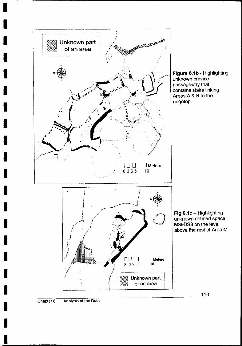
I I I I I I I I I I I I I I I I I I I I I
Unknown part of an area
~Meters 02.55 10
Unknown part of an area
Figure 6.1 b - Highlighting unknown crevice passageway that contains stairs linking Areas A & B to the ridgetop
Fig 6.1 c - Highlighting unknown defined space M39DS3 on the level above the rest of Area M
~~~ __ ~~ ____ ~ _________________________________ 113 Chapter 6 Analysis of the Data

I I I I I I I I I I I I I I I I I I I I I
There is a significant difference in the size, visibility and aesthetics between the
known and unknown areas of the site. The unknown areas (Areas F, E, Q and
P) are smaller, discrete locations that blend into their natural surroundings not
only as a result of their obscured aspect but also because of the texture of the
dry-stone walling. In these areas the walls are built using mostly unworked
stone. In addition, these areas each have an independent stairway link to the
ridgetop. In contrast, the known areas (Areas A & B, G and M) are all
accessed from the ridgetop via the prominent Central Stairway - the top of
which is located twenty metres to the northeast of the Sir Dudley de Chair
lookout (Figure 5.16), a place that attracted visitors even before Ricetti's arrival
(Figure 6.2). These known areas are highly visible, not only because of their
more exposed aspect but as a result of their comparatively numerous high and
long walls of worked stone and flush-finished faces. Figures 6.3a&b highlights
these prominent, visually impressive walls (Walls A1WRS A2.1WRS,
A2.2WRM, A3WRC, A4WR, A13WRCP, B1WRM, B2.1WR, B2.2WRl,
B29WRl, B30WRlM, BX2WF, BX4WR, B7WRM, B10WRC, 11.1WRC,
B11.2WRl, G6.1WRlM. G6.2WRlM, G10.1WRl, M2WFP, M3WFP, M4WRC,
M5WRC, M26WRC, MX1WRC).
Figure 6.2 - Visitors to the lookout at Scenic Hill -1928 Source: GCl
___________________________________________________ 114 Chapter 6 Analysis of the Data

I I I I I I I I I I I I I I I I I I I I I
.. Prominent Stone ..... >m ... ~"
Terrace
182. /
/ i
/~ i
I
IC\
~Meters o 2.5 5 10
I I
~IMeters 0'2.5 5 10
_ Prominent Stone Features
Terrace
Figure 6.3a -Highlighting the prominent walls in Areas A & B
Fig 6.3bHighlighting the prominent walls in Areas G and M
~~~~~~~~~ ______________________________ 115 Chapter 6 Analysis of the Data

I I I I I I I I I I I I I I I I I I I I I
Access Routes
There is a pattern of interlinking paths, stairways and entry/exit points within the
known areas of A & B (Figure 6.4c) and G, H, C and M (Figure 6.4d). In most
cases these access ways lead into one another with very few 'dead ends'.
There are multiple entry/exit points to the various parts of each area however
this pattern is especially noticeable for the enclosed defined spaces within each
area. Further, for each defined space these multiple entry/exit points have
different aspects and lead to multiple options of possible direction (Table 6.2
and Figures 6.4a-g).
Enclosed Entry I Exit Aspect to Possible Defined points Defined directions Space Space from exit F4DS1 F7E sw 3
From ledge above NE 1
E4DS2 E5E NE 2 E7E SW 1
A17DS4 A20E NE 2 A21E SE 2 A22E SW 2 A23E N 3
D1RB D2E NW 2 D3E SW 1 D4E SE 1
M34DS1 M44E NE 1 M39DS3 M28E SW 2
M29E NE 2 M30E SE 1
M41DS2 M42E NE 2 M30E NW 2
M48DS1 M51E SE 1 Q6DS1 Q7E NE 2 P13DS1 P11E NE 3
Table 6.2 - Multiple Entry/Exit Points to Defined Spaces
~~~ __ ~~~~~~ _______________________________ 116 Chapter 6 Analysis of the Data
I
I

I I I I I I I I I I I I I I I I I I I I I
There are several places where access from one part of an area to another is
achievable only by ladder or plank. A ladder would have been necessary to get to
the covered ledge 2800mm above F4D81 (Figure 6.4a), to the base of the stairs
(B408) 2000mm above ground level between the cavern area and B16T (Figure
6.4c), and to M39D83 4200mm above M41D82 via M30E (Figure 6.4d). A plank
would have been required to get across the gap between M4WRC and the circular
structure (M26WRC) (Figure 6.4d). This means of access is supported by oral
history that states Ricetti used ladders and planks to get around some places
(pers. comm. J. Bicego 4.8.2004; J. Bugno 5.8.2004; Ceccato 2001: 29). Indeed,
in archival photograph APH.M9 it is possible to see that Ricetti possessed a
commercial ladder, and in APH.M13 two more, possibly 'homemade' ladders can
be seen - as well as a plank crossing between M4WRC and M26WRC (Figure
6.7c). APH.x2 also depicts a 'homemade' ladder.
~ ________ ~ _______________________________________ 117 Chapter 6 Analysis of the Data

I I I I I I I I I I I I I I I I I I I I I
Defined Space
Possible direction from Entry/Exit Point
Ladder access
i i
Defined Space
Possible direction from Entry/Exit Point
Figure 6.4a - Area F -Access Ways
Figure 6.4b - Area E - Access Ways
~ __ ~ __ ~~~ __ ~ _______________________________ 118 Chapter 6 Analysis of the Data

I I I I I I I I I I I I I I I I I I I I I
Defined Space
~ Possible direction from Entry/Exit Point
Ladder access ~
/ ~", Pathway (intra-area)
•
( \
\, \
Figure 6.4c - Area A & B - Access Ways
ru-u--I Meters o 2.5 5 10
119 ~~~--~~~~-=~--------------------------------
Chapter 6 Analysis of the Data

I I I I I I I I I I I I I I I I I I I I I
~Meters 02.5 5 10
Figure 6.4d - Areas G, H, C and M - Access Ways
Defined Space
Possible direction from Entry/Exit Point
Ladder access
Pathway (intra-area)
---------
~~~~~~~~~ ______________________________ 120 Chapter 6 Analysis of the Data

I I I I I I I I I I I I I I I I I I I I
\ ~"'" Possible direction from ~ ~_EntrylExit Point
1Ll-2.5 5
()4E
-~Meters 10
JD3E ~
Figure 6.4e - Area D - Access Ways
Defined Space
Possible direction from ~ Entry/Exit Point
! i
i I
o 2.5 5 -lMetelS I 10 I
I
o
Defined Space
Possible direction from Entry/Exit Point
2.5 5
,/ /.
n··i~7 ... ,/ . . '
. . ,
Meters 10
) ! fl ~ ~
11
t ! i, I I
I
Figure 6.4f - Area Q - Access Ways
Figure 6.4g - Area P - Access Ways
=-__ ~ ____ ~ _____________________________________ 121 Chapter 6 Analysis of the Data
I ________________________________ ~

I I I I I i I I I I I I I I I I I I I I I
BUILT FEATURES AND CONSTRUCTION TECHNIQUES
There are patterns and similarities in the built features and construction
techniques across the various areas of the site. These trends are apparent in
the terracing, use of metal sheeting, cultivated vegetation, rock art, water
catchment systems, incorporation of natural features, and the functionality of
the walls.
Terracing
Areas A & B, G and M comprise several terraces (A10T, B12T, B13T, B14T,
B15T, B16T, B17T, G5T, M13T and M14T) which have been created by the
building of retaining walls and the backfilling and levelling of soil (Figures
6.5a&b). Pictorial evidence and the extant remnant vegetation, in the case of
Areas A & B and M, show that the terraces were cultivated with a variety of
edible and ornamental plants (Table 6.3) neatly set out in decorative patterns
with edged borders, fencing and trellising (refer to APH.B1, B15, M7 and M10
in Appendix 7). In Area C, the wire mesh (G9AFTMW) as well as the strands of
wire (G8AFTMW) embedded in the rock wall above the southwest corner of
terrace G5T were likely part of a trellising system and an indication that this
terrace too once contained plantings.
Metal Sheeting
Scraps of metal sheeting have been observed in Areas A & Band G embedded
in the ground running parallel to and against the foot of the following terrace
retaining walls: A2.2WRM, B1WRM, B30WRLM, B7WRM, B9WRM, G6.1 and
G6.2WRLM (Figures 6.5a&b). This metal sheeting is found to be consistently
on the uphill, terrace side of the wall and comprises scraps of flat (e.g. oil drum
lid) or intentionally flattened metal (e.g. bisected iron wash tub).
~~~ __ ~~~~~~ _____________________________ 122 Chapter 6 Analysis of the Data

I I I I I I I I I I I I I I I I I I I I I
_ Wall with Metal Sheeting
Terrace
I ... . -
'"
.. ~ -r'
I~: ~ ""~ A2,2WRM
flIlJ-'l Meters o 2.5 5 10
_ Wall with Metal Sheeting
I [=::::J Terrace -"--~ .-~--~.'
Figure 6.5a -Highlighting Terraces and Walls with Metal Sheeting in Areas A& B
Figure 6.5b -Highlighting Terraces and Walls with Metal Sheeting in Areas G & M
~~~ __ ~~~~~ _______________________________ 123 Chapter 6 Analysis of the Data

I I I I I I I I I I I I I' I I I I I, I I I
Cultivated Vegetation
The species of cultivated vegetation evidenced through archaeological, oral
history, documentary and/or archival photographs, and their probable use, is
set out in Table 6.3. With the exception of a stone-fruit tree (E11V) and an
olive tree (E12V) growing in the vicinity of Area E (Figure 5.3), all extant
remnant vegetation is growing within the various terraces of Areas A & B
and M. Other unidentified plants, no longer extant, are evidenced in archival
photographs.
Species of plant Use Evidence I Reference
Banana trees Edible (Ceccato 2001 :27), APH.M1, M2, M3, M5
Carnations Ornamental (Ceccato 2001 :27) Extant (Areas A, B and M), APH.B7, B11,
Dracaena Ornamental M7 Extant (Areas A, B and M), APH.B1, B5,
Fig trees Edible B15,B16,B17
Grape vines Edible / Shade Extant (Area B), APH.B6 (pers. comm. J. Bugno 5.8. 2005),
Lettuce, Radicchio Edible APH.B4
Oleander bush Ornamental Extant (Area M), APH.M4
Olive tree Edible Extant (Area E) Edible,
Passion fruit vines Ornamental, Shade (pers. comm. J. Bugno 5.8.2004), APH.M9
Rose bush Ornamental Extant (Area A) Stone-fruit trees (i.e. peach or apricot) Edible ExtantlAreas B and E)
Stocks Ornamental (pers. comm. P. Ceccato 5.8.2004)
Tomato plants Edible PSD#3
Sweet peas Ornamental The Area News 20.5.1977
'Vegetables' Edible The Area News 20.5.1977
Table 6.3 - Some of the species of exotic vegetation planted by Ricetti
~~~ __ ~~~~~~ _______________________________ 124 Chapter 6 Analysis of the Data

I I I I I I I I I I I I I ,I I I I I I I I
Rock Iconography
There are four instances of rock art that can be attributed to Ricetti, as set out
in Table 6.4. They are all found within spaces defined by built walls.
Featuie Type of art Depiction Position No.
Engraving Includes Ricetti's initials and an Within illegible date cavern area
836AFTE (Figure 5.101 above 816T
G12AFTP Painting Sacred iconography of crucifix, Within includes Ricetti's initials 'Chapel' (Figure 5.18) grotto
M33AFTP Painting Repetitive designs of 'daisies' and Within 'Main 'anchors' (Figures 5.23a&bj Cave'
P6AFTP Painting Geometric lines Within (Figure 5.27) P13DS1
Table 6.4 - Rock Iconography attributed to Valeri Ricetti
Water Catchment
There are three cisterns for retaining water, all in Areas A & 8 (Figure 6.6).
AX6C at the top of the gully (A29G) catches water runoff from the top half of the
large sloping surface of 861RP. Water runoff from the bottom half of 861RP
and also from A40R8 is channeled down the man-made continuation of A29G
and into A14C. Cistern 821C, at the foot of the cliff, catches water that funnels
down a natural crevice in the cliff face. In addition, Ricetti used a long piece of
galvanised drainpipe into which he would scoop rainwater from puddles that
collected in the natural depressions on the ridgetop, to be channelled into two
large oil drums positioned in the terraces below (Ceccato 2001 :29).
~~~ __ ~~~~~~ _______________________________ 125 Chapter 6 Analysis of the Data

I I I I I I I I I I I I I I I I I I I I I
Terrace
Cistern
Gully
Slope of rock face
..
., ..
~Meters o 2.5 5 10
Figure 6.6 - Highlighting water catchment cisterns and gully in Areas A & B
~~~ __ ~~~~ ________________________________ 126 Chapter 6 Analysis of the Data

I I I I I I I I I I I I I I I I I I I I I
Incorporation of Natural Features
The incorporation of natural elements of the landscape as part of the design of an
area is seen repeatedly throughout the HCC. The use of natural rock overhangs
as roofing, rock ledges as supports for added roofing material and the inclusion of
vertical faces of rock formations as 'walls' defining an enclosed space are some of
the ways in which Ricetti has taken advantage of natural features. Table 6.5 below
records the nature and location of this exploitation of natural features.
~ F E A&B D G H C M Q P T
Use of ...
... rock- Chapel Shelter
shelter as F4DS1 E4DS2 A17DS4 Area grotto over M34DS1
0 natural roofing seating ... rock ledges as support for M39DS3 P13DS1 'roofing' M48DS1 Q6DS1 over defined space ... sheerface of natural rock formation F4DS1 E4DS2 A17DS4 Area M39DS3 Q6DS1 P13DS1 as 'wall' to 0 M48DS1
an enclosed defined space ... rock formations A29G
for water A14C AX6C
collection 821C
... rock formation as
M48DS1 base of hearth
... hollow tree as Area T
chimney
Table 6.5 - Nature and location of incorporation of natural features
~~~ __ ~~~~~~ _______________________________ 127 Chapter 6 Analysis of the Data

I I I ·1 I I I I I I I I I I I I I I I I -I
'Non-Functional' Walls
Most of the walls that have been built have a solid functional basis, either to
retain terrace soil, prevent erosion, create pathways, enclose a sheltered space
or to channel and entrap water runoff. However, there are some walls where
superfluous effort has been invested for no clear functional advantage,
discussed by Area below. Whilst all walls do serve to define or divide space,
these walls do not appear to have any other functional purpose to their design.
AreaA& 8
B10WRC, B11.1WRL and B11.2WRL. Together these fortress-like buttress
walls form an excessively grand ramped access way where more easily-built
stone steps could have served the same purpose (Figures 6.7a&b).
Area M
M4WRC. Whilst this fortress-like segment of the retaining wall does serve to
retain the levelled ground in M14T, the continuation of a straight, less labour
intensive wall would have achieved the same outcome (Figures 6.7c&d).
M26WRC and MX1WRC. These walls serve no obvious 'functional' purpose.
Oral history states that Ricetti would stand on what he referred to as the 'gun
emplacement', accessed via M4WRC, (Figures 6.7c&d) looking east towards
the new Creamota wheat silos and the McWilliams wine storage tanks in the far
distance. The afternoon sun reflecting off the shiny metal, he would say, was
the enemy and that 'the Donna in Biancho (the woman in his vision) had told
him so, and to defend his Sacra Collina' (pers. comm. J.Bugno 19.5.2005).
~~~ __ ~~ __ ~~ _________________________________ 128 Chapter 6 Analysis of the Data
I

I I I I I I I I I I I I I I I I I I I I
Figure 6.7a - 'Non-functional' walls B10WRC, B11.1 and B11.2 WRL
~ _ 'Non-functional' Wa~ . . .
~Meters 02.55 10
Figure 6.7b - Location of 'non-functional' walls B10WRC, B11.1 and B11.2 WRL in AreaA& B
~~~ ____ ~~~=-_______________________________ 129 Chapter 6 Analysis of the Data

I I I I I I I I I I I I I I I I I I I I I
Figure 6.7c - 'Non-functional' walls M4WRC, M26WRC and MX1WRC Photograph dated: circa 1936 Source: GCl
~ ~Meters ~ 0 2.5 5 10 f ;
j I I ( " ! ~ Y
Figure 6.7d - location of 'non-functional' walls M4WRC, M26WRC and MX1WRC in Area M
6 Analysis of the Data 30

I I I I I I I I I I I I I I I I I I I I I
SITE EVOLUTION
Sequential building phases and modifications are evidenced in the following
walls: B2.1WR, G6.1WRLM, G10.1WRL and M9WFC (Table 6.6 below).
These different phases are evidenced as vertical or horizontal lines of abutment
in the stonework of a feature. They are also verified by comparison between
the nature of the extant feature and that seen in archival photographs. Whilst it
is possible to determine the sequence of change it is not possible to determine
the timeframe involved.
Feature Nature of Table 6.6 - Evidence of Site Evolution
Evolution
B2.1WR Recessed vertical line of
(Aspect: abutment Side on) showing
subsequent extension of the wall.
B2.1WR
(Aspect: Face on)
Continued ...
~ ______________ ~ _________________________________ 131 Chapter 6 Analysis of the Data

I I I I I I I I I I I I I I I I I I I I I
... continued ...
G6.1WRLM Horizontal lines in stonework indicating three phases of building.
G10.1WRL Two vertical lines of abutment indicating filling in of possible entranceway to 'Chapel' grotto.
----~--~~~~-=~--------------------------------Chapter 6 Analysis of the Data
... continued ...
132

I I I I I I I I I I I I I I I I I I I I I
M9WFC Extension of wall
Before
and
After
By matching up the white markings on the rock face above the entrance to the 'Main Cave' it can be seen that M9WFC (wall on left of opening) has been extended by about 800mm to reduce the width of the entrance way.
Source: (DaHon & Polkinghome 1990) Dated: 1936
Courtesy: Sam di Fiori Undated
Table 6.6 - Evidence of site evolution
33 Chapter

I I I I I I I I I I I I I I I I I I I I I
CULTURAL INFLUENCE
Cultural influences from Ricetti's formative years in Northern Italy can be seen in
various aspects of the site, such as the stonemasonry (Figures 6.8a&b); the
terracing of steep slopes to create cultivable land; the planting of grape vines and
fruit trees; the 'chapel' grotto with its painted crucifix; and the fortress-like
structures which would all appear to hark back to his childhood years growing up
in the region of Valtellina. This alpine valley of the upper Addo river is known for
its undulating, terraced vineyards and orchards, medieval fortifications and
staunch Roman Catholicism (Encyclopedia. corn 2005; Valtellina Direct Requests
2005). Even the painting of his initials in the 'Chapel', first as 'RV and then 'VR',
reflects the Italian tradition of writing the surname before the Christian name.
This cultural peculiarity is also seen in his signature in PSD11 and PSD15
(Appendix 1).
Figure 6.8a A typical stone wall farmhouse in Valtellina, Northern Italy Source:
01.02.2005
Figure 6.8b Stone wall structure in Area T. Photograph: Undated Courtesy: Pioneer Park Museum
~ __ ~ __ ~~ ____ ~ _________________________________ 134 Chapter 6 Analysis of the Data

I I I I I I I I' I I I I I I I I I I I I
SUMMARY
An analysis of the data has highlighted the patterns and trends that transcend
the various areas of the site. These characteristics have the potential to reveal
insights into Ricetti's behaviour and motivation through an expansion of the
interpretive model to include the phenomenological context. An interpretation
of these observations, based on a phenomenological approach, will be
discussed in the following chapter.
~ _________________________________________________ 135 Chapter 6 Analysis of the Data

I I I I I I I I I I I I I I I I I I I I
CHAPTER 7
DISCUSSION AND CONCLUSION
This chapter briefly recapitulates the contentious theoretical issues concerning a
phenomenological approach to cognitive archaeology before analysing the
cognitive processes expressed in the landscape of Valeri Ricetti. These
interpretations are then considered in relation to the theoretical issues under/ying
phenomenological archaeology, and the contribution that the present case study
makes to this issue is reviewed.
INTRODUCTION
The discussion of theoretical issues in Chapter 2 concluded that the major
criticisms directed against a post-processual phenomenological approach to
cognitive archaeology, is the perceived lack of any coherent theory of practice
and the paucity of rigour in the methods employed (Cleland 1988:15; Trigger
1989:29; Renfrew 1989:33; 1993:249). Consequently, such an approach to
cognitive archaeology may be no more than imaginative speculation as claimed
by defenders of a scientific approach such as Flannery & Marcus (1993:261) and
Renfew (1993:249; 1994: 11; 2001 :21). In addition, it has been suggested that a
cognitive approach is only feasible with the aid of direct historical association
(Flannery & Marcus 1998:36). The question is, then, to what extent can we trace
the cognitive processes of an individual through their archaeological remains?
The key issues that will be explored, based on the Hermit's Cave Complex, will
be an expression of motivational and behavioural processes. The data analysis
in Chapter 6 has highlighted several discernable patterns and observations in the
~ ____ ~~~ __ ~ __ ~ ____ ~~ __ ~~~ __ ~~~ __ ~~ __ 136 Chapter 7 Discussion and Conclusion

I I I I I I I I I I I I I I I I I I I I
archaeological remains concerning issues of location and layout, built features
and construction techniques, site evolution and cultural influence. These
patterns, in conjunction with the insights to Ricetti's character and behaviour
revealed through historical sources, discussed in Chapter 3, demonstrate certain
cognitive processes and character traits of Valeri Ricetti expressed through his
built landscape: that he valued his landscape along the ridgeline as a permanent
home with both physical and emotional investment; that he was capable of a
great degree of ingenuity and resourcefulness in constructing his built landscape;
and that his division of public and private space reflects a certain psychological
paranoia concerning his relationship to the wider context of Griffith and its
townspeople. Each of these themes will be discussed in turn below.
THEMES OF INTENTIONAL PERMANENCE
The idea of a hermit evokes notions of solitude, closeness to nature, a life of
study and contemplation as well as of an outcast, a person from another world,
with no possessions and a lifestyle that leaves little or no lasting trace of
existence (Colegate 2003:xii). Ricetti did live in virtual isolation in harmony with
his natural surroundings on which he focused his time and energy. He was
certainly regarded as 'eccentric to a marked degree' (PSD6; PSD14) and his
decision to self-recluse would indicate that he saw himself as a misfit in society.
However, far from being ephemeral, Ricetti has left a very definite and lasting
imprint of himself in the landscape he made his home.
The reason for Ricetti's choice to make Scenic Hill in particular his home is
revealed through the landscape itself. The distance from the town of Griffith
three kilometres away meant seclusion (Figure 4.9) and the many rocky outcrops
and rockshelters offered .protection from the elements. The surrounding
obscuring vegetation and the wooded slopes below provided natural camouflage
and privacy. The orientation of the cliffs and rock faces gave security from ~ __________________________________________________ 137 Chapter 7 Discussion and Conclusion

I I I I I I I I ,I I I' I I I I I I I I I
behind and an outlook over the Riverina Plain and the town of Griffith, while the
southeasterly aspect offered the first morning light and sunshine through till mid
afternoon. The existence of quarries in the vicinity (Figure 3.2), which he would
have heard blasting and crushing, was proof of the availability of good quality
stone. Fauna such as rabbits, pigeons and yabbies in the dam were a ready
food source. The farms in view below (Figure 4.7), with their fields of fruits and
vegetables (Griffith 2005), were also a convenient supply of food. With the
absence of a nearby creek or river, the dam in the pasture at the foot of the hill
(Figure 4.1), as well as the irrigation canals (Figure 3.1 b), promised a reliable
supply of water. Many aspects of the archaeological record demonstrate that
Ricetti's intention was to make this landscape his home on a permanent basis.
Building Material
Ricetti had a choice of building materials available to him. He had access to
earth for making mud bricks, timber from the wooded slopes of Scenic Hill,
corrugated iron and other scraps of metal sheeting from the nearby local dump
and also the prevailing outcrops of conglomerate and sandstone. Of the
materials available, stone is the most labour intensive and time consuming but
also the most durable. Ricetti's use of timber, such as in the doorjambs of the
structure in Area T (Figure 6.8b), window jambs evidenced in APH.x2, and
trellising and fencing, show that Ricetti had the capability of working with this
material. His decision to use stone is indicative of his aspiration to create an
enduring home. Using stone, a natural element of the surrounding landscape,
would also allow constructions with a low visibility impact. That stone was a
familiar material used in his native homeland and with which he was already
skilled would have given him the confidence to make this decision. The use of
larger square-cut end blocks of stone, the filling of gaps with smaller stones and
the flush-faced finish to the surface of the wall are some of the obvious technical
and structural similarities between Ricetti's style of building and that of a typical
farmhouse from Valtellina (Figure 6.8a).
~~-= __ ~ __ ~ __ ~ __ ~ ______________________________ 138 Chapter 7 Discussion and Conclusion

I I I I I' I I I I I I I I I I
Planning
Ricetti's construction of terraced gardens (in Areas A&B, G and M) is an exercise
related to long-term planning. The building of the walls themselves, the backfilling
and levelling of the terrace and the planting, watering and general maintenance
of the gardens are all aspects that had to be conceived, designed and planned,
for a result that would not reap benefits in the form of food source, aesthetic
value or shade and privacy for many months or even years.
In addition to the planning, a huge amount of time and labour has been invested
in the establishment of the gar~en terraces. The selection, transportation,
cutting and placing of thousands of cubic metres of stone has been involved in
the creation of retaining walls around the ten identified terraces (Figure 6.5a&b).
A total area of 505 square metres of terraced land had been backfilled to create
level ground in a sloping environment. The apparent fine, pebble-free nature of
the backfill soil in a stony environment is an indication that a process such as
sieving has occurred. The terraces were planted with a variety of edible and
ornamental plants indicating that they were intended for a practical as well as an
aesthetic purpose (Table 6.3). The planting of species, such as grape vines, fig,
olive, and stone-fruit trees, that do not fruit for several years, and require even
longer periods to reach maturity, would also indicate a long-term project.
Situated in a semi-arid region with low, infrequent rainfall and high summer
temperatures, combined with the poor retention properties of the soil, the non
native plants would have required consistent irrigation. Plants such as tomato,
passion-fruit vines, sweet-peas and lettuce would have required intensive care
and nurturing in the prevailing environmental conditions. Thus, Ricetti must have
planned and implemented a system for watering his gardens.
~~~ __ ~ __ ~ __ ~~~ _____________________________ 139 Chapter 7 Discussion and Conclusion

I I I I I I I I I I I I I I I 1 I 1 I "I
The metal lining between the terrace walls and terrace soil would have
maximised water retention, and the positioning of this lining has involved
obtaining, preparing and placing the scraps of metal sheeting prior to the
backfilling (Figures 6.5a&b). The fencing of the gardens and the trellising of the
various vines, as well as other general maintenance such as weeding and
pruning, are also aspects of cultivation that were planned and conducted in the
creation of the terraced gardens.
'Renovations'
The four observed occurrences of building phases or adaptations to the original
design of a wall are all located in the public spaces: Areas S, G and M (Table
6.6). These are perhaps in response to changes, such as the advent of 'tourism'
to the site. However, these renovations reflect an ongoing process of investment
of time, energy and presumably emotional attachment, which also testifies to the
perception of permanence.
Ownership
There are four instances of rock iconography attributed to Ricetti (Figures 5.10,
5.18, 5.23a&b and 5.27). In each case the iconography is found on rock
surfaces within areas that have been enclosed or surrounded by the building of
walls (Table 6.4). Two include Ricetti's initials. Knapp and Ashmore (1999:13)
have argued that 'identifiers' in the landscape, ranging diversely in form from
formal architectural structures to markings or natural features and even
intangibles such as oral links with significant events, can provide a focus by
which people engage with the world and create and maintain a sense of their
social identity. This marking of territory, by Ricetti, within places that have
already been demarcated by built features can be seen as a form of laying claim
and instilling a sense of ownership (whether consciously or SUb-consciously
intentioned). That Ricetti later approached the authorities to have 'Scenic Hill' ~~-= __ ~ __ ~ __ ~ __ ~ ______________________________ 140 Chapter 7 Discussion and Conclusion

I I I I I I I I I I I I I I I I I I I I
officially recognised and documented as his place of abode (PSD25) and that he
referred to the Hill as 'La mia sacra collina' (my sacred hill) (8ugno n.d.:23) and
saw its creation, maintenance and care as his 'mission in life' (PSD6) has
demonstrated his commitment and strong sense of belonging to this landscape.
The durable building material, the amount of time and energy devoted to the built
structures and their improvements, the extent of planning involved in the creation
of functioning cultivatable terraced land as well the obvious investment of
emotional attachment and ownership, show very distinctly that there was a
conscious intention and strong desire to make this place a permanent home.
THEMES OF INGENUITY AND RESOURCEFULNESS
The ability to build and maintain terraced gardens has already highlighted
Ricetti's ingenuity and resourcefulness. Other patterns in the archaeological
record express further evidence of this imaginative inventiveness and creativity.
Exploitation of Natural Features in the Landscape
In many instances Ricetti has incorporated his constructions within natural
features to achieve a functioning domesticated environment (Table 6.5). There
are six instances where naturally occurring rock-overhangs have been used as
shelters. Four of these (F4DS1, E4DS2, A17DS4 and M34DS1) have been
enhanced by the levelling of the ground beneath and by the addition of enclosing
walls to incorporate the rock-overhang as a natural roof to create an enclosed
and sheltered area. The remaining four enclosed areas (not including Area T for
which there is no material record) take advantage of natural ledges in the rock
face to support cross beams for added roofing (M39DS3, M48DS1, Q6DS1 and
P13DS 1). There are also numerous instances of sheer rock faces being
~~~~=-__ ~ __ ~ __ ~ _____________________________ 141 Chapter 7 Discussion and Conclusion

I I I I I I I I I I I I I I I I I I I I
incorporated as part of the walled enclosure as well as cases of built walls filling
gaps between rocks or extending natural rock features to complete an enclosure
(See, for example, Figures 5.24 and 5.28).
In the 'Kitchen' (M48DS 1), an impressive hearth has been fashioned out of the
natural rock formation, and a stone flue has been added (Figure 5.21a&b).
Area T comprised a hearth that was built such that an existing hollow tree was
incorporated as the flue (pers. comm. J.Bugno 5.8.2004; P.Ceccato 5.8.2004).
Area D defined by the natural formation of rock boulders with a spacious internal
cavity, and three access points conveniently located on different sides of the rock
formation, offers good visibility of Areas G, H and the base of Area C as well as
the linkway to Areas A & B. This area may have been exploited as a naturally
camouflaged 'hideout' (Figure 6.4e).
The high domed 'apse' and deep concave 'walls' of the 'Chapel' rockshelter,
formed by the natural weathering and erosion of kaolinitic layers, imparts an
innate cathedral-like ambience. In appearance, it resembles the ubiquitous
sacred grottos found in the countryside in Roman Catholic countries throughout
Europe. Bender (2001:1) has highlighted that, even for people who have always
lived in the same place, the sense of place and landscape extends out from the
locale and from the present encounter contingent upon a larger temporal and
spatial field of relationships. This concept of remembrance and evaluation based
on other times and places in Ricetti's past may well be evidenced in the painting
of a crucifix on the furthest recessed back 'wall', and supports the view that
Ricetti considered this shelter a sacred place.
Water-Management
Natural features have also been used for water-management. Given the dry
environmental conditions, the issue of water management is highly relevant to
~ __ -= __ ~ ____ ~~ ____________ ~~ ______ ~ __ ~~ ____ 142 Chapter 7 Discussion and Conclusion

I I I I I I I I I I I I I I I I I I I I
the intention of long-term settlement and the growing of thirsty non-native
vegetation. Though Ricetti made use of the livestock dam at the foot of the
slopes 230 metres below Areas M and G and the irrigation canal one and a half
kilometres away to the southeast (pers. comm. P. Ceccato 5.8.2004; J.Bugno
5.8.2004), this water supply was supplemented by the devising and
implementation of water management systems.
By taking advantage of gravity and the natural formations of the rock features,
Ricetti was able to control and preserve rainfall runoff through the creation of
sunken water storage cisterns (Figures 5.8 and 5.13). The three cisterns
observed in Areas A & B are conveniently located equidistant amongst the seven
terraces within this area (Figure 6.6).
The scraps of metal sheeting which line the uphill side of several terrace walls in
Areas A & Band G can be interpreted as a means to slow down the process of
water loss through the gaps between the stones of the retaining walls (Figures
5.9 and 6.5a&b). Although it is not possible to discern the depth of the metal
sheeting without excavation, it is probable that this 'waterproofing' extended
down as far as the difference between the ground levels on the upper and lower
sides of the retaining walls. It is likely that the clearing of obscuring vegetation
(in Areas A & B) and excavation would reveal evidence of metal lining on the
other terrace retaining walls in Areas A & B and in Area M.
It is a creative and imaginative mind that has the ability to visualise a rock face as
a potential interior wall of a room or that a long and narrow gap between two rock
platforms can be turned into a funnel for trapping water. Rather than being
undone by a difficult environment, Ricetti has incorporated the natural features
into his design in a process that Knapp and Ashmore (1999:13) have termed
'interanimation', the mutual moulding of the landscapes and the people who dwell
in them. The themes of ingenuity observed through the archaeological record
have demonstrated an inventive and highly creative mind at work. Whilst
~~-= __ ~ __ ~ __ ~ __ ~ ______________________________ 143 Chapter 7 Discussion and Conclusion

I I I I I I I I I I I I I I I I I I I I
Ricetti's ingenuity was acknowledged by the wider community who saw his work
as 'remarkable' (PSD4), this indisputable aspect of Ricetti's character stands in
contrast to the character portrayed in the official documentary evidence, as
discussed in Chapter 3, where he has been classified as 'insane' (PSD6) and a
'mental deficient' (PSD14).
THEMES OF PARANOIA
Ricetti had distinct, almost paradoxical, attitudes towards his private and public
worlds. It appears that he was willing to attract outsiders, and yet also wanted to
escape and protect himself from them. These trends have revealed a paranoid
obsession to control the access and movement of outsiders as well as his
physical means of escape.
Public and Private Areas
The pattern of known and unknown areas of the site can be seen to represent
public and private areas (Figure 6.1 a). The known areas of the site correspond
to the places to which Ricetti accepted and even encouraged visitors (Areas A &
8, G, H, C and M) and all but two (of Area T) of the extant archival photographs
have been taken in these areas. Several aspects of the site convey this desire.
That the grand Central Stairway was built only metres away from the Sir Dudley
de Chair Lookout, which people were already visiting, would suggest that this
was an open invitation to enter his domain (Figure 6.2). It is likely that the highly
visible, beautifully finished walls of the known areas were created to stand out
and be noticed (Figures 6.3a&b). Terraced gardens are found only in the known
areas (Figures 6.5a&b) and they contained not only practical, edible vegetation
but also ornamental, flowering plants aesthetically arranged in decorative rows
with neatly edged borders kept perfectly manicured (Table 6.3). This is another
~ _________________________________________________ 144 Chapter 7 Discussion and Conclusion

I I I I I I I I I I I I I I I I I I I I
indication that in these public areas one of the purposes of Ricetti's design was
to be observed, appreciated and admired by others. The investment of a great
deal of time and effort was necessary to achieve these results, suggesting that
this was an important personal issue.
On the other hand the unknown areas of the site can be seen as private areas to
which Ricetti could retreat and remain in obscurity when he so wished. These
areas are located not only on the extremities of the site but also interspersed
between and within the public areas (Figures 6.1 a,b&c). The intervisibility is
such that it is possible to observe all the public areas and their approaches from
some of the private areas without being observed in return (Figure 6.1a). For
example, Area Q has perfect visibility over Area M and yet is so well
camouflaged that not even the locals today knew of its existence. These vantage
points have been intentionally organised so that Ricetti would know when visitors
were present or approaching. In this way he could avoid being taken unawares
and could remain in control of whether he allowed himself to be seen or to
remain hidden in privacy. Interestingly, of the 51 extant archival photographs
taken at the Hermit's Cave Complex, 'The Hermit', the star attraction, appears in
only twelve (Appendix 7).
Control of Access
Distinct patterns of controlled access have been observed in the public areas of
the site (Figures 6.4c&d). These built paths and stairs offer easy access in an
otherwise difficult terrain. However, whilst guiding the visitor they were also a
means of defining and controlling movement around an area as well as limiting
entry and exit from the area to specific points. In Areas A & B the pathway
linking it with the Central Stairway arrives at the ramped access way B58E
(Figure 6.4c). In Areas G and H access is limited to G13E and G14E (Figure
6.4d), and in Area M public access is limited to M45E and M46E (Figure 6.4d).
These are designated access points, created by the building of paths, walls and
~ __ -= __ =-__________________________________________ 145 Chapter 7 Discussion and Conclusion
I

I I I I I I I I I I I I I I I I I I I I
stairways, and they are overlooked from obscure vantage points as discussed
above. If he desired, Ricetti would have been able to observe visitors to the
public areas without being observed himself.
Defence
In Area B, the buttress-like walls B10WRC, B11.1WRL and B11.2WRL, standing
up to 2500mm above the slope of the land below, form an impenetrable barrier
except through the ramp-like entrance way in the gap between them (Figure
6.7a&b). The 27 metre long fortress-like wall comprising M2WFP, M3WRP,
M4WRC and M5WRC, originally standing higher than the extant 2000mm,
stretches across the entire length of Area M, creating an imposing barricade to
the lower slopes and restricting access to the designated points at each end
(Figure 5.22). The protruding semi-circle of M4WRC increases the range of
'vision and allows a clear view along, and beyond, the walls on either side of it,
probably inspired by memories of the medieval fortifications of his cultural
background. The circular structure M26WRC and MX1WRC, referred to by
Ricetti as the 'gun emplacement' (though there was never a gun in place) and
accessed by a 'drawbridge' plank system (pers. comm. J. Bugno 16.5.2005)
(Figure 6.7c), is a further indication of an obsession with defence. These
fortification-type structures are within the public realm of the site and are well
constructed, highly visible, large and well known. If indeed these walls were a
notional 'defensive' structure, then they provided a means of letting the public
see his creations, but at the same time sending a very visible and familiar
message, through the fort-like architecture, that he valued his domain and his
privacy.
It has been proposed that the imagination can weave other concepts around a
place, triggered by mental images and evoked memories of other places or
events in a person's biography (whether real or encountered through hearsay or
myth). Further, these subjective perceptions of space, or conceptualised
~~~ __ ~ __ ~ __ ~ __ ~ ______________________________ 146 Chapter 7 Discussion and Conclusion
I

I I I I I I I I I I I I I I I I I I
i I
I \
landscapes, can be at odds with physical reality (Darvill 1999: 1 07; Knapp &
Ashmore 1999:13). The building of these (faux) fortification-type structures,
perhaps as a result of his auditory and visual hallucinations that called for him to
protect his 'sacred hill' from the enemy (pers. comm. J.Bugno 19.5.2005), are a
likely indication of Ricetti's individualised perception of the world around him.
Escape
Of the ten defined or enclosed and roofed spaces, six have more than one
entry/exit point and in some cases up to four (Table 6.2). These access points
have been created by steps or stairways or by incorporating natural
passageways between rocks, and in four instances access involved the use of a
ladder (which could also be removed to prevent unwanted access) (Figures
6.4a,c&d). In every case, each entry/exit point has a different aspect. Further,
there are multiple possible directions to arrive at or leave each entry/exit point,
including the defined spaces with only one entry/exit point (Figures 6.4a-d). This
would have made it possible to literally disappear or escape confrontation with
outsiders.
Ricetti's paranoid obsession with remaining elusive is expressed in his
landscape. Wanting to attract visitors to his domain and yet wanting to control
their access and movement to specific areas, being able to observe those places
from hidden vantage points, having hidden, private places to which he could
disappear and the myriad of planned escape routes allowed him to remain in
control of whether or not he had to confront people. These conflicting themes of
inclusion and exclusion are consistent with the nature of a person with paranoid
schizophrenia, with good days of feeling normal alternating with paranoid days of
fear, distrust and suspicion. The division between public and private areas in
the archaeological record, and the resulting physical elusiveness of Ricetti,
tallies with the accounts of unreliable stories, professed forgetfulness,
vagueness, misinformation and use of aliases in the historical record.
~~~ __ =-__ ~ __ ~~~ _____________________________ 147 Chapter 7 Discussion and Conclusion

I I I I I I ,I I I I I I I I I I I I I I.
These interpretations of Ricetti's cognitive processes have been based on a
post-processual phenomenological approach. Whilst this investigation has used
standard methods for data collection, the methodological difference has been the
use of analytical structures that have expanded the interpretive context to include
Ricetti's engagement with the world around him; the phenomenology of the
landscape. These unquantifiable experiential elements have included the
meanings and emotions as well as remembrances, evaluation and desire
invested in the landscape.
DISCUSSION OF THE THEORETICAL ISSUES
The inclusion of the metaphysical elements of perception, conception and
sensation as part of the interpretive context in a phenomenological approach is
what defines it from any other approach to archaeology. Though these factors
cannot be empirically found, they are undeniably a significant part of the
cognitive processes which determine behaviour and motivation. As Hodder
(1999:256) has argued, how people cognitively organise the world is inseparable
from how they interpret and engage with the world. However, as justified by
Thomas (2000:3) and Tilley (1994:11), the unquantifiable and ever changing
nature of the experiential context has contributed to making it difficult, and
possibly impractical and restrictive, to prescribe a set methodology.
As discussed in Chapter 2, the basic tenet of post-processualism is that all
material culture produced is shaped by mental processes and therefore cannot
be entirely understood within a functionalist framework (Leone 1982:743). Whilst
not abandoning standard archaeological data, such an approach recognises the
need to embrace cultural and contextual difference and includes analyses that go
beyond the surface to look at relationships that generate meaning. Further, this
approach understands that objects and meanings change according to the ~~~ __ =-__ ~ __ ~~ _______________________________ 148 Chapter 7 Discussion and Conclusion

I I I I I I I I I I I I I I I I
I I
I I I
circumstances of the subject (Shanks & Tilley 1989:3; Hodder 1999:256; Tilley
2000:78). The role of phenomenology is to allow an understanding of those
changing meanings through an understanding of the process of the formation of
subjects and how they perceive and understand themselves, their relationships
and the world (real or imagined) around them (Bender 1993a:257; Tilley
2000:78). These frameworks of meaning are not universal and cannot produce
generalisations; the same act conducted in two different contexts may not carry
the same significance (Hodder 1986: 118). As a consequence, though based on
rigorous procedures, contextually specific interpretations cannot be tested
through hypothetico-deductive-inductive methods that rely on model-based
understandings, as proposed by South (1977:15).
Despite the criticisms directed against a post-processual phenomenological
approach to cognition, an interpretation of the past that excludes the inter
relationship of people and the worlds that they have created for themselves to
live in ignores the totality of the evidence available and cannot be accepted as
being closer to the truth. In this case study, reading the archeology in isolation
from any other source of data may well have informed us of the differences in the
functional construction which in turn may have led to an interpretation of the
possible public and private areas. It may have been possible to pick up on the
fact that the separate areas are linked to one another and that certain areas are
intervisible, but only in one direction, However, without the historical sources, we
would not even have been able to attribute the site to a single individual. We
would not know of his biography, of his mental disorder, that he ran away from
people, that he had visions and heard voices, that he had a 'gun emplacement'
or that people went to only specific areas as testified by the archival
photographs. While it may have been possible to infer the basics, it would
indeed be no more than imaginative speculation, albeit educated guesswork
based on the material remains.
~~-= __ ~ __ ~ __ ~ __ ~ ______________________________ 149 Chapter 7 Discussion and Conclusion

I I I I I I I I I I I I I I I I I I I I I
Renfrew (1993:249) then is correct to say that a phenomenological approach to
cognitive archaeology can be seen as imaginative speculation, and Flannery and
Marcus (1998:36) are equally correct to say that the support of an adequate body
of historical association together with rigorous analysis is a way out of the
theoretical cUl-de-sac. However, just as Renfrew (1989:34) challenges such an
approach as adopting a 'past-as-wished-for', historical documents are no more
than a present-as-wished-for. Indeed, as Hodder (1986:119, 1991 :7) calls on
cognitive archeologists to appreciate the 'circles of context' that underlie every
individual's experience, the people of Griffith who remember Ricetti, who wrote
the newspaper articles and official documents, and who took the photographs,
were also viewing him from within their own separate experiences. As Colegate
(2003:xii) has highlighted, perceptions and attitudes towards hermits are inclined
to be stereotypical, a product of our own social constructs. Ricetti then is
inevitably documented in the historical record as a present-as-wished-for, or
ideal. This ideal has been perpetuated and exaggerated over the years as 'The
Hermit of Scenic Hill' has taken on a legendary status and become a symbol of
Griffith.
Renfrew (1994:6; 2001: 15) challenges a phenomenological approach as seeking
'to enter the minds of past individuals'. Clearly this is not possible, nor the
intention, in the same way that we cannot enter the mind of a person sitting next
to us on the bus, let alone someone separated by time, geography, and social
divides. However, the insights gained through a phenomenological approach;
the sense of permanence, the considerable ability and competence, and the
public and private areas, manifest in the archaeological record, all suggest a man
with a marked complexity of character. These insights not only SUbstantiate the
historical record, but in many ways give a greater understanding of the mental
processes of Valeri Ricetti than we would have otherwise known. Whilst these
interpretations are not made without the historical record, the archaeology has
allowed an understanding that goes well beyond the historical record. This
investigation has demonstrated that the expansion of the dialectic circle to
______________________________________________________ 150 Chapter 7 Discussion and Conclusion

I I I I I I I I I I I I I I I I I I I I I
include all known past experiences, including the phenomenological context, has
allowed a closer understanding of the internal meaning of Ricetti's landscape as
opposed to a surface knowledge of the archaeological remains.
FURTHER RESEARCH
This thesis has not covered the obvious heritage issues concerning the
conservation and preservation of the site. Other aspects that were not covered,
due to time and other constraints, but could be considered as possible avenues
for further research include transect walking to locate potentially unknown areas,
a proper analysis of the rock art and its symbolism, as well as an analysis of the
stonework and the method of building, sourcing, cutting and working of the raw
material.
CONCLUSION
At the beginning of the thesis, the question was posed: to what extent can we
trace the cognitive processes of an individual through their archaeological
remains? This investigation has demonstrated that, in regard to the Hermit's
Cave Complex, the answer is that we can learn a great deal about an individual's
behaviour and motivation based on their interaction with the landscape.
However, these interpretations are compromised by the necessity of direct
historical association. The historical sources have given voice to the
archaeology by allowing a more replete understanding of the emic context; how
Ricetti would have understood himself in the world, as advocated by Leone
(1982:742), Schuyler (1988/38) and Renfrew (1993:250). Nonetheless, the
archaeology has provided new and contrasting insights to Ricetti's behaviour and
motivation. The archaeology, as the manifestation of Ricetti's thoughts, has lent
an element of primacy to these insights.
~~-= __ ~ __ ~ __ ~ __ ~ ______________________________ 151 Chapter 7 Discussion and Conclusion

I I I I I I I I I I I I I I I I I I I I I
The implication is that cognitive archaeology can move beyond the explanatory
framework in which past ways of thought are understood through material
remains alone, towards an interpretive model which assesses the contextual
significance of phenomenology.
To date, there is a paucity of archaeological studies of individuals and, in this
respect alone, it is hoped that the current investigation can make a valuable
contribution. However, this thesis has contributed to the theoretical debate in
that it has shown that, despite the unquantifiable nature of phenomenology, it is
possible to show clear linkages between thought and action and to arrive at
grounded interpretations of the cognitive processes involved. These results
validate the arguments put forward by proponents of the post-processual
phenomenological approach to cognitive archaeology.
__________________________ ~ ________________________ 152 Chapter 7 Discussion and Conclusion

I I I I I I I I I I I I I I I I I I I I I
REFERENCES anon. 5.1.1977, "Hermit's Cave Vandalism", The Area News, pp. 1.
anon. 9.2.1977, "Cave Work Begins", The Area News.
Bender, B. 1993a, "Cognitive Archaeology & Cultural Materialism", Cambridge Archaeological Journal, vol. 3, no.2, pp. 257-60.
Bender, B. (Ed.) 1993b, Landscape, Politics and Perspectives, Berg Publishers, Oxford. .
Bender, B. 2001, 'Contested Landscapes: Landscapes of Movement and Exile', In (Eds, Bender, B. & Winer, M.), Contested Landscapes: Movement, Exile and Place Berg, Oxford & New York, pp. 1-20.
Bourdieu, P. 1977, Outline of a Theory of Practice, Cambridge University Press, Cambridge.
Brickhill, J. 1979 (Recipient: Mr R Giason, T. P. 0., Griffith, NSW) National Parks & Wildlife Service, Griffith District Office, Griffith, NSW. Official letter.
Bugno, J. n.d. Handwritten memoirs: Ricetti - "The Hermit", Griffith, pp. 1-23.
Burke, H. & Smith, C. 2004, The Archaeologist's Field Handbook, Alien & Unwin, Sydney.
Byatt, A. S. 1990, Possession: A Romance, Random House, London & Sydney.
Carson, J. 1973 (Recipient: Mr A Chittick, clo APEX, Box 846, Griffith) 4 Bodalla Road, Lake Munmorah, NSW. Letter.
Ceccato, P. P. 2001, From Broken Hill to Scenic Hill: The True Story and Part of Griffith's History: The Scenic Hill Hermit; Valerio Ricetti 1898-1952, Ultraprint, Griffith.
Children, G. & Nash, G. 1997, 'Establishing a Discourse: The Language of Landscape', In (Ed, Nash, G.), Semiotics of Landscape: Archaeology of Mind Vol. S661, Archaeopress, Oxford, pp. 1-4.
Chisholm, S. 13.4.2005, "Bid to Save Cave", The Area News, pp. 1-2.
Cleland, C. E. 1988, "Questions of Substance, Questions that Count", Historical Archaeology, vol. 22, no.1, pp. 13-17. .
Colegate, I. 2003, A Pelican in the Wilderness: hermits, solitaries and recluses, Harper Collins Publishers, London.
153 ~R~e~re-re-n-ce-s-----------------------------------------------

I I I I I I I I I I I I I I I I I I I I I
Dalton, H. & Polkinghorne, W. (Eds.) 1990, Griffith & District Pioneers: A Biographical Register, Griffith Genealogical and Historical Society Inc., Griffith.
Darvill, T. 1999, 'The historic environment, historic landscapes, and space-timeaction models in landscape archaeology', In (Eds, Ucko, P. J. & Layton, R.), The Archaeology and Anthropology of Landscape: Shaping your landscape Vol. 30, Routledge, London and New York, pp. 104-18.
Deagan, K. 1982, 'Avenues of Inquiry in Historical Archaeology', In (Ed, Schiffer, M.), Advances in Archaeological Method and TheoryVol. 5, Academic Press, Sydney, pp. 151-77.
Ellis, D. June 1996, "Most people said he was mad", Melbourne Agenda.
Encyclopedia.com 2005, 11.5.2005, <www.encyclopedia.com/html/v/valtelli.asp>.
Fenwick, W. H. 1.12.1989, "His Eden Blossomed on an Alien Hill", The Area News Weekender, pp. 7-8.
Flannery, K. V. & Marcus, J. 1993, "Cognitive Archaeology", Cambridge Archaeological Journal, vol. 3, no.2, pp. 260-70.
Flannery, K. V. & Marcus, J. 1998, 'Cognitive Archaeology', In (Ed, Whitley, D. S.), Reader in Archaeological Theory: Post-Processual and Cognitive Approaches Routledge, London and New York, pp. 35-48.
Gay, G. ca 1977, "APEX urges effort to restore Hermit's work", The Area News.
Geertz, C. 1993, 'Thick description: towards an interpretive theory of culture', In (Ed, Geertz, C.), The Interpretation of Cultures Fontana, pp. 3-30.
Griffith, C. C. 2005, Economic Development, Griffith City Council, 30.8.2005, <http://www.griffith.nsw.gov.au>.
Griffith Built & Natural Environment Group 2000, Scenic Hill: Plan of Management, Griffith City Council, Griffith.
Hampton-Adams, W. 1993, "Historical archaeology strove for maturity in the 1980s", Historical Archaeology, vol. 27, no.1, pp. 23-31.
Hodder, I. 1982, 'A Theoretical archaeology - a reactionary view', In (Ed, Hodder, I.), Symbolic and Structural Archaeology Cambridge University Press, Cambridge, pp. 1-17.
154 References

I I I I I I I I I I I I I I I I I I I I I
Hodder, I. 1986, Reading the Past: Current Approaches to Interpretation in Archaeology, Cambridge University Press, Cambridge.
Hodder, I. 1989, "Comments on Archaeology into the 1990s", Norwegian Archaeological Review, vol. 22, no.1, pp. 15-18.
Hodder, I. 1991, "Interpretive Archaeology and its Role", American Antiquity, vol. 56, no.1, pp. 7-18.
Hodder, I. 1993, "Social Cognition", Cambridge Archaeological Journal, vol. 3, no.2, pp. 253-7.
Hodder, I. 1999, The Archaeological Process: an introduction, Blackwell Publishers, Oxford.
Hoffman, A. 1996, 'Reliability and Validity in Oral History', In (Eds, Dunaway, D. K. & Baum, W. K.), Oral History: An interdisciplinary Anthology AltaMira Press, Walnut Creek, New York, Oxford, pp. 87-93.
Horder, T. n.d., "Rebuilding the Hermit's Staircase", The Area News.
Kelly, B. M. 1988, From Wilderness to Eden: A History of the City of Griffith its Region and its People, Council of the City of Griffith, Griffith.
Knapp, A. B. & Ashmore, W. 1999, 'Archaeological Landscapes: Constructed, Conceptualized, Ideational', In (Eds, Ashmore, W. &Knapp, A. B.), Archaeologies of Landscape Blackwell Publishers, Oxford.
Leone, M. P. 1982, "Some Opinions about Recovering Mind", American Antiquity, vol. 47, no.4, pp. 742-60.
Leone, M. P.1988, "The Relationship Between Archaeological Data and the Documentary Record: 18th Century Gardens in Annapolis, Maryland", Historical Archaeology, vol. 22, no.1, pp. 29-35.
Lloyd, S. M. 2000 Heritage Assessment "The Hermit's Cave" and garden complex, Scenic Hill, Griffith NSW State Heritage, Griffith.
Lowenstein, W. 1989, Weevils in the Flour, Hyland House, Melbourne.
Moreland, J. 2001, Archaeology and Text, Duckworth & Co Ltd, London.
Orser, C. E. 1996, A Historical Archaeology of the Modem World, Plenum Press, New York and London.
Palmer, G. R. 1984 An Aboriginal Archaeological Site Survey of a Proposed Reservoir Site at Griffith, NSW, Public Works Department, NSW, Griffith.
155 ~R~e~fu-ffi-n-ce-s-----------------------------------------------

I I I I I I I I I I I I I I I I I I I I I
Polkinghorne, W. 2004, The City of Griffith, Murrumbidgee Irrigation Area, Griffith Genealogical & Historical Society Inc, 10107/2004, <http://users.dragnet.com.au/-ggahs/abgriffith.htm>.
Rathje, W. 2001, 'Integrated archaeology: a garbage paradigm', In (Eds, Buchli, V. & Lucas, G.), Archaeologies of the Contemporary Past Routledge, London and New York, pp. 62-76.
Renfrew, C. 1989, "Comments on Archaeology into the 1990s", NOlWegian Archaeological Review, vol. 22, no.1, pp. 33-41.
Renfrew, C. 1993, "Cognitive Archaeology: Some Thoughts on the Archaeology of Thought", Cambridge Archaeological Journal, vol. 3, no.2, pp. 248-50.
Renfrew, C. 1994, 'Towards a cognitive archaeology', In (Eds, Renfrew, C. & Zubrow, E. B. W.), The ancient mind: Elements of cognitive archaeology Cambridge University Press, Cambridge, pp. 3-12.
Renfrew, C. 2001, "From social to cognitive archaeology: An interview with Colin Renfrew", Journal of Social Archaeology, vol. 1, no.1, pp. 13-34.
Renfrew, C. & Bahn, P. 2000, Archaeology: Theories, Methods and Practice, Thames & Hudson, London.
Renfrew, C. & Zubrow, E. B. W. (Eds.) 1994, The ancient mind: Elements of cognitive archaeology, Cambridge University Press, Cambridge.
Rubertone, P. E. 1989, "Landscape as Artifact: Comments on "The Archaeological Use of Landscape Treatment in Social, Economic and Ideological Analysis"", Historical Archaeology, vol. 23, no.1, pp. 50-4.
Schuyler, R. L. 1978, 'The Spoken Word, the Written Word, Observed Behavior and Preserved Behavior: The Contexts Available to the Archaeologist', In (Ed, Schuyler, R. L.), Historical Archaeology: A Guide to Substantive and Theoretical Contributions Baywood Publishing Company, Inc, New York, pp. 269-77.
Schuyler, R. L. 1988, "Archaeological Remains, Documents, and Anthropology: a Call for a New Culture History", Historical Archaeology, vol. 22, no.1, pp. 36-42.
Shanks, M. & Tilley, C. 1987a, Re-Constructing Archaeology, Cambridge University Press, Cambridge.
Shanks, M. & Tilley, C. 1987b, Social Theory and Archaeology, Polity Press, Cambridge.
References 156

I I I I I I I I I I I I I I I I I I I I I
Shanks, M. & Tilley, C. 1989, "Archaeology into the 1990s", Norwegian Archaeological Review, vo!. 22, no.1, pp. 1-12.
South, S. A. 1977, Method and Theory in Historical Archaeology, Academic Press, New York.
Sutton, M. 7.9.1988 In The Area News Griffith, pp. 16.
Thomas, J. 2000, 'Introduction: the polarities of post-processual archaeology', In (Ed, Thomas, J.), Interpretive Archaeology Leicester University Press, London and New York, pp. 1-18.
Tilley, C. 1993, 'Art, Architecture, Landscape [Neolithic Sweden]', In (Ed, Bender, B.), Landscape: Politics and Perspectives Berg Publishers, Oxford, pp. 49-84.
Tilley, C. 1994, A Phenomenology of Landscape: places, paths and monuments, Berg, Oxford & Providence, USW.
Tilley, C. 2000, 'Materialism and an Archaeology of Dissonance', In (Ed, Thomas, J.), Interpretive Archaeology Leicester University Press, London and New York, pp. 71-80.
Trigger, B. G. 1989, "Comments on archaeology into the 1990s", Norwegian Archaeological Review, vo!. 22, no.1, pp. 28-31.
Valtellina-Direct-Requests 2005, 1/02/2005, <http://www.valtellinaonline.com>.
Water Conservation and Irrigation Commission. 1923, Map of Town of Griffith and Environs, Parish of Jondaryan, County of Cooper, Wade Shire, Central Division N.S. W., Water Conservation and Irrigation Commission.
Welch, K. R. 2002, 'The History of Joseph Johns and an Examination of the Potential for Archaeological Excavations on the Site of his Former Residence', unpublished Honours Thesis, University of Pennsylvania,
Whitley, D. S. (Ed.) 1998, Reader in Archaeological Theory: Post-Processual and Cognitive Approaches, Routledge, London and New York.
Wood, W. R. 1990, 'Ethnohistory and Historical Method', In (Ed, Schiffer, M. B.), Archaeological Method and Theory Vo!. 2, University of Arizona Press, Tucson, pp. 81-109.
Yamin, R. & Methany, K. B. 1996, Landscape Archaeology: Reading and Interpreting the American Historical Landscape, University of Tennessee Press, Knoxville.
157 ~R~ef~e-re-nc-e-s----------------------------~-----------------