i made this map and it might give you a basic idea. it is ...godsofthemachine.com/spt-pdf/kiss...
TRANSCRIPT

I made this map and it might give you a basic idea. It is just a quick mock up so not totally accurate.
Of course you want to use visual aides as much as possible - landmarks, roads, crop circles.
You may need to y higher to pick up the stations sometimes.
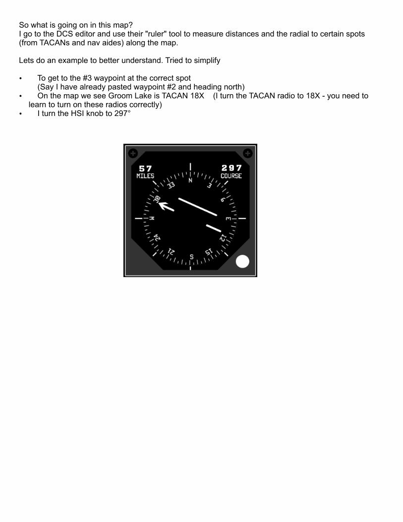
So what is going on in this map?I go to the DCS editor and use their "ruler" tool to measure distances and the radial to certain spots (from TACANs and nav aides) along the map.
Lets do an example to better understand. Tried to simplify
Ÿ To get to the #3 waypoint at the correct spot (Say I have already pasted waypoint #2 and heading north)
Ÿ On the map we see Groom Lake is TACAN 18X (I turn the TACAN radio to 18X - you need to learn to turn on these radios correctly)
Ÿ I turn the HSI knob to 297°

Ÿ Note the box I put on the map: 297° 46NM(only TACANs give distance the other nav aides do not. )In DCS world anyways
Ÿ Ok so I am ying somewhat north (I made it exactly north here for easier understanding) from waypoint #2
Ÿ The HSI needle is pointing in the direct of the point not the direct I want to y.I want to end up at
Ÿ The middle part of the arrow line is telling me the how far and to what side of that radial I am off.
Ÿ Fly until you see the arrow part of the needle and the middle part of the line match - Chase that
46nm297°

Another way to think about it is that the point you are trying to reach is in the middle of that center “Needle”
Here I am right at the point I am looking for.
Here I am past the point I am looking for.
Here I am heading for the point.

So hopefully to answer 1st question: "but where did the 297”Think of that TACAN as having a big circle around it with degrees. 360 degrees is a full circle. With north being 0°. The "Radial”
So when I arrived at waypoint 3 and I am ying north - if I was to look at the TACAN I would be looking left and my head would be turn to 297° if I had a big circle around my head.See how the line passes through the TACAN at 297°Like this:

The HSI looks like this at that point:
To dial in that 297 "Radial" in the HSI you turn the "CRS" knob #6 in the picture below until the #2 window reads 297:
The thing to remember is when that center line is to the right or left of the arrow line you want to chase it.If center line is to the right as in the example from my 1st post keep ying towards it.
If it was to the left of that line that means you past it in that example.
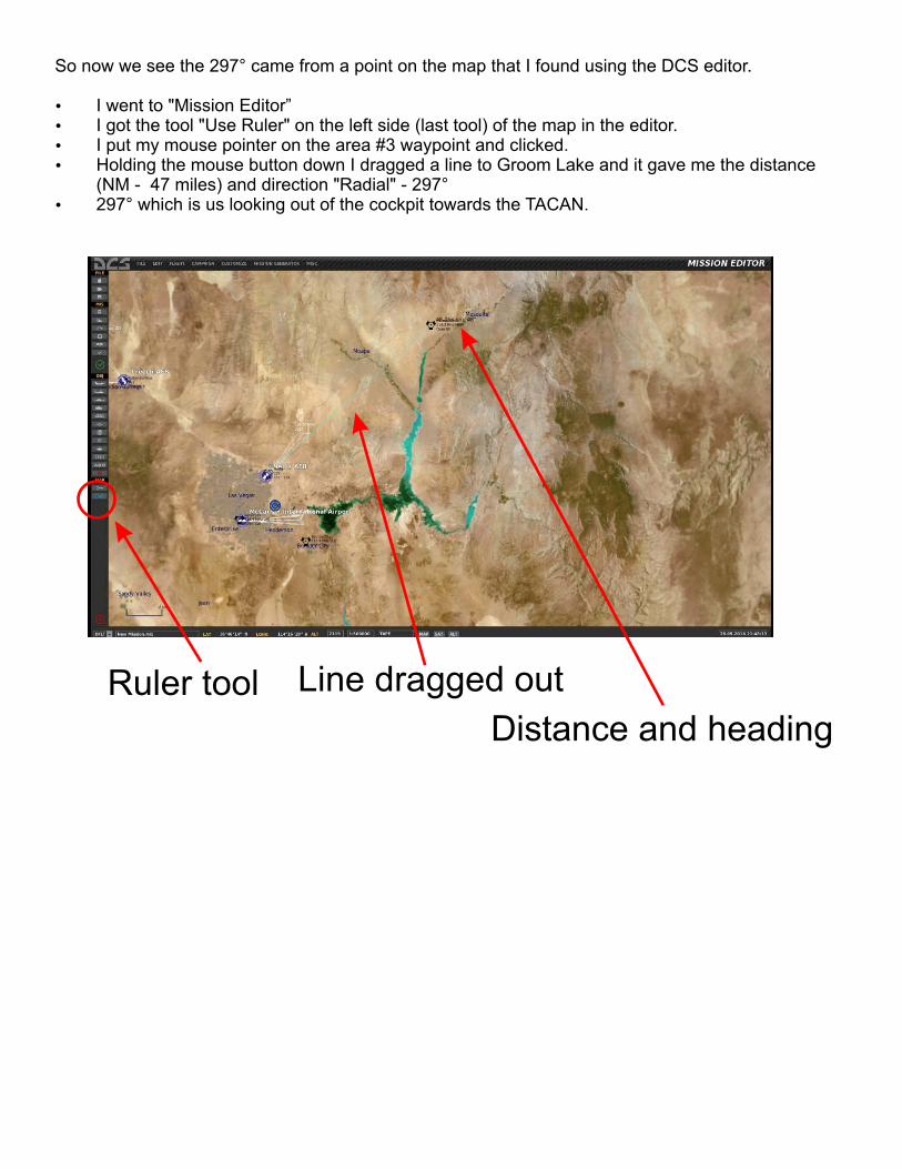
So now we see the 297° came from a point on the map that I found using the DCS editor.
Ÿ I went to "Mission Editor”Ÿ I got the tool "Use Ruler" on the left side (last tool) of the map in the editor.Ÿ I put my mouse pointer on the area #3 waypoint and clicked.Ÿ Holding the mouse button down I dragged a line to Groom Lake and it gave me the distance
(NM - 47 miles) and direction "Radial" - 297°Ÿ 297° which is us looking out of the cockpit towards the TACAN.
Ruler tool Line dragged out
Distance and heading

Let's start easy at the airport.
You can just use the mission editor and place your F-5 for a "Ramp Start". You call the ATC and ask for taxi he is going to send you to Runway 3 Again we think of the direction or Radial as the direct we are looking. So runways are setup for the direction we look at the start or end (land) depending which way we are looking. Looking to take off we want to look in the direction of 030. Time the ATC calls you to taxi to the runway (or if you already know) set your HSI to that direction. That way you get a visual idea of the runway direction. (I see all of the time in multi player guys taking off in wrong direction...sigh)
Here is the Airport:I circled the runway numbers. They leave off the zeros (just to confuse the nuggets)

Here it is simpler.
Runway 3
Runway 21
ATC: runway 3
The direction you are looking
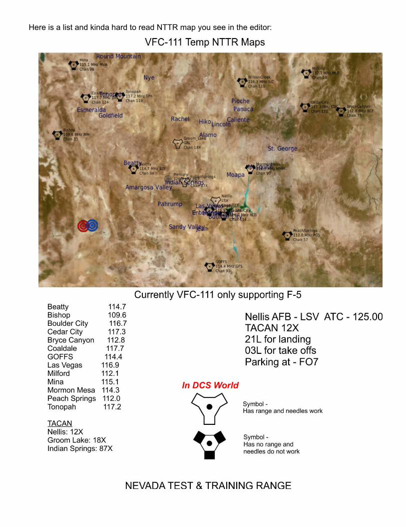
Here is a list and kinda hard to read NTTR map you see in the editor:
In DCS World

Ok we have taken off and are ying the same heading of the runway.
Run
way

Now lets y to another navaid. Lets head for Mormon Mesa 114.3 - Should be somewhat straight ahead after you take off.Since it is not a TACAN you need to congure your radios to pick it up. Radio setup on next page*Tip - It is good to have the radios set before you take off it makes it easier.Now since there is no range or working "Needles" on other navaids you need to use the little arrow on the outside of the HSI compass. #13
That little arrow will be a good friend for using on all of the other navaids on the map that are not TACANs.So radios all set and the little arrow pointing to Mormon Mesa 114.3 just y towards the direction the little arrow is pointing.HSI should somewhat look like this:
See no more range and the "Needles" just park themselves and are useless at this point. Use the little arrow on the outside.You know you have reached Mormon Mesa 114.3 when the little arrow becomes harder and harder to keep pointed in the right direction since you are so close.When you pass Mormon Mesa 114.3 the little arrow will twirl around and be behind you.Then we want to turn around and go back to the airport - NellisFinding Nellis and getting lined up for the runway is much easier since it is a TACAN and you will get range information and the "Needles" work again to get you lined up correctly.
Little Arrow
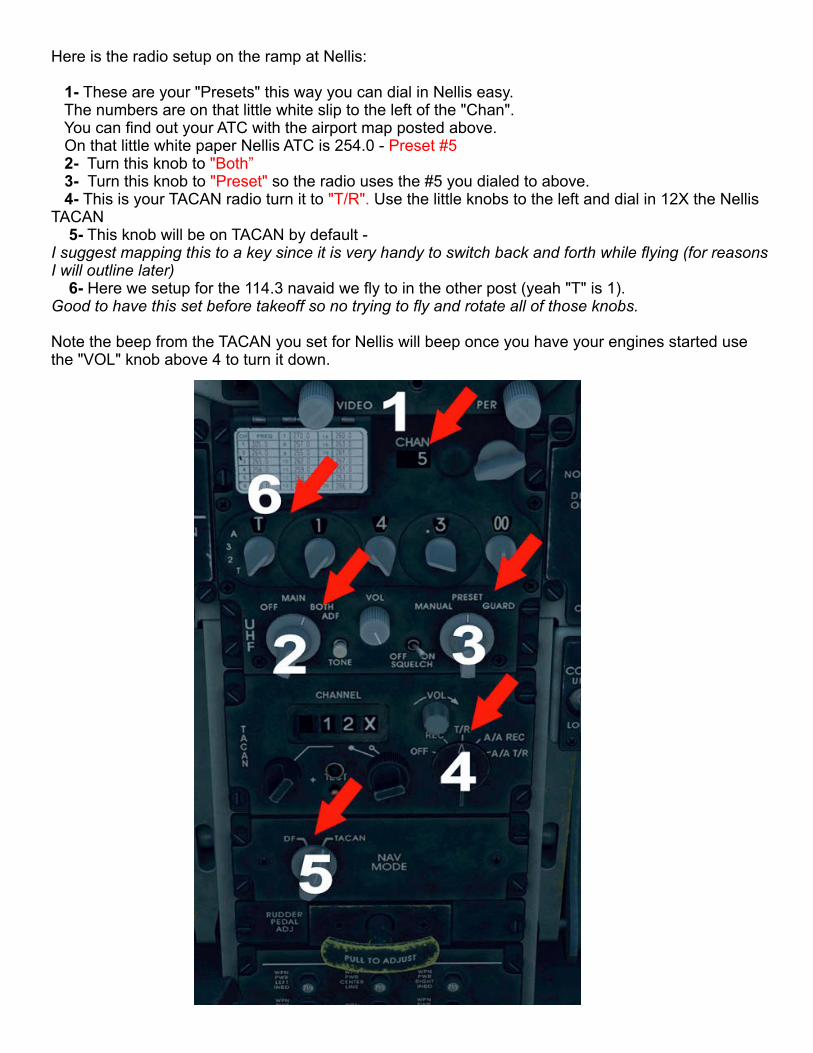
Here is the radio setup on the ramp at Nellis:
1- These are your "Presets" this way you can dial in Nellis easy. The numbers are on that little white slip to the left of the "Chan". You can nd out your ATC with the airport map posted above. On that little white paper Nellis ATC is 254.0 - Preset #5 2- Turn this knob to "Both” 3- Turn this knob to so the radio uses the #5 you dialed to above."Preset" 4- This is your TACAN radio turn it to Use the little knobs to the left and dial in 12X the Nellis "T/R".TACAN 5- This knob will be on TACAN by default - I suggest mapping this to a key since it is very handy to switch back and forth while ying (for reasons I will outline later) 6- Here we setup for the 114.3 navaid we y to in the other post (yeah "T" is 1). Good to have this set before takeoff so no trying to y and rotate all of those knobs.
Note the beep from the TACAN you set for Nellis will beep once you have your engines started use the "VOL" knob above 4 to turn it down.

Ok so you have been cleared by ATC to - TaxiYou have taxied to the active runway #3You asked for permission to Take off before entering the runway - ATC at the moment is not working so it is redundant but you can follow procedures.(Will help in multiplayer)You are lined up with your HSI set to 030 as outlined in and earlier post aboveYou take off
Now you switch to the Navaid 114.3 you setup at the ramp and here is how:
1- So here you have already got your radio set 114.3 2- Turn this to ADF - To pick up that navaid (Automatic Direction Finder) 3- Switch this off of to you are just telling it to use that 114.3 setting not the Nellis ATC"Preset" "Manual" 4- Switch this knob to (Direct Finder)"DF"

Your sight picture:
Now the range and the "Needles" not pointing to the navaid but you can still use the "Needles" to point at it by spinning the just to give you a quick reference."CRS"
So remember how I said mapping the knob that says "DF" and "TACAN" could help?You can now use it to do quick checks back to Nellis TACAN.Without switching any other knobs just turn it to (from "DF") and the HSI (Needles and little "TACAN" arrow) will now point back to Nellis and give you range information - the little arrow will rotate around behind you and point to Nellis too.One more quick turn from back to and the little arrow now points back to the navaid 114.3."TACAN" "DF"This is great for using two navaids and getting a general idea where you are.I usually keep the Groom Lake TACAN (18X) dialed in and do quick checks to see where it is (since it sits in the middle of the map) while ying.
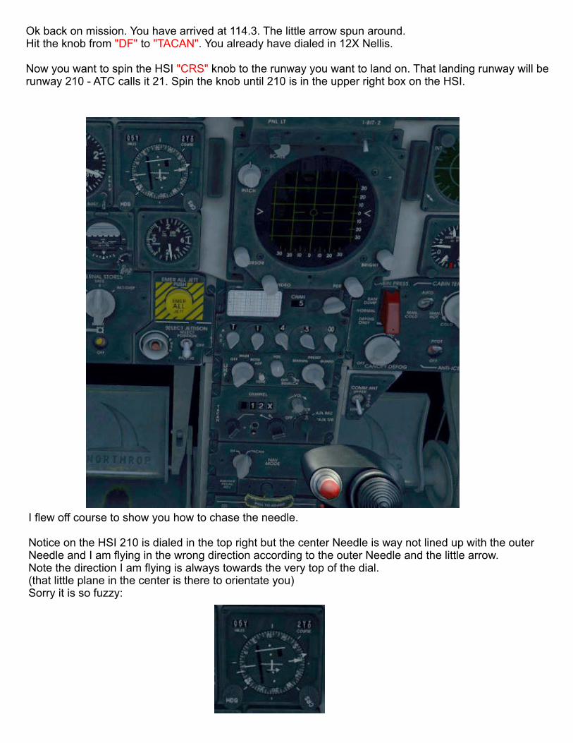
Ok back on mission. You have arrived at 114.3. The little arrow spun around.Hit the knob from to . You already have dialed in 12X Nellis."DF" "TACAN"
Now you want to spin the HSI knob to the runway you want to land on. That landing runway will be "CRS"runway 210 - ATC calls it 21. Spin the knob until 210 is in the upper right box on the HSI.
I ew off course to show you how to chase the needle.
Notice on the HSI 210 is dialed in the top right but the center Needle is way not lined up with the outer Needle and I am ying in the wrong direction according to the outer Needle and the little arrow.Note the direction I am ying is always towards the very top of the dial.(that little plane in the center is there to orientate you)Sorry it is so fuzzy:

So I want to keep chasing that middle needle in the direction I am going. When the center line is in line with the outer needle I turn right and follow the lined up "Needles" directly to the runway.By having the center Needle and the outer Needle lined up I know now I am centered up for the runway.
Sight picture: (see how the center Needle is a little right of the outer Needle - That is why I am ying a little to the right - chasing the center Needle
Have fun and try ying from 114.3 to 116.3then y back to 114.3 - go to 12X and land.....after you get a better idea of how this works

Since we are using only the TACAN 12X now we can put our top radios back to contact the ATC....and turn up that "VOL" knob again to hear them.
Sight picture:
Turn this back to "Both” Turn this back to "Preset”
Notice how the HSI now shows the distance, The "Needles" line up, and we have 210 set.