i e n c e : rese journal of marine science research ... · journal of marine science research...
TRANSCRIPT

Research Article Open AccessOpen AccessResearch Article
Journal of Marine Science: Research & DevelopmentJourna
l of M
arin
e Sc
ience: Research& Development
ISSN: 2155-9910
Durogbitan, J Marine Sci Res Dev 2016, 6:3 DOI: 10.4172/2155-9910.1000193
Volume 6 • Issue 3 • 1000193J Marine Sci Res DevISSN: 2155-9910 JMSRD, an open access journal
A Re-evaluation of the Depositional Environments and Sedimentary Facies of Middle Miocene Paralic Deposits (Agbada Formation), Ewan and Oloye Fields, Northwestern Niger DeltaDurogbitan A Abimbola*
Petrfac IES, Research and Development, Manchester, UK
AbstractThis study analyses depositional environments and facies of the middle Miocene (Agbada Formation),
northwestern Niger delta, based on cores and well log data, and incorporating ichonological data, that has led to a revision and re-evaluation of the facies within the study area. Log motif analysis, calibrated by lithology descriptions based on core photos, was used to define log facies associations and to identify stacking patterns and key surfaces. Six main wireline log facies associations have been recognized using gamma ray log motifs calibrated with core.
Within the cored interval two lithofacies associations have also been identified, based on composition, colour, sedimentary structures, and ichnofabric. They are: slope channel sand and shoreface sequences. The interpreted depositional facies model suggests an extensive development of marine dominated slope channel fill and shoreface deposits in the northwestern part of the delta. This suggests that in the studied area, the coastal barrier complex contains a large amount of sand that was originally deposited in river mouth bars, but was laterally removed by longshore current and re-deposited on the shoreline margin and basin ward through developed of canyons on the slope which serves as feeders and conducts for slope and basin fans.
The descriptive framework for the ichnofabrics analysis is based on bioturbation index (degree of bioturbation), burrow size, burrow frequency and ichonological diversity. Six ichnofabrics are recognized within the core namely: Planolites-Teichnichnus, Planolites-Phoebichnus, Planolites, Planolites-Thalassinoides, Teichichnus-Phoebichnus-Planolites and Palaeophycus-Planolites ichnofabrics. Observed tiering patterns are both simple and complex, which may reflect gradual aggradation or degradation of the substrate leading to overprinting as a stable ichnofauna structure develops. This type of tiering arrangement indicates a stable environment. The ichnofabrics are named after the dominant trace observed. Sedimentological analyses indicated that the depositional environments range from inner shelf to offshore.
*Corresponding author: Durogbitan A Abimbola, Principal Geoscientist, PetrfacIES, Research and Development, Manchester, UK, Tel: +447545822428; E-mail:[email protected]
Received May 04, 2016; Accepted May 24, 2016; Published May 31, 2016
Citation: Durogbitan AA (2016) A Re-evaluation of the Depositional Environments and Sedimentary Facies of Middle Miocene Paralic Deposits (Agbada Formation), Ewan and Oloye Fields, Northwestern Niger Delta. J Marine Sci Res Dev 6: 193. doi:10.4172/2155-9910.1000193
Copyright: © 2016 Durogbitan AA. This is an open-access article distributed under the terms of the Creative Commons Attribution License, which permits unrestricted use, distribution, and reproduction in any medium, provided the original author and source are credited.
Keywords: Niger delta; Miocene; Depositional environments;Lithofacies
IntroductionThe Niger delta is an example of a mixed wave, tide and fluvial
deltaic system [1]. It has long been recognised that deposits within the Miocene Agbada Formation of the Niger delta represent a prograding fluvial-deltaic depositional system intercalated by regionally extensive marine mudstone [1-5]. Sandstone units within the formation consist of fluvial (channel) or fluvio-marine (barrier bar), tidal channel and shoreface facies. Mineralogically, they consist of quartz with traces of feldspar, glauconite and zircon. Mudstones are generally fluvio-marine or lagoonal facies. The clay minerals are mainly mixtures of kaolinite, smectite and illites with some traces of pyrite, feldspar and carbonate [6] (Figure 1).
The reservoir intervals within the Agbada Formation have also been interpreted and documented to be deposited as highstand system tracts and transgressive system tract in a shelf delta setting [4]. The thickness of the reservoir intervals ranges from 45 feet to >150 feet. Most of the reservoirs observed within the shallow marine paralic section (Agbada Formation) have been described as point bars of a distributary channels, tidal channel fills, coastal barrier bars and shoreface deposits [2,7-11].
Aims and ObjectivesThe aims and objectives of the work were to re-evaluate the
depositional environments and facies scheme which had been originally outlined by the previous authors by incorporating ichonological
descriptions. This in turn will help to identifying the depositional conditions under which the sediment were deposited and preserved.
Data and MethodsIn this study, well log analysis (gamma, density, neutron log
etc.) and detailed core sedimentological descriptions, based on examination of core photographs have been undertaken, incorporating an ichonological description, constrained by seismic section. Log motif analysis, calibrated by core photographs and constrained with seismic were used to defining log facies associations which were used to identifying stacking patterns and key stratal surfaces.
Core sedimentology
The sedimentological descriptions from two wells, Ewan 1 and Oloye 3 (Figure 2) focused on the lithology, colour, grain size,

Citation: Durogbitan AA (2016) A Re-evaluation of the Depositional Environments and Sedimentary Facies of Middle Miocene Paralic Deposits (Agbada Formation), Ewan and Oloye Fields, Northwestern Niger Delta. J Marine Sci Res Dev 6: 193. doi:10.4172/2155-9910.1000193
Page 2 of 23
Volume 6 • Issue 3 • 1000193J Marine Sci Res DevISSN: 2155-9910 JMSRD, an open access journal
Figure 1: Landsat Thematic Images of Niger Delta illustrating the mixed wave, tide and fluvial influence on the delta [1].
BARRIER ISLANDS&
LAGOONS
WAVE-MODIFIEDCOAST
TIDE & WAVE-MODIFIED COAST
TIDAL ESTUARIES
50 Kilometers 0
N A
F
Figure 1: Landsat Thematic Images of Niger Delta illustrating the mixed wave, tide and fluvial influence on the delta [1].
• Mudstone (MS2) - laminated mudstone (indurated): This lithofacies is characterized as being an indurated, light greyish mudstone with rare streaks of sand or silt bands (Figure 4). Laminations in the mudstone are not distinct as in case of MS1, this may be due to their cohesiveness caused by the increase in the amount of clay minerals or different clay in mineral type or increases in water depth. This facies is observed in both Ewan 1 and Oloye 3 with thickness of about 0.3 m. The streaks of sand have indistinct small scales cross lamination, possibly rippled, suggest episodic energy. The carbonaceous materials also suggest terrestrial input. In this lithofacies, a Planolites ichnofabric is recognised, with small burrows. The dominance of mudstones suggests low energy, with periodic higher energy condition and input of this, sometime rippled sandstone lenses. The ichnofabric suggests environmental stress possibly caused by above terrestrial and fresh water incursion. This lithofacies is thought to have been deposited in deltaic lower shoreface sequences.
• Mudstone (MS3) - with lenticular bedded sandstones: This facies is composed of bioturbated, lenticular bedded sandstones, carbonaceous rich mudstones. Synaeresis? desiccation cracks are observed (shrinkage crack). A Planolites ichnofabric is identified, and the burrows are elongate and aligned parallel with bedding. The lenticular bedding is defined by thin bands of sandstones. The thin bedded sandstones exhibit mm-scale ripples lamination (Figure 5).
This type of facies is only observed in Oloye 3 directly on top of an interpreted flooding surfaces (FS2); (Figure 2). The presence of synaeresis?/desiccation cracks may result from salinity fluctuation, suggesting tidal influences [12]. Also, the presence of lenticular bedding support tidal influence the carbonaceous material suggests terrestrial input. The Planolites burrows are also small in sizes, thus suggesting environmental stress. This lithofacies is thought to have been deposited in deltaic lower shoreface sequences.
Heterolithic facies: The heterolithic lithofacies were classified on the percentage of sandstone and mudstone and identified sedimentary structures. The alternation of sandier and muddy layer reflects deposition during fluctuating energy conditions (episodic). The sand layers were deposited during medium energy regime of current and storms while the muddy layers settled out from suspension. This
sedimentary structures ichnofauna, ichnofabric analysis and diagenetic overprint (ferruginisation and carbonate nodules). This allowed definition of lithofacies within the studied area, and the interpretation of the depositional environmental, identification of some key surfaces. Together this aided an interpretation of the physical, chemical and biological conditions within the delta at the time.
Lithofacies/Ichnofabric analysis
Lithofacies: Three main facies have been identified from the cored interval of the Ewan 1 and Oloye 3 wells, from the onshore area of the northwestern Niger delta. They are: mudstone, heterolithic (mixture of sandstone and mudstone) and sandstone. These were further subdivided into eleven lithofacies units based on sedimentary structures, indurations, composition, ichnofabric, colour and ichnofaunal diversity and degree of bioturbation (Table 1). Recognising the above features played a major role in the facies interpretation. The eleven facies are described below.
Mudstone facies: Mudstones are a detrital sedimentary rock or suspension fall-out deposit composed of clay-sized particles, often associated with low energy depositional environments. Three basic lithofacies were recognized. The level of bioturbation is very hard to assess using core photographs in mudstone, because of the lack of visual contrast between the host sediment and burrows.
• Mudstone (MS1)-laminated mudstone (friable): This friable lithofacies is dark greyish, parallel laminated and contains carbonaceous material. Parallel laminations are defined by the carbonaceous material (darker in colour) and streaks of sand (brownish in colour) (Figure 3). Within this facies, a Planolites ichnofabric has been identified, with small burrows.
The small burrow size could indicate environmental stress. The streak of sand indicates episodic high energy and could be some evidence of a neritic/freshwater influence. This influence may also be reflected in smaller sizes observed in Planolites and low diversity of the ichnofauna within the facies. The presence of carbonaceous materials suggests a terrestrial input. This facies is only observed in the Oloye 3 core in the upper part of the section. Their depositional environment is interpreted to be a low energy. This lithofacies is thought to be a deltaic lower shoreface sequences.

Citation: Durogbitan AA (2016) A Re-evaluation of the Depositional Environments and Sedimentary Facies of Middle Miocene Paralic Deposits (Agbada Formation), Ewan and Oloye Fields, Northwestern Niger Delta. J Marine Sci Res Dev 6: 193. doi:10.4172/2155-9910.1000193
Page 3 of 23
Volume 6 • Issue 3 • 1000193J Marine Sci Res DevISSN: 2155-9910 JMSRD, an open access journal
Oloye 3 well
SCALE: 2cm = 1m SCALE: 1.5cm = 1m
SCALE: 2cm = 1m
Sand
GRCurve
SA1
Oph,Sk
Phoe,Tei
Oph, Pl, Tei
Phoe
Phoe,Tei,
Pl, Pal
Phoe, Tei
SA1
HE4
HE4SA1
HE4
SA1
SA2
SA1
HE4
MS2
SA1
HE4
SA1
HE3
GR
150 API
LEGENDLaminated friable
Laminated indurated
Lenticular mudstone(MS3)
Highly bioturbated, thinnly bedded
Highly bioturbated muddy sandstone
Laminated mudstone dominated
Laminated sandstone dominated
Highly bioturbated sandstone withremnant bedding & ichnofabric (SA1)Intensively bioturbated sandstone
Slightly bioturbated homogeneous
Sandstone with carbonate nodules(SA4)
C- Carbonaceousm- Mica
- Carbonate nodules- Burrows- Elongated burrows- Lenticular bedding- Parallel Iamination- Cross lamination
- Breccia- Sequence boundary (SB)- Flooding surface (FS)
- Mudstone band- Phoebichnus ichnofabricPhoe
TeiSkPlPalOphArThal
- Teichichnus ichnofabric- Skolithos- Planolites- Palaeophycus- Ophiomorpha- Arecolites- Thalassinoides
- Facies contact
ripples & cross lamination sandstone (SA3)
with no bedding structures (SA2)
disrupted sandy mudstone (HE1)
with ichnofabric textures (HE2)
heterolithic (HE3)
heterolithic (HE4)
mudstone (MS1)
mudstone (MS2)
Curveclay
Lith
olog
y
Dep
th(m
)D
epth
(m)
1392
1393
1496
1497
1498
1499
1500
1501
1502
1503
1504
1505
1506
1507
1508
1509
1510
1511
0.5
0.5
0.5
0.5
0.5
0.5
0.5
0.5
0.5
0.5
0.5
0.5
0.5
0.5
0.5
MS1
HE1
MS1
MS3
HE1FS1
FS2
1394
1395
Silt vsf
fs ms
cs vcs
gran
ule
pebb
leco
bble Sand
clay
Lith
olog
y
Dep
th(m
)
Silt vsf
fs ms
cs vcs
gran
ule
pebb
leco
bble
0 0
Ewan 1 well
clay
Lith
olog
y
Silt vsf
fs ms
cs vcs
gran
ule
pebb
leco
bbleSand
GRCurve
0MS2
HE2
Phoe,Tei,Pl
Sk,Oph
SA3
Pal, Thal
Pl, Pal,Sk
PhoeSA1
SA2
SA1
1719
1720
1721
1722
1723
1724
1725
.5
.4
.4
.6
.4
.5
.8
.4FS
Phoe,Tei, Ar,Pl, Pal,
Figure 2: Core Sedimentological Descriptions of Ewan 1 and Oloye 3 Wells [30].

Citation: Durogbitan AA (2016) A Re-evaluation of the Depositional Environments and Sedimentary Facies of Middle Miocene Paralic Deposits (Agbada Formation), Ewan and Oloye Fields, Northwestern Niger Delta. J Marine Sci Res Dev 6: 193. doi:10.4172/2155-9910.1000193
Page 4 of 23
Volume 6 • Issue 3 • 1000193J Marine Sci Res DevISSN: 2155-9910 JMSRD, an open access journal
Facies Lithology Descriptions Thickness (m) Trace fossils Dominant
Ichnofabric BI Sedimentary structures Processes Environmental
interpretation
Laminated friable mudstone (MS1)
Bioturbated, friable, dark grey laminated carbonaceous mudstone with rare siderite.
0.3-0.6 Planolites Planolites 4-6 Parallel laminationLow sedimentation rate, suspension fall out deposit
Low energy, below fair-weather wave base: Lower shoreface-offshore
Laminated indurated mudstone (MS2)
Bioturbated, indurated, light grey mudstone with rare sand streak
0.3 Planolites Planolites 4-6 Indistinct parallel lamination.
Low- medium sedimentation rate, suspension fall out deposit
Low energy, increase in water depth compare to MS1. Lower shoreface- offshore.
Lenticular Laminated mudstone (MS3)
Bioturbated, lenticular bedded (0.03 cm), carbonaceous mudstone with horizontal burrows and synaeresis crack.
0.6 PlanolitesPlanolites- defined the beddings
4-6
Lenticular beddings, desiccation crack? and parallel lamination
Low-medium sedimentation rate, suspension fall out deposit
Lower shoreface under fair-weather conditions. Presence of lenticular beddings reflects tidal indicator.
Thinly bedded disrupted heterolithic sandy mudstone (HE1)
Highly bioturbated, structureless to thinly bedded, highly disrupted
0.6-1 Palaeophycus,Planolites
Palaeophycus- Planolites 6 Poorly defined
Low-medium sedimentation rate and low energy regime, sediment reworking.
Lower shoreface associated with fair-weather deposition.
Muddy sandstone with Planolites ichnofabric (HE2)
Intensely bioturbated, disrupted, carbonaceous muddy sandstone with diverse suite of horizontal burrows.
2.2
Planolites, Teichichnus, Palaeophycus, Ophiomorpha, Skolithos, Phoebichnus
Planolites-Teichichnus 6
Lack of any discernable sedimentary structures due to complete bioturbation.
Low-medium sedimentation rate and low energy regime. Diversity of trace fossils reflect conducive environmental conditions
Marine dominated slope channel/fan deposits.
Mudstone dominated heterolithic (HE3)
Interbedded mudstone and sandstone. Interbedding is variable, ranging from 0.1 cm -0.4 cm thick. Mean mud bed thickness is 0. 7 cm and means sand bed thickness is 0.25 cm.
0.3 Planolites, Palaeophycus,Phoebichnus.
Planolites-Palaeophycus 5-6 Parallel lamination
Deposition during fluctuating energy conditions. Low-medium sedimentation rate
Lower shoreface below fair-weather wave base
Sandstone dominated heterolithic (HE4)
Intercalation of mudstone and sandstone. Interbedding is variable, ranging from 0.2 cm- 0. 6 cm thick. Mean mudstone bed thicknesses is 0.2 cm and mean sand bed thickness is 0.6 cm
0.6
Planolites, Phoebichnus, Palaeophycus, Ancorichnus
Planolites-Phoebichnus 4-5 Wave ripples and
parallel lamination
Deposition during fluctuating energy condition. Low-medium sedimentation rate
Lower shoreface below fair-weather wave base
Highly bioturbated poorly bedded sandstone (SA1)
Fine grained brownish sandstone, with remnant beddings and ichnofabric texture.
0.3-2.2
Teichichnus, Phoebichnus, Planolites, Skolithos, Ophiomorpha, Ancorichnus, Palaeophycus
Teichichnus- Phoebichnus - Planolites
5-6
Remnant bedding structures of parallel and hummocky cross stratification
High diversity of ichnofauna indicates conducive environmental conditions. Sediment reworking
Shallow marine lower shoreface environment Presences of HCS indicate evidence of storm processes.
Completely bioturbated , sandstone (SA2)
Highly bioturbated, mottled, sandstone with rare iron stain and lag deposit
1-3.5
Planolites,Thalassinoides Skolithos, Ophiomorpha, Phoebichnus, Palaeophycus,
Planolites -Thalassinoides 6
Absent due to complete bioturbation.
High diversity and presence of Thalassinoides indicate break in sedimentation-episodic regime (firm ground).
Marine dominated conditions., marine dominated slope channel/fan environment
Slightly bioturbated thinly bedded cross laminated sandstone (SA3)
Slightly bioturbated parallel ripples and cross lamination (0.6 cm), carbonaceous sandstone.
2
Planolites, Phoebichnus,Skolithos, Ophiomorpha, Arenicolites, Ancorichnus
Planolites- Phoebichnus 2-3
Cross and parallel lamination, presence of trough stratifications
High sedimentation rate and medium energy conditions, under current/storm conditions.
Low to medium energy settings: Marine dominated slope channel sand.
Carbonate nodules SA4
Carbonate nodules within bioturbated sandstone
0.3 Planolites, Skolithos Planolites 2-4 Poorly defined,
due to diagenesis
Nodules suggest a period of reduced clastic input.
Slope channel/fan environment. (Reduced salinity, stressful environment).
Table 1: Summary of the facies association from core studies.

Citation: Durogbitan AA (2016) A Re-evaluation of the Depositional Environments and Sedimentary Facies of Middle Miocene Paralic Deposits (Agbada Formation), Ewan and Oloye Fields, Northwestern Niger Delta. J Marine Sci Res Dev 6: 193. doi:10.4172/2155-9910.1000193
Page 5 of 23
Volume 6 • Issue 3 • 1000193J Marine Sci Res DevISSN: 2155-9910 JMSRD, an open access journal
lithofacies association is subdivided into four lithofacies on the basis of the mean sand to mud content, bedding structures and bioturbation.
• Heterolithic (HE1) - highly bioturbated, thinly bedded and
disrupted: This lithofacies is characterised as a light brownish in colour structureless to thinly bedded, highly disrupted sandy mudstone with carbonaceous rich material. This facies is highly bioturbated. This
Carbonaceous -woody materials
Parallel laminations
Sandstone streak
3cm 3cm3cma b c
Carbonaceous -woody materials
Parallel laminations
Sandstone streak
3cm 3cm3cma b c
Figure 3: Laminated friable carbonaceous mudstone, highly bioturbated and streak/laminae of sandstone (a, b, c). Occurred at depth 1394.2 m, 1393.9 m and 1392.7 m respectively within Oloye well.
Figure 3: Laminated friable carbonaceous mudstone, highly bioturbated and streak/laminae of sandstone (a, b, c). Occurred at depth 1394.2 m, 1393.9 m and 1392.7 m respectively within Oloye well.
a b
Carbonaceous-woody materials
Indurated mudstone
Carbonaceous-woody materials
3cm 3cm
Carbonaceous-woody materials
Indurated mudstone
Carbonaceous-woody materials
3cm 3cm
Figure 4: Laminated indurated greyish mudstone, with streak of carbonaceous materials and rare streak of sand band at depth 1508.6 m and 1508.3 m respectively within Ewan well.
Figure 4: Laminated indurated greyish mudstone, with streak of carbonaceous materials and rare streak of sand band at depth 1508.6 m and 1508.3 m respectively within Ewan well.
Lenticular bedding
Pl 3cm
Desiccation crack?
Ripples/starved ripples
Figure 5: Lenticular mudstone, highly bioturbated. The bioturbation consist of Planolites (Pl) and ichnofabric, indicating that the burrows event occurred within a reducing environment. Presence of lenticular bedding reflects tidal evidence and salinity fluctuation. Depth 1394.5 m within Oloye 3 well (Above uncored section).
Figure 5: Lenticular mudstone, highly bioturbated. The bioturbation consist of Planolites (Pl) and ichnofabric, indicating that the burrows event occurred within a reducing environment. Presence of lenticular bedding reflects tidal evidence and salinity fluctuation. Depth 1394.5 m within Oloye 3 well (Above uncored section).

Citation: Durogbitan AA (2016) A Re-evaluation of the Depositional Environments and Sedimentary Facies of Middle Miocene Paralic Deposits (Agbada Formation), Ewan and Oloye Fields, Northwestern Niger Delta. J Marine Sci Res Dev 6: 193. doi:10.4172/2155-9910.1000193
Page 6 of 23
Volume 6 • Issue 3 • 1000193J Marine Sci Res DevISSN: 2155-9910 JMSRD, an open access journal
log motif observed from the core study integrated with wireline log. The top of this facies is interpreted to mark the initiation of deepening within the Oloye 3 well. Based on the core description and ichnofabric, constrained with shoreline position from the seismic survey (Appendix), the depositional environment is interpreted to be marine dominated slope channel sand. The presence of carbonaceous material indicates terrestrial input. It is observed to be more marine than MS1-3 due to high diversity of ichnofauna.
• Heterolithic (HE3) - mudstone/sandstone: This lithofacies is mudstone dominated (>60:40 mudstone/sandstone) and characterised by intercalation of indurated, laminated mudstone and sand, with some internal lamination. The scale of the lamination is variable, ranging 0.03 m -0.1 m thick. The mean mud bed thicknesses is 0.07 m and mean sand bed thickness is 0.03 m. The mudstone is characterised internally by parallel lamination while the sandstone is characterised by wave ripples (Figure 8). This lithofacies contains Palaeophycus, Ophiomorpha, Planolites and Phoebichnus.
The presence of parallel lamination, wave ripple and the intercalation of mudstone and sandstones is interpreted to indicate
lithofacies contain a pervasive ichnofabric that consists of small (about 0.05 mm-0.1 mm) ovate and elongate Palaeophycus, Phoebichnus and Planolites sand filled-burrows with carbonaceous rich materials (Figure 6). The lack of distinct bedding which may be due to organism activity or the original homogeneous nature of the substrate. This facies is only observed in the Oloye 3 well. The presence of carbonaceous material suggests some terrestrial input. This deposit is thought to have been deposited in deltaic lower shoreface sequences.
• Heterolithic (HE2) – highly bioturbated muddy sandstone with ichnofabric: This facies is characterised by being intensively bioturbated, containing a composite ichnofauna of Planolites, Palaeophycus, Ancorichnus, Ophiomorpha, Teichichnus and Phoebichnus, dominated by Planolites, and Palaeophycus ichnofabrics. As well as interbedded sandstone and mudstone, it contains some carbonaceous material (Figure 7). Due to the high intensity and diversity of the bioturbation none of the original sedimentary structures are visible. The burrows are elongated and are aligned parallel; this parallel alignment may reflect the original bedding structures.
The facies is about 2 m thick (Figure 2) based on fining upward
Pal
Pl
3cm 3cm
Pl
Phoe
Pal
a b
3cm
Pal
Pl
3cm
Pal
Pl
3cm 3cm
Pl
Phoe
Pal Pl
Phoe
Pal
a b
3cm
Figure 6: Structureless, soft and highly distorted muddy sandstone with Palaeophycus (Pal), Phoebichnus (Phoe) and Planolites (Pl) ichnofabric occurred at depth 1393.6 m and 1393.3 m respec-tively within Oloye well.
Figure 6: Structureless, soft and highly distorted muddy sandstone with Palaeophycus (Pal), Phoebichnus (Phoe) and Planolites (Pl) ichnofabric occurred at depth 1393.6 m and 1393.3 m respectively within Oloye well.
a b
Tei
Phoe
Tei
Tei
Pl Pl
Pl Phoe
Carbonaceous materials
3cm 3cm
An
Oph
Pal Tei
Phoe
Tei
Tei
Pl Pl
Pl Phoe
Carbonaceous materials
3cm 3cm
An
Oph
Pal
Figure 7: Highly bioturbated, carbonaceous rich muddy sandstone with elongated burrows of Planolites, Teichichnus, Palaeophycus, Ophiomorpha, Ancorichnus and Phoebichnus ichnofabrics aligned horizontal. A is at depth 1718.2 m while B is depth 1719.1 m.
Figure 7: Highly bioturbated, carbonaceous rich muddy sandstone with elongated burrows of Planolites, Teichichnus, Palaeophycus, Ophiomorpha, Ancorichnus and Phoebichnus ichnofabrics aligned horizontal. A is at depth 1718.2 m while B is depth 1719.1 m.

Citation: Durogbitan AA (2016) A Re-evaluation of the Depositional Environments and Sedimentary Facies of Middle Miocene Paralic Deposits (Agbada Formation), Ewan and Oloye Fields, Northwestern Niger Delta. J Marine Sci Res Dev 6: 193. doi:10.4172/2155-9910.1000193
Page 7 of 23
Volume 6 • Issue 3 • 1000193J Marine Sci Res DevISSN: 2155-9910 JMSRD, an open access journal
deposition during fluctuating energy conditions. The environment of deposition is interpreted to be lower shoreface below fair-weather wave base.
• Heterolithic (HE4) - mudstone/sandstone: This lithofacies is sandstone dominated (>40:60 mudstone/sandstone), and characterised by the intercalation of indurated, laminated mudstone and sandstone (Figure 9). In this lithofacies, the scale of lamination is also variable, ranging from 0.1 cm- 3 cm thick. The mean mud bed thicknesses is 3 cm and mean sand bed thickness is 0.25 m. The mudstone is characterised internally by parallel laminations while the sands are characterised by horizontal, current or wave ripple lamination and lenticular bedding. The mudstone bands are generally cm scale. A Planolites, Palaeophycus, Ancorichnus and Phoebichnus ichnofabric were observed within the facies. The environment of deposition is interpreted to be lower shoreface below fair-weather wave base deposited during fluctuating energy condition.
Sandstone facies: The sandstones were classified into four lithofacies based on the degree of bioturbation, sedimentary structures
and diagenetic imprint (ferruginisation and nodules) observed within the core. Bioturbation, primary structures and diagenetic imprint preserved within these cores have provided some useful information on the hydrodynamic conditions during deposition.
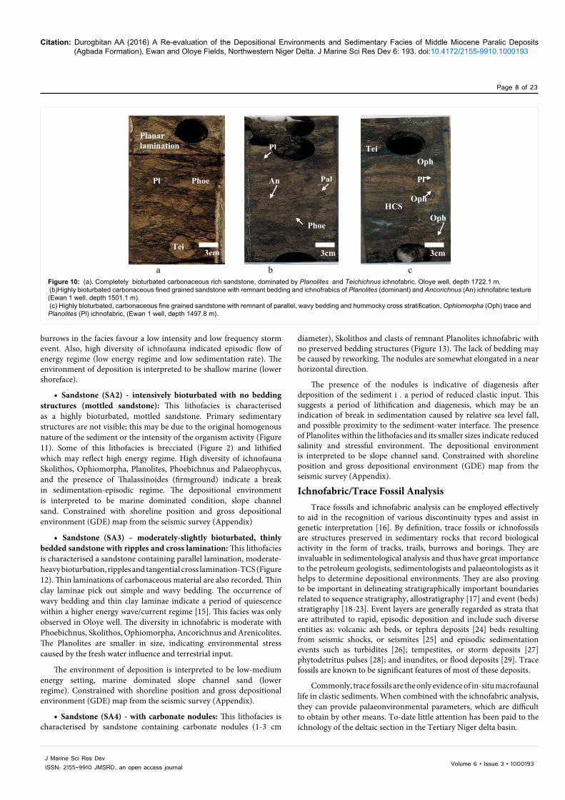
• Sandstone (SA1) - intensively bioturbated sandstone with remnant bedding and ichnofabric textures: This lithofacies occurred in both the Ewan 1 and Oloye 3 wells and is characterised as brownish sandstone, with remnant bedding structures (cross stratification-possibly hummocky cross stratification (HCS?) and planar lamination) (Figure 5), and a composite ichnofabric. The ichno-diversity is high with a Teichichnus, Ancorichnus, Palaeophycus, Planolites, Skolithos, Ophiomorpha and Phoebichnus ichnofauna with Planolites, Phoebichnus and Teichichnus as dominant ichnofabrics (Figure 10). The result is that the sediment is completely bioturbated and most of the original sedimentary structures are not visible. The style of burrows varies from horizontal, vertical and inclined to homogenised structures. The presence of cross lamination may indicate storm deposition [13,14]. The intensity of fair-weather burrowing is variable, depending upon the degree of storm dominance. High intensity and diversity of
a b
Phoe
Pl Phoe
3cm
Phoe
Pl
3cm
Phoe
Pl Phoe
3cm
Phoe
Pl
Phoe
Pl Phoe
3cm
Phoe
Pl
3cm
Figure 8: Laminated sandy mudstone showing intercalation of sandstone and indurated mudstone layers 1498.7 m (a) and 1498.4 m (b) within Ewan well. Planolites, Palaeophycus, Ophiomorpha and Phoebichnus ichnofabric were also observed.
Figure 8: Laminated sandy mudstone showing intercalation of sandstone and indurated mudstone layers 1498.7 m (a) and 1498.4 m (b) within Ewan well. Planolites, Palaeophycus, Ophiomorpha and Phoebichnus ichnofabric were also observed.
Laminated mudstone
3cm3cm
ba
Pl
Phoe
Pal
Sandstone with ripples lamination
An
PhoeLaminated mudstone
3cm3cm
ba
Pl
Phoe
Pal
Sandstone with ripples lamination
An
Phoe
Figure 9: Bioturbated laminated muddy sandstone showing intercalation of sand layer and indurated muddy layers. a and b occurred at depth 1502.2 m and 1502.4 m respectively within Ewan 1 well. Planolites, Palaeophycus, Ancorichnus and Phoebichnus ichnofabric were also observed.
Figure 9: Bioturbated laminated muddy sandstone showing intercalation of sand layer and indurated muddy layers. a and b occurred at depth 1502.2 m and 1502.4 m respectively within Ewan 1 well. Planolites, Palaeophycus, Ancorichnus and Phoebichnus ichnofabric were also observed.
Citation: Durogbitan AA (2016) A Re-evaluation of the Depositional Environments and Sedimentary Facies of Middle Miocene Paralic Deposits (Agbada Formation), Ewan and Oloye Fields, Northwestern Niger Delta. J Marine Sci Res Dev 6: 193. doi:10.4172/2155-9910.1000193
Page 8 of 23
Volume 6 • Issue 3 • 1000193J Marine Sci Res DevISSN: 2155-9910 JMSRD, an open access journal
burrows in the facies favour a low intensity and low frequency storm event. Also, high diversity of ichnofauna indicated episodic flow of energy regime (low energy regime and low sedimentation rate). The environment of deposition is interpreted to be shallow marine (lower shoreface).
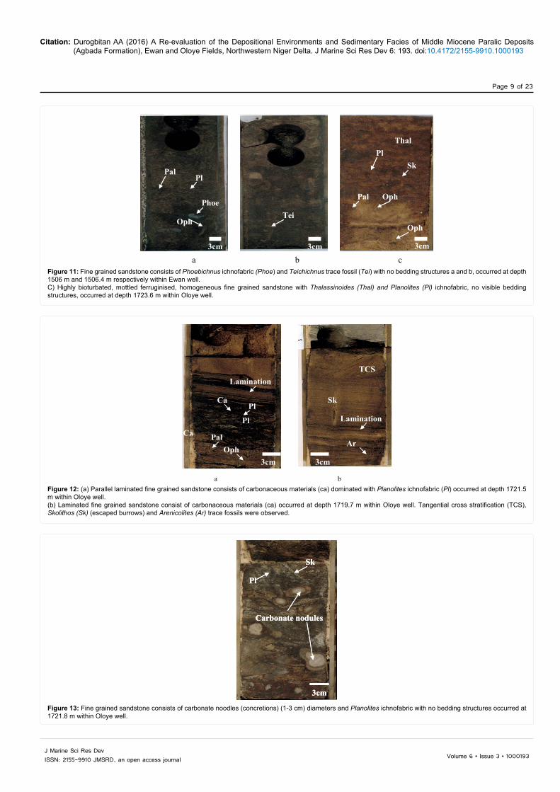
• Sandstone (SA2) - intensively bioturbated with no bedding structures (mottled sandstone): This lithofacies is characterised as a highly bioturbated, mottled sandstone. Primary sedimentary structures are not visible; this may be due to the original homogenous nature of the sediment or the intensity of the organism activity (Figure 11). Some of this lithofacies is brecciated (Figure 2) and lithified which may reflect high energy regime. High diversity of ichnofauna Skolithos, Ophiomorpha, Planolites, Phoebichnus and Palaeophycus, and the presence of Thalassinoides (firmground) indicate a break in sedimentation-episodic regime. The depositional environment is interpreted to be marine dominated condition, slope channel sand. Constrained with shoreline position and gross depositional environment (GDE) map from the seismic survey (Appendix)
• Sandstone (SA3) – moderately-slightly bioturbated, thinly bedded sandstone with ripples and cross lamination: This lithofacies is characterised a sandstone containing parallel lamination, moderate-heavy bioturbation, ripples and tangential cross lamination-TCS (Figure 12). Thin laminations of carbonaceous material are also recorded. Thin clay laminae pick out simple and wavy bedding. The occurrence of wavy bedding and thin clay laminae indicate a period of quiescence within a higher energy wave/current regime [15]. This facies was only observed in Oloye well. The diversity in ichnofabric is moderate with Phoebichnus, Skolithos, Ophiomorpha, Ancorichnus and Arenicolites. The Planolites are smaller in size, indicating environmental stress caused by the fresh water influence and terrestrial input.
The environment of deposition is interpreted to be low-medium energy setting, marine dominated slope channel sand (lower regime). Constrained with shoreline position and gross depositional environment (GDE) map from the seismic survey (Appendix).
• Sandstone (SA4) - with carbonate nodules: This lithofacies is characterised by sandstone containing carbonate nodules (1-3 cm
Thal
diameter), Skolithos and clasts of remnant Planolites ichnofabric with no preserved bedding structures (Figure 13). The lack of bedding may be caused by reworking. The nodules are somewhat elongated in a near horizontal direction.
The presence of the nodules is indicative of diagenesis after deposition of the sediment i . a period of reduced clastic input. This suggests a period of lithification and diagenesis, which may be an indication of break in sedimentation caused by relative sea level fall, and possible proximity to the sediment-water interface. The presence of Planolites within the lithofacies and its smaller sizes indicate reduced salinity and stressful environment. The depositional environment is interpreted to be slope channel sand. Constrained with shoreline position and gross depositional environment (GDE) map from the seismic survey (Appendix).
Ichnofabric/Trace Fossil AnalysisTrace fossils and ichnofabric analysis can be employed effectively
to aid in the recognition of various discontinuity types and assist in genetic interpretation [16]. By definition, trace fossils or ichnofossils are structures preserved in sedimentary rocks that record biological activity in the form of tracks, trails, burrows and borings. They are invaluable in sedimentological analysis and thus have great importance to the petroleum geologists, sedimentologists and palaeontologists as it helps to determine depositional environments. They are also proving to be important in delineating stratigraphically important boundaries related to sequence stratigraphy, allostratigraphy [17] and event (beds) stratigraphy [18-23]. Event layers are generally regarded as strata that are attributed to rapid, episodic deposition and include such diverse entities as: volcanic ash beds, or tephra deposits [24] beds resulting from seismic shocks, or seismites [25] and episodic sedimentation events such as turbidites [26]; tempestites, or storm deposits [27] phytodetritus pulses [28]; and inundites, or flood deposits [29]. Trace fossils are known to be significant features of most of these deposits.
Commonly, trace fossils are the only evidence of in-situ macrofaunal life in clastic sediments. When combined with the ichnofabric analysis, they can provide palaeonvironmental parameters, which are difficult to obtain by other means. To-date little attention has been paid to the ichnology of the deltaic section in the Tertiary Niger delta basin.
a b c
Tei
Pl
HCS
An Phoe
Oph
Pl
Tei
3cm 3cm 3cm
Planar lamination
Phoe
Pal
Pl
Oph
Oph
Figure 10: (a). Completely bioturbated carbonaceous rich sandstone, dominated by Planolites and Teichichnus ichnofabric. Oloye well, depth 1722.1 m. (b)Highly bioturbated carbonaceous fined grained sandstone with remnant bedding and ichnofrabics of Planolites (dominant) and Ancorichnus (An) ichnofabric texture (Ewan 1 well, depth 1501.1 m). (c) Highly bioturbated, carbonaceous fine grained sandstone with remnant of parallel, wavy bedding and hummocky cross stratification, Ophiomorpha (Oph) trace and Planolites (Pl) ichnofabric, (Ewan 1 well, depth 1497.8 m).
Figure 10: (a). Completely bioturbated carbonaceous rich sandstone, dominated by Planolites and Teichichnus ichnofabric. Oloye well, depth 1722.1 m. (b)Highly bioturbated carbonaceous fined grained sandstone with remnant bedding and ichnofrabics of Planolites (dominant) and Ancorichnus (An) ichnofabric texture (Ewan 1 well, depth 1501.1 m). (c) Highly bioturbated, carbonaceous fine grained sandstone with remnant of parallel, wavy bedding and hummocky cross stratification, Ophiomorpha (Oph) trace and Planolites (Pl) ichnofabric, (Ewan 1 well, depth 1497.8 m).
Citation: Durogbitan AA (2016) A Re-evaluation of the Depositional Environments and Sedimentary Facies of Middle Miocene Paralic Deposits (Agbada Formation), Ewan and Oloye Fields, Northwestern Niger Delta. J Marine Sci Res Dev 6: 193. doi:10.4172/2155-9910.1000193
Page 9 of 23
Volume 6 • Issue 3 • 1000193J Marine Sci Res DevISSN: 2155-9910 JMSRD, an open access journal
a b c
Phoe
Tei
Phoee
Thal
Tei
Sk
Thal
Pal
Oph
Pl
Pl
Phoe
Oph
Pal
3cm 3cm
Oph
3cm
Phoe
Tei
Phoee
Thal
Tei
Sk
Thal
Pal
Oph
Pl
Pl
Phoe
Oph
Pal
3cm 3cm
OphPhoe
Tei
Phoee
Thal
Tei
Sk
Thal
Pal
Oph
Pl
Pl
Phoe
Oph
Pal
3cm 3cm
Oph
3cm
Figure 11: Fine grained sandstone consists of Phoebichnus ichnofabric (Phoe) and Teichichnus trace fossil (Tei) with no bedding structures a and b, occurred at depth 1506 m and 1506.4 m respectively within Ewan well. C) Highly bioturbated, mottled ferruginised, homogeneous fine grained sandstone with Thalassinoides (Thal) and Planolites (Pl) ichnofabric, no visible bedding structures, occurred at depth 1723.6 m within Oloye well.
Figure 11: Fine grained sandstone consists of Phoebichnus ichnofabric (Phoe) and Teichichnus trace fossil (Tei) with no bedding structures a and b, occurred at depth 1506 m and 1506.4 m respectively within Ewan well. C) Highly bioturbated, mottled ferruginised, homogeneous fine grained sandstone with Thalassinoides (Thal) and Planolites (Pl) ichnofabric, no visible bedding structures, occurred at depth 1723.6 m within Oloye well.
a b
TCS
Pl
Ar
3cm
Sk
Lamination
Pal
Pl Lamination
Oph3cm
Ca
TCS
Pl Ca
Ar
3cm
Sk
Lamination
Pal
Pl Lamination
Oph3cm
Ca
Figure 12: (a) Parallel laminated fine grained sandstone consists of carbonaceous materials (ca) dominated with Planolites ichnofabric (Pl) occurred at depth 1721.5 m within Oloye well. (b) Laminated fine grained sandstone consist of carbonaceous materials (ca) occurred at depth 1719.7 m within Oloye well. Tangential cross stratification (TCS), Skolithos (Sk) (escaped burrows) and Arenicolites (Ar) trace fossils were observed.
Figure 12: (a) Parallel laminated fine grained sandstone consists of carbonaceous materials (ca) dominated with Planolites ichnofabric (Pl) occurred at depth 1721.5 m within Oloye well. (b) Laminated fine grained sandstone consist of carbonaceous materials (ca) occurred at depth 1719.7 m within Oloye well. Tangential cross stratification (TCS), Skolithos (Sk) (escaped burrows) and Arenicolites (Ar) trace fossils were observed.
Carbonate nodules
Pl
3cm
Sk
Carbonate nodules
Pl
3cm
Sk
Carbonate nodules
Pl
3cm
Sk
Figure 13: Fine grained sandstone consists of carbonate noodles (concretions) (1-3 cm) diameters and Planolites ichnofabric with no bedding structures occurred at 1721.8 m within Oloye well.
Figure 13: Fine grained sandstone consists of carbonate noodles (concretions) (1-3 cm) diameters and Planolites ichnofabric with no bedding structures occurred at 1721.8 m within Oloye well.
Citation: Durogbitan AA (2016) A Re-evaluation of the Depositional Environments and Sedimentary Facies of Middle Miocene Paralic Deposits (Agbada Formation), Ewan and Oloye Fields, Northwestern Niger Delta. J Marine Sci Res Dev 6: 193. doi:10.4172/2155-9910.1000193
Page 10 of 23
Volume 6 • Issue 3 • 1000193J Marine Sci Res DevISSN: 2155-9910 JMSRD, an open access journal
A re-evaluation of depositional environments of the Agbada Formation in the northwestern Niger delta (Ewan and Oloye fields) [30] was carried out, incorporating an ichnological description based on analysis of core photos. This has resulted in a revision of the facies scheme originally outlined by [1-5,11]. A summary of the facies scheme within the study area is given in Table 1.
The cored intervals studied within the Ewan 1 and Oloye 3 wells contain diverse assemblages of trace fossils that show a palaeoenvironmental control on their distribution. This has allowed the facies analysis to be refined, when combined with wireline logs and sedimentological interpretation. The diverse assemblages of trace fossils documented from the core studies are listed below. They are: - Planolites, Palaeophycus, Phoebichnus, Teichichnus, Thalassinoides, Skolithos, Arenicolites and Ophiomorpha.
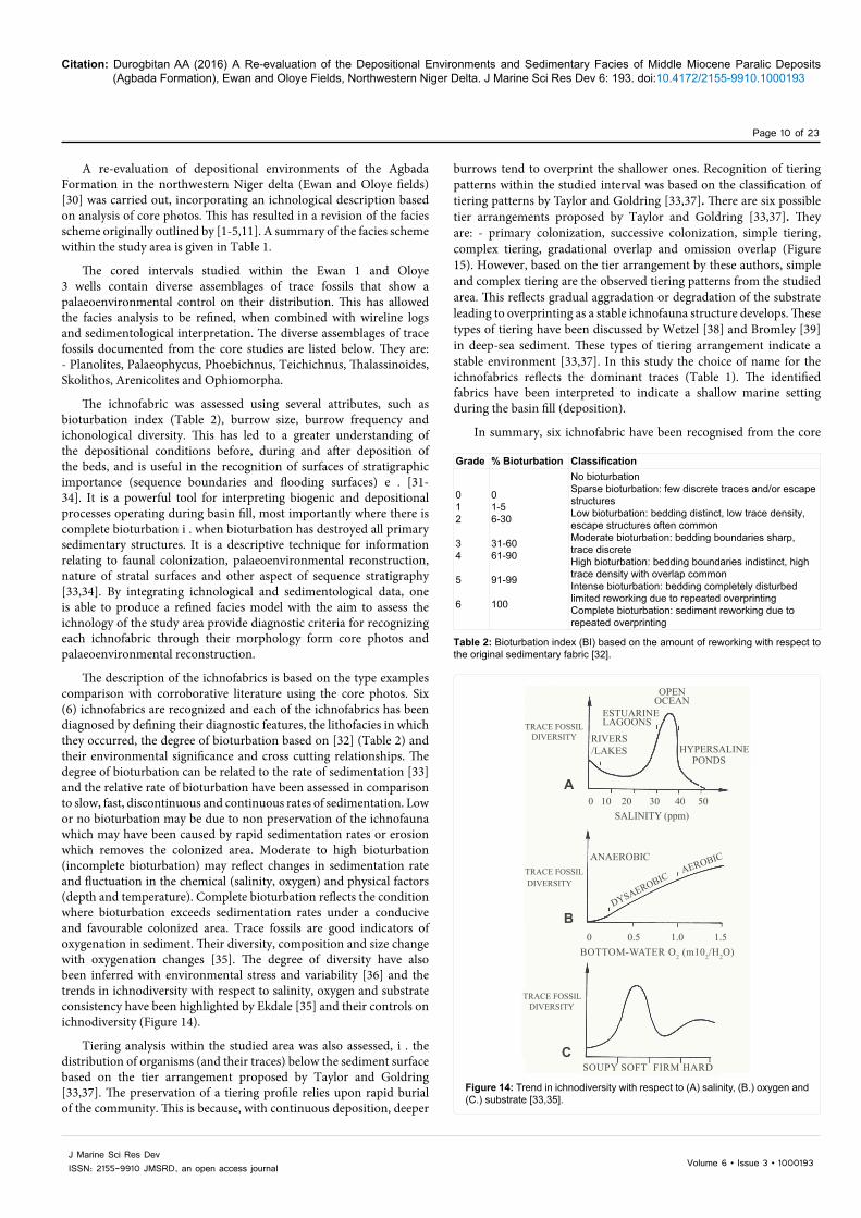
The ichnofabric was assessed using several attributes, such as bioturbation index (Table 2), burrow size, burrow frequency and ichonological diversity. This has led to a greater understanding of the depositional conditions before, during and after deposition of the beds, and is useful in the recognition of surfaces of stratigraphic importance (sequence boundaries and flooding surfaces) e . [31-34]. It is a powerful tool for interpreting biogenic and depositional processes operating during basin fill, most importantly where there is complete bioturbation i . when bioturbation has destroyed all primary sedimentary structures. It is a descriptive technique for information relating to faunal colonization, palaeoenvironmental reconstruction, nature of stratal surfaces and other aspect of sequence stratigraphy [33,34]. By integrating ichnological and sedimentological data, one is able to produce a refined facies model with the aim to assess the ichnology of the study area provide diagnostic criteria for recognizing each ichnofabric through their morphology form core photos and palaeoenvironmental reconstruction.
The description of the ichnofabrics is based on the type examples comparison with corroborative literature using the core photos. Six (6) ichnofabrics are recognized and each of the ichnofabrics has been diagnosed by defining their diagnostic features, the lithofacies in which they occurred, the degree of bioturbation based on [32] (Table 2) and their environmental significance and cross cutting relationships. The degree of bioturbation can be related to the rate of sedimentation [33] and the relative rate of bioturbation have been assessed in comparison to slow, fast, discontinuous and continuous rates of sedimentation. Low or no bioturbation may be due to non preservation of the ichnofauna which may have been caused by rapid sedimentation rates or erosion which removes the colonized area. Moderate to high bioturbation (incomplete bioturbation) may reflect changes in sedimentation rate and fluctuation in the chemical (salinity, oxygen) and physical factors (depth and temperature). Complete bioturbation reflects the condition where bioturbation exceeds sedimentation rates under a conducive and favourable colonized area. Trace fossils are good indicators of oxygenation in sediment. Their diversity, composition and size change with oxygenation changes [35]. The degree of diversity have also been inferred with environmental stress and variability [36] and the trends in ichnodiversity with respect to salinity, oxygen and substrate consistency have been highlighted by Ekdale [35] and their controls on ichnodiversity (Figure 14).
Tiering analysis within the studied area was also assessed, i . the distribution of organisms (and their traces) below the sediment surface based on the tier arrangement proposed by Taylor and Goldring [33,37]. The preservation of a tiering profile relies upon rapid burial of the community. This is because, with continuous deposition, deeper
burrows tend to overprint the shallower ones. Recognition of tiering patterns within the studied interval was based on the classification of tiering patterns by Taylor and Goldring [33,37]. There are six possible tier arrangements proposed by Taylor and Goldring [33,37]. They are: - primary colonization, successive colonization, simple tiering, complex tiering, gradational overlap and omission overlap (Figure 15). However, based on the tier arrangement by these authors, simple and complex tiering are the observed tiering patterns from the studied area. This reflects gradual aggradation or degradation of the substrate leading to overprinting as a stable ichnofauna structure develops. These types of tiering have been discussed by Wetzel [38] and Bromley [39] in deep-sea sediment. These types of tiering arrangement indicate a stable environment [33,37]. In this study the choice of name for the ichnofabrics reflects the dominant traces (Table 1). The identified fabrics have been interpreted to indicate a shallow marine setting during the basin fill (deposition).
In summary, six ichnofabric have been recognised from the core
Grade % Bioturbation Classification
012
34
5
6
01-56-30
31-6061-90
91-99
100
No bioturbationSparse bioturbation: few discrete traces and/or escape structuresLow bioturbation: bedding distinct, low trace density, escape structures often commonModerate bioturbation: bedding boundaries sharp, trace discreteHigh bioturbation: bedding boundaries indistinct, high trace density with overlap commonIntense bioturbation: bedding completely disturbed limited reworking due to repeated overprintingComplete bioturbation: sediment reworking due to repeated overprinting
Table 2: Bioturbation index (BI) based on the amount of reworking with respect to the original sedimentary fabric [32].
Figure 14: Trend in ichnodiversity with respect to (A) salinity, (B.) oxygen and (C.) substrate [33,35].
OPENOCEAN
ESTUARINELAGOONSTRACE FOSSIL
DIVERSITYHYPERSALINE
RIVERS/LAKES
0 10 20 30 40 50
0 0.5 1.0 1.5
SALINITY (ppm)
ANAEROBIC
BOTTOM-WATER O2 (m102/H2O)
SOUPY SOFT FIRM HARD
TRACE FOSSIL
TRACE FOSSIL
DYSAEROBICAEROBIC
DIVERSITY
DIVERSITY
A
B
C
PONDS
Figure 14: Trend in ichnodiversity with respect to (A) salinity, (B.) oxygen and (C.) substrate [33,35].

Citation: Durogbitan AA (2016) A Re-evaluation of the Depositional Environments and Sedimentary Facies of Middle Miocene Paralic Deposits (Agbada Formation), Ewan and Oloye Fields, Northwestern Niger Delta. J Marine Sci Res Dev 6: 193. doi:10.4172/2155-9910.1000193
Page 11 of 23
Volume 6 • Issue 3 • 1000193J Marine Sci Res DevISSN: 2155-9910 JMSRD, an open access journal
intervals and are described below.
Planolites/Teichichnus ichnofabrics
Description: This composite ichnofabric is found in association with heterolithic facies (HE2) within slope channel sand. The beds are carbonaceous rich muddy sandstone with diverse assemblages of horizontal burrows showing disruption due to faunal activities, No distinct sedimentary structures are observed due to the intense bioturbation of trace fossils. The associated ichnofauna comprises an opportunistic colonization of Palaeophycus (Pal), Ophiomorpha (Oph), Skolithos (Sk) and Phoebichnus (Phoe) (Figure 16).
Ichnology: Bioturbation is complete (BI=6) with burrows commonly overlapping. The density of burrowing is high with five types of trace fossils recorded. The Planolites burrows show elongate forms (0.3-0.5 mm in diameter) and an irregular, retrusive Teichichnus (Tei) ichnofabric (1-3 cm). The associated trace fossils include Ophiomorpha which show thick pellet walled horizontal shaft (0.05-0.1 cm), Palaeophycus (Pal) (lined burrows) which are horizontal-oblique, elongated-ovate small burrows and Phoebichnus (Phoe) which is an elongated burrow. This ichnofabric is characterized by complex tiering.
Environmental interpretation: The high diversity suggests that this ichnofacies is more marine than facies MS1-3, which reflects the
A. PRIMARY COLONISATIONFirst colonisation event typically by an opportunistic ichnofaunae.g. Ophiomorpha.
B. SUCCESSIVE COLONISATIONAggradation and low diversity ichnofauna leads to burrow overlape.g. Ophiomorpha.
C. SIMPLE TIERINGFirst colonisation event by a tiered community e.g. Planolites (1),Gyrochorte (2), Asterosoma (3) andRosselia (4).
D. COMPLEX TIERINGAggradation and degradation of the substrate leads to overprinting by the infauna community (as C).
E. GRADATIONAL OVERLAPGradual change in the environment leads to a change in the ichnofauna so that the first community of Planolities (1) and Skolithos (2) is overlapped by the second community of Diplocraterion (3).
F. OMISSION OVERLAPSharp change in facies/lithology so that two communities overlap e.g. soft ground community of Planolities (1) and Teichichnus (2) has been exhumed, dewatered and now is a firm-ground burrowed by Thalassinoides (3).
Figure 15: Diagrammatic illustration of the six possible styles of tiering (primary colonization, successive colonization, simple tiering, complex tiering, gradational overlap and omission overlap) as proposed by [37].
Figure 15: Diagrammatic illustration of the six possible styles of tiering (primary colonization, successive colonization, simple tiering, complex tiering, gradational overlap and omission overlap) as proposed by Goldring [37].
Tei
Pl
3cm
Phoe
Pal
Oph
3cm
Phoe
Tei
Pl
Pl Pal
Pl Pl
Oph
Tei
Pl
3cm
Phoe
Pal
Oph
3cm
Phoe
Tei
Pl
Pl Pal
Pl Pl
Oph
Figure 16: Completely bioturbated, carbonaceous muddy sandstone. This has been burrowed by 3cm irregular, retrusive Teichichnus (Tei), and 0.05 - 0.1cm elongated burrows of Planolites (Pl).
Figure 16: Completely bioturbated, carbonaceous muddy sandstone. This has been burrowed by 3cm irregular, retrusive Teichichnus (Tei), and 0.05 - 0.1cm elongated burrows of Planolites (Pl).

Citation: Durogbitan AA (2016) A Re-evaluation of the Depositional Environments and Sedimentary Facies of Middle Miocene Paralic Deposits (Agbada Formation), Ewan and Oloye Fields, Northwestern Niger Delta. J Marine Sci Res Dev 6: 193. doi:10.4172/2155-9910.1000193
Page 12 of 23
Volume 6 • Issue 3 • 1000193J Marine Sci Res DevISSN: 2155-9910 JMSRD, an open access journal
conducive environmental conditions, with the traces demonstrating a deposit-feeding mode of life. The presence of Skolithos (Sk) may indicate water movement/agitation and high sediment supply. The depositional environment is interpreted to be marine dominated slope channel fan based on the observed ichnofauna, constrained with shoreline position from the seismic survey (Appendix).
Planolites/Phoebichnus ichnofabric
Description: This ichnofabric contains Planolites (Pl)-Phoebichnus (Phoe) occurring in a heterolithic (HE4) and thinly bedded cross laminated sandstone facies (SA3) (Figure 17). The sediments are typically slightly–moderately bioturbated with a diverse ichnofauna consisting of fully a marine ichnotaxa of Skolithos (Sk), Ophiomorpha (Oph), Arenicolites (Ar) and Palaeophycus (Pal). Phoebichnus consist of elongated burrows (0.5-1.5 mm) while Planolites is represented by small unlined contrasting fill burrows (0.3-0.5 mm in diameter) (Figure 6).
Ichnology: This represents incomplete bioturbation (BI=3-5). The style of burrows is horizontal to elongate showing a high diversity, with four trace fossils recorded. The burrows of Planolites tend to produce horizontal to elongated burrows (0.05-0.1 cm in diameter) and elongated to cylindrical Phoebichnus ichnofabric (1-2 cm).
Environmental interpretation: Based on the above description, the depositional environment in which the ichnofabric is developed is inferred to be a marine setting with moderate to low rate of sedimentation in a lower shoreface below fair-weather wave base depositional environment.
Planolites ichnofabric
Description: The Planolites ichnofabric is composed of exclusively millimetres scale sand/mud filled Planolites, and is common in the sandstone facies of Ewan and Oloye wells. Bioturbation is characterised by incomplete bioturbation, burrowed by Planolites characterised as a small burrow with contrasting fill. Some Skolithos burrows are also observed. The level of bioturbation varies from low to moderate (BI=2-4) with few burrows overlapping. The burrow density can be interpreted as moderate consisting mostly of a mono-specific fauna, Planolites. The Planolites burrows are small size with a convoluted
form. They are horizontal to oblique, simple flattened cylinders, which are 0.03-0.1 cm diameter. Carbonaceous materials are found as a thin bed within the lamination (Figure 18).
Ichnology: Diagnostically, Planolites here differs from Ancorichnus (An) in terms of the fill in the core of the burrows and from Palaeophycus in terms of morphology and wall structure. Palaeophycus tends to be infilled with sediment that is the same as the host matrix, whereas the sediment filling unlined Planolites tends to differ in composition [12]. The Planolites burrow fill differs from the host material indicating an active back filling of sediment by expulsion by a mobile deposit feeder that occurs in many environments and is probably produced by a number of different organisms [12,40].
Environmental interpretation: Based on the low diversity of trace fossils, the presences of carbonaceous rich material with cross and parallel lamination, the environment is interpreted to be medium-high energy settings, lower shoreface and slope channel fan complexes. It is noted that this ichnofabric is different from Planolites-Teichichnus ichnofabric in term of size. Planolites observed in this lithofacies are smaller and the small size of Planolites could be due to environmental stress. Low diversity of the ichnofauna may be due to influx of fresh water into the environment. The presence of Planolites within the diagenetic sandstone nodules suggests reduced salinity, and stressful depositional environment.
Planolites/Thalassinoides ichnofabric
Description: This composite ichnofabric is found within the intensive bioturbated sandstone facies with no remnant bedding structures observed (SA2). The sediment was colonized by Planolites and overprinted by Thalassinoides (Thal). They are characterized as completely bioturbated, reddish brown, mottled, fine grained sandstone with patches of carbonaceous material. It is difficult to discern sedimentary structures as the sandstone is homogeneous as a result of the bioturbation and ferruginisation. The trace fossil fabric is composed mainly of Planolites, comprising oval-elongated sand filled burrows with a mottled firm ground Thalassinoides ichnofabirc. In this core, the fabric of Planolites and Thalassinoides consists of elongated burrows ranging 0.05-1 cm diameter (Figure 19).
Ichnology: The bioturbation is complete (BI=6). The burrow
PhoePl
3cm
Pal
Phoe Oph
Pal Phoe
Pl
Pal
Pal
Phoe
Oph
3cm
PhoePl
3cm
Pal
Phoe Oph
Pal
PhoePl
3cm
Pal
Phoe Oph
Pal Phoe
Pl
Pal
Pal
Phoe
Oph
3cmFigure 17: Incomplete bioturbated, carbonaceous mudstone dominated heterolithic. Burrowed by 1-2 cm diameter cylindrical burrows of Phoebichnus (Phoe) and 0.05-0.1 cm sand filled burrow of Planolites (Pl).
Figure 17: Incomplete bioturbated, carbonaceous mudstone dominated heterolithic. Burrowed by 1-2 cm diameter cylindrical burrows of Phoebichnus (Phoe) and 0.05-0.1 cm sand filled burrow of Planolites (Pl).

Citation: Durogbitan AA (2016) A Re-evaluation of the Depositional Environments and Sedimentary Facies of Middle Miocene Paralic Deposits (Agbada Formation), Ewan and Oloye Fields, Northwestern Niger Delta. J Marine Sci Res Dev 6: 193. doi:10.4172/2155-9910.1000193
Page 13 of 23
Volume 6 • Issue 3 • 1000193J Marine Sci Res DevISSN: 2155-9910 JMSRD, an open access journal
density and diversity is high, and consists of Planolites, Skolithos, Ophiomorpha, Phoebichnus, Palaeophycus and Thalassinoides. The diagnostic feature of Thalassinoides is the burrows have no fill structure which allows possible distinction between large Planolites that are an unlined actively filled burrow system [12].
Environmental interpretation: The presence of the Thalassinoides fabric results from processes operating in a marine environment and it occurs in a great variety of marine environments. The Thalassinoides ichnofabric has been recorded from fresh water fluvial conditions in fully marine shorefaces [41] in the upper Jurassic Fulmar Formation continental shelf [33], in the offshore transition zone below storm wave base level of the Nukul Formation, Suez Rift, Egypt [42] and is considered to be environmentally non diagnostic [43].
Based on this core, the associated lithofacies and context, the Planolites/Thalassinoides ichnofabric environment is interpreted to be marine dominated slope channel sand, constrained with shoreline position from the seismic survey (Appendix). This ichnofabric indicates increasing substrate cohesion from softground condition into firmground condition. High diversity of trace fossils within the facies
and presence of Thalassinoides indicates a break in sedimentation that has led to early compaction (firmground), developed from initial softground. This suggests that the energy regime is episodic.
Teichichnus/Phoebichnus/Planolites ichnofabric
Description: This ichnofabric is found in association with highly bioturbated sandstones containing remnant bedding structures (SA1). The level of bioturbation is high and the sediments are characterised as being incomplete to complete bioturbated, greyish, fine-grained, carbonaceous muddy sandstone. It is dominated by an irregular, retrusive Teichichnus ichnofabric, comprising cylindrical burrows of Phoebichnus and elongated burrows of Planolites. They are associated with variety of other trace fossils which include, Palaeophycus, Ancorichnus, Ophiomorpha, Skolithos and Planolites. It is difficult to recognize any original sedimentary structures either due to the high level of bioturbation or the original homogeneous nature of the sediment (Figure 20).
Ichnology: The level of the bioturbation can be classified as complete bioturbation with burrow overlap (BI=6). The burrow density
Pl
3cm
Pl
Pal
Oph
Pl
3cm
Pal
Oph Oph Pal
Pl
Pl
Pl3cm
Pl
3cm
Pl
Pal
Oph
Pl
3cm
Pal
Oph Oph Pal
Pl
Pl
Pl3cm
Pl
3cm
Pl
Pal
Oph
Pl
3cm
Pal
Oph
Pl
3cm
Pl
Pal
Oph
Pl
3cm
Pl
Pal
Oph
Pl
3cm
Pal
Oph
Pl
3cm
Pal
Oph Oph Pal
Pl
Pl
Pl3cm
Figure 18: Incompletely bioturbated, carbona-ceous-rich, fine grained sandstone which exhibits mm- scale planar laminations. This has been burrowed by 0.03 - 0.1 cm diameter, sand filled burrows of Planolites (Pl). This is an example of primary colonisation.
Figure 18: Incompletely bioturbated, carbonaceous-rich, fine grained sandstone which exhibits mm- scale planar laminations. This has been burrowed by 0.03 - 0.1 cm diameter, sand filled burrows of Planolites (Pl). This is an example of primary colonisation.
Thal
Pl
Sk
Oph
Oph
Pal
Oph
Pal
3cm
Oph
SkPal
Pl
Thal
Oph
3cm
Thal
Pl
Sk
Oph
Oph
Pal
Oph
Pal
3cm
Oph
SkPal
Pl
Thal
Oph
3cm
Thal
Pl
Sk
Oph
Oph
Pal
Oph
Pal
3cm
Oph
SkPal
Pl
Thal
Oph
3cmFigure 19: Completely bioturbated, mottled, ferruginised sandstones. Burrowed by 0.05 – 0.1cm sand filled Planolites, 0.1-0.2cm Thalassinoides and vertical burrow Skolithos. The presence of Thalassinoides indicate break in sedimentation and early cementation (firm ground). This suggests that the energy regime is episodic.
Figure 19: Completely bioturbated, mottled, ferruginised sandstones. Burrowed by 0.05 – 0.1cm sand filled Planolites, 0.1-0.2cm Thalassinoides and vertical burrow Skolithos. The presence of Thalassinoides indicate break in sedimentation and early cementation (firm ground). This suggests that the energy regime is episodic.

Citation: Durogbitan AA (2016) A Re-evaluation of the Depositional Environments and Sedimentary Facies of Middle Miocene Paralic Deposits (Agbada Formation), Ewan and Oloye Fields, Northwestern Niger Delta. J Marine Sci Res Dev 6: 193. doi:10.4172/2155-9910.1000193
Page 14 of 23
Volume 6 • Issue 3 • 1000193J Marine Sci Res DevISSN: 2155-9910 JMSRD, an open access journal
is high with a high level of diversity of the ichnofauna. The style of burrows varies from horizontal, vertical and inclined to homogenised structures.
Environmental interpretation: This type of ichnofabric has been recorded within the sand siltstone event beds from the middle Jurassic Not Formation, Norwegian continental shelf [33]. But in this work, these ichnofabrics are recorded in the lower shoreface. The intensity of bioturbation and the diverse nature of the assemblages suggests episodic flow of energy regime and sediment reworking.
Palaeophycus-planolites ichnofabric
Description: Completely bioturbated, disrupted, greyish sandy mudstone with high density of Palaeophycus, Phoebichnus and Planolites showing low ichnofauna diversity. The sandy mudstone lacks any discernable sedimentary structures due to the intensity of bioturbation. Morphologically, Palaeophycus has been differentiated from Planolites by the burrow infill because of their similarity in burrows style. The Palaeophycus infill tends to be the same material as the host matrix, and is interpreted as an open tube produced by carnivorous of omnivorous invertebrates, mostly polychaetes, whereas
that of sediments filling unlined Planolites tends to differ [12]. Within these beds, the Palaeophycus burrows are oriented horizontal-oblique, elongated-ovate small size burrows with fill similar to the host (Figure 21).
Ichnology: This facies is classified as complete bioturbated (BI=6). Burrows intensity is high but diversity is low, being restricted to Palaeophycus, Phoebichnus and Planolites.
Environmental interpretation: Palaeophycus ichnofabric has been recorded in the middle Jurassic Not Formation, Norwegian continental shelf, Palaeophycus trace fossil has also been recorded in the offshore transition zone below storm wave base level of Nukul Formation, Suez Rift, Egypt [42]. In this study area, Palaeophycus and Planolites have been encountered in the lower shoreface environment.
Summary Interpretation of Ewan 1 Well CoresThe thickness of the cored interval is 15 m. The sediments are
characterized as moderately to intensively bioturbated, fine grained muddy sandstones, sandy mudstones and mudstone that contain a pervasive and irregular ichnofabric composed of burrows of Skolithos, Ophiomorpha, Arenicolites, Planolites, Palaeophycus, Ancorichnus,
3cm
Tei
Phoe
3cma
An
Tei
Pal
Pl
Pl
Tei
Phoe
3cmb
Pal Pl
Oph
Tei
Phoe
3cma
An
Tei
Pal
Pl
Pl
An
OphPal
3cm
Tei
Phoe
3cma
An
Tei
Pal
Pl
Pl
Tei
Phoe
3cmb
Pal Pl
Oph
Tei
Phoe
3cmb
Pal Pl
Oph
Tei
Phoe
3cma
An
Tei
Pal
Pl
Pl
An
OphPal
Figure 20: (a) Completely bioturbated, carbonaceous muddy sandstone, (b) incompletely bioturbated fine grained sandstone. This has been burrowed by 0.5-2 cm irregular, retrusive Teichichnus, 0.5-2 cm cylindrical burrows of Phoebichnus and 0.05-0.1 cm elongated burrows of Planolites.
Figure 20: (a) Completely bioturbated, carbonaceous muddy sandstone, (b) incompletely bioturbated fine grained sandstone. This has been burrowed by 0.5-2 cm irregular, retrusive Teichichnus, 0.5-2 cm cylindrical burrows of Phoebichnus and 0.05-0.1 cm elongated burrows of Planolites.
Pal
Pl
Phoe
3cm
Phoe
Pl
Pal
3cm
Pal
Pl
Phoe
3cm
Phoe
Pl
Pal
3cmFigure 21: Completely bioturbated, structureless and highly disrupted sandy mudstones. This has been burrowed by small ovate–elongated 0.3-0.5 mm diameter sand filled burrows of Planolites and Palaeophycus.
Figure 21: Completely bioturbated, structureless and highly disrupted sandy mudstones. This has been burrowed by small ovate–elongated 0.3-0.5 mm diameter sand filled burrows of Planolites and Palaeophycus.

Citation: Durogbitan AA (2016) A Re-evaluation of the Depositional Environments and Sedimentary Facies of Middle Miocene Paralic Deposits (Agbada Formation), Ewan and Oloye Fields, Northwestern Niger Delta. J Marine Sci Res Dev 6: 193. doi:10.4172/2155-9910.1000193
Page 15 of 23
Volume 6 • Issue 3 • 1000193J Marine Sci Res DevISSN: 2155-9910 JMSRD, an open access journal
Thalassinoides and Teichichnus. Based on the bioturbation index (Table 2), the core interval can be classified as incompletely-completely bioturbated (BI=3-6) [31,32].
This cored interval consists of dominantly sandstone facies (heavily bioturbated sandstone with remnant bedding structures (hummocky cross stratification, wavy bedding and plannar lamination) and ichnofabric texture (SA1), heavily bioturbated homogeneous/mottled sandstone with no remnant bedding (SA2), laminated mudstone dominated heterolithic facies (HE3), laminated sandstone dominated heterolithic (HE4) and laminated indurated mudstone (MS2). The lithofacies within this core are moderately to completely bioturbated. Where they are highly bioturbated the intensity suggest that the sand bodies could be shoreface attached rather than sand shoals i . high energy regime where currents energy are prevailing. This would allow enough time for sediment to be reworked by the ichnofauna as a result of the reduced energy regime.
In this cored interval, the bioturbated sandstones facies (SA1) are interbedded with bioturbated mudstones (MS2) and heterolithic facies (HE4) (Figure 2). The sandstone beds are commonly 1-2.5 m thick with remnant bedding structure overprinted by ichnofabric textures. The cross stratifications, wavy bedding and planar cross beddings observed are of small scale (about 0.6 m bed set thickness). No medium or large scale cross bedding was observed this may be due to the dimension of the core. This may also be a function of grain size control, with cross bedding forming mainly in medium–and coarse grained sand [44].
The cored interval, when located on the wireline log is characterised by being within a relatively continuous coarsening upward facies succession (average 3 m thick), dominated shoreface deposits. There is some degree of facies variability, both sedimentologically and ichnologically. Variability of facies and trace fossils may reflect a combination of water turbidity, water salinity, fluctuating/episodic depositional rate and storm energy condition [45].
Intercalation of sandstone facies with the heterolithic facies reflects deposition during fluctuating energy conditions and their repetitive pattern likely reflects relative changes of sea level controlling the sedimentation. The occurrence of parallel and cross bedding populated by shallow marine ichnofauna also suggests shallow marine sediment deposited within lower shoreface zone under wave and storm influence. The presence of carbonaceous material indicates a terrestrial input. A flooding surface was recognised within this interval on top of facies SA1 at a depth of 1508.4 m (Figure 2), overlain by facies MS2. This surface suggests an increase in water depth (deepening) as a result of relative sea level rise.
Summary Interpretation of Oloye 3 Well CoresThe overall thickness of this cored interval is 11.4 m. The lithofacies
are characterized as slightly to completely bioturbated, fine to muddy sandstone, sandy mudstone and mudstone, with medium to high bioturbation (BI= 2-6). The identified trace fossils and ichnofabrics texture are Planolites, Thalassinoides, Palaeophycus, Phoebichnus, Teichichnus Skolithos, Arenicolites and Ophiomorpha. Inability to decipher the ichnofossils in some of the core interval within this well is due largely to the sediment distortion caused by intensive bioturbation and the homogeneous nature of the substrates. These cores show a general upward-fining motif.
The basal part of the core log (Figure 2), shows a brecciated, intensively bioturbation sandstone with Planolites, Palaeophycus, Phoebichnus, Teichichnus, Thalassinoides and Skolithos trace fossils
dominated by Planolites and Thalassinoides ichnofabrics. High diversity of ichnofauna and the presence of Thalassinoides indicate a break in sedimentation-episodic regime (firmground). There is some iron staining but no distinct bedding structures (SA2). The infill within the Planolites burrows differs from the host materials, which may indicate an active backfilling of the sediment by injection and expulsion by the mobile deposit feeders [12]. The burrows are about 0.2 mm-0.75 mm in diameter. The brecciation indicates early lithification followed by erosion in a high-energy deposition environment. Some of the observed burrows are elongate and aligned parallel to bedding; this may suggest compaction after deposition. The thickness of this unit (SA2) is about 3.3 m.
On top of this is a 0.9 m thick sandstone (SA1) characterised by a composite ichnofabric that formed as a result of the activities of many organisms. The dominant trace fossils observed are Planolites, Teichichnus and Phoebichnus ichnofabric and they range between 0.25 mm-2 cm in diameter with Planolites the smallest diameter. The interval is completely bioturbated (BI=6) and none of the original sedimentary structures are visible. This is overlain by unit (SA4) which is about 0.3 m thick and characterised by containing carbonate nodules. The occurrence of these nodules (0.5 mm-1.5 cm in diameter) indicates a diagenetic overprint which may suggest a period of reduced clastic input and accommodation initiated by sea level fall. The large-scale stratigraphic setting of this unit suggests that nodule formation is linked to clastic sediment bypass. The lack of accommodation caused by the relative fall in sea level in this setting is supported by this presence of carbonate nodules. Based on these observations the top of this facies is interpreted as a candidate sequence boundary (~ depth 1721.5 m) (Figure 2).
Above the sequence boundary about 2 m of sandstone facies (SA1) is characterized by thin beds (0.3 m) of highly bioturbated sandstone with remnant cross-bedding structures and Teichichnus-Phoebichnus-Planolites ichnofabric (0.1 mm-2 cm in diameter). This is followed by about 1.7 m of slightly bioturbated carbonaceous, ferruginised, homogeneous, ripples and cross laminated sandstone facies with Planolites, Palaeophycus-Phoebichnus, ichnofabric (SA3). At the top of this facies, gently dipping trough cross stratifications occurs.
Above SA3 is about 2 m of highly bioturbated muddy sandstone with trace fossils (HE2) of Teichichnus, Palaeophycus, Planolites, Ophiomorpha and Phoebichnus, dominated by Planolites-Teichichnus ichnofabric. The top of the 2 m thick HE2 facies is marked by a flooding surface (transgression) denoted by a bioturbated, laminated indurated mudstone with rare sand streaks (MS2).
From the base of the sequence boundary, the stacking pattern shows a fining upward trend from sandstone to muddy sandstone.
A 330 m section with no core intervals was recorded at the top of this laminated indurated mudstone (MS2).
The top of the uncored interval is marked as 1395.4 m. It is overlain by highly bioturbated, thinly bedded, carbonaceous, disrupted sandy mudstone of about 1 m (HE1). The top of this facies marks another flooding surface (deepening) overlain by about 1.2 m of mudstone facies MS3 (lenticular bedding and laminated mudstones with desiccation cracks?). The presence of lenticular bedding and desiccation cracks within this facies is interpreted to provide evidence of tidal conditions and salinity fluctuation [12].
Overlying this mudstone facies is a repetition of (HE1) follow by bioturbated, laminated, friable, carbonaceous mudstone facies with

Citation: Durogbitan AA (2016) A Re-evaluation of the Depositional Environments and Sedimentary Facies of Middle Miocene Paralic Deposits (Agbada Formation), Ewan and Oloye Fields, Northwestern Niger Delta. J Marine Sci Res Dev 6: 193. doi:10.4172/2155-9910.1000193
Page 16 of 23
Volume 6 • Issue 3 • 1000193J Marine Sci Res DevISSN: 2155-9910 JMSRD, an open access journal
rare siderite (MS1). Intercalation of sandy mudstone and mudstone facies that occurred at the upper part of the core log reflects deposition during fluctuating energy conditions. The presence of the following ichnofauna (Skolithos, Planolites, Thalassinoides, Palaeophycus Ophiomorpha, Teichichnus and Phoebichnus), sedimentary structures (parallel and cross lamination), suggest that the sediment is deposited in a marine dominated environment. Abundant carbonaceous materials indicate terrestrial input.
In the upper part of the core i . the interval overlying the uncored section, highly bioturbated lenticular mudstone followed by thinly bedded, disrupted sandy mudstones facies displays ferruginisation and iron staining, which suggests that burrowing occurred within a reducing environment. The level of ferruginisation is higher than that observed in the Ewan 1 well. Intensive bioturbation within this core interval indicates medium-high sedimentation rate where the organisms are preserved from re-working. The deposition environments of the core interval below the uncored interval are interpreted as marine dominated slope channel sand. This is constrained with shoreline position and gross depositional environment (GDE) map from the seismic survey (Appendix). The core interval above the uncored section is interpreted as upper shoreface environment with some tidal/fluvial incursion (Figures 22-24).
Wireline Log Facies and Depositional Environment Six main gamma ray facies association have been recognised (Figure
25) using the wireline gamma ray log motif constrained with the help of
core photographs within the interval 1496-1512 m in well Ewan 01 and 1392-1395 m, 1717-1726 m in well Oloye 3 (Figure 2). Each log facies is linked to its depositional environment and thus provides the basis for understanding its three-dimensional geometry and connectivity. Detailed core sedimentological descriptions carried out on core photos within the intervals from the two wells have helped to constrain the paleoenvironments. These investigations have also provided useful information on the structures, diagenetic imprint, trace fossils and ichnofabric textures within the sediments.
Six major wireline log facies association were recognised. They are:-
Blocky and upward fining
Blocky and upward cleaning
High gamma serrated/erratic
Low gamma serrated log motif
Blocky sharp base
Gradual cleaning upward
Wireline log facies descriptions (Gamma)
Several publications have shown the log shapes expected in various facies [46-50]. They all depend on the relationship between log shape and grain size trends in sandstone bodies. Most interpretation of log shapes are based on the gamma logs. The gamma ray measures radioactivity radioactive isotopes within clays, organic matters or
Figure 22: Correlation panel of Ewan and Oloye logs illustrating sequences component, parasequence sets and possible depositional environments from wireline log signatures within the middle Miocene Agbada Formation. Wells location is shown in figure 23 [30].
2.8km
W NW SE1.14km 0.5km 4.3km
F Offshore mudstone C1 C2-C5Tidal channel/Fluvial channel sand Slope channel/fanCored interval
Logs shown on seismicline - Fig.6.1
Facles boundaryMaximum flooding surfaceSequence boundarySequenceFault dipping
Coastal barrier
Undifferentiated continentaldeposit
B
A
Upper shoreface
Lower shoreface
D
E
Figure 22: Correlation panel of Ewan and Oloye logs illustrating sequences component, parasequence sets and possible depositional environments from wireline log signatures within the middle Miocene Agbada Formation. Wells location is shown in Figure 23 [30].
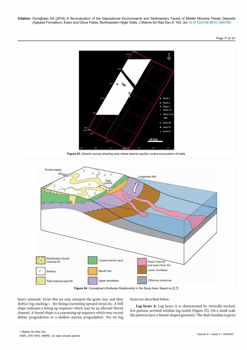
Citation: Durogbitan AA (2016) A Re-evaluation of the Depositional Environments and Sedimentary Facies of Middle Miocene Paralic Deposits (Agbada Formation), Ewan and Oloye Fields, Northwestern Niger Delta. J Marine Sci Res Dev 6: 193. doi:10.4172/2155-9910.1000193
Page 17 of 23
Volume 6 • Issue 3 • 1000193J Marine Sci Res DevISSN: 2155-9910 JMSRD, an open access journal
heavy minerals. From this we may interpret the grain size, and thus deduce log stacking i . the fining/coarsening upward trend etc. A bell shape indicates a fining up sequence which may be an alluvial/ fluvial channel. A funnel shape is a coarsening up sequence which may record deltaic progradation or a shallow marine progradation. The six log
facies are described below.
Log facies A: Log facies A is characterised by vertically-stacked, low gamma, serrated wireline log motifs (Figure 22). On a small scale the patterns have a funnel-shaped geometry. The shale baseline is given
Figure 23: Seismic survey showing area where seismic section covers and position of wells.
13000
12000
11000
10000
9000
8000
10400
10500
10750
250 260 270 290 300 310
Oloye 1
Oloye 2
Oloye 3
Ewan 12i
Ewan 5, 5a
&5b
Ewan 08
Ewan 01
Ewan 07
10 km
Figure 23: Seismic survey showing area where seismic section covers and position of wells.
Figure 24: Conceptual Lithofacies Relationship in the Study Area. Based on [2,7].
Fluvial supply
Distributary fluvialchannel fill Coastal barrier sand Slope channel
and basin floor fan
Lower shoreface
Offshore mudstone
Mouth bar
Upper shoreface
Swamp
Tidal channel sand fill
Tidalcurrent
Longshore drift
Figure 24: Conceptual Lithofacies Relationship in the Study Area. Based on [2,7].

Citation: Durogbitan AA (2016) A Re-evaluation of the Depositional Environments and Sedimentary Facies of Middle Miocene Paralic Deposits (Agbada Formation), Ewan and Oloye Fields, Northwestern Niger Delta. J Marine Sci Res Dev 6: 193. doi:10.4172/2155-9910.1000193
Page 18 of 23
Volume 6 • Issue 3 • 1000193J Marine Sci Res DevISSN: 2155-9910 JMSRD, an open access journal
at a value of 95 API. The gamma ray values for this log facies range from 20 to 35 API. This facies is sandy as revealed from the relatively low gamma ray responses (25-30 API), and commonly contain a series of relatively stacked coarsening-upward facies succession. These stacked coarsening-up units are usually less than twenty five metres thick. In this log facies, no abrupt changes were observed. The spikey gamma ray value within this interval may be caused by the presence of mica (heavy minerals) within the sandstone bodies.
This is facies was not observed within the cored interval that would allow correlation with core photos. The environment of deposition is interpreted to be a continental fluvially/tidally influenced deposits (denoted as undifferentiated continental sand in this study), the overall geometry exhibiting a coarsening-up, progradational stacking pattern.
Log facies B: Log facies B is characterised by a blocky and cleaning-upward log motif with some high serrated gamma values within the cleaning-upward sand (Figure 22). The combined thickness of this lithofacies is about 110 m. vertically stacked. The morphology of the log pattern is characterised by a funnel shape. The gamma ray values range from 20 to 80 API with the shale baseline marked at 95 API. There is abrupt change of gamma ray values within the cleaning-upward log motif, this changes may be related to lithology e . changes in mica content within the sandstone bodies. Upwardly, this lithofacies transits gradually into stacked up fluvial/tidally influence channels sands
(undifferentiated continental deposit). This is facies was not observed within the cored interval that would allow correlation with core photos Based on the log motif and stacking patterns, this lithofacies has been interpreted to be coastal barrier sand. The overall geometry is pradational.
Log facies C: This log facies is characterised by a dirtying upward log signature with a bow/bell shape and a blocky gamma ray log signature (Figure 22). This bow shape may give a clue on the position of maximum deposition which may be at the centre of the bow shape [51]. Five units of this log facies were characterized and interpreted from given gamma ray logs within the study area. They are denoted by facies C1, C2, C3, C4 and C5. The thickness of each unit is 100 m, 25 m, 20 m, 60 m and 20 m respectively. Gamma ray values range from 20-80 API. The log shape of log facies C1 and upper part of unit C4 are characterised by bow/bell shape while C2, C3 and C5 are characterised by a blocky sharp base. Gamma ray log signature anomalies, i . high gamma within this clean sand may be due high mica content within the sandstone facies.
The geometry and relationships of the basal part log facies C shows a sharp contact followed by concave-up pattern, which is interpreted to define an erosion surface. The base of units C1, C2, C3, C4, C5 are all interpreted to be a candidate sequence boundary, and apart from unit C1, all have a transgressive surface at the top. Unit C1 is cut by a major
Figure 25: Gamma ray facies association from well log pattern used in defining depositional environments within the study area [30].
Well log signatures
A
B
C1
C2-5
D
E & F
Log patterns/ motifs
Lithofacies Descriptions Lithofacies Interpretations
0 APl 150
Stacked up of bell shape (coastal barrier bar) and funnel shape (fluvi-al/tidally influence channel sand
Undifferentiated Continental deposits (Benin Fomation)
Blocky and cleaning upwards
20m
20m
20m
20m
20m
20m
Low serratedgamma
Funnel shape morphology with average thickness of about 50m bounded at the basal part by candidate sequence Boundary or transgressive surface
Coastal barrier bar
Blocky and dirtying upwards
Bow/ bell shape morphology, shows some high gamma values anormalies, the top units marked the transgressive surfaces while the basal marked the sequence boundaries.
Tidal/Fluvial channel fills
Blocky sharp base
Blocky and sharp base shape morphology, shows some high gamma anomalies within the clean sand, The top and the basal contacts correspond to transgressive surfaces and sequence boundary respectively
Slope channel/Channel sand
Gradual cleaning upwards
Funnel shape morphology and less blocky than coastal barrier bar. The upper contact is defined by the transgressive/ flooding surfaces while the basal part is defined by shallow marine deepening.
Upper shoreface sand
High serrated gamma
High serrated gamma ray values with aggrading stacking patterns this can differentiated form each other by their neutron and density log characters
Offshore mudstone/ Lower shoreface deposit
Figure 25: Gamma ray facies association from well log pattern used in defining depositional environments within the study area [30].
Citation: Durogbitan AA (2016) A Re-evaluation of the Depositional Environments and Sedimentary Facies of Middle Miocene Paralic Deposits (Agbada Formation), Ewan and Oloye Fields, Northwestern Niger Delta. J Marine Sci Res Dev 6: 193. doi:10.4172/2155-9910.1000193
Page 19 of 23
Volume 6 • Issue 3 • 1000193J Marine Sci Res DevISSN: 2155-9910 JMSRD, an open access journal
candidate sequence boundary, and probably the transgressive surface has been eroded at this location.
Correlation of this log facies with the Oloye 3 core photos at interval 1717.3-1725.5 m confirms the lithofacies as a micaceous fine-grained sandstone. Based on core sedimentology and the log stacking pattern, constrained with shoreline position from the seismic survey (Appendix), log facies C2-C5 is interpreted as slope channel sand with a possible erosive base. While log facies C1 is interpreted as tidal/fluvial channel sand with possible erosion base.
Log facies D: Log facies D1, D2, D3, D4, D5 and D6 are characterised by a cleaning-upward log motif. The average thickness of this log facies is about 40 m. The log pattern is characterised by a funnel shape. The shale baseline is given at a value of 95 API with gamma ray values ranging from 20 to 45 API, so this facies is interpreted to be sandy. There are some small gamma ray log signature anomalies i . high serrated gamma within the log facies may indicate the presence of mica or feldspars within the sandstone.
Based on correlation with core sedimentology from interval 1392.7-1395 m in well Oloye 3, which is the lateral equivalent of unit D1 in the Ewan wells, (Figure 5), this log facies has been interpreted to be a prograding-aggrading shoreface (upper-lower shoreface).
Log facies E: The log facies E1, E2, E3, E4, E5, E6 and E7 are characterised by having a sharp base and a highly serrated gamma log signature, with gamma ray values of about 90 API. The shale baseline is about 95 API (Figure 22); therefore this is interpreted as a heterolithic (muddy sandstone). The average thickness varies from well log to the other. Gamma ray log signature anomalies i . excessive high serrated gamma values within the log facies E may also indicate the mica and feldspars content within the facies.
As observed from the well logs, Maximum Flooding Surfaces are located within this log facies (Figure 22). This log facies can be correlated with core photos from Ewan 1 well, which is a lateral equivalent of Ewan 08 well (interval 1496.6-1511.5 m) (Figures 22 and 23). Based on the wireline log signatures and core descriptions, the lithofacies have been interpreted to be a muddy sandstone.
This is interpreted to be prograding shoreface (upper shoreface) and aggrading shoreface (lower shoreface) deposits that are characteristic of highstand system tracts [44]. It is observed from the well data that the sub-lithofacies Es thins seaward as observed from Oloye 3 which may imply a coastal environment/flooding event (retrogradation).
Log facies F: This log facies is characterised by a high serrated gamma ray log motif. This facies is mudstone as revealed from the relative high gamma ray responses (> or = 95 API). This log signature can be distinguished from Log Facies E as it has a higher gamma ray reading, higher that or equal to 95 API that defines the shale base line for this interpretation. The neutron and density log signature values are also higher (between 95-105 API) compared to the ones observed from Log facies E.
Where core photos are available for this lithofacies, it should be possible to differentiate from the lower shoreface by palaeoentological and petrological data. Only wells Ewan, 07, 08 and 05 penetrated this facies. The spiky gamma signature within this interval may indicate the presence of streaks and bands of siderite within the lithofacies. The sub-environment of deposition is interpreted as offshore mudstone.
Log facies distribution
In summary, from the wireline log analysis, six log facies association were identified partly constrained by core sedimentology. They are:- undifferentiated continental sand which is defined as Benin Formation, coastal barrier sand, tidal/fluvial channel- fill sand, upper shoreface, lower shoreface, slope channel sand and prodelta/offshore mudstone.
Synthesis of Lithofacies Distribution, Sedimentary Processes and Environments from Core
Description of core photographs from selected cored intervals within the studied area allows interpretation of depositional environments from specific intervals from wells Ewan 1 and Oloye 3. A detailed lithofacies classification has been established and two lithofacies associations identified. They are: slope channel sand sequences and lower-shoreface sequences (Table 1).
Slope channel sandstone
This lithofacies association in the Oloye 3 well (1718-1726 m) Figure 2, is characteristically thickly bedded (bedding about 8 m thick), fine grained and moderately to highly bioturbated with trace fossils of Skolithos, Ophiomorpha, and Planolites. It comprises poorly sorted, fine grained sandstone lithofacies SA2, SA3, SA4 and heterolithic lithofacies HE2. This unit shows a fining upward to blocky shape on gamma ray log profiles (Figure 22). Stacking pattern based on log character cross bedding structures, the presence of carbonate nodules and degree of bioturbation suggest that they were deposited by low to high energy traction currents in a shallow marine slope channel setting with some fluvial. The fluvial influence is supported by carbonaceous fragments, carbonaceous laminae recognised within the lithofacies. The overlying highly bioturbated muddy sandstone has a composite ichnofabrics of Teichichnus, Palaeophycus, Planolites (dominant), Ophiomorpha and Phoebichnus (about 2 m thick) i . at the top of sandstone faces, below the uncored intervals (Figure 2) indicate upward decrease in flow velocity as a result of channel migration, channel abandonment and/or decrease in discharge.
The large amount of carbonaceous (woody) materials within this facies may suggest a terrestrial input. However, the high preserved ichnofauna within this lithofacies suggest little or no reworking within a marine dominated environment, where there was deoxygenation caused by biological action.
The carbonate nodules and ferruginisation sometimes observed at the top of the facies (in Oloye 3) probably formed shortly after deposition (diagenetic) and indicates reducing (anoxic) conditions resulting from consumption of available oxygen by aerobic bacteria.
Environmental interpretation: The above characteristics are interpreted to record sub aqueous confined flows in a meandering slope channel setting with fluvial influence. This unit is characterised as fining upward sequence of cross bedded and fine laminated sands, with an erosional base underlain by carbonate nodules. Petrophysically, it is characterised by a blocky to fining upward profile.
Lower shoreface
The thick, highly bioturbated sandstone unit composed of fine-grained SA1, MS1, MS2, MS3, HE1, HE3 and HE4. The unit is characterised by a coarsening-upward log motif and contains ripples, wavy, planar lamination and cross stratification. The presences of wave ripples and cross lamination suggests moderate to high energy. There is also an abundance of carbonaceous materials in the sandstone facies, which can be related to terrestrial input. These sandstones are generally more compacted and cemented than above described slope channel

Citation: Durogbitan AA (2016) A Re-evaluation of the Depositional Environments and Sedimentary Facies of Middle Miocene Paralic Deposits (Agbada Formation), Ewan and Oloye Fields, Northwestern Niger Delta. J Marine Sci Res Dev 6: 193. doi:10.4172/2155-9910.1000193
Page 20 of 23
Volume 6 • Issue 3 • 1000193J Marine Sci Res DevISSN: 2155-9910 JMSRD, an open access journal
sandstones. This may reflects the finer-grained nature of the sands which allows more compaction and the availability of mud and calcium carbonate within the pore water. The alternation of parallel bedded sandstone in which burrows are rare to absent with densely burrowed zones suggests considerable variation in sedimentation rates, probably associated with storm/fair-weather deposition. Bedding is defined by thin laminae of carbonaceous material and reddish brown streaks of sandstone. The streak of sandstone reflects episodic high energy condition. Bioturbation has largely destroyed the original sedimentary structures.
Graded mudstone facies characterised generally with thin laminated basal layer are a common feature of lower shoreface-transitional zone facies [49]. Alternating thinly bedded, disrupted sandy mudstone and mudstone lithofacies within the Oloye 3 well in the upper part of the core (section above the uncored interval) in which original sedimentary structures were largely destroyed by the intensive bioturbation are interpreted to be upper shoreface environment.
Environmental interpretation: Based on the trace fossils, ichnofabric textures and the observed sedimentary structures, the interpretation of this unit reflects a lower shoreface depositional environment under storm/wave dominated conditions. Proximal mouth bars on top of delta slope deposit may be the most likely sub environment for this above described unit. They are formed in a wave dominated lower shoreface environment.
Core and Wireline Log Facies ModelCore sedimentology and wireline log analysis, constrained with
shoreline position from the seismic survey have been integrated to produce a facies scheme and interpret the depositional environment. The results are compared with that suggested by previous workers [7-11]. A summary of the new facies scheme is given in Table 1, and the depositional trend of the facies in the studied area is illustrated in Figures 2 and 24. Previous works have shown that Niger delta is an excellent example of a mixed wave, tide and fluvial deltaic system [1,52] (Figure 1), in which the prograding delta has been modified by wave action creating an arcuate coast with beach deposits, back barrier lagoons and chenier ridges. The coastline of the lower delta plain of the Niger is bordered by thick mangroves, incised into this coastline with numerous tide dominated coastal estuaries that are gradually infilling with sediment during the present-day transgressive to highstand system tract (Figure 1). Therefore, understanding the configuration of the different and complex depositional systems in modern deltaic analogues is the key for interpreting and understanding the geometries, scales and processes that formed the ancient system. The complex interplay of physical processes along the present-day Niger delta is apparent in the preserved sediments of the Ewan and Oloye fields (northwestern delta). On the field reservoir scale it is difficult to decipher the large-scale deltaic features of the Niger Delta and what is apparent are sedimentary bodies representing smaller scale distributary fluvial channel fill, tidal channel fill, coastal barrier bar, fan deposit (mouth bar sand), shoreface, slope channel fan and offshore mudstones.
Based on the core sedimentological descriptions and the wireline log interpretations, it is also proposed that the modern delta represents an excellent analogue based on its scale, depositional systems and stratigraphic setting (Figures 22 and 24). Generally, the middle Miocene succession within the studied area (northwestern Niger delta) is a complex mosaic formed by a series of discrete deltaic
deposition events at different times. The succession comprises fine grained sandstone continental deposits of delta plain facies, tidal/fluvial channel sandstones and coastal barrier bar deposits; mouth bar and shoreface sandstones of delta front facies, slope channel sand and offshore mudstone (Figure 22).
Sharp-based sandstones are interpreted as slope channel and tidal/fluvial channel sand; and gradational-based sandstones as lower shoreface deposit respectively. The slope channel and tidal channel sands are fine grained sandstone, fine-upward, and are poorly sorted, often carbonaceous, micaceous, ferruginised. The lower shoreface units are typically fine grained poorly sorted and muddy sandstone, carbonaceous, stratified ferrugineous. Interpretation from these observation shows that sands were originally deposited in river- and mouth bars, with tidal currents producing inlet channels that maintained openings along coastline. Subsequent erosion and coast parallel transport by wave and tide induced currents (longshore drift currents) lead to deposition of considerable amounts of sand along an elongated shoreface and basinal environments.
The lithofacies associations interpreted from wireline log motifs and core photographs show that middle Miocene paralic sub environments range from inner shelf to offshore (Figure 22). This agrees with previous works which showed that the Agbada Formation consists of stacked fluvial/tidal influenced channels whose main lithofacies include distributaries channel fills, levees, crevasse splays, coastal barrier bars, shoreface, slope channel/fan and offshore mudstones sediments [7-11].
DiscussionLithofacies interpretation forms the primary tool for identifying the
depositional conditions under which the sediment were deposited and preserved. Based on wireline interpretation and core sedimentological description within the studied area, it can be observed that the Niger delta prograded and regressed several times in response to fluctuation in relative sea level; and the deposits have been modified by wave and tidal processes producing a complex suite of continental deposits, beaches, and estuaries along the delta margin (Figure 1). These processes have implications on the interpretation of depositional sequences at the field scale, but on the seismic scale, the depositional model reflects the delta progradation and recession. However, on the parasequence to parasequence set scale (well log), the depositional environments comprises, continental sand, tidal/fluvial channels/mouth bar sand, coastal barrier bars, shoreface, slope channel/fan and offshore mudstone systems.
Ichnofabric analysis has proved very useful in this study to constrain the depositional processes, environments and help refine the facies model. The study of ichnofabric and the diagenetic imprint has also helped to delineate some key surfaces. For example the presence of Thalassinoides ichnofabric and diagenetic nodules within the core of Oloye 3 well. Thalassinoides is usually considered a firmground indicator in clastic substrates [53-56]. The occurrence of Thalassinoides reflects cessation of deposition, with minimal erosion (subaerial exposure) or burial and exhumation manifested by firmground formation [57]. Within this unit, firmground development seems to have occurred episodically and gradationally. It is commonly believed that sharp breaks in the vertical stratigraphic record may signify changes in depositional environment and initiation of new sedimentation cycles. However, gradational facies contacts are generally observed within the core interval. This suggests or implies a more gradual shift in depositional condition. It may be speculated that intense bioturbation could be responsible for destruction of the erosion surfaces through

Citation: Durogbitan AA (2016) A Re-evaluation of the Depositional Environments and Sedimentary Facies of Middle Miocene Paralic Deposits (Agbada Formation), Ewan and Oloye Fields, Northwestern Niger Delta. J Marine Sci Res Dev 6: 193. doi:10.4172/2155-9910.1000193
Page 21 of 23
Volume 6 • Issue 3 • 1000193J Marine Sci Res DevISSN: 2155-9910 JMSRD, an open access journal
biogenic homogenization, making the contact between the superposed facies appear gradational. The presence of carbonate nodules is interpreted to be evidence of such surfaces (sequence boundary) within the study core interval (Figure 2). The recognition of Planolites-Phoebichnus, Planolites-Thalassinoides and Planolites-Teichichnus-Phoebichnus ichnofabric within the shallow marine slope depositional environment, coupled with the differences in the three dimensional geometry morphology, wall structure (burrow infill) and sizes of Planolites and Palaeophycus-Planolites ichnofabric has provided more details about the environment of deposition within the stratigraphic interval i how stressful the environment of deposition may have been.
Marine flooding surfaces develop as a result of increasing accommodation and/or accompanied reduced sediment input into the system during a sedimentary hiatus. This produces geochemical conditions which are conducive for preservation of trace fossils a high diversity of ichnofossil and precipitation of early bacterially mediated carbonate cement for their preservation. The presence of firmground and hardgrounds should also be one of the criteria in demonstrating these surfaces, but identification of firm/hard grounds was not possible because the analysis is based on core photos.
The main controls on the development of ichnofabrics include, water turbidity, water oxygenation, nature of the relict sediment, water salinity, episodic depositional rate and storm/wave energy condition. Individual marine flooding surfaces and sequence boundary exhibit different ichnofossils colonising different environments. For example, the interpreted FS 1 (Figures 2 and 22) in upper shoreface settings is dominated by Palaeophycus and Planolites (Table 1 and Figure 2). In FS 2 (Figure 2), it is marked by Planolites and Teichichnus ichnofabric with high ichno-diversities of Planolites, Palaeophycus, Ophiomorpha, Teichichnus, Skolithos and Phoebichnus. This environment of deposition is interpreted as marine dominated slope channel/fan.
The lower shoreface complex reflect some degree of facies variability, both sedimentologically and ichnologically. This facies ranges from vertically unburrowed HCS, wavy beddings and planar lamination sandstone to thoroughly bioturbated muddy sandstone. Variability in the preserved trace fossil record may locally reflect combination of water turbidity, water salinity, fluctuating/episodic depositional rate and storm/wave energy condition. Reduced oxygenation also has a profound effect upon the trace assemblages [50,57,58] and do appear to exert a control on the facies themselves within the study area. From this observation storms and to a lesser degree, fair-weather waves are the dominant physical processes operating on the lower shoreface [59].
Wireline log stacking patterns has been used to delineate log facies associations in this study. The use of only gamma ray log stacking patterns in predicting deposition environment has posed some difficulties, but through integration of identified key surfaces within the core; constrained with shoreline position from the seismic survey, a robust constrained interpretation is obtained. The scale of facies succession is a very important criterion constraining the interpretation of the log pattern.
Difficulty in interpreting of log pattern within the study area occurs where units amalgamate e . the stacked clastic progradation continental sandstones (e . Facies A). In this case, the succession generates a continuously upward cleaning gamma ray pattern. Within facies A is not possible to easily distinguish and sub units.
From the wireline log, correlation, the trend and nature of facies variation can be observed to be lateral extensive (~10 km wide) within a stratigraphic horizon (middle Miocene). Their facies relationship can
be used to understand strata stacking patterns and to estimate lateral extent of reservoir facies. Vertically, the facies trend shows both small scale transgression and regression cycles. From observation in the study area, the geometry of major sand bodies produced in deltas is strongly related to the time of sea level fall.
The model developed within this study is similar to the existing Quaternary delta system model [7,58-60] and the coastal plain/shallow marine deposition system model of Oboh [2]. This suggests that in the studied area, the coastal barrier complex contains a large amount of sand that was originally deposited in river mouth bars, but was laterally removed by longshore current and re-deposited on the shoreline margin and basinward through developed of canyons on the basin slope which serves as a conduits for transporting sand basinward. Variability in sedimentological depositional processes within the studied area may be due to numerous variables that influence sedimentation rate (river, tide and wave), mode of deltaic sedimentation and salinity fluctuation.
ConclusionThe lithofacies, ichnofacies and depositional environments of the
middle Miocene; northwestern Niger delta has been evaluated using core photographs and well logs. Log motif analysis, calibrated by core photographs and constrained with seismic was used to define log facies associations which were used to identify stacking patterns and key stratal surfaces. Identified lithofacies associations are slope channel sand and upper-lower shoreface sequences.
The ichnofabric succession allows recognition of gradatioal transitions between ichnofabrics, the identification of stratal units, composed of genetically related ichnofabrics, and key stratal surfaces e . sequence boundary and marine flooding surfaces. Integration of core and wireline sedimentology; constrained with shoreline position from the seismic survey, have provided a depositional model for lower delta plain to offshore (prodelta) environments within a tide/wave/storm influenced delta. Within each depositional complex, some sub-environments have been differentiated through a combination of physical, ichnofabric and biogenic features. The lower shoreface complex is strongly affected by both storm and fair-weather conditions, and hence, the preserved record shows a great degree of variability. This degree of variability is attributed to variations in overall storm intensity, storm frequency and relative water depth. The marine dominated slope channel sand complex is also quite variable in terms of ichnology.
Well logs and core data indicate that the depositional environments range from inner shelf to offshore (prodelta). Constrained with shoreline position and gross depositional environment (GDE) map from the seismic survey (Appendix).
References
1. Doust H, Omatsola E (1990) In: Edwards and Santogrossi PA (Ed) Niger Delta in JD Divergent/Passive Margin Basin AAPG 48: 201-238.
2. Allen JRL (1965) Late Quaternary Niger delta, and adjacent areas- sedimentary environments and lithofacies: AAPG Bull 49: 547-600.
3. Weber KJ, Daukoru EM (1975) Petroleum Geology of the Niger Delta Proc Ninth World Petrol. Congress 2: 209-221.
4. Evamy BD, Haremboure J, Kimberling P, Knapp WA, Molloy FA, et al. (1978) Hydrocarbon habitat of Tertiary Niger delta. AAPG Bull 62: 1-39.
5. Reijers TJA (1995) Reservoir geological core description using standardised lithofacies and tier associations in the Tertiary Niger Delta. Nigerian Asso of Petroleum Explorationists Bull 10: 27- 39.
6. Idowu AO (1993) Reservoir Fluid Differentiation Case Study from an Onshore Niger Delta Fields. Nigerian Ass of Petrl Geologists 10: 157-168.

Citation: Durogbitan AA (2016) A Re-evaluation of the Depositional Environments and Sedimentary Facies of Middle Miocene Paralic Deposits (Agbada Formation), Ewan and Oloye Fields, Northwestern Niger Delta. J Marine Sci Res Dev 6: 193. doi:10.4172/2155-9910.1000193
Page 22 of 23
Volume 6 • Issue 3 • 1000193J Marine Sci Res DevISSN: 2155-9910 JMSRD, an open access journal
7. Oomkens E (1974) Lithofacies relations in the Late Quaternary Niger Delta complex. Sedimentology 21: 195-222.
8. Adedokun OA (1981) Petrology, Provenance and Depositional environment of the Reservoir Sandstone of OSSU-1ZOMBE Oilfield, Imo State, Nigeria. J of Petroleum Geology 4: 25-56.
9. Petters SW (1984) An ancient submarine canyon in the Oligocene-Miocene of the western Niger Delta. Sedimentology 31: 805-810.
10. Amajor LC, Agbaire DW (1989) Depositional history of the Reservoir Sandstones, Akpor and Apara Oilfields Eastern Niger Delta. J of Petroleum Geology 4: 453-464.
11. Oboh EA (1992) Middle Miocene palaeonvironments of the Niger Delta. Palaeogeography, Palaeoclimatology, Palaeoecology. Elsevier Science Publishers BV, Amsterdam 92: 55-84.
12. Pemberton SG, Frey RW (1982) Trace fossil nomenclature and the Planolites-Palaeophycus dilemma. J Paleont 56: 843-881.
13. Dott RH Jr, Bourgeois J (1982) Hummocky stratification: Significance of its variable bedding sequences: Geological Society of America Bulletin 93: 663-680.
14. Duke WL (1985) Hummocky cross-stratification, tropical hurricanes, and intense winter storms: Sedimentology 32: 167-194.
15. Reineck HE, Singh IB (1980) Depositional Sedimentary Environment. Springer, Berlin p: 551.
16. Pemberton SG, MacEachern JA (1995) The sequence stratigraphic significance of trace fossils: examples from the Cretaceous foreland basin of Alberta, Canada: in JC Van Wagoner and G Bertram eds. Sequence stratigraphy of foreland basin deposits- outcrop and subsurface examples from the Cretaceous of North America: AAPG Memoir 64: 429-475.
17. Pemberton SG, MacEachern JA, Frey RW (1992a) Trace fossil facies models: environmental and allostratigraphic significance: in RG Walker and NP James eds. Facies Models: Response to Sea Level Change. Geological Association of Canada, Geotext 1: 47-72.
18. Seilacher A (1981) Towards an evolutionary stratigraphy: Acta Geologica Hispanica 16: 39-44.
19. Seilacher A (1982a) General remarks about event beds: in G Einsele and A Seilacher eds., Cyclic and Event Stratification. Springer-Verlag, Berlin p: 161-174.
20. Seilacher A (1982b) Distinctive features of sandy tempestites: in G. Einsele and A. Seilacher eds., Cyclic and Event Stratification. Springer-Verlag, Berlin p: 333-349.
21. Wheatcroft RA (1990) Preservation potential of sedimentary event layers: Geology 18: 843-845.
22. Pemberton SG, MacEachern JA, Ranger MJ (1992b) Ichnology and event stratigraphy: The use of trace fossils in recognizing tempestites: in SG Pemberton ed. Application of Ichnology to Petroleum Exploration, A Core Workshop. Society of Economic Paleontologists and Mineralogists, Core Workshop Notes 17: 85-117.
23. Frey RW, Goldring R (1992) Marine event beds and recolonization surfaces as revealed by trace fossil analysis: Geological Magazine 129: 325-335.
24. Pedersen GK, Surlyk F (1983) The Fur Formation, a late Paleocene ash-bearing diatomite from northern Denmark: Bulletin of the Geological Society of Denmark 32: 43-65.
25. Seilacher A (1969) Fault-graded beds interpreted as seismites: Sedimentology 13: 155-159.
26. Seilacher A (1962) Paleontological studies in turbidite sedimentation and erosion. J of Geology 70: 227-234.
27. Aigner T (1985) Storm Depositional Systems: Berlin; Springer-Verlag p: 174.
28. Rice AL, Billett DSM, Fry J, John AWG, Lampitt RS, et al. (1986) Seasonal deposition of phytodetritus to the deep-sea floor: Royal Society of Edinburgh Proceedings 88B: 205-279.
29. Leithold EL (1989) Depositional processes on an ancient and modern muddy shelf, northern California: Sedimentology 36: 179-202.
30. Durogbitan, AA (2010) Seismic, Sequence Stratigraphic and Structural Analysis of Ewan and Oloye Fields (Middle Miocene), Northwestern Niger Delta. PhD
Thesis unpubl. Earth Science Department, The University of Manchester p: 337.
31. Taylor A, Gawthorpe RL (1993) Application of sequence stratigraphy and trace fossil analysis to reservoir description: examples from the Jurassic of the North Sea. In: Parker JR (Ed), Petroleum of Northwest Europe: Proceedings of the 4th Conference. Geological Society, London p: 317-335.
32. Taylor A, Goldring R (1993) Description and analysis of bioturbation and ichnofabric. J of the Geological Society, London 150: 141-148.
33. Taylor A, Goldring R, Gowland S (2003) Analysis and application of ichnofabrics. Earth-Science Reviews 60: 227-259.
34. Taylor A (1991) Trace Fossil Fabric Analysis in the Sub-surface Exploration of Jurassic Sequences from the North Sea Basin. University of Manchester, PhD thesis unpublished p: 489.
35. Ekdale AA (1988) Pitfalls and palaeobathymentric interpretation based on trace fossil assemblages. Palaios 3: 464-472.
36. Staff GM, Powell EN (1988) The paleoecological significance of diversity: the effect of time averaging and differential preservation on macro invertebrate species richness in death assemblages. Palaeogeogr, Palaeoclimatol., Palaeoecol 63: 73-89.
37. Goldring R (1995) In Bosense DWJ and Allinson PA (Ed) Organism and the subtrate: response and effect. Marine Palaeoenvironmental Analysis from Fossils. Geological Society, London 83: 151-180.
38. Wetzel A (1983) Biogenic structures in modern slope to deep-sea sediments in the Sulu Sea Basin (Philippines). Palaeogeogr Palaeoclimatol, Palaeoecol 42: 285-304.
39. Bromley GG, Asgaard U (1979) Triassic freshwater ichnocoenoses from Carlsberg Fjord, East Greenland. Palaeogeogr Palaeoclimatol Palaeoecol 28: 39-80.
40. Keighley DG, Pickerill, RK (1995) The ichnotaxa Palaeophycus and Planolites; historical perspectives and recommendations. Ichnos 3: 301-309.
41. Ager DV, Wallace P (1970) The distribution and significance of trace fossil in the uppermost Jurassic rock of the Boulonnais, northern France Geol J Spec Issues 3: 1-18.
42. Malpas JA, Gawthorpe RL, Pollard JE, Sharp IR (2005) Ichnofabric analysis of the shallow marine Nukhul Formation (Miocene), Suez Rift, Egypt: implication for depositional process and sequence stratigraphic evolution. Palaeogeogr Palaeoclimatol, Palaeoecol 215: 239-264.
43. Ekdale AA, Bromley RG (1984) Comparative ichnology of shelf-sea and deep-sea chalks. J Paleont 58: 322-332.
44. Walker RG, Plint AG (1992) Wave and Storm dominated Shallow Marine Systems. In Walker RG and James NP (eds). Facies Models: Response to seal level changes. Geological Assoc of Canada p: 219-238.
45. Pemberton SG (1992) Applications of Ichnology to Petroleum Exploration: A Core Workshop. SEPM (Society of Economic Paleontologists and Mineralogists), Core Workshop No. 17, Calgary p: 429.
46. Galloway WE (1968) Depositional Systems in the lower Wilcox group, North-Central Gulf Coast basin. Gulf Coast Soc Trans 18: 275-289.
47. Fishers WL (1969) Facies characterisation of Gulf Coast basin delta systems with some Holocene analogues. Gulf Coast Soc Trans 21: 239-261.
48. Coleman JM, Prior DB (1982) Deltaic environment. In: Scholle PA, Spearing D (Ed.) Sandstone Depositional Environment. American Assc of Petr Geol. Memoir 31: 139-178.
49. Selley RC (1978) Concepts and methods of subsurface facies analysis: American Association Petroleum Geologists, Continuing Education Course Notes Series 9 p: 82.
50. Escalona A, Mann P (2006) Sequence-stratigraphic analysis of Eocene clastic foreland basin deposits in central Lake Maracaibo using high resolution well correlation and 3-D seismic data. AAPG Bull 90: 581-623.
51. Emery D, Myers KJ (1996) Sequence stratigraphy: Oxford, Blackwell Science p: 297.
52. Allen JRL (1970) In: J.P Morgan (Ed.) Sediments of the modern Niger delta: a summary and review. Deltaic Sedimentation. Modern and Ancient. SEPM Spec Publ 15: 138-151.

Citation: Durogbitan AA (2016) A Re-evaluation of the Depositional Environments and Sedimentary Facies of Middle Miocene Paralic Deposits (Agbada Formation), Ewan and Oloye Fields, Northwestern Niger Delta. J Marine Sci Res Dev 6: 193. doi:10.4172/2155-9910.1000193
Page 23 of 23
Volume 6 • Issue 3 • 1000193J Marine Sci Res DevISSN: 2155-9910 JMSRD, an open access journal
53. Seilacher A (1964) Sedimentological classification and nomenclature of tracefossils. Sedimentology 3: 253-256.
54. Pemberton SG, Frey RW (1985) The Glossifungites ichnofacies: modern examples from the Georgia coast, USA. In: Curran HA (Ed), Biogenic structures: their use in interpreting depositional environments, Spec Publ Soc Eon Paleontol Mineral 35: 237-259.
55. Mac Eachern JA, Raychaudhuri I, Pemberton SG (1992) In. Pemberton, SG. (Ed.) Stratigraphic applications of the Glossifungites ichnofacies: Delineating discontinuities in the rock record. Application of Ichnology to PetroleumExploration, a core workshop, Soc Econ Paleontol Mineral Core Workshop 17: 169-198.
56. Gingras MK, Pemberton SG, Saundners T (2001) Bathymetry, sedimenttexture and substrate cohesiveness; their impact on modern Glossifungites
trace assemblages at Willapa Bay, Washington. Palaeogeogr Palaeoclimatol Palaeoecol 169: 1-21.
57. Bromley RG, Ekdale AA (1984) Chondrites: a trace fossil indicator of anoxia insediments. Science 224: 872-874.
58. Ekdale AA, Bromley RG (1984) Sedimentology and ichnology of theCretaceous-Tertiary boundary in Denmark: implications for the causes of theterminal Cretaceous extinction. J of Sedimentary Petrology 54: 681-703.
59. Greenwood B, Mittler PR (1985) Vertical sequence and lateral transitions in thefacies of a barred nearshore environment: Journal of Sedimentary Petrology55: 366-375.
60. Weber KJ (1971) Sedimentological aspect of oil fields in the Niger Delta. GeolMijnbouw 50: 559-576.