i · pdf filerancho bernardo community plan ... p.o. box 85271-230, san diego, ca 92138 ......
TRANSCRIPT
- i -

- i -
RANCHOBERNARDOCOMMUNITY PLAN
Printed on recycled paper.
This information, or this document (or portions thereof), will be made available in alternative formats upon request.

- ii -
RANCHO BERNARDO COMMUNITY PLAN
The following amendments have been incorporated into this February 2007 posting of this Plan:
AmendmentDate Approved
by PlanningCommission
ResolutionNumber
Date Adopted byCity Council
ResolutionNumber
Rancho BernardoCommunity Planapproved.
February 2, 1978 1176 March 28, 1978 R-220568
Preserve existing scale andcharacter of RanchoBernardo and approvewidening of RanchoBernardo Road.
October 6, 1988 R-0270-PC December 18, 1988 R-272586
Redesignate a parcel ofBernardo Heights Parkwayfrom private recreation tolow-density residential.
November 14, 1989 R-274733
Redesignate 5.7 acresfrom industrial tospecialized commercial.
July 29, 1997 R-289015
Redesignate 34.46 acresfrom agricultural toresidential land use.Modify the boundaries ofareas designated foragricultural, residentialand open space to allowthe proposed Saddle ClubEstates development.
January 11, 1999 R-291151

- iii -
MAYOR
Maureen O’Connor
CITY COUNCIL
Abbe WolfsheimerRon RobertsGloria D. McCollWes PrattEd StruiksmaBruce HendersonJudy McCartyBob Filner
CITY ATTORNEY
John W. Witt
CITY MANAGER
John Lockwood
PLANNING COMMISSION
Karl ZoBell, ChairmanLynn BennChris CalkinsAlbert KerchevalYvonne LarsenPaul OquitaRalph Pesquiera
PLANNING DEPARTMENT
Robert P. Spaulding, Planning DirectorMichael Stepner, Assistant Planning DirectorMary Lee Balko, Deputy DirectorBill Levin, Senior PlannerJames L. Overstreet, Project PlannerLeo DeJesus, GraphicsPeggy Cooper, Word Processing

- iv -
This Plan that follows has been prepared with the cooperation of the following groupsand individuals. The Planning Department extends special thanks to these groups andindividuals for their valuable input and time commitments in the planning process.
RANCHO BERNARDO UPDATE COMMITTEE
Dr. Ora Peckham, ChairpersonGary A. KreitzerCharles J. JacobsJ. E. (Ed) MatsonThomas W. Bilhorn
RANCHO BERNARDO COMMUNITY PLANNING BOARD
The Planning Board was formed under City Council Policy600-24 to advise the City on long-range planning issues.
Irving Rosen, ChairmanThomas W. Bilhorn, Vice-ChairmanClayton Morehead, SecretaryMel D. Compton, Treasurer
Phyllis Johnson Mirian SherrardJohn J. Tucka Carrol A. BadeauDavid R. Wilkins Robert C. MitchellRamona Salisbury Robert C. ParsonsJohn Maloney C. H. ZondagRobert P. Dahlquist Kenneth LewellynRaymond K. Locke Howard FreyenseeVictoria Touchstone David W. PhelpsLaurence B. Henkin Paul ZimmerTom Parsons

- v -
P.O. Box 85271-230, San Diego, CA 92138
Dear Community Resident:
The goal of the Rancho Bernardo Community Planners is a Plan which provides for thehealth, safety and welfare of the existing and future residents and maintains the area as adesirable community in which to live.
The Plan is a cross section of community opinion and desires blended with professionalknowledge and sound planning policy. Throughout many months, volunteer members of theCommunity Planning Board met with the City Planning Department staff in workshops withrepresentatives of various City, School and State Departments. Many ideas and conceptswere considered and refined to meet the needs of the community, some were rejected. ThePlan presented is a comprehensive, long-range policy guide for the Rancho BernardoCommunity. It discusses residential, commercial, industrial, open space, circulation, andcommunity facilities in terms of existing conditions, states projected needs, objectives andproposals for each.
We hope you will take advantage of the detailed information to better understand thesuggestions for the future of the community. For the Plan to serve as a useful document,statements were made as precise as possible. Tables, charts, etc., were included wherenecessary for explanation and reference. The end result does give the Plan a technicaltextbook appearance, but it makes material available where and when it is needed. TheRancho Bernardo Community Plan is simply a first step in the never ending desire of thecitizens to participate in the design of their community. We are grateful for your interest inthe community and hope you will continue to actively support and participate in thecommunity planning process.
Respectfully,
RANCHO BERNARDO COMMUNITY PLANNING BOARD

- vii -
INTRODUCTIONScope and Purpose of This Plan ............................................................................................1The Planning Area ................................................................................................................2Legislative Framework..........................................................................................................3Planning Background ............................................................................................................4Existing Development - 1988 ................................................................................................5
OVERALL PLANNING GOALS AND GENERAL DEVELOPMENT PROPOSALSPlanning Goals......................................................................................................................9General Development Proposals..........................................................................................10
COMMUNITY PLAN ELEMENTSHousing and Residential Land Use Element ........................................................................13Commercial Element...........................................................................................................21Industrial Element ...............................................................................................................29Circulation Element ............................................................................................................31Community Facilities Element ............................................................................................47Open Space, Parks and Recreation Element.........................................................................53
IMPLEMENTATION ELEMENTIntroduction ........................................................................................................................61Generalized Implementation Process Recommendations .....................................................61Summary of Plan Proposals.................................................................................................67
RANCHO BERNARDO COMMUNITY PLAN MAPRancho Bernardo Community Plan Map .............................................................................72
Figure 1. Location Map ......................................................................................................xFigure 2. Residential Areas – Land Use Density Designations ..........................................12Figure 3. Undeveloped and Developing Residential Areas ................................................14Figure 4. Commercial Areas .............................................................................................20Figure 5. Community Plan Implementation Overlay Zone ................................................25Figure 6. Industrial Areas .................................................................................................28Figure 7. Functional Street System at Buildout .................................................................32Figure 8. 1987 Average Daily Traffic ...............................................................................34Figure 9. Traffic Forecast at Buildout ...............................................................................36Figure 10. Traffic Signals ...................................................................................................38Figure 11. Bicycle and Equestrian Trails.............................................................................40Figure 12. Facilities Classifications ....................................................................................42Figure 13. Community Facilities.........................................................................................48Figure 14. Open Space, Park and Recreation Proposals.......................................................54

- viii -
Table 1. Summary of Residential Proposals ....................................................................... 18Table 2. Land Use Recommendations: Summary ............................................................... 73

- x -
FIGURE 1. LOCATION MAP

- 1 -
INTRODUCTION
SCOPE AND PURPOSE OF THIS PLAN
The Rancho Bernardo Community Plan (Plan) has been prepared to serve as a guide forfuture public and private development within the area through 1995, or until it is fullydeveloped. Once this Plan is adopted by the City Council, any amendments, additions ordeletions, will require that the Planning Commission and City Council follow the samepublic hearing procedure as was required in the initial adoption of the Plan. While this Plansets forth many proposals for implementation, it does not establish new regulations orlegislation, nor does it rezone property. However, it must be clearly pointed out that adoptionof this Plan may require subsequent public hearings be held to determine whether or not torezone property so that it is consistent with Plan proposals. This requirement for consistencybetween zoning regulations and adopted plans is set forth within Section 65860 of theCalifornia Governmental Code. The amendment of other development controls must also beenacted separately through the regular legislative process. It should also be understood thatthis Plan is not precise in every minute detail and reasonable interpretation of this Plan,which may cause minor adjustments, is expected.
Proposals within this Plan have been coordinated with the City of San Diego Progress Guideand General Plan (General Plan). There is conformity between the goals and policies of thisPlan and those of the City and region. Should differences occur between this Plan and theGeneral Plan, they may be resolved during the course of related public hearings. Thisprocedure conforms to the intent of City Council Policy 600-7.
In addition, periodic comprehensive reviews of the General Plan may producerecommendations for changes in this Plan. Again, the normal procedure for legislative action,including public hearings, must be followed before changes to either of these documents canbe accomplished. Future development based on this Plan shall be undertaken in compliancewith all existing City policies and all applicable City ordinances with respect to providingnecessary public facilities.
During Plan preparation, the relationship with planning programs and development patternsin surrounding areas was considered. This analysis included coordination with the adoptedSan Pasqual and Rancho Peñasquitos Community Plans, and surrounding land uses.Proposals of the San Diego Association of Government's Regional Comprehensive Plan andthe adopted San Diego County General Plan have also been considered. The Plan is not anend in itself, nor is it a static document. Two additional steps will follow Plan adoption:implementation and review. Implementation means putting the Plan policies andrecommendations into effect. The Plan provides guidelines for implementation, but the actualwork must be based on a cooperative effort of private citizens, developers, City officials andother agencies. This Plan is intended to be a development guide for the future. Communityconditions and the legislative framework must be continually monitored to ensure that thePlan remains timely. If major Plan amendments are necessary, they would follow the samelegislative process required for adoption.

- 2 -
THE PLANNING AREA
Rancho Bernardo is the northernmost residential community within the City of San Diego. Itis centered on Interstate 15 (I-15) just south of Lake Hodges and the San Pasqual Valley. Thecommunity planning area encompasses about 6,511 gross acres consisting of:1) approximately 6,107 gross acres containing the developed Rancho Bernardo communityand other adjacent land proposed for development originally under the ownership of AvcoCommunity Developers Inc., and 2) 404 gross acres of adjacent City-owned lands lying inthe northwest quadrant of the plan area, west of I-15. The existing Rancho Bernardocommunity and properties can be developed independently of the other areas; however, theirclose physical relationship dictates an integrated planning approach. For lands lying outsidethe planning area it was assumed that:
1. The San Pasqual Valley will be maintained as a permanent open space areacharacterized by agricultural and recreational uses developed in accordance with theadopted San Pasqual Valley Area Plan.
2. The rugged hills and topographic breaks along the westerly and southwesterlyboundaries of the Plan area will act to provide open space separations betweenRancho Bernardo and adjacent lands thus giving definition to the community.
3. The Poway General Plan will provide for low-density residential, rural-residential,and commercial office uses within areas lying adjacent to the easterly boundary ofRancho Bernardo.
4. The Carmel Mountain Ranch Community Plan designates the area south of RanchoBernardo and east of I-15 for industrial, commercial and residential land uses.
5. On the west side of I-15 and south of the Rancho Bernardo boundary, the Planprovides for primarily low-density residential land use.

- 3 -
LEGISLATIVE FRAMEWORK
The planning process must respond to a number of laws enacted at federal, state and locallevels. Some of the more significant legislation is discussed as follows:
• Section 65450 of the Government Code of the State of California, and Section 41(c) of theCharter of the City of San Diego give authority for the preparation of community plans.More specifically, Section 65450 states, “After the legislative body has adopted a generalplan, the planning agency may, or if so directed by the legislative body shall, preparespecific plans for the systematic implementation of the general plan for all or part of thearea covered by the general plan.” Sections 65451 through 65454 of this law define theScope, Implementation and Administration of Specific Plans and Regulations.
• The California Environmental Quality Act of 1970 (CEQA) was enacted in response toincreasing public concern over the environment. In a 1972 landmark case, Friends ofMammoth et al. vs. Board of Supervisors of Mono County et al., the California SupremeCourt ruled that Environmental Impact Reports, (EIRs) must be prepared for both publicand private projects having a significant effect on the environment. Environmental ImpactReports must be prepared for all community plans. Separate, detailed EIRs are alsorequired for all significant projects, including those implementing this Plan.
• The citywide Zoning and Subdivision Ordinances serve to regulate the use of land. Theseare amended from time to time to resolve problems as they are identified, enhance theenvironment and encourage imaginative approaches to development design.
• In addition to legislation, the City Council utilizes a set of officially designated andnumbered policies as a guideline in the decision-making process. Many of the policiesrelate directly to planning issues and should be used in implementing Planrecommendations. These are discussed within the Implementation Element of this Plan.

- 4 -
PLANNING BACKGROUND
In 1962, the San Diego City Council adopted the original Plan for Rancho Bernardo. Sincethen, the Plan has undergone revisions in 1966, 1971 and 1978. The two early revisions weremade based upon findings of coordinated public agency and community developer planningstudies. Shifts in land use involved agreements between developers and the City. In 1978, theformat of the Plan was changed to that of a community plan rather than a development plan.The revisions recognized the changing character and growth in the community as reflected inthe quickening tempo of development and increased diversity in land use, population andlifestyles.
The revisions included in this document represent the fourth update of the Plan and areconsidered essential if the Plan is to continue to serve as an effective guide to public andprivate development decisions. The Plan that follows respects existing patterns ofdevelopment while incorporating the five amendments to the Plan since the 1978 revision, aswell as new data from recent studies of environmental, economic, land use and transportationfactors.
The following is a synopsis of the amendments to the Plan since its adoption in 1978.
The San Diego City Council adopted the Plan on March 28, 1978, by City CouncilResolution No. 220568.
On March 16, 1981, by Resolution No. 253790-1, the City Council unanimously approved anamendment in the southern portion of the Plan to redesignate 30 acres of residentially-designated land to industrial use.
The City Council, on June 16, 1981, adopted an amendment by Resolution No. 254458 that:
1) redesignated an elementary school site east of I-15 and north of Bernardo Center Drive tolow-medium density residential use (nine to 14 dwelling units per net acre),
2) redesignated an elementary school site in the southeast quadrant of the planning area tolow-density residential use (one to nine dwelling units per net acre), and
3) revised the proposed residential and open space land uses in the Westwood area withoutan increase in residential density.
On March 9, 1982, by Resolution No. 255968, the City Council approved an amendment tothe Circulation Element to the Plan. This amendment included the following revisions:
1) the deletion of Escala Drive extension under I-15 to West Bernardo Drive,
2) the extension of West Bernardo Drive to Pomerado Road as a four-lane major street, and
3) the extension of Bernardo Center Drive as a six-lane major street and Rancho BernardoRoad as a four-lane major street to the western boundary of the Plan area.

- 5 -
The City Council, on April 1, 1986, adopted by Resolution No. 265356, an amendment to thePlan to redesignate the elementary school site at the southeast corner of the intersection ofPomerado Road and Escala Road to low-density residential use (one to nine dwelling unitsper net acre).
On March 3, 1987, the City Council approved by Resolution No. 267821, an amendment tothe Plan to redesignate the proposed intermediate school site and one elementary school sitein the Westwood Valley area to low-density residential use (one to nine dwelling units pernet acre). All amendments are on file in the office of the City Planning Department.
EXISTING DEVELOPMENT - 1988
Rancho Bernardo is characterized by rolling hills, ridges and knolls rising from valley andcanyon floors. While some areas to the south drain into La Jolla Canyon, most lands aretributary to the San Pasqual Valley. Vegetation outside of developed areas is largely confinedto range grasses which historically supported cattle grazing within the Rancho. Geologically,there are five distinct formations lying below the soil mantle. They vary from friable claylayers and conglomerates to hard, dense igneous and metamorphic rocks.
Approximately 4,560 net acres, or 70 percent of the Plan area, have been developed with amix of recreational, residential, commercial and industrial uses.
Residential uses currently occupy about 2,437 net acres and consist of about 13,854dwellings. Approximately 7,975 of these dwellings are single-family homes with theremainder in multifamily residential developments. The average residential densitydeveloped within the community is 5.7 dwelling units per net acre excluding streets and openspace.
Commercial activity is concentrated around the town center located in the vicinity of RanchoBernardo Road and Bernardo Center Drive. Approximately 44 acres of the 53-acre towncenter have been developed with a variety of uses including a major food market, drug store,numerous retail commercial businesses, service and financial institutions and a retirementfacility. Approximately 55 acres of the area west of Bernardo Center Drive are developedwith a diversity of uses such as a post office, library, fire station, theatre, financialinstitutions, auto service centers, restaurants and a hotel. An additional seven acres offinancial institutions and restaurants are located to the south on Bernardo Center Drive eastof the I-15 off-ramp.
Five neighborhood commercial centers have also been developed in the community. One islocated at Rancho Bernardo and Pomerado Roads and consists of six acres. It is the site of amajor food store, a hardware store and other various service establishments. Four otherneighborhood commercial centers provide convenience goods and services to thecommunity. They include a one-acre center on Oaks North Drive just east of PomeradoRoad, a six-acre center at Duenda Road and West Bernardo Drive, a six-acre center atPomerado Road and Bernardo Heights Parkway and a two-acre site in the High CountryWest area near the intersection of Maturin Drive and Bernardo Center Drive.

- 6 -
Specialized commercial areas include visitor-oriented and special community-servingcommercial activities. In Rancho Bernardo, these uses are located in the vicinity of theI-15/Rancho Bernardo Road interchange and include such uses as motels, restaurants, servicestations and retail shops. There are significant lodging, convention, restaurant, entertainmentand recreation facilities in the Compri Hotel and the Rancho Bernardo Inn.
Industrial activity in Rancho Bernardo occupies 618 acres located in two industrial parks.Bernardo Industrial Park, located on the west side of I-15 between Rancho Bernardo Road,Bernardo Center Drive and Camino del Norte, contains approximately 588 acres. Major userssuch as UNISYS (Burroughs Corporation), National Cash Register, Hewlett Packard andSony Tomura Electric, along with numerous industrial support activities, occupy about 370acres.
The other industrial park, Bernardo Heights Corporate Park, occupies approximately 30 acresand is located southeast of the intersection of I-15 and Camino del Norte. Currently, themajor user at this location is Gould Electronics, which occupies approximately 5.4 acres.


- 9 -
OVERALL PLANNING GOALS AND GENERAL DEVELOPMENT PROPOSALS
PLANNING GOALS
Plan goals are designed to give direction to future growth and development. They also linkthe past to the present and future by providing a sense of continuity between the originalconcept of a New Town, the reality of today and the prospects for the future. Most of thefollowing goals were originally stated in the first Plan document. They are:
1. Preserve and enhance the high quality and character of the Rancho Bernardo community,including its neighborhood identities.
2. Develop the community's image as an important housing, employment, trade andrecreational center.
3. Develop an attractive community that takes advantage of natural and man-made amenitieswhile respecting the environmental assets and constraints inherent in the Rancho Bernardosetting.
4. Ensure a balanced community. Provide for a wide variety of housing types, densities, unitsizes and prices, with densities consistent with the Plan designations and aestheticallycompatible with the surrounding neighborhood.
5. Provide areas for shopping, service and community facilities that are closely related andeasily accessible to community residential areas.
6. Provide a circulation system to safely and adequately accommodate traffic within thecommunity and establish linkages with other planned metropolitan road systems.
7. Provide adequate schools, parks and community facilities integrated with a planned openspace system.
8. Support utilization of crime prevention techniques such as neighborhood alert units andcrime-free design techniques.

- 10 -
GENERAL DEVELOPMENT PROPOSALS
The Plan Goals outlined above cannot happen by themselves. Development proposals mustbe formulated and acted upon to accomplish the desired end. The General Developmentproposals listed below have been designed and are being implemented to accomplish the PlanGoals. They include:
1. Provide for a community focal point. An intensive commercial development complexlocated in the vicinity of the I-15/Rancho Bernardo Road interchange provides this focus.The Bernardo Town Center brings together, in an integrated design, those shopping,office, institutional, medical, entertainment and other community facilities necessary tomeet diverse community needs. Areas westerly of the Town Center and Bernardo CenterDrive accommodate a variety of uses including public facilities, offices, sites for highway-oriented commercial activity and other specialized commercial establishments. While theBernardo Town Center and related areas will accommodate higher intensity uses, sitedevelopment should continue to be characterized by low-profile structures, not exceedingthree stories in height and incorporating open space areas.
2. Provide a wide variety of housing. Housing types, ranging from detached, single-familyhomes through cluster housing and townhouses to medium-density apartments areidentified in the Plan. Residential complexes are designed to meet varying needs andlifestyles in the community. Many are oriented toward recreational facilities andenvironmental features, while others are clustered in close proximity to the Town Center,neighborhood commercial centers and the industrial park complex.
3. Ensure that convenience shopping centers, schools, recreational areas and institutionalfacilities are closely integrated with neighborhoods and housing complexes. Open spacesystems provide excellent opportunities for visual and circulation linkages betweenneighborhoods, commercial, recreational and other activity centers. Parts of the systemshould extend to the San Pasqual Valley regional open space area.
4. Design a circulation system that provides for “safe” internal community trafficmovements, links with adjacent communities and provides adequate access to the freewaysystem in the area. Topographic conditions have been respected in balancing the allocationof use areas and the design of supporting traffic systems. Forced development of arterialsand collectors through rugged topography has been avoided in order to minimize costlyand unsightly cuts and fills and to avert future development problems in highway-adjacentareas.
5. Housing located along segments of I-15 should be separated from the adverse effects offreeway traffic by horizontal and vertical breaks, as well as through site planning,landscaping, construction techniques, air conditioning and interior design.

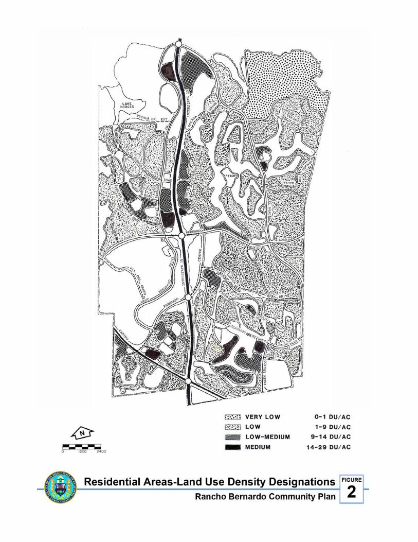
FIGURE 2. RESIDENTIAL AREAS – LAND USE DENSITYDESIGNATIONS

- 13 -
HOUSING AND RESIDENTIAL LAND USE ELEMENT
EXISTING CONDITIONS – 1988
Approximately 2,937 acres of the Rancho Bernardo community are proposed for residentialdevelopment. The Plan proposes a mix of housing types and densities to provide suitablehousing for all segments of the community. When fully developed, Rancho Bernardo willhouse a projected population of about 41,200 people in approximately 17,900 dwellings.
Approximately 33,250 people live in Rancho Bernardo presently. About 2,437 acres, or 83percent of the designated residential area, have been developed with more than 13,854 unitsfor an average density of 5.7 units per net acre.
Some 7,975 of the existing dwellings are single-family detached homes located onapproximately 1,882 acres. These homes serve as the core of the Rancho Bernardo residentialcommunity. The remaining 5,879 units consist of a mix of single-family attached homes,condominiums and apartment units on about 554 acres and built to an average density of 10.6units per acre. These higher density neighborhoods serve a diverse population expressing avariety of lifestyles and needs. Existing and proposed developments of this nature areclustered around commercial and community centers with good access to major streetsystems.
RESIDENTIAL OBJECTIVES
• To develop a high quality residential environment.
• To encourage a housing inventory consisting of a wide variety of housing types andprices.
• To utilize imaginative concepts in residential construction. Crime-free design techniquesand high quality hardware should be promoted in all new construction.
• To maintain the existing quality and character of Rancho Bernardo in all newdevelopment.
• To create and maintain a residential community adequately served by public facilities,commercial and industrial establishments and a balanced transportation system.
• To encourage innovative housing design and siting, to provide reasonable land utilizationand at the same time optimize the usable open space within the density limitationsproposed in the Plan.
• To encourage residential design which will provide optimum interior and outdoor privacyand protection or screening from external noise.

- 14 -
FIGURE 3. UNDEVELOPED AND DEVELOPING RESIDENTIALAREAS
- 15 -
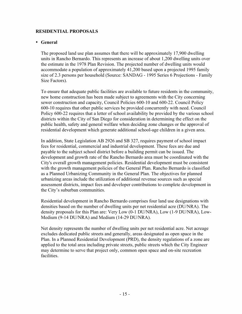
RESIDENTIAL PROPOSALS
• General
The proposed land use plan assumes that there will be approximately 17,900 dwellingunits in Rancho Bernardo. This represents an increase of about 1,200 dwelling units overthe estimate in the 1978 Plan Revision. The projected number of dwelling units wouldaccommodate a population of approximately 41,200 based upon a projected 1995 familysize of 2.3 persons per household (Source: SANDAG - 1995 Series 6 Projections - FamilySize Factors).
To ensure that adequate public facilities are available to future residents in the community,new home construction has been made subject to agreements with the City concerningsewer construction and capacity, Council Policies 600-10 and 600-22. Council Policy600-10 requires that other public services be provided concurrently with need. CouncilPolicy 600-22 requires that a letter of school availability be provided by the various schooldistricts within the City of San Diego for consideration in determining the effect on thepublic health, safety and general welfare when deciding zone changes or the approval ofresidential development which generate additional school-age children in a given area.
In addition, State Legislation AB 2926 and SB 327, requires payment of school impactfees for residential, commercial and industrial development. These fees are due andpayable to the subject school district before a building permit can be issued. Thedevelopment and growth rate of the Rancho Bernardo area must be coordinated with theCity's overall growth management policies. Residential development must be consistentwith the growth management policies of the General Plan. Rancho Bernardo is classifiedas a Planned Urbanizing Community in the General Plan. The objectives for plannedurbanizing areas include the utilization of additional revenue sources such as specialassessment districts, impact fees and developer contributions to complete development inthe City’s suburban communities.
Residential development in Rancho Bernardo comprises four land use designations withdensities based on the number of dwelling units per net residential acre (DU/NRA). Thedensity proposals for this Plan are: Very Low (0-1 DU/NRA), Low (1-9 DU/NRA), Low-Medium (9-14 DU/NRA) and Medium (14-29 DU/NRA).
Net density represents the number of dwelling units per net residential acre. Net acreageexcludes dedicated public streets and generally, areas designated as open space in thePlan. In a Planned Residential Development (PRD), the density regulations of a zone areapplied to the total area including private streets, public streets which the City Engineermay determine to serve that project only, common open space and on-site recreationfacilities.

- 16 -
• Very Low-Density Development (0-1 DU/NRA)
Extremely low densities are proposed in the Trails area where large acreage lots willpermit the keeping of horses. This area is located in the northeasterly portion of thecommunity overlooking the San Pasqual Valley. Approximately 280 lots are proposed tobe located within the Trails development which will contain some 369 acres. To beconsistent with the plan-adopted density for this area, the existing A-l-l zoning should beretained.
• Low-Density Development (1-9 DU/NRA)
Approximately 2,103 acres are proposed for development at low-residential densities. Asthe single largest land use category, low-density residential accounts for about 32 percentof the total area in the Rancho Bernardo community. The allocation of land is based on acombination of factors including physical environment and the capacities of proposedcirculation and utility systems. The existing R1-5,000 and R1-20,000 zones in RanchoBernardo accommodate this land use designation.
While the densities in areas with these zones vary from 1-9 DU/NRA, the low-densitydesignation has been developed at an average density of 5.3 DU/NRA. The existingdensity should be maintained to ensure preservation of the existing character of thecommunity.
Dwelling units in low-density areas should be characterized by single-family detachedstructures on lots meeting or exceeding standard dimensions. However, this should notprohibit imaginative design concepts where a number of single-family dwellings aregrouped in two, three or four unit structures or designed as clusters. These types ofdevelopment can be accommodated through the City's Planned Residential DevelopmentOrdinance. Such development however should be confined to hillsides, rugged terrain andareas with sufficient adjoining open space to maintain an overall low density. As a majorland use pattern, low-density residential development is well distributed throughout thecommunity. It should be noted that all such areas are proposed to have access or adjacencyto planned open space and recreational areas.
• Low-Medium-Density Development (9-14 DU/NRA)
The Plan sets aside approximately 369 acres for development of residential units atdensities from 9-14 DU/NRA. The density assigned to this land use conforms to theR-3000 zone. These areas have developed at an average overall density of 10.4 DU/NRA.This density should be maintained to ensure preservation of the existing character of thecommunity.
This area affords the developer a unique opportunity to be both flexible and creative inwhat is designed. A wide variety of housing types and site designs can be accommodated.Such units can be conventional detached single-family dwellings and attached single-family dwellings in structures of two, three or four units. Clustered, detached dwellings,

- 17 -
patio houses and townhouses can also be accommodated within the low-medium-densitydevelopment range. PRD permits are encouraged in these density ranges.
Low-medium-density areas can take advantage of environmental settings by maximizingopen space areas, minimizing grading, preserving environmentally prominent featuressuch as hills, knolls and natural rock outcroppings and environmentally sensitive areassuch as natural watercourses and riparian areas. Low-medium-density areas may also takeadvantage of view areas on ridges and lands with frontage on, or in close proximity to,open space systems and recreational areas. Development of townhouses or clusterdevelopment on ridges would offer special development advantages over conventionalsubdivision techniques. Grouped dwellings, institutional facilities and retirement facilitiescan be designed to optimize view potentials. Site preparation should be confined to ridgesrather than spread to adjoining canyons or draws. Architecturally pleasing design andridge profiles should be established. Such development, however, should be sensitive tothe visual impact of the project on the community. Developments should be aestheticallypleasing when viewed up close or from afar. Development on cropped hilltops andvisually prominent or unsightly silhouettes should be avoided. In addition, great care mustbe given to the project’s design to ensure that the project is compatible with that of thesurrounding neighborhood. This is particularly important for multi-story developments.With these considerations in mind, selective use of low-medium-density dwellings incertain areas may permit better environmental design and respect for landforms thanwould be possible if lower density, detached single-family units were constructedthroughout a greater area.
• Medium-Density Development (14-29 DU/NRA)
About 96 acres are allocated for rental or condominium development within a densityrange consistent with the R-1500 zone of 14 to 29 DU/NRA. An average density of 20DU/NRA should be maintained. In order to ensure project designs that are consistent withthe quality of development throughout the community and to ensure that the averagedensity in these areas does not exceed 20 DU/NRA, PRD permits are recommended forany projects with a density that exceeds 14 DU/NRA. The allocation of land is projectedto meet future demands for housing by small families, couples and individuals. Increasingemployment opportunities in industrial, office, retail, service and governmental sectors ofthe community economy will heighten the demand.
Apartments are necessary not only for new residents but also for community residentswhose family composition and housing needs shift over time. An example of this type ofdevelopment is the Casitas Apartments located north of Rancho Bernardo Road and westof I-15. It consists of 368 units developed to a density of 18 DU/NRA. Apartmentdevelopments have been planned for areas closely related to shopping, office andrecreational complexes. These sites have good accessibility to the regional andinter-community transportation systems. Emphasis has been placed on locating medium-density developments in ways that will minimize walking and vehicular travel times tocommunity activity centers.

- 18 -
Multifamily developments should reflect the community character. Their design should bein keeping with the design theme of Rancho Bernardo. It is recommended that suchdevelopments be processed as PRDs in order to ensure design compatibility with thesurrounding community. Through the PRD process, recreational facilities and open areasshould be required in all apartment and multifamily projects. While apartment units maybe designed largely for the rental market, some medium-density projects should providefor condominium ownership.
TABLE 1SUMMARY OF RESIDENTIAL PROPOSALS
DENSITY PROPOSALS NET AREA NO. OF DWELLINGS
Very Low-Density: 0-1 DU/NRA 369 280
Low-Density: 1-9 DU/NRA 2,103 11,430
Low-Medium Density: 9-14 DU/NRA 369 4,110
Medium-Density: 14-29 DU/NRA 96 2,080
Total 2,937 acres 17,900 units
The total number of residential units in the planning area should not exceed approximately17,900 units as described in Table 1. Residential properties shall not exceed the densitiesfor which they have been approved in the adopted 1988 Plan. Residential properties shallnot exceed the number of dwelling units permitted as of April 1988 by approvedsubdivision maps or PRD permits for these properties. Revisions or amendments to thesemaps and permits which propose to increase the number of residential units beyond thepreviously approved total (per Table 1 above) should not be approved. Figure 3 indicatesthe number of residential units approved for each of the residentially-designated areasthroughout Rancho Bernardo which had not been completed as of April 1988. Anyproposal to exceed the number of dwelling units indicated on Figure 3 will be consideredcontrary to the intent of this Plan and should be denied.
In the event that a Plan amendment removes an area from the residential designation, theproposed dwelling units for that property shall be deducted by that amendment from thetotal dwelling unit count for the community. Transferring of dwelling units to otherprojects will not be permitted.
Included in the Implementation Element are procedures for monitoring the number ofunits for which final approval is given and for ensuring that the total unit count ofapproximately 17,900 is not exceeded without an amendment to this Plan.
• Balanced Community
One of the primary goals of the Plan is to foster a community that provides equalopportunity in housing. To accomplish this, efforts should be made to explore thefeasibility of various housing programs and to implement them so as to meet growingdemands for lower cost housing.

- 19 -
Efforts should be made to supply apartments, townhouses, single-family dwellings andother housing types to satisfy a broad range of consumer preferences and budgets.Housing complexes should be adapted to physical conditions and developed to takeadvantage of existing amenities.
• Retirement Housing Facilities
Two retirement care facilities have been established in Rancho Bernardo to serve the twoadult communities and large population of senior citizens in the community. TheRemington Club, located on Acena Drive, is a retirement community consisting of 146dwelling units and a 59-bed skilled nursing facility. The Casa de las Campañas is a lifecare retirement center consisting of 426 units and a 99-bed care facility located on WestBernardo Drive, north of the Westwood area, overlooking Lake Hodges. A thirdretirement care facility is planned on the eight-acre site adjacent to and north of theRemington Club. This new facility will consist of 100 dwelling units and a 100-bedassisted care facility. The Remington Club and the new facility are located in the TownCenter Commercial Area under a Conditional Use Permit (CUP). These retirementhousing facilities provide a level of sheltered living that was once lacking in RanchoBernardo.
Retirement housing projects should be compatible with the existing neighborhood andshould be evaluated as to height, bulk, scale, setback, open space, landscaping, parkingand architectural quality. Projects that are not compatible and contain structures thatoverwhelm other buildings, open spaces and natural landforms, block views and/or disruptthe community's character, should not be permitted.
- 20 -
FIGURE 4. COMMERCIAL AREAS

- 21 -
COMMERCIAL ELEMENT
EXISTING CONDITIONS - 1988
The Plan designates 204 acres for commercial uses ranging from a 53-acre Town Center toseveral neighborhood shopping centers conveniently located within the community. The areadesignated for commercial use represents approximately three percent of the total land areain the Plan.
Presently, 187.5 acres have been developed for commercial use. The largest concentration isin the vicinity of Rancho Bernardo Road and Bernardo Center Drive where there areapproximately 108 acres developed. Development on the Town Center site consists of ashopping center, restaurants, financial and institutional uses and a retirement facility.
Specialized commercial uses and business office complexes are oriented toward visitor andspecial community activities and have easy access to I-15. These uses include banks, savingsand loans, service stations, a hotel, post office, fire station, branch library and telephoneexchange. The Mercado, located on a 7.5-acre lot north of Bernardo Center Drive andRancho Bernardo Road, includes retail shops and restaurants.
A five-acre commercial site at West Bernardo Drive and Rancho Bernardo Road has beendeveloped with a service station, a restaurant and a motel. A motel, restaurant and threeservice stations occupy 5.5 acres in the industrial area south of Rancho Bernardo Road. Ahotel is planned on a 3.5-acre site on West Bernardo Court. These freeway-oriented facilitiesprovide food and lodging to persons conducting business in the community. Development inthe Town Center and surrounding specialized commercial areas continues.
A corporate office complex has been developed on a 20-acre parcel located north of theMercado between I-15 and Bernardo Center Drive. This complex has been sensitively sitedon a prominent knoll within the community.
Five neighborhood commercial centers on 21 acres presently serve the community. One,located at Rancho Bernardo and Pomerado Roads, consists of six acres and offers a variety ofcommercial goods and services, including a major food store. A 1.3-acre neighborhoodcenter providing convenience goods is located on Oaks North Drive just east of PomeradoRoad. A six-acre neighborhood center has been developed west of I-15 on West BernardoDrive. A six-acre site at Bernardo Heights Parkway and Pomerado Road is developed with anassortment of commercial establishments including neighborhood retail uses, financialinstitutions, restaurants and a major food store. A fifth neighborhood center is located on atwo-acre site at Bernardo Center Drive and Maturin Drive.

- 22 -
COMMERCIAL OBJECTIVES
• To accommodate commercial retail and office uses that serve the community, as well asprovide an employment base for area residents.
• To provide commercial facilities necessary to serve the needs of travelers and visitors tothe area.
• To design commercial developments so as to incorporate attractive lighting, landscapedparking, screening of loading and service areas, architecturally compatible buildings andto provide safe and convenient bicycle and pedestrian access to these facilities.
• To provide a focal point for the community in the town center and to encourage a mix ofcommercial, office, financial, governmental, entertainment and cultural uses.
• To encourage commercial facilities to be designed so as to reduce the potential forcriminal activity.
• To ensure that any redevelopment of commercial retail or office use is sensitive to theneeds and conditions of the community.
COMMERCIAL PROPOSALS
• Bernardo Town Center
The 53-acre Town Center should function as a focal point for the Rancho Bernardocommunity. It should accommodate a diverse array of facilities and services including:
- A community shopping area devoted to stores and shops providing groceries,convenience and other shoppers’ goods;
- Personal, professional and financial service establishments;
- Restaurants and entertainment centers;
- Public and semi-public institutions and cultural and social facilities; and
- Two residential retirement facilities consisting of 246 dwelling units, a 59-bed skillednursing facility and 100 assisted care units.
The zoning on the Town Center site should be changed from CA-S to CA-RR. The CA-RR zone permits development of community and regional commercial uses by right whilepermitting residential uses only if a Planned Commercial Development (PCD) permit isobtained. Application of the CA-RR zone to the Town Center would, therefore, ensurethat residential uses could not be developed without an opportunity for the PlanningDepartment and the Rancho Bernardo Community Planning Board to review a residential
- 23 -
proposal and participate in a public hearing on the merits of the proposal. However, theCity would be under no obligation to approve proposals for any additional residential unitsin the Town Center if the CA-RR zone were applied to this property. The CA-RR zone isnecessary to prevent residential uses from usurping land needed for commercial uses toserve the community. Residential development, which is permitted by right in the existingCA-S zone, could exceed the projected total unit count for this community and couldstrain roadways and other public services.
While the Bernardo Town Center will draw trade from outside the community, it is notintended to be a full-fledged regional center. Shopping facilities should offer depth,variety and choice in various lines (e.g., wearing apparel), but should not be dominated bymajor department stores and large appliance and automotive establishments. Thedevelopment should be characterized by shops and establishments which meet the diverseneeds and tastes of community residents rather than the demands of large regionalmarkets.
The Town Center is centrally located and provides a focus to the community. It hasexcellent accessibility to the community circulation system, as well as to the interchangesof I-15. Direct access to the site is available from Rancho Bernardo Road, BernardoCenter Drive and Lomica Drive. The perimeter of the site is developed and landscaped tocomplement adjacent residential areas. Within the site, building areas are oriented tointerior pedestrian movements through malls, plazas or paseos or toward view potentials.Site planning accommodates parking, interior circulation and landscaping criteria within alow-profile architectural development concept. Emphasis should continue to be placed onachieving a mix of uses capable of sustaining lively day and evening activities.
• Specialized Commercial Development
Commercial areas which accommodate visitor-oriented, commercial-recreation andspecial community-serving commercial activities are grouped in one land use category. Ingeneral, these use areas provide sites for establishments that are primarily highway-oriented and serve a trade area extending beyond the community. The Plan allocates 112acres to specialized commercial uses.
The zoning in the specialized commercial areas east of I-15 should be changed from CA-Sto CA-RR for the reasons stated in the Town Center discussion in this Plan. Application ofthe CA-RR zone would help to ensure that the commercial uses in this area would not beusurped by residential development. Residential development should not be permittedunder any circumstances on the specialized commercial areas west of I-15. These areasshould be preserved for commercial-recreation and special community-servingcommercial uses. The CR and CV zones should be retained in these areas.
Existing development is centered around the I-15/Rancho Bernardo Road interchangearea. Visitor-oriented uses (motels, restaurants, service stations) are primarily located onthe west side of the freeway in the vicinity of Rancho Bernardo Road and West BernardoDrive. In this area, establishments have good access and visibility to regional routes and

- 24 -
are well located to serve the industrial park. Significant hotel, convention, restaurant,entertainment and recreational facilities are located east of I-15 at the Compri Hotel andthe Rancho Bernardo Inn complex. Other visitor-oriented uses are provided within theMercado shopping area and in connection with restaurant development in the TownCenter.
The specialized commercial area lying between I-15 and Bernardo Center Drive providesfor such uses as automobile agencies, furniture stores, commercial-recreation facilities,financial institutions, offices, clinics and similar establishments. Most of these facilitiesprovide essential community services while also serving an extended trade area.Development in these areas should not occur without recognizing the functionalrelationships and visual effects such development would have on adjacent use areas andarterials.
A privately-developed park has been provided in association with the specializedcommercial development west of Bernardo Center Drive. This area, known as Webb Park,is well integrated with the commercial development and includes a small lake. This4.63-acre private park is an important amenity in the commercial area and should beretained. For many years, the park has provided a visual amenity and an outdoor activityarea for the users of the commercial facilities surrounding it. Any future developmentplans for this area should include this open area as an important element of the designconcept.
The development standards of the underlying commercial zone do not provide sensitivesite design guidelines which would ensure preservation of a park-like environment on theWebb Park site if future redevelopment is proposed for this property. In order to ensurethat development of the site will retain an open, park-like character, a Community PlanImplementation Overlay Zone (CPIOZ), Type B should be applied to the property. TheCPIOZ permit should require the preservation and enhancement of the park-likeatmosphere and ensure that redevelopment be in conformance with all the guidelines ofthe PCD Ordinance (see Figure 5).
As the needs of the community and the region change, and/or the needs of the businesseschange, these specialized commercial developments may expand or redevelop. Proposalsfor expansion or redevelopment should be processed in association with PCD permits toensure the incorporation of appropriate uses into the project, as well as to provide forcommunity-wide review of design, compatibility with adjacent uses and potential impactsto the circulation system.
• Office Development
While professional and business offices should locate within the Town Center and othercommercial areas within the community, a regional office complex of 20 acres has beendeveloped north of the Mercado between I-15 and Bernardo Center Drive. This area isintended for use by corporate offices wishing to locate within the community. Thedevelopment at this site is characterized by two and three-story buildings in a campus-like

- 25 -
environment. Expansion or redevelopment of the existing facilities should maintain theoverall characteristics of the existing development. The area is well served by thecirculation system and has close proximity to the Town Center, major communityfacilities, the industrial park and adjacent higher-density housing areas.
The existing development occupies a prominent knoll adjacent to I-15 and is visible frommany areas within the community. As a result of the site’s visual prominence, it isimportant that any redevelopment of the site preserve the topographic character of theknoll, as well as retain the open, uncluttered nature of the site. Such sensitive site design isnot guaranteed through the development standards of the underlying CO (CommercialOffice) zone. Under the existing CO zone the property could redevelop with a permittedresidential density of 29 DU/NRA. This would be inconsistent with the densities in thesurrounding neighborhood. The intended use for this site is business and professionaloffice use. These uses should not be preempted by residential uses. The CO zone alsopermits development at a scale and bulk that could conflict with the character and visualamenities of the neighborhood. In order to ensure compatibility with the surroundingneighborhood, to enhance and preserve the scale and character of the neighborhood, and topreclude residential uses, discretionary review of development is necessary. Therefore, theCPIOZ should be applied to the property. (See Figure 5)
Figure 5. Community Plan Implementation Overlay Zone
- 26 -
The CPIOZ will establish guidelines for review relating to architectural design, buildingscale, site coverage, permitted uses, landscaping, trip generation, parking, signage androof treatment for the purpose of preserving the visual quality of the site. The Type BCPIOZ permit procedure (Municipal Code Section 101.0457.2) would require adiscretionary development permit and a public hearing process for an expansion orredevelopment on this property. The Type B CPIOZ development permit would berequired to address the following issues:
1. Architectural Design: The proposed development should include a building design thatis compatible in style, as well as in terms of bulk and scale, with surroundingdevelopments in the area. The maximum height of the buildings should also bedetermined based on compatibility with surrounding development, as well as the visualprominence of the site. Development should be consistent with the design, landscapingand signage guidelines of this Plan.
2. Site Planning: Buildings should be sited so as to complement the existing topographyand provide landscaped setbacks (minimum of 50 feet) adjacent to I-15 and BernardoCenter Drive. Site development should continue to be characterized by low-profilestructures not exceeding three stories in height and incorporating open space areas. Acampus-like environment should be maintained by fully integrating site planning,architectural and landscape design considerations into a unified development proposal.Vehicular access should be aligned to complement the existing topography. Vehicularuse areas should be sited to minimize their visual prominence.
Due to the necessity of maintaining a campus-like environment and the height andsetback limitations, it should not be assumed that the maximum site coverage and floorarea ratio permitted by the underlying zone would be permitted. However, use ofunderground or structured parking may make it possible to achieve these maximums.
3. Permitted Uses: The Plan designates this site for commercial office uses. However,other commercial uses may be considered, through a PCD Permit, provided it can bedemonstrated that there are adequate facilities (including transportation facilities)available to serve the proposed development and that the uses can be provided withoutcompromising the overall site design. Residential development on this site should beprohibited. This is the only site in Rancho Bernardo that is designated and zonedspecifically for commercial office use. This site is needed to provide for business andprofessional offices and should not be preempted by residential uses.
4. Landscape Architectural Design: Landscape design should address, but not be limitedto, the following:
• Views of the site from Bernardo Center Drive, I-15 and all other significant vantagepoints within one-half mile;
• Views from the site;
• The natural character of the site;
• The architectural style and function of proposed structures;
• The existing design character of the surrounding community.
- 27 -
Specifically, street frontages (public and private) shall be designed with street trees in aparkway. Views of parking areas from public rights-of-way should be effectivelyscreened and plantings within parking lots shall meet or exceed the requirements of theCitywide Landscape Ordinance. For purposes of water conservation, extensive use ofturf grass shall be avoided.
5. Signage: Signage on the site should be limited to two monument signs; one locatedadjacent to I-15 and the other adjacent to Rancho Bernardo Road.
6. Roof Treatment: All rooftop equipment shall be completely screened from view. Roofdesign should be consistent with that of the surrounding community.
• Neighborhood Centers
The Plan identifies five neighborhood shopping centers to meet the daily convenienceneeds of local residents. While sites should customarily contain six usable acres, the exactsizes were determined on the basis of specific planning considerations. The fiveneighborhood centers in the Rancho Bernardo community consist of 21 acres and range insize from six acres to one acre.
Typically single-story in construction, the centers provide ample parking, landscaping andscreening of service areas and show design sensitivity in relationship to adjacentresidential areas. While these sites may be located at intersections of arterial or collectorstreets, they must be convenient to local neighborhoods.
Since the neighborhood centers provide necessary services to the community, they shouldnot be preempted by noncommercial uses. Residential development in the neighborhoodcenters should not be considered as an acceptable land use and proposals for residentialdevelopment on any of the neighborhood commercial sites should be denied.

- 28 -
FIGURE 6. INDUSTRIAL AREAS

- 29 -
INDUSTRIAL ELEMENT
INTRODUCTION
The Plan sets aside approximately 612 net acres for the development of two industrial parks.Bernardo Industrial Park, the larger site, consists of 588 acres, excluding streets and thoseareas considered to be specialized commercial. This industrial park, located south of RanchoBernardo Road and west of I-15, is, for the most part, topographically separated from theadjacent community. Substantial development of manufacturing, distribution and researchand development facilities within the park has already taken place. Major firms includingNational Cash Register, UNISYS (Burroughs Corporation), Sony Tomura Electric andHewlett Packard, along with numerous smaller firms and industrial support facilities, haveacquired and developed individual sites containing a total of 370 acres.
The second industrial area, containing approximately 30 acres, is the Bernardo HeightsCorporate Park located southeast of the I-15 and Camino del Norte intersection. Currently,14 acres have been developed. The major user in this park is Gould Electronics, located onabout 5.4 acres.
These industrial parks presently employ a combined total of approximately 8,100 persons.
INDUSTRIAL OBJECTIVES
• To establish two viable industrial parks consisting of large and small industrial firmsengaged in a wide variety of non-polluting industrial activities.
• To protect the designated industrial areas from encroachment by non-industrial uses byprohibiting residential uses and non-ancillary uses in industrially-designated areas.
• To discourage the development of industrial operations which would create heavy trucktraffic in adjacent streets and highways.
• To encourage the establishment of labor-intensive industry to broaden the employmentbase in the community.
• To provide a pleasant working environment through performance standards and criteriarelated to architectural and site design.
• To provide environmental protection to adjacent residential property through site designmeasures.

- 30 -
INDUSTRIAL PROPOSALS
The industrial lands presently vacant are proposed to be used for research and developmentfacilities, manufacturing establishments and ancillary industrial activities commensurate withmodern electronics and advanced technologies. While major users will occupy relativelylarge acreage sites, areas are proposed for smaller firms, incubator industries, day care centerand recreational facilities, mini-warehouses and recreational vehicles and other suchestablishments providing support services to major residents of the industrial park and thecommunity. Appropriate industrial zoning which will accommodate special services such asmini-warehouses should be allowed, provided that it can be demonstrated that there is acommunity need for such special services. Further, such uses in the industrial area should beminimized to ensure adequate acreage for purely industrial park development. It isrecommended that any development proposals within the industrial areas that would not beregulated by the M-IP zone should be processed with a Planned Industrial Development(PID) permit to ensure site development that is consistent with the strict standards of theM-IP zone.
The industrial parks in Rancho Bernardo contribute significant acreage to the total industrialmarket for technology-based industry in the North City area. As a result, these industrially-designated lands should be protected from encroachment by non-industrial uses. Someencroachment has already occurred in the vicinity of West Bernardo Court. No furthererosion of the industrially-designated areas should be permitted. Development of theBernardo Industrial Park should continue to be controlled through performance standards andcriteria related to architectural and site design, parking, access, landscaping and signs asrequired by the M-IP zone.
It is estimated that the industrial parks will eventually employ as many as 13,000 workers.This assumes an average employment density of 21 workers per acre. When fully developed,the industrial parks in Rancho Bernardo should contain one of the largest concentrations ofhigh technology industrial employment in San Diego County.

- 31 -
CIRCULATION ELEMENT
INTRODUCTION
The basic purpose of a circulation system is to provide for safe and convenient movementwithin a community and access to points beyond its boundaries, all without unduecongestion. This requires a fully integrated transportation system incorporating automotive,transit, bicycle, pedestrian and parking facilities that allow the individual a choice of modesof travel.
The existing circulation system in the Rancho Bernardo community is a complexinterconnection of local, collector and major streets and an expressway joined at four pointsto the regional transit corridor known as I-15. Council Policies 200-1 and 600-4 identify sixclassifications of streets, including: freeway, expressway, primary arterial, major street,collector street and local street. These categories are defined as follows:
1. Freeway: Freeways, which are under the jurisdiction of the State Department ofTransportation, have full access control with full grade separation, ramp connections andare usually four lanes or more divided roadways. Their primary purpose is the longerdistance movement of traffic. Interstate 15 serves this purpose for the Rancho BernardoCommunity. Access to and from I-15 is provided at four freeway interchanges within thecommunity. The most southerly, at Camino Del Norte, provides access to both industrialsites and to the High Country West residential area. The Bernardo Center Driveinterchange provides access to the Town Center area. The most central and heavily usedinterchange is located at Rancho Bernardo Road in the heart of the community. The fourthand most northerly interchange is located at Pomerado Road. This point serves north andsouthbound traffic.
2. Expressway: A divided highway whose only purpose is to carry through traffic and toprovide a network connecting to the State Highway System. An expressway has fullcontrol of access and may have grade separations at selected intersections. Expresswaysare located so as to serve travel demand corridors that exceed the vehicle-carryingcapacity of an arterial street. Camino Del Norte functions as an expressway in RanchoBernardo.
3. Primary Arterial: A six-lane divided highway with some access control and possibly gradeseparations. Its main function is to carry through traffic and to provide a networkconnecting to the State Highway System. At the present time there are no streets in theplanning area that are performing as, and are classified as a primary arterial.
4. Major Street: A four- or six-lane divided highway designed to interconnect major activityareas in the city and to provide a network connecting to the State Highway System.Providing direct access to abutting property is a secondary function. Several streets withinthe community are presently functioning, and are classified as majors. An example isBernardo Center Drive.

- 32 -
FIGURE 7. FUNCTIONAL STREET SYSTEM AT BUILDOUT
- 33 -
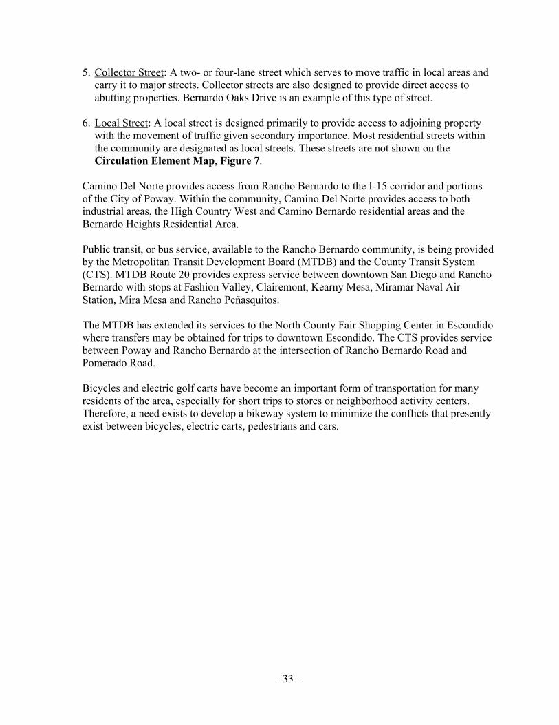
5. Collector Street: A two- or four-lane street which serves to move traffic in local areas andcarry it to major streets. Collector streets are also designed to provide direct access toabutting properties. Bernardo Oaks Drive is an example of this type of street.
6. Local Street: A local street is designed primarily to provide access to adjoining propertywith the movement of traffic given secondary importance. Most residential streets withinthe community are designated as local streets. These streets are not shown on theCirculation Element Map, Figure 7.
Camino Del Norte provides access from Rancho Bernardo to the I-15 corridor and portionsof the City of Poway. Within the community, Camino Del Norte provides access to bothindustrial areas, the High Country West and Camino Bernardo residential areas and theBernardo Heights Residential Area.
Public transit, or bus service, available to the Rancho Bernardo community, is being providedby the Metropolitan Transit Development Board (MTDB) and the County Transit System(CTS). MTDB Route 20 provides express service between downtown San Diego and RanchoBernardo with stops at Fashion Valley, Clairemont, Kearny Mesa, Miramar Naval AirStation, Mira Mesa and Rancho Peñasquitos.
The MTDB has extended its services to the North County Fair Shopping Center in Escondidowhere transfers may be obtained for trips to downtown Escondido. The CTS provides servicebetween Poway and Rancho Bernardo at the intersection of Rancho Bernardo Road andPomerado Road.
Bicycles and electric golf carts have become an important form of transportation for manyresidents of the area, especially for short trips to stores or neighborhood activity centers.Therefore, a need exists to develop a bikeway system to minimize the conflicts that presentlyexist between bicycles, electric carts, pedestrians and cars.

- 34 -
Figure 8. 1987 Average Daily Traffic

- 35 -
TRANSPORTATION OBJECTIVES
The primary goal for the Rancho Bernardo transportation system is THE SAFE, ORDERLY,EFFECTIVE, EFFICIENT AND CONVENIENT MOVEMENT OF PEOPLE AND GOODSWITHIN THE COMMUNITY AND TO PROVIDE ACCESS TO THE REGIONALTRANSPORTATION SYSTEM. In the past, developing communities have relied almosttotally on the automobile. However, a transportation system designed primarily for theautomobile cannot meet the total transportation needs of Rancho Bernardo or the San Diegoregion. While other transportation modes are needed, autos and buses are expected to remainthe dominant mode of urban mobility. The auto circulation system will be determinedprimarily by travel demands generated by the intensities and allocations of the land useswithin the community and the surrounding fringe areas. The following objectives are addedfor further definition of the primary Circulation Element goal.
• To regard transportation facilities as an integral part of the landscape in which they aresited.
• To provide a system that minimizes areas of conflict between pedestrians, bicycles andmotor vehicle traffic while adequately serving all three transportation modes.
• To provide aesthetically pleasing transportation facilities with landscaped medians as adesign element on major streets. Landscaped medians should conform to EngineeringDepartment policies and practices.
• To provide a coordinated system of transportation that will safely and efficientlyaccommodate traffic generated within Rancho Bernardo and minimize negative impactsfrom adjoining communities.
• To avoid single-family housing fronting and deriving access from major streets.
• To ensure that project approvals are conditioned upon provision of noise mitigationmeasures to achieve compatibility with existing and projected land uses.
• To minimize the environmental impact of street construction.
• To provide for effective utilization of public transit facilities and services coordinated withregional transit services to provide convenient travel within Rancho Bernardo andthroughout the region.
STREET AND TRANSIT PROPOSALS
The existing transportation network provides Rancho Bernardo with an acceptable level ofservice. The proposed improvements to the system will maintain an acceptable level ofservice as the community continues to develop.

- 36 -
FIGURE 9. TRAFFIC FORECAST AT BUILDOUT

- 37 -
Development of the system has been based on vehicular traffic assignment for thecommunity which reflect the land use designations of this Plan. Basic factors consideredwere population, employment, development characteristics, topographic considerations and atrip generation and distribution analysis of both the community and the region. Thecirculation system is based on roadway development concepts which will achieve desirablelevels of service for the community.
More specific proposals are as follows:
• Bernardo Center Drive: Widen to a six-lane major street from north of West BernardoDrive to Camino del Norte.
• Bernardo Center Drive: Construct a median from the intersection with West BernardoDrive to I-15.
• Bernardo Center Drive: Improve to six-lane major street from I-15 to north of LomicaDrive within existing right-of-way by narrowing median and prohibiting parking. Dualleft-turn lanes may require additional right-of-way at intersections.
• Bernardo Center Drive: Install a traffic signal interconnect from Rancho Bernardo Road toBernardo Heights Parkway to coordinate the stoplights along Bernardo Center Drive.
• Bernardo Center Drive: Construct a six-lane major street between the westerly communityboundary and Camino del Norte.
• Rancho Bernardo Road: Install a traffic signal interconnect from West Bernardo Drive toBernardo Center Drive to coordinate the stoplights along Rancho Bernardo Road.
• Rancho Bernardo Road: Widen a portion of Rancho Bernardo Road to a six-lane majorstreet from an area approximately 150 feet easterly of Bernardo Center Drive to an areaapproximately 150 feet westerly of West Bernardo Drive. Any replacement costs ordamage repairs, whether landscaping or otherwise, incurred during the construction of theimprovements, particularly in the medians, will be a cost of the improvements and not atthe cost or expense of the Maintenance District. In addition, any improvements would besubject to prior approval of the precise improvement plans by the Rancho BernardoPlanning Board or its successor entity.
• West Bernardo Drive: Widen to a four-lane major street between Andanza Way and I-15.
• Camino del Norte: Widen and otherwise improve to a six-lane expressway. Provide aninterchange at Bernardo Center Drive.
• Duenda Road: Construct as a two-lane collector from its westerly terminus at MatinalCircle to the future Poblado Road.

- 38 -
FIGURE 10. TRAFFIC SIGNALS

- 39 -
• Poblado Road: Complete improvements to two-lane collector from Matinal Road tonortherly terminus at Carranza Drive. Construct as a two-lane collector from CarranzaDrive to the future Duenda Road.
• Rancho Bernardo Road: Widen to a four-lane major street west of Matinal Road to thewesterly community boundary.
• Via del Campo: Restripe to three-lane collector.
• West Bernardo Drive: Restripe to four-lane major street between Rancho Bernardo Roadand Andanza Way. Street or intersection widenings should proceed only after trafficstudies indicate a need for such improvements and should be constructed in such a manneras to minimize the loss of olive trees and on-street parking.
STUDIES AND GENERAL RECOMMENDATIONS
• Interstate 15: Caltrans should study possible improvements to the interchange at I-15 andCamino Del Norte.
• Interstate 15: Caltrans should study the addition of a half-diamond interchange at DuendaRoad for entrance to I-15 in the northbound direction and exit from I-15 in the southbounddirection.
• Interstate 15: Caltrans should study and program the improvements needed at theI-15/Pomerado/ Highland Valley Road interchange.
• Development in the Future Urbanizing Area (La Jolla Valley and 4-S Ranch) should becarefully monitored in order to minimize its potential impacts on Rancho Bernardo Roadand the need for a grade separated interchange at the Camino Del Norte/Bernardo CenterDrive intersection.
• Caltrans should continue to monitor future growth within the I-15 corridor and providehigh occupancy vehicle (HOV) lanes on I-15 when they are appropriate for the RanchoBernardo area.
• The City should continue to monitor the necessity for street widening at majorintersections for dual left-turn lanes, right-turn lanes and/or through lanes to provide andmaintain an acceptable level of service. See the Functional Street System map forlocations, Figure 7.
• Proposals for street widening at intersections and the Average Daily Trip count should bereviewed periodically by the City and the Rancho Bernardo Planning Board to promoteimprovements in traffic circulation commensurate with development in the communityand the adjoining areas.
- 40 -
FIGURE 11. BICYCLE AND EQUESTRIAN TRAILS

- 41 -
PUBLIC TRANSIT FACILITIES
• Expansion of public transit service to the community should be encouraged. Frequentexpress bus service on the I-15 corridor should be maintained.
The San Diego Association of Governments (SANDAG), the designated regional Planningagency for San Diego County, is engaged in the planning of a regional public transitsystem for the San Diego Region. SANDAG has adopted a Regional Transit Plan whichincludes a transit corridor along I-15 through the Ranch Bernardo community. TheMTDB, however, will be refining and conducting additional studies related to thedevelopment of a fixed-rail system and expanded bus services. The fixed-rail system inconjunction with extended local and express bus service would eventually provide goodpublic transit throughout the region.
• Consideration should be given to development of park-and-ride facilities within theRancho Bernardo community. This concept allows the commuter to drive, be driven, orride a bicycle to a low-cost or no-cost suburban parking site and board an express transitvehicle to major urban activity centers. Park-and-ride facilities should be considered forsites shown in the MTDB’s Short Range Transit Plan. The Planning Department and theRancho Bernardo Planning Board should work with MTDB on an ongoing basis todetermine locations for park-and-ride facilities.
• The Metropolitan Transit Development Board and the CTS should continue to reexamineand modify existing bus routes on an annual basis. The concern for energy conservation,higher fuel cost and clean air provide strong stimuli for more transit usage. The MTDBhas responded to these needs by increasing bus service and realigning routes to serve morepeople at a greater level of efficiency.
TRAFFIC SIGNALS
Traffic signals should be provided and installed as development progresses to ensure thehighest degree of traffic safety and reasonable traffic flow.
Currently, a total of 42 traffic signals have been identified as needed in Rancho Bernardo and28 have been installed. Signal lights are financed by 1) developers through the subdivisionprocess; 2) a traffic signal charge as a condition of a subsequent tentative map approval and;3) the City Capital Improvements Program in the developed areas. The proposed and existingtraffic signals are shown on Figure 10.
All traffic signals in Rancho Bernardo should have bicycle-sensitive detectors installed so asto be able to detect bicyclists, especially in left-turn pockets.
Consideration should be given to adding traffic signals along West Bernardo Drive at theentrance to the Casa de Las Campañas retirement facility and either Aquamiel Road orEscala Drive Extension when it is completed.
Traffic Engineering requirements for installation must be met before traffic signals areinstalled at these or any other locations in the Rancho Bernardo area.

- 42 -
FIGURE 12. FACILITIES CLASSIFICATIONS

- 43 -
BIKEWAYS
The increased usage of bicycles throughout San Diego County has created the demand for acoordinated bikeway system. This system will include bike lanes striped within the roadwayand separate facilities constructed outside the roadway-bike paths. In response to this demandthe City Council adopted a citywide bikeway system for inter-city travel on March 15, 1973.Local communities were requested to expand the system by developing local bikeway plansfor their respective communities. On August 18, 1983, the Rancho Bernardo CommunityPlanning Board in liaison with the City adopted a revised Bikeway Element for RanchoBernardo. The bike plan discussed below and exhibited on Figure 11 is a revision to the1983 plan.
The Master Bikeway Plan for the City of San Diego is in the process of being revised. Therevised Bikeway Plan proposes improved bikeways to business districts, improved bikewaysigning and a combination of bike racks and lockers at major activity centers. The RanchoBernardo bikeway system should be reviewed for conformance with the revised MasterBikeway Plan when adopted.
BIKEWAY CLASSIFICATIONS
Generally speaking, local bikeways refer to all facilities that explicitly provide bicycle traveland can range from fully separated facilities to a simple signed street. These bikeways canutilize existing streets that connect parks, open space and schools to the residential areas andto the citywide system. The City recognizes three categories of bikeways which are definedand applied to Rancho Bernardo as follows:
1. Class I Bike Path - A completely separated right-of-way designated for the exclusive useof bicycles. There are no facilities of this type planned for Rancho Bernardo.
2. Class II Bike Lane - A restricted right-of-way designated for the exclusive or semi-exclusive use of bicycles. Crossflows by motorists and pedestrians may be allowed. Thefollowing Class II bike lanes are proposed for Rancho Bernardo in the Master BikewayPlan.
Pomerado Road: From the I-15 interchange south to the intersection with Pomerado Court,then from Rios Road south to the City limits.
Bernardo Center Drive: Southwesterly from the intersection with Bernardo HeightsParkway, under I-15, to intersection with West Bernardo Drive and beyond (eventual linkto Peñasquitos as shown on Figure 11).
West Bernardo Drive: Entire length from I-15 interchange on the north to interchange withBernardo Center Drive to the south. This will require interaction with the San DiegoPolice Department to permit parking adjacent to the Westwood Community Center onthose occasions when special events suggest the advisability of maximizing parkingavailability.

- 44 -
Rancho Bernardo Road: Westerly from the eastern city limits to the intersection withPomerado Road and westerly from Bernardo Center Drive to the western city limits.
Bernardo Heights Parkway: Westerly from the intersection with Pomerado Road to theintersection with Bernardo Center Drive.
Duenda Road: Westerly from Bernardo Center Drive to the intersection with WestBernardo Drive.
Paseo Lucido: Northerly from the Rancho Bernardo community limits to the intersectionwith Bernardo Heights Parkway.
Camino del Norte: Westerly from the southern Rancho Bernardo community limits to thewestern city limits.
Interstate 15: Northerly from Pomerado Road beyond the northern city limits to ViaRancho Parkway in Escondido. Bicyclists are allowed to use the freeway shoulders tocross Lake Hodges because no parallel alternative route to I-15 exists. Interstate 15 isunder Caltrans jurisdiction.
3. Class III Bike Route - A shared right-of-way designated as such by signs placed onvertical posts or stenciled on the pavement. The following Class III bike lanes areproposed for Rancho Bernardo in the Master Bikeway Plan.
Lomica Drive: Westerly from Pomerado Road on Higa Place, south on Gabarda Road tothe intersection with Lomica Drive, westerly on Lomica Drive to the intersection withBernardo Center Drive.
Avenida Venusto: From the intersection with Bernardo Heights Parkway southerly andeasterly to the intersection with Paseo Lucido; north on Paseo Lucido to the intersectionwith Bernardo Heights Parkway.
Via del Campo: Northerly from the intersection with West Bernardo Drive to theintersection with Rancho Bernardo Road.
Matinal Road: Northerly from the intersection with Rancho Bernardo Road to theintersection with Poblado Road.
Poblado Road: Westerly from West Bernardo Drive to eventual intersection with DuendaRoad.
Duenda Road: Westerly from West Bernardo Drive to the intersection with Poblado Road.
Aguamiel Road: Northerly from the intersection with Duenda Road to the intersectionwith West Bernardo Drive.
Paseo del Verano Norte: Easterly from the intersection with Pomerado Road to theintersection with Paseo Del Verano.

- 45 -
Paseo del Verano: Easterly from the intersection with Pomerado Road to the intersectionwith Paseo Del Verano Norte.
Bernardo Center Drive: Northerly from the intersection with Bernardo Heights Parkway tothe intersection with Duenda Road.
Rancho Bernardo Road: Westerly from Pomerado Road to the intersection with BernardoCenter Drive.
Greens East Road: Westerly from the intersection with Pomerado Road to its terminus atthe Rancho Bernardo Inn.
Escala Drive: Northerly from the intersection with Duenda Road to the intersection withPomerado Road.
Mirasol Drive: Southerly from Pomerado Road to its terminus at Sintonte Drive.
Sintonte Drive: Southerly from Mirasol Drive to its terminus at the Rancho Bernardo Inn.
Bernardo Oaks Drive: Northerly from Lomica Drive to its terminus at the RanchoBernardo Inn.
Pomerado Road: From the intersection with Pomerado Court south to the intersection withRios Road.
PROPOSALS
• The bikeway plan, as shown on the map and described in the foregoing section should bedeveloped.
• Priority should be given to the completion of a Class II bike lane on Pomerado Road,linking the Rancho Bernardo community with Escondido to the north and Poway to thesouth.
BICYCLE PARKING FACILITIES
Bicycle Parking Facilities consist of bicycle racks and bicycle lockers. Bicycle racks shouldnot require the use of chains or cables to secure them as chains and cables are easily cut bythieves using bolt cutters. It is recommended that bicyclists use U-shaped high security locks(e.g., Kryptonite, Citadel, Gorilla brands) to lock bicycles. Bicycle lockers should beprovided for employees arriving by bicycle at major activity centers. A combination of bikeracks and lockers should be provided at transit centers.
Bicycle parking facilities should be identified by bicycle parking signs. Bicycle parking signswith directional arrows should be used to guide bicyclists to locations where bicycle parkingfacilities are provided, such as shopping centers, schools, golf courses, transit centers, park-and-ride lots and recreation centers.

- 46 -
EQUESTRIAN TRAILS
The existing rural character of the Rancho Bernardo area lends itself to equestrian recreation.“A Plan for Equestrian Trails and Facilities,” adopted by the San Diego City Council in1975, includes several trails in the Rancho Bernardo area, including the Los PeñasquitosTrail, the Lake Hodges Trail and the Black Mountain Trail. The Los Peñasquitos Trailconnects the San Vicente and El Camino Real major trails. It is designed to serve the largehorse population in Los Peñasquitos Canyon and Sorrento Valley and provide access toTorrey Pines State Park. The Lake Hodges Trail would be part of a regional trail extendingfrom the county fairgrounds in Del Mar to the Pacific Crest Trail near Julian. The BlackMountain Trail would connect the Lake Hodges and Los Peñasquitos Trails by use of theOpen Space System in the area.
PROPOSALS
• Implement the plan for Equestrian Trails and Facilities Report. The report proposes thatwithin Rancho Bernardo, the Black Mountain Trail should connect with the LosPeñasquitos Trail and the Lake Hodges Trail should be constructed.
• The trails should retain a natural appearance. Wherever feasible, the trails should belocated along open space corridors or along other public and semipublic corridors(e.g., gas and electric right-of-ways, aqueducts, etc.). This will also reduce the expense ofacquiring rights-of-way.
• The City should cooperate with the county or other municipalities when the opportunityarises to construct equestrian trails that cross jurisdictional boundaries.
• Construction of equestrian trails should be a shared responsibility of the City, county anddevelopers of equestrian-oriented subdivisions.

- 47 -
COMMUNITY FACILITIES ELEMENT
INTRODUCTION
Community facilities and services include police, fire, post office, library, schools and publicutilities. Parks, open space and transportation are also community facilities but areconsidered as separate elements of the Plan due to their magnitude.
COMMUNITY FACILITIES OBJECTIVES
• To provide a high level of community service using as a minimum the standards set forthin the General Plan and to ensure that necessary facilities are conveniently located andreadily accessible to citizens requiring services.
• To locate facilities in structures that enhance the character of the community andrecognize the human need and appreciation for aesthetics.
COMMUNITY FACILITIES PROPOSALS
• Police
At the present time, police protection is dispatched from a temporary substation located at13396 Salmon River Road in the Rancho Peñasquitos community. This substation isapproximately six miles from Rancho Bernardo. A permanent station at this location,containing approximately 16,500 square feet, is under construction and will accommodateup to 200 officers and staff. It will be ready for occupancy by March 1, 1989. This facilitywill provide service to Rancho Bernardo, San Pasqual Valley, Carmel Mountain Ranch,Sabre Springs, Rancho Peñasquitos, Scripps Ranch and Mira Mesa. It is anticipated thatthis facility will provide adequate space for police services through the year 2010.
The police provide law enforcement services via one-officer patrol vehicles. A majority ofthe time, two vehicles are assigned to Rancho Bernardo with backup from the RanchoPeñasquitos Police Station. These patrol vehicles serve the community 24 hours a day.Because the police may be called first to an emergency scene, they are charged with manyrelated responsibilities. They provide first aid, assist in evacuation, supervise and controltraffic and provide security. The San Diego Police Department has determined fromresponse time and calls for service that the level of service is adequate. However, futuregrowth in the area will require the addition of more patrol beats to meet increased calls forservice.
• Fire Protection
Rancho Bernardo is served by Engine Company 33 which is located at 16966 BernardoCenter Drive.
The maximum response time within the community is six minutes or less as required bythe City Council.

- 48 -
FIGURE 13. COMMUNITY FACILITIES

- 49 -
Fire protection in this area is enhanced by an automatic aid agreement with the City ofPoway Fire Department and the addition of Fire Station No. 42 in the Carmel MountainRanch Community. Fire Station No. 42 is located south of Rancho Bernardo and isprojected to be operational by 1989.
Future development west of Rancho Bernardo could impact the existing level of fireprotection in the area. Additional stations may be required depending on the density andextent of the development. The paramedics stationed with Engine Company 33 share theresponsibility of providing service for life-threatening emergencies along the I-15 corridorwith the paramedics stationed at Fire Station No. 38 in the Mira Mesa community.
The Institutional Overlay Zone should be applied to Engine Company No. 33.
• Postal Service
Public postal delivery service to the Rancho Bernardo community is provided through apost office substation located on Bernardo Center Drive in the commercial area. Inaddition, a limited-service station is located in the Rancho Bernardo Pharmacy on RanchoBernardo Road. With the projected increase in population, additional limited-servicestations should be encouraged.
The Institutional Overlay Zone should be applied to the post office site.
• Library
The Rancho Bernardo Library is located at 16840 Bernardo Center Drive at theintersection with Bernardo Plaza Court. The 8,000-square-foot library was opened in 1977and serves the existing population of Rancho Bernardo plus the neighboring communitiesof Poway and Rancho Peñasquitos. The Master Plan for the San Diego Public Librarystates that each branch should provide .33 square feet of library space per capita. By thesestandards the branch library is too small for the present (1988) community population of33,250.
With the current overcrowded conditions of the library and the predicted growth inpopulation to 41,200 at buildout, library service should be reviewed and plansimplemented for expansion of library facilities. Expansion of this facility could occur atthe present location or at another site in the community. According to San Diego PublicLibrary Master Plan standards, a minimum 15,000-square-foot library is needed.Financing for the expanded facility may be provided by special assessment district, privategrant or other local financing sources.
Community participation in any future decisions concerning expansion or relocation oflibrary facilities should be encouraged.
The Institutional Overlay Zone should be applied to the Rancho Bernardo Branch Library.Implementation of the overlay zone should not occur until a site for the library is approvedby the City.
- 50 -
• Schools
The Rancho Bernardo community is served by the Poway Unified School District whichencompasses a substantial area within the City of San Diego as well as the City of Poway.
Currently, elementary students living in the western portion of the community attend theWestwood Elementary School located westerly of West Bernardo Drive on Matinal Road.Elementary students living in the eastern portion of the community and middle and highschool students living in Rancho Bernardo attend schools located easterly and southerly ofthe community. These schools include Painted Rock and Chaparral Elementary,Meadowbrook and Black Mountain Middle Schools and Poway and Mt. Carmel HighSchools.
The Community Plan allocates 107 acres for schools within Rancho Bernardo. In 1988,Westwood Elementary School, located on a 12-acre site, was the only school in operation.The other four school sites include a 12-acre elementary school site in High Country West,an 11-acre elementary site in Bernardo Heights and a 72-acre site in Bernardo Heights fora middle school and a high school. The Poway Unified School District has an additionalten acres in the adjoining Carmel Mountain Ranch community for the intermediate andhigh school sites.
The Poway Unified School District is in the process of reviewing the two remainingelementary school sites in the Rancho Bernardo area and is compiling a long-range masterplan for the school district. This information will be used to make final adjustments in thenumber and location of elementary school sites in the Rancho Bernardo community.
The proposed number and locations of school facilities are based upon standards of theGeneral Plan. Determination of the timing of development of schools requires analysis bythe Poway Unified School District. This analysis should make use of the most recentavailable data concerning community growth and student generation rates.
To accommodate elementary, middle school and high school students, the Poway UnifiedSchool District has approved the development of the Turtleback Elementary School in theHigh Country West area, and Bernardo Heights Middle School and Rancho BernardoHigh School in the Bernardo Heights area of Rancho Bernardo. These schools arescheduled to open in the 1989/90 and 1990/91 school year. The elementary school islocated in the southwestern portion of the community, west of I-15. The high school andmiddle school are located in the southeastern corner of the community and east of the I-15freeway. All sites are well located to serve future population growth, with the middleschool and high school located to serve growth south of the Rancho Bernardo area as wellas the Rancho Bernardo community.
The Institutional Overlay Zone should be applied to all public school sites in RanchoBernardo.

- 51 -
• School Sites
Any public school site in Rancho Bernardo, not needed for a school, should be consideredfirst for a community park or recreation facility. School sites should be considered forresidential housing only if the City determines, after a public hearing, that a particular siteis not currently needed and will not, in the foreseeable future, be needed for public use.Any residential use of a school property should be further conditioned upon adetermination that adequate public facilities exist to serve the additional units proposedand that there would be no significant traffic impacts from the proposed development. APRD permit should be obtained for any residential development proposed on a sitecurrently designated for school use. Any use other than a school will require anamendment to the Plan.
• Institutional Sites
Seven sites consisting of 39 acres are designated for institutional use in this Plan. Four ofthese sites are occupied by religious facilities and another religious facility is planned for afifth site. The sixth site remains vacant. It is anticipated that religious facilities willcontinue to occupy these sites in the future. The existing recreation facilities offer meetingrooms, day care programs and educational programs for various age groups.
A 305-bed, skilled nursing facility is located near the intersection of Bernardo CenterDrive and Camino del Norte. The 6.7-acre site was developed under a conditional usepermit and has a residential emphasis that lends a scale, identity and sense of recognitionto nursing home life. The residential style de-emphasizes the impersonal nature of thenursing home lifestyle.
• Utilities
An extensive system of utilities has been developed in Rancho Bernardo. The WastewaterReclamation Facility located within the community was closed when the Water QualityControl Board determined that the facility and the method of disposal were not suitable forthe region. Therefore, the City of San Diego negotiated an agreement in 1972 to haveRancho Bernardo sewage processed at Escondido’s Hale Avenue Treatment Plant. Someareas in the southern portion of the community have their sewage treated at the City ofSan Diego facility at Point Loma.
Water is provided to the community through a water main originating at the MiramarFiltration Plant and from several reservoirs established in the Plan area. The provision ofwater to the Rancho Bernardo community is of vital concern, as it is to all communities insouthern California. The availability of water to Rancho Bernardo is expected to beprovided for the full development of the community, assuming massive water useindustries do not locate in the industrial area.
Major gas and electric facilities serve the area. San Diego Gas & Electric Company(SDG&E) operates and maintains an electric substation located adjacent to the westboundary of the plan on the south side of Rancho Bernardo Road. An overhead 69 KV

- 52 -
transmission line extends north two miles from the electric substation. Also, the area istraversed by a 16-inch H.P. gas transmission line. San Diego Gas & Electric holds right-of-way easements for these transmission facilities. Recreation or other suitable uses thatdo not interfere with the purposes of the easements are encouraged.
Electric distribution serving residential, commercial and industrial customers isunderground. This policy should be continued for future development of the community asfurther extensions of these systems are required.
• Flood Control
No significant flood potential is evident in Rancho Bernardo. The northwestern andsouthern drainage areas should be served by courses and channels within open space areasand minor drainage structures. Other development areas will only be affected by localdrainage which can be accommodated by minor facilities. Where open space areas areused for drainage, the drainage channel and/or flow area should be maintained free ofobstructions which would restrict the design flow of these channels.
• Solid Waste Management
The existing (1988) residential population of 33,250 generates approximately 9,700 tonsof refuse per year. This amount of refuse requires 20 one-man refuse crews and two two-man crews, collecting one day per week. The increase in population will increase theamount of residential refuse generated annually to approximately 14,300 tons. Usingcurrent productivity figures, approximately six one-man collection crews/vehicles,collecting five days a week, will be required to service Rancho Bernardo.
In addition to the City-operated residential refuse collection, private refuse firms providecollection services for the industrial and commercial firms in Rancho Bernardo.
The nearest disposal site is approximately 20 miles away, which is beyond the “break-even” point for transfer station operations. Because of the projected increase in growthand consequent increase in the amount of refuse to be handled, consideration should begiven to resolving the issue of utilizing transfer facilities. Determination as to need,desirability and compatibility will be the subject of further studies.
- 53 -
OPEN SPACE, PARKS AND RECREATION ELEMENT
INTRODUCTION
The Rancho Bernardo community identifies strongly with its natural and topographicenvironment. It is adjacent to the San Pasqual Valley and Lake Hodges on the north and issurrounded on the east, south and west by hills, ridges and canyons which successfully bufferthe community from neighboring urban developments. The community has thus farsuccessfully taken advantage of the area’s many assets through imaginative developmentconcepts. Ridges, slopes and canyon lands provide many opportunities to relate developmentto the environment and to develop natural and manicured open space systems that linkactivity centers and create an atmosphere of serenity and quality to the community.
OPEN SPACE, PARK AND RECREATION OBJECTIVES
The Plan proposes that about 1,543 acres be reserved for open space, park and recreationaluses. The objectives of this Plan are:
• To provide for the preservation of natural open space areas throughout the community.
• To provide park and recreation facilities that meet the needs of all age groups and interestsin the Rancho Bernardo community and meet or exceed citywide standards.
• To promote the use of school recreation facilities for public use when they are not beingused for school purposes.
• To establish an open space system that provides linkage between various elements of thecommunity. Such linkages should facilitate pedestrian, bicycle and golf cart movementbetween recreational facilities, commercial centers, neighborhoods, schools and parks.
• To support the creation of a regional park in the Lake Hodges area.
OPEN SPACE, PARK AND RECREATIONAL PROPOSALS
• Open Space System
Approximately 508 acres are designated for open space. This open space system includesthe undeveloped slopes, canyon bottoms and natural drainage areas within the community.Prominent examples are the slopes of Battle Mountain and the Montelena area in thenortheastern portion of the community, the hills and canyons of the Westwood Valley areato the northwest and the hills, slopes and riparian areas in the Camino Bernardo portion tothe southwest. In addition, large open space areas in the Bernardo Heights and HighCountry West areas in the southern portion of the community have been establishedthrough open space easements and are owned and maintained by private homeownerassociations. All such natural and landscaped areas in the Rancho Bernardo communityshould remain as open space.

- 54 -
FIGURE 14. OPEN SPACE, PARK AND RECREATION PROPOSALS

- 55 -
An additional 369 acres of open space, excluding the 35-acre community park, are locatedsouth of Lake Hodges in the northwest corner of the community and consist of City-owned lands. These lands are temporarily designated for open space. The City shouldretain ownership of this area until its relationship to San Pasqual Valley, the proposed SanDieguito Regional Park and the future use of Lake Hodges is determined. Appropriatezoning, dedication to the City, open space easements and assessment districts should beinvestigated for their use in assuring open space within the Rancho Bernardo community.
Segments of the open space system should be developed with pedestrian and bicycle pathsand riding trails to provide links between neighborhoods and community facilities. Openspace areas, parks and recreational facilities should interrelate and supplement oneanother. There are many opportunities available for selective development of passiverecreational uses such as benches and picnic facilities in these areas.
Precise delineation of the open space areas (both natural and developed) should be definedin the design stages of preliminary development plans. The future preservation of suchspaces can be ensured by the establishment of open space easements with the underlyingownership being held in common by adjoining property owners or given to the City.Maintenance and enhancement of these areas could be accomplished through residentassociations or park districts. In any case, an ongoing maintenance program should beestablished for all open space areas with responsibilities clearly defined and agreed to.
The City owns over 400 acres of land in the area bordered by Lake Hodges on the northand I-15 on the east. Most of this area is expected to remain in its natural state. A Plan forEquestrian Trails and Facilities (1975), developed by the City of San Diego, identifies anumber of recreational uses in this area. They include an equestrian center, campgroundsand hiking trails. The development of activity areas shall preserve, to the extent possible,the area's natural state and should also be consistent with a comprehensive plan for LakeHodges as part of the San Dieguito Regional Park planning effort.
Development of these facilities should occur in such a manner as to protect the natural andtopographic character, environmental resources and aesthetic qualities of the area.Development should conform with the intent of the Hillside Review (HR) and ResourceProtection Overlay Zones (RPOZ) to encourage sensitive forms of development whichcomplement the natural and visual character of the area.
The San Dieguito River Regional Plan was adopted by the San Diego City Council in1984. The San Dieguito River Regional Plan encompasses the 40-mile river basin thatextends from the Sutherland Reservoir northeast of Ramona to the beach at the City of DelMar. The general aim of the plan is to preserve the San Dieguito River Basin’s recreationand open space potential. The plan recommends coordination of goals and policies of alljurisdictions that have an interest in the future of the San Dieguito River Basin.
The 404 acres of City-owned land south of Lake Hodges in the Rancho Bernardocommunity is included in Subarea III of the San Dieguito River Regional Plan.
- 56 -
Recommendations of the San Dieguito River Regional Plan for City-owned propertyinclude the following:
• Provide pedestrian access from adjacent residential areas to the recreational areas.
• Prepare a study of the potential for establishing an archaeological interpretive site nearRancho Bernardo Park.
• Preserve oak and riparian woodlands to the maximum extent feasible.
The Plan also supports the City's A Plan for Equestrian Trails and Facilities and furtherrecommends the interconnection of pedestrian and equestrian trails with adjacentcommunities.
All proposed developments under the San Dieguito River Regional Plan for the LakeHodges area in the Rancho Bernardo community should be considered in terms ofplanning maximum recreational and cultural facilities, preservation of open space andcompatibility with the Rancho Bernardo Community Plan.
If hiking, bicycle and equestrian trails are to be developed in the open space areas, theyshould be carefully designed to act as linkages between the various community activitycenters, and, where possible, should connect with public parks in adjoining communities.Where appropriate, trailheads should be improved with a shaded rest area includingbenches and picnic tables. A map and directions regarding the trail system should bedisplayed at these trail heads.
• Park and Recreational Facilities
Rancho Bernardo is unique in that the primary developer (AVCO), in accordance withCity Council Policy regarding parks within this community, accepted full responsibilityfor the provision of community recreational facilities (Neighborhood Parks) in accordancewith the standards of the General Plan. To date, these facilities include an extensiveinventory which exceeds what is normally provided in standard neighborhood parks.According to existing City Council Policy, the developer has not been required to providestandard Neighborhood Parks so long as all the facilities required are provided in some ofthe private recreational areas. This policy has permitted flexible development of facilitiesand activity centers in keeping with the needs and interests of various groups in differentgeographic areas of Rancho Bernardo. This concept should apply to all developers withinthe Rancho Bernardo community and should assure that each resident of Rancho Bernardohas adequate privately provided park and recreation facilities.
Private Recreation Facilities
Privately developed recreation centers have been established on approximately 54 acresthroughout the community and are owned and maintained by the homeownersassociations. The major community centers include the Westwood Club (12.8 acres),Seven Oaks (4.7 acres), Oaks North (6.5 acres), Rancho Bernardo Swim and Tennis (10.3acres), High Country West (6.3 acres), Bernardo Heights Recreation Center (7.2 acres)and Camino Bernardo Recreation Center (1.5 acres).

- 57 -
The Eastview Club (2.7 acres) and the Las Brisas Bernardo Club (1.7 acres) providespecial recreation centers restricted to local residents.
Although not shown on the Parks and Recreation map, other private recreational facilitiesincluding swimming pools, tennis courts and play areas, have been planned or developedin multifamily residential projects throughout the community.
Privately developed recreational facilities include Lucido Park, a 4.8-acre semi-developedpark and a 5.7-acre recreational site in Bernardo Heights.
Four golf courses containing about 523 acres have been developed within the community.Two 18-ho1e courses are privately owned and maintained for the exclusive use ofmembers. In addition, an 18-hole golf course and a 27-hole executive golf course havebeen developed and are open for public use. Commercial recreational uses and meetingareas are encouraged to locate in private facilities such as the Rancho Bernardo Inn.
Public Community Park
In the northwest quadrant of Rancho Bernardo, the City of San Diego has developed a 35-acre community park utilizing park fees from the entire community. This park is partiallydeveloped with eight ball fields, parking facilities, restrooms and landscaping. Additionalsite development, including tennis courts, lawn bowling greens, lighting and other parkamenities, is scheduled for construction in 1988. Construction of a community buildingand swimming pool are scheduled in the six-year Capital Improvements Program.Provision should be allowed for expansion of the Rancho Bernardo Community Park,regardless of what other uses are made of the Lake Hodges area, to handle increasedparking and other public recreational uses.
All developed private recreation centers and facilities, golf courses and equestrianrecreation areas, as well as partially developed private and public parks, should beretained. Furthermore, the proposed private recreational facilities in the developed andundeveloped residential areas should be developed to ensure that all residents haveprivately-provided park and recreational facilities. As membership in private clubs reachescapacity, developers of new areas of residential development should be required toprovide on-site recreational facilities.

- 61 -
IMPLEMENTATION ELEMENT
INTRODUCTION
The Plan sets forth guidelines for the development of the community. The Plan, however, isonly a first step in the process of achieving the most desirable living environment possiblefor the area. The success rate of implementing the goals and proposals stated within the Planwill determine whether or not Rancho Bernardo becomes the type of community its residentsdesire. The implementation of these proposals requires a high degree of coordinationbetween community residents, development interests and various levels of government.The following section of the Plan contains generalized implementation processrecommendations which attempt to clarify the citizen’s role in assuring the fulfillment of thecommunity goals set forth in this Plan.
GENERALIZED IMPLEMENTATION PROCESS RECOMMENDATIONS
• Community Planning Board
The Community Planning Board should be involved and active in the implementation ofthe Plan. Its work should include initiating action based upon Plan proposals, monitoringdevelopment activity in Rancho Bernardo and periodically conducting general meetingswithin the community so as to raise the consciousness of the people relative to planningand implementation efforts. It should also function to obtain public opinion, to act asliaison between the residents, developer and City government, and to maintain the Plan ona contemporary basis by periodic review and updating. Conversely, all governmentalagencies should solicit Planning Board and community input before making decisions thataffect the Plan.
• Monitoring of Development Activity
The Community Planning Board should review public facility improvements, tentativemaps, rezonings, subdivisions, hillside review permits, conditional use permits, Planamendments, planned residential and commercial developments and other proposeddevelopments affecting the community, and make recommendations to the appropriategovernmental agency regarding the individual project’s conformance to the goals andobjectives of the Plan. Of specific concern is the implementation of the residential andcommercial objectives of the Plan. Although these types of objectives can be achievedthrough good design and concern on the part of the developers, it is highly recommendedthat residential and commercial development utilize the planned residential developmentand planned commercial development procedures. Such procedures will help to retain thehigh standard of development found in the community and will ensure that development issensitive to existing topography and surrounding land uses. To further ensure compliancewith the Plan, the Planning Board may utilize the standard City processes identified in theTools of Compliance and Implementation Section of this element. Through theseprocesses it is hoped that the objectives of the Plan can be realized.

- 62 -
• Capital Improvements Review
Each year, the City prepares a Capital Improvements Program which lists projects that areproposed to be financed within the next six-year period. The first year of this program isformally adopted by the City Council. The Capital Improvements Program should be usedto implement the goals, objectives and proposals of the Plan. The Planning Board, throughits Chairman and committees, should review the Capital Improvements Program on anannual basis to guarantee maximum community input regarding the funding and timelycompletion of the Program’s projects. The written recommendation and findings of theBoard should be provided to the City.
• Plan Review and Update Procedures
This Plan should not be considered as a static document. It is the intent of the Plan toprovide guidance for orderly growth and to respond to changing environmental, social andeconomic conditions. In order to accomplish these aims the Plan must be continuallymonitored and amended by the Community Planning Board and the Planning Departmentso that it remains relevant to community and City needs. Of particular importance is themaintenance of adequate public facilities and services such as library, police and fireprotection, sewage and roads. A general review of the Plan will be a joint task between thePlanning Board and City staff and will involve major update and Plan revisions on an asneeded basis.
• Tools of Compliance and Implementation
The following methods and procedures are identified as controls and input opportunitiesregarding development proposals. The Planning Board should view these processes asopportunities and tools to ensure compliance with the Plan.
a. Subdivision Map Act and Local Subdivision Ordinance. These laws, as enforced byCity staff, Planning Commission and City Council, are intended to ensure provision ofon-site improvements, enforcement of matters dealing with public health, safety andwelfare, and provision of those off-site public facilities directly related to the needs ofthe subdivision. The subdivision process can also be used to create open space areas,varied setbacks and public park dedications.
4. Open Space Maintenance District. Open Space Maintenance Districts can be created(subject to City Council approval) to maintain additions to the open space system. Thesubdivision process will ensure the improvement and dedication of such open space.Districts should be established as needed to cover new development areas subject toreview by the Rancho Bernardo Community Planning Board and approval by the CityCouncil.
5. Park Service District. The population-based park service districts established by theCity permit collection of fees during the development process which can be used for theacquisition and improvement of neighborhood and community park facilities.

- 63 -
6. Hillside Review Permits. This process provides citizens with an opportunity to reviewand comment on development proposals for areas with slopes exceeding 25 percentwhich meet the criteria of the Hillside Review Overlay Zone.
7. Planned Commercial, Industrial and Residential Developments. The PlannedCommercial Development (PCD), Planned Industrial Development (PID) and PlannedResidential Development (PRD) Ordinances permit flexible approaches to achieve thedesign goals of this Plan. These processes involve a public hearing, at which publiccomment and participation are sought regarding the proposed project.
8. Rezoning Procedures. Because the City Council must approve a rezoning for most ofthe additional development in Rancho Bernardo, a full public hearing through theCouncil is required.
9. Environmental Review. Under the terms of the California Environmental Quality Act(CEQA) and the City Code, all rezonings, subdivisions, use permits, hillside permitsand other discretionary acts required for implementation of this Plan are subject toenvironmental review. This review includes City staff analysis of the proposedprojects and their impacts, as well as a public review period. It also considersalternatives to the proposed projects.
10. Subdivision Law. This state law, which must be differentiated from the Map Act, isadministered by the Commission of Real Estate. Its basic purpose is to eliminate fraudby assuring that all required or promised facilities, both public and private, will beprovided. This must be determined prior to public announcement of the sale or rentalof property.
11. City Council Policy 600-10. Because of limits inherent in the Subdivision Map Act,the City Council has adopted and continues to endorse this policy. Before an applicantis granted approval for a tentative map, use permit or rezoning, he must show that allnecessary public facilities will be furnished at the time of need. Proof of suchprovision may take the form of letters from other public agencies, such as PowayUnified School District, or written offers by the applicant which are then incorporatedin the approvals as voluntary but absolute requirements of development.
12. Appeal. When the Planning Board takes a position contrary to that of the PlanningDirector, Planning Department or the Subdivision Review Board and any otherdecision-making body, the Planning Board may appeal the decision to the PlanningCommission and City Council.
• Conformance to State, Federal and Local Planning Legislation
In recent years, a new understanding of planning principles has developed throughout thenation which not only recognizes the importance of land use relationships, but stresses thepreservation of the community’s environment. Fostered by the problems associated withuncontrolled urbanization, this new attitude has come about because of peoples’ concernover the threatened loss of the intrinsic values they are increasingly unwilling to forfeit.

- 64 -
These national concerns have been reflected at the federal legislative level with theformation in 1970 of the Environmental Protection Agency (EPA) and the creation of theClean Air Act of 1970. The EPA has been delegated the task of reducing air pollutionunder this Act. Some of the initial recommendations considered for San Diego were masstransit priority, parking surcharge and management, as well as limitations on gasoline. Themove to decrease dependence on the automobile is balanced by the increased importanceof public transportation and the bicycle as an alternate means of transportation.
Several important environmental laws have been passed in California. The CaliforniaEnvironmental Quality Act of 1970 is aimed at determining the extent of environmentaldamage, if any, created by the completion of proposed projects which requireEnvironmental Impact Reports.
Also, State Assembly Bill 1301 (Section 65860 of the Government Code) was passed in1971 and amended in 1972; and is intended to create consistency between land useproposals, zoning regulations and long-range plans. According to A.B. 1301, the zoningordinance must be consistent with the General Plan.
There are also several City Council Policies that apply citywide and hence, are ofsignificance in Rancho Bernardo. Policy 600-6 (1967) states that zoning should be used toimplement proposals in adopted community plans. This policy is an indication of theCity’s intent to follow through on its proposed plans and is also supportive of A.B. 1301.Policy 600-19 (1972) calls for the fostering of balanced community development throughthe provision of adequate housing for all segments of the population.
As provided for in Section 91.01, paragraph two, of the Uniform Building Code; if adetermination is made at a public hearing that issuance of a building permit or permitswould detrimentally affect the public health, safety or general welfare of the citizens of theCity of San Diego, an ordinance may be adopted by the City Council limiting orpreventing the issuance of any type, number or geographical distribution of permits forconstruction of any facility for which a permit is required. Any such ordinance imposing alimitation shall specify: the type of construction, the geographic area, the period thelimitation shall be imposed and the facts which require the adoption of such an ordinance.
Council Policy 600-10 (1971) seeks to avoid utilization of Section 91.01 by statingdevelopment can proceed only if adequate public facilities are assured. As such, CouncilPolicy 600-10 serves as a regulator of growth. Coupled with this policy is the closelyrelated issue of school availability. Council Policy 600-22 (1977 revised) states that theavailability of schools shall be considered as an important factor in determining the effecton the public health, safety and general welfare when deciding rezoning or the approval ofdevelopments which will generate more school-age children. California Government CodeSection 53080, Chapter 888, effective January 1, 1987, authorizes school districts to levy afee, charge, dedication, or other form of requirement, upon development projects for theconstruction or reconstruction of school facilities.

- 65 -
In order to effectively monitor the adequacy and availability of public facilities, a currenttabulation of building permit applications will be made available to the Planning Boardand appropriate governmental agencies so that they will be able to quickly report to theCity Council any circumstances which would warrant prompt City Council action.
The existence of these federal, state and City measures is certain to have substantialeffects on Rancho Bernardo for years to come. These measures will not be replaced by thePlan. Rather, they are supplemented by the criteria within the Plan itself to best achievethe implementation of the Plan’s proposals.
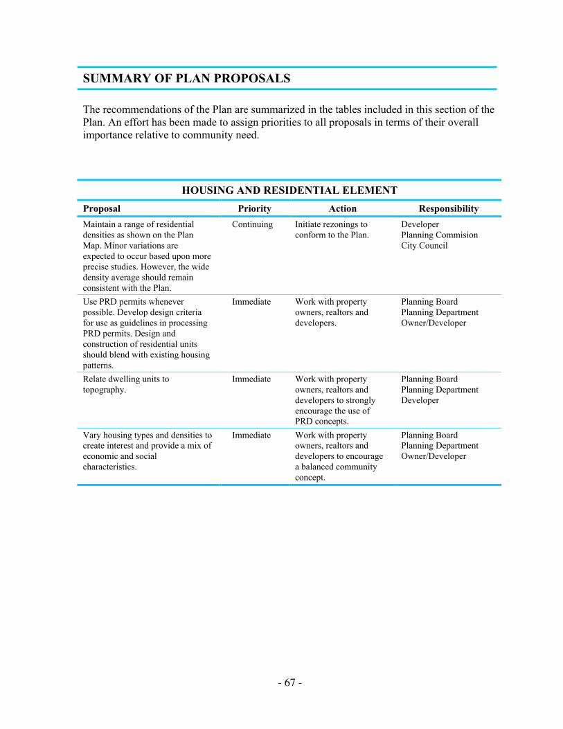
- 67 -
SUMMARY OF PLAN PROPOSALS
The recommendations of the Plan are summarized in the tables included in this section of thePlan. An effort has been made to assign priorities to all proposals in terms of their overallimportance relative to community need.
HOUSING AND RESIDENTIAL ELEMENT
Proposal Priority Action Responsibility
Maintain a range of residentialdensities as shown on the PlanMap. Minor variations areexpected to occur based upon moreprecise studies. However, the widedensity average should remainconsistent with the Plan.
Continuing Initiate rezonings toconform to the Plan.
DeveloperPlanning CommisionCity Council
Use PRD permits wheneverpossible. Develop design criteriafor use as guidelines in processingPRD permits. Design andconstruction of residential unitsshould blend with existing housingpatterns.
Immediate Work with propertyowners, realtors anddevelopers.
Planning BoardPlanning DepartmentOwner/Developer
Relate dwelling units totopography.
Immediate Work with propertyowners, realtors anddevelopers to stronglyencourage the use ofPRD concepts.
Planning BoardPlanning DepartmentDeveloper
Vary housing types and densities tocreate interest and provide a mix ofeconomic and socialcharacteristics.
Immediate Work with propertyowners, realtors anddevelopers to encouragea balanced communityconcept.
Planning BoardPlanning DepartmentOwner/Developer
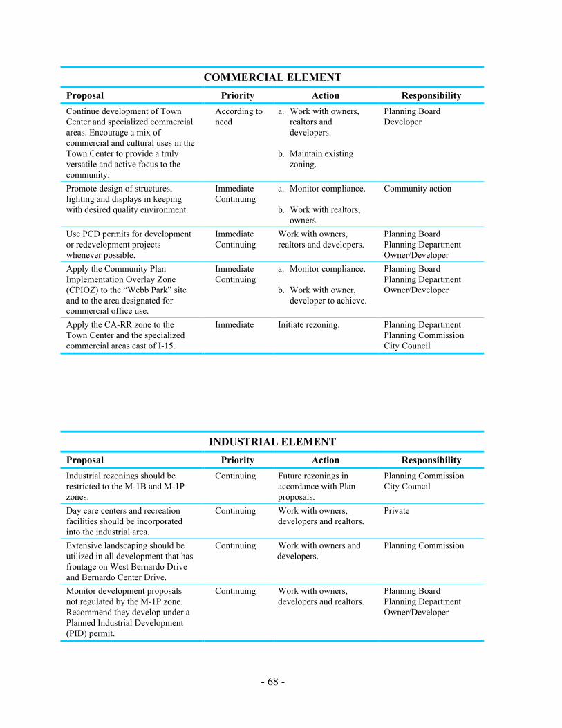
- 68 -
COMMERCIAL ELEMENT
Proposal Priority Action Responsibility
Continue development of TownCenter and specialized commercialareas. Encourage a mix ofcommercial and cultural uses in theTown Center to provide a trulyversatile and active focus to thecommunity.
According toneed
a. Work with owners,realtors anddevelopers.
b. Maintain existingzoning.
Planning BoardDeveloper
Promote design of structures,lighting and displays in keepingwith desired quality environment.
ImmediateContinuing
a. Monitor compliance.
b. Work with realtors,owners.
Community action
Use PCD permits for developmentor redevelopment projectswhenever possible.
ImmediateContinuing
Work with owners,realtors and developers.
Planning BoardPlanning DepartmentOwner/Developer
Apply the Community PlanImplementation Overlay Zone(CPIOZ) to the “Webb Park” siteand to the area designated forcommercial office use.
ImmediateContinuing
a. Monitor compliance.
b. Work with owner,developer to achieve.
Planning BoardPlanning DepartmentOwner/Developer
Apply the CA-RR zone to theTown Center and the specializedcommercial areas east of I-15.
Immediate Initiate rezoning. Planning DepartmentPlanning CommissionCity Council
INDUSTRIAL ELEMENT
Proposal Priority Action Responsibility
Industrial rezonings should berestricted to the M-1B and M-1Pzones.
Continuing Future rezonings inaccordance with Planproposals.
Planning CommissionCity Council
Day care centers and recreationfacilities should be incorporatedinto the industrial area.
Continuing Work with owners,developers and realtors.
Private
Extensive landscaping should beutilized in all development that hasfrontage on West Bernardo Driveand Bernardo Center Drive.
Continuing Work with owners anddevelopers.
Planning Commission
Monitor development proposalsnot regulated by the M-1P zone.Recommend they develop under aPlanned Industrial Development(PID) permit.
Continuing Work with owners,developers and realtors.
Planning BoardPlanning DepartmentOwner/Developer

- 69 -
COMMUNITY FACILITIES ELEMENT
Proposal Priority Action Responsibility
Police: Monitor adequacy of serviceprovided by the northern substation inRancho Peñasquitos.
Continuing Notify appropriate Cityrepresentative of service needsand follow up as needed.
Community actionPlanning BoardCity Manager
Fire: Monitor adequacy of service providedby station located in community. Apply theInstitutional Overlay Zone.
ContinuingImmediate
Notify appropriate Cityrepresentative of service needsand follow up as needed withstaff and/or Council.
Community actionPlanning BoardCity ManagerPlanning Department
Schools: Locate and construct schoolfacilities.
As needed Citizens committee anddeveloper advise and workwith Poway Unified SchoolDistrict.
Poway Unified SchoolDistrictPlanning Board
Apply the Institutional Overlay Zone topublic schools.
Immediate Citizens committee and CityPlanning work with PowayUnified School District.
Planning BoardPlanning Department
Library: Apply the Institutional OverlayZone.
Immediate Follow through forimplementation.
Planning BoardPlanning Department
Water: Monitor adequacy of service. Continuing Notify appropriate City staff ofservice needs and follow up asneeded with staff and/orCouncil.
Planning BoardCity ManagerCommunity actionCitizens committee
Sewer: Monitor adequacy of service. Continuing Notify appropriate City staff ofservice needs and follow up asneeded with staff and/orCouncil.
Citizens committeeCommunity actionPlanning BoardCity Manager
Public Transportation: Continue busservice from Rancho Bernardo todowntown San Diego.
Continuingexpress
Monitor and determineongoing.
Transit Corporationneeds
Bikeways and Equestrian Trails: Developcommunity bikeway and equestrian trailssystem coordinated with regional system.
Immediate Follow through forimplementation of approvedplans.
Planning BoardCity Manager
Open Space: establish and maintain openspace system throughout the community.
Continuing Monitor development planproposals for preservation ofnatural amenities. Initiateaction to ensure perpetuity andmaintenance of open spaceareas.
DeveloperPlanning BoardPlanning DepartmentPlanning CommissionCity CouncilCitizens committee
Park and Recreation Facilities: Providerecreational facilities in developingneighborhoods as identified on the PlanMap.
Contingentupon future
Construct improvements andensure maintenance andoperation.
Developer
Provide and maintain recreational facilitiesat the community park.
As soon aspossible
Complete construction ofrecreation facilities.
Rancho BernardoRecreation CouncilPark and Rec. Dept.City Council
Cable TV: Improve service. Continuing Monitor existing service anddetermine ongoing service toprovide acceptable servicelevel.
Citizens committeeCity Manager


- 72 -
Rancho Bernardo Community Plan Map

- 73 -
TABLE 2LAND USE RECOMMENDATIONS: SUMMARY
Provided below is an acreage summary of Plan recommendations within major land usecategories of the Rancho Bernardo Community Plan.
LAND USE AREA IN ACRES PERCENT OF TOTAL
Residential 2,954 45.2
Commercial 210 3.2
Industrial 612 9.4
Institutional 39 .6
Schools 107 1.6
Recreation and Open Space 1,526 23.7
Community Park (35)
Private Recreation (614)
Open Space (508)
Open Space (Lake Hodges) (369)
Transportation/Right-of-way 1,063 16.3
Total 6,511 100.0