human environment 2.1 land use - dot.ca.gov land use.pdf · this analysis evaluates existing land...
TRANSCRIPT

Chapter 2 Affected Environment, Environmental Consequences, and Avoidance, Minimization, and/or Mitigation Measures
State Route 74 Safety Improvement Project Initial Study/Environmental Assessment 2.1-1
HUMAN ENVIRONMENT
2.1 Land Use
The Build Alternative lies entirely within unincorporated Orange County. It is located on and adjacent to State Route 74 (SR-74), within existing California Department of Transportation (Caltrans) right-of-way and within the boundaries of Ronald W. Caspers Wilderness Park (Caspers Wilderness Park) and Cleveland National Forest.
The land use study area (study area) was generally defined by the census tracts bordering the maximum disturbance limits for the Build Alternative. The following U.S. Census Bureau census tracts make up the study area: 320.23 and 320.41. Utilizing census tract boundaries allows consistency with the assessment of community impacts and growth; also, census tract data influence development trends. As shown on Figure 2.1-1, Existing Land Uses, the study area extends through five land use jurisdictions (two counties and three cities).
The discussions in this section related to land use are provided in the following three subsections:
• 2.1.1 Existing and Future Land Uses • 2.1.2 Consistency with State, Regional, and Local Plans and Programs • 2.1.3 Parks and Recreational Facilities
2.1.1 Existing and Future Land Use This analysis evaluates existing land uses that could be converted to transportation uses by the Build Alternative. The analysis is based on the most current available geographic information system (GIS) data (dated 2012) for the applicable local jurisdictions (the County of Orange [County] and the Cities of San Clemente, San Juan Capistrano, and Rancho Santa Margarita) from the Southern California Association of Governments (SCAG); therefore, the GIS data may not reflect recent changes in existing land uses.
The study area is dominated by SR-74 and is surrounded by parks and open space, including Caspers Wilderness Park and Cleveland National Forest (refer to Figure 2.1-1 and Figure 2.1-2, General Plan Land Uses). Parks and other recreational areas are discussed in further detail in Section 2.1.3.

Chapter 2 Affected Environment, Environmental Consequences, and Avoidance, Minimization, and/or Mitigation Measures
State Route 74 Safety Improvement Project Initial Study/Environmental Assessment 2.1-2
This page intentionally left blank

Oran
ge Co
unty
Rivers
ide Co
unty
Oran
ge C
ounty
San D
iego
Coun
ty
Riverside CountySan Diego County
Project Area
Ronald W. CaspersWilderness Park
ClevelandNationalForest
City ofLake
Elsinore
City ofMission
Viejo
City of SanClemente
City ofLake Forest
City of RanchoSanta Margarita
Cityof Dana
Point
City ofSan Juan
Capistrano
ÄÆ241
ÄÆ74
320.41
320.23
§̈¦5
§̈¦15
SOURCE: ESRI (2015); Caltrans (1/2018); US Census (2010); SCAG Existing Land Use (2012)I:\CDT1609\GIS\MXD\Task22_SR74_SanJuanFire_RivCo_Env\LandUse_Existing.mxd (2/1/2018)
FIGURE 2.1-1LEGENDProject AreaStudy AreaCensus Tracts
City BoundaryCounty Boundary
0 1.25 2.5MILES 12-ORA-74 PM 11.50/16.6
EA 0P0300
SR-74 Safety Improvements ProjectExisting Land Uses
Existing Land UsesSingle Family ResidentialMulti-Family ResidentialMobile Homes and Trailer ParksMixed ResidentialGeneral OfficeCommercial and ServicesFacilitiesEducationIndustrialTransportation, Communications, and UtilitiesOpen Space and RecreationAgricultureVacantUnder ConstructionUndevelopable or Protected LandUnknown

Chapter 2 Affected Environment, Environmental Consequences, and Avoidance, Minimization, and/or Mitigation Measures
State Route 74 Safety Improvement Project Initial Study/Environmental Assessment 2.1-4
This page intentionally left blank

Oran
ge Co
unty
Rivers
ide Co
unty
Oran
ge C
ounty
San D
iego
Coun
ty
Riverside CountySan Diego County
Project Area
City ofLake
Elsinore
City ofMission
Viejo
City of SanClemente
City ofLake Forest
City of RanchoSanta Margarita
Cityof Dana
Point
City ofSan Juan
Capistrano
ÄÆ241
ÄÆ74
320.41
320.23
§̈¦5
§̈¦15
SOURCE: ESRI (2015); Caltrans (1/2018); US Census (2010); SCAG General Plan Land Use (2012)I:\CDT1609\GIS\MXD\Task22_SR74_SanJuanFire_RivCo_Env\LandUse_GeneralPlan.mxd (2/1/2018)
FIGURE 2.1-2LEGENDProject AreaStudy AreaCensus Tracts
City BoundaryCounty Boundary
0 1.25 2.5MILES 12-ORA-74 PM 11.50/16.6
EA 0P0300
SR-74 Safety Improvements ProjectGeneral Plan Land Uses
General Plan Land UsesSingle Family ResidentialMulti-Family ResidentialMobile Homes and Trailer ParksMixed ResidentialCommercial and ServicesFacilitiesIndustrialTransportation, Communications, and UtilitiesMixed Residential and CommercialOpen Space and RecreationUndevelopable or Protected Land

Chapter 2 Affected Environment, Environmental Consequences, and Avoidance, Minimization, and/or Mitigation Measures
State Route 74 Safety Improvement Project Initial Study/Environmental Assessment 2.1-6
This page intentionally left blank

Chapter 2 Affected Environment, Environmental Consequences, and Avoidance, Minimization, and/or Mitigation Measures
State Route 74 Safety Improvement Project Initial Study/Environmental Assessment 2.1-7
2.1.1.1 Existing Land Uses The majority of the existing land uses in the study area are parks and open spaces. Existing land uses within the portions of San Clemente and San Juan Capistrano within the study area include residential and commercial areas. Existing land uses in the northwest part of the study area also include residential and facilities uses adjacent to the Cities of Lake Forest and Rancho Santa Margarita.
2.1.1.2 General Plan Land Uses The majority of the planned uses in the study area are open space and recreation and undevelopable or protected land, as shown in Figure 2.1-2. Single- and multifamily residential and commercial general plan land uses are located within portions of San Clemente and San Juan Capistrano within the study area. General plan land uses in the northwest portion of this study area also include mobile home, trailer park, and single-family residential uses adjacent to the Cities of Lake Forest and Rancho Santa Margarita.
2.1.1.3 Development Trends The study area primarily consists of undevelopable or protected land and open space and recreation uses. Development within this study area primarily occurs within the urban areas in the southwestern portion of the study area adjacent to the Cities of San Juan Capistrano and San Clemente and the northwestern portion of the study area adjacent to the Cities of Lake Forest and Rancho Santa Margarita. According to the general plan uses, planned development includes a mix of residential, commercial, transportation, mobile home and trailer parks, and industrial uses. Because much of the land in the study area is parkland and national forest, development is limited surrounding the Build Alternative.
Approved and planned projects in this study area are described further in Section 2.17, Cumulative Impacts, in Table 2.17.1 and shown on Figure 2.17-1.
2.1.2 Consistency with State, Regional, and Local Plans and Programs
This section discusses the proposed project’s consistency with SCAG’s 2016–2040 Regional Transportation Plan/Sustainable Communities Strategy (RTP/SCS), SCAG’s 2017 Federal Transportation Improvement Program (2017 FTIP), and Orange County Transportation Authority’s (OCTA) Long Range Transportation Plan (LRTP). Additionally, this section discusses the proposed project’s consistency with adopted goals, policies, and plans from the County of Orange General Plan.

Chapter 2 Affected Environment, Environmental Consequences, and Avoidance, Minimization, and/or Mitigation Measures
State Route 74 Safety Improvement Project Initial Study/Environmental Assessment 2.1-8
2.1.2.1 SCAG Regional Transportation Plan/Sustainable Communities Strategy
SCAG is the Metropolitan Planning Organization (MPO) for the counties of Orange, Los Angeles, San Bernardino, Riverside, Ventura, and Imperial (SCAG region). SCAG is mandated by the federal government to develop regional plans for transportation, growth management, hazardous waste management, and air quality.
SCAG’s 2016 RTP/SCS is a long-range plan that identifies multimodal regional transportation needs and investments over the next 23 years in the SCAG region. The 2016–2040 RTP/SCS was adopted by SCAG in April 2016, and found to conform by the Federal Highway Administration/Federal Transit Administration (FHWA/FTA) in June 2016. SCAG’s 2016–2040 RTP/SCS establishes a transportation vision for the SCAG region. The 2016–2040 RTP/SCS emphasizes sustainability and integrated planning. SCAG updates the RTP every 4 years. Federal regulations require that RTP project costs be constrained to the existing revenues and new revenues that may be reasonably expected to be available over the life of the Plan. Projects on this list become eligible for federal transportation funds. This project is included in the SCAG 2016 RTP/SCS under RTP ID S2120031 and the 2017 FTIP.
2.1.2.2 SCAG Federal Transportation Improvement Program The FTIP is a capital listing of all transportation projects proposed over a 6-year period for the SCAG region. It is prepared to implement projects and programs listed in the RTP, and is developed in compliance with State and federal requirements. A new FTIP is prepared and approved every 2 years. These funded projects include highway improvements; transit, rail, and bus facilities; carpool lanes; signal synchronization; intersection improvements; freeway ramps; and other related improvements. The 2017 FTIP received its conformity determination from the FHWA/FTA on December 16, 2016.
The 2017 Federal Statewide Transportation Improvement Program (FSTIP) was adopted by FTA/FHWA in 2017. MPOs approve FTIPs for incorporation in the FSTIP and amendments to the adopted FTIP are prepared and approved on a continual basis. The project is included in the 2017 FSTIP under Project ID P074060 and is proposed for funding from the 2016 State Highway Operation and Protection Program (SHOPP) under the Safety Improvement Program.

Chapter 2 Affected Environment, Environmental Consequences, and Avoidance, Minimization, and/or Mitigation Measures
State Route 74 Safety Improvement Project Initial Study/Environmental Assessment 2.1-9
2.1.2.3 OCTA Long Range Transportation Plan The LRTP established by the OCTA outlines a vision for multimodal transportation improvements throughout the County. These projects, programs, and improvements are designed to address the transportation needs of County residents, commuters, and visitors over the next 25 years. OCTA prepares the LRTP every 4 years to account for new planning efforts, as well as the changes in demographics, economic conditions, and available sources of transportation funding, and submits the LRTP to SCAG for inclusion into the current RTP/SCS. Operational improvements, which include safety improvements to SR-74 between San Juan Capistrano and Riverside County, are included in the 2014 OCTA LRTP.
2.1.2.4 County of Orange General Plan The County of Orange General Plan (adopted in 2005 with amendments in 2012 and 2015) provides direction for land use decisions in unincorporated parts of the County. The study area includes areas of unincorporated land in Orange County along the SR-74 corridor and near the Orange/Riverside County boundary. This area is designated in the County of Orange General Plan primarily as Open Space and Recreation.
Goals and objectives from the County of Orange General Plan relevant to the proposed project are provided below.
Land Use Element Objective and Policy 5. To plan an integrated land use and transportation system that accommodates travel demand for all modes of transit.
Objective and Policy 1. Balanced Land Use: To plan urban land uses with a balance of well-connected residential, industrial, commercial, and public land uses.
Recreation Element Objective 2.1. To establish an integrated regional recreation network that meets the diverse regional recreation interests of the citizens of Orange County.
Chapter 2 Affected Environment, Environmental Consequences, and Avoidance, Minimization, and/or Mitigation Measures
State Route 74 Safety Improvement Project Initial Study/Environmental Assessment 2.1-10
2.1.2.5 Environmental Consequences Temporary Impacts Existing Land Uses
Build Alternative The Build Alternative is a safety improvement project and would not propose a capacity enhancement to SR-74; therefore, the Build Alternative would not have an effect on development trends or growth in the study area.
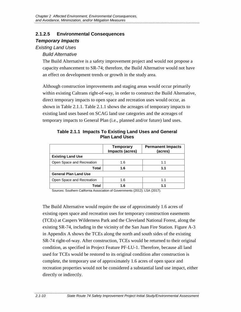
Although construction improvements and staging areas would occur primarily within existing Caltrans right-of-way, in order to construct the Build Alternative, direct temporary impacts to open space and recreation uses would occur, as shown in Table 2.1.1. Table 2.1.1 shows the acreages of temporary impacts to existing land uses based on SCAG land use categories and the acreages of temporary impacts to General Plan (i.e., planned and/or future) land uses.
Table 2.1.1 Impacts To Existing Land Uses and General Plan Land Uses
Temporary Impacts (acres)
Permanent Impacts (acres)
Existing Land Use Open Space and Recreation 1.6 1.1
Total 1.6 1.1 General Plan Land Use Open Space and Recreation 1.6 1.1
Total 1.6 1.1 Sources: Southern California Association of Governments (2012); LSA (2017).
The Build Alternative would require the use of approximately 1.6 acres of existing open space and recreation uses for temporary construction easements (TCEs) at Caspers Wilderness Park and the Cleveland National Forest, along the existing SR-74, including in the vicinity of the San Juan Fire Station. Figure A-3 in Appendix A shows the TCEs along the north and south sides of the existing SR-74 right-of-way. After construction, TCEs would be returned to their original condition, as specified in Project Feature PF-LU-1. Therefore, because all land used for TCEs would be restored to its original condition after construction is complete, the temporary use of approximately 1.6 acres of open space and recreation properties would not be considered a substantial land use impact, either directly or indirectly.
Chapter 2 Affected Environment, Environmental Consequences, and Avoidance, Minimization, and/or Mitigation Measures
State Route 74 Safety Improvement Project Initial Study/Environmental Assessment 2.1-11
PF-LU-1 Restoration of Land Used Temporarily. Before the onset of construction use, the construction contractor shall generate time-stamped photo documentation of the pre-construction conditions of all temporary staging areas. All construction access, mobilization, material laydown, and staging areas would be returned to a condition equal to the pre-construction staging condition.
No Build Alternative The No Build Alternative does not include the construction of transportation improvements in the project area. As a result, the No Build Alternative would not result in direct or indirect impacts to temporary land uses or long-term effects related to General Plan land uses.
Consistency with State, Regional, and Local Plans and Programs Build Alternative The Build Alternative is a highway safety improvement project that would be constructed mostly within Caltrans right-of-way and within SR-74’s same general alignment, consistent with Caltrans standards and policies. Temporary construction activities would not result in any conflicts with relevant State, regional, and local plans. Land use consistency impacts related to right-of-way acquisition are permanent and are discussed below.
No Build Alternative The No Build Alternative would maintain the current configurations of SR-74 in the study area. Under the No Build Alternative, the SR-74 safety improvements would not be constructed. Therefore, the No Build Alternative would not result in any temporary impacts to land use consistency.
Permanent Impacts Existing Land Uses
Build Alternative The Build Alternative would be constructed mostly within existing Caltrans right-of-way. However, the Build Alternative would require the permanent acquisition of approximately 1.1 acres of land on existing open space and recreation properties (refer to Table 2.1.1 for permanent impacts to existing and General Plan land uses). However, updates to the General Plan would not be required due to the limited linear acquisition associated with the Build Alternative. The Build

Chapter 2 Affected Environment, Environmental Consequences, and Avoidance, Minimization, and/or Mitigation Measures
State Route 74 Safety Improvement Project Initial Study/Environmental Assessment 2.1-12
Alternative would result in the acquisition of approximately 0.21 acre within the approximately 460,000-acre Cleveland National Forest and approximately 0.72 acre within the approximately 8,000-acre Caspers Wilderness Park. The proposed amount of land to be acquired for easement purposes is approximately 0.00005 percent of the total amount of land in the Cleveland National Forest and is less than 0.1 percent of the total amount of land in Caspers Wilderness Park. Therefore, permanent impacts to open space and recreation land uses would be minimal compared to the overall size of Cleveland National Forest and Caspers Wilderness Park. Furthermore, because the affected parcels are at the edge of open space and recreation lands, adjacent to Caltrans right-of-way, the permanent acquisition would not affect the rest of the existing open space or recreational uses.
No Build Alternative The No Build Alternative does not include the construction of transportation improvements in the project area. As a result, the No Build Alternative would not result in direct or indirect impacts to existing land uses or long-term effects related to General Plan land uses, including permanent easements and right-of-way acquisition.
Consistency with State, Regional, and Local Plans and Programs Build Alternative The Build Alternative is consistent with regional transportation planning efforts. The proposed project is identified and included in the 2016 RTP/SCS, is programmed in the 2017 FTIP, and is included in the 2014 OCTA LRTP.
1 The impacts to acreages in Cleveland National Forest come from 2017 United
States Forest Service (USFS) boundary data. The USFS boundaries differ from the 2012 SCAG land use data, and as a result, the total impacts to open space and recreation uses are not equal to the sum of impacts to Cleveland National Forest and Caspers Wilderness Park.
2 The impacts to acreages in Caspers Wilderness Park come from 2012 Orange County Parks (OC Parks) boundary data. The OC Parks boundaries differ from the 2012 SCAG land use data, and as a result, the total impacts to open space and recreation uses are not equal to the sum of impacts to Cleveland National Forest and Caspers Wilderness Park.
Chapter 2 Affected Environment, Environmental Consequences, and Avoidance, Minimization, and/or Mitigation Measures
State Route 74 Safety Improvement Project Initial Study/Environmental Assessment 2.1-13
The Build Alternative would result in the permanent acquisition of land in the park and recreational facility, Caspers Wilderness Park. The acquisition would total approximately 0.7 acre of the approximately 8,000-acre park. This small acquisition along the existing SR-74 right-of-way would not conflict with the County’s ability to establish an integrated regional recreation network that meets the region’s recreation needs. Therefore, the Build Alternative is consistent with the Recreation Element of the County of Orange General Plan.
The Build Alternative would result in safety improvements to this segment of SR-74. Improved roadway safety would improve the County’s ability to safely connect residential, industrial, commercial, and public land uses. Improved safety on SR-74 would facilitate the County’s ability to create an integrated land use and transportation system that accommodates travel demand. Therefore, the Build Alternative is consistent with the Land Use Element of the County of Orange General Plan.
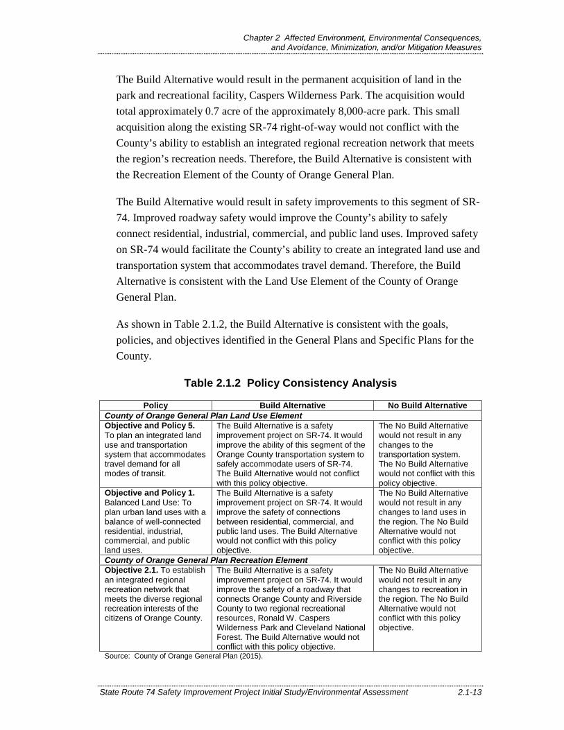
As shown in Table 2.1.2, the Build Alternative is consistent with the goals, policies, and objectives identified in the General Plans and Specific Plans for the County.
Table 2.1.2 Policy Consistency Analysis
Policy Build Alternative No Build Alternative County of Orange General Plan Land Use Element Objective and Policy 5. To plan an integrated land use and transportation system that accommodates travel demand for all modes of transit.
The Build Alternative is a safety improvement project on SR-74. It would improve the ability of this segment of the Orange County transportation system to safely accommodate users of SR-74. The Build Alternative would not conflict with this policy objective.
The No Build Alternative would not result in any changes to the transportation system. The No Build Alternative would not conflict with this policy objective.
Objective and Policy 1. Balanced Land Use: To plan urban land uses with a balance of well-connected residential, industrial, commercial, and public land uses.
The Build Alternative is a safety improvement project on SR-74. It would improve the safety of connections between residential, commercial, and public land uses. The Build Alternative would not conflict with this policy objective.
The No Build Alternative would not result in any changes to land uses in the region. The No Build Alternative would not conflict with this policy objective.
County of Orange General Plan Recreation Element Objective 2.1. To establish an integrated regional recreation network that meets the diverse regional recreation interests of the citizens of Orange County.
The Build Alternative is a safety improvement project on SR-74. It would improve the safety of a roadway that connects Orange County and Riverside County to two regional recreational resources, Ronald W. Caspers Wilderness Park and Cleveland National Forest. The Build Alternative would not conflict with this policy objective.
The No Build Alternative would not result in any changes to recreation in the region. The No Build Alternative would not conflict with this policy objective.
Source: County of Orange General Plan (2015).

Chapter 2 Affected Environment, Environmental Consequences, and Avoidance, Minimization, and/or Mitigation Measures
State Route 74 Safety Improvement Project Initial Study/Environmental Assessment 2.1-14
No Build Alternative The No Build Alternative would maintain the current configurations of SR-74 in the study area. Under the No Build Alternative, the SR-74 safety improvements would not be constructed. Therefore, the No Build Alternative would not result in any permanent impacts to land use consistency.
2.1.2.6 Avoidance, Minimization, and/or Mitigation Measures With incorporation of Project Features PF-LU-1 and PF-LU-2, described above, no avoidance, minimization, and/or mitigation measures would be necessary.
2.1.3 Parks and Recreational Facilities 2.1.3.1 Regulatory Setting This project will affect facilities that are protected by the Park Preservation Act (California Public Resources Code [PRC] Sections 5400-5409). The Park Preservation Act prohibits local and state agencies from acquiring any property which is in use as a public park at the time of acquisition unless the acquiring agency pays sufficient compensation or land, or both, to enable the operator of the park to replace the park land and any park facilities on that land.
2.1.3.2 Affected Environment This section discusses parks and recreation facilities. Parks and recreational facilities within the study area include Caspers Wilderness Park, along with several trails that are open to hikers, equestrians, and mountain bicyclists, and the Cleveland National Forest.
Caspers Wilderness Park is a multi-use park and wilderness preserve, and the largest park in the OC Parks system. It encompasses over 8,000 acres in the western coastal Santa Ana Mountains. The park provides a multitude of outdoor experiences for visitors. Available facilities and activities include multi-use trails and camping and day use sites, ranger-guided nature walks, and naturalist lectures. Caspers Wilderness Park is both a park and a protected wilderness preserve. Parks are currently defined as meeting the requirements for protection under Section 4(f). In addition, Caspers Wilderness Park is within the Orange County Southern Sub-Region Natural Community Conservation Plan/ Master Streambed Alteration Agreement/Habitat Conservation Plan (NCCP/MSAA/HCP) habitat preserve area. The HCP established a permanent habitat reserve and land management program for approximately 132,000 acres and created a preservation area totaling 32,818 acres for the protection of wildlife and vegetation communities.

Chapter 2 Affected Environment, Environmental Consequences, and Avoidance, Minimization, and/or Mitigation Measures
State Route 74 Safety Improvement Project Initial Study/Environmental Assessment 2.1-15
The Cleveland National Forest is the smallest designated National Forest and the southernmost National Forest in California, encompassing over 460,000 acres. The Cleveland National Forest contains the Santa Ana, Palomar, and Laguna (Cuyamaca) Mountains and four wilderness areas: (1) Agua Tibia Wilderness, (2) Pine Creek Wilderness, (3) Hauser Wilderness, and (4) San Mateo Canyon Wilderness. The wilderness areas are part of the National Wilderness System1 and are managed differently than the rest of the National Forest. Wilderness areas are recognized as wild areas that provide essential habitat for various plant and wildlife species. The Cleveland National Forest contains trails for bicycling, hiking, horse riding, nature viewing, and off-highway-vehicle riding. In addition, it has facilities for fishing, camping, horse camping, and day use picnicking. As a National Forest, the Cleveland National Forest, as a whole, is not a protected resource under Section 4(f). However, the Cleveland National Forest does contain land use zones that have been deemed as suitable for recreational uses (specifically the Developed Areas Interface and Back Country Zones identified in the Land Management Plan, Part 2 – Cleveland National Forest Strategy) directly adjacent to the SR-74 right-of-way. Therefore, Caltrans has deemed the Cleveland National Forest land as a recreational facility, meeting the requirements for protection under Section 4(f).
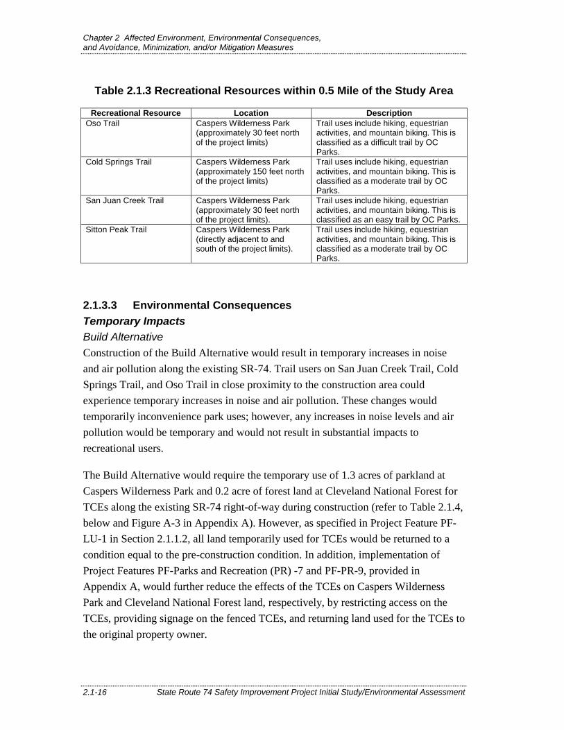
Recreational facilities located in both Caspers Wilderness Park and Cleveland National Forest are shown in Figure A-2, Project Location, in Appendix A. Within 0.5 mile of the Build Alternative, four recreational facilities are located north of SR-74 and one is located south of SR-74. There are three multi-use trails in Caspers Wilderness Park north of SR-74 (Oso Trail, Cold Springs Trail, and San Juan Creek Trail) and one multi-use trail south of SR-74 (Sitton Peak Trail). These recreational facilities located within 0.5 mile of the project limits along SR-74 are described in Table 2.1.3.
1 The Wilderness Act of 1964 established the National Wilderness Preservation
System, which includes 149 wilderness areas in California.
Chapter 2 Affected Environment, Environmental Consequences, and Avoidance, Minimization, and/or Mitigation Measures
State Route 74 Safety Improvement Project Initial Study/Environmental Assessment 2.1-16
Table 2.1.3 Recreational Resources within 0.5 Mile of the Study Area
Recreational Resource Location Description Oso Trail Caspers Wilderness Park
(approximately 30 feet north of the project limits)
Trail uses include hiking, equestrian activities, and mountain biking. This is classified as a difficult trail by OC Parks.
Cold Springs Trail Caspers Wilderness Park (approximately 150 feet north of the project limits)
Trail uses include hiking, equestrian activities, and mountain biking. This is classified as a moderate trail by OC Parks.
San Juan Creek Trail Caspers Wilderness Park (approximately 30 feet north of the project limits).
Trail uses include hiking, equestrian activities, and mountain biking. This is classified as an easy trail by OC Parks.
Sitton Peak Trail Caspers Wilderness Park (directly adjacent to and south of the project limits).
Trail uses include hiking, equestrian activities, and mountain biking. This is classified as a moderate trail by OC Parks.
2.1.3.3 Environmental Consequences Temporary Impacts Build Alternative Construction of the Build Alternative would result in temporary increases in noise and air pollution along the existing SR-74. Trail users on San Juan Creek Trail, Cold Springs Trail, and Oso Trail in close proximity to the construction area could experience temporary increases in noise and air pollution. These changes would temporarily inconvenience park uses; however, any increases in noise levels and air pollution would be temporary and would not result in substantial impacts to recreational users.
The Build Alternative would require the temporary use of 1.3 acres of parkland at Caspers Wilderness Park and 0.2 acre of forest land at Cleveland National Forest for TCEs along the existing SR-74 right-of-way during construction (refer to Table 2.1.4, below and Figure A-3 in Appendix A). However, as specified in Project Feature PF-LU-1 in Section 2.1.1.2, all land temporarily used for TCEs would be returned to a condition equal to the pre-construction condition. In addition, implementation of Project Features PF-Parks and Recreation (PR) -7 and PF-PR-9, provided in Appendix A, would further reduce the effects of the TCEs on Caspers Wilderness Park and Cleveland National Forest land, respectively, by restricting access on the TCEs, providing signage on the fenced TCEs, and returning land used for the TCEs to the original property owner.

Chapter 2 Affected Environment, Environmental Consequences, and Avoidance, Minimization, and/or Mitigation Measures
State Route 74 Safety Improvement Project Initial Study/Environmental Assessment 2.1-17
Table 2.1.4 Impacts to Ronald W. Caspers Wilderness Park and Cleveland National Forest
Resource Permanent Impacts Temporary Impacts Cleveland National Forest 0.2 0.2 Ronald W. Caspers Wilderness Park 0.7 1.3
Total (acres) 0.9 1.51 Sources: County of Orange (2012) and United States Forest Service (2017). 1 The total acreage varies due to rounding errors.
Project construction would require a TCE along an approximately 60-foot segment of the San Juan Creek Trail within Caspers Wilderness Park in order to replace an existing culvert under this section of the trail. Although work at this location would occur underneath the trail, contained to the culvert below, during construction the trail would be temporarily closed from Cold Springs Trail to Oso Trail, and would be temporarily detoured. The detour would go around the TCE on San Juan Creek Trail via Oso Trail and Cold Springs Trail and would be approximately 2.5 miles in length (an increase of 1.75 miles over the closed trail segment), as illustrated on Figure A-4, Temporary Trail Closure and Detours, provided in Appendix A. This detour would be available for both northbound and southbound trail users; however, access to Cold Springs Trail from San Juan Creek Trail to the south would also be temporarily interrupted. Cold Springs Trail would still be accessible during the detour, but trail users approaching from the southwest via San Juan Creek Trail would have to access the trail from Oso Trail. The Oso Trail and the Cold Springs Trail are classified as difficult and moderate trails, respectively, whereas San Juan Creek Trail is classified as an easy trail. Therefore, adequate signage notifying trail users of the increased difficulty and length of the detour route will be necessary. The trail would only be closed intermittently over a period of one to two days.
As specified in Appendix A, Project Features PF-PR-1 through PF-PR-5 would address short-term impacts to the San Juan Creek Trail during construction by requiring the preparation of a Temporary Trail Closure Plan, the coordination of trail closures and detours with local jurisdictions, the identification of alternative trail routes and project contact information, and the restoration of the trail upon completion of construction. Therefore, compliance with Project Features PF-LU-1, PF-PR-1 through PF-PR-5, PF-PR-7, and PF-PR-9 would reduce any temporary impacts to parks and recreational facilities during construction.
Chapter 2 Affected Environment, Environmental Consequences, and Avoidance, Minimization, and/or Mitigation Measures
State Route 74 Safety Improvement Project Initial Study/Environmental Assessment 2.1-18
No Build Alternative
The No Build Alternative would maintain the existing configurations of SR-74 in the study area. Under the No Build Alternative, the SR-74 safety improvements would not be constructed, and no temporary impacts to park and recreational uses would occur.
Permanent Impacts
Build Alternative
Implementation of the Build Alternative would require the acquisition of 0.2 acre of land at Cleveland National Forest and 0.7 acre of land at the edge of Caspers Wilderness Park for additional right-of-way along the existing SR-74. The proposed amount of land to be acquired is approximately 0.00005 percent of the total amount of land in Cleveland National Forest and is less than 0.1 percent of the total amount of land in Caspers Wilderness Park. Therefore, permanent impacts would be minimal compared to the overall size of Cleveland National Forest and Caspers Wilderness Park. In addition, the land in question would be utilized for an easement to allow for the construction and continued operation of SR-74, and the land being acquired is not useful in terms of the overall recreational management of either the Cleveland National Forest or Caspers Wilderness Park and would not degrade the activities, features, or attributes of the land. Caltrans requires a federal land transfer on all federal-aid projects on public lands, after the granting federal agency (i.e., Cleveland National Forest) issued a Letter of Consent that would appropriate a certain parcel of land for highway purposes. Additionally, Caltrans would provide compensation for any permanent acquisitions of property from publicly owned parks subject to Section 4(f), as specified in Project Feature PF-LU-2. Furthermore, no permanent alteration to any existing trails or recreational facilities would be required for the acquisition of land along SR-74. Project Features PF-PR-6 and PF-PR-8, provided in Appendix A, would ensure that all permanent acquisitions would comply with the Uniform Relocation Assistance and Real Property Acquisition Policies Act of 1970 (Uniform Act). Adherence to project features would reduce permanent effects to parks and recreational resources.
PF-LU-2 Compensation for Publicly Owned Parks Under the California Park Preservation Act. Per Public Resources Code Division 5, Chapter 2.5, Section 5401 of the California Park Preservation Act, the California Department of Transportation (Caltrans) would provide compensation or land, or both, for all permanent acquisitions of

Chapter 2 Affected Environment, Environmental Consequences, and Avoidance, Minimization, and/or Mitigation Measures
State Route 74 Safety Improvement Project Initial Study/Environmental Assessment 2.1-19
property from publicly owned parks, consistent with the requirements of the California Park Preservation Act of 1971. The California Park Preservation Act requires that the compensation or land, or both, for the taking of the park land and facilities be equal to one of the following:
• The cost of acquiring substitute park land of comparable characteristics, substantially equal size, and condition; or
• Substitute park land of comparable characteristics, substantially equal size, and condition; or
• Any combination of substitute parkland and compensation in an amount sufficient to provide substitute parkland of comparable characteristics, substantially equal size, and condition.
During the right-of-way acquisition process, Caltrans would consult with the public agency with jurisdiction over any publicly owned park from which Caltrans requires permanent acquisition of property regarding the specific conditions of acquisition and compensation for, or replacement or enhancement of, other park property for the land that would be acquired.
No Build Alternative The No Build Alternative would maintain the existing configurations of SR-74 in the study area. Under the No Build Alternative, the SR-74 safety improvements would not be constructed, and no permanent impacts to park and recreational uses would occur.
2.1.3.4 Avoidance, Minimization, and/or Mitigation Measures With incorporation of Project Features PF-LU-1 and PF-LU-2 and PF-PR-1 through PF-PR-9, no avoidance, minimization, and/or mitigation measures would be necessary.
2.1.3.5 Section 4(f) Evaluation and Preliminary De Minimis Determination
Section 6009(a) of the Safe, Accountable, Flexible, Efficient Transportation Equity Act: A Legacy for Users (SAFETEA-LU) amended Section 4(f) legislation at 23 United States Code (USC) 138 and 49 USC 303 to simplify the processing and approval of projects that have only de minimis impacts on land protected by Section 4(f). This revision provides that once the United State Department of Transportation

Chapter 2 Affected Environment, Environmental Consequences, and Avoidance, Minimization, and/or Mitigation Measures
State Route 74 Safety Improvement Project Initial Study/Environmental Assessment 2.1-20
(USDOT) determines that a transportation use of Section 4(f) property, after consideration of any impact avoidance, minimization, and mitigation or enhancement measures, results in a de minimis impact on that property, an analysis of avoidance alternatives is not required and the Section 4(f) evaluation process is complete. FHWA’s final rule on Section 4(f) de minimis findings is codified in 23 Code of Federal Regulations (CFR) 774.3 and CFR 774.17. Responsibility for compliance with Section 4(f) has been assigned to Caltrans pursuant to 23 USC 326 and 327, including determinations and approval of Section 4(f) evaluations, as well as coordination with those agencies that have jurisdiction over a Section 4(f) resource that may be affected by a project action. De minimis impacts on publicly owned parks, recreation areas, and wildlife and waterfowl refuges are defined as those that do not substantially affect the activities, features, and attributes of the Section 4(f) resource. Caltrans must make a finding for each resource, and the responsible official with jurisdiction over each resource must agree in writing with that finding.
As discussed above, Caspers Wilderness Park and the Cleveland National Forest were determined to trigger the requirements for protection under Section 4(f) (refer to Table A.1 in Appendix A). The permanent easements in Caspers Wilderness Park (including the San Juan Creek Trail and the HCP area) and Cleveland National Forest would not result in the permanent acquisition or modifications of any recreational facilities or activities in the park, including trails, picnic areas, or other amenities. In addition, the amount of land proposed for permanent easements within the park and forest is a negligible percent of the total size of the park and forest. Implementation of Project Features PF-PR-6 and PF-PR-8 would ensure that the permanent easements are minor and would not detract from the active use areas that qualify the park and forest for protection under Section 4(f). Therefore, the Build Alternative would constitute a de minimis impact to these recreational resources. Please refer to Appendix A, Draft Section 4(f) De Minimis Finding and Resources Evaluated Relative to the Requirements of Section 4(f), for the full analysis.