historical analysis: washington square park
DESCRIPTION
Since its conception in 1925, Washington Square Park has evolved along with the development of Kansas City, while retaining its permanence through the city’s various transformations. In order to gain a comprehensive understanding of Washington Square Park’s history, certain aspects of the transformations in Kansas City were studied. By analyzing these various aspects, the objective of this booklet is to provide a thorough overview of Washington Square Park’s transformation over time.TRANSCRIPT

Kans
as C
ity D
esig
n C
ente
r |
Urb
an D
esig
n St
udio
201
3-20
14H
isto
rical
Ana
lysi
sW
ashi
ngto
n Squ
are P
ark
1

2

04
conc
lusi
onm
orph
olgy
14 26Origins and Development
MorphologyProcessFigure GroundHydrologyRailsParks
Conclusion
Contents
IntroductionOriginsInfl uential Context DevelopmentKansas City and the Kessler SystemWashington Square ParkPrevious Design ProposalsConclusion
orig
ins
3

Introduction Since its conception in 1925, Washington Square Park has evolved along with the development of Kansas City, while retaining its permanence through the city’s various transformations. In order to gain a comprehensive understanding of Washington Square Park’s history, certain aspects of the transformations in Kansas City were studied. The initial research conducted consisted of studying the origins of the park and its infl uential context development, as well as considering the larger scale of Kansas City and the Kessler System. Aspects of Kansas City’s morphology were analyzed, such as the rails, hydrology, built environment, and Kessler System. By analyzing these various aspects, the objective of this booklet is to provide a thorough overview of Washington Square Park’s transformation over time.
4

orig
ins
and
deve
lopm
ent
02
5
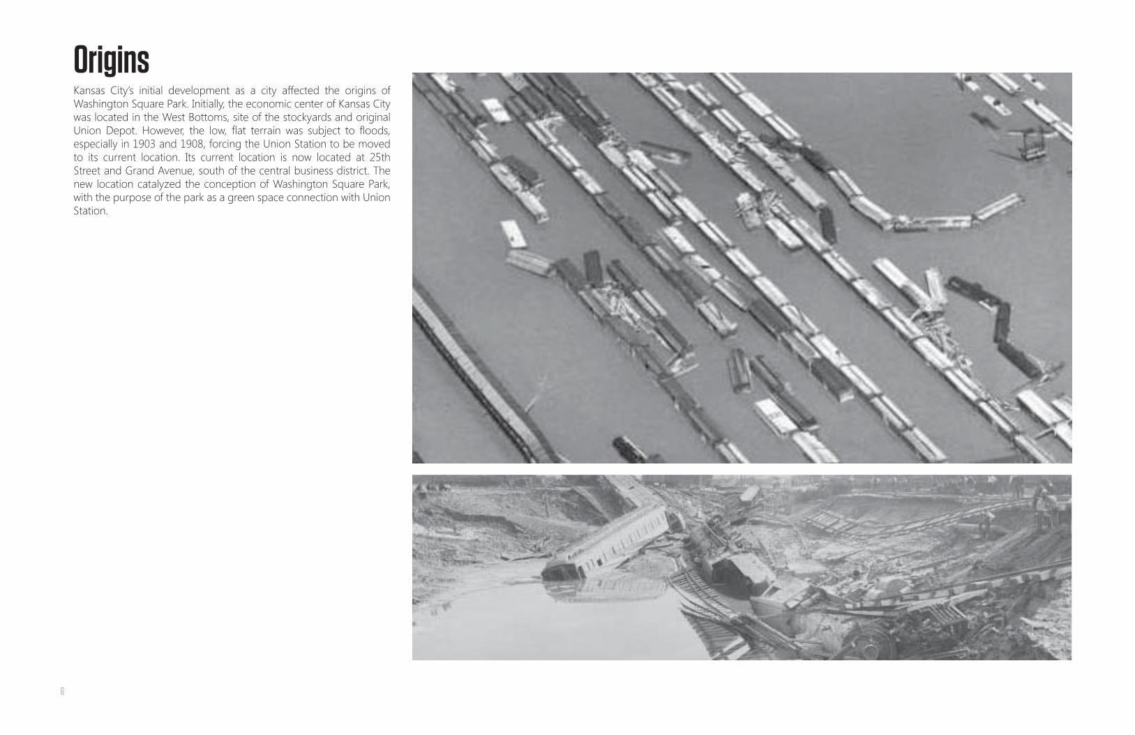
OriginsKansas City’s initial development as a city affected the origins of Washington Square Park. Initially, the economic center of Kansas City was located in the West Bottoms, site of the stockyards and original Union Depot. However, the low, fl at terrain was subject to fl oods, especially in 1903 and 1908, forcing the Union Station to be moved to its current location. Its current location is now located at 25th Street and Grand Avenue, south of the central business district. The new location catalyzed the conception of Washington Square Park, with the purpose of the park as a green space connection with Union Station.
6

Infl uential Context DevelopmentThe development of certain contextual elements infl uenced the conception and development of Washington Square Park. Notable elements include Union Station, the Liberty Memorial, and Pershing Road. Union Station and its accompanying rails cost a combined $50 million by the completion in 1914. Union Station and the traffi c it attracted infl uenced the conception of Washington Square Park and served as a connection. With the end of World War I, there was a need to commemorate those who lost their lives in the war. Designed by Kessler, the Liberty Memorial Park was also a part of the Kessler System, connected to the nearby Washington Square Park. The memorial and park were completed in 1926. Pershing Road, the adjacent street to Washington Square Park, was redesigned by Kessler to respond to Union station. It was widened to integrate green spaces (the eventual Washington Square Park). These contextual elements served as both catalysts and infl uences in the conception and ongoing existence of Washington Square Park. These elements remain infl uential to this day.
7

Kansas City & The Kessler SystemAs a unique characteristic of Kansas City, the Kessler System played an important role in the evolution of Kansas City. The City Beautiful Movement at the turn of the century, provided a system of boulevards and parkways, as well as parks to improve the overall urban environment of Kansas City. The Kessler System shaped the growth of Kansas city, defi ning clear zones of commercial, industrial, and residential with its system of parks and boulevards. As a part of the Kessler System, Washington Square Park served as a connection to not only Union Station, but as an anchor to the other parks within the Kessler System.
8

Washington Square ParkThe approximately fi ve acre park was originally designed by the landscape architecture fi rm of Hare and Hare to offer a civic space to users of the new urban area. The conception of Washington Square Park began in 1921 with a need for a distinct landmark to welcome those arriving by train and money was raised for the George Washington statue for Kansas City. Several locations of the statue were recommended, but eventually went to land that was selected and acquired by the Kansas City Parks Board in 1921 as a part of the condemnation of property for what became Pershing Road. The George Washington statue was dedicated on November 11, 1925 and the land was given the name Washington Square in 1925. It was designed and developed as a key anchor park in the Kessler System, providing a civic space connection to the people using Union Station and other surrounding context.
9

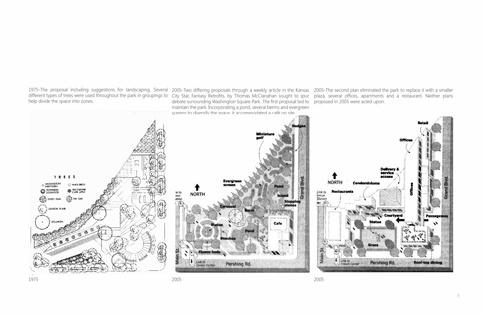
Previous Design Proposals Through its existence, Washington Square Park has been subject to various changes and design proposals. Landscaping consisting of elm and sycamore trees were added in 1938 and in 1975 a design was proposed to transform the park into a mixed use space. However, that project fell through, with concrete pavers and lampposts added in 1986 as the only major changes to the park. Other redesigns of the park have been proposed without coming to fruition. These proposals provide insight to the possibilities of Washington Square Park.
1938- Plan for Improving Washington Square Park and Pershing Road. This proposal was overseen by the Board of Park Commissioners, and conducted by W. H. Dunn. It included the addition of many elm and sycamore trees along with winding paths.
1925- The original layout of Washington Square Park. At this point there was a road dividing the park and the statue was located in the middle of the Southern section. There also a signifi cant connection to Union Station.
1925 1938 1975
1975-The parks commission proposed a major intervention in 1975 as the park was in a state of disrepair. The aim was to turn Washington Square Park into an inviting mixed-use space, incorporating brick terracing, lighting, and two large projection screens for the display of indigenous art. Little seems to have come from these intentions due to a lack of fi nancial support.
10
1975 2005 2005
1975-The proposal including suggestions for landscaping. Several different types of trees were used throughout the park in groupings to help divide the space into zones.
2005-Two differing proposals through a weekly article in the Kansas City Star, Fantasy Retrofi ts, by Thomas McClanahan sought to spur debate surrounding Washington Square Park. The fi rst proposal bid to maintain the park. Incorporating a pond, several berms and evergreen screens to diversify the space, it accommodated a café on site.
2005-The second plan eliminated the park to replace it with a smaller plaza, several offi ces, apartments and a restaurant. Neither plans proposed in 2005 were acted upon.
11

IntroductionSince Washington Square Park is deeply rooted in the history of Kansas City, it is important to analyze the physical morphology of the city and its infl uence on the park. The morphology addressed includes the built environment, hydrology, rails, and the park system. By studying these aspects, the purpose is to understand its surroundings and the larger role they played in shaping Kansas City.
Comprehensive maps were compiled for each morphological aspect to refl ect the transformation of Kansas City, and more specifi cally Washington Square Park. The fi gure ground shows not only the transformation of the overall built environment, but also how the built environment created a disconnect with Washington Square Park, changing its original purpose. The hydrology map refl ects the transformation of Turkey Creek, changing from a natural to urban environment to adapt to the rail liens. The rail lines show the change in railroads and its infl uence on the site. The morphology of the Kessler System shows the relationship between Washington Square Park and other parks as well as its role in the Kessler System.
Figure Ground Hydrology
12

mor
phol
ogy
22
RailsRails ParksParks
13

Process
19251909
In order to make analogies regarding morphology, Sanborn Maps were compiled to create aerial maps of the years 1896, 1909, 1925, 1969, 1997, and 2013. The years were chosen due to accessibility and to refl ect a broad range of Kansas City’s growth and transformation.
1896
14

1969 1997 2013
15

Figure Ground
1969 1997 2013
In order to make analogies regarding morphology, Sanborn Maps were compiled to create aerial maps of the years 1896, 1909, 1925, 1969, 1997, and 2013. The years were chosen due to accessibility and to refl ect a broad range of Kansas City’s growth and transformation.
1896 1909 1925
16

Figure Ground: 1896-2013Figure Ground: 1896-2013 Overlay of all Figure Ground MapsOverlay of all Figure Ground Maps
17
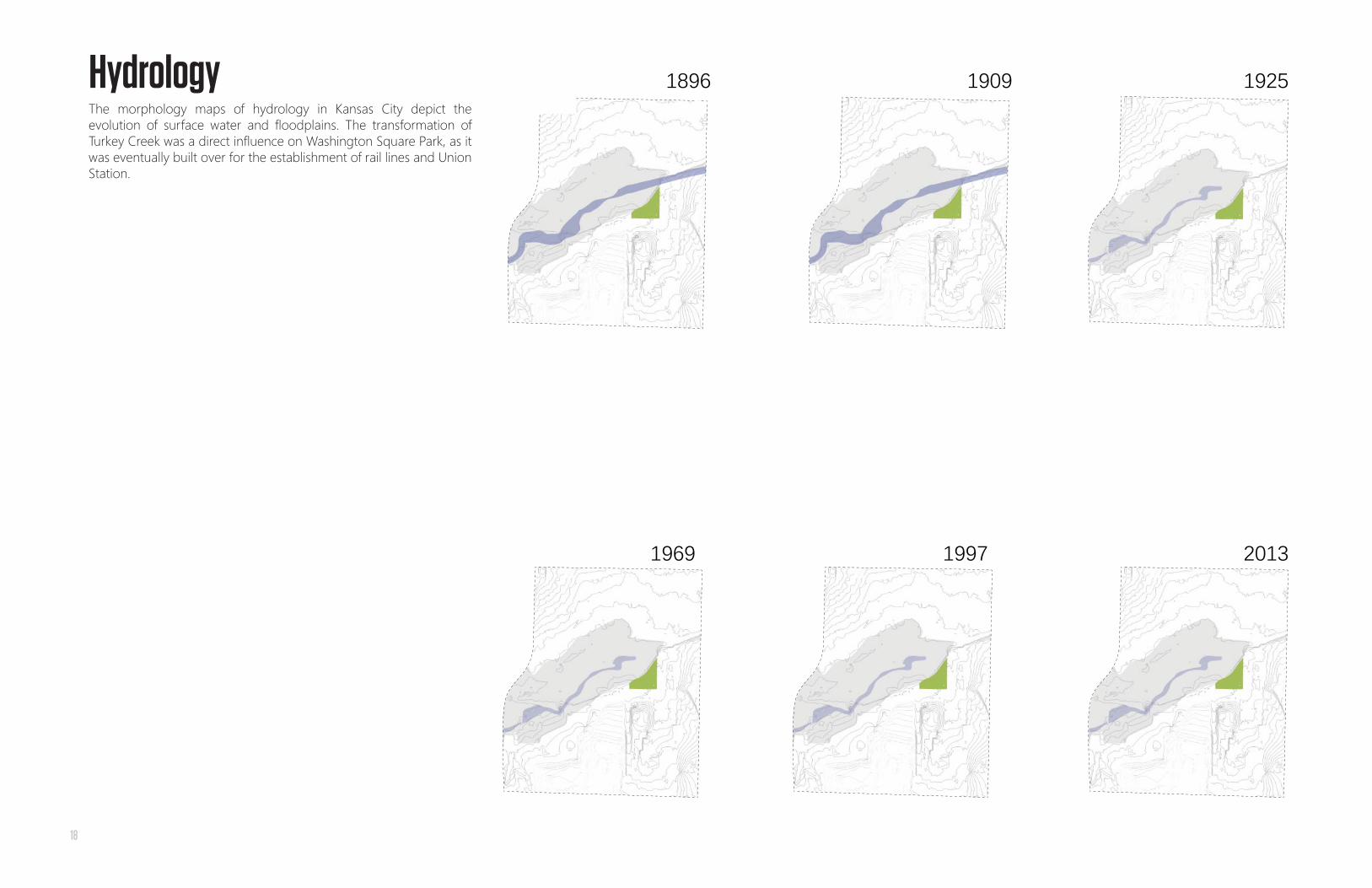
Hydrology
1969 1997 2013
The morphology maps of hydrology in Kansas City depict the evolution of surface water and fl oodplains. The transformation of Turkey Creek was a direct infl uence on Washington Square Park, as it was eventually built over for the establishment of rail lines and Union Station.
1896 1909 1925
18

Water Conditions: 1896-2013Water Conditions: 1896-2013 Overlay of all Hydrology MapsOverlay of all Hydrology Maps
19

Rails
1969 1997 2013
The railroad maps show the relationship between the rails and Washington Square Park, once having a stronger relationship, but now disconnected through a void. The shift in the hub of rails depicts the move of the main train station from the West Bottoms to its current location south of the business district. The maps also reflect both the growth and decrease in rail lines due to the automobile.
1896 1909 1925
20

Railroads: 1896-2013Railroads: 1896-2013 Overlay of all Rail MapsOverlay of all Rail Maps
21

Parks
1997 2013
It was imperative to conduct a morphology map of the Kessler System due to its influence on both Kansas City and Washington Square Park. Its difficult to ascertain real and implied connections between the parks due to the built environment and highway infrastructure. However, these maps reflect how the green spaces have evolved and tried to maintain connections despite the infrastructure obstructions.
1896 1909 1925
1969
22

Parks and Boulevards: 1896-2013Parks and Boulevards: 1896-2013 Overlay of all Kessler System MapsOverlay of all Kessler System Maps
23

ConclusionThrough conducting research and analysis of the origins and morphology of both Kansas City and Washington Square Park, the objective is to have a comprehensive understanding of the development of the park and its surrounding context.
Therefore, the development of Kansas City and the Kessler System were studied as well as the infl uential context developments to make inferences regarding its current state. Morphology of infl uential aspects such as the built environment, hydrology, railroads, and the Kessler System were studied and compiled to understand the signifi cance of the transformations and its infl uences of Kansas City and Washington Square Park.
Through these studies, it was discovered that Washington Square Park is deeply rooted in the history of Kansas City, having survived various contextual transformations. By realizing its original purpose as a connection to Union Station, it can be said that the park has been disconnected from its intent. With this disconnect from its purpose, the park now currently exists as leftover space.
24

Kansas City Design Center |Urban Design Studio 213-2014
Location 1018 Baltimore Avenue Kansas City, MO 64105Phone 816.421.5232Web http://studio.kcdesigncenter.org/
[email protected] Instructor
Vladimir Krstic
Authors
Robert ArmstrongJacob ChristillesTaryn KleinCassiday Love Contributors
Daniel AllenBrett FastCalleigh FreeseChristinaHenningMary Rogers
[email protected]@[email protected]@k-state.edu
[email protected]@[email protected]@[email protected]
conc
lusi
on25
25

26

ReferencesBoutros, Janice, David Boutros, Charlotte R. White, and Deon Wolfenbarger. A Legacy of Design: An Historical Survey of the Kansas City,
Missouri, Parks & Boulevards System, 1893-1940. Kansas City: KC Center for Design Education, 1995. Print.
“Green + Civic Spaces.” Kansas City Design Center. N.p., n.d. Web. 03 Feb. 2014. <http://kcdesigncenter.org/projects/parks-civic-spaces/>.
Landis, Margaret. The Winding Valley and the Craggy Hillside: A History of the City of Rosedale, Kansas. N.p.: n.p., 1976. Print.
McClanahan, Thomas. “Invitation to the Outdoors: Two Ways to Fill the Void of Washington Square Park.” The Kansas City Star 6 Mar. 2005: n.
pag. Print.
Missouri. Parks and Recreation Department. Board of Parks and Recreation Commissioners. Washington Square Park. By Frank Vaydik. N.p.:
n.p., 1975. Washington Square Park. Kansas City Board of Parks and Recreation. Web. 03 Feb. 2014.
“Missouri Valley Special Collections : Search Results: Sanborn Maps.” Missouri Valley Special Collections. The Kansas City Public Library, n.d.
Web. 03 Feb. 2014.
“Missouri Valley Special Collections : Search Results: Washington Square Park.” Missouri Valley Special Collections. The Kansas City Public
Library, n.d. Web. 03 Feb. 2014.
“Parks Planning and Design Services.” Parks Planning and Design Services. N.p., n.d. Web. 03 Feb. 2014. <http://www.kcmo.org/CKCMO/
Depts/ ParksandRecreation/ParksPlanningandDesignServices/index.htm>.
27