hiking & biking - south carolina's old 96 district...
TRANSCRIPT

OLD 96 DISTRICT TOURISM
A Part of South Carolina’s Freshwater Coast™
Promoting travel and tourism in Abbeville, Edgefi eld, Greenwood, Laurens, and McCormick Counties
800/849-9633info@scfreshwatercoasttrails.comwww.scfreshwatercoasttrails.com
All photography is property of Old 96 District Tourism. Photography by SANDRA FRIEND and JOHN KEATLEY. The hiking and biking trail guide is not an all-inclusive listing. Information for lodging and trails was gathered from public information and Old 96 District Tourism is not responsible for any omissions.
Every e� ort was made to verify this information.
FIND IT. HIKE IT.BIKE IT.
YOU SHOULD BE HERE
O L D 9 6D I S T R I C T85
85
85
85
77
77
77
20
20
20
20
40
40
40
95
95
26
26
26
26
26
S O U T H C A R O L I N A
N O R T H C A R O L I N A
G E O R G I A
T E N N E S S E E
Atlanta
Charlotte
Greenville
Augusta
Columbia
Asheville
South Carolina’s
and the
™
www.scfreshwatercoasttrails.com
HIKING & BIKINGTRAILS GUIDE
South Carolina’s Old 96 District
South Carolina’s
and theFRESHWATER COAST™
PALMETTO BACKCOUNTRY
for Abbeville, Edgefi eld, Greenwood, Laurens, and McCormick counties
SOUTH CAROLINA’S OLD 96 DISTRICT
HIKING & BIKINGTRAILS GUIDEfor Abbeville, Edgefi eld, Greenwood, Laurens, and McCormick counties

www.scfreshwatercoasttrails.com800.849.9633
Ever wonder what life was like before the cell phone? Where a remote was a location far away from it all and a
tweet was something you heard from a bird. Old 96 is o� the beaten path
and we’re proud of it. A� ordable accommodations? You bet. Scenic?
You got it. We’re home to South Carolina’s Freshwater Coast – a series of pristine lakes that stretch for over
60 miles. We welcome visits from outdoorsy people like you.
FIND IT. PARK IT.PITCH IT.
OLD-4377-1015-2500-EMED

OLD 96 DISTRICT TOURISM
A Part of South Carolina’s Freshwater Coast™
Promoting travel and tourism in Abbeville, Edgefi eld, Greenwood, Laurens, and McCormick Counties
800/849-9633info@scfreshwatercoasttrails.comwww.scfreshwatercoasttrails.com
All photography is property of Old 96 District Tourism. Photography by SANDRA FRIEND and JOHN KEATLEY. The hiking and biking trail guide is not an all-inclusive listing. Information for lodging and trails was gathered from public information and Old 96 District Tourism is not responsible for any omissions.
Every e� ort was made to verify this information.
FIND IT. HIKE IT.BIKE IT.
YOU SHOULD BE HERE
O L D 9 6D I S T R I C T85
85
85
85
77
77
77
20
20
20
20
40
40
40
95
95
26
26
26
26
26
S O U T H C A R O L I N A
N O R T H C A R O L I N A
G E O R G I A
T E N N E S S E E
Atlanta
Charlotte
Greenville
Augusta
Columbia
Asheville
South Carolina’s
and the
™
www.scfreshwatercoasttrails.com
HIKING & BIKINGTRAILS GUIDE
South Carolina’s Old 96 District
South Carolina’s
and theFRESHWATER COAST™
PALMETTO BACKCOUNTRY
for Abbeville, Edgefi eld, Greenwood, Laurens, and McCormick counties
SOUTH CAROLINA’S OLD 96 DISTRICT
HIKING & BIKINGTRAILS GUIDEfor Abbeville, Edgefi eld, Greenwood, Laurens, and McCormick counties

A B B E V I L L E
L A U R E N S
M C C O R M I C K
E D G E F I E L D
G R E E N W O O D
G E O R G I A T renton
Johnsto n
Edgefield
Clar ks Hill
Modoc
Pa r ksvill e
Plum Branch
Willington
McCormick
Mount Car me l
Calhoun Fa lls
Abbeville
Lo wndesvill e
Antre ville Cok esb ur y
Due W est
Hodges
Coronaca
Greenwood
Ninet y Si x
Bradl ey
Tr oy
Clinton
Joanna
Gray Cour t
Laurens
Or a
Lanf ord Owings
Mountville W ater lo o
Cross Hill
W are Shoal s
Donalds
To Belton
Pr inceton
Hi ck ory Ta ve rn
To Greenville
To Mauldin / Greenville
To Spartanbur g
To Augusta
To Columbi a
To
To Anderson
To Columbi a
To Newberry
60
54
52 51
16
19
22
N Copyright © 2006 The Map Shop
www . themapshop .com
Calhoun Fall s State Park
Lake Greenwood State Park
Hickory Knob State Resort Park
Baker Creek State Park
Hamilton Branch State Park
S A L U D A R I V E R
S A V A N N A H R I V E R
Strom Thurmond / Clarks Hill
Lake
Secession Lake Lake
Greenwood
Richard B. Russell Lake
Lake Rabun
Sumter National
Forest
Sumter National Forest
26 38 5
26
178
25
25
25
221
221
221
221
221
221
76
76
378
378
81
81
81
14
101
101
28
28
20
20
28
28
28
28
418
28
185
252
252
284
71 72
72
203
185 185 246
246
246
67
10
10
823
201
201
184
184
184
184
420
254
34
248
283
23
23
230
430
72
56
56
560
560
127
39
39
121
121
19
191
49
92
178
20
378
72
A
B
C
D
E
I
F
GH
J
L
MN
O P
Q
S
T
U
R
V
KW
TRAIL LOCATIONS
BAKER CREEK STATE PARKMOUNTAIN BIKE TRAILWILD MINT TRAIL
CALHOUN FALLS STATE PARKCEDAR BLUFF TRAILMARINERS NATURE TRAIL
JOHN DE LA HOWE SCHOOLDE LA HOWE INTERPRETIVE TRAILLETHE INTERPRETIVE TRAIL
HICKORY KNOB RESORT STATE PARKBEAVER RUN TRAILLAKEVIEW TRAILTURKEY RIDGE TRAIL
LAKE GREENWOOD NATURE TRAIL
LAURENS COUNTY BICYCLE TRAIL
LAURENS COUNTY PARK NATURE TRAIL
LITTLE RIVER TRAIL
MUSGROVE MILL STATE HISTORIC SITEBATTLEFIELD TRAILBRITISH ENCAMPMENT TRAIL
NATIONAL WILD TURKEY FEDERATIONOUTDOOR EDUCATION CENTER
NINETY SIX NATIONAL HISTORIC SITEHISTORICAL TRAILSTAR FORT POND
SAVANNAH VALLEY RAILROAD TRAIL
STEVENS CREEK HERITAGE PRESERVE
SUMTER NATIONAL FORESTFORKS AREA TRAIL SYSTEMHORN CREEK TRAILLICK FORK TRAILLONG CANE HORSE TRAILPARSON’S MOUNTAIN RECREATION AREASTEVENS CREEK / MODOC TRAILTURKEY CREEK TRAILWINE CREEK TRAIL
TEN GOVERNORS TRAIL
TOWN OF NINETY SIX TRAIL
A
B
C
D
E
F
G
H
I
J
K
L
M
V
W
N
O
P
Q
R
S
T
U

www.scfreshwatercoasttrails.com800.849.9633
Ever wonder what life was like before the cell phone? Where a remote was a location far away from it all and a
tweet was something you heard from a bird. Old 96 is o� the beaten path
and we’re proud of it. A� ordable accommodations? You bet. Scenic?
You got it. We’re home to South Carolina’s Freshwater Coast – a series of pristine lakes that stretch for over
60 miles. We welcome visits from outdoorsy people like you.
FIND IT. PARK IT.PITCH IT.
OLD-4377-1015-2500-EMED

A B B E V I L L E
L A U R E N S
M C C O R M I C K
E D G E F I E L D
G R E E N W O O D
G E O R G I A T renton
Johnsto n
Edgefield
Clar ks Hill
Modoc
Pa r ksvill e
Plum Branch
Willington
McCormick
Mount Car me l
Calhoun Fa lls
Abbeville
Lo wndesvill e
Antre ville Cok esb ur y
Due W est
Hodges
Coronaca
Greenwood
Ninet y Si x
Bradl ey
Tr oy
Clinton
Joanna
Gray Cour t
Laurens
Or a
Lanf ord Owings
Mountville W ater lo o
Cross Hill
W are Shoal s
Donalds
To Belton
Pr inceton
Hi ck ory Ta ve rn
To Greenville
To Mauldin / Greenville
To Spartanbur g
To Augusta
To Columbi a
To
To Anderson
To Columbi a
To Newberry
60
54
52 51
16
19
22
N Copyright © 2006 The Map Shop
www . themapshop .com
Calhoun Fall s State Park
Lake Greenwood State Park
Hickory Knob State Resort Park
Baker Creek State Park
Hamilton Branch State Park
S A L U D A R I V E R
S A V A N N A H R I V E R
Strom Thurmond / Clarks Hill
Lake
Secession Lake Lake
Greenwood
Richard B. Russell Lake
Lake Rabun
Sumter National
Forest
Sumter National Forest
26 38 5
26
178
25
25
25
221
221
221
221
221
221
76
76
378
378
81
81
81
14
101
101
28
28
20
20
28
28
28
28
418
28
185
252
252
284
71 72
72
203
185 185 246
246
246
67
10
10
823
201
201
184
184
184
184
420
254
34
248
283
23
23
230
430
72
56
56
560
560
127
39
39
121
121
19
191
49
92
178
20
378
72
CAMPGROUNDS
CAMPGROUNDSDEERFEATHERS CAMPGROUND .........................864/443-2384Located on 2528 Hwy 283, 5 miles East of Plum Branch, SC.
DOCKSIDE LANDING .............................................. 864/677-2271Located on Todd Quarters Rd o� US 221 in Waterloo, SC.
HAWE CREEK CAMPGROUND ...............................877/444-6777Located o� US 378, 4 miles West of McCormick, SC.
LAKE GREENWOOD MOTORCOACH RESORT .. 864/992-4700Located at 463 Cane Creek Camp Rd., Cross Hill SC.
LEROY’S FERRY PRIMITIVE CAMPGROUND ........864/333-1147Located o� SC 81 near Willington, SC.
LICK FORK LAKE CAMPGROUND ........................ 803/637-5396Located o� SC 230, 11 miles south of Edgefi eld, SC.
MAGNOLIA RV PARK & CAMPGROUND ................864/697-1214Located on Interstate 26, Exit 60, Laurens County, SC.
MANSFIELD PARK CAMPGROUND ....................... 864/681-73651002 Pittman’s Landing, Cross Hill, SC.
MODOC CAMPGROUND .........................................877/444-6777Located on US 221/SC 28, 1/2 mile South of Modoc, SC
MOON’S LANDING AND CAMPGROUND ............864/998-4292Located at 4105 Watts Bridge Rd., Cross Hill, SC.
PARSON’S MOUNTAIN RECREATION AREA ...... 803/637-5396Located on SC 28, south of Abbeville in the Sumter National Forest, SC.
PLUM BRANCH YACHT CLUB .............................. 864/443-3000Located 4 miles o� SC 28 in Plum Branch, SC.
T-ROY’S LANDING .................................................. 864/993-23762506 Watts Bridge Rd., Cross Hill, SC, Campsites, Boat Slips, Boat Ramp, [email protected].
TWIN RIVERS LANDING ........................................ 864/677-305233 Twin Rivers Road, Waterloo (Turn on to Dillard Road o� of US 221).
TURKEY AND STEVENS CREEK ........................... 803/637-5396Located on SC 283, 15 miles northwest of Edgefi eld. Also access o� SC 23 in Modoc, SC.
A
B
C
D
E
F
G
H
I
J
K
L
M
N
O
A
B
C
E
F
G
I
K
L
N
O
MD HJ

TABLE OF CONTENTSBAKER CREEK STATE PARKMOUNTAIN BIKE TRAIL .............................................................. 2 WILD MINT TRAIL ....................................................................... 2
CALHOUN FALLS STATE PARKCEDAR BLUFF TRAIL .................................................................. 3MARINERS NATURE TRAIL ........................................................ 4
JOHN DE LA HOWE SCHOOLDE LA HOWE INTERPRETIVE TRAIL ........................................ 4LETHE INTERPRETIVE TRAIL .................................................... 5
HICKORY KNOB RESORT STATE PARKBEAVER RUN TRAIL .................................................................... 5LAKEVIEW TRAIL ........................................................................ 6TURKEY RIDGE TRAIL ................................................................ 6
LAKE GREENWOOD NATURE TRAIL ..............................7
LAURENS COUNTY BICYCLE TRAIL ................................8
LAURENS COUNTY PARK NATURE TRAIL .................9
LITTLE RIVER TRAIL......................................................................10
MUSGROVE MILL STATE HISTORIC SITEBATTLEFIELD TRAIL ................................................................. 11BRITISH ENCAMPMENT TRAIL ................................................ 11
NATIONAL WILD TURKEY FEDERATIONOUTDOOR EDUCATION CENTER ............................................ 12
NINETY SIX NATIONAL HISTORIC SITEHISTORICAL TRAIL ................................................................... 13STAR FORT POND ..................................................................... 14
SAVANNAH VALLEY RAILROAD TRAIL ......................14
STEVENS CREEK HERITAGE PRESERVE....................15
SUMTER NATIONAL FORESTFORKS AREA TRAIL SYSTEM .................................................. 16HORN CREEK TRAIL ................................................................. 16LICK FORK TRAIL ...................................................................... 17LONG CANE HORSE TRAIL ...................................................... 17 PARSON’S MOUNTAIN RECREATION AREA ......................... 17STEVENS CREEK / MODOC TRAIL ......................................... 18TURKEY CREEK TRAIL ............................................................. 18WINE CREEK TRAIL .................................................................. 18
TEN GOVERNORS TRAIL ..........................................................19
TOWN OF NINETY SIX TRAIL ...............................................20
LODGING ..................................................................................................21
STATE PARKS .......................................................................................22
ICON GUIDE
walking hiking mountain biking
easy terrain
2 - Hiking & Biking South Carolina’s Freshwater Coast™
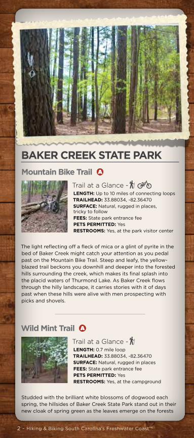
BAKER CREEK STATE PARK Mountain Bike Trail A
Trail at a Glance -LENGTH: Up to 10 miles of connecting loops TRAILHEAD: 33.88034, -82.36470SURFACE: Natural, rugged in places, tricky to followFEES: State park entrance feePETS PERMITTED: YesRESTROOMS: Yes, at the park visitor center
The light reflecting off a fleck of mica or a glint of pyrite in the bed of Baker Creek might catch your attention as you pedal past on the Mountain Bike Trail. Steep and leafy, the yellow-blazed trail beckons you downhill and deeper into the forested hills surrounding the creek, which makes its final splash into the placid waters of Thurmond Lake. As Baker Creek flows through the hilly landscape, it carries stories with it of days past when these hills were alive with men prospecting with picks and shovels.
Wild Mint Trail A
Trail at a Glance -LENGTH: 0.7 mile loop TRAILHEAD: 33.88034, -82.36470SURFACE: Natural, rugged in placesFEES: State park entrance feePETS PERMITTED: YesRESTROOMS: Yes, at the campground
Studded with the brilliant white blossoms of dogwood each spring, the hillsides of Baker Creek State Park stand out in their new cloak of spring green as the leaves emerge on the forests
blanketing the slopes. In its spring finery, the Wild Mint Trail at Baker Creek State Park is a delight to walk, a fine introduction to the oak-hickory forest topping these rugged hills. The views across the lake make this 0.7-mile hike worthwhile.
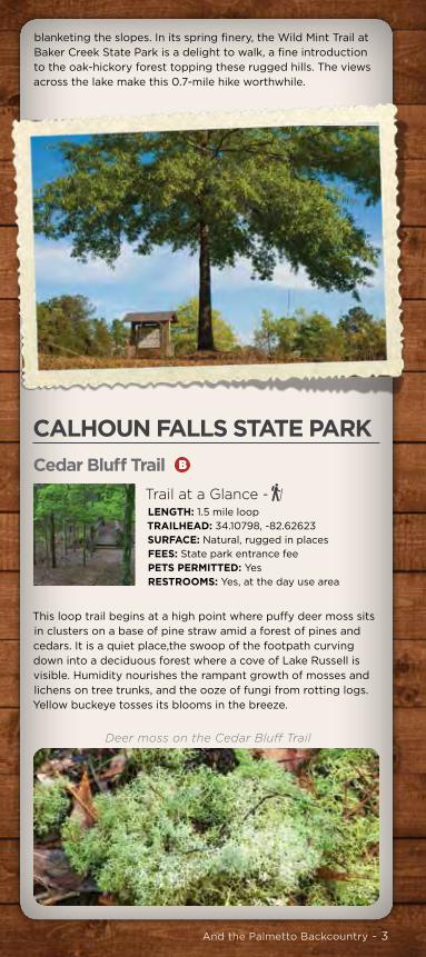
CALHOUN FALLS STATE PARK Cedar Bluff Trail B
Trail at a Glance -LENGTH: 1.5 mile loop TRAILHEAD: 34.10798, -82.62623SURFACE: Natural, rugged in placesFEES: State park entrance feePETS PERMITTED: YesRESTROOMS: Yes, at the day use area
This loop trail begins at a high point where puffy deer moss sits in clusters on a base of pine straw amid a forest of pines and cedars. It is a quiet place,the swoop of the footpath curving down into a deciduous forest where a cove of Lake Russell is visible. Humidity nourishes the rampant growth of mosses and lichens on tree trunks, and the ooze of fungi from rotting logs. Yellow buckeye tosses its blooms in the breeze.
And the Palmetto Backcountry - 3
BAKER CREEK STATE PARK Mountain Bike Trail A
Trail at a Glance -LENGTH: Up to 10 miles of connecting loops TRAILHEAD: 33.88034, -82.36470SURFACE: Natural, rugged in places, tricky to followFEES: State park entrance feePETS PERMITTED: YesRESTROOMS: Yes, at the park visitor center
The light reflecting off a fleck of mica or a glint of pyrite in the bed of Baker Creek might catch your attention as you pedal past on the Mountain Bike Trail. Steep and leafy, the yellow-blazed trail beckons you downhill and deeper into the forested hills surrounding the creek, which makes its final splash into the placid waters of Thurmond Lake. As Baker Creek flows through the hilly landscape, it carries stories with it of days past when these hills were alive with men prospecting with picks and shovels.
Wild Mint Trail A
Trail at a Glance -LENGTH: 0.7 mile loop TRAILHEAD: 33.88034, -82.36470SURFACE: Natural, rugged in placesFEES: State park entrance feePETS PERMITTED: YesRESTROOMS: Yes, at the campground
Studded with the brilliant white blossoms of dogwood each spring, the hillsides of Baker Creek State Park stand out in their new cloak of spring green as the leaves emerge on the forests
blanketing the slopes. In its spring finery, the Wild Mint Trail at Baker Creek State Park is a delight to walk, a fine introduction to the oak-hickory forest topping these rugged hills. The views across the lake make this 0.7-mile hike worthwhile.
CALHOUN FALLS STATE PARK Cedar Bluff Trail B
Trail at a Glance -LENGTH: 1.5 mile loop TRAILHEAD: 34.10798, -82.62623SURFACE: Natural, rugged in placesFEES: State park entrance feePETS PERMITTED: YesRESTROOMS: Yes, at the day use area
This loop trail begins at a high point where puffy deer moss sits in clusters on a base of pine straw amid a forest of pines and cedars. It is a quiet place,the swoop of the footpath curving down into a deciduous forest where a cove of Lake Russell is visible. Humidity nourishes the rampant growth of mosses and lichens on tree trunks, and the ooze of fungi from rotting logs. Yellow buckeye tosses its blooms in the breeze.
Deer moss on the Cedar Bluff Trail

4 - Hiking & Biking South Carolina’s Freshwater Coast™
Mariners Nature Trail B
Trail at a Glance -LENGTH: 0.25 mile linear TRAILHEAD: 34.10042, -82.61947 (park store), 34.10798, -82.62623 (campground)SURFACE: Natural with numerous bridges and stepsFEES: State park entrance feePETS PERMITTED: YesRESTROOMS: Yes, at the camp store and in the campground
Although the Mariners Nature Trail is a very short walk, it provides unique perspectives on Lake Russell and the forest sloping down to meet its waters. Now, the placid waters of the lake stretch nearly 27,000 acres across a once fertile valley. As the trail drops down the bluffs via a series of stairways to lake level, it affords scenic views across coves in the lake.
JOHN DE LA HOWE SCHOOLDe La Howe Interpretive Trail C
Trail at a Glance -LENGTH: 1.6 mile loop TRAILHEAD: 33.95585, -82.42372SURFACE: NaturalFEES: NonePETS PERMITTED: YesRESTROOMS: None
This trail starts out from The Barn, where the school’s dairy once kept children busy. The trail first drops into a valley rich with delicate wildflowers and then climbs up into the deeply forested hillside. Listen to the calls of songbirds echo through the forest. Look into the forest floor for subtle marvels of nature: the nodding blooms of trillium, the head of a morel mushroom peeping out of the leaf litter, the glistening form of jelly-leaf fungus swarming around a decaying branch.
Lethe Interpretive Trail C
Trail at a Glance -LENGTH: 1.6 mile loop TRAILHEAD: 33.95585, -82.42372SURFACE: NaturalFEES: NonePETS PERMITTED: YesRESTROOMS: None
Upon his death in 1797, Dr. John de la Howe left his estate to South Carolina to become a school for local poor and orphaned children. On the campus of the modern day John de la Howe School, the half-mile Lethe Interpretive Trail showcases two South Carolina gems: archaeological sites interpreted at Lethe Plantation, established by John de la Howe in 1769, and the old growth forest surrounding it, notable as a National Natural Landmark.
HICKORY KNOB RESORT STATE PARK
Beaver Run Trail D
Trail at a Glance -LENGTH: 2.3 milesTRAILHEAD: 33.87888, -82.43176 (at lodge), 33.89198, -82.42191 (at skeet range)SURFACE: Natural, optimized for mountain bikesFEES: NonePETS PERMITTED: YesRESTROOMS: At the main visitor center at the Hickory Knob Lodge
The most gentle of the park’s trails, the 2.3-mile Beaver Run Trail provides an easy mountain bike ride for beginners. It’s the perfect setting for a jog, an early morning run, or a meditative walk, providing an immersion in the natural history of South Carolina’s Piedmont. As the trail dips down to the edge of Strom Thurmond Lake, it enters leafy stretches of floodplain forest, where red maple, sweetgum, and tupelo dominate.

And the Palmetto Backcountry - 5
Mariners Nature Trail B
Trail at a Glance -LENGTH: 0.25 mile linear TRAILHEAD: 34.10042, -82.61947 (park store), 34.10798, -82.62623 (campground)SURFACE: Natural with numerous bridges and stepsFEES: State park entrance feePETS PERMITTED: YesRESTROOMS: Yes, at the camp store and in the campground
Although the Mariners Nature Trail is a very short walk, it provides unique perspectives on Lake Russell and the forest sloping down to meet its waters. Now, the placid waters of the lake stretch nearly 27,000 acres across a once fertile valley. As the trail drops down the bluffs via a series of stairways to lake level, it affords scenic views across coves in the lake.
JOHN DE LA HOWE SCHOOLDe La Howe Interpretive Trail C
Trail at a Glance -LENGTH: 1.6 mile loop TRAILHEAD: 33.95585, -82.42372SURFACE: NaturalFEES: NonePETS PERMITTED: YesRESTROOMS: None
This trail starts out from The Barn, where the school’s dairy once kept children busy. The trail first drops into a valley rich with delicate wildflowers and then climbs up into the deeply forested hillside. Listen to the calls of songbirds echo through the forest. Look into the forest floor for subtle marvels of nature: the nodding blooms of trillium, the head of a morel mushroom peeping out of the leaf litter, the glistening form of jelly-leaf fungus swarming around a decaying branch.
Lethe Interpretive Trail C
Trail at a Glance -LENGTH: 1.6 mile loop TRAILHEAD: 33.95585, -82.42372SURFACE: NaturalFEES: NonePETS PERMITTED: YesRESTROOMS: None
Upon his death in 1797, Dr. John de la Howe left his estate to South Carolina to become a school for local poor and orphaned children. On the campus of the modern day John de la Howe School, the half-mile Lethe Interpretive Trail showcases two South Carolina gems: archaeological sites interpreted at Lethe Plantation, established by John de la Howe in 1769, and the old growth forest surrounding it, notable as a National Natural Landmark.
HICKORY KNOB RESORT STATE PARK
Beaver Run Trail D
Trail at a Glance -LENGTH: 2.3 milesTRAILHEAD: 33.87888, -82.43176 (at lodge), 33.89198, -82.42191 (at skeet range)SURFACE: Natural, optimized for mountain bikesFEES: NonePETS PERMITTED: YesRESTROOMS: At the main visitor center at the Hickory Knob Lodge
The most gentle of the park’s trails, the 2.3-mile Beaver Run Trail provides an easy mountain bike ride for beginners. It’s the perfect setting for a jog, an early morning run, or a meditative walk, providing an immersion in the natural history of South Carolina’s Piedmont. As the trail dips down to the edge of Strom Thurmond Lake, it enters leafy stretches of floodplain forest, where red maple, sweetgum, and tupelo dominate.

6 - Hiking & Biking South Carolina’s Freshwater Coast™
Lakeview Trail D
Trail at a Glance -LENGTH: 6.7 milesTRAILHEAD: 33.88240, -82.41377SURFACE: Natural, optimized for mountain bikesFEES: NonePETS PERMITTED: YesRESTROOMS: At the main visitor center at the Hickory Knob Lodge
For mountain bikers, the 6.7-mile Lakeview Trail provides a balance of technical challenges with scenery unsurpassed on any of the region’s rides. This single track roller-coaster of a trail showcases scenic views above and along the shoreline of Strom Thurmond Lake in Hickory Knob Resort State Park. The tricky pedaling on this trail is well worth the experience. From promontories on the hillsides, there are panoramas of the massive lake below.
Turkey Ridge Trail D
Trail at a Glance -LENGTH: 1.7 milesTRAILHEAD: 33.88262, -82.41348SURFACE: Natural, optimized for mountain bikesFEES: NonePETS PERMITTED: YesRESTROOMS: At the main visitor center at the Hickory Knob Lodge
The Turkey Ridge Trail at Hickory Knob State Park is a short loop, which means when cyclists stay away, hikers can play. This walk in the woods offers steep ups and downs and switchbacks as it traverses the oak-hickory forest so common in the uplands of the South Carolina Piedmont. Splashing across a couple of streams is required to complete the loop. When the trail is dry and open for cycling, it provides a moderately technical challenge.
LAKE GREENWOOD NATURE TRAIL E
Trail at a Glance -LENGTH: 0.7 mile loopTRAILHEAD: 34.19686, -81.95248SURFACE: NaturalFEES: State park entrance feePETS PERMITTED: YesRESTROOMS: Yes, at the campground
Beneath the deep shade of oaks and hickories, this trail descends down to a cove along the lake’s edge before climbing up to the crest of a peninsula that juts out into Lake Greenwood. From this vantage point, the outline of the lake is visible in three directions. Fallen pines bear testament to the ravages of the Southern pine bark beetle through the region. But nature fills in the gaps, with young trees racing to create a new canopy.
Rain lily on the Lakeview Trail

And the Palmetto Backcountry - 7
LAKE GREENWOOD NATURE TRAIL E
Trail at a Glance -LENGTH: 0.7 mile loopTRAILHEAD: 34.19686, -81.95248SURFACE: NaturalFEES: State park entrance feePETS PERMITTED: YesRESTROOMS: Yes, at the campground
Beneath the deep shade of oaks and hickories, this trail descends down to a cove along the lake’s edge before climbing up to the crest of a peninsula that juts out into Lake Greenwood. From this vantage point, the outline of the lake is visible in three directions. Fallen pines bear testament to the ravages of the Southern pine bark beetle through the region. But nature fills in the gaps, with young trees racing to create a new canopy.
Gully crossing on the Lake Greenwood Nature Trail

8 - Hiking & Biking South Carolina’s Freshwater Coast™
LAURENS COUNTY BICYCLE TRAIL F
Trail at a Glance -LENGTH: 70 mile loop TRAILHEAD: 34.679536, -82.187459SURFACE: PavedFEES: NonePETS PERMITTED: NoRESTROOMS: None
The primary loop connects Fountain Inn, Owings, Gray Court, Laurens and Clinton; then returns to Fountain Inn via routes in northeastern Laurens County. Riders can begin at any point along the loop.
LAURENS COUNTY PARK NATURE TRAIL G
Trail at a Glance -LENGTH: 0.7 mile loop TRAILHEAD: 34.50199, -81.95072SURFACE: Unpaved, partially gradedFEES: NonePETS PERMITTED: YesRESTROOMS: Yes, adjoining the playground
A worn path leads to a forested hillside above the pond. Continuing down to an earthen dam and across it, the path provides a prime spot for watching turtles paddle through the waters. This trail then meanders beneath the oaks and hickories down to the boundary of the park, the burbling brook, where the crayfish huddle on the sand and gravel bottom, pondering their next meal. A cyclist enjoying the smooth ride along the paved trail

And the Palmetto Backcountry - 9
LAURENS COUNTY BICYCLE TRAIL F
Trail at a Glance -LENGTH: 70 mile loop TRAILHEAD: 34.679536, -82.187459SURFACE: PavedFEES: NonePETS PERMITTED: NoRESTROOMS: None
The primary loop connects Fountain Inn, Owings, Gray Court, Laurens and Clinton; then returns to Fountain Inn via routes in northeastern Laurens County. Riders can begin at any point along the loop.
LAURENS COUNTY PARK NATURE TRAIL G
Trail at a Glance -LENGTH: 0.7 mile loop TRAILHEAD: 34.50199, -81.95072SURFACE: Unpaved, partially gradedFEES: NonePETS PERMITTED: YesRESTROOMS: Yes, adjoining the playground
A worn path leads to a forested hillside above the pond. Continuing down to an earthen dam and across it, the path provides a prime spot for watching turtles paddle through the waters. This trail then meanders beneath the oaks and hickories down to the boundary of the park, the burbling brook, where the crayfish huddle on the sand and gravel bottom, pondering their next meal.
Crawfish in the creek

10 - Hiking & Biking South Carolina’s Freshwater Coast™
LITTLE RIVER TRAIL H
Trail at a Glance -LENGTH: 1.1 miles linear TRAILHEAD: 34.49870, -82.00857SURFACE: Paved, wheelchair accessibleFEES: NonePETS PERMITTED: YesRESTROOMS: Yes, at Little River Park
With the Little River flowing right through the middle of this historic town—established as the county seat in 1785—Laurens had a ready-made corridor for public enjoyment. With the help of landscape designer William Moss, a linear park emerged along this tributary of the Saluda River. This trail takes a meandering route through downtown Laurens, where it is a magnet for families. Each segment of the trail provides a different perspective of the river as it winds its way south.
MUSGROVE MILL STATE HISTORIC SITEBattlefield Trail I
Trail at a Glance - LENGTH: 1.5 miles linear TRAILHEAD: 34.35540, -81.51256SURFACE: UnpavedFEES: NonePETS PERMITTED: Dogs on leashes less than 6 feet are allowedRESTROOMS: At the Musgrove Mill State Historic Site Visitors Center
This trail begins on the ADA boardwalk, which leads to the overlook at Horseshoe Falls. The trail leaves the overlook and goes out to the battlefield area. Along the way are interpretive waysides that explain the American Revolutionary War battle of Musgrove Mill which occurred on August 19, 1780. This trail has changes in elevation and areas that are not shaded. Closed toed shoes and water are necessary.
British Encampment Trail I
Trail at a Glance - LENGTH: 1 mile linearTRAILHEAD: 34.35540, -81.51140SURFACE: UnpavedFEES: NonePETS PERMITTED: Dogs on leashes less than 6 feet are allowedRESTROOMS: At the Musgrove Mill State Historic Site Visitors Center
This easy, one mile loop starts in the parking lot and runs along the Enoree River much of the way. The trail has interpretive waysides that educate about the homestead of the Musgrove family, the British Encampment in the summer of 1780, 18th century transportation, and the gristmill that was located on the river.
Open air stage and seating area along the Little River Trail

And the Palmetto Backcountry - 11
LITTLE RIVER TRAIL H
Trail at a Glance -LENGTH: 1.1 miles linear TRAILHEAD: 34.49870, -82.00857SURFACE: Paved, wheelchair accessibleFEES: NonePETS PERMITTED: YesRESTROOMS: Yes, at Little River Park
With the Little River flowing right through the middle of this historic town—established as the county seat in 1785—Laurens had a ready-made corridor for public enjoyment. With the help of landscape designer William Moss, a linear park emerged along this tributary of the Saluda River. This trail takes a meandering route through downtown Laurens, where it is a magnet for families. Each segment of the trail provides a different perspective of the river as it winds its way south.
MUSGROVE MILL STATE HISTORIC SITEBattlefield Trail I
Trail at a Glance - LENGTH: 1.5 miles linear TRAILHEAD: 34.35540, -81.51256SURFACE: UnpavedFEES: NonePETS PERMITTED: Dogs on leashes less than 6 feet are allowedRESTROOMS: At the Musgrove Mill State Historic Site Visitors Center
This trail begins on the ADA boardwalk, which leads to the overlook at Horseshoe Falls. The trail leaves the overlook and goes out to the battlefield area. Along the way are interpretive waysides that explain the American Revolutionary War battle of Musgrove Mill which occurred on August 19, 1780. This trail has changes in elevation and areas that are not shaded. Closed toed shoes and water are necessary.
British Encampment Trail I
Trail at a Glance - LENGTH: 1 mile linearTRAILHEAD: 34.35540, -81.51140SURFACE: UnpavedFEES: NonePETS PERMITTED: Dogs on leashes less than 6 feet are allowedRESTROOMS: At the Musgrove Mill State Historic Site Visitors Center
This easy, one mile loop starts in the parking lot and runs along the Enoree River much of the way. The trail has interpretive waysides that educate about the homestead of the Musgrove family, the British Encampment in the summer of 1780, 18th century transportation, and the gristmill that was located on the river.

12 - Hiking & Biking South Carolina’s Freshwater Coast™
NATIONAL WILD TURKEY FEDERATIONOutdoor Education Center J
Trail at a Glance -LENGTH: Loops of 0.6 mile to 1.6 milesTRAILHEAD: 33.76650, -81.90510SURFACE: Natural on Ed’s Trail, gravel roads elsewhereFEES: None for the trails. Non-members pay an admission fee for the museumPETS PERMITTED: NoRESTROOMS: At the adjacent NWTF Headquarters and in the picnic pavilion
A walk along Ed’s Trail, named for a longtime volunteer and former regional director of National Wild Turkey Federation, provides visitors with an understanding of the ecosystems and trees that blanket the rolling hills of this corner of South Carolina. Ed’s Trail is a footpath that meanders through several habitats within sight of the gentle course of a woodland stream.
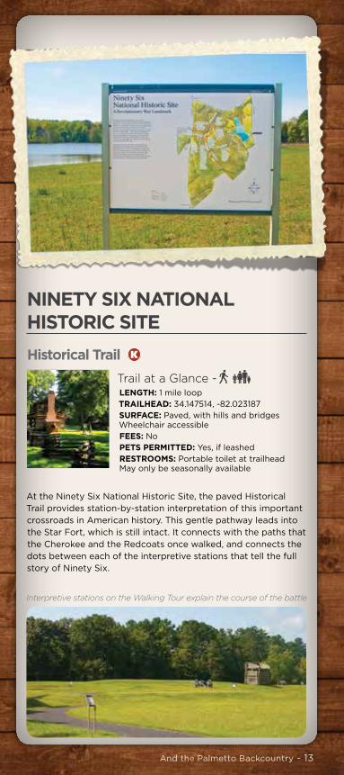
NINETY SIX NATIONAL HISTORIC SITEHistorical Trail K
Trail at a Glance -LENGTH: 1 mile loop TRAILHEAD: 34.147514, -82.023187SURFACE: Paved, with hills and bridges Wheelchair accessible FEES: NoPETS PERMITTED: Yes, if leashedRESTROOMS: Portable toilet at trailhead May only be seasonally available
At the Ninety Six National Historic Site, the paved Historical Trail provides station-by-station interpretation of this important crossroads in American history. This gentle pathway leads into the Star Fort, which is still intact. It connects with the paths that the Cherokee and the Redcoats once walked, and connects the dots between each of the interpretive stations that tell the full story of Ninety Six.
Outside the National Wild Turkey Foundation headquarters
And the Palmetto Backcountry - 13
NATIONAL WILD TURKEY FEDERATIONOutdoor Education Center J
Trail at a Glance -LENGTH: Loops of 0.6 mile to 1.6 milesTRAILHEAD: 33.76650, -81.90510SURFACE: Natural on Ed’s Trail, gravel roads elsewhereFEES: None for the trails. Non-members pay an admission fee for the museumPETS PERMITTED: NoRESTROOMS: At the adjacent NWTF Headquarters and in the picnic pavilion
A walk along Ed’s Trail, named for a longtime volunteer and former regional director of National Wild Turkey Federation, provides visitors with an understanding of the ecosystems and trees that blanket the rolling hills of this corner of South Carolina. Ed’s Trail is a footpath that meanders through several habitats within sight of the gentle course of a woodland stream.
NINETY SIX NATIONAL HISTORIC SITEHistorical Trail K
Trail at a Glance -LENGTH: 1 mile loop TRAILHEAD: 34.147514, -82.023187SURFACE: Paved, with hills and bridges Wheelchair accessible FEES: NoPETS PERMITTED: Yes, if leashedRESTROOMS: Portable toilet at trailhead May only be seasonally available
At the Ninety Six National Historic Site, the paved Historical Trail provides station-by-station interpretation of this important crossroads in American history. This gentle pathway leads into the Star Fort, which is still intact. It connects with the paths that the Cherokee and the Redcoats once walked, and connects the dots between each of the interpretive stations that tell the full story of Ninety Six.
Interpretive stations on the Walking Tour explain the course of the battle

14 - Hiking & Biking South Carolina’s Freshwater Coast™
Star Fort Pond K
Trail at a Glance -LENGTH: 1.5 mile loop TRAILHEAD: 34.14612, -82.00637SURFACE: Natural, Muddy in places FEES: NoPETS PERMITTED: YesRESTROOMS: Portable toilet at trailhead May only be seasonally available
From the shade of the forested shoreline, watch for turtles sunning on fallen logs. Songbirds flit between stands of native bamboo that line a stagnant channel in the floodplain forest. Great blue herons stalk the shallows, looking for an easy meal. Along the route, the cool shade of a picnic shelter beckons, a place to sit and ponder the passage of time and the changes brought to this landscape along the ancient Cherokee Path.
SAVANNAH VALLEY RAILROAD TRAIL L
Trail at a Glance -LENGTH: 9.35 miles linear (complete)2.5 miles of trail is on Huguenot Highway (paved) TRAILHEAD: 33.92296, -82.34205 (Brown Trailhead); 33.92307, -82.37315 (Badwell Cemetery); 33.97102, -82.46700 (Willington)ACCESS POINTS: 33.92231, -82.41237 (Huguenot Parkway); 33.92818, -82.42214 (SC 7); 33.97102, -82.46700 (Willington)SURFACE: Hardpacked former railroad bed most suitable for hikers and fat-tire bicyclesFEES: NonePETS PERMITTED: Yes (no horses or motorized vehicles)RESTROOMS: At Willington Historical Center
The Savannah Valley Railroad Trail leads visitors past historic sites along a well-graded former rail line, making this the most
comfortable bicycle route in the region. The trail is deeply shaded for most of its route and easy for hikers and fat-tire cyclists to follow. The history it touches makes the experience especially enjoyable. Watch for the ancient posts and mile markers all along the trail.
STEVENS CREEK HERITAGE PRESERVE M
Trail at a Glance -LENGTH: 1.9 mile loopTRAILHEAD: 33.68551, -82.16267SURFACE: Natural, rugged and rocky in placesFEES: NonePETS PERMITTED: YesRESTROOMS: None
On the descent from the trailhead, it’s hard to envision the magic that Stevens Creek Heritage Preserve promises. But as the plunge downhill accelerates, there is a shift in the air. Literally. Cool breezes sweep down the waterways, which merge at a point where the loop begins, which is where fifteen rare and several endangered plant species call these cool sheltered spaces home. Access to the trail is possible from Hamilton Branch State Park.

And the Palmetto Backcountry - 15
Star Fort Pond K
Trail at a Glance -LENGTH: 1.5 mile loop TRAILHEAD: 34.14612, -82.00637SURFACE: Natural, Muddy in places FEES: NoPETS PERMITTED: YesRESTROOMS: Portable toilet at trailhead May only be seasonally available
From the shade of the forested shoreline, watch for turtles sunning on fallen logs. Songbirds flit between stands of native bamboo that line a stagnant channel in the floodplain forest. Great blue herons stalk the shallows, looking for an easy meal. Along the route, the cool shade of a picnic shelter beckons, a place to sit and ponder the passage of time and the changes brought to this landscape along the ancient Cherokee Path.
SAVANNAH VALLEY RAILROAD TRAIL L
Trail at a Glance -LENGTH: 9.35 miles linear (complete)2.5 miles of trail is on Huguenot Highway (paved) TRAILHEAD: 33.92296, -82.34205 (Brown Trailhead); 33.92307, -82.37315 (Badwell Cemetery); 33.97102, -82.46700 (Willington)ACCESS POINTS: 33.92231, -82.41237 (Huguenot Parkway); 33.92818, -82.42214 (SC 7); 33.97102, -82.46700 (Willington)SURFACE: Hardpacked former railroad bed most suitable for hikers and fat-tire bicyclesFEES: NonePETS PERMITTED: Yes (no horses or motorized vehicles)RESTROOMS: At Willington Historical Center
The Savannah Valley Railroad Trail leads visitors past historic sites along a well-graded former rail line, making this the most
comfortable bicycle route in the region. The trail is deeply shaded for most of its route and easy for hikers and fat-tire cyclists to follow. The history it touches makes the experience especially enjoyable. Watch for the ancient posts and mile markers all along the trail.
STEVENS CREEK HERITAGE PRESERVE M
Trail at a Glance -LENGTH: 1.9 mile loopTRAILHEAD: 33.68551, -82.16267SURFACE: Natural, rugged and rocky in placesFEES: NonePETS PERMITTED: YesRESTROOMS: None
On the descent from the trailhead, it’s hard to envision the magic that Stevens Creek Heritage Preserve promises. But as the plunge downhill accelerates, there is a shift in the air. Literally. Cool breezes sweep down the waterways, which merge at a point where the loop begins, which is where fifteen rare and several endangered plant species call these cool sheltered spaces home. Access to the trail is possible from Hamilton Branch State Park.
Ferns dominate the growth along the streams

16 - Hiking & Biking South Carolina’s Freshwater Coast™
SUMTER NATIONAL FOREST Forks Area Trail System N
Trail at a Glance -LENGTH: 37 miles in six loopsTRAILHEAD: 33.60847, -82.07963SURFACE: Natural, rugged in places, tricky to followFEES: State park entrance feePETS PERMITTED: YesRESTROOMS: Yes, at the park visitor center
A brisk ride down the shared trail leading to where all six trails splinter off into the woods becomes a gentle introduction to the terrain ahead, the route deeply shaded by deciduous forest. Little whoop-de-doos start right away, with a few rocks and roots for good measure. But no worries. The trail is well worn, so you can keep your eyes on what’s coming up.
Horn Creek Trail O
Trail at a Glance -LENGTH: 5.4 mile loop TRAILHEAD: 33.72630, -82.03950 (Lick Fork Lake) or 33.713906, -82.030232 (FR 634)SURFACE: Natural, optimized for mountain bikingFEES: Recreation Area fee if accessed from the Lick Fork Lake trailheadPETS PERMITTED: YesRESTROOMS: At Lick Fork Lake Recreation Area (fee)
At the top of a ridge on the Horn Creek Trail, the panorama of the Piedmont stretches out below. Its gentle folds and forests cover the footfalls of settlers long past. One of the region’s most scenic mountain bike trails, the Horn Creek Trail alternates between gentle hills and steep pitches. It’s worth the occasional dismount to take in the scenery of Piedmont azalea and mountain laurel that line the steep banks of Lick Fork Creek.

And the Palmetto Backcountry - 17
SUMTER NATIONAL FOREST Forks Area Trail System N
Trail at a Glance -LENGTH: 37 miles in six loopsTRAILHEAD: 33.60847, -82.07963SURFACE: Natural, rugged in places, tricky to followFEES: State park entrance feePETS PERMITTED: YesRESTROOMS: Yes, at the park visitor center
A brisk ride down the shared trail leading to where all six trails splinter off into the woods becomes a gentle introduction to the terrain ahead, the route deeply shaded by deciduous forest. Little whoop-de-doos start right away, with a few rocks and roots for good measure. But no worries. The trail is well worn, so you can keep your eyes on what’s coming up.
Horn Creek Trail O
Trail at a Glance -LENGTH: 5.4 mile loop TRAILHEAD: 33.72630, -82.03950 (Lick Fork Lake) or 33.713906, -82.030232 (FR 634)SURFACE: Natural, optimized for mountain bikingFEES: Recreation Area fee if accessed from the Lick Fork Lake trailheadPETS PERMITTED: YesRESTROOMS: At Lick Fork Lake Recreation Area (fee)
At the top of a ridge on the Horn Creek Trail, the panorama of the Piedmont stretches out below. Its gentle folds and forests cover the footfalls of settlers long past. One of the region’s most scenic mountain bike trails, the Horn Creek Trail alternates between gentle hills and steep pitches. It’s worth the occasional dismount to take in the scenery of Piedmont azalea and mountain laurel that line the steep banks of Lick Fork Creek.
Lick Fork Trail P
Trail at a Glance -LENGTH: 1.8 mile loop TRAILHEAD: 33.72630, -82.03950 SURFACE: Natural, includes rock hopping across streamsFEES: Recreation Area fee if accessed from the Lick Fork Lake trailheadPETS PERMITTED: YesRESTROOMS: At Lick Fork Lake Recreation Area (fee)
Framed by azaleas in bloom, Lick Fork Lake sparkles with beauty. Trapped between steep hills, it’s a place for families to picnic, anglers to cast a line, and Canadian geese to raise their young. Turtles find sunny spots to warm themselves. And hikers find Lick Fork Trail, a 1.8 mile loop, reminiscent of a walk at higher elevations. Along the footpath, wildflowers delight. Dwarf cinquefoil paints yellow dots across the forest floor, and rain lilies cluster along rocky ledges.
Long Cane Horse Trail Q
Trail at a Glance -LENGTH: Up to a 26.7 mile loopTRAILHEAD: 34.09455, -82.28739 (Fell Camp), 34.170071, -82.278958 (Beulah Church Rd)SURFACE: Natural singletrack, shared with equestrians and hikersFEES: Recreation Area fee for day use parking at Fell CampPETS PERMITTED: YesRESTROOMS: At Fell Camp
This multi-use loop trail is a favorite for mountain bikers to tackle some distance riding in the woods. The 655-acre Long Cane Scenic Area, containing both ancient trees like the state champion shagbark hickory and a significant canebrake thicket of giant cane, forms the center around which the 26.7-mile Long Cane Horse Trail revolves. Shorter loops of 16.7 miles and 15.1 miles are possible.
Parson’s Mountain Recreation Area R
Trail at a Glance -LENGTH: 4 mile loop TRAILHEAD: 34.09778,-82.35730SURFACE: Natural, mostly clayFEES: Daily parking feePETS PERMITTED: YesRESTROOMS: At bath house and campground
Home to an 800-foot summit, Parson’s Mountain Recreation Area offers a moderately difficult loop around Parson’s Mountain Lake. The four-mile loop includes woods overflowing with flora such as sparkleberry, redbud, wild ginger, and dogwood. Visitors wanting a tougher hike can take a branch of the trail passing by Civil War-era gold mines on the way to the summit.

18 - Hiking & Biking South Carolina’s Freshwater Coast™
TEN GOVERNORS TRAIL V
Trail at a Glance -LENGTH: 1 mile linear TRAILHEAD: 33.78169, -81.91976 (Slade Lake) or 33.788447, -81.925257 (Main St)SURFACE: Paved and wheelchair accessible FEES: NonePETS PERMITTED: YesRESTROOMS: None
A walk or ride along the Ten Governors Trail ensures your acquaintance with all ten of Edgefield’s favorite sons. It’s a pleasant two-mile round-trip to walk from the start of this the trail – adjoining the memorial to Strom Thurmond – to its end in downtown Edgefield at Main Street and back again. The trail starts out as a boardwalk over Slade Lake and then becomes a paved path that curves past historic homes and gubernatorial memorials that paint a picture of public service across three centuries.
Stevens Creek / Modoc Trail S
Trail at a Glance -LENGTH: 5.5 miles linear (11 mile round-trip)TRAILHEAD: 33.72956, -82.18422SURFACE: Natural, optimized for mountain bikingFEES: NonePETS PERMITTED: YesRESTROOMS: None
The Modoc Trail is one of the most technical mountain bike courses in the region, thanks to the rugged terrain along a stretch of Stevens Creek and the clever trail routing that makes use of the topography. Rock-hopping awaits at each creek crossing. With its combination of beauty and tough terrain, the Modoc Trail is one of the top highlights of this region for mountain bikers. Access to the trail is possible from Hamilton Branch State Park.
Turkey Creek Trail T
Trail at a Glance -LENGTH: 7 miles linear TRAILHEAD: 33.79402, -82.14576 (Key Bridge)SURFACE: Natural, narrow singletrack optimized for mountain bikingFEES: NonePETS PERMITTED: YesRESTROOMS: None
Starting off in a deeply shaded forest on narrow singletrack that slips through lush greenery, the Turkey Creek Trail provides a great round-trip destination for mountain bikers to put on some speed. Switchbacks, roots, creekside rocks, and logs provide some technical challenges but for the most part, it’s an easy, mostly flat ride. Bridges provide crossings of the tributaries that flow into Turkey Creek, including one of the longest wooden bridges in the region. Access to the trail is possible from Hamilton Branch State Park.
Wine Creek Trail U
Trail at a Glance -LENGTH: 5.5 miles linear
TRAILHEAD: 33.84130, -82.13294 (SC 283), 33.79402, -82.14576 (Key Bridge)
SURFACE: Natural, optimized for mountain bikingFEES: NonePETS PERMITTED: YesRESTROOMS: None
Following the gentle flow of Wine Creek as it winds its way for 5.5 miles through deciduous forests and around pine plantations to feed its waters into Turkey Creek, the Wine Creek Trail provides a shady and scenic ride for mountain bikers and a beautiful walk for hikers, with very little in the way of steep climbs. Several creek crossings mean some rock-hopping. Access to the trail is possible from Hamilton Branch State Park.

And the Palmetto Backcountry - 19
TEN GOVERNORS TRAIL V
Trail at a Glance -LENGTH: 1 mile linear TRAILHEAD: 33.78169, -81.91976 (Slade Lake) or 33.788447, -81.925257 (Main St)SURFACE: Paved and wheelchair accessible FEES: NonePETS PERMITTED: YesRESTROOMS: None
A walk or ride along the Ten Governors Trail ensures your acquaintance with all ten of Edgefield’s favorite sons. It’s a pleasant two-mile round-trip to walk from the start of this the trail – adjoining the memorial to Strom Thurmond – to its end in downtown Edgefield at Main Street and back again. The trail starts out as a boardwalk over Slade Lake and then becomes a paved path that curves past historic homes and gubernatorial memorials that paint a picture of public service across three centuries.
Milledge Luke Bonham Memorial on the Ten Governors Trail

20 - Hiking & Biking South Carolina’s Freshwater Coast™
TOWN OF NINETY SIX TRAIL WTrail at a Glance -LENGTH: 1.4 miles linear TRAILHEAD: 34.175119, -82.022911 (parking area at the Ninety Six Visitor Center)SURFACE: Paved and wheelchair accessible downtown, unpaved but graded elsewhereFEES: NonePETS PERMITTED: YesRESTROOMS: Yes, at the Ninety Six Visitor Center, downtown
Trains no longer stop traffic in Ninety Six in the middle of the day. They’ve been rerouted elsewhere. Where once was a railroad track, is now a place for families to take a walk and for cyclists to get a little respite from a road ride. This trail is mostly an unimproved path, but hardpacked and easy to ride, leading right through the heart of downtown. Its two ends are at the ends of town, so it’s a short route, with the Ninety Six Visitor Center anchoring its center.
East end of the Ninety Six Town Trail

And the Palmetto Backcountry - 21
LODGING – HOTELS & MOTELSABBEVILLE COUNTYABBEVILLA MOTEL ................................................ 864/459-5041801 East Greenwood St., Abbeville, SC 29620.
BELMONT INN ........................................................864/459-9625104 East Pickens St., Abbeville, SC 29620.
WESTBROOK MOTEL ............................................ 864/459-5533283 Hwy. 72 West, Abbeville, SC 29620.
EDGEFIELD COUNTYEDGEFIELD INN ...................................................... 803/637-2001702 Augusta Road (US 25), Edgefield, SC 29824. www.edgefieldinn.com.
GREENWOOD COUNTYAMERICA’S BEST VALUE INN .............................. 864/223-2838 1215 Bypass 72 NE, Greenwood, SC 29646.
BAYMONT INN & SUITES .....................................864/942-0002109 Enterprise Court, Greenwood, SC 29649.
BUDGET INN ............................................................864/223-19031605 Montague Ave., Greenwood, SC 29646.
DAYS INN ...................................................................864/223-1818230 Birchtree Drive, Greenwood, SC 29646. www.daysinn.com
ECONO LODGE ......................................................864/229-5329719 Bypass 72 NE, Greenwood, SC 29646. www.econolodge.com.
EXTENDED STAY MOTEL ..................................... 864/223-3979919 Montague Ave., Greenwood, SC 29646.
FAIRFIELD INN AND SUITES BY MARRIOTT ..... 864/330-3300527 Bypass 72 NW, Greenwood, SC 29649. www.marriott.com/grdfi.
GREENWOOD MOTEL ..........................................864/229-2595306 Montague Ave., Greenwood, SC 29649.
HAMPTON INN ...................... 864/388-9595; 1-800/HAMPTON1624 Bypass 72 NE, Greenwood, SC 29649. www.hamptoninn.com.
HOLIDAY INN EXPRESS .......................................864/223-2296110 Birchtree Dr., Greenwood, SC 29649. www.holidayinnexpress.com.
IDEAL MOTEL .........................................................864/229-66331506 US Hwy. 221/SC 72, Greenwood, SC 29649.
QUALITY INN .........................................................864/229-5329719 Bypass 72 NE, Greenwood, SC 29646.
RELAX INN ..............................................................864/229-03991216 Montague Ave., Greenwood, SC 29646.
LAURENS COUNTYBUDGET LODGE .................................................... 864/682-9573804 Enoree Rd., I-385, Exit 9, Laurens, SC 29360.
COMFORT INN AND SUITES ................................. 864/833-180012865 Hwy. 56 N, I-26 and Hwy. 56, Clinton, SC 29325. www.comfortinn.com.
TOWN OF NINETY SIX TRAIL WTrail at a Glance -LENGTH: 1.4 miles linear TRAILHEAD: 34.175119, -82.022911 (parking area at the Ninety Six Visitor Center)SURFACE: Paved and wheelchair accessible downtown, unpaved but graded elsewhereFEES: NonePETS PERMITTED: YesRESTROOMS: Yes, at the Ninety Six Visitor Center, downtown
Trains no longer stop traffic in Ninety Six in the middle of the day. They’ve been rerouted elsewhere. Where once was a railroad track, is now a place for families to take a walk and for cyclists to get a little respite from a road ride. This trail is mostly an unimproved path, but hardpacked and easy to ride, leading right through the heart of downtown. Its two ends are at the ends of town, so it’s a short route, with the Ninety Six Visitor Center anchoring its center.

22 - Hiking & Biking South Carolina’s Freshwater Coast™
DAYS INN ............................................................... 864/833-660012374 Hwy. 56 N, I-26 and Hwy. 56, Clinton, SC 29325.
HAMPTON INN .................864/938-1040 OR 1-800/HAMPTON12374 Hwy. 56 N, I-26 and Hwy. 56, Clinton, SC 29325.
QUALITY INN .......................................................... 864/833-5558I-26 at Exit 52, 105 Trade St., Clinton, SC 29325.
RAMADA INN .......................................................... 864/833-4916I-26 and Hwy. 56, Clinton, SC 29325.
MAGNOLIA INN .................................................... 864/984-0558621 N. Harper St., Laurens, SC 29360.
TRAVELERS INN ...................................................864/833-4400Hwy. 56 P. O. Box 1533, Clinton, SC 29325.
McCORMICK COUNTYBAR-MEL INN ...........................................................864/852-2971Hwy. 378 W, McCormick, SC 29835.
HICKORY KNOB STATE RESORT PARK ................ 800/491-1764Hwy. 378, 1591 Resort Drive, McCormick, SC 29835. www.playhickoryknob.com.
While the information contained in this brochure is periodically updated, no guarantee is given that the information provided is correct, and/or up-to-date. This is not an all-inclusive listing of lodging.
STATE PARKSCALHOUN FALLS STATE PARK ............................ 864/447-826746 Maintenance Shop Rd., Calhoun Falls, SC 29628
LAKE GREENWOOD STATE PARK ....................... 864/543-3535302 State Park Rd., Ninety Six, SC 29666
BAKER CREEK STATE PARK ................................. 864/443-2457863 Baker Creek Rd., McCormick, SC 29835
HAMILTON BRANCH STATE PARK ....................... 864/333-2223111 Campground Rd., Plum Branch, SC 29845
MUSGROVE MILL STATE HISTORIC SITE ............864/938-0100398 State Park Rd., Clinton, SC 29325
HICKORY KNOB STATE RESORT PARK ............... 864/391-24501591 Resort Dr., McCormick, SC 29835
MAKE YOUR RESERVATION AT A STATE PARK 1-866/345-PARK (7275)

www.scfreshwatercoasttrails.com800.849.9633
GET AWAY TO...
5 Lakefront State Parks on South Carolina’s Freshwater Coast™
15Privately Owned Campgrounds

24 - Hiking & Biking South Carolina’s Freshwater Coast™
Visit the South Carolina Welcome Centers for Traveler Assistance
OLD 96 DISTRICT TOURISM
A Part of South Carolina’s Freshwater Coast™
Promoting travel and tourism in Abbeville, Edgefield, Greenwood, Laurens, and McCormick Counties
800/849-9633 [email protected] www.scfreshwatercoasttrails.com
The palmetto tree used in South Carolina’s state logo is a tribute to the palmetto logs that were used to build Ft. Moultrie on Sullivan’s Island during the Revolutionary War. It’s said to have withstood bombardment from British warships extremely well. Palmetto is a soft wood and absorbed the blows from the cannon balls.

www.scfreshwatercoasttrails.com800.849.9633
Ever wonder what life was like before the cell phone? Where a remote was a location far away from it all and a
tweet was something you heard from a bird. Old 96 is o� the beaten path
and we’re proud of it. A� ordable accommodations? You bet. Scenic?
You got it. We’re home to South Carolina’s Freshwater Coast – a series of pristine lakes that stretch for over
60 miles. We welcome visits from outdoorsy people like you.
FIND IT. PARK IT.PITCH IT.
OLD-4377-1015-2500-EMED