hīhīaua precinct plan - whangarei · the precinct plan will inform the ... precinct planning is a...
TRANSCRIPT
1
Hīhīaua Precinct Plan

2
Prepared by:
Injoo Prentice - Strategic Planner Urban design input from:
Nick Karlovsky – Senior Specialist (Urban Design and Policy) Alicia Lawrie – Scholarship Student Reviewed by:
Dr Kerry Grundy – Team Leader – Futures Planning Heather Shannon – Strategic Planner
Adopted by Planning Committee 8 April 2015

3
Table of Contents 1. Part A: Background .............................................................................................................................. 7 1.1. Introduction .................................................................................................................................. 7 1.2. Description ................................................................................................................................... 8 1.3. History .......................................................................................................................................... 9 1.4. Present Uses ................................................................................................................................ 9
2. Part B: Constraints Analysis ............................................................................................................... 13 2.1. Flooding ..................................................................................................................................... 13 2.2. Land Instability ........................................................................................................................... 16 2.3. Geotechnical Constraints ............................................................................................................ 17 2.4. Potentially Contaminated Land ................................................................................................... 20 2.5. Reverse Sensitivity Issues .......................................................................................................... 21 2.6. Cultural/Historic Heritage ............................................................................................................ 22
2.6.1. Heritage Buildings, Sites and Objects .................................................................................. 22 2.6.2. Tangata Whenua ................................................................................................................ 23 2.6.3. Cultural Features ................................................................................................................ 24 2.6.4. Views/ View Shafts ............................................................................................................. 24
2.7. Natural Heritage ......................................................................................................................... 25 2.7.1. Biodiversity ......................................................................................................................... 25 2.7.2. Blue/Green Network ............................................................................................................ 25 2.7.3. Landscape .......................................................................................................................... 26 2.7.4. Heritage Trees .................................................................................................................... 26 2.7.5. Mangroves .......................................................................................................................... 26 2.7.6. Whangarei Harbour ............................................................................................................. 27 2.7.7. Water Quality ...................................................................................................................... 27
2.8. Land Ownership ......................................................................................................................... 28 3. Part C: Infrastructure Constraints Analysis .......................................................................................... 29 3.1. Core Infrastructure ...................................................................................................................... 29
3.1.1. Transport Infrastructure ....................................................................................................... 29 3.1.2. Solid Waste ........................................................................................................................ 30 3.1.3. Wastewater ......................................................................................................................... 30 3.1.4. Water .................................................................................................................................. 31 3.1.5. Stormwater Disposal ........................................................................................................... 31 3.1.6. Other Utilities ...................................................................................................................... 31 3.1.7. Parks and Reserves ............................................................................................................ 31
3.2. Community Infrastructure ............................................................................................................ 33 3.2.1. Health Care ........................................................................................................................ 33 3.2.2. Education ........................................................................................................................... 33 3.2.3. Emergency Services ........................................................................................................... 33 3.2.4. Community Facilities ........................................................................................................... 34
4. Part D: Planning Framework ............................................................................................................... 35 4.1. Operative Northland Regional Coastal Plan ................................................................................ 35 4.2. Operative Northland Water and Soil Plan .................................................................................... 36 4.3. Whangarei District Growth Strategy: Sustainable Futures 30/50 .................................................. 36 4.4. Whangarei Urban Growth Strategy ............................................................................................. 37 4.5. 20/20 Plus Whangarei CBD Development Guide ........................................................................ 38 4.6. Whangarei 20/20 Momentum ...................................................................................................... 40 4.7. Operative District Plan ................................................................................................................ 41 4.8. Open Space Strategy ................................................................................................................. 43 4.9. Walking and Cycling Strategy ..................................................................................................... 44 4.10. Parking Management Strategy .................................................................................................... 45 4.11. Urban Design/ Sense of Place .................................................................................................... 45
5. Part E: Hīhīaua Precinct Future Use ................................................................................................... 47 5.1. Introduction ................................................................................................................................ 47
4
5.2. Residential Capacity Analysis ..................................................................................................... 47 5.3. Density ....................................................................................................................................... 49 5.4. Housing Type ............................................................................................................................. 50
5.4.1. Medium/High Rise Apartments ............................................................................................ 50 5.4.2. Low Rise Apartments .......................................................................................................... 50 5.4.3. Mixed Use........................................................................................................................... 51 5.4.4. Semi Detached Town Houses ............................................................................................. 51 5.4.5. Terraced Housing ............................................................................................................... 51
5.5. Hīhīaua Precinct Development Scenarios ................................................................................... 52 5.5.1. Option 1- Do Nothing .......................................................................................................... 52 5.5.2. Option 2- Rezone the Hatea River Sub-Precinct to Mixed Use, by way of Plan Change. ...... 52 5.5.3. Option 3: Rezone the Hīhīaua Precinct to Mixed Use, by way of Plan Change. .................... 53 5.5.4. The Risk of Acting or Not Acting .......................................................................................... 54
5.6. Hīhīaua Precinct Concept Framework Plan ................................................................................. 55 5.6.1. Sub-Precinct Concept Plans ............................................................................................... 57 5.6.2. Built Form and Design Guidelines ....................................................................................... 64 5.6.3. Access and Movement ........................................................................................................ 74 5.6.4. Open Space ........................................................................................................................ 75 5.6.5. Community Facilities/Catalyst Projects ................................................................................ 77
5.7. Evaluation of Operative District Plan Provisions .......................................................................... 78 5.7.1. Business 2 Environment ..................................................................................................... 78 5.7.2. Town Basin Environment .................................................................................................... 79 5.7.3. Esplanade Reserve Rules ................................................................................................... 81 5.7.4. Subdivision Rules ............................................................................................................... 81
5.8. Land Use Rezoning and Redevelopment Programme ................................................................. 81 5.8.1. Indicative District Plan Provisions ........................................................................................ 82
6. Part F: Implementation and Monitoring ............................................................................................... 85 6.1. Implementation ........................................................................................................................... 85 6.2. Hīhīaua Precinct Redevelopment Programme............................................................................. 86
6.2.1. Hīhīaua Precinct Sequencing Plan ...................................................................................... 87 6.3. Relocation of Existing Activities in the Hīhīaua Precinct .............................................................. 88 6.4. Monitoring and Review ............................................................................................................... 89
Reference List ......................................................................................................................................... 90 Appendix 1: Geotechnical Assessment Hīhīaua Precinct Plan, by Tonkin and Taylor Appendix 2: HAIL Classification From Quotable Value: Category and Land Use Codes Appendix 3: Whangarei District Council HAIL Sites Located in the Hīhīaua Precinct

5
List of Figures Figure 1 Location Map: Hīhīaua Precinct ...................................................................................................... 7 Figure 2 Hīhīaua Precinct Today .................................................................................................................. 8 Figure 3 Land Use Activities Classified by ANZSIC, 2006 ........................................................................... 10 Figure 4 Vacant Premises, January 2013 ................................................................................................... 11 Figure 5 Hīhīaua Precinct Built Form .......................................................................................................... 12 Figure 6 Whangarei District Council Operative District Plan Flood Susceptibility ........................................ 13 Figure 7 Present Flood Risk Scenario ........................................................................................................ 14 Figure 8 Low Climate Change Scenario ..................................................................................................... 14 Figure 9 High Climate Change Scenario .................................................................................................... 14 Figure 10 Northland Regional Council 2013 1:100 Flood Event Map .......................................................... 15 Figure 11 Land Instability ........................................................................................................................... 16 Figure 12: Pre-Development Conditions in the Hīhīaua Precinct ................................................................. 17 Figure 13 Potentially Contaminated Land ................................................................................................... 21 Figure 14 Heritage and Cultural Features in the Hīhīaua Precinct ............................................................... 22 Figure 15 Reyburn House .......................................................................................................................... 23 Figure 16 View Shafts from the Central City ............................................................................................... 25 Figure 17 Town Basin Marina .................................................................................................................... 27 Figure 18 Land Ownership ......................................................................................................................... 28 Figure 19 Te Matau ā Pohe Bridge ............................................................................................................. 29 Figure 20 Hatea River Heritage Trail/Walkway ........................................................................................... 32 Figure 21 Clapham’s Clock Museum .......................................................................................................... 34 Figure 22 Northland Regional Council Coastal Marine Management Areas ................................................ 35 Figure 23 Relationship Between the Riparian Management Zone and Coastal Marine Area ....................... 36 Figure 24 Urban Growth Strategy Issues and Options Map ........................................................................ 38 Figure 25 Central Business District Precinct Plan ....................................................................................... 39 Figure 26 20/20 Plus-Issues and Opportunities Map................................................................................... 40 Figure 27 Whangarei 20/20 Momentum Master Plan .................................................................................. 41 Figure 28 Operative Whangarei District Plan Environment Map .................................................................. 42 Figure 29 Area Exempt from Parking Requirements ................................................................................... 43 Figure 30 Whangarei City Walkway/Cyclepath Network.............................................................................. 44 Figure 31 Hīhīaua Sub-Precincts ............................................................................................................... 48 Figure 32 Urban Transect .......................................................................................................................... 49 Figure 33 The Docks Apartments, Auckland ............................................................................................... 50 Figure 34 Talbot Park, Auckland ................................................................................................................ 50 Figure 35 Mixed Use, Parnell, Auckland ..................................................................................................... 51 Figure 36 Talbot Park, Auckland ................................................................................................................ 51 Figure 37 Auckland Domain Terraced Housing .......................................................................................... 51 Figure 38 Hīhīaua Precinct Concept Framework Plan ................................................................................ 55 Figure 39 Hatea River Sub-Precinct Concept Plan ..................................................................................... 57 Figure 40 Artist Impression: Hatea River Sub-Precinct ............................................................................... 58 Figure 41 Waiarohia Stream Sub-Precinct Concept Plan ............................................................................ 59 Figure 42 Artist Impression: Waiarohia Stream Sub-Precinct ...................................................................... 60 Figure 43 Central Hīhīaua Sub-Precinct Concept Plan ............................................................................... 61 Figure 44 Artist Impression:Central Hīhīaua Sub-Precinct .......................................................................... 62 Figure 45 Reyburn Street Sub-Precinct Concept Plan ................................................................................ 63 Figure 46 Indicative Built Form and Building Heights .................................................................................. 64 Figure 47 Hatea River Sub-Precinct Cross Section Example 1 ................................................................... 66 Figure 48 Hatea River Sub-Precinct Cross Section Example 2 ................................................................... 66 Figure 49 Hatea River Sub-Precinct Cross Section Example 3 ................................................................... 66 Figure 50 Waiarohia Stream Sub-Precinct Cross Section Example............................................................. 69 Figure 51 Central Hīhīaua Sub-Precinct Cross Section Example ................................................................ 71 Figure 52 Reyburn Street Sub-Precinct Cross Section Example ................................................................. 72 Figure 53 Indicative Transport Network ...................................................................................................... 75

6
Figure 54 Indicative Public Open Space Network ....................................................................................... 76 Figure 55 Proposed Hīhīaua Cultural Centre: Concept Drawing ................................................................. 77 Figure 56 Whangarei District Plan Sub Environments ................................................................................. 79 Figure 57 Proposed Landuse Zoning ......................................................................................................... 82 Figure 58 Hīhīaua Precinct Sequencing Plan ............................................................................................. 87
List of Tables Table 1: Existing Industries in the Hīhīaua Peninsula ................................................................................. 10 Table 2:Geotechnical Mitigation Measures ................................................................................................. 19 Table 3 Residential Capacity Analysis ........................................................................................................ 48 Table 4 Key Elements of the Concept Framework Plan .............................................................................. 56 Table 5 Activities Generally Envisioned ...................................................................................................... 82

7
1. Part A: Background
1.1. Introduction
The Hīhīaua Precinct is located in the inner city of Whangarei on a peninsula between two waterways; the Hatea River and Waiarohia Stream (refer to Figure 1). The area was partly reclaimed in the early 20th century for commercial land. It continues to be characterised by light industry, marine related activities, warehousing, trade servicing, retail, open space and a number of residential apartments.
Figure 1 Location Map: Hīhīaua Precinct
The Hīhīaua Precinct has been signalled by Council for inner city living and mixed use (Whangarei District Council, 2010a; Whangarei District Council et al., 2006, Whangarei District Council and Reset Urban Design, 2012). It is anticipated that over time much of the Hīhīaua Precinct will transition to a high amenity, medium/high density mixed use area. Complementary mixed use activities including residential uses, boutique retail, cafes, limited office, community services, entertainment and tourist-related activities will be encouraged.
The Hīhīaua Precinct Plan outlines Council’s strategic direction to manage growth and development for the next 20-30 years. The Precinct Plan will inform the Rolling Review of the Operative Whangarei District Council District Plan. Precinct Planning is a tool to consider an area’s development potential and coordinate efficient delivery of key infrastructure, land use planning and community services. It is envisaged that this will be progressively implemented through a plan change and through partnerships between the public and private sectors, community groups, business owners and landowners.
Over time, as light industrial activities relocate to other appropriate sites, vacant land is expected to be redeveloped to create a vibrant and attractive inner city residential mixed use precinct. Objectives, policies and rules in the District Plan along with a change of land use zoning will provide opportunities for residential/mixed use activities, and create an integrated open space network.

8
1.2. Description
The Hīhīaua Precinct is approximately 16.5 hectares in size delineated by Reyburn Street to the west, the Town Basin including a strip of public open space to the north, and Waiarohia Stream to the south (refer to Figure 2). The local roads serving this area are Reyburn House Lane, Lower Dent Street, Finlayson Street, and Herekino Street, with three service lanes and associated internal parking areas.
Figure 2 Hīhīaua Precinct Today
The Precinct is triangular in shape and the confluence of the Hatea River and Waiarohia Stream forms a distinctive peninsula. The Precinct is flat although various reclamations took place, including the 'Hīhīaua Industrial Reclamation’ that occurred between 1920 and 1960. The Hīhīaua Peninsula was largely formed in the late 1960’s and early 1970’s by reclamation works carried out by the Northland Harbour Board. Mangroves were removed, Doctor’s Creek and the Waiarohia Stream were diverted and the tidal flats fronting Okara and Hīhīaua were reclaimed to provide more commercial land in Whangarei. This area was used as a coastal shipping area and in 1923 the Town Basin became a riverside marina. The Town Basin has gained a reputation as a haven for international yachts (Whangarei District Council and Munro, 2010a).
Over the years, improvements in and around the Precinct have transformed the area. In October 1995, the Town Basin re-development began. Old wharf sheds were demolished and colonial styled buildings were constructed which housed shops, eateries, a glass blowers’ studio and Clapham’s Clock Museum. Recent completed projects include the Waka and Wave Millennium Sculpture, Heritage Trail and Art Park, and the Town Basin playground upgrade. In 2006, the Northland Regional Council vacated the old Harbour Board building, Dent and Quay Streets were realigned, the A&P buildings were demolished, Victoria Bridge was widened and John Street Bridge was closed to traffic and later provided with a distinctive canopy used for community events including an Artisans Market during summer. These developments have transformed the Town Basin area.

9
Along the Hatea River is a paved walkway and Heritage Trail which connects the Art Walk to the Waka and Wave Sculpture near the point of the Hīhīaua Peninsula. Reyburn House, Northlands Arts Society and the River Bank Theatre are situated along Reyburn House Lane which form a cluster of cultural activities.
A ring of walkways around the Hatea River will be completed in 2014/5. It will connect the Town Basin to surrounding amenities around the Hatea River and inner city area via a pedestrian bridge across the Waiarohia Stream to Port Road. The proposed Hīhīaua Cultural Centre on the Hīhīaua Peninsula will include a theatre, conference facility, large display rooms, outdoor courtyards, outdoor stage, waka carving facility and waka store, amongst other facilities. It will provide a cultural resource and facility for the Whangarei District and the wider region. In addition, the potential redevelopment of the old Northland Regional Council Harbour Board building may create a further attraction of national or international significance. These proposals are a unique opportunity to foster cultural development, and enhance the Arts/Cultural Precinct in the Town Basin.
1.3. History
The Hīhīaua Precinct has strong connections to early European and Maori settlement. Hīhīaua was a Maori canoe landing place and a small fishing village with a Pā built on the Ōkara hills. In 1867, Hīhīaua was a seven acre block of Māori land with a certificate of title awarded by the Māori Land Court to Chief Renata Manihera on behalf of the tribes Te Uriroroi, Te Parawhau and Ngāti Kahu. This area was occupied by local Maori and used as a landing place for canoes, a shellfish gathering ground, fishing area and a camping area used by Maori coming to town for Land Court sittings (Rust, 2005). Hīhīaua is said to take its name from an incident which happened several generations ago. At that time a chieftain was killed in a battle which took place there. In an act of insult and derision his enemies used certain parts of the victim's body as bait to fish (hīhī) for herrings (aua) (Ringer and Munro, 2010a).
The Town Basin and wider area was the first place in Whangarei to be settled by European settlers and used for shipping and recreation. In 1839, William Carruth settled Te Ahipupurangi (Ahipupu-now known as the Town Basin) on the Hatea Riverside. In earlier years there were two landings in the Town Basin, one up the Hatea River, the other at Ahipupu on the riverbank end of Walton Street. The town of Whangarei, centred on the south bank of the Hatea River, grew southward around Walton Street to become the commercial and service centre for Northland (Parkes, 1992). The Town Basin area was used as a port for early Whangarei until the main port was developed further down the river to accommodate larger boats. The main port was once again moved in 2002 to its present location at Marsden Point.
1.4. Present Uses
The Hīhīaua Precinct is predominately comprised of light industrial servicing and commercial activities. However, among these uses there is an eclectic mix of activities including cultural/entertainment activities, offices, medical services, retail and residential uses. Light industrial uses include automotive repairs, marine-related industries, warehouses, small-scale, manufacturing and commercial uses such as professional offices and retail. Other land use activities include a medical centre, dentist, storage facility, theatre, Art Trust museum, lunch bar/cafe, gym, pub, play centre, professional offices and residential dwellings (Whangarei District Council, 2013).
In January 2013, Council completed a Land Use Study for the Central Whangarei area. It captured existing land use activities and categorised businesses according to the Australian New Zealand Industrial Classification Index (ANZSIC) 2006 (refer to Table 1 and Figure 3). The Study confirms a range of uses in the Hīhīaua Precinct. There are approximately 125 businesses located in the Precinct, totalling a gross floor area of approximately 47,000 m2. Refer to Table 1 for a breakdown of industries, and Figure 3 for ground floor land use activities.

10
Table 1 Existing Industries in the Hīhīaua Peninsula
Australian New Zealand Standard Industrial Classification 2006 Number of Businesses
Approximate
Floor Area (m2) C Manufacturing 17 8370
E Construction 7 2250
F Wholesale Trade 6 3000
G Retail Trade 31 13700
H Food Services 4 300
I Transport, Postal and Warehousing 2 400
K Financial and Insurance Services 4 1600
L Rental, Hiring and Real Estate Services 4 1200
M Professional, Scientific and Technical Services 11 2600
N Administration and Support Services 5 1300
O Public Administration and Safety 3 970
P Public and Training 4 1900
Q Health Care and Social Assistance 2 590
R Arts and Recreation Services 3 1250
S Other Services 22 7400
Total 125 46,830
Figure 3 Land Use Activities Classified by ANZSIC, 2006
Source: Whangarei District Council, 2013.

11
According to Business Demographic Data from Statistics New Zealand, in February 2012 there were approximately 1,341 businesses and 8,930 employees in Central Whangarei. The Central Whangarei area includes Whangarei’s CBD and peripheral areas, Okara Shopping Area, Tarewa Centre and Rust Avenue. Generally speaking there are 6.5 employees per business across Central Whangarei. Using the similar calculation for the Hīhīaua Precinct (total number of businesses (125 times 6.5)) there is approximately 813 employees in the Precinct.
Bayleys Research in association with Bayleys Northland Real Estate produced Market-Beat in May 2013. This research identifies vacancy rates for office, industry and retail in Central Whangarei and retailing confidence. The Town Basin area including the Hīhīaua Precinct recorded an 11.9% vacancy rate for industry. Council’s Land Use Study found approximately 12 vacant premises in the Precinct, totalling a floor space area of approximately 6,000 m2 (refer to Figure 4). There are a cluster of vacant buildings situated along Herekino Street. A number of activities have relocated or closed resulting in vacant premises in the Precinct. A recent trend shows large format commercial businesses are relocating to larger sites on the periphery of Whangarei’s central business area. For example, on the corner of Lower Dent and Reyburn Streets’ the 4,000m2 Pacific Motor Group: Mitsubishi site was vacated in late 2013. This follows a recent trend of car sales yards relocating to Port Road and Porowini Avenue, freeing up large lots and a considerable amount of land in Central Whangarei.
Figure 4 Vacant Premises, January 2013
Source: Whangarei District Council, 2013.
According to Quotable Data (2013), there are 17 residential dwellings located in the Precinct. Residential development throughout the Precinct is ad hoc, although there are trends for residential dwellings to locate in close proximity to the water for views such as along Reyburn House Lane and secondly, dwellings are typically located on the second storey of commercial properties. This demonstrates there is demand for residential living in this area and a mixed use environment is already present in the Hīhīaua Precinct.

12
The Hīhīaua Precinct is emerging as a cultural hub with high amenity. The Precinct complements art and cultural amenities at the Town Basin. The Northland Art Society (Reyburn House), Whangarei Theatre Company, Waka and Wave Sculpture, Heritage Trail and Art Walk are situated along the Hatea River waterfront. The Heritage Trail connects the Town Basin and playground to attractions along the Hatea waterfront to the Waka and Wave Sculpture located near the tip of Hīhīaua Peninsula. New projects such as the proposed Hīhīaua Cultural Centre located at the end of Lower Dent Street, and the Town Basin loop walkway currently under construction will attract more people and encourage them to stay longer in this area.
The existing built form consists primarily of continuously linked individual buildings one-two storeys in height (refer to Figure 5). Most buildings in the Precinct cover 100% of the site area (approx 300m2, or 30m deep x 10m wide). Some buildings along Lower Dent Street cover two properties, with single portal span of 20m and roof pitches of around 15 degrees.
Figure 5 Hīhīaua Precinct Built Form

13
2. Part B: Constraints Analysis
There are a number of constraints that need to be considered when analysing the suitable future use for the Hīhīaua Precinct. Constraints examined in this report include flooding, contaminated land, land instability, geotechnical, reverse sensitivity issues, cultural/historic heritage, natural heritage, land ownership and infrastructure.
2.1. Flooding Flooding or inundation is considered the highest risk potential in Whangarei City. As with most of the Central Business District (CBD), the Hīhīaua Precinct is regarded flood susceptible. A large area of the Precinct was originally part of the flood plain for the Waiarohia Stream and Hatea River until it was reclaimed to create commercial land. The Hīhīaua Precinct is low lying and highly impervious, with a small area along the Hatea River and at the end of the Peninsula, grassed open space.
The Whangarei District Council Operative District Plan identifies land affected by a 1:50 Average Return Interval (ARI), which is expressed as a probability of 2% of a flood event occurring within any given year. Flood Hazard Mapping information was provided from the Campbell Consulting Flood Susceptibility Review, in 2000. In land area terms, the entire precinct is included as flood susceptible in the Operative District Planning Maps (refer to Figure 6). Flood Susceptible Areas identified on the Operative District Planning Maps identify flooding from a river system, potential over land flow and low-lying areas which have experienced, or could be subject to, flooding under conditions such as poor drainage.
Figure 6 Whangarei District Council Operative District Plan Flood Susceptibility
URS New Zealand Ltd in 2006, prepared a flood management study for Central Whangarei. The ‘Flood Damage Assessment’ modelled Central Whangarei factoring in 1:100 ARI event with present, low and high climate change scenarios. The maps produced from this data are shown in Figure 7, Figure 8 and Figure 9. The high climate change scenario illustrates part of the Precinct as being affected by flooding.

14
Figure 7 Present Flood Risk Scenario
Source: URS New Zealand Ltd 2006a.
Figure 8 Low Climate Change Scenario
Figure 9 High Climate Change Scenario
.

15
Northland Regional Council in 2013, modelled 1:100 flood event for river catchments as part of the ‘Priority Rivers’ project. These maps are based on individual catchments including the Waiarohia/Raumanga Rivers Catchment (Catchment 01) and Hatea River Catchment (Catchment 05) for a 1:100 ARI event including climate change and based on a 12 hour return High-Intensity Rainfall Design System data. Figure 10 illustrates the combined modelling data from a 1:100 event including climate change, of the Hatea River and the Waiarohia/Raumanga Rivers. This is limited to river flooding for a flood event. Therefore consideration for overflow paths and surface flooding for example needs to be taken into account.
Figure 10 Northland Regional Council 2013 1:100 Flood Event Map
Source: Northland Regional Council, 2013.
New buildings or alterations to existing buildings in the Hīhīaua Precinct will require a Flood Hazard Report, as part of the resource consent application. Rule 56.2.3 in the Operative Whangarei District Plan controls the construction or alternation of a building, construction of vehicular access to a building and allotment and earthwork activities. A flooding report or certificate from a suitably qualified or experienced person is required to ensure the activity(s) does not create any adverse effects and determine engineering suitability of the proposed activity.
Flood mitigation measures are continuing for Central Whangarei including the Kotuku Dam on the Raumanga Stream in Maunu and stormwater network upgrades such as the Morningside relief drain which discharges stormwater near the Precinct into the Waiarohia Stream. In addition, an open swale will be constructed to discharge stormwater into Lime burners Creek during storm events to alleviate this issue. These measures may result in reduced flooding and new flooding maps for Central Whangarei.
Accordingly, District Planning Maps need to be updated to take into account the more recent flood modelling. Amending the District Planning Maps will require a plan change for any flood areas that are increasing.

16
However, if the flooding was to reduce in the area, it could be regarded as a correction to the Plan without becoming notified or going through the plan change process.
2.2. Land Instability
The Hīhīaua Precinct is an area of moderate land instability risk and areas along the waters edge/esplanade area are subject to high land instability risk (refer to Figure 11). The orange category indicates moderate stability hazard risk and red indicates high stability hazard risk. Land in the moderate hazard category exhibits evidence of past slippage, subsidence or erosion, and could be subject to subsidence, inundation from landslide debris and slope deformation. The geology, slope and/or geomorphic evidence of past or ancient land slippage or subsidence suggest the land should be developed carefully (Tonkin and Taylor, 2008).
Within Central Whangarei there are five main rock groups. The geology of the Hīhīaua Precinct is categorised as ‘man-made fill’ (Tonkin and Taylor, 2008). Land in the Hīhīaua Precinct has been reclaimed from swamp mudflats since the 1860s. It is estimated that up to 30m of mud, sand, gravel and peat are present beneath parts of the central city (White and Perrin, 2003). These deposits are considered stable; however subsidence is possible under loading, particularly in the areas of man-made fill and alluvial deposits. The nature of the fill varies widely, as does its suitability as a foundation for building, even though the land has a flat typography (Tonkin and Taylor, 2008).
Figure 11 Land Instability
Source: Tonkin and Taylor, 2008.
Land instability is a concern for existing and future development; however it is not an absolute constraint. A geotechnical site suitability engineering report is likely to be required with resource consent application. Applications for subdivision, building or other development (such as excavation, filling, removal of vegetation,
17
disposal of stormwater or domestic wastewater) will require a geotechnical report including a stability assessment demonstrating that the proposed development will not accelerate, worsen or result in the land being subject to, or likely to be subject to erosion, subsidence or slippage (Tonkin and Taylor, 2008). In addition, the nature of the man-made fill and assessment of groundwater levels should be investigated.
At present there are no rules for earthworks for areas subject to moderate or high risk land instability in the Operative District Plan. Earthworks within the ‘Riparian Management Zone’ are managed in the Northland Regional Council Soil and Water Plan. The Whangarei District Council in 2008, commissioned a study that identifies areas of high, medium or low risk of land instability and the maps are publicly available. Case by case assessment of subdivision and building consent applications may use these maps in a general way. Generally geotechnical reports are required in areas of high or medium instability to identify appropriate building platforms, and site specific foundation design. This information, along with any other hazard information Whangarei District Council holds, is provided as part of Land Information Memorandum and Property Information Memorandum reports (Whangarei District Council, 2012a).
2.3. Geotechnical Constraints
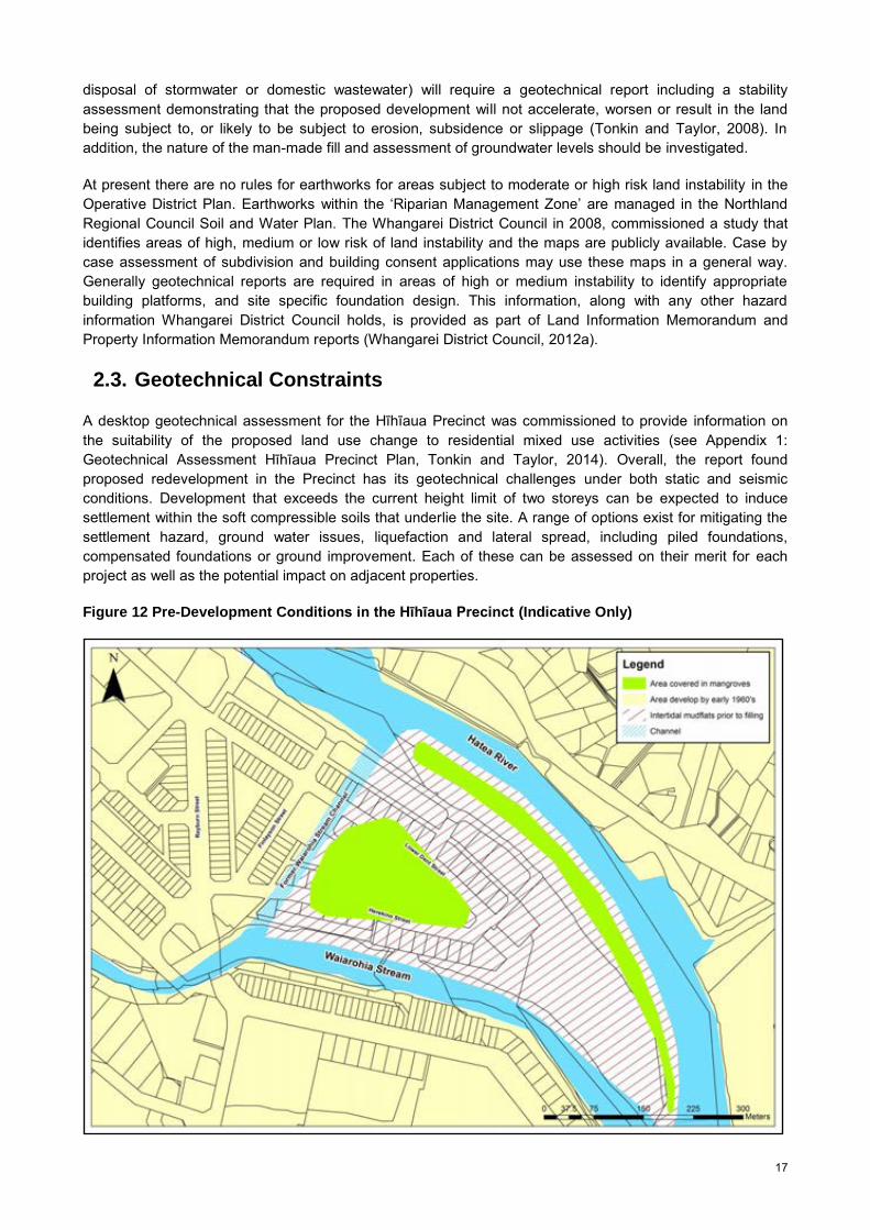
A desktop geotechnical assessment for the Hīhīaua Precinct was commissioned to provide information on the suitability of the proposed land use change to residential mixed use activities (see Appendix 1: Geotechnical Assessment Hīhīaua Precinct Plan, Tonkin and Taylor, 2014). Overall, the report found proposed redevelopment in the Precinct has its geotechnical challenges under both static and seismic conditions. Development that exceeds the current height limit of two storeys can be expected to induce settlement within the soft compressible soils that underlie the site. A range of options exist for mitigating the settlement hazard, ground water issues, liquefaction and lateral spread, including piled foundations, compensated foundations or ground improvement. Each of these can be assessed on their merit for each project as well as the potential impact on adjacent properties.
Figure 12 Pre-Development Conditions in the Hīhīaua Precinct (Indicative Only)
18
The Hīhīaua Peninsula was a low-lying to intertidal zone and prior to filling the area was covered in mangroves and intertidal mudflats (refer to Figure 12). The Hīhīaua Precinct is a largely artificial construct with the original low-lying to intertidal location having been initially built up in 1966 with some 2m of pumped dredge tailings (Tonkin and Taylor, 1970). Additional imported fill was placed over the dredge tailings during the late 1960s and early 1970s. Only some of this fill appears to have been engineered (Tonkin and Taylor, 1978). The final phase of the Precinct’s development was the progressive placement of temporary fill across individual development blocks as preload. The purpose of the preload fill was to induce consolidation within the underlying compressible soils prior to the construction of buildings (Tonkin and Taylor, 2014). Preloading has allowed the successful development of numerous one and two storey buildings since the 1970s.
A limited number of deep geotechnical investigations have been undertaken on the Peninsula since reclamation works were completed. The majority of these consist of boreholes undertaken by Tonkin and Taylor in 1970 and 1978, although other investigations including Cone Penetration Testing (CPT), shallow hand auger boreholes and Scala Penetrometer tests have been undertaken. Based on the available geotechnical data, the following generalised subsurface profile has been adopted for the Hīhīaua Peninsula:
Elevation (Chart Datum)1 Material Description
+5m to +3m Clay Fill +3m to +1m Soft clayey silt (dredge tailings) +1m to -1m Soft silt and clayey silt with beds of sand and gravel -1m to -8m Soft clay and clayey silt -8m to -11m Sand and gravel -11m to -16m Soft to firm clayey silt with sand beds -16m+ Dense sand and gravel with silt matrix (thickness unknown) Unknown Depth Northland Allochton and/or Kerikeri Volcanics
The geotechnical conditions of the Hīhīaua Precinct, being underlain by a thick sequence of soft and compressible sediments, make it challenging for future development. Under static conditions, dewatering, soft soil excavation and ground settlement risks can be mitigated with conventional engineering solutions. Under seismic conditions, there is potential for liquefaction and lateral spreading to occur. These hazards and their mitigation will require site investigation and assessment. Development in the Precinct can expect to face higher development costs due to these geotechnical constraints.
Firstly, settlement issues were mitigated during the original development by preloading the ground with temporary fill. The typical preload applied to enable one or two storey buildings was 24kpa (Tonkin and Taylor, 1981). New buildings higher than two storeys in the Precinct and/or modifying existing buildings with shallow-foundations whose weight exceeds the original preload level, can be expected to experience settlement. A new building that exceeds two storeys in height or buildings with high imposed floor loads will need to be designed to ensure settlement can be limited to within tolerable limits (usually 25mm).
A number of options are available to mitigate the settlement hazard, including piled foundations, compensated foundations, ground improvement and/or combination solutions. Each of these can be assessed on their merit for each project as well as the potential impact on adjacent properties. Refer to Table 2 below, outlining the various mitigation options.
Seismic liquefaction and lateral spread is typically a risk under longer return period earthquake loads, (say 1 in 500 year earthquake loading). In an earthquake, liquefaction and lateral spread will likely impose deformations and possibly tilting on structures situated in the Peninsula (Tonkin and Taylor 2014). Specific liquefaction analyses for the Precinct have not been undertaken as part of the assessment however, these
1 Elevations in the historic geotechnical reports are presented in terms of maritime Chart Datum rather than the more typical LINZ datum. This reflects the fact that the locality was effectively part of Whangarei Harbour at the time of development and survey works were undertaken by the Northland Harbour Board.

19
risks need to be taken into account for future development. This hazard and its mitigation would require site specific assessment and design for individual site(s) at their time of redevelopment.
Mitigation measures can either be in the form of: Soil strengthening (drainage, soil mixing, soil replacement, stone columns); Limiting the ability of material to move through the construction of a perimeter in ground retaining
wall between the Peninsula and the streams; or The isolation of buildings from the liquefiable zones through piled foundations, etc.
Table 2 Geotechnical Mitigation Measures
Mitigation Measure Explanation
Piled Foundations
Based on current geotechnical information, piles are likely to be in excess of 20m in length in order to reach a dense sand/gravel layer. Additional geotechnical investigations will be required in order to confirm both the lateral extent and thickness of this potential pile founding layer.
Piled structures are likely to be more resistant to the effects of liquefaction and lateral spreading, although some deformations could still occur depending on the design adopted, the magnitude of the seismic event and the depth of displacement.
Compensated Foundations
Compensated foundations, by including a basement level(s) within a structure’s design, can be an attractive alternative to piled foundations provided that constructability issues can be addressed.
The weight of the building can be balanced against the weight of the soil removed and any hydrostatic uplift forces. By balancing the forces so that there is no overall increase in imposed loads, settlement can be minimised or eliminated.
Compensated buildings will have to address liquefaction and lateral spreading risks.
Ground Improvement A range of ground improvement techniques are available through which the
compressibility and load carrying capacity of the upper soils can be improved. Possible ground improvement techniques that might be considered include soil mixing, reinforcement with driven timber poles and stone columns. The selection of one ground improvement technique over another will depend upon the specifics of the proposed building.
Most ground improvement techniques (except preloading and wick drains) also partially or completely mitigate the effects of liquefaction and possibly lateral spreading, although not necessarily to the specifics of the design seismic event.
Combination Solutions
Combination solutions depending upon the development being considered, settlement may be mitigated through a combination of two or more options e.g. a partially compensated foundation with a piled slab.
Lastly, the effects of climate change and sea level rise will have an affect on future development. Low-lying areas such as the Hīhīaua Peninsula are at particular risk of being affected by long-term sea level rise. The effects are not only elevated water levels along the coastal edge of the peninsula but also the associated increase in groundwater levels.
Land Information New Zealand gives Mean High Water Springs tide level at Whangarei as 3.12m above Chart Datum. With the ground level of the Peninsula being approximately 5m above Chart Datum, a 0.5m reduction in the current freeboard could be significant in terms of long-term development in this area. In addition, a 0.5m rise in sea level could potentially bring groundwater levels to within 0.5m to 1.0m of the current ground surface. Mitigation measures could include raising the level of land (by filling) or an increase in ground floor elevations. High groundwater is potentially an issue, particularly with respect to basement construction and long-term water tightness, however, its management is considered to be relatively routine.
The construction of basements or semi-basements in the soft sediments and relatively high groundwater tables is likely to be challenging, although still suitable for standard construction techniques. One significant hazard associated with the construction of basements in saturated, poorly consolidated soils is dewatering-

20
induced ground settlement which may adversely affect nearby buildings and infrastructure. Development(s) with basements or semi-basements are likely to require a higher than usual level of geotechnical design, construction supervision and mitigation planning as there is an elevated risk of excavations affecting neighbouring properties (Tonkin and Taylor, 2014).
In summary, redevelopment of the Hīhīaua Precinct has significant geotechnical challenges. Under static conditions, high groundwater, soft soil excavation and ground settlement risks associated with dewatering can be mitigated with conventional, although potentially more expensive solutions. These would require site-specific design. Seismic liquefaction and lateral spread is also a risk factor that will need to be considered when proposing development projects on the Peninsula. Seismic hazards and possible mitigation options would require site specific assessment and designs for redeveloped properties. Lastly, there are risks from sea level rise which need to be factored in to future development proposals. An increase in sea level rise could increase the potential for inundation or flooding in the Precinct and raise ground water levels. Future developments may need to consider increases in ground level (by filling) or an increase in ground floor elevations. Overall, redevelopment of the Precinct to residential/mixed use is possible but challenging. The greater the building height the more challenging it becomes. Two to three storeys, should be relatively straight forward whilst heights greater than this will be more complex and expensive.
2.4. Potentially Contaminated Land
New Zealand has a history of land contamination arising from past use, storage and disposal of chemicals utilised in industry, agriculture and horticulture. Activities within the district that cause or potentially cause contamination include landfills, petroleum-related uses, timber treatment, manufacture and use of pesticides, production of gas and coal products, historic mining, quarries and some agricultural/horticultural activities.
The National Environmental Standard (NES) for ‘Assessing and Managing Contaminants in Soil to Protect Human Health’ came into force on 1 January 2012. It puts in place a consistent set of national standards for assessing and managing contaminates in soil. The NES applies to any “piece of land” on which an activity or industry described in the current edition of the Hazardous Activities and Industries List (HAIL) is being undertaken, has been undertaken, or is more likely than not to have been undertaken (regulation 5(7) of the NES). Figure 13 highlights sites that may trigger the NES for Assessing and Managing Contaminants in Soil to Protect Human Health. A preliminary site investigation or obtaining up to date Council records is likely to be required for these sites. A preliminary site investigation report is required to be completed by a suitably qualified and experienced practitioner, and produced in accordance with the current edition of the Contaminated Land Management Guidelines No. 1 Reporting on Contaminated Sites in New Zealand (Ministry for the Environment, 2012).
Whangarei District Council has identified land likely to be captured as a HAIL activity through using district and regional council records. There are 68 HAIL sites in the Hīhīaua Precinct, shown in Figure 13. Preceding and current activities in the Precinct include activities such as printing companies, panel beaters, car repairs, glass manufacturing and dry cleaners among others. Identified contaminants include, for example, petroleum based products, lead sludges, resins, paint wastes, glues, solvents, heavy metals, strippers, dyes and perchloroethylene from dry cleaning activities. There is one verified (by the Northland Regional Council) asbestos site.
The role of the district council has traditionally related to the dissemination of information on contaminated sites via Land Information Memorandums (LIMs) and Project Information Memorandums (PIMs) once potentially contaminated sites have been identified by the regional council. Whangarei District Council records do not necessarily confirm land contamination, however, they give an indication the site may fit within regulation 5(7) of the NES. To establish whether or not a piece of land is described in regulation 5(7), the applicant has two options under regulation 6(2) and (3) to confirm the site status; using the most up-to-date information Council holds, or rely upon a preliminary site investigation report. If one of the methods confirms the NES applies, then the activity status for the activity (such as changing the use of the piece of land) will be determined. The activities are classed into the following activity status; permitted activities, controlled activities, restricted discretionary activities or discretionary activities.

21
Figure 13 Potentially Contaminated Land
There are inherent constraints when redeveloping land that is contaminated. These constraints come in the form of costs of remediating contaminated land, the cost of having land that is not suitable for re-development, or the potential cost to human life and the environment. Remediation will likely be needed for land changing land use to a sensitive activity, when reports indicate present contaminants are above acceptable limits for public health, or when contaminated facilities are retired.
2.5. Reverse Sensitivity Issues
Reverse sensitivity issues arise when different land uses, for example, residential and rural production activities occur in close proximity. Reverse sensitivity can also arise when sensitive activities such as residential uses are introduced to an environment where there are existing effects-intensive activities.
The Hīhīaua Precinct is made up of predominately light industrial and servicing activities. When introducing sensitive land uses such as residential activities, residents’ expectations and the effects of commercial/light industrial activities will need to be managed carefully. New, or expanding industries and activities, will need to be carefully assessed in the Precinct. In addition, stringent controls for noise, odour, parking, traffic movements and hours of operation can assist to mitigate reverse sensitivity issues. To safeguard existing industries and commercial activities, residents moving into the Precinct will need to be aware of existing operations and may need to enter a ‘no complaints’ covenant to ensure that residential development does not impact on the day to day commercial activities already existing there.
The Town Basin Environment and Business 2 Environment should be rezoned to ‘Residential Mixed Use’. The Mixed Use Environment will enable a compatible mix of residential and commercial activities. As the Precinct redevelops it is expected existing light industrial activities will relocate out of the Precinct to other light industrial zones.

22
Reverse sensitivity issues, particularly when introducing residential uses in existing commercial areas and introducing a ‘Residential Mixed Use Environment’ need to be considered when establishing District Plan objectives, policies and rules. If not managed well it has the potential to lead to conflict between activities. Activities conflicting with residential uses could include heavy industrial activities or light industrial activities because of hazardous substances, vehicle movements or noise/vibration generated by the activity. Requiring noise attenuation standards for apartments in mixed use areas, restricting traffic movement and delivery times for commercial activities and noise limits for different times in the day/week for example are provisions which will enable a greater range of compatible activities. Restricting hours of operation for potentially noisy activities may also need to be considered. In addition, resource consent conditions could be designed to ensure new activities in the Hīhīaua Precinct mitigates adverse effects and do not further compromise the amenity of the area.
2.6. Cultural/Historic Heritage
The Hīhīaua Precinct has a wealth of historical significance from both Maori and European settlement. This historic cultural heritage is special and unique to the Town Basin Environment and Hīhīaua Precinct and contributes to Whangarei’s sense of place.
2.6.1. Heritage Buildings, Sites and Objects
The Whangarei Operative District Plan contains objectives, policies and rules that seek to protect heritage buildings sites and objects (refer to Chapter 13 and Chapter 58 of the Whangarei Operative District Plan). There are 163 scheduled heritage buildings, sites or objects within the district that are recognised to have heritage value to the community, of which five are Group I listed (Whangarei District Council, 2007). A Group I listing is considered to be special and outstanding, whist Group II have heritage values, but to a lesser extent. There is one heritage building located within the Hīhīaua Precinct (refer to Figure 14 and Figure 15).
Figure 14 Heritage and Cultural Features in the Hīhīaua Precinct

23
Reyburn House is classified as a Group I Heritage Building (shown in Figure 15). It is the oldest existing settler’s home in Whangarei. Built between 1865 and 1875 on the Hatea River, the small cottage was refurbished into a larger villa with verandas (Northland Society of Arts, 2013). Since 1966, Northland Society of Arts has used the building as a studio, workshop, gallery and now museum.
Figure 15 Reyburn House
There are six rules in the Heritage Buildings, Sites and Objects Chapter of the Operative District Plan which detail the activity status of works affecting heritage buildings or requiring resource consent. The rules in the District Plan allow additions, alterations repairs and maintenance of heritage buildings, sites and objects provided that they do not detract from the original style and character of the building. For Group II listed buildings this applies to exterior work only. For Group I buildings, both exterior and interior work is controlled. The rules also control the construction of buildings on the same site, or on adjoining sites and relocation of heritage buildings and objects in the district.
2.6.2. Tangata Whenua
The Operative Whangarei District Plan contains objectives, policies and rules that seek to protect sites of significance to Maori from subdivision, land use activities, and development (refer to Chapter 7 - Tangata Whenua, Chapter 60 – Sites of Significance to Maori, and Subdivision Rules in Chapter 8). The Operative District Plan lists 86 sites of significance to Maori that are identified in Appendix 4 of the Operative Plan and shown on the Operative Planning Maps. In many cases, sites of significance to Maori can also be archaeological sites and may also be protected under the Historic Places Act 1993, or on the New Zealand Historic Places Trust Register. Cultural Impact Assessments and/or resource consent may be required for activities that disturb or modify sites or areas of significance to Maori.
Sites of significance to Maori or waahi tapu play an important role in determining the relationship of Maori to their environment. Waahi tapu are places that are sacred, significant or important and may be based on tangible or intangible values. This includes a wide range of sites and could include marae, burial places, battle fields, pa and village sites, springs, waka landing sites, travel routes or food gathering sites. Each site has a level of tapu associated with it depending on its significance.
There are no Maori ‘Sites of Significance’ identified in the Whangarei Operative District Plan, archaeological sites listed on the New Zealand Archaeological database, or land owned by Maori identified in Council rates data within the Precinct. However, the wider area has great significance to Maori and the area was occupied
24
by local Maori and used for fishing purposes. It was used as a landing place for canoes, a shellfish gathering ground, and a camping area used by Maori coming to town for Land Court sittings. A Pā was located on the Ōkara hills.
When changing the District Plan or initiating a plan change to implement the Hīhīaua Precinct Plan, Maori and relevant iwi/hapu groups will be consulted. Should any archaeological sites be discovered during land development, permission will need to be obtained from the Historic Places Trust to alter or destroy the site.
2.6.3. Cultural Features
The Hīhīaua Precinct features a number of cultural icons including the Heritage Trail connecting the Art Walk to the award-winning Waka and Wave Sculpture located near the point of the Hīhīaua Peninsula. The Heritage Trail/Art Walk was part of an integrated framework plan to help revitalise the Town Basin environment and form part of the Town Basin heritage and cultural precinct. The Heritage Trail is located along the Hatea River between Reyburn House Studios and the Riverbank Theatre and was designed to increase public use of open space areas, increase awareness, and celebrate local history and culture.
The Waka and Wave Sculpture is a ‘signature’ public sculpture and taonga located on the Hīhīaua Peninsula. The sculpture incorporates a spectacular ground-based cast stone-faced wakatete (or fishing waka) over 20m in length, symbolic of the migratory traditions of both Treaty partners, and incorporates monolithic stone wave forms in continuous suspension that transverse both the land and sea. Included within the form of the work is a stone ‘haka’ platform making Waka and Wave unique in that it allows for public interaction and thereby encourages the continued performance and celebration of our heritage and culture. Its location is particularly appropriate as it reflects the legendary Maori name for Whangarei –Te Renga Paraoa- a gathering place for whales, as the peninsula’s landform is reflective of a whale’s head. Another interpretation is that the harbour was a gathering place for chiefs.
2.6.4. Views/ View Shafts
Visually, Parihaka provides a striking natural backdrop to the Hīhīaua Precinct. The bush clad landscape is a valuable asset to the City and provides a natural and visual relief to the urban area. Parihaka assists define Whangarei City’s sense of place and provides legibility in the City. Parihaka holds strong cultural and historical values as it was the location of the largest defensible Pa site in New Zealand. The local chief, Iwitahi, had his Pa, Pihoi and papakainga on Parihaka above Te Ahipupurangi (Town Basin). Parihaka is identified as a ‘site of significance’ to Maori in the Operative District Plan.
View shafts provide visual linkages to significant natural, cultural or built features. Key view shafts for the City were identified in the Whangarei City Urban Character Assessment (Archifact Limited and Littoralis Landscape Architecture, 2005). Refer to Figure 16. Views and view shafts to Parihaka from the Hīhīaua Precinct via gaps within the built environment should be protected and enhanced wherever possible. This could be achieved through limiting the building height and protecting view shafts to maintain visual connections to Parihaka.
Also important are views and view shafts of the marine environment. The Hatea River and Waiarohia Stream surround the peninsula. Views to the marine environment and down the harbour towards the Lower Hatea River Bridge – Te Matau ā Pohe, help define the character and sense of place of the peninsula. In addition, views of the marinas, boatsheds, yachts, along with views across to Pohe Island are all important and should be protected and enhanced wherever possible. Lastly, retaining, providing and enhancing visual linkages to open space is important, both in terms of facilitating legibility, orientation for the viewer, or by introducing glimpses of ‘greeness’ into the urban environment.

25
Figure 16 View Shafts from the Central City
Source: Archifact, Littoralis and Landscape Architecture, 2005.
2.7. Natural Heritage
2.7.1. Biodiversity
Whangarei City is surrounded with areas of significant natural habitat particularly in the Parihaka Forest (Q07/018) and Pukenui Forest (Q07/022). Numbers refer to survey references in the Protected Natural Areas Programme (PNAP) reports produced by the Department of Conservation. Parihaka Forest is an important habitat area within the urban context and Pukenui Forest is the largest remaining contiguous area of forest left in the Whangarei Ecological District and the catchment area for the Whau Valley Dam. These environments are important ecological areas as they provide habitat for threatened and regionally significant species and provide essential ecological services to Whangarei City (Whangarei District Council, 2010a).
Urban biodiversity is an important element to enhancing urban amenity, sense of place and providing ecological services. Providing habitat for biodiversity in urban areas is also important in providing ‘stepping stones’ and connections with habitats outside of urban areas. Riparian areas can be effective areas to restore and enhance these habitats. Restoring waterways and promoting riparian vegetation in these areas will increase biodiversity values and assist to restore connections between habitats. Riparian vegetation contributes to stream health by acting as a buffer from contaminant runoff, and decreasing water temperatures, allowing more oxygen to be available to in-stream communities (Whangarei District Council, 2012b).
2.7.2. Blue/Green Network
The waterways through the city act as ‘blue/green corridors’ and assist fauna to move through the urban environment. Re-vegetating areas such as along riparian reserves or strips will provide opportunities for establishing ecological corridors and are an important mechanism for biodiversity protection and enhancement. The Blue/Green Network will provide multi-use benefits including ecological benefits, stormwater benefits and recreational benefits.
26
In Whangarei City there are examples of urban waterways that have retained natural habitat and biodiversity values such as Cafler Park and along Western Hills Drive. Restoring and replanting vegetation along other waterways will assist to create a route or ecological corridor for fauna to move between discrete areas of habitat. Restoration of riparian areas will also contribute to flood retention and mitigation, stormwater/wastewater/sediment filtration, provide recreational opportunities and enhance sense of place and amenity values. It can also be used to connect the walkway and cycleway network in the urban area.
2.7.3. Landscape
The Hīhīaua Precinct is generally regarded as an urban landscape. The Pukenui Forest and Parihaka form a dominant native bush backdrop for the City. The landscape of Parihaka holds strong cultural values and is an area of high natural character. Vegetation, trees and landscaping should be encouraged on private and public land in the Hīhīaua Precinct to improve the urban landscape and amenity values. The Hatea River and Waiarohia Stream and views down the Harbour and across to Pohe Island area also important landscape features surrounding the Hīhīaua Peninsula. These features need to be protected and enhanced wherever possible. The riparian edges, including mangrove vegetation where appropriate, need to be protected to enhance the marine character and sense of place of the Hīhīaua Precinct.
2.7.4. Heritage Trees
The Operative District Plan contains a list of protected heritage trees (in Appendix 2 of the Operative District Plan). These trees require resource consent for any removal, destruction or trimming, which does not fall within the permitted activities in accordance with Rule 59.2.1 of the Operative District Plan.
Activities within the drip line of heritage trees are also controlled by rules in the Plan. Any tree greater than 6.0m in height or with a girth (measured 500mm above the ground) greater than 600mm located within a road reserve or reserve administered by Council is classified as a Heritage Tree.
2.7.5. Mangroves
Prior to European settlement, mangrove flats covered much of the central area of Whangarei. Following decades of extensive reclamations around the CBD and old port area, many of the mangroves that once covered the shallow margins of the upper Hatea River are gone (Northland Regional Council, and Whangarei District Council, 2012).
Mangroves (Avicenna marina) are the most visible and high profile habitat type, covering a large area of the harbour margins. Mangroves typically locate in the intertidal margins of low-energy coastal and estuarine environments. The Hatea River banks are intermittently lined with mangroves. Mangroves provide a number of ecological benefits such as reducing sedimentation, erosion control and shoreline stability, provide a habitat for some bird species and juvenile species and provide an important food source (Northland Regional Council, 2013). While they have benefits, some people see mangroves as a nuisance. There is the view, particularly in some coastal areas, that mangroves reduce amenity and recreation values associated with estuaries and the coast.
Mangroves are protected in Northland. This means they cannot be removed, pruned or trimmed without Northland Regional Council consent (in accordance with provisions in the Regional Coastal Plan). Whangarei District Council obtained consent in March 2013, to remove mangroves in selected areas along the Hatea River to protect existing seawalls and open up vistas along the water’s edge. The consent included removing and pruning mangroves in the Hīhīaua Precinct such as near the Waka and Wave Sculpture and adjacent to the Art Walk. Although mangroves have an ecological purpose in intertidal ecosystems, in some locations sense of place and views to the water and associated marine elements can be more valued.

27
2.7.6. Whangarei Harbour
The Whangarei Harbour is a popular destination for domestic and overseas sailors, and is often the home of a number of international users. There are 354 moorings and 432 marine berths in the Whangarei Harbour. The majority of these are found in the Hatea River. The Whangarei Marina berths 280. There are also a small number of private jetties used for permanent mooring. Most of these jetties are located in the Waiarohia Canal (the lower reach of the Waiarohia Stream) (Northland Regional Council and Whangarei District Council, 2012).
The Whangarei Harbour (Q07/058) is a wildlife refuge of international importance, which contains salt marsh, mangroves, wetlands, intertidal and sub tidal habitats (Whangarei District Council, 2010a). The mangrove forests and coastal forests bordering the harbour act as important buffers from land use activities. In addition, the Whangarei Harbour is an important habitat and breeding site for wading birds, including the nationally critical Fairy Tern and White Heron.
Figure 17 Town Basin Marina
2.7.7. Water Quality
Waterways are important in Central Whangarei, many streams flow through the city to the Whangarei Harbour. The Hatea, Waiarohia, Kirikiri, Raumanga and Limeburners Creek sub-catchments drain to the Hatea River or Waiarohia Stream. These sub-catchments cover a range of substrates including; pasture, indigenous vegetation, forestry, urban residential, industrial and commercial areas. Water quality in streams is affected by silt, sediment, contaminants and polluted substances particularly during heavy rain events when wastewater runoff from impervious surfaces such as roads, roofs and pavements enters waterways. Riparian improvement including planting along waterways can improve the water quality of the streams by capturing silt, pollution and assist with flood protection.
The upper harbour including the Hatea River has reduced water quality and remains degraded. This can impact adversely on a number of its uses and values. Over the past several decades, considerable effort has been spent on reducing discharges of contaminants to improve the quality of water in the Harbour including upgrades to the Whangarei Wastewater Treatment Plant (WWTP), the Okara Park and Hatea wastewater pump stations (Northland Regional Council, and Whangarei District Council, 2012).
Evidence from the Northland Regional Council shows while long term water quality monitoring results indicate that potential public health risks are higher in the Hatea River arm compared to other parts of the upper harbour, recent research has suggested that the risks may be lower than previously thought. Water
28
quality monitoring results (faecal coliform levels) for the period 1986-2012 found a reduction in bacteria level at several sites in the Hatea River arm close to Limeburners Creek between 1989 and 1990. This improvement was linked to an upgrade of the Whangarei Waste Treatment Plant during that time. However, since then there has been no statistically significant reduction in bacteria levels, although on-going monitoring is expected to show a reduction in loads from the WWTP, Okara Park and Hatea pump stations due to recent upgrades (Northland Regional Council, and Whangarei District Council, 2012).
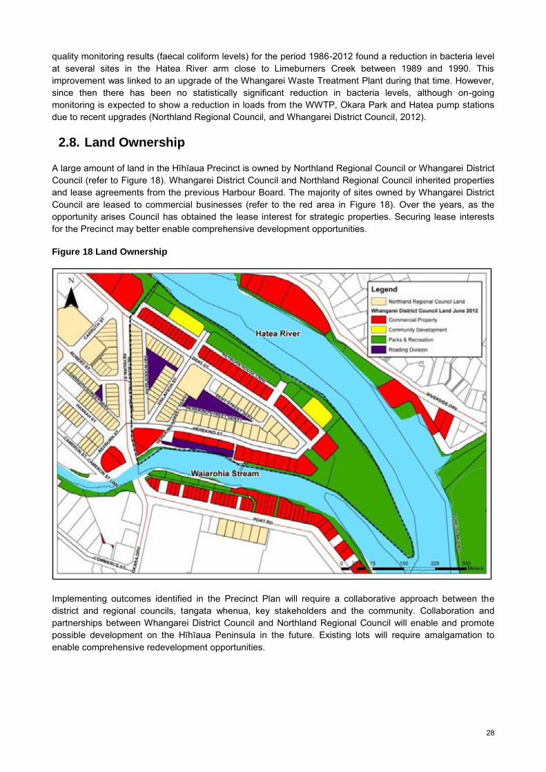
2.8. Land Ownership
A large amount of land in the Hīhīaua Precinct is owned by Northland Regional Council or Whangarei District Council (refer to Figure 18). Whangarei District Council and Northland Regional Council inherited properties and lease agreements from the previous Harbour Board. The majority of sites owned by Whangarei District Council are leased to commercial businesses (refer to the red area in Figure 18). Over the years, as the opportunity arises Council has obtained the lease interest for strategic properties. Securing lease interests for the Precinct may better enable comprehensive development opportunities.
Figure 18 Land Ownership
Implementing outcomes identified in the Precinct Plan will require a collaborative approach between the district and regional councils, tangata whenua, key stakeholders and the community. Collaboration and partnerships between Whangarei District Council and Northland Regional Council will enable and promote possible development on the Hīhīaua Peninsula in the future. Existing lots will require amalgamation to enable comprehensive redevelopment opportunities.

29
3. Part C: Infrastructure Constraints Analysis
In summary, there are no infrastructure or utility constraints in the Hīhīaua Precinct that can not be addressed over the medium term.
3.1. Core Infrastructure
Transport, solid waste, wastewater, stormwater and parks along with adequate and reliable water supply is essential infrastructure which should be provided in a proactive and efficient manner that precedes development rather than reacting to development pressures. Four residential capacity development scenarios for the Hīhīaua Precinct were developed to analyse capacity and used to undertake a preliminary assessment of infrastructure requirements, constraints and potential costs (refer to Section 5.2). Hard infrastructure analysis included transport, solid waste, wastewater, water, stormwater disposal, other utilities, and parks and reserves.
3.1.1. Transport Infrastructure
Whangarei has a widely dispersed settlement pattern which requires roading infrastructure to support it. Private cars are heavily replied on for most of our personal travel and on road vehicles for most freight movements. As a consequence Central Whangarei was faced with capacity and congestion issues particularly in the CBD and along State Highway 1 as it passes through the City. The network was operating beyond design capacity with the roading network catering for approximately 125,000 vehicles per day.
Recent major roading projects and associated upgrades have improved congestion within the inner Whangarei. Major projects and upgrades include the Kamo Bypass (Stage 2), Spedding Road extension, Porowini Avenue extension and the Lower Hater River Bridge – Te Matau ā Pohe which opened in July 2013 (refer to Figure 19). Further State Highway 1 upgrades will assist to improve traffic movement within and out of the City. A modal shift to alterative transport modes will also assist to alleviate traffic issues.
Figure 19 Te Matau ā Pohe Bridge
Source: Mc Kay, 2013.
30
The Hīhīaua Precinct has approximately 125 businesses and 17 residential dwellings. It is estimated there are approximately 813 employees working in the Precinct. The local roads serving this area are Reyburn Street, Lower Dent Street, Finlayson Street, and Herekino Street, with three service lanes and associated internal parking areas.
A desk-top study analysing traffic flows suggests Scenarios 1, 2 and 3 may have similar traffic movements to existing commercial traffic movements. No modelling would be required, if it can be demonstrated that there is not a significant increase in traffic volumes. However, if there is an increase say for example 500 additional movements, then traffic modelling would be required. Scenario 4 will result in a population increase of approximately 3,000 people. Town Basin amenities and proposed developments such as the Hīhīaua Cultural Centre, highlights a need to address any arising issues regarding the effect additional development would have on the existing roading network and parking. It is recommended that should Scenario 4 eventuate, then traffic modelling would be required.
It is recommended, the Plan Change for the Hīhīaua Precinct;
Includes provisions that require traffic modelling to be undertaken for larger redevelopment proposals are included.
Trigger points in the network are identified through techniques such as traffic count data or traffic movement thresholds to indicate when upgrades would be required for safety and traffic efficiencies.
Look into revising parking provisions or developing a guideline for medium/high residential density housing and mixed use activities.
3.1.2. Solid Waste
Whangarei City is serviced by weekly household rubbish, recycling collection and a monthly kerbside paper collection. Commercial premises are serviced three times a week. Motels, private rest homes and camping grounds are serviced twice a week. The waste disposal facility is located at Puwera, Portland. Contaminated goods or hazardous substances are transported to Redvale, Auckland.
At present commercial areas within Whangarei City are not serviced with red Whangarei District Council recycling bins. Commercial and residential activities located within the City manage their own recycling. It is envisaged that the existing solid waste collection and disposal system will be able to accommodate the potential land use changes under the four development scenarios outlined. However, consideration for residential recycling such as a shared recycling facility for residents and the location of solid waste collection will need to be considered at the design stage of development.
3.1.3. Wastewater
Whangarei City is served by a sewerage reticulation system which is connected to the main Whangarei Wastewater Treatment Plant at Kioreroa Road. Wastewater from future dwellings or development will discharge to the existing sewers within the Hīhīaua Precinct to the treatment plant.
It is expected the Hīhīaua Precinct will have a relatively small contribution to an increase in wastewater flow from the area. Scenario 1 and Scenario 2 will require no upgrade whereas; Scenarios 3 and 4 will require upgrading. Scenario 3 anticipates a population increase of approximately 40%. An estimated cost to upgrade the gravity sewer is $300,000. This includes upgrading 150m of 150mm diameter wastewater pipes to 300mm and approximately 50m of 225mm to 375mm. Scenario 4 has the highest population increase with an increase of about 330%. Approximately $500,000 may be required to upgrade the gravity sewer which would include upgrading 180m of 150mm diameter wastewater pipes to 300mm and 160m of 225mm to 375mm, and $200,000 to upgrade the pump station to Robert Street.
In general, the local reticulation system in the Hīhīaua Precinct has capacity to cope with the proposed land use changes. The rising main is under loaded at present, therefore has sufficient capacity to cope with the
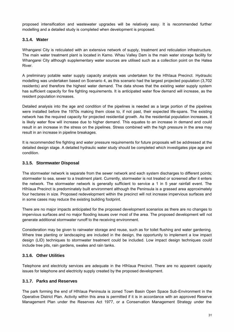
31
proposed intensification and wastewater upgrades will be relatively easy. It is recommended further modelling and a detailed study is completed when development is proposed.
3.1.4. Water
Whangarei City is reticulated with an extensive network of supply, treatment and reticulation infrastructure. The main water treatment plant is located in Kamo. Whau Valley Dam is the main water storage facility for Whangarei City although supplementary water sources are utilised such as a collection point on the Hatea River.
A preliminary potable water supply capacity analysis was undertaken for the Hīhīaua Precinct. Hydraulic modelling was undertaken based on Scenario 4, as this scenario had the largest projected population (3,702 residents) and therefore the highest water demand. The data shows that the existing water supply system has sufficient capacity for fire fighting requirements. It is anticipated water flow demand will increase, as the resident population increases.
Detailed analysis into the age and condition of the pipelines is needed as a large portion of the pipelines were installed before the 1970s making them close to, if not past, their expected life-spans. The existing network has the required capacity for projected residential growth. As the residential population increases, it is likely water flow will increase due to higher demand. This equates to an increase in demand and could result in an increase in the stress on the pipelines. Stress combined with the high pressure in the area may result in an increase in pipeline breakages.
It is recommended fire fighting and water pressure requirements for future proposals will be addressed at the detailed design stage. A detailed hydraulic water study should be completed which investigates pipe age and condition.
3.1.5. Stormwater Disposal
The stormwater network is separate from the sewer network and each system discharges to different points; stormwater to sea, sewer to a treatment plant. Currently, stormwater is not treated or screened after it enters the network. The stormwater network is generally sufficient to service a 1 in 5 year rainfall event. The Hīhīaua Precinct is predominately built environment although the Peninsula is a grassed area approximately four hectares in size. Proposed redevelopment within the precinct will not increase impervious surfaces and in some cases may reduce the existing building footprint.
There are no major impacts anticipated for the proposed development scenarios as there are no changes to impervious surfaces and no major flooding issues over most of the area. The proposed development will not generate additional stormwater runoff to the receiving environment.
Consideration may be given to rainwater storage and reuse, such as for toilet flushing and water gardening. Where tree planting or landscaping are included in the design, the opportunity to implement a low impact design (LID) techniques to stormwater treatment could be included. Low impact design techniques could include tree pits, rain gardens, swales and rain tanks.
3.1.6. Other Utilities
Telephone and electricity services are adequate in the Hīhīaua Precinct. There are no apparent capacity issues for telephone and electricity supply created by the proposed development.
3.1.7. Parks and Reserves
The park forming the end of Hīhīaua Peninsula is zoned Town Basin Open Space Sub-Environment in the Operative District Plan. Activity within this area is permitted if it is in accordance with an approved Reserve Management Plan under the Reserves Act 1977, or a Conservation Management Strategy under the

32
Conservation Act 1987. There is no approved Reserve Management Plan under the Reserves Act, and preparation would require classifying the land as a reserve.
Residential intensification in the Precinct would result in increased demand for readily accessible recreation space for residents. Neighbourhood reserves provide local recreation space for activities such as walking and dog walking, ball activities, ‘unstructured playing’ and learner cycling for younger children, jogging, and socialising for all ages.
Figure 20 Hatea River Heritage Trail/Walkway
The New Zealand Recreation Association (NZRA) recommends the following provision of Neighbourhood Reserves:
1.0-1.75 hectares per 1,000 residents. Located within a ten minute walk of residents, or distance of approximately 500 metres. Area of 3,000 m2 or larger.
At the lower end of intensification for all sub-precincts, Scenario 1 could provide for approximately 600 residents. Using NZRA recommendations for neighbourhood reserve provision, 0.6-1.05 hectares would be required to provide sufficient area for recreation opportunities for residents. The existing area of open space could include areas suitable for neighbourhood reserve use, and this would complement existing use of this area as a destination park.
At the higher end of intensification, Scenario 4 anticipates 3,702 residents. This would require 3.7 to 6.4 hectares of neighbourhood reserve/open space. The degree of use by residents could undermine the values of the open space as a destination playground, and ideally additional open space should be provided to meet the needs of local residents.

33
The combined area of the two titles at the end of Hīhīaua Peninsula is approximately three hectares. With additional areas of open space bordering the Hatea River, the area would be approximately four hectares although this area is also used for civic purposes, such as a Heritage Walk and Art Trail.
At present, public access along the riparian area along the Waiarohia Stream is constrained due to the land ownership patterns and buildings impeding access along the esplanade area. As redevelopment occurs, there is an opportunity to provide access along the esplanade area and connect open space areas.
It is recommended neighbourhood open space based on the New Zealand Recreation Association standards is provided in the Hīhīaua Precinct should the resident population increase above 1,800 people.
3.2. Community Infrastructure
Social infrastructure includes health care, education, emergency services, civic amenities, arts, cultural facilities, recreation and entertainment. In order to ensure balanced and sustainable communities we must provide an appealing and well resourced social infrastructure to attract and retain all age cohorts. Soft infrastructure analysis includes heath care, education, emergency services, and community facilities.
3.2.1. Health Care
Whangarei City is well served by health facilities, including one private hospital (Kensington Hospital) and the public hospital for Northland is located in Maunu, approximately three kilometres from the Hīhīaua Precinct. In the Central Whangarei area there are approximately 13 medical centres and six chemists. Within the Hīhīaua Precinct there is one medical centre and one dentist located on Lower Dent Street.
Health care facilities to service the Hīhīaua Precinct appear adequate over the medium term. Should Scenarios 3 or 4 eventuate, additional facilities in the Hīhīaua Precinct may be required.
3.2.2. Education
Whangarei City plays a crucial role in primary, secondary and tertiary education in the Whangarei District. There are ten public and private schools found within Whangarei City. These include: Bloomfield Special School, Christian Renewal School, Morningside Primary School, St Francis Xavier School (primary), Te Kura O Otangarei, Whangarei Boys High School, Whangarei Girls High School, Whangarei Intermediate School, Whangarei Primary School, and Whau Valley Primary School. School deciles range from 1-6.
The University of Auckland’s Tai Tokerau campus was established in Whangarei in 1992. It is the site for teacher education programmes offered by the University. Also, North Tec provides a number of trades-related programmes and recently opened a Future Trades campus based in Whangarei’s industrial centre.
Draft projections from the Ministry of Education indicate there is sufficient capacity to cope with the predicted increase in population over the next 20 years. However, due to popularity of particular schools and population growth in certain areas, some schools are close to, or exceeding their allocated capacity. A number have introduced zoning schemes to prevent overcrowding, while other schools are well below capacity.
Residential re-development on the Hīhīaua Precinct should be able to be accommodated by existing educational facilities. Should development approach levels under Scenario 3 or 4, an additional local pre-school facility may be required. Scenario 4 may also require a school bus service.
3.2.3. Emergency Services
The main St. John ambulance station is based in Whangarei City, and there are currently 23 (FTE) ambulance officers and 12 volunteer ambulance officers stationed here. The Northland Emergency Services Trust also owns and operates two rescue helicopters which are dispatched via the St. John communication

34
centre in Kensington and crewed by two advanced paramedics (Whangarei District Council, 2010a). The Northland Emergency Services Trust announced in September 2013 that St John Ambulance service and emergency helicopter in Kensington will permanently move to Whangarei Airport at Onerahi, over the next 10 years. The Onerahi Airport is approximately eight kilometres from the Hīhīaua Precinct.
The Whangarei Central Police Station is located in Whangarei City on the corner of Cameron Street and Walton Street. The new Police Station was completed in 2009. It is likely the facility will be adequate over the medium to longer term, however staffing of both police officers and support staff as the population grows may increase to reflect population growth.
The main fire station for the district is located on Bank Street in Central Whangarei. The facility and staffing of both fire fighters and support staff will likely require expanding as the population in the district grows. Re-development of the Hīhīaua Precinct should be able to be accommodated by existing emergency services.
3.2.4. Community Facilities
Whangarei City has a number of arts, cultural and civic amenities including museums, a public library, a cinema and art galleries. The ‘Arts, Culture and Heritage Policy’ 2009, identifies the Town Basin as a ‘heritage and culture experience precinct’. The Town Basin has a number of arts and culture facilities such as the Clapham’s Clock Museum, Whangarei Art Museum Te Manawa Toi and art galleries for example, Burning Issues Gallery workshop, McClelland galleries, The Bach, Reyburn House Art Gallery, operated by Northland Society of Arts Inc and the Whangarei Theatre Company located along Reyburn House Lane.
Figure 21 Clapham’s Clock Museum
Community and district facilities within close proximity to the Hīhīaua Precinct include the Whangarei Aquatic Centre and Northland Events Centre (Toll Stadium). The loop walkway around the Hatea River will be completed by September 2014. It will connect existing and proposed facilities such as Pohe Island sport facilities, the Town Basin, and the Hīhīaua Maori Cultural Centre on the Hīhīaua Peninsula. Overall, the Hīhīaua Precinct is well served by community facilities and amenities.
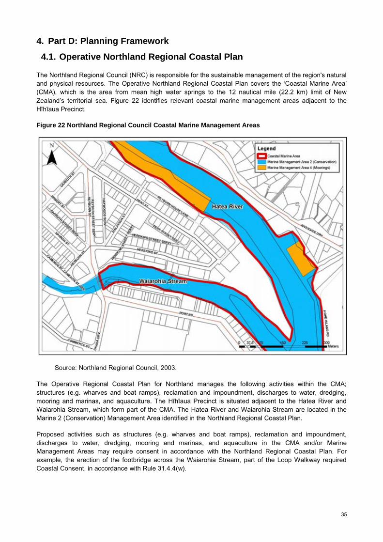
35
4. Part D: Planning Framework
4.1. Operative Northland Regional Coastal Plan
The Northland Regional Council (NRC) is responsible for the sustainable management of the region's natural and physical resources. The Operative Northland Regional Coastal Plan covers the ‘Coastal Marine Area’ (CMA), which is the area from mean high water springs to the 12 nautical mile (22.2 km) limit of New Zealand’s territorial sea. Figure 22 identifies relevant coastal marine management areas adjacent to the Hīhīaua Precinct.
Figure 22 Northland Regional Council Coastal Marine Management Areas
Source: Northland Regional Council, 2003.
The Operative Regional Coastal Plan for Northland manages the following activities within the CMA; structures (e.g. wharves and boat ramps), reclamation and impoundment, discharges to water, dredging, mooring and marinas, and aquaculture. The Hīhīaua Precinct is situated adjacent to the Hatea River and Waiarohia Stream, which form part of the CMA. The Hatea River and Waiarohia Stream are located in the Marine 2 (Conservation) Management Area identified in the Northland Regional Coastal Plan.
Proposed activities such as structures (e.g. wharves and boat ramps), reclamation and impoundment, discharges to water, dredging, mooring and marinas, and aquaculture in the CMA and/or Marine Management Areas may require consent in accordance with the Northland Regional Coastal Plan. For example, the erection of the footbridge across the Waiarohia Stream, part of the Loop Walkway required Coastal Consent, in accordance with Rule 31.4.4(w).

36
4.2. Operative Northland Water and Soil Plan
The Operative Regional Water and Soil Plan for Northland covers the effects of land use activities on water and soil in Northland above the line of mean high water springs. The Operative Water and Soil Plan for Northland manages activities involving discharges, taking or use of water, vegetation clearance, earthworks and activities within the Riparian Management Zone along rivers, lakes and the CMA, among other activities. Activities with minor effects do not require resource consent while others do, or are prohibited. Figure 23 shows the riparian management zone and coastal marine area.
Figure 23 Relationship Between the Riparian Management Zone and Coastal Marine Area
Source: Northland Regional Council, 2004.
Proposed activities such as discharges, taking or use of water, vegetation clearance, earthworks and activities within the Riparian Management Zone along rivers, lakes and the CMA may require consent in accordance with the Northland Water and Soil Plan.
4.3. Whangarei District Growth Strategy: Sustainable Futures 30/50
Whangarei District Council has prepared a long term Sub-Regional Growth Strategy to guide development in the district into the future. The Whangarei District Growth Strategy (2010) identifies economic drivers of growth, constraints and opportunities, and outlines infrastructural requirements for the district to meet its development needs over a 30-50 year timeframe. The Growth Strategy is based upon sustainability and integrated planning principles and provides an over-arching framework for development of the suite of planning documents and asset management plans formulated under the Resource Management Act and Local Government Act. These include the Long Term Plan, Annual Plan, Asset Management Plans, District Plan, various strategies, concept plans and structure plans.
The preferred future development path for Whangarei District identified in the Growth Strategy is a five tier settlement pattern with Whangarei City as the primary district and regional urban centre with a strong and enduring CBD. In Central Whangarei, there is limited potential for population growth with green-field development. To accommodate future population growth a range of approaches including brown-field redevelopment including business land redevelopment, residential intensification in appropriate areas, and mixed use development, particularly around the CBD/Town Basin and old port area is required. Given the projected number of people over the age of 65, demand is likely to increase for smaller, easily maintained lots or for residential village type accommodation. The Growth Strategy also envisages an increased demand for apartment style living in locations with high amenity, especially around Whangarei Harbour and/or close to green spaces.

37
The Growth Strategy encourages mixed use development which may be as large as an entire precinct or as small as a single unit that contains both living and work spaces. A mixed use development is one that contains non-residential (commercial, community, recreational or institutional) spaces, as well as residential ones. Mixed use development has the potential to improve the vitality and attractiveness of town and city centres over single use development.
The Growth Strategy promotes strong sense of place and place-making in the district. This includes historic and cultural heritage, natural heritage and landscape, land uses, gathering places and focal points, views and gateways, and the built environment encompassing such aspects as local character and amenity, neighbourhood identity, and urban design. Developing a strong sense of place, through good urban design incorporating those values (both natural and historic/cultural) that currently exist, will enhance the district and its varied settlements as places to live, work and play. A sense of place also serves to attract visitors and tourists thereby contributing in economic terms to employment and social development.
Arts, cultural and creative industries play an important role in creating vibrant, diverse and stimulating communities for residents and visitors alike. Whangarei has considerable potential to enhance its arts, culture and civic amenities based around cultural precincts or hubs. The Growth Strategy identifies the Town Basin area as having a coherent ‘sense of place’ and reinforces the Town Basin as a ‘heritage and culture experience precinct’. The Growth Strategy identifies the Town Basin as a cultural and leisure cluster with Clapham’s Clock Museum and Reyburn House at its centre. Arts and heritage activities including the potential redevelopment of the old Northland Regional Council Harbour Board building, and the Hīhīaua Maori Cultural Centre on the Hīhīaua Peninsula will be incorporated into future planning initiatives for Whangarei City. This will ensure Whangarei City develops as the regional arts, recreation and cultural hub for Northland.
At present Whangarei has a limited weekend and night time economy. The Growth Strategy recognises opportunities for increased socially inclusive leisure and evening/late night/weekend uses such as cafes, restaurants, bars, entertainment places, music venues and street markets in Central Whangarei and the Town Basin. A four star hotel and conference centre in the Town Basin could invigorate the weekend and night time economy in Whangarei. The Strategy also identifies revitalisation of the CBD and associated business areas as the most pressing issue. Revitalisation includes improvements to pedestrian connectivity around much of the area, but especially between the CBD and Town Basin.
The Growth Strategy promotes streams flowing through the City to act as ‘green/blue’ corridors to improve water quality and biodiversity. There is considerable potential to establish green/blue corridors along urban waterways such as the Hater River, Waiarohia, Raumanga, Kirikiri Streams and Limeburners Creek to create a network of blue/green corridors together with existing and extended open space in Whangarei City. A strategic Blue/Green Network will assist to improve ecological connections, enhance biodiversity values, mitigate flooding risk and provide an attractive pedestrian and cycle network. Blue/green corridors contribute to the amenity, ecological, social and cultural values of the City and to its sense of place, as a water-based settlement.
4.4. Whangarei Urban Growth Strategy
The Whangarei Urban Growth Strategy (2003) was developed to provide a 20 year strategic direction to manage urban growth in the district. The aim of developing the Urban Growth Strategy was to better understand the issues related to growth, in and around the urban area of Whangarei. The document sets out the vision for the urban area of Whangarei, the philosophy for growth, and 16 key issues relating to urban growth that need to be addressed in order to achieve the vision for Whangarei City. The Urban Growth Strategy vision for Whangarei is ‘to be an accessible green city, where people can live, work and shop in safe and clean surrounds, where art and culture are celebrated, and leisure opportunities abound’ (Whangarei District Council, 2003).
The Hīhīaua Precinct is located in the outer CBD, according to the Urban Growth Strategy (refer to Figure 24). The Urban Growth Strategy adopts the growth philosophy of a core CBD with a strong centre supported

38
by an outer CBD. The inner CBD and outer CBD provide a hub for retailing, business, commerce activities for the district and region. The vision of the Urban Growth Strategy is to promote Whangarei City as a strong focal point, and provide a variety of lifestyle options in the district including central city apartment living, attractive suburbs, rural residential and coastal lifestyle choices.
Figure 24 Urban Growth Strategy Issues and Options Map
Source: Whangarei District Council, 2003.
Key issues include reverse sensitivity, sporadic commercial development, absence of forward planning, pressure on the roading network, public transport including cycling and walking, infrastructure services, protecting important ecological systems, provision and access to open space and participation of tangata whenua in the planning process. Issues and options for Central Whangarei are illustrated in Figure 24. Objectives, policies and methods were developed to address the issues. Five structure plans have been developed as a result of the Urban Growth Strategy, but none for Central Whangarei.
Issues for the City Centre/ City Port raised in consultation include; provision of parking facilities, traffic safety and efficient, provision of pedestrian and cycle access around the City, negative perception of personal safety, especially at night, need for architectural design standards to preserve cityscape, controlling effects of industrial development, adequate provision, and management of effects of commercial development, adequate provision for residential development, consolidation of the City centre, provision of public transport and redevelopment of the City Port area.
4.5. 20/20 Plus Whangarei CBD Development Guide
The 20/20 Plus Whangarei CBD Development Guide is a central city development plan, founded on a ‘precinct approach’ (Whangarei District Council, Isthmus Group, Littoralis Landscape Architecture, and Traffic Design Group, 2006). The Guide provides a co-ordinated approach for the larger CBD area. It creates a conceptual framework based on a series of six pedestrian scale character precincts, each with at least one catalyst project site for development (refer to Figure 25). The six precincts proposed within the CBD area include Form North/Gateway, City Core, Town Basin, Waiarohia District, Marine Village and Rail side/Okara

39
Harbourside. The Town Basin Precinct was developed in greater detail to illustrate how each area within the Precinct could be further explored. Four options for the Town Basin were identified. Options include passive green space; iconic museums; conference facility and canal waterfront.
Figure 25 Central Business District Precinct Plan
Source: Whangarei District Council et al, 2006.
20/20 Plus proposes the introduction of inner city living in the ‘marine village’ precinct. The document envisions the marine village themed precinct with residential living to accommodate a growing population (refer to Figure 25 and Figure 26).
The Development Guide proposes to make use of the extensive water edge and scale of the existing light industrial sheds. Marine industries will be encouraged together with a mixture of new residential town house development, a scattering of artists’ studios, galleries and shops. The document proposes high and medium density residential living within the inner city. These are roughly calculated as 50 m2 per person or 100m2 per apartment for high density residential living and 100m2 per person for a terrace type apartment, medium residential living.
The CBD Development Guide envisions a green necklace concept, adopted after the ‘Boston Emerald Necklace’ to provide continuous public pedestrian access along the rivers’ edges connecting the Harbour back to the surrounding hills. It is envisioned the rivers edges will feature pathways, boardwalks and redeveloped parks with enhanced riparian planting.
The Whangarei CBD Development Guide identifies existing and future connections including major vehicle routes, bus routes, waterways, cycling and walking tracks. The Guide proposes cycle ways and walkways along the Hatea River and Waiarohia Stream. The proposed central bus circuit route is along Reyburn Street and it is envisioned Reyburn Street will continue to function as an Arterial Road. The proposed four km central bus circuit loop, would provide public transport opportunities every 15-20 minutes within the CBD.

40
Figure 26 20/20 Plus-Issues and Opportunities Map
Source: Whangarei District Council et al, 2006.
4.6. Whangarei 20/20 Momentum
The Whangarei 20/20 Momentum Plan (2012) brings together a number of projects from the current Long Term Plan, private projects and possible future projects. The document outlines ‘big picture’ projects and developments in Central Whangarei which have either been completed planned or are conceived as being critical to the future success of Whangarei. The Plan identifies strategic projects for the next 12 years in Central Whangarei (refer to Figure 27).
Projects within the Hīhīaua Precinct include: the Hīhīaua Cultural Centre (2018), Loop Walkway (2013-2018), Waiarohia Walkway Bridge (2013), Mixed Use and Residential Intensification (2020) and Reyburn House Lane (2022).
Projects in close proximity to the Hīhīaua Precinct include: Second Hatea River Bridge (2013), Victoria Canopy Windbreak (2012), Parking to Park (2014), potential redevelopment of the old Northland Regional Council Harbour Board building (2015-2018), Pohe Island Recreational Facility (2015), Pohe Island Pop-up retail (2013), Old Boys Large Format Retail Centre (2018), 50m Pool (2024) and Riverside Convention Centre (2024).
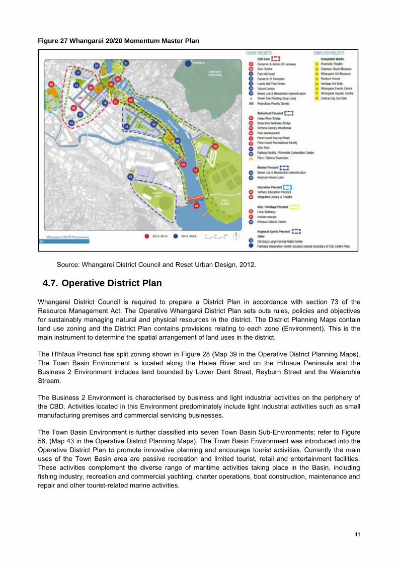
41
Figure 27 Whangarei 20/20 Momentum Master Plan
Source: Whangarei District Council and Reset Urban Design, 2012.
4.7. Operative District Plan
Whangarei District Council is required to prepare a District Plan in accordance with section 73 of the Resource Management Act. The Operative Whangarei District Plan sets outs rules, policies and objectives for sustainably managing natural and physical resources in the district. The District Planning Maps contain land use zoning and the District Plan contains provisions relating to each zone (Environment). This is the main instrument to determine the spatial arrangement of land uses in the district.
The Hīhīaua Precinct has split zoning shown in Figure 28 (Map 39 in the Operative District Planning Maps). The Town Basin Environment is located along the Hatea River and on the Hīhīaua Peninsula and the Business 2 Environment includes land bounded by Lower Dent Street, Reyburn Street and the Waiarohia Stream.
The Business 2 Environment is characterised by business and light industrial activities on the periphery of the CBD. Activities located in this Environment predominately include light industrial activities such as small manufacturing premises and commercial servicing businesses.
The Town Basin Environment is further classified into seven Town Basin Sub-Environments; refer to Figure 56, (Map 43 in the Operative District Planning Maps). The Town Basin Environment was introduced into the Operative District Plan to promote innovative planning and encourage tourist activities. Currently the main uses of the Town Basin area are passive recreation and limited tourist, retail and entertainment facilities. These activities complement the diverse range of maritime activities taking place in the Basin, including fishing industry, recreation and commercial yachting, charter operations, boat construction, maintenance and repair and other tourist-related marine activities.

42
Figure 28 Operative Whangarei District Plan Environment Map
District Wide Policy relevant to the Precinct include Chapter 5 Amenity Values, Chapter 6 Built Form and Development, Chapter 7 Tangata Whenua, Chapter 8 Subdivision and Development, Chapter 9 Financial Contribution, Chapter 10 The Coast, Chapter 11 Riparian and Coastal Margins, Chapter 13 Heritage Buildings Sites and Objects, Chapter 14 Heritage Trees, Chapter 15 Open Space, Chapter 16 Landscape, Chapter 19 Natural Hazards, Chapter 20 Contaminated Sites, Chapter 22 Road Transport and Chapter 26 Town Basin.
Resource Area Rules apply to areas of the district which have particular characteristics, values and qualities that require special management to protect these features, and to control activities that would adversely affect them. Resource Area Rules relating to the Hīhīaua Precinct include Chapter 56 Natural Hazard Areas- Flood Susceptible Areas, Chapter 58 Heritage Buildings, Sites and Objects, Chapter 59 Heritage Trees, Chapter 61 Esplanade Reserve Resource Area Rules and Chapter 63 Contaminated Sites.
Chapter 74 Subdivision Rules covers Business 1, 2, 3, 4, Town Basin, Marsden Point Port, Port Nikau, and Airport Environments. This chapter stipulates subdivision is a controlled activity subject to; allotment area, allotment shape, allotment frontage, existing buildings, Sites of Significance to Maori, property access, road and cycle layout and formation, street lighting, earthworks, infrastructure and telecommunication service provisions.
There is one designation in the Precinct imposed by Whangarei District Council in accordance with section 166 of the Resource Management Act. The designation is for the purpose of a car park. It covers the legal area of PT 16 SO 62510, which is situated along the Waiarohia Stream.
The majority of Hīhīaua Precinct is exempt from parking requirements, in accordance with Appendix 6 of the Operative Whangarei District Plan. Activities in this area are exempt from minimum parking requirements onsite, refer to Figure 29 (Figure 6A.1 in the Operative Whangarei District Plan).

43
Figure 29 Area Exempt from Parking Requirements
Source: Operative Whangarei District Council, 2007.
4.8. Open Space Strategy
The Open Space Strategy was adopted by Council in 2001. The Strategy intends to show how the Council will provide, develop and maintain a network of high quality open spaces to meet the needs of the City and the District in the future. The Strategy includes an assessment of existing spaces, future visions and priorities for open space. The Council’s core open space functions are to protect valued open space and to provide adequate recreation opportunities to meet the needs of the community into the future.
According to the Strategy, open spaces can be described according to the four main values they have: Conservation values including plants and animals, wildlife habitats and ecological processes. Landscape values including landform and land use, visual appreciation, and sense of place. Recreation values including the opportunity for active and passive, formal or informal recreation. Cultural values including sites with cultural or historic significance; they also arise from the lifestyle
patterns and preferences of the present culture.
Ten guiding principles for the management of open space have been developed. These are: 1 A heritage to be proud of. 2 Responding to pressure and demand. 3 Effective organization of recreation. 4 Potential for tourism. 5 Fostering conservation. 6 Enhancing urban areas. 7 Protecting and accessing the coast and streams. 8 Effective linkages. 9 Promoting partnerships. 10 Realistic goals.

44
The Open Space Strategy acknowledges that increasing the size of natural areas or connecting them with ecological corridors enhances their long-term viability. The Strategy proposes the development of recreational networks and ecological corridors along Whangarei’s streams, for example, from the Town Basin to the ‘town belt’ which could effectively link the suburbs within the City. It highlights the need for linking reserves, parks and riparian corridors for walking and cycling facilities. Creating a recreation network and ecological corridors will maximise the value and accessibility of open space and promote the viability of natural areas (Whangarei District Council, 2001).
The Open Space Strategy identifies a number of development projects for ‘destination parks’ and ‘recreation hubs’ in the district. Of relevance, it promotes development of a layout plan for Hīhīaua Open Space, including a village green concept, with special consideration for elderly and disabled people. The Town Basin’s children’s’ destination playground includes a swing for disabled children and the design of the Heritage Trail and Art Walk includes accessible features for all members of the public.
4.9. Walking and Cycling Strategy
The Walking and Cycling Strategy was adopted by Council in 2012. The Strategy outlines a long term plan for improving cycling and walking routes throughout the district. It prioritises proposed on-road and off-road tracks including an estimate of costs for the improvements to strategically develop a programme of priority actions. The Strategy promotes providing a safe transport system that works for pedestrian and cyclists. Providing walking and cycling infrastructure is critical in urban areas and a clear hierarchy of transport types, prioritising pedestrians, is a key principle of the Strategy.
Figure 30 Whangarei City Walkway/Cyclepath Network
Source: Whangarei District Council, 2012c
The Strategy was initially developed in 2007 in response to the growing awareness of the need to provide alternative methods of transport. Since the Strategy was adopted a number of major projects have started and some have been completed. These include State Highway 1 improvements, the CBD/Town Basin revitalisation and the Te Matau ā Pohe Bridge which will create an inner city ‘loop’ between the Town Basin and Pohe Island/William Fraser Memorial Park.

45
The Loop Walkway is a 4.2km walking and cycling path, 2.5m wide (where possible) which extends from the Town Basin to Te Matau ā Pohe in a loop around the Hatea River. Construction commenced in October 2013 and the new Te Matau ā Pohe Bridge includes pedestrian and cycling facilities completing the circuit from the Town Basin, along the Hatea River, over to Port Road and back to the Town Basin using Riverside Drive and the Victoria Bridge.
The Walking and Cycling Implementation Plan covers a 10 year period from 2011/2012 to 2021/2022 and is split into three key implementation streams to run concurrently. Stream 1 focuses on the Urban Whangarei Network. Projects have been prioritised to provide a comprehensive and safe network of cycleways and walkways linking Whangarei City with its urban growth nodes- Kamo, Maunu, Otaika, Onerahi and Tikipunga. The Urban Whangarei Network will connect pedestrian and cycling facilities in a comprehensive network (refer to Figure 30).
Stream 1 of the Implementation Plan prioritises projects based on linkages with other major infrastructure projects, such as the Lower Hatea crossing and State Highway 1 improvements, connecting projects and completing full routes where possible. A cycle/walk route from Raumanga Falls to Onerahi foreshore through the CBD and Town Basin was a key outcome of Implementation Stream 1 and construction has started for this route.
4.10. Parking Management Strategy
Whangarei District Council adopted the Parking Management Strategy in 2011 to provide a framework for managing parking in Whangarei.
The Strategy found Central Whangarei has an adequate supply of parking but Council needs to manage parking more efficiently by implementing the proposed parking management techniques outlined in the Strategy. The Strategy shifts away from traditional management techniques of ‘predict and provide’ to better manage existing parking resources and allow the market to determine appropriate levels of supply.
The Whangarei Growth Strategy identified a need for a ‘parking building on the southern fringe of the CBD (around Water Street) to service Forum North/CBD area, and another on the northern fringe of the CBD (around lower Hatea Drive) to service the Town Basin/CBD area’ (Whangarei District Council, 2011). To support the CBD and Town Basin into a pedestrian friendly environment, it is recommended off-street parking in Central Whangarei over time will reduced and be replaced by northern and southern multi-level parking buildings. As parking facilities are completed off-street parking should be reduced. A multi-level car park facility is not proposed within walking distance of the Hīhīaua Precinct. Should a large development be proposed, a multi-level car park facility could be examined further.
The Hīhīaua Precinct is exempt from parking requirements, in accordance with Appendix 6 of the Operative Whangarei District Plan (shown in Figure 6A.1 of the Operative District Plan). Therefore proposed activities within these areas are exempt from providing required or prescribed number of parking spaces for an activity. The Parking Strategy suggests minimum parking requirements can restrict development opportunities, contribute to sprawl and artificially hide the costs of parking. The Strategy suggests most businesses will provide parking as an incentive for their customers.
The future parking requirements of the Hīhīaua Precinct needs to be examined along with requirements across the district but it is envisaged that the exemption for onsite parking in the Precinct will remain.
4.11. Urban Design/ Sense of Place
Whangarei District Council signed the New Zealand Urban Design Protocol in December 2008. Since this time, Council has implemented a number of actions to incorporate urban design into its decision making process, including releasing an Urban Design Strategy in 2010 and establishing an Urban Design Panel in 2011.

46
Whangarei City and the inner city in particular, suffers from lack of good urban design in the past, excluding some of the more recent developments such as Forum North Library, the Town Basin and Cameron Street Mall. The Urban Design Strategy provides strategic direction for the design and development of the urban environment in a manner that will contribute to the sustainable future and success of the whole district. It is anticipated the Strategy will assist development to address the urban design needs of Whangarei, including the inner city.
Whangarei City has strong natural, historic and cultural attributes that if integrated into the urban fabric of the city could transform Whangarei into a highly desirable place to live, work, play and visit. Currently these attributes are not capitalised upon and as a consequence Whangarei City, particularly the Central City area, does not exhibit consistently high urban amenity nor a coherent sense of place. There are isolated areas of high amenity and strong sense of place, such as the Cameron Street Mall and the Town Basin. There are further improvements planned for the Town Basin and CBD. However, parts of the CBD and commercial areas remain unattractive, ill-kept, and afflicted with on-going vacant premises, resulting in a depressed, run-down appearance.
Whangarei’s Town Basin is an important and successful amenity and resource for Whangarei residents and visitors alike. It is one of the most valued areas in our district and the community has strong feelings of attachment, ownership and identity (Whangarei District Council, 2010b).
A strategic approach to long term development/redevelopment of the CBD, Town Basin and inner City is required. In the past, an ad hoc approach has been evident in initiating inner city improvements. A comprehensive development plan or precinct plan approach will assist to provide strategic direction to development that incorporates a vision of what the Central City should look like and address pedestrian connectivity issues particularly between the Town Basin and the CBD. Transforming the inner city from a car dominated to a people friendly environment is envisioned, and should be strongly promoted.
A key strategic component to such a transformation lies in introducing a residential population into and around the fringes of the CBD. This would contribute a local clientele base for the City’s retail and hospitality businesses, add vibrancy and vitality to city streets, and generate a sense of custodianship within the inner city via both passive surveillance and a sense of personal ownership and pride. However, to be successful residential and mixed use development in the inner city needs to be carefully managed to ensure high quality urban design outcomes and a coherent and attractive sense of place. Failing this development may become ad hoc and disjointed resulting in reduced amenity and lack of coherent sense of place.
Whangarei City has an extensive water-based edge and dramatic bush clad hills backdrop, which creates an attractive setting to the City Centre. The Hīhīaua Peninsula is a largely reclaimed area that provides a strong waterfront character with harbour/river frontage on two sides. The Precinct is currently occupied by varying styles of light industrial and commercial buildings. Along Reyburn Lane, in the vicinity of Reyburn House, there is a finer grain to the buildings with a combination of marine related businesses at ground floor level and a smattering of upper level apartments above. Although the standard of built form is neither consistent nor particularly high, it suggests a ‘boat shed and loft’ dwelling typology befitting the river/harbour context.
However, the remainder of the precinct is almost wholly occupied by large commercial sheds set in wide streets configured for large vehicle manoeuvring which are not conducive to pedestrian activity. Although commercial occupancy rates appear to be high, there is no shortage of land in Whangarei for commercial activity. The proximity of this Precinct to both the Town Basin and the CBD, together with a high amenity character potential derived from its waterfront location, give rise to a significantly greater potential value as a predominantly residential high density mixed use neighbourhood. However, for this potential to be realised it must be subject to rigorous urban design standards.
47
5. Part E: Hīhīaua Precinct Future Use
5.1. Introduction
The Hīhīaua Precinct is located in close proximity to Whangarei’s central business area and located between two waterways. The Precinct is approximately 16.5 hectares in size. Its location provides a unique opportunity to become a vibrant inner city residential/mixed use area.
The Hīhīaua Peninsula has been identified by Council as a potential area for inner city living and mixed use development (Whangarei District Council, 2010a; Whangarei District Council et al., 2006; Whangarei District Council and Reset Urban Design, 2012). The Hīhīaua Precinct will provide people who wish to live in medium/high density residential living in close proximity to the waterfront, Town Basin and the CBD the opportunity to do so. Medium/high living density will be achieved through providing a range of housing typologies including medium rise apartments, low rise apartments, terraced housing or town house development. Taking into account its proximity to social and cultural amenities and employment opportunities in Central Whangarei, this presents an opportunity and the capacity to revitalise the area into a vibrant inner city residential and mixed use area.
It is anticipated over time the Hīhīaua Precinct will transition into a high amenity, desirable medium/high density residential and mixed use area, subject to meeting engineering constraints relating to flood susceptibility, HAIL, land instability and ensuring reverse sensitivity impacts are mitigated and urban design criteria meet, particularly in the early stages of redevelopment.
Mixed use development will be situated in appropriate locations and contribute to the vitality and viability of the City. It is expected commercial activities will remain in the Precinct as well as introducing complementary mixed use activities such as entertainment facilities, tourist-related retail, recreation, community and hospitality activities such as restaurants and cafes.
The Hīhīaua Precinct was chosen for redevelopment to accommodate some of Whangarei’s growth and transform into an attractive residential/mixed use area as it is:
Located close to the geographic centre of Whangarei City. Located within walking distance to employment, amenities and services. Identified by Council as a strategic location for residential/ mixed use development. A large consolidated area of land in local government ownership. Adjacent to Whangarei’s waterways and high amenity areas e.g. The Town Basin, looped walkway. Supported by public interest for inner city living.
Over time, as light industrial activities relocate to other appropriate sites, this will free land for residential and mixed use redevelopment. Objectives, policies and rules in the District Plan along with a change of land use zoning, will provide opportunities for residential/mixed use activities and encourage the development of a connected Open Space Network.
5.2. Residential Capacity Analysis
The Hīhīaua Precinct was divided into four Sub-Precincts to assist infrastructure capacity analysis, residential capacity analysis and describe outcomes for specific areas. The Sub-Precincts include; the Hatea River Sub-Precinct, Central Hīhīaua Sub-Precinct, Waiarohia Stream Sub-Precinct and the Reyburn Street Sub-Precinct. Refer to Figure 31.
These projections on residential capacity assume the land is vacant and therefore a ‘brownfield’ site where comprehensive re-development opportunities would be available. Table 3 illustrates projected residential capacity without any constraints.

48
Figure 31 Hīhīaua Sub-Precincts
Table 3 Residential Capacity Analysis
Hatea River Sub-Precinct
Waiarohia Stream Sub-Precinct
Central Hīhīaua Sub-Precinct
Reyburn Street Sub- Precinct
Total
Area 1.4 ha 1.3 ha 3. 0 ha 1.8ha 7.5 ha
Option 1: 300 m2
Detached/semi detached
48 dwellings 115 residents (34 dwlg* per ha)
43 dwellings 103 residents (33 dwlg per ha)
100 dwellings 240 residents (33 dwlg per ha)
60 dwellings 144 residents (33 dwlg per ha)
251 dwellings 602 residents (33 dwlg per ha)
Option 2:250 m2
Duplex or townhouse
58 dwellings 139 residents (41 dwlg per ha)
52 dwellings 125 residents (40 dwlg per ha)
120 dwellings 288 residents (40 dwlg per ha)
72 dwellings 173 residents (40 dwlg per ha)
302 dwellings 725 residents (40 dwlg per ha)
Option 3: 150m2
Terraced houses 96 dwellings 230 residents (68 dwlg per ha)
85 dwellings 204 residents (65 dwlg per ha)
200 dwellings 480 residents (67 dwlg per ha)
120 dwellings 288 residents (67 dwlg per ha)
501 dwellings 1,202 residents (67 dwlg per ha)
Option 4: 100 m2 Apartments NB: 1.5 ppl/dw
(2 storeyed) 288 dwellings 432 residents (205 dwellings per ha)
(2 storeyed) 260 dwellings 390 residents (200 dwellings per ha)
(4 storeyed) 1,200 dwellings 1,800 residents (400 dwellings per ha)
(4 storeyed) 720 dwellings 1,080 residents (400 dwellings per ha)
2,468 dwellings 3,702 residents (329 dwellings per ha)
Note: According to the 2006 Census, Whangarei’s average household size was 2.6 people per household. Over time trends indicate household size will decrease. The table assumes an average household of 2.4 people per household except Option 4 which uses 1.5 people per dwelling as a baseline for calculating the residential population. *dwlg means dwelling.

49
5.3. Density
Density refers to the number of dwelling units (and, by association, the number of people) that could be located on a particular property/parcel of land. Density is often referenced as units per hectare and generally indicates how intensely a site is used. Figure 32 illustrates the transition of density from rural to urban.
There are different measures of density such as population, employment, residential and activity density for different planning and design purposes. Population and activity densities measure the concentration of people. Residential density measures the concentration of dwellings in a given land area. To calculate the residential density the basic ratio formula is used:
Number of dwellings Area of land occupied
Figure 32 Urban Transect
Site and net residential densities are used at the smaller scale of lots, blocks and precincts which exclude roads and related transport infrastructure. Gross residential densities are used at the neighbourhood or district level. Gross densities are used for the Hīhīaua Precinct.
There are approximately 10 dwellings per hectare (gross) in Whangarei’s inner suburbs. This is regarded as a low residential density. Whangarei City suburbs are characterised by predominately traditional suburban, detached houses on individual sections. If current dwelling density is maintained, cities will continue to sprawl and grow the urban footprint. One key objective of the Whangarei District Growth Strategy 30/50 is to consolidate development and manage growth based upon a structured five tier settlement pattern.
The Hīhīaua Precinct Plan will provide medium to high density residential development opportunities. Medium density is regarded as 15-25 dwellings per hectare (gross) and high density is considered 30+ dwellings per hectare (gross).
It is envisaged the Hīhīaua Precinct will have a varied density across the area due to a mix of activities and varied housing typologies proposed. Sub-Precincts such as the Central Hīhīaua Sub-Precinct may have higher residential density than others.
Medium to high density residential development located within, or in close proximity to Central Whangarei, is a key component for achieving urban consolidation. Increasing the dwelling density will promote a more efficient and compact urban form. Encouraging higher densities can also assist in a modal shift from the private car to public transport and walking/cycling options. A permanent residential population will assist to transform the City into a vibrant destination.

50
5.4. Housing Type
A diverse housing typology is critical to providing a higher residential density within Central Whangarei whilst providing a choice of living options. It is expected that dwelling types will vary within the Hīhīaua Precinct and there will not be a uniform density across the Precinct. A range building typologies are proposed in the Precinct including low/medium rise apartments, terraced houses, semi-detached houses and live/work options. This will offer housing options to suit a range of incomes and household structures and tenures.
5.4.1. Medium/High Rise Apartments
Figure 33 The Docks Apartments, Auckland (45-80 dwellings/hectare- high density)
Medium rise apartment buildings are usually between four to eight storeys high, with a floor area of 150m2 per unit or less. Ownership is usually unit title with a body corporate. Pedestrian and vehicle access is usually shared with parking provided on the basement or ground level. Outdoor living space is provided by individual balconies for each unit. Some facilities such as a gym or swimming pool may be shared.
In this example the buildings are residential from top to bottom. In close proximity to city centres they can contribute to inner city pedestrian vitality and lower vehicular dependency. They can also be appropriate near large open parklands which mitigate the impact of their bulk and scale and offer residents shared open space amenity. Apartments can offer a smaller/low maintenance housing option and cheaper heating/service bills through improved thermal performance of the structure.
5.4.2. Low Rise Apartments
Figure 34 Talbot Park, Auckland (20-40 dwellings/hectare- medium to high density)
Low rise apartments are usually in a building, with a maximum height of three storeys. This ensures that residents maintain a relatively close relationship with the street.
The floor area is typically between 50m2 and 300m2
per unit, with outdoor living area provided by a balcony or patio for each unit. Ground floor apartments will typically have an outdoor living space or courtyard where as apartments on upper floors typically have balconies.
Low rise apartments or walk-up apartments are low maintenance with cheaper heating/service bills. They suit people wanting a reasonable sized living space, but less space outside to look after.
Apartments are usually single storey self-contained units within a larger building, but sometimes apartments have more than one storey. Usually there is common access to a core stairwell and often rubbish storage/ recycling facilities is communal.
Some facilities such as a gym, swimming pool or underground/ground floor car parking may be shared. Titles are usually unit title and operated under a body corporate.

51
5.4.3. Mixed Use
Figure 35 Mixed Use, Parnell, Auckland (15-30 dwellings/hectare- medium to high density)
Mixed use means providing space for commercial and residential activities in the same building (vertical mixed use). Located in town and neighbourhood centres, the mix of uses brings more vitality to local streets both during and outside commercial hours. Typically commercial activities are located on the ground level creating an active street edge and residential activities are on subsequent levels.
5.4.4. Semi Detached Town Houses
Figure 36 Talbot Park, Auckland (15-20 dwellings/hectare- medium density)
Semi detached houses have a common or shared wall with their own access from the street and separate small gardens or courtyards. The site area per unit ranges between 200m2 and 350m2. Off street parking is provided usually in garages. The height is normally two/three storeys and they are often built in linear fashion following the alignment of the site or oriented perpendicular to the street. Titles can be fee simple, cross lease or unit title.
Town houses can provide a more affordable option than a standard house on a typical section and suit smaller sized households.
5.4.5. Terraced Housing
Figure 37 Auckland Domain Terraced Housing (20-40 dwellings/hectare- medium to high density)
Terrace housing is also commonly known as row housing. Terraced housing refers to attached dwellings sharing side walls. These are invariably built with direct access onto the street or private access way. Site area is usually between 150m2 to 300 m2 per unit.
Terraced housing can assist to reduce heating bills and are typically low maintenance buildings.
Separate off-street parking is usually provided although vehicle access may be shared. Each has a separate courtyard. Terraced housing is usually two to three storeys high, each unit having more than one storey- that is, units are orientated vertically. Titles can be fee simple or unit title.
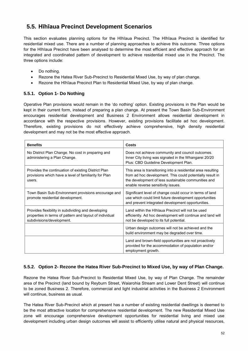
52
5.5. Hīhīaua Precinct Development Scenarios
This section evaluates planning options for the Hīhīaua Precinct. The Hīhīaua Precinct is identified for residential mixed use. There are a number of planning approaches to achieve this outcome. Three options for the Hīhīaua Precinct have been analysed to determine the most efficient and effective approach for an integrated and coordinated pattern of development to achieve residential mixed use in the Precinct. The three options include:
Do nothing. Rezone the Hatea River Sub-Precinct to Residential Mixed Use, by way of plan change. Rezone the Hīhīaua Precinct Plan to Residential Mixed Use, by way of plan change.
5.5.1. Option 1- Do Nothing
Operative Plan provisions would remain in the ‘do nothing’ option. Existing provisions in the Plan would be kept in their current form, instead of preparing a plan change. At present the Town Basin Sub-Environment encourages residential development and Business 2 Environment allows residential development in accordance with the respective provisions. However, existing provisions facilitate ad hoc development. Therefore, existing provisions do not effectively achieve comprehensive, high density residential development and may not be the most effective approach.
Benefits Costs
No District Plan Change. No cost in preparing and administering a Plan Change.
Does not achieve community and council outcomes. Inner City living was signaled in the Whangarei 20/20 Plus: CBD Guideline Development Plan.
Provides the continuation of existing District Plan provisions which have a level of familiarity for Plan users.
This area is transitioning into a residential area resulting from ad hoc development. This could potentially result in the development of less sustainable communities and enable reverse sensitivity issues.
Town Basin Sub-Environment provisions encourage and promote residential development.
Significant level of change could occur in terms of land use which could limit future development opportunities and prevent integrated development opportunities.
Provides flexibility in subdividing and developing properties in terms of pattern and layout of individual subdivisions/development.
Land within the Hīhīaua Precinct will not be used efficiently. Ad hoc development will continue and land will not be developed to its full potential.
Urban design outcomes will not be achieved and the build environment may be degraded over time.
Land and brown-field opportunities are not proactively provided for the accommodation of population and/or employment growth.
5.5.2. Option 2- Rezone the Hatea River Sub-Precinct to Mixed Use, by way of Plan Change.
Rezone the Hatea River Sub-Precinct to Residential Mixed Use, by way of Plan Change. The remainder area of the Precinct (land bound by Reyburn Street, Waiarohia Stream and Lower Dent Street) will continue to be zoned Business 2. Therefore, commercial and light industrial activities in the Business 2 Environment will continue, business as usual.
The Hatea River Sub-Precinct which at present has a number of existing residential dwellings is deemed to be the most attractive location for comprehensive residential development. The new Residential Mixed Use zone will encourage comprehensive development opportunities for residential living and mixed use development including urban design outcomes will assist to efficiently utilise natural and physical resources,
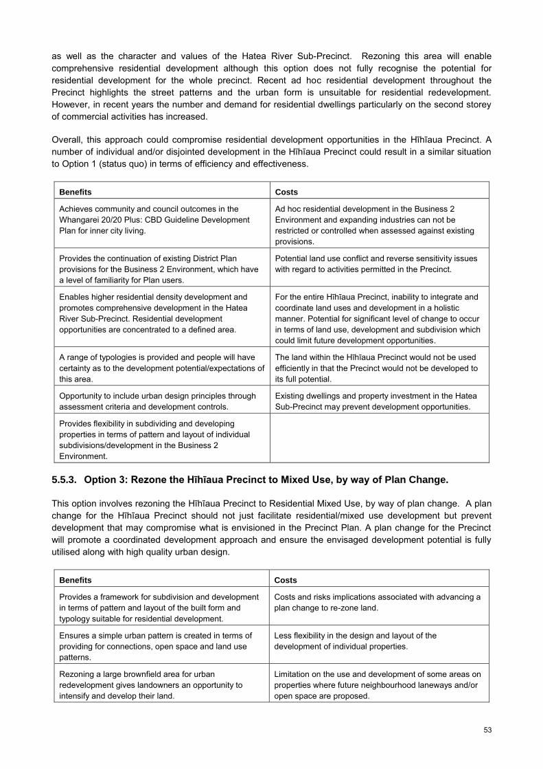
53
as well as the character and values of the Hatea River Sub-Precinct. Rezoning this area will enable comprehensive residential development although this option does not fully recognise the potential for residential development for the whole precinct. Recent ad hoc residential development throughout the Precinct highlights the street patterns and the urban form is unsuitable for residential redevelopment. However, in recent years the number and demand for residential dwellings particularly on the second storey of commercial activities has increased.
Overall, this approach could compromise residential development opportunities in the Hīhīaua Precinct. A number of individual and/or disjointed development in the Hīhīaua Precinct could result in a similar situation to Option 1 (status quo) in terms of efficiency and effectiveness.
Benefits Costs
Achieves community and council outcomes in the Whangarei 20/20 Plus: CBD Guideline Development Plan for inner city living.
Ad hoc residential development in the Business 2 Environment and expanding industries can not be restricted or controlled when assessed against existing provisions.
Provides the continuation of existing District Plan provisions for the Business 2 Environment, which have a level of familiarity for Plan users.
Potential land use conflict and reverse sensitivity issues with regard to activities permitted in the Precinct.
Enables higher residential density development and promotes comprehensive development in the Hatea River Sub-Precinct. Residential development opportunities are concentrated to a defined area.
For the entire Hīhīaua Precinct, inability to integrate and coordinate land uses and development in a holistic manner. Potential for significant level of change to occur in terms of land use, development and subdivision which could limit future development opportunities.
A range of typologies is provided and people will have certainty as to the development potential/expectations of this area.
The land within the Hīhīaua Precinct would not be used efficiently in that the Precinct would not be developed to its full potential.
Opportunity to include urban design principles through assessment criteria and development controls.
Existing dwellings and property investment in the Hatea Sub-Precinct may prevent development opportunities.
Provides flexibility in subdividing and developing properties in terms of pattern and layout of individual subdivisions/development in the Business 2 Environment.
5.5.3. Option 3: Rezone the Hīhīaua Precinct to Mixed Use, by way of Plan Change.
This option involves rezoning the Hīhīaua Precinct to Residential Mixed Use, by way of plan change. A plan change for the Hīhīaua Precinct should not just facilitate residential/mixed use development but prevent development that may compromise what is envisioned in the Precinct Plan. A plan change for the Precinct will promote a coordinated development approach and ensure the envisaged development potential is fully utilised along with high quality urban design.
Benefits Costs
Provides a framework for subdivision and development in terms of pattern and layout of the built form and typology suitable for residential development.
Costs and risks implications associated with advancing a plan change to re-zone land.
Ensures a simple urban pattern is created in terms of providing for connections, open space and land use patterns.
Less flexibility in the design and layout of the development of individual properties.
Rezoning a large brownfield area for urban redevelopment gives landowners an opportunity to intensify and develop their land.
Limitation on the use and development of some areas on properties where future neighbourhood laneways and/or open space are proposed.
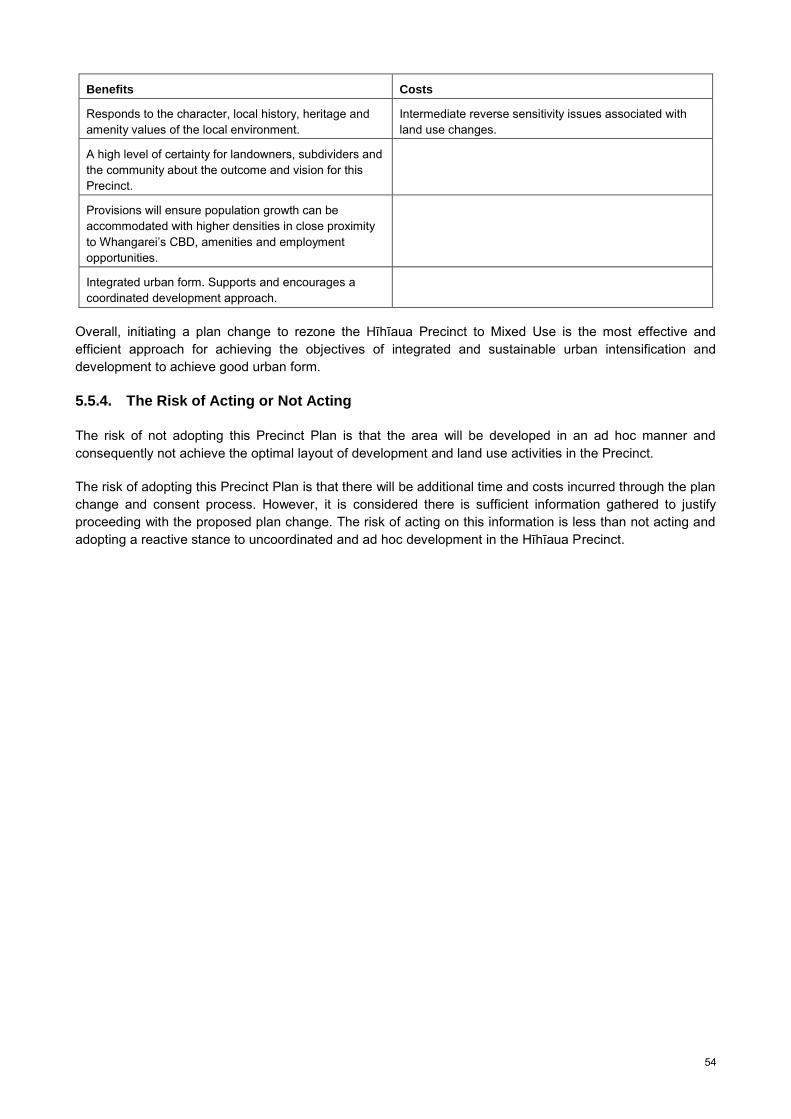
54
Benefits Costs
Responds to the character, local history, heritage and amenity values of the local environment.
Intermediate reverse sensitivity issues associated with land use changes.
A high level of certainty for landowners, subdividers and the community about the outcome and vision for this Precinct.
Provisions will ensure population growth can be accommodated with higher densities in close proximity to Whangarei’s CBD, amenities and employment opportunities.
Integrated urban form. Supports and encourages a coordinated development approach.
Overall, initiating a plan change to rezone the Hīhīaua Precinct to Mixed Use is the most effective and efficient approach for achieving the objectives of integrated and sustainable urban intensification and development to achieve good urban form.
5.5.4. The Risk of Acting or Not Acting
The risk of not adopting this Precinct Plan is that the area will be developed in an ad hoc manner and consequently not achieve the optimal layout of development and land use activities in the Precinct.
The risk of adopting this Precinct Plan is that there will be additional time and costs incurred through the plan change and consent process. However, it is considered there is sufficient information gathered to justify proceeding with the proposed plan change. The risk of acting on this information is less than not acting and adopting a reactive stance to uncoordinated and ad hoc development in the Hīhīaua Precinct.

55
5.6. Hīhīaua Precinct Concept Framework Plan
The Concept Plan provides an overall framework for future development and identifies key opportunities in the Hīhīaua Precinct. The Concept Framework Plan identifies key changes in the Precinct including changing the land use, enhancing the Blue/Green Network, enhancing the walking and cycling network, encouraging physical connections to the water and identifying strategic locations for catalyst projects/development (refer to Figure 38). This concept originates and builds on principles from the CBD Guideline Development Plan- 20/20 Plus.
Key elements of the Concept Plan include; landuse, built form, access and movement, open space and community facilities/catalyst projects. The Concept Plan is indicative only and is intended as a conceptual guideline. Indicative concepts may assist to guide future development, although it is recognised the methods used to achieve the desired outcomes may be varied.
Figure 38 Hīhīaua Precinct Concept Framework Plan
Medium to high density residential/mixed use development is proposed. This will typically include low rise apartments, terraced housing, semi-detached housing and live/work units.
The maximum height of the Hatea River and Waiarohia Precincts are two to three storeys (with a possible extension to four storeys along Lower Dent Street frontage). Residential/mixed use development is envisaged along Reyburn House Lane and Lower Dent Street. Live/work arrangements are envisioned along Herekino Street.
The maximum height of six storeys in the Central and Reyburn Street Sub-Precincts with the most likely, and preferred heights of two to four storeys. These Sub-Precincts require less prescriptive height limits. Terraced housing, semi-detached housing and low rise buildings are preferred, taking into consideration geotechnical

56
constraints. Two to four storey residential redevelopment, mixed use activities is envisioned and commercial redevelopment/mixed use is envisaged along Reyburn Street, due to geotechnical constraints.
Small scale supporting commercial uses, tourist related activities, community facilities and recreational activities are envisioned. Appropriate local shops and services such as a childcare facility are envisioned to meet the demands of the new residential population. Small scale commercial activities may include boutique shops, cafes, restaurants, limited office, recreation and tourist oriented activities and a local convenience store. Mixed use development located in strategic locations will add to the vitality and viability of the Precinct. Small scale commercial/tourist activities such as boutique shops and cafe/restaurants on the ground level and residential uses above, is considered appropriate.
Open space in the Precinct will consist of a pedestrian walkway and cycle way which will in the long term connect to a Blue/Green Network in Central Whangarei. This will also link to the 4.2km Loop Walkway around the Town Basin. The open space on the Hīhīaua Peninsula will continue as a passive recreation area however, with opportunities to include landscaping features and potential catalyst projects. Pocket parks or plazas may be located within the Precinct as development proceeds.
Local roads are proposed to provide access to residential and commercial activities (shown in Figure 53). Reducing the size of the blocks in the central areas will encourage a walkable environment and enable people to move freely in the Precinct.
A catalyst project, a Hīhīaua Cultural Centre, is proposed on the Hīhīaua Peninsula open space area. The Hīhīaua Cultural Centre is a unique opportunity to create a landmark building, resource and facility for the district.
A summary of the key elements in the Concept Framework Plan are set out in Table 4.
Table 4 Key Elements of the Concept Framework Plan
Element Description
Residential Use A medium/high density urban neighbourhood.
Mix of housing typologies and sizes including town houses, terraced houses, apartments and work/live options.
Mixed Use Combination or mix of uses within a building.
A range of tourist-related activities, community uses, recreation activities and small scale commercial uses that serve the needs of the local community.
Built Form Building heights ranging from two to four (maximum six) storeys.
Low-rise town houses, terraced housing and live/work arrangements typically situated along the Hatea River and Waiarohia Stream.
Medium rise (two to four storeys) in the centre of the Precinct comprised of predominately apartments and terraced housing.
Open Space A large open space situated on the Peninsula for passive recreation.
Well connected Blue/Green Network which provides continuous public access along esplanade of the Hatea River and Waiarohia Stream.
Potential for pocket parks and plazas for local residents.
Movement Network A publicly accessible foreshore with continuous cycling and walking paths.
Walking and cycling network and associated infrastructure.
A proposed network of local roads will enhance connectivity within the Precinct.
A hierarchy of roads in the Precinct.
Community Facilities/Catalyst Project
Proposed Hīhīaua Maori Cultural Centre which will include a theatre, conference facility, large display rooms, outdoor courtyards, outdoor stage, Waka carving facility and Waka store amongst other facilities.

57
5.6.1. Sub-Precinct Concept Plans
Concept Plans for the four Sub-Precincts were created to describe in more detail what is envisioned. The Sub-Precincts include; the Hatea River Sub-Precinct, Waiarohia Stream Sub-Precinct, Central Hīhīaua Sub-Precinct, and the Reyburn Street Sub-Precinct. Refer to Figure 31.
5.6.1.1. Hatea River Sub-Precinct
The Hatea River Sub-Precinct currently has a variety of activities including light industry, commercial services, cultural/entertainment activities, offices, medical services, retail and residential uses. There are nine residential dwellings, mostly located on the second floor, above commercial activities. The Hatea River Sub-Precinct has a unique character fronting onto open space and the Hatea River and is serviced by Reyburn House Lane and Lower Dent Street which provide front and rear access for businesses. Buildings are oriented mostly facing Dent Street.
Figure 39 Hatea River Sub-Precinct Concept Plan
The Hatea River Sub-Precinct has high amenity, good waterfront views, little traffic and excellent access to Whangarei City centre and Town Basin amenities. The Sub-Precinct fronts a large area of open space along the Hatea River. A number of arts and cultural facilities including the Northland Art Society (Reyburn House), Whangarei Theatre Company, the Heritage Trail and Art Walk are located along the Hatea River and the ‘Waka and Wave’ sculpture is located near the point of the peninsular.
At present the Town Basin is a central social and passive recreation area for Whangarei. The Hatea River Sub-Precinct builds on cultural and arts activities and complements the Town Basin tourist activities and amenities. The loop walkway will enhance/improve connections around the Hatea River and connect to existing attractions in the area such as the Town Basin, ‘Waka and Wave’ Sculpture, Whangarei Aquatic Centre and active recreation facilities on Pohe Island such as the skate park and sports grounds. The loop walkway will draw people to the riverfront area and connect the Hatea waterfront to adjacent areas.
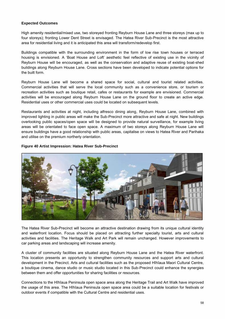
58
Expected Outcomes
High amenity residential/mixed use, two storeyed fronting Reyburn House Lane and three storeys (max up to four storeys); fronting Lower Dent Street is envisaged. The Hatea River Sub-Precinct is the most attractive area for residential living and it is anticipated this area will transform/redevelop first.
Buildings compatible with the surrounding environment in the form of low rise town houses or terraced housing is envisioned. A ‘Boat House and Loft’ aesthetic feel reflective of existing use in the vicinity of Reyburn House will be encouraged, as well as the conservation and adaptive reuse of existing boat-shed buildings along Reyburn House Lane. Cross sections have been developed to indicate potential options for the built form.
Reyburn House Lane will become a shared space for social, cultural and tourist related activities. Commercial activities that will serve the local community such as a convenience store, or tourism or recreation activities such as boutique retail, cafes or restaurants for example are envisioned. Commercial activities will be encouraged along Reyburn House Lane on the ground floor to create an active edge. Residential uses or other commercial uses could be located on subsequent levels.
Restaurants and activities at night, including alfresco dining along, Reyburn House Lane, combined with improved lighting in public areas will make the Sub-Precinct more attractive and safe at night. New buildings overlooking public spaces/open space will be designed to provide natural surveillance, for example living areas will be orientated to face open space. A maximum of two storeys along Reyburn House Lane will ensure buildings have a good relationship with public areas, capitalise on views to Hatea River and Parihaka and utilise on the premium northerly orientation.
Figure 40 Artist Impression: Hatea River Sub-Precinct
The Hatea River Sub-Precinct will become an attractive destination drawing from its unique cultural identity and waterfront location. Focus should be placed on attracting further specialty tourist, arts and cultural activities and facilities. The Heritage Walk and Art Park will remain unchanged. However improvements to car parking areas and landscaping will increase amenity.
A cluster of community facilities are situated along Reyburn House Lane and the Hatea River waterfront. This location presents an opportunity to strengthen community resources and support arts and cultural development in the Precinct. Arts and cultural facilities such as the proposed Hīhīaua Maori Cultural Centre, a boutique cinema, dance studio or music studio located in this Sub-Precinct could enhance the synergies between them and offer opportunities for sharing facilities or resources.
Connections to the Hīhīaua Peninsula open space area along the Heritage Trail and Art Walk have improved the usage of this area. The Hīhīaua Peninsula open space area could be a suitable location for festivals or outdoor events if compatible with the Cultural Centre and residential uses.

59
It is envisioned Reyburn House Lane will become a shared space. Vehicle access is currently permitted and pedestrian mobility will be encouraged. Removed kerbs and single level paving across the full width of the street creates uncertainty particularly for vehicle uses. In turn, drivers tend to reduce their speed as they assess the new environment and interact with pedestrians in a different way. Shared space combined with commercial uses locating along Reyburn House Lane, activating the edges will attract more pedestrian traffic to the area.
Lower Dent Street will become a tree-lined boulevard. Street trees in the precinct will increase the amenity of the area and increase urban biodiversity.
5.6.1.2. Waiarohia Stream Sub-Precinct
The Waiarohia Stream Sub-Precinct currently has a range of commercial, industrial and professional services such as Ministry offices for Primary Industries and Fisheries, sign writers, automotive services, panel-beaters, accountants and marine related activities. Other activities include a play centre and two lunch bars. There are no residential dwellings currently in the Waiarohia Sub-Precinct.
Figure 41 Waiarohia Stream Sub-Precinct Concept Plan
The Land Use Survey completed by Council in January, 2013, found four large premises unoccupied (totalling approximately 0.5ha in this Sub-Precinct).
A number of buildings along Herekino Street occupy a considerable area of the site. In some situations the building footprint exceeds the rear boundary, therefore impinging an area that could be created for an esplanade reserve or strip. Access to or along the Waiarohia Stream is therefore restricted or obstructed by structures in some areas.
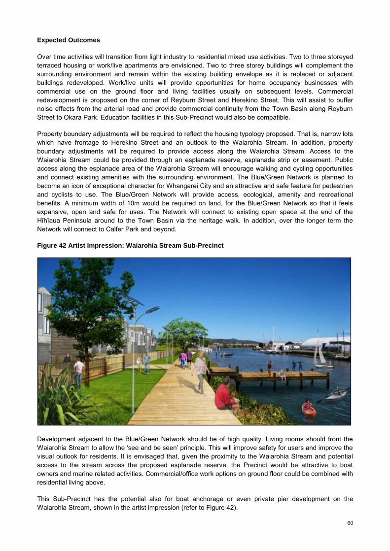
60
Expected Outcomes
Over time activities will transition from light industry to residential mixed use activities. Two to three storeyed terraced housing or work/live apartments are envisioned. Two to three storey buildings will complement the surrounding environment and remain within the existing building envelope as it is replaced or adjacent buildings redeveloped. Work/live units will provide opportunities for home occupancy businesses with commercial use on the ground floor and living facilities usually on subsequent levels. Commercial redevelopment is proposed on the corner of Reyburn Street and Herekino Street. This will assist to buffer noise effects from the arterial road and provide commercial continuity from the Town Basin along Reyburn Street to Okara Park. Education facilities in this Sub-Precinct would also be compatible.
Property boundary adjustments will be required to reflect the housing typology proposed. That is, narrow lots which have frontage to Herekino Street and an outlook to the Waiarohia Stream. In addition, property boundary adjustments will be required to provide access along the Waiarohia Stream. Access to the Waiarohia Stream could be provided through an esplanade reserve, esplanade strip or easement. Public access along the esplanade area of the Waiarohia Stream will encourage walking and cycling opportunities and connect existing amenities with the surrounding environment. The Blue/Green Network is planned to become an icon of exceptional character for Whangarei City and an attractive and safe feature for pedestrian and cyclists to use. The Blue/Green Network will provide access, ecological, amenity and recreational benefits. A minimum width of 10m would be required on land, for the Blue/Green Network so that it feels expansive, open and safe for uses. The Network will connect to existing open space at the end of the Hīhīaua Peninsula around to the Town Basin via the heritage walk. In addition, over the longer term the Network will connect to Calfer Park and beyond.
Figure 42 Artist Impression: Waiarohia Stream Sub-Precinct
Development adjacent to the Blue/Green Network should be of high quality. Living rooms should front the Waiarohia Stream to allow the ‘see and be seen’ principle. This will improve safety for users and improve the visual outlook for residents. It is envisaged that, given the proximity to the Waiarohia Stream and potential access to the stream across the proposed esplanade reserve, the Precinct would be attractive to boat owners and marine related activities. Commercial/office work options on ground floor could be combined with residential living above.
This Sub-Precinct has the potential also for boat anchorage or even private pier development on the Waiarohia Stream, shown in the artist impression (refer to Figure 42).
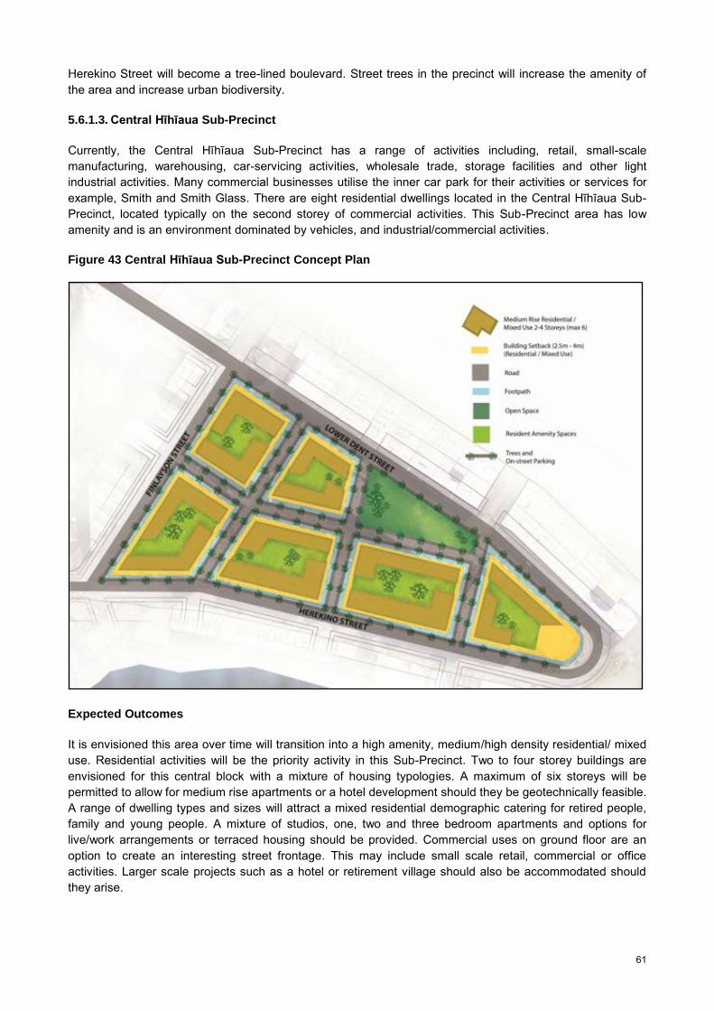
61
Herekino Street will become a tree-lined boulevard. Street trees in the precinct will increase the amenity of the area and increase urban biodiversity.
5.6.1.3. Central Hīhīaua Sub-Precinct
Currently, the Central Hīhīaua Sub-Precinct has a range of activities including, retail, small-scale manufacturing, warehousing, car-servicing activities, wholesale trade, storage facilities and other light industrial activities. Many commercial businesses utilise the inner car park for their activities or services for example, Smith and Smith Glass. There are eight residential dwellings located in the Central Hīhīaua Sub-Precinct, located typically on the second storey of commercial activities. This Sub-Precinct area has low amenity and is an environment dominated by vehicles, and industrial/commercial activities.
Figure 43 Central Hīhīaua Sub-Precinct Concept Plan
Expected Outcomes
It is envisioned this area over time will transition into a high amenity, medium/high density residential/ mixed use. Residential activities will be the priority activity in this Sub-Precinct. Two to four storey buildings are envisioned for this central block with a mixture of housing typologies. A maximum of six storeys will be permitted to allow for medium rise apartments or a hotel development should they be geotechnically feasible. A range of dwelling types and sizes will attract a mixed residential demographic catering for retired people, family and young people. A mixture of studios, one, two and three bedroom apartments and options for live/work arrangements or terraced housing should be provided. Commercial uses on ground floor are an option to create an interesting street frontage. This may include small scale retail, commercial or office activities. Larger scale projects such as a hotel or retirement village should also be accommodated should they arise.

62
Parking and public/semi-public open space need to be carefully considered. Proposed open space will enhance the amenity of the Central Sub-Precinct and alleviate any pressure on existing open space. Providing a neighbourhood park will enable residents to utilise this area for passive or active recreation.
North to south road connections through the Sub-Precinct is proposed and a west to east road connection to create a legible block structure suitable for residential redevelopment. This block structure will encourage intermodal accessibility and physical and visual permeability for this building typology (predominately low/medium rise apartments). The site layout and building design encourages buildings to have a close relationship with the public areas/streets and will provide natural surveillance onto these areas (shown in Figure 44). The block structure and urban form is optimal for low/medium rise residential redevelopment however, if for example a terraced housing typology was planned for this area the block structure would not be suitable.
Innovative parking is required. Underground parking options are likely to be costly due to physical and geotechnical constraints. However, the high cost could be offset by a high residential yield. If basement or semi-basement parking is feasible for the site, it may present better design opportunities for communal/shared open space area(s) that could increase the value and amenity of development.
Streets in the Precinct were historically configured for commercial and light industrial activities, prioritising large vehicles. The street network proposed has restrictive lane widths suitable for neighbourhood streets and adopt traffic calming options such as street trees to create a pedestrian-friendly environment with high amenity. Wide footpath promotes a walkable neighbourhood and will transform it from a car oriented environment to a people oriented area. In addition, to create a more intimate neighbourhood street corridor, it is recommended that upper level balconies be permitted to overhang the street by up to 2.5m on each side to create a more intimate perception of street corridor widths befitting a primarily residential neighbourhood. An indicative cross section (Figure 51) illustrates a development option that takes into consideration parking and streetscape.
Figure 44 Artist Impression: Central Hīhīaua Sub-Precinct
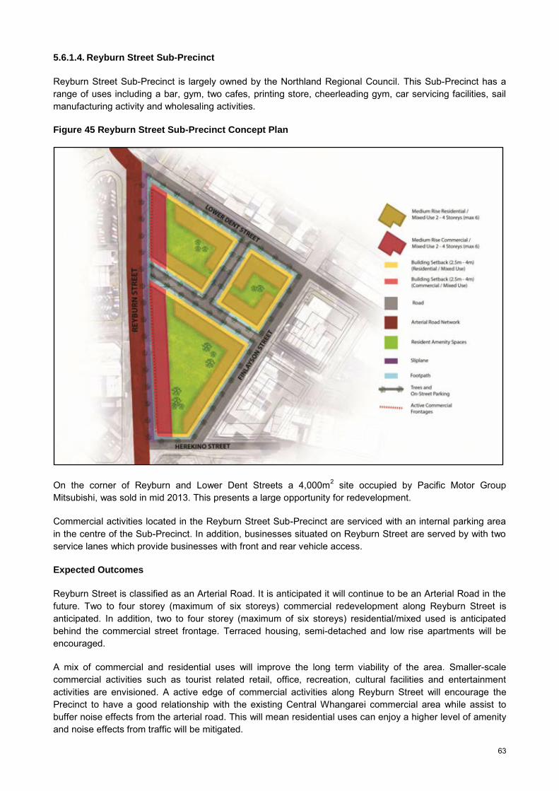
63
5.6.1.4. Reyburn Street Sub-Precinct
Reyburn Street Sub-Precinct is largely owned by the Northland Regional Council. This Sub-Precinct has a range of uses including a bar, gym, two cafes, printing store, cheerleading gym, car servicing facilities, sail manufacturing activity and wholesaling activities.
Figure 45 Reyburn Street Sub-Precinct Concept Plan
On the corner of Reyburn and Lower Dent Streets a 4,000m2 site occupied by Pacific Motor Group Mitsubishi, was sold in mid 2013. This presents a large opportunity for redevelopment.
Commercial activities located in the Reyburn Street Sub-Precinct are serviced with an internal parking area in the centre of the Sub-Precinct. In addition, businesses situated on Reyburn Street are served by with two service lanes which provide businesses with front and rear vehicle access.
Expected Outcomes
Reyburn Street is classified as an Arterial Road. It is anticipated it will continue to be an Arterial Road in the future. Two to four storey (maximum of six storeys) commercial redevelopment along Reyburn Street is anticipated. In addition, two to four storey (maximum of six storeys) residential/mixed used is anticipated behind the commercial street frontage. Terraced housing, semi-detached and low rise apartments will be encouraged.
A mix of commercial and residential uses will improve the long term viability of the area. Smaller-scale commercial activities such as tourist related retail, office, recreation, cultural facilities and entertainment activities are envisioned. A active edge of commercial activities along Reyburn Street will encourage the Precinct to have a good relationship with the existing Central Whangarei commercial area while assist to buffer noise effects from the arterial road. This will mean residential uses can enjoy a higher level of amenity and noise effects from traffic will be mitigated.

64
Medium rise residential apartments and terraced housing, two to four storeys is envisaged in this Sub-Precinct. A range of dwelling types and sizes in high quality buildings will attract a diverse residential population. This would include retiree/elderly people, families and student oriented apartments/dwellings.
5.6.2. Built Form and Design Guidelines
The Hīhīaua Precinct is adjacent to two water bodies, the Hatea River and the Waiarohia Stream. Its light industrial character and its waterfront location have motivated a modern marine inspired architectural theme for the Precinct. Buildings along Reyburn House Lane will be encouraged to maintain the boat-house and loft typology and development along the Waiarohia Stream will encourage living areas to have south facing outlook onto the water. In keeping with the architectural theme and ground conditions, light weight structures will be encouraged.
The Precinct currently has a coarse block structure as a result of present commercial uses occupying the land. A finer grain block structure is envisaged to establish a legible built environment suitable for residential use. The proposed block structure responds to the natural landscape features of the Peninsula including the Hatea River, Waiarohia Stream, associated open space areas and the existing local road network.
Figure 46 Indicative Built Form and Building Heights
It is proposed the Hīhīaua Precinct will have a range of building typologies that will offer a range of housing options, for a range of family sizes and structures. This will assist to create a diverse and sustainable community. The height is proposed to range from two to four storeys (maximum of six storeys) across the Precinct. Indicative building heights for the Hīhīaua Precinct are shown in Figure 46. Like the block structure, the location and height of proposed buildings have been guided by the unique landscape elements in the Precinct. For example, building heights are low adjacent to water bodies to reflect the water edge character, ensure views and privacy values are preserved.

65
Along the Hatea River two to three storey buildings (with a maximum height of four storeys along Lower Dent Street) is proposed. Mixed use development will be encouraged along Reyburn House Lane. Live/work arrangements two to three storeys in height, are proposed along Herekino Street.
In the centre of the Precinct, two to four storey buildings (with a maximum height of six storeys) comprised of low/medium rise apartments, semi-detached housing and terraced housing is proposed. It is expected development will be staged and consist of mixed use activities along Reyburn Street.
The indicative building envelope/footprints encourage all apartments to have a good relationship with the street and prevent shadowing effects. Ground floor buildings for residential and commercial uses should consider opportunities for flexible use including access, privacy and height to enable uses to change over time.
5.6.2.1. Hatea River Sub-Precinct Cross Sections and Design Guidance
Hatea River Sub-Precinct – Design Rationale
The Hatea River Sub-Precinct has a typical block depth of 30 to 32m which, if carefully managed, is just wide enough to enable two rows of apartment/town house/ mixed use development conforming to optimal dwelling unit depths (10 to 14m), with a minimal separation distance of 10m between apartment rows. Although this separation distance is well under widely accepted best practise back to back separation distance between apartments (18 -20m min), the primary orientation of both rows will be towards the north for solar orientation and views. Thus the ‘front row’ of buildings will face Reyburn House Lane and the river while the ‘back row’ will face into the courtyard space between rows. Careful placement of exterior louver screens (or similar) can be deployed over the rear windows of the front row to offset both overlooking into the courtyard zone and compromised privacy between interior spaces across the courtyard.
The front row (Reyburn House Lane) buildings are to be mixed use with retail/commercial units along the Lane/Town Basin frontage, taking advantage of, and enhancing, high leisure/recreation activity levels within the Town Basin. Height is restricted to two storeys in order to complement existing riverside built form including Reyburn House, while permitting solar penetration and views (for upper levels) to the three to four level apartment development behind. Built scale and imagery is encouraged to reflect the riverside location and site history of chandleries and boat repair businesses with boat-house and loft dwelling imagery encouraged.
Building both rows up to the street edge best serves the need to maximise the depth of the site. It is envisaged that the narrow lot depth be further offset by enabling deck overhangs above Reyburn House Lane and upper level dwelling overhangs above Dent Street. Overhanging Dent Street will also help to narrow down the perceived street widths of this currently wide commercial street to a width better suited to a residential neighbourhood.

66
Figure 47 Hatea River Sub-Precinct Cross Section Example 1
Active retail/commercial frontage on Reyburn House Lane and Dent Street. Covered ground level car parking enables courtyard amenity space on car-park roof for first floor level dwellings. Decks above Reyburn House Lane and building overhangs above Dent Street compensate for limited site depth.
Figure 48 Hatea River Sub-Precinct Cross Section Example 2
Active retail frontage along Reyburn House Lane. Semi-basement parking enables parking roof deck amenity courtyard for ground floor apartments, and elevates ground level apartments sufficiently above street level to achieve adequate privacy from street users.
Figure 49 Hatea River Sub-Precinct Cross Section Example 3
Active retail/commercial frontage on both streets with uncovered parking in courtyard at ground level. This ‘lower cost’ option sacrifices the central courtyard to parking.

67
Hatea River Sub-Precinct Key to Cross Sections
1 Apartment depth - 10m min.
2 Separation distance between apartments - 10m min.
3 Shared car park for both rows of dwellings. Vehicle access in all cases from Dent St. (depth = 12m to 17m wall to wall for 30degree to 90degree parking where parking is on both sides of a central manoeuvring aisle ).
4 Veranda or outdoor living deck overhanging Reyburn House Lane 2m min – 2.5m max. 3.8m min height to underside from paving.
5 Upper level residential overhang of Lower Dent Street - 2m max.
Hatea River Sub-Precinct Design Guidelines
Principle Explanation
Comprehensive design Design site layout and apartment/mixed use typologies simultaneously, as opposed to subdividing and then designing the buildings. Once typologies are set, encourage variety between sets of apartments.
Build up to the boundaries
Extend apartment layouts up to the street edges to counter restricted site depth. Consider deck overhangs above Reyburn House Lane (2.5m max) and upper level apartment overhangs above Dent Street (2m max), to offset narrow block depth.
Building separation distance
Separation distance between apartments across internal courtyards should not be less than 10m.
Boat house and loft’ typology for Reyburn House Lane
Develop and enhance the existing boat shed typology along Reyburn House Lane with simple shed forms, augmented with loft apartments and outdoor living decks above, clad with traditional materials (e.g. painted or natural weatherboards, corrugated steel), while developing variation in form, material, cladding and colour from building to building.
Cross ventilate apartments
Provide all apartments with opening windows on at least two facades to enable natural cross ventilation and alternative outlook.
Solar access Consider solar access to apartments/units fronting Dent Street when designing roof lines to buildings fronting Reyburn House Lane. For instance where a gabled form with a ridge perpendicular to the Lane is used to achieve the boat house/loft look, the rear end of this gable would ideally be hipped in order to minimise the shading impact on the building behind. A key objective is to maximise solar penetration to all dwelling units during winter.
Parking Locate onsite parking behind or beneath apartments and mixed use blocks. Access to shared parking areas shall be from Dent Street in preference to Reyburn House Lane. Consider semi-basement or enclosed ground level parking with roof decks to free up central courtyard space for resident amenity and added value to apartments.
Ground floor retail/commercial
Provide a minimum 4.5m floor to ceiling height to all commercial/retail premises with direct access to street or lane.
Access to apartments Provide direct access to all ground level dwellings/apartments to street or lane via distinct entry thresholds such as entry recesses, canopies or porches. Avoid direct entry into living spaces from street or through front yard outdoor living spaces.
For above ground level apartments provide vertical circulation lobbies serving two apartments per level with direct access between circulation lobby and street, in preference to access to apartments via internal corridors or external ‘breezeways’. (Example 5 shows an acceptable alternative to this principle where horizontal circulation is provided within a covered and ventilated central courtyard. This enables apartments to retain good cross ventilation, while making lifts more viable as they can serve a larger number of apartments per lift).
Private outdoor space Provide all ground level apartments with private sunny living courtyards of not less than 12m2 with a minimum dimension of 2m depth.

68
Provide each above ground dwelling with private open space in the form of decks or roof terraces, with minimum dimensions of 2m depth and 6m2 total area, on the northerly side of the building, with direct access to a living area.
Active frontages and passive surveillance
Retail /commercial frontages to Reyburn House Lane and Dent Street should optimise visual contact between users within the premises and the public using the street, lane and Town Basin. Window displays and merchandise should never more than partially obscure views into premises. Where ground level residences occur, a habitable room (living, dining or kitchen) should overlook the street through a window no less than 1.4m2 in area affording direct views over the lane or street.
Residential privacy Apartment living is optimised when good outlook can be balanced by acceptable levels of privacy, both within apartments, and within private open spaces associated with each apartments. For the Hatea Sub-Precinct the following areas need to be addressed:
Privacy across the central shared courtyard. The narrow distance between apartments means that privacy within apartments can be compromised by direct views across the courtyard. As the apartments fronting Dent Street will rely on their northerly ends facing into the shared courtyard for both direct solar access and views for upper level apartments, fixed screening is recommended to Reyburn House Lane apartment windows facing into the courtyard. The Reyburn House Lane apartments will enjoy prime northerly views over the Town Basin and will not be significantly compromised by screening over their ‘rear’ southerly facing windows.
Privacy to ground level apartments from the street. Apartments that are at ground level with street frontages can be compromised by direct views into their interiors from passersby on the street. As there is limited potential to set apartments sufficiently back from street frontages the recommended solution is to raise the ground floor level by between 800mm and 1200mm above street level. This enables a typical window sill height to be sufficiently above eye-level height of passersby. Where outdoor private open space is provided in front yard locations, the patio/deck floor level of such spaces should also be in the range of 800mm and 1200mm above street level. By combining this elevated level with a solid wall or hedge up to a maximum 1m in height along the street boundary, the users of this space will be afforded views out above the hedge while maintaining privacy from passersby, in particular when seated.
Privacy on upper level balconies/decks. Solid, or predominantly solid, balustrades encourage residents to use balconies as they afford users an acceptable level of privacy from public places at close proximities while preserving views out. This can be balanced by strategic positioning of visually permeable areas of balustrading for key view shafts and views towards the water from living areas within apartments. A minimum of 70% solid/visually impermeable balustrading is recommended.
To provide for privacy between adjacent balconies/decks/patios to adjoining apartments, provide minimum 1.8m high screening between adjacent balconies/decks/patios. These may taper back from the balustrade to full height at angels not greater than 40 degrees to the horizontal.

69
5.6.2.2. Waiarohia Stream Sub-Precinct Cross Section and Design Guidance
Waiarohia Stream Sub-Precinct - Design Rationale
A live/work typology is regarded as appropriate along this strip of land between the Waiarohia Stream and Herekino Street. Commercial premises at ground floor level will provide residential compatible work opportunities within the zone, in association with more affordable compact housing opportunities. Although riverside views and amenity are on offer, the views are close to due south and the further outlook across the stream takes in the loop walkway and the commercial strip on the opposite side of stream.
Building up to the street boundary is encouraged to enable a direct interface between street and commercial activity as well as enabling an adequate depth for a service yard/residential parking, and a 10m esplanade strip. The irregular alignment of the stream edge means that the width of esplanade will need to constrict along a portion of the length.
Work live typologies place high demand on parking for a combination of residents, staff, customers and visitors to residents. Rather than require all of the above to be accommodated on site, it is recommended that angle parking is provided along the south side of Herekino Street, in order to maximise on-street parking to cater for the customer and visitor demand.
Waiarohia Stream Sub-Precinct Key to Cross Sections
1 Apartment/commercial tenancy depth – 10m to 14m.
2 Service yard and residential parking - 12m width.
3 Esplanade – generally 10m min.
Figure 50 Waiarohia Stream Sub-Precinct Cross Section Example
A work/live typology, with ground floor commercial fronting onto Herekino Street, and up to two levels of apartments above. A generous rear yard enables commercial yard activities and can also accommodate residential parking. An esplanade strip is established as part of the blue/green riparian network. Ground floor commercial premise height facilitates future conversion to residential with a raised false floor.

70
Waiarohia Stream Sub-Precinct - Design Guidelines
Principle Explanation
Build up to the street boundary
Extend built form up to the street boundary to create an active commercial edge to the street while enabling service yards, resident parking to the rear, and an esplanade strip.
Esplanade strip Create an esplanade strip along the Waiarohia Stream edge. This should generally be not less than 10m wide to accommodate a combination of walking/cycling waterside network and riparian planting, however may need to narrow down owing to irregular shoreline. The esplanade strip should be approximately 500mm to 800mm below the level of the service yard alongside. Any fencing between these areas should be visually not less than 75% permeable.
Boat house and loft’ typology as for Reyburn House Lane
Similarly to Reyburn House Lane, the water side location lends itself to a boat shed typology and imagery. In this case however a courser / larger scale grain of built form is anticipated.
Articulate the street frontage
Break up the street frontage by providing full height recesses for apartment entrances and/or garages. Provide minimum 1200mm wide recesses at not less than 20m intervals. Ensure that individual buildings are distinguished from neighbours in terms of variations in form, materials and/or colours and texture.
Cross ventilate apartments
Provide all apartments with opening windows on at least two facades to enable natural cross ventilation and alternative outlook.
Parking Locate onsite parking behind or beside built form. Parking garages may be accessed directly off Herekino Street. However, where this occurs parking and/or garage doors should be recessed behind the building frontage by not less that 1m and should not dominate the street frontage, with a maximum of two single or one double garage door per 20 m of building frontage.
Ground floor retail/commercial.
Provide a minimum 4.5m floor to ceiling height to all commercial/retail premises with direct access to street or lane.
Access to apartments Provide access to all apartments from the street separate to access to the commercial premises.
Provide vertical circulation lobbies serving two apartments per level with direct access between circulation lobby and street, in preference to access to apartments via internal corridors or external ‘breezeways’.
Private outdoor space Provide each dwelling with private open space in the form of decks or roof terraces, with minimum dimensions of 2m depth and 6m2 total area, with direct access to a living area.
Residential privacy Balcony or deck balustrading should be a minimum 70% visually impermeable with 1.8m high visually impermeable screening between neighbouring balconies/decks. These may taper back from the balustrade to full height at angles not greater than 40 degrees to the horizontal.
5.6.2.3. Central Hīhīaua Sub-Precinct Cross Section and Design Guidance
Central Hīhīaua Sub-Precinct – Design Rationale
This is the largest and least constrained of the four sub-precincts, within the triangle between Lower Dent, Herekino and Finlayson Streets. The principle of the perimeter block has been used to generate both building footprints and an interconnected network of neighbourhood scale streets or lanes. This enables all apartments or terrace houses to open out to both the street/lane and the internal courtyard. They are thus naturally cross ventilated and can be arranged internally to maximise solar gain in the living spaces for either north-south or east-west orientations. All apartments are designed to have a direct visual relationship with the street network, enabling optimal passive surveillance over the public realm.
The minimum distance across courtyards of 20m is enough in itself to ensure acceptable levels of privacy across courtyards while enabling mid-winter solar penetration to all apartment levels with north facades

71
facing the internal courtyard where built form is limited on the northern side of the block to four storeys, inclusive of raised ground floor levels. The section shows semi-basement garaging which both enables semi-elevated private ground floor living spaces on both internal and external sides of each ground level dwelling, while freeing up a shared open amenity space in the block centre. The perimeter block format can alternatively be configured with uncovered parking in the central courtyard. This can however result in the central courtyards being dominated by parked cars at the expense of shared open-space amenity, and ground floor levels should still be built up above street level by a minimum 700mm where used for residential purposes, in order to achieve acceptable levels of residential privacy, without resorting to screening or net curtains which denies outlook and reduces natural light.
Central Hīhīaua Sub-Precinct – Key to Cross Section
1 Apartment depth – 10m to 14m.
2 Separation distance between apartments - 20m min.
3 Car parking (depth = 12m to 17m wall to wall for 30 degree to 90 degree parking where parking is on both sides of a central manoeuvring aisle ).
4 Front yard set-back for ground floor level residential units – 2.5m min – 4m max.
Figure 51 Central Hīhīaua Sub-Precinct Cross Section Example
Residential activity above semi basement parking around block perimeter enclosing semi private internal courtyard for residents shared amenity. Ground level apartments are recessed from street frontage affording front courtyard space.
5.6.2.4. Reyburn Street Sub-Precinct Cross Section and Design Guidance
Reyburn Street Sub-Precinct –Design Rationale
This Sub-Precinct sits at the western edge to the Hīhīaua Peninsula where it is bounded by Reyburn Street. The passing traffic on this busy arterial supports the viability of retail activity along this street, with the width of Reyburn Street along this juncture enabling a slip lane for ease of access to the commercial premises for passing vehicles. Cross ventilated apartments with east and west outlooks are potentially viable above the commercial/retail activity provided sound noise attenuation measures exist along the west facing facade. The alternative is that any upper levels could be residential compatible commercial or office activities, as a buffer to the noise generating traffic on Reyburn Street. However, offices here could be seen as undermining the core area of the CBD.

72
As for the Central Hīhīaua Sub-Precinct, perimeter block principles are the underlying generators of the Sub-Precinct layout. Inner courtyard spaces would need to be in part dedicated to residential/ and or commercial/retail overflow parking.
Reyburn Street Sub-Precinct – Key to Cross Section
1 Apartment/retail depth – 10m to 14m.
2 Separation distance between apartments - 20m min.
3 Car parking (depth = 12m to 17m wall to wall for 30 degree to 90 degree parking where parking is on both sides of a central manoeuvring aisle ).
4 Front yard set-back for ground floor level residential units – 2.5m min – 4m max.
Figure 52 Reyburn Street Sub-Precinct Cross Section Example
As per existing situation, commercial/retail activity fronts onto the Reyburn Street arterial, with slow vehicle access and parking provided via a slip way lane. Residential apartments occur above the commercial retail level with their parking provided within the courtyard area between buildings. The building not facing Reyburn Street is residential above semi-basement parking.
Hīhīaua Central Sub-Precinct and Reyburn Street Sub-Precinct – Design Guidelines
Principle Explanation
Comprehensive design
Design Sub-Precinct layout, including the inner precinct street network and building typologies, comprehensively. Use contiguous built form not only to contain dwelling interiors but to define and delineate public spaces including streets, lanes, and both public and semi-private squares and courtyards.
Interconnected street network
Create an interconnected network of neighbourhood streets or lanes based on optimal dimensions for each residential block of 50m to 70m and 80m to 100 m.
Perimeter block layout
Concentrate built form around the perimeter of each block to clearly define streetscapes and other public spaces, while enclosing shared semi-private courtyards within block interiors. Where residential dwellings occur at ground floor, set the building back from the street boundary by 2.5m to 4m to enable a front yard / outdoor amenity space for each ground level dwelling unit. These should be wider (3m to 4m) on north or westerly frontages where they will fill the role of primary private open space for the dwelling as opposed to the southerly and easterly frontages, where they take on the role of a transitional space from public to private domain.
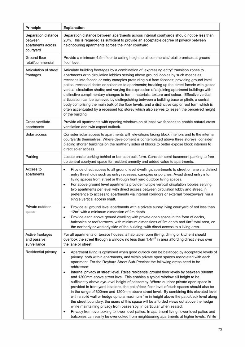
73
Principle Explanation
Separation distance between apartments across courtyard
Separation distance between apartments across internal courtyards should not be less than 20m. This is regarded as sufficient to provide an acceptable degree of privacy between neighbouring apartments across the inner courtyard.
Ground floor retail/commercial
Provide a minimum 4.5m floor to ceiling height to all commercial/retail premises at ground floor level.
Articulation of street frontages
Articulate building frontages by a combination of: expressing entry/ transition zones to apartments or to circulation lobbies serving above ground lobbies by such means as recesses into facade or entry canopies protruding out from facades; providing ground level patios, recessed decks or balconies to apartments; breaking up the street facade with glazed vertical circulation shafts; and varying the expression of adjoining apartment buildings with distinctive complimentary changes to form, materials, texture and colour. Effective vertical articulation can be achieved by distinguishing between a building base or plinth, a central body comprising the main bulk of the floor levels, and a distinctive cap or roof form which is often accentuated by a recessed top storey which also serves to lessen the perceived height of the building.
Cross ventilate apartments
Provide all apartments with opening windows on at least two facades to enable natural cross ventilation and twin aspect outlook.
Solar access Consider solar access to apartments with elevations facing block interiors and to the internal courtyards themselves. Where development is contemplated above three storeys, consider placing shorter buildings on the northerly sides of blocks to better expose block interiors to direct solar access.
Parking Locate onsite parking behind or beneath built form. Consider semi-basement parking to free up central courtyard space for resident amenity and added value to apartments.
Access to apartments
Provide direct access to all ground level dwellings/apartments to street or lane via distinct entry thresholds such as entry recesses, canopies or porches. Avoid direct entry into living spaces from street or through front yard outdoor living spaces.
For above ground level apartments provide multiple vertical circulation lobbies serving two apartments per level with direct access between circulation lobby and street, in preference to access to apartments via internal corridors or external ‘breezeways’ via a single vertical access shaft.
Private outdoor space
Provide all ground level apartments with a private sunny living courtyard of not less than 12m2 with a minimum dimension of 2m depth.
Provide each above ground dwelling with private open space in the form of decks, balconies or roof terraces, with minimum dimensions of 2m depth and 6m2 total area, on the northerly or westerly side of the building, with direct access to a living area.
Active frontages and passive surveillance
For all apartments or terrace houses, a habitable room (living, dining or kitchen) should overlook the street through a window no less than 1.4m2 in area affording direct views over the lane or street.
Residential privacy
Apartment living is optimised when good outlook can be balanced by acceptable levels of privacy, both within apartments, and within private open spaces associated with each apartment. For the Reyburn Street Sub-Precinct the following areas need to be addressed:
Internal privacy at street level. Raise residential ground floor levels by between 800mm and 1200mm above street level. This enables a typical window sill height to be sufficiently above eye-level height of passersby. Where outdoor private open space is provided in front yard locations, the patio/deck floor level of such spaces should also be in the range of 800mm and 1200mm above street level. By combining this elevated level with a solid wall or hedge up to a maximum 1m in height above the patio/deck level along the street boundary, the users of this space will be afforded views out above the hedge while maintaining privacy from passersby, in particular when seated.
Privacy from overlooking to lower level patios. In apartment living, lower level patios and balconies can easily be overlooked from neighbouring apartments at higher levels. While
74
it is impractical and not necessary to completely avoid such overlooking, it is a greater concern at closer proximities where a number of techniques can be deployed to address it, including: use solid balustrading to balconies above ground level; use pergolas, screens or canopies directly above the patio space to avoid overlooking from directly above; allow apartments on levels above the patio to overhang the patios thus creating a more private recessed zone within the patio; for patios overlooking the central courtyard space, provide semi-visually permeable screens between the patio and shared component of the courtyard, and set the patios above the level of the shared courtyard by not less than 700mm.
Privacy on upper level balconies/decks. Solid, or predominantly solid, balustrades encourage residents to use balconies as they afford users an acceptable level of privacy from public at close proximities while preserving views out. This can be balanced by strategic positioning of visually permeable areas of balustrading for key view shafts and views towards the water from living areas within apartments. Therefore a minimum of 70% solid/visually impermeable balustrading is recommended.
To provide for privacy between neighbouring balconies/decks/patios to adjoining apartments. Provide minimum 1.8m high screening between adjacent balconies/decks. These may taper back from the balustrade to full height at angels not greater than 40 degrees to the horizontal.
5.6.3. Access and Movement
The Hīhīaua Precinct is not connected to the Whangarei public transport bus network. The City Link Whangarei operates on a series of routes. The six bus routes include services to inner city suburbs. These include; Onerahi, Kamo/Tikipunga, Otangarei, Raumanga/Morningside and Maunu. As the Hīhīaua Precinct is not serviced by the bus network, employees or residents currently rely on their own cars to travel.
At present commercial businesses are utilising on-street parking and internal car parking facilities during the day for their commercial operations. District Plan provisions exempt all activities from providing minimum parking requirements in the majority of the Precinct (refer to Figure 29). Accordingly, new activities in the parking requirement exempt area do not have to provide a prescribed number of car parks rather parking requirements are based on market demand for the activity.
The Hīhīaua Precinct has a well laid-out grid roading pattern with wide streets. This roading pattern is suitable for redevelopment. Figure 53 illustrates the transport network showing access and intermodal movement for the Precinct. This is aligned with Council’s Walking and Cycling Strategy and Blue/Green Network. The road hierarchy differentiates roads by function. Arterial roads generally cater for through traffic and have higher traffic volumes whereas local roads provide direct access for residential or commercial uses.
The existing local road network will be retained. New connections through the central blocks are recommended to provide access to residential/commercial development. These are indicated as neighbourhood laneways but could also be classified as indicative future local roads. This new legible block structure will create a walkable environment and create a permeable built form suitable for residential development.
Shared space is proposed along Reyburn House Lane. This will assist to create a high amenity, pedestrian oriented environment in this location.
Land is underutilised particularly in inner city areas if required for on-site parking. Although the Precinct is exempt from parking requirements, guidance for high density residential living and mixed use development is recommended. Guidelines should encourage innovative approaches to parking. Innovative parking solutions and public transport options will assist to minimise on-street parking, potentially reduce impervious surfaces and utilise land more efficiently.

75
Figure 53 Indicative Transport Network
Consideration of parking demand, the public road network (off-site parking) and opportunities for concessions to minimise parking is needed. For example, shared parking provisions such as after hour’s commercial and residential sharing options would be suitable for a mixed use environment where there are day-centric activities and night-centric activities. Exempting visitor parking and/or one car-park per unit could be another method examined to manage parking in the Hīhīaua Precinct. Residential parking permits for fixed time periods (according to demand and the local context) if there is competing interest for car parks.
Semi-basement or basement car parking facilities will be dependent on the constructability of stable, water-tight walls within the soft dredge tailings and natural sediments that underlie the fill. However, if practicable compensated foundations, by including basement level(s) within a structure’s design, the weight of the building can be balanced against the weight of the soil removed and any hydrostatic uplift forces could geotechnical constraints (settlement can be minimized or eliminated) and car parking provided. Semi-basement and/or basement parking needs to be investigated for the specific site and may be challenging in the Precinct.
The transport environment in Whangarei is characterised by high usage of private vehicles. To encourage alternative transport options cycling infrastructure including on-road and off road lanes are proposed and it is recommended for new commercial buildings cycling and changing facilities (showers) should be required.
5.6.4. Open Space
Over the past 15 years, the Town Basin has undergone substantial change as part of Whangarei District Council’s ‘Sense of Place’ programme. A number of projects have taken place in the Town Basin vicinity to develop the area as a central social and recreational location. Two key projects along the Hatea River have transformed the waterfront area significantly.
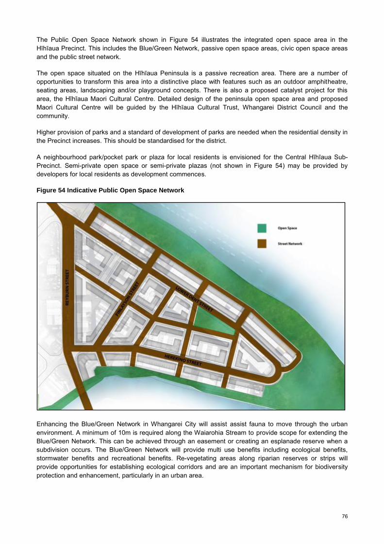
76
The Public Open Space Network shown in Figure 54 illustrates the integrated open space area in the Hīhīaua Precinct. This includes the Blue/Green Network, passive open space areas, civic open space areas and the public street network.
The open space situated on the Hīhīaua Peninsula is a passive recreation area. There are a number of opportunities to transform this area into a distinctive place with features such as an outdoor amphitheatre, seating areas, landscaping and/or playground concepts. There is also a proposed catalyst project for this area, the Hīhīaua Maori Cultural Centre. Detailed design of the peninsula open space area and proposed Maori Cultural Centre will be guided by the Hīhīaua Cultural Trust, Whangarei District Council and the community.
Higher provision of parks and a standard of development of parks are needed when the residential density in the Precinct increases. This should be standardised for the district.
A neighbourhood park/pocket park or plaza for local residents is envisioned for the Central Hīhīaua Sub-Precinct. Semi-private open space or semi-private plazas (not shown in Figure 54) may be provided by developers for local residents as development commences.
Figure 54 Indicative Public Open Space Network
Enhancing the Blue/Green Network in Whangarei City will assist assist fauna to move through the urban environment. A minimum of 10m is required along the Waiarohia Stream to provide scope for extending the Blue/Green Network. This can be achieved through an easement or creating an esplanade reserve when a subdivision occurs. The Blue/Green Network will provide multi use benefits including ecological benefits, stormwater benefits and recreational benefits. Re-vegetating areas along riparian reserves or strips will provide opportunities for establishing ecological corridors and are an important mechanism for biodiversity protection and enhancement, particularly in an urban area.

77
5.6.5. Community Facilities/Catalyst Projects
The Hīhīaua Precinct is emerging as a cultural hub with a growing cluster of amenities. The Northland Art Society (Reyburn House Studios), Whangarei Theatre Company (River Bank Theatre), Waka and Wave Sculpture, Heritage Trail and Art Walk are situated along the Hatea River waterfront. The Heritage Trail connects the Town Basin, adventure playground, art park, and ‘Waka and Wave’ Sculpture located at the end of the Hīhīaua Peninsula.
Investment in the wider area including, Te Matau ā Pohe Bridge, Town Basin adventure playground, Whangarei Aquatic Centre, the Victoria Canopy Bridge and seasonal Artisan Market on the Canopy Bridge have created a vibrant and attractive area. Current projects such as the Loop Walkway and the Car Park to Park project will promote the Hatea River waterfront area and make crucial connections to Whangarei City via a range of transport modes including, walking and cycling infrastructure.
Construction of the Loop Walkway around the Hatea River commenced in October 2013 and is programmed for completion in 2016. It will connect the Town Basin to surrounding amenities around the Hatea River and inner city area via a pedestrian bridge across the Waiarohia Stream to Port Road. The Car Park to Park project envisages the transformation of the informal car park area between the Market Bridge and Dent Street into a premium outdoor amenity park linking the CBD and the Town Basin. Council has had three concept plans drawn up, each offering a distinct set of options in terms of the activities and amenities on offer. Public engagement was undertaken for the three concepts.
Whangarei City has a unique historic and cultural heritage that is not always recognised nor fully celebrated. This includes both early Maori occupation and later European settlement. Future planning initiatives for the City need to contain strong heritage themes and strong land use planning and urban design provisions aimed at protecting and utilising Whangarei’s unique historic and cultural heritage. Redevelopment in the Hīhīaua Precinct needs to be mindful of the Town Basin’s colonial theme and enhance Maori cultural associations with the area. Fostering Maori culture and renaissance in the Precinct will improve amenity, sense of place and provide a unique attractiveness for residential living, hospitality and tourist type commercial development.
Proposed catalyst projects include the Hīhīaua Cultural Centre located at the end of Lower Dent Street, and the potential redevelopment of the old Northland Regional Council Harbour Board building at the Town Basin. These projects will enhance Whangarei District’s profile for cultural tourism and attract people to the district.
Figure 55 Proposed Hīhīaua Cultural Centre: Concept Drawing
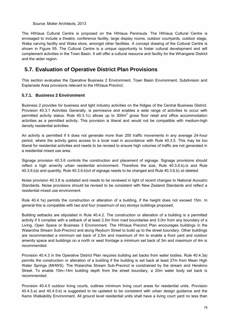
78
Source: Moller Architects, 2013
The Hīhīaua Cultural Centre is proposed on the Hīhīaua Peninsula. The Hīhīaua Cultural Centre is envisaged to include a theatre, conference facility, large display rooms, outdoor courtyards, outdoor stage, Waka carving facility and Waka store, amongst other facilities. A concept drawing of the Cultural Centre is shown in Figure 55. The Cultural Centre is a unique opportunity to foster cultural development and will complement activities in the Town Basin. It will offer a cultural resource and facility for the Whangarei District and the wider region.
5.7. Evaluation of Operative District Plan Provisions
This section evaluates the Operative Business 2 Environment, Town Basin Environment, Subdivision and Esplanade Area provisions relevant to the Hīhīaua Precinct.
5.7.1. Business 2 Environment
Business 2 provides for business and light industry activities on the fridges of the Central Business District. Provision 40.3.1 Activities Generally, is permissive and enables a wide range of activities to occur with permitted activity status. Rule 40.3.1c) allows up to 300m2 gross floor retail and office accommodation activities as a permitted activity. This provision is liberal and would not be compatible with medium-high density residential activities.
An activity is permitted if it does not generate more than 200 traffic movements in any average 24-hour period, where the activity gains access to a local road in accordance with Rule 40.3.5. This may be too liberal for residential activities and needs to be revised to ensure high volumes of traffic are not generated in a residential mixed use area.
Signage provision 40.3.6 controls the construction and placement of signage. Signage provisions should reflect a high amenity urban residential environment. Therefore the size, Rule 40.3.6.b).ix and Rule 40.3.6.b)x and quantity, Rule 40.3.6.b)vii of signage needs to be changed and Rule 40.3.6.b).xii deleted.
Noise provision 40.3.8 is outdated and needs to be reviewed in light of recent changes to National Acoustic Standards. Noise provisions should be revised to be consistent with New Zealand Standards and reflect a residential mixed use environment.
Rule 40.4.1a) permits the construction or alteration of a building, if the height does not exceed 15m. In general this is compatible with two and four (maximum of six) storeys buildings proposed.
Building setbacks are stipulated in Rule 40.4.2. The construction or alteration of a building is a permitted activity if it complies with a setback of at least 2.5m from road boundaries and 3.0m from any boundary of a Living, Open Space or Business 3 Environment. The Hīhīaua Precinct Plan encourages buildings in the Waiarohia Stream Sub-Precinct and along Reyburn Street to build up to the street boundary. Other buildings are recommended a minimum set back of 2.5m and maximum of 4m to enable a front yard and outdoor amenity space and buildings on a north or west frontage a minimum set back of 3m and maximum of 4m is recommended.
Provision 40.4.3 in the Operative District Plan requires building set backs from water bodies. Rule 40.4.3a) permits the construction or alteration of a building if the building is set back at least 27m from Mean High Water Springs (MHWS). The Waiarohia Stream Sub-Precinct is constrained by the stream and Herekino Street. To enable 10m–14m building depth from the street boundary, a 20m water body set back is recommended. Provision 40.4.5 outdoor living courts, outlines minimum living court areas for residential units. Provision 40.4.5.a) and 40.4.5.b) is suggested to be updated to be consistent with urban design guidance and the Kamo Walkability Environment. All ground level residential units shall have a living court yard no less than

79
12m2 with a minimum dimension of 2m depth and a residential unit above ground level 6m2 with a minimum dimension of 2m depth. Provision 40.4.7 requires the construction or alteration of a building or structure a minimum flood level of 2.5m above One Tree Point Datum Mean Sea Level 1964, as a permitted activity. It is advised District Plan Provisions are consistent with the Regional Policy Statement, subject to appeal and urban design guidelines.
5.7.2. Town Basin Environment
Chapter 43 Town Basin Environment provides for seven Sub-Environments, each limited in geographical area. Lower Dent Street Sub-Environment and Open Space Sub-Environment are located within the Hīhīaua Precinct. Refer to Figure 56. It was questioned during this review as to whether this fragmented approach is the most appropriate way for dealing with comprehensive development in the Town Basin. In addition, the boundary of the Town Basin Environment could be reviewed in light of new developments such as the Te Matau ā Pohe Bridge, the Loop Walkway and recreational development of Pohe Island.
Figure 56 Operative Whangarei District Plan Town Basin Sub-Environments
5.7.2.1. Town Basin Open Space Sub-Environment
In accordance with Rule 43.3.4 C) an activity in the Town Basin Open Space Sub-Environment is a permitted activity in accordance with an approved Reserve Management Plan under the Reserves Act 1977 or a Conservation Management Strategy under the Conservation Act 1987. There is no Reserve Management Plan relating to the Town Basin Open Space Sub Environment, therefore all activities are discretionary.
Provision 43.3.7 Fences enables the construction or alteration of a fence if it is within 2m of a boundary and no higher than 2m is a permitted activity. It is recommended 1m height is sufficient to demark ownership and define a given area, if required. This will enable public areas to be open and feel welcoming for the public.

80
Provision 43.3.9 Noise, is outdated and needs to be reviewed in light of recent changes to National Acoustic Standards (NZS 6801, NZS 6802 and NZS6803). Rule 43.3.9.c) limits temporary activities to 12 calendar days of every year in the Town Basin Environment. This provision needs to be amended to reflect a residential mixed use environment and determine an appropriate level of noise and number for events in this Environment.
Open Space policies in the Operative District Plan are very general and do not specify how the objectives will be achieved. Policy provisions indicate linkages between open space areas will be created. However, there is no detail in the Plan of what linkages have been achieved in order to identify or coordinate the missing links/connections. Detail of where strategic linkages should be made and how it is to be achieved is lacking in the Operative District Plan.
5.7.2.2. Lower Dent Street Sub-Environment
6.5.1 Regulatory Methods of the Operative District Plan identifies new rules for Town Basin Sub-Environments to enable and promote mixed use type developments. No guidance or incentives supporting innovative mixed use development currently exist. Urban intensification guidelines and revised rules would assist to promote Policy 26.11.1 and encourage residential mixed use development in the Lower Dent Street Sub-Environment.
In accordance with Rule 43.3.1.F).a) any activity is a permitted activity if permitted by the provisions of the Business 1 Environment (Rule 39.3) and the gross floor area at ground level does not exceed 300m2. This provision is permissive and allows activities to locate in this Environment which may be incompatible with residential uses, as a permitted activity.
An activity is permitted if it does not generate more than 200 traffic movements in any average 24-hour period, where the activity gains access to a local road in accordance with Rule 43.3.5. This may be too liberal for residential activities. To encourage a walkable pedestrian environment and ensure high volumes of traffic are managed this provision should be reviewed.
Provision 43.3.9 Noise, is outdated. Noise provisions need to be updated in light of changes to National Acoustic Standards (NZS 6801, NZS 6802 and NZS6803). These provisions should be revised to reflect a residential/mixed use environment.
Buildings in Lower Dent Street Sub-Environment are permitted if the height does not exceed 11m (Rule 43.4.1.F)a). The Precinct Plan has recommended two storeys, 8m along Reyburn House Lane and buildings along Lower Dent Street four storeys, 13.5m or 14.5m where semi-basement parking is provided. The proposed height reflects the local character, relationship with public open space and building typology.
Provision 43.4.2 Building Coverage permits the construction or alteration of a building if the total building coverage does not exceed 50% of any site. The building coverage in the Lower Dent Street Environment for most buildings is around 80-100%. This provision should be reviewed. Urban design guidelines, height provisions and/or permeable surface provisions, may be an effective method to protect the open space character and amenity of the environment. Permeable surfaces such as permeable paving, rain gardens and the like should be considered.
Provision 43.4.3 Building Setbacks permits the construction or alteration of a building as a permitted activity if the building is 3m from Living or Open Space Environment boundaries and setback at least 27m from MHWS. Building setbacks for buildings fronting Lower Dent Street may be required if they are residential activities. A minimum setback of 2.2m and maximum 4m setback is recommended from the road boundary.
Provision 43.4.6 requires the construction or alteration of a building or structure a minimum floor level of 2.5m above One Tree Point Datum Mean Sea Level 1964, as a permitted activity. It is advised District Plan Provisions are consistent with the Regional Policy Statement, subject to appeal and urban design guidelines.

81
Provision 43.5 Building and Development Style, refers to Appendix 7 of the Operative District Plan, which provides two design concepts for the Town Basin. The two concept plans are intended as a general guide for future development. The two Appendix 7 plans appear dated (2002) and their relevance (and that of clause 43.5) is therefore questioned. These concept plans are considered too general to be of much practical use and therefore should be removed from the Plan.
No specific rules or clear guidance on temporary activities exists. Provision 43.3.9 Noise and 43.6 Principal Reasons for Rules/Explanations – Noise, touches on temporary activities. Therefore, consent is frequently triggered by excess traffic movements or noise. Given the increased usage of the Town Basin area for temporary activities such as markets and other events, a review of the issue is recommended.
5.7.3. Esplanade Reserve Rules
Chapter 61 Esplanade Reserve Resource Area Rules outlines rules relating to the coastal environment or a river, and includes areas identified as an Esplanade Priority Area.
The Hīhīaua Precinct is bounded by the coast. Rule 61.3.1 outlines subdivision as a controlled activity if where any allotment of less than 4.0 ha in area is created, an esplanade reserve or esplanade strip of a minimum of 20.0 m in width is provided. It is recommended a 10m wide esplanade reserve or strip along the Waiarohia Stream should be established to provide public access and recreational use. Under s230 of the Resource Management Act 1991 (RMA), an esplanade reserve or esplanade strip can be taken for one or more of the purposes of s229 of the RMA, including protection of conservation values, provision of public access, or provision of recreational use (that is compatible with the conservation values) when privately owned land is subdivided. In accordance with section 77(1) of the RMA this provision should be changed to provide a 10m esplanade reserve or strip for this location.
5.7.4. Subdivision Rules
Chapter 74 Subdivision Rules covers Business 1, 2, 3, 4, Town Basin, Marsden Point Port, Port Nikau, and Airport Environments. Subdivision is a controlled activity subject to; allotment area, allotment shape, allotment frontage, existing buildings, Sites of Significance to Maori, property access, road and cycle layout and formation, street lighting, earthworks, infrastructure and telecommunication service provisions.
5.8. Land Use Rezoning and Redevelopment Programme
The Hīhīaua Precinct Plan will inform changes to zoning in the Operative District Plan. It is recommended a plan change is initiated to create a new Residential Mixed Use Environment and replace existing zoning and provisions for the Precinct. The Hīhīaua Precinct Plan provides a framework for provisions, detailing design outcomes and specific development controls and assessment criteria for the Sub-Precinct areas.
Three options were assessed, ‘do nothing’, rezone the Hatea River Sub-Precinct to Residential Mixed Use, by way of plan change and rezone the Hīhīaua Precinct Plan to Residential Mixed Use, by way of plan change (see Section 5.5). In summary, initiating a plan change to rezone the Hīhīaua Precinct to Residential Mixed Use Environment was deemed the most effective and efficient approach to manage reverse sensitivity effects, achieve urban intensification, good urban form and encourage comprehensive development.
The Residential Mixed Use Environment (or Hīhīaua Mixed Use Environment) will outline an appropriate ‘mix’ of activities compatible with medium/high density residential activities. The Residential Mixed Use Environment will have strong policies to guide development to achieve the intended design outcomes envisioned for this area. Policy references to the Hīhīaua Precinct Plan, design guidance within the Hīhīaua Precinct Plan and Council’s Intensification Guidelines will strengthen provisions and reinforce a design-led approach for new development.

82
A plan change for the Hīhīaua Precinct will not just facilitate residential and mixed use development but prevent development that may compromise what is envisioned in the Precinct Plan. Inappropriate development or the expansion of existing activities if not aligned with the Hīhīaua Precinct Plan should be avoided. Expanding and prospective industrial activities will be prohibited. New or expanding commercial activities need to be evaluated against the relevant provisions and intermediary lease agreements may need to be negotiated until redevelopment takes place.
A plan change for the Precinct will promote a coordinated development approach and ensure the envisaged development potential is fully utilised along with high quality urban design. The staging/phasing or sequencing development in the Precinct will be guided by the Hīhīaua Precinct Redevelopment Programme. The development programme will enable Council to indicate to the public and private developers the location and timing of redevelopment to focus effort in securing leases and/or land and prioritise needed infrastructure such as public domain upgrade/improvements including road laneways and parks. The land owners (Whangarei District Council and Northland Regional Council) are in a position to work with private developers to ensure coordinated and comprehensive development rather than ad hoc development. Over time, the prioritisation or recommended staging may vary as private investment or land owner preference may quicken the pace of redevelopment. The staging programme must be robust but flexible and above all promote comprehensive, coordinated development, aligned with the Precinct Plan.
5.8.1. Indicative District Plan Provisions
It is recommended the Town Basin Environment (Lower Dent Street Sub Environment) and Business 2 Environment is replaced with a new Hīhīaua Mixed Use Environment, by way of plan change. Refer to Figure 57. The Hīhīaua Mixed Use Environment will provide for medium/high density residential activity, community activities, recreation activities, tourist-related activities and small scale appropriate commercial uses such as office and retail activity. Refer to Table 5.
Table 5 Activities Generally Envisioned
Activities Generally
Hatea River Sub-Precinct Medium/high density residential activities, tourist related activities, entertainment facilities including boutique cinema, bars, theatres and concert facilities, community facilities such as healthcare facilities, commercial activities including cafes, restaurants, dairy, retail and office activities.Building heights should be between two and three (up to a maximum of four) storeys.
Waiarohia Stream Sub-Precinct Medium/high density residential activities, community facilities such as education facilities, office/retail accessory activities to residential activities or home occupation. Building heights should be between two to three storeys and on the corner of Herekino and Reyburn Streets two to four (maximum of six storeys).
Central Sub-Precinct Medium/high density residential activities, small scale commercial and office activities, larger scale projects such as a hotel or retirement facility. Building heights should be between two to four (maximum of six) storeys.
Reyburn Street Sub-Precinct Medium/high density residential activities, entertainment facilities, community facilities, commercial activities including offices and retail. Building heights should be between two to four (maximum of six) storeys.
The Hīhīaua Mixed Use Environment will include associated provisions for activities generally, building height, building setbacks, impervious surface controls, noise, traffic movements, lighting, signage, building daylight angles, outdoor living courts/verandahs, yards, landscaping, building frontage provisions, minimum dwelling size, daylight to dwelling, dwelling mix, outlook space, maximum building length and depth amongst other development controls.

83
Figure 57 Proposed Landuse Zoning
The Open Space Environment will be reviewed with the district wide rolling review of open space. It is recommended land shown in Figure 57 in green is used for civic open space and passive recreation. A 10m wide area along the Waiarohia Stream is recommended for recreation, public access, cycling and walking infrastructure and to extend the Blue/Green Network.
It is recommended the Hīhīaua Mixed Use Environment recognizes the Precinct Plan and Sub-Precincts. The Central Hīhīaua Sub-Precinct and Reyburn Street Sub-Precinct may be combined as they share similar geographical and roading characteristics and anticipate alike development. Provisions to enable staged/phased implementation of the Precinct Plan to manage development, encourage good urban design, and avoid ad hoc sporadic development and the release of land in a practicable manner is required. District Plan methods may include provisions to trigger the next stage of development for example, a percentage of land should be redeveloped before development commences in another area.
Urban design provisions or guidance are essential to ensure good urban design outcomes are achieved in the Hīhīaua Precinct. Operative District Plan provisions at present do not cover design expectations including urban amenity and/or relationship to urban context. It is becoming widely accepted that adherence to land use rules alone cannot be relied upon to deliver high design standards. Council is developing Intensification Guidelines which will set up design principles and good practice techniques. It is recommended, wherever practicable, references to the Guidelines are made. The Built Form and Design Guidelines contained in the Hīhīaua Precinct Plan should also be applied to all future development in the Precinct and linked to provisions in the Hīhīaua Mixed Use Environment.
The Operative Whangarei District Plan is currently under review. A fundamental change to place more emphasis on policies and objectives rather than specific rules will shift emphasis when evaluating applications from meeting quantifiable rules to meeting the intent of the policies and objectives. A mechanism in the District Plan for applications to be reviewed by the Urban Design Panel for non-notification

84
should be examined. For applications where the outcome in urban design terms is deemed of significance, it is proposed that an application could only proceed non-notified with either an Urban Design Panel report or a full section 32 analysis. Examples of applications that would fall into this category would likely include mixed use development, multi-unit housing, larger scale retail development and any other development with potentially significant effects. As the Panel option would offer the path of least cost to an applicant, it is likely there would be strong uptake. Also, as the Panel review can, and ideally should, precede consent lodgement, the applicant could use the process to gauge whether their proposal would be successful at an early stage, before becoming heavily committed.
An application to the Panel is in all cases voluntary. Urban design panels fall outside the statutory provisions of the RMA and therefore cannot in themselves determine the outcomes of resource consent applications. The Panel would produce a report that states either: support, non-support or deferment (which means Panel support is provisional on amending the proposal in accordance with recommendations set out in the report, and resubmitting to the Panel). Should the Panel endorse an application, it would have a bearing on the application proceeding non-notified and therefore incentivise better design outcomes.
Council’s discretion for applications needs to relate to design expectations, urban amenity and/or relationship to urban context. These areas are not covered by easily quantifiable District Plan provisions such as bulk and location rules and it is becoming widely accepted that adherence to rules alone cannot be relied on to deliver high design standards. A Panel offers a means of providing a high level, specialised and objective assessment of design proposals, where the Panel’s recommendations go on to assume the status of expert opinion at consent stage.
85
6. Part F: Implementation and Monitoring
6.1. Implementation
The Hīhīaua Precinct Plan outlines Council’s strategic direction to manage growth and development in the Precinct for the next 20/30 years. The Hīhīaua Precinct Plan has taken strategies and plans adopted by Council, including the Whangarei District Growth Strategy: Sustainable Futures 30/50, 20/20 Plus CBD Guideline Development Plan, Urban Growth Strategy, Urban Design Strategy, Parking Strategy, Open Space Strategy, Walking and Cycling Strategy and District Plan into consideration in developing the ‘blueprint’ for this area.
Precinct planning is a tool to facilitate a precinct’s development potential and coordinate efficient delivery of key infrastructure and community services. The precise timing of redevelopment is unknown, however, it is envisaged that it will be progressively implemented over the next 20/30 year period through partnerships between the public and private sectors, community groups, business owners and landowners/councils and as development in other parts of the city creates new opportunities.
A large number of the properties, along with their lease agreements, have been inherited by the district and regional councils from the previous Harbour Board. Perpetual lease agreements, along side ad hoc residential development, may discourage comprehensive development opportunities in the initial stages. Market feasibility for intensive residential development and mixed use is little tested in the district; however, public support through previous consultation on inner city living, has indicated there is market demand for inner city living in this location.
Redevelopment can occur, and is presently occurring in an ad hoc fashion under Operative District Plan provisions. This will, over time, undermine the potential for the outcome set out in this document to be realised. Therefore, a strategic approach is required to enable comprehensive development and introduce mechanisms to better coordinate development over the medium to long term. Timing the release of land and phasing development in the Precinct is critical to managing existing and future residential uses in the Hīhīaua Precinct.
As opportunities arise, Council should continue to undertake incremental improvements to the public realm, like street improvements, art sculptures and seating. This will assist to promote arts, cultural and tourism development, and improve pedestrian safety and connectivity. Other initiatives include the loop walkway; the Hīhīaua Cultural Centre programmed indicatively for 2018; Blue/Green Network initiatives and the potential redevelopment of the old Northland Regional Council Harbour Board building, which are all drivers for redevelopment opportunities.
There are a number of projects that could be delivered relatively quickly and others which will take longer. The Hīhīaua Cultural Centre will be a major catalyst project in the Hīhīaua Precinct. When completed it is expected to change the environment considerably. If the old Northland Regional Council Harbour Board building is redeveloped as an iconic space, this may also be a major influence on the future development of the area, including the Hīhīaua Precinct. Land values in the Hīhīaua Precinct are expected to rise significantly if both catalyst projects proceed. Over time it is expected that light industrial activities will move to other location(s) in Whangarei and vacant buildings will be able to convert to alternative uses. A plan change may influence this as a result of the underlying effect on land values and potential returns on development.
The Blue/Green Network would provide ecological benefits and provide public access along the water’s edge. The Walking and Cycling Network along the Hatea River and Waiarohia Stream will connect this area to the City and create an attractive environment, building a safe and high quality network for pedestrians and cyclists.

86
6.2. Hīhīaua Precinct Redevelopment Programme
The Hīhīaua Precinct Plan outlines the spatial location, configuration and orientation of buildings, land use activities, building height, street network, and open space network. The Precinct Plan provides a framework for introducing mixed use and residential activities in the Hīhīaua Precinct, by way of a change to the District Plan. The plan change will introduce a Residential Mixed Use Zone or overlay for the Precinct to allow for medium/high density residential activities and compatible mixed use activities. A policy and design led new zone/overlay will ensure development is guided by good urban design.
There are a number of factors affecting the release of land to enable redevelopment, including lease agreements/available land, commercial activities relocating, market demand, population growth and the delivery of key infrastructure and services. The completion of catalyst projects in the vicinity will also affect demand. Land should therefore be released for redevelopment in a practicable manner that does not compromise future redevelopment opportunities and enables existing activities to continue in the short to medium term.
Strong consideration should be given to amalgamating sites should the opportunity arise. Amalgamating existing lots will optimise residential development opportunities and enable comprehensive development options critical to the success of transitioning from a light industrial/commercial development pattern to a suitable residential mixed use development pattern. Development, particularly within the Sub-Precincts, should adopt a coordinated approach. When development commences, the corner lot and adjoining lots could be developed in conjunction initially or a certain minimum number of lots along a frontage could be developed. It is preferred that a block or semi-block is redeveloped concurrently. If it is not possible to obtain the whole area, development of 2000m2, or greater, could be developed paying careful attention to how development will integrate with adjacent existing and future development.
Thus, redevelopment proposals should demonstrate how they are integrating, or how future development proposals will integrate, with the surrounding activities and development. This will help ensure that the built pattern and layout of development is guided by good urban design principles and encourages future residential uses. While it doesn’t need to be the same developer, the development needs to be integrated. This can be quite a challenge with uneven development demand and long lead-in times. If someone wants to build their own terrace house within any part of the development, consideration is needed to ensure the proposal is integrated with existing and future development scenarios. This could be achieved through requisite policies which would require compliance with the layout, orientation and development pattern of sites.
Key to the success of introducing high quality residential uses in an existing area is a guided building (settlement) pattern and building typology for each Sub-Precinct. This will enable development to be integrated and give effect to existing and future development in a controlled way. The Precinct Plan acknowledges that redevelopment of the Central Hīhīaua Sub-Precinct and Reyburn Street Sub-Precinct may look different, should the block structure be reconfigured for a different housing typology such as terraced housing. However, a design-led approach for the Hīhīaua Precinct, to achieve residential/mixed use development, is vital. Private developers may devise an alternative development plan for a block or area ahead of the timing schedule. In this case, developers will be able to utilise the Management Plan Technique available in the Whangarei District Plan or land may be released ahead of the Hīhīaua Precinct Redevelopment Programme if aligned with the overall strategy and outcomes envisaged in the Precinct Plan.
In order to enhance the built environment of the Hīhīaua Precinct, all new buildings and alterations to existing buildings, will require a resource consent and will have to meet a range of urban design focused development controls and assessment criteria. Development controls and assessment criteria will include controls such as setbacks for the upper storeys of buildings, controls on street and lower level activities and the frontage of buildings, for example.
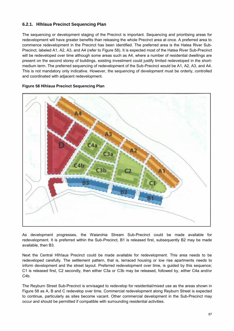
87
6.2.1. Hīhīaua Precinct Sequencing Plan
The sequencing or development staging of the Precinct is important. Sequencing and prioritising areas for redevelopment will have greater benefits than releasing the whole Precinct area at once. A preferred area to commence redevelopment in the Precinct has been identified. The preferred area is the Hatea River Sub-Precinct, labeled A1, A2, A3, and A4 (refer to Figure 58). It is expected most of the Hatea River Sub-Precinct will be redeveloped over time although some areas such as A4, where a number of residential dwellings are present on the second storey of buildings, existing investment could justify limited redeveloped in the short-medium term. The preferred sequencing of redevelopment of the Sub-Precinct would be A1, A2, A3, and A4. This is not mandatory only indicative. However, the sequencing of development must be orderly, controlled and coordinated with adjacent redevelopment.
Figure 58 Hīhīaua Precinct Sequencing Plan
As development progresses, the Waiarohia Stream Sub-Precinct could be made available for redevelopment. It is preferred within the Sub-Precinct, B1 is released first, subsequently B2 may be made available, then B3.
Next the Central Hīhīaua Precinct could be made available for redevelopment. This area needs to be redeveloped carefully. The settlement pattern, that is, terraced housing or low rise apartments needs to inform development and the street layout. Preferred redevelopment over time, is guided by this sequence; C1 is released first, C2 secondly, then either C3a or C3b may be released, followed by, either C4a and/or C4b.
The Reyburn Street Sub-Precinct is envisaged to redevelop for residential/mixed use as the areas shown in Figure 58 as A, B and C redevelop over time. Commercial redevelopment along Reyburn Street is expected to continue, particularly as sites become vacant. Other commercial development in the Sub-Precinct may occur and should be permitted if compatible with surrounding residential activities.

88
This sequencing approach aims to alleviate reverse sensitivity issues and create a pattern of development which will create a high amenity public realm. Identifying priority areas was deemed to be the most suitable method to sequence development to mitigate environmental effects, reverse sensitivity issues and create a residential mixed use area that embodies good urban design principles. This area will experience less interference from commercial through traffic and a high quality residential enclave area could be established.
The sequencing plan provides a strategic approach to assist in the long term delivery of development and key infrastructure (roads/parks) to be coordinated in an efficient and effective way. This sequencing plan will enable the delivery of essential infrastructure such as neighbourhood laneways, access ways, public open space and infrastructural requirements or upgrades (such as stormwater, wastewater, and potable water) in the Precinct to be coordinated with development.
The preferred sequencing programme is flexible. Any out of sequence development will be considered if it fits in with the future development outcomes outlined in the Hīhīaua Precinct Plan. Out of sequence development can be scrutinized through the Management Plan provisions in the District Plan. The Management Plan Technique is an existing tool in the District Plan which facilitates subdivision and development in a flexible yet controlled way.
6.3. Relocation of Existing Activities in the Hīhīaua Precinct
Promoting the relocation of existing light industrial activities to alternative locations will help enable redevelopment opportunities to arise over time. Bayleys Research found new development in the industrial sector has been slow in recent years with activity in this sector being focused on design builds for existing businesses or businesses wanting to relocate to alternative premises (Bayleys Research, 2013). A recent shift of commercial activities in Central Whangarei has changed the nature of commercial land, for example, car yards near the Town Basin locating to Porowini Avenue and Port Road. The relocation of the major car dealerships has created a new opportunity to redevelop these key sites located on the fringe of the Hīhīaua Precinct.
Council recognises there is a wide range of commercial and light industrial activities in the Precinct. With a change of land use to residential activities (and compatible other uses), existing light industrial and some commercial activities in the Hīhīaua Precinct, are likely to relocate to alternative sites. The timing of relocating businesses will need to be taken into account in redevelopment plans. There are a number of factors influencing the location of businesses. These include; historical factors, convenience, personal preferences, economic imperatives, and lastly visibility/location. For example, historic reasons could be tied to the geographical location of an activity such as access to water for marine activities. Convenience may be driven by a business locating in a site to benefit the customer. Personal preferences may include, personal/behavioural reasons such as where the owner lives or area of town the person likes. Economic cost, cheap land and/or lease may encourage a business to operate in that specific location. Lastly, visibility either from pedestrian and/or vehicle traffic, depending on the activity may have an influence. Some businesses locate in a particular area to get exposure from high vehicular traffic such as on an arterial road or in the central business district to capitalise on higher volumes of walking traffic. These factors influence the decision making process of where a businesses/activity will locate.
There are a number of other factors that may encourage light industrial and commercial activities on the Hīhīaua Precinct to relocate. Council believes the proposed Hīhīaua Cultural Centre, the potential redevelopment of the old Northland Regional Council Harbour Board building, and a change of land use promoting medium density residential activities will motivate the relocation of commercial and light industrial activities. Firstly, the Cultural Centre will change the ambience of the Peninsula. We would expect traffic patterns to change and thus activities dependent on exposure from traffic may relocate. We would expect the value of land (and hence leases) to increase once the land is rezoned. In turn, this may affect businesses operating in the Precinct, which were previously located on inexpensive commercial leases/land. Available public car parking areas and street parking may not be as easily accessible for commercial premises. The Town Basin and amenities in the Hīhīaua Precinct are attracting more people and available car parking

89
areas may have competition with more tourists visiting the area. It is expected tourism, arts and cultural activities will be attracted to this area, changing the nature of the Precinct.
We expect rezoning the land will influence the economic feasibility of some businesses. In Whangarei, there is sufficient light industrial land currently zoned to accommodate light industrial or commercial activities to relocate. Plan Change 104 in 2008, zoned 21 hectares of Business 2 land on Pipiwai Road in Springs Flat which is situated north of Kamo. In addition, a Private Plan Change in 2006 zoned 35 hectares of Business 2 land on Gumdigger Place, near Rewarewa Road, south of Whangarei. Existing light industrial areas around the edge of Whangarei combined with these two greenfield sites zoned Business 2, will enable light industrial activities in the Hīhīaua Precinct to relocate without further rezoning being required.
Additionally, the nearby Port Nikau Environment provides for light industrial activities and residential mixed use activities. Approximately 88 hectares of land is zoned ‘Port Nikau Environment’. Port Nikau has deep water access and access to three wharves. This location may be appropriate for marine, boat building or other businesses wanting access to Whangarei, its Harbour, and/or State Highway 1.
6.4. Monitoring and Review
It is anticipated that this document will require review every five years from adoption, subject to the rate of development. Changes to the Precinct Plan may be required to take account of market realities and updates to the Precinct Plan may be required over time.
90
Reference List
Archifact Limited and Littoralis Landscape Architecture. 2005. Whangarei District Urban Growth Strategy- Landscape and Urban Identity Assessment: City Study Area. Prepared for Whangarei District Council.
Baileys Research. 2013. Market Beat-Whangarei Commercial and Industrial. Bailey Real Estate Ltd, Whangarei.
Mckay. 2013. Lower Hatea River Crossing. Retrieved 16 September 2013 from http://www.mckay.co.nz/home/?p=453
Ministry for the Environment. 2012. Users Guide National Environmental Standard for Assessing and Managing Contaminants in Soil to Protect Human Health. Ministry for the Environment, Wellington.
Moller Architects. 2010. Hīhīaua Cultural Centre. Retrieved 28 May 2013 from http://mollerarchtects.blogspot.com/2010/01/Hīhīaua -cultural-centre.html
Northland Society of Arts. 2013. Historic Reyburn House. Retrieved 10 July 2013 from http://reyburnhouse.co.nz/reyburn-house/
Northland Regional Council. 2013. Whangarei City 100Yr Flooding Model. Northland Regional Council, Whangarei.
Northland Regional Council. 2013. Mangroves. Retrieved 20 May 2013 from http://www.nrc.govt.nz/For-Schools/School-information-packs/Mangroves/
Northland Regional Council and Whangarei District Council. 2012. Whangarei Harbour Water Quality Action Plan. Northland Regional Council, Whangarei.
Northland Regional Council. 2004. Regional Water and Soil Plan. Northland Regional Council, Whangarei.
Northland Regional Council. 2003. Regional Coastal Plan. Northland Regional Council, Whangarei.
Northland Society of Arts. 2013. Reyburn House. Retrieved 10 June 2013 from http://reyburnhouse.co.nz/reyburn-house/
Parks, W. F. 1992. Guide to Whangarei City and District. Rossiter Printing, Whangarei.
Richard, S. 2001 Engineering Report; New Building for F Gibson, Unpublished Report, Whangarei.
Rust, A. M. 2005. Whangarei and districts’ early reminiscences. Mirror Printing and Publishing, Wellington.
Ringer, M. and Munro, T. 2010a. European History Heritage Boards at the Town Basin. Whangarei District Council, Whangarei.
Ringer, M. and Munro, T. 2010b. Maori History Heritage Boards at the Town Basin. Whangarei District Council, Whangarei.
Tonkin and Taylor Ltd. 2014. Geotechnical Assessment of the Hīhīaua Precinct Plan. Prepared for Whangarei District Council. Tonkin and Taylor Ltd, Auckland.
Tonkin and Taylor Ltd. 2008. Land Zonation Mapping Geotechnical assessment level/stability hazard mapping for Hikurangi, Mid Kensington, Whangarei City Centre, East Kamo & Portland: Volume 1. Prepared for Whangarei District Council. Tonkin and Taylor Ltd, Whangarei.

91
Tonkin and Taylor Ltd. 1978. Hīhīaua Subdivision – Soil Investigation for Remaining Stages. Report prepared for Northland Harbour Board. Tonkin and Taylor Ltd, Whangarei.
Tonkin and Taylor Ltd. 1970. Hīhīaua Subdivision Investigation Settlements. Report prepared for Northland Harbour Board. Tonkin and Taylor Ltd, Whangarei.
URS New Zealand LTD. 2006 Whangarei CBD Flood Management Study: Flood Damage Assessment. Prepared for Whangarei District Council.
URS New Zealand LTD. 2006a. Flood Mapping Extents 100 Year: Future Climate Change. Prepared for Whangarei District Council.
Whangarei District Council. 2013. Whangarei City Land Use Survey. Whangarei District Council, Whangarei.
Whangarei District Council and Reset Urban Design. 2012. Whangarei 20/20 Momentum: Strategic Projects for the next 12 years. Whangarei District Council, Whangarei.
Whangarei District Council. 2012a Is our District Plan working after 5 years in operation? A report on the efficiency and effectiveness of objectives, policies and other methods in the Operative Whangarei District Plan. Whangarei District Council, Whangarei.
Whangarei District Council. 2012b. Biodiversity Strategy Whangarei. Whangarei District Council, Whangarei.
Whangarei District Council. 2012c. Walking and Cycling Strategy. Whangarei District Council, Whangarei.
Whangarei District Council. 2010a. Whangarei District Growth Strategy: Sustainable Futures 30/50. Whangarei District Council, Whangarei.
Whangarei District Council. 2010b. Sense of Place: Urban Design, Amenity, Local Character and Heritage. Whangarei District Council, Whangarei.
Whangarei District Council. 2011. Parking Management Strategy. Whangarei District Council, Whangarei.
Whangarei District Council. 2007. Operative Whangarei District Plan. Whangarei District Council, Whangarei.
Whangarei District Council, Isthmus Group, Littoralis Landscape Architecture, and Traffic Design Group. 2006. Whangarei 20/20 Plus: CBD Guideline Development Plan. Whangarei District Council, Whangarei.
Whangarei District Council. 2003. Whangarei Urban Growth Strategy. Whangarei District Council, Whangarei.
Whangarei District Council. 2001. Open Space Strategy. Whangarei District Council, Whangarei.
White, P.J. and Perrin, N.D. 2003. Geology of the Whangarei Urban Area, Institute of Geological and Nuclear Sciences,1171-9168; 26.

92
Appendix 1: Geotechnical Assessment Hīhīaua Precinct Plan, by
Tonkin and Taylor

REPORT
Report prepared for:
Whangarei District Council
Report prepared by:
Tonkin & Taylor Ltd
Distribution:
Whangarei District Council 1 copy
Tonkin & Taylor Ltd (FILE) 1 copy
February 2014
T&T Ref: 29765
Whangarei District Council
Geotechnical Assessment
Hihiaua Precinct Plan

Geotechnical Advice Hihiaua Precinct Plan Job no. 29765
Whangarei District Council Feb 2014
Table of contents
1 Introduction 1
2 Scope of work 2
3 Site description 3
4 Geotechnical conditions 8
5 Potential for redevelopment 11
5.1 General 11
5.2 Geotechnical limitations 11
5.2.1 Settlement 11
5.2.2 Liquefaction and lateral spread 11
5.2.3 Climate change and sea level rise 12
5.3 Assessment of Potential Structures 13
5.3.1 Medium-rise apartments 13
5.3.2 Low-rise apartments and terrace housing 14
5.3.3 Basement and semi-basement car parking 14
5.3.4 Work/Live units 14
6 Discussion and Conclusions 15
7 References 16
8 Applicability 17
Geotechnical Advice Hihiaua Precinct Plan Job no. 29765
Whangarei District Council Feb 2014
Executive summary
The Hihiaua Peninsula is a triangular parcel of land located at the confluence of the Hatea River
and the Waiarohia Canal in Whangarei City. The peninsula was largely formed in the mid-1960’s
and early 1970’s by reclamation works carried out by the Northland Harbour Board. The upper
peninsula is currently utilised as a light industrial and commercial area with the remainder
consisting of open parkland.
Whangarei District Council (WDC) is currently preparing a Precinct Plan for the Hihiaua Peninsula
which proposes a change of land use to residential/mixed use activities. As a consequence, the
range of building types that could be constructed within the precinct potentially includes the
following:
· Low-rise apartments (two to three storeys);
· Medium-rise apartments (up to 6 storeys);
· Terrace housing;
· Work/live units
WDC have commissioned Tonkin & Taylor Ltd (T&T) to undertake a desktop geotechnical
assessment of the Hihiaua Peninsula with the aim of providing advice on the overall suitability
of the area for the proposed redevelopment.
The relatively recent formation of the Hihiaua Peninsula through hydraulic filling means that the
area is susceptible to load-induced settlement. This hazard has been managed to date by
restricting building heights and foundation loads. The construction of buildings that are
significantly larger than those built to date can be expected to induce potentially significant
settlements within the soft compressible soils that underlie the site. A range of options exist for
mitigating the settlement hazard, including piled foundations, compensated foundations or
ground improvement. Each of these can be assessed on their merit for each project as well as
the potential impact on adjacent properties.
The construction of basements or semi-basements in the soft sediments and high (shallow)
groundwater table that characterises the site is likely to be challenging. We believe however
that these issues can be mitigated through standard construction techniques. One significant
hazard associated with the construction of basements within saturated, poorly consolidated
soils is dewatering-induced ground settlement. This may not only affect the building being
constructed but may adversely affect nearby buildings and infrastructure. Developments with
basements are likely to require a higher than usual level of geotechnical design, construction
supervision and mitigation planning as there is an elevated risk of excavations affecting
neighbouring properties.
Although seismic analyses have not been undertaken as part of this desktop study, we believe
that under seismic conditions, a significant portion of the peninsula could be affected by
liquefaction and possibly lateral spread. Experience from both New Zealand and overseas has
shown that coastal areas formed by reclamation are particularly susceptible to liquefaction and
lateral spreading as a result of seismic shaking. These seismic effects would need to be assessed
as part of any future development in the area. The seismic hazards and possible mitigation
options would require site specific assessment and design for redeveloped properties.
Based on current government advice on climate change and sea level rise, it is expected that
both static groundwater and surface water (streams) could come within 0.5m to 1.0m of the
current ground surface by 2099. Such an increase in water levels, depending on the magnitude
of rise and the timeframes being considered, increase the potential for inundation or flooding
across the peninsula. Future developments may need to consider increases in ground level (by
Geotechnical Advice Hihiaua Precinct Plan Job no. 29765
Whangarei District Council Feb 2014
filling) or an increase in ground floor elevations. Increased groundwater levels also have direct
implications for the challenges associated with the construction of excavations, foundations and
infrastructure. An increase in the elevation of groundwater also results in a corresponding
increase in susceptibility to liquefaction and possibly lateral spreading.
In summary, the proposed redevelopment of the Hihiaua Peninsula has significant geotechnical
challenges. Under static conditions, high groundwater, soft soil excavation and ground
settlement risks associated with dewatering can be mitigated with conventional, although
potentially more expensive solutions. These would require site-specific design. Seismic
liquefaction and lateral spreading are issues commonly associated with geotechnical settings
such as this and will need to be considered when assessing development options for the
peninsula.
1
Geotechnical Advice Hihiaua Precinct Plan Job no. 29765
Whangarei District Council Feb 2014
1 Introduction
The Hihiaua Peninsula is a triangular parcel of land located at the confluence of the Hatea River and
the Waiarohia Canal1 in Whangarei City. It was largely formed in the mid-1960’s and early 1970’s
by reclamation works carried out by the Northland Harbour Board. The upper peninsula is currently
utilised as a light industrial and commercial area occupied by one or two storey buildings. The
remainder of the peninsula consists of open parkland.
Whangarei District Council (WDC) is currently preparing a Precinct Plan for the Hihiaua Peninsula.
The plan proposes a change of land use from light industrial and commercial to residential/mixed
use activities. As a consequence, the range of building types that could be constructed within the
precinct may include the following:
· Low-rise apartments (two to three storeys);
· Medium-rise apartments (up to 6 storeys);
· Basement or semi-basement parking;
· Terrace housing;
· Work/live units.
WDC have commissioned Tonkin & Taylor Ltd (T&T) to undertake a desktop geotechnical
assessment of the Hihiaua Precinct with the aim of providing advice on the overall suitability of the
area for the proposed land use changes.
This report summarises the development of the peninsula, develops a general geotechnical model
for the area and presents an assessment as to how local ground conditions could potentially affect
the potential redevelopment of the area.
1 Also referred to as the Waiarohia Stream

2
Geotechnical Advice Hihiaua Precinct Plan Job no. 29765
Whangarei District Council Feb 2014
2 Scope of work
The scope of work for this assessment, outlined in our proposal (Ref 29765) dated 11 December
2013, consisted of the following:
· Review T&T’s database of projects to identify previous relevant work;
· Collate geotechnical data currently held by T&T and WDC for the Hihiaua Precinct;
· Develop a ground model for the Hihiaua Precinct, including:
- The extent of available information
- Major stratigraphic units
- Groundwater levels
- Potential geotechnical risks and limitations/requirements for foundations etc.
· Preparation of a technical report which summaries the information described above
together with an assessment of how the geotechnical conditions may materially affect the
potential redevelopment of the area.

3
Geotechnical Advice Hihiaua Precinct Plan Job no. 29765
Whangarei District Council Feb 2014
3 Site description
The Hihiaua Peninsula is located in central Whangarei City at the confluence of the Hatea River and
Waiarohia Canal. An annotated aerial photograph of the peninsula is presented as Figure 1. The
peninsula is a largely artificial construct with the original low-lying to intertidal location having been
built up in 1966 with some 2m of pumped dredge tailings (T&T, 1970). Additional imported fill was
placed over the dredge tailings during the late 1960’s and early 1970’s. Only some of this fill appears
to have been engineered (T&T, 1978). The final phase of the precinct’s development was the
progressive placement of temporary fill across individual development blocks as preload. The
purpose of the preload was to induce consolidation within the underlying compressible soils prior
to the construction of buildings.
A sequence of historic aerial photographs showing the development of the Hihiaua Peninsula is
presented as Figure 2. Predevelopment conditions are indicated in Figure 3. The area, which is
designated in the District Plan predominantly as Business 2 (Figure 4), is dominated by light
industrial and commercial businesses occupying a mixture of one or two storey buildings (Figure 5).

Tonkin
&Taylor
No
tes:
Environm
entalan
dEngine
eringCo
nsultan
tsw
ww
.to
nkin
.co
.nz
SC
AL
E(A
TA
3S
IZE
)
PR
OJE
CT
No
.
AR
CF
ILE
DR
AW
N
CH
EC
KE
D
AP
PR
OV
ED
FIG
UR
EN
o.
Re
v.
Hat
eaR
iver
Waia
rohia
Canal
Here
kin
oS
treet
DentS
treet
FinlaysonStre
et
0
030
60
90
12
015
0(m
)
A3
SC
AL
E
Fig
ure
1
Wh
an
ga
reiD
istr
ictC
ou
ncil
Hih
iaua
Pe
nin
su
laD
eve
lopm
ent
Ae
ria
lph
oto
Lo
ca
tio
nP
lan
1:3
,00
0
29
76
5
105
Carlto
nG
ore
Road,N
ew
mark
et,
Auck
land
1:3
,00
02
97
65
-F1
.mxd
JC
Feb.1
4
Path:L:\29765\GIS\29765-F1.mxdDate:7/02/2014Time:4:42:47p.m.
Ae
ria
lp
ho
toso
urc
ed
fro
mG
oo
gle
Ea
rth
(Co
pyri
gh
t:2
01
2).
Ima
ge
sC
op
yri
gh
t2
01
3.
!

Geote
chnic
al A
ssessm
ent,
Hih
iaua P
recin
ct
Pla
n
T&
T R
ef.
29765
Whangare
i D
istr
ict
Council
Febru
ary
2014
19
62
. S
ite
pri
or
to t
he
pla
cem
en
t o
f d
red
ge
ta
ilin
gs.
So
me
ma
teri
al,
po
ssib
ly f
rom
th
e
exc
av
ati
on
of
the
Wa
iaro
hia
Ca
na
l ca
n b
e s
ee
n i
mm
ed
iate
ly t
o t
he
left
of
the
ma
ng
rove
fore
st (
Wh
ite
s A
via
tio
n C
olle
ctio
n,
Ale
xan
de
r T
urn
bu
ll L
ibra
ry).
19
66
. V
iew
of
site
so
on
aft
er
the
pla
cem
en
t o
f d
red
ge
ta
ilin
gs
an
d t
he
co
nst
ruct
ion
of
a
riv
erw
all
(W
hit
es
Av
iati
on
Co
lle
ctio
n,
Ale
xan
de
r T
urn
bu
ll L
ibra
ry).
19
73
. R
ecl
am
ati
on
ne
ari
ng
co
mp
leti
on
(W
hit
es
Av
iati
on
Co
lle
ctio
n,
Ale
xan
de
r T
urn
bu
ll L
ibra
ry).
20
13
. G
oo
gle
Ea
rth
vie
w o
f th
e c
urr
en
t p
en
insu
la.
Fig
ure
2
De
ve
lop
me
nt
of
the
Hih
iau
a P
en
insu
la i
n t
he
la
te 1
96
0’s
an
d e
arl
y 1
97
0’s
.

Tonkin
&Taylor
No
tes:
Environm
entalan
dEngine
eringCo
nsultan
tsw
ww
.to
nkin
.co
.nz
SC
AL
E(A
TA
3S
IZE
)
PR
OJE
CT
No
.
AR
CF
ILE
DR
AW
N
CH
EC
KE
D
AP
PR
OV
ED
FIG
UR
EN
o.
Re
v.
DentS
treet
FinlaysonStre
et
Here
kin
oS
treet
Hat
eaR
iver
Waia
rohia
Can
al
FormerW
aiarohia
Stream
Channel
0
030
60
90
12
015
0(m
)
A3
SC
AL
E
Fig
ure
3
Wh
an
ga
reiD
istr
ictC
ou
ncil
Hih
iaua
Pe
nin
su
laD
eve
lopm
ent
Pre
- Deve
lop
me
nt
Con
ditio
ns
Lo
ca
tio
nP
lan
1:3
,00
0
29
76
5
105
Carlto
nG
ore
Road,N
ew
mark
et,
Auck
land
1:3
,00
02
97
65
-F3
.mxd
JC
Feb.1
4
Path:L:\29765\GIS\29765-F3.mxdDate:11/02/2014Time:9:27:38a.m.
Pro
pe
rty
bo
un
da
rie
sso
urc
ed
fro
mTe
rra
link
Inte
rna
tio
na
l(C
op
yri
gh
t2
00
2-2
00
5Te
rra
link
Inte
rna
tio
na
lL
imite
da
nd
its
lice
nso
rs).
!L
eg
en
d
Are
ad
eve
lop
by
ea
rly
19
60
's
Are
aco
ve
red
inm
an
gro
ve
s
Ch
an
ne
l
Inte
rtid
alm
ud
fla
tsp
rio
rto
filli
ng

7
Geotechnical Assessment, Hihiaua Precinct Plan T&T Ref. 29765
Whangarei District Council February 2014
Figure 4: Relevant section of Whangarei District Council Operative Planning Map
“Environments”, Map No. 39
Figure 5: Google Streetview image of Lower Dent Street showing the one and two story
light industrial and commercial buildings characteristic of the Hihiaua
Peninsula

8
Geotechnical Assessment, Hihiaua Precinct Plan T&T Ref. 29765
Whangarei District Council February 2014
4 Geotechnical conditions
A limited number of deep geotechnical investigations have been undertaken on the Hihiaua
Peninsula since reclamation works were completed. The majority of these consist of
boreholes undertaken by T&T in 1970 and 1978. Two programmes of Cone Penetration
Testing (CPT) were subsequently undertaken by the Ministry of Works in 1984 and 1986. The
locations of the known subsurface investigations are shown on Figure 6.
A number of shallow hand auger boreholes and/or Scala penetrometer tests are thought to
have been undertaken as part of individual property development, although only one
(Richardson Stevens, 2001) has been obtained from WDC records. The actual location of
these investigations are unknown, however their very shallow nature (restricted to the layers
of fill) means that they do not add in a constructive manner to the geotechnical
characterisation of the broader area.
The original logs for boreholes BH1/1A and BH2/2A are absent from records held by T&T and
WDC, however a summary profile is presented in T&T (1970). These indicate a deep sequence
of soft estuarine and alluvial deposits located above dense sands and gravels. The upper
profile consists of variable non-engineered fill.
Logs for boreholes BH3 to BH9 (T&T, 1978) shows the same overall sequence, although there
is considerable variation in the presence or absence of individual thin beds of silt, clay, sand
and gravel. The deepest borehole (BH7) extended to a total depth of 20.1m below ground
level (CD 4.49m) 2 and terminated at the top of a gravel layer. None of the existing boreholes
are sufficiently deep to have encountered local basement rock, which on the basis of White
and Perrin (2003) would be either basaltic lava of the Kerikeri Volcanic Group or mudstones
of the Whangai Formation (Northland Allochthon).
Based on the available geotechnical data, the following generalised subsurface profile has
been adopted for the Hihiaua Peninsula.
Elevation (mCD) Material Description
+5m to +3m Clay Fill
+3m to +1m Soft clayey silt (dredge tailings)
+1m to -1m Soft silt and clayey silt with beds of sand and gravel
-1m to -8m Soft clay and clayey silt
-8m to -11m Sand and gravel
-11m to -16m Soft to firm clayey silt with sand beds
-16m+ Dense sand and gravel with silt matrix (thickness unknown)
Unknown Depth Northland Allochthon and/or Kerikeri Volcanics
2 Elevations in the historic geotechnical reports are presented in terms of maritime Chart Datum (CD) rather
than the more typical LINZ datum (RL). This reflects the fact that the locality was effectively part of Whangarei
Harbour at the time of development and survey works were undertaken by the Northland Harbour Board.
9
Geotechnical Assessment, Hihiaua Precinct Plan T&T Ref. 29765
Whangarei District Council February 2014
CPT soundings confirm the variable nature of the estuarine and alluvial sedimentary
sequence, with a generally low strength profile periodically interrupted by thin layers of more
resistant layers representing beds of sand and gravel. The Ministry of Works CPT data extends
only to approximately 10m below ground level. In all cases, testing was terminated in very
soft/loose to firm material (cone resistance less than 1MPa). Although not identifying the
depth to rock, the CPT confirm the presence of a significant thickness of soft to loose soils
beneath the site.
Current groundwater levels are not precisely known, however given the low elevation of the
site, static groundwater level is assumed to be between 1m and 2m below ground level i.e.
approximately 3m to 4m above chart datum. Richardson Stevens (2001) report a
groundwater depth of 1.9m below ground level in lower Dent Street.
The peninsula has been assigned a Moderate Geotechnical Assessment Level by the WDC.
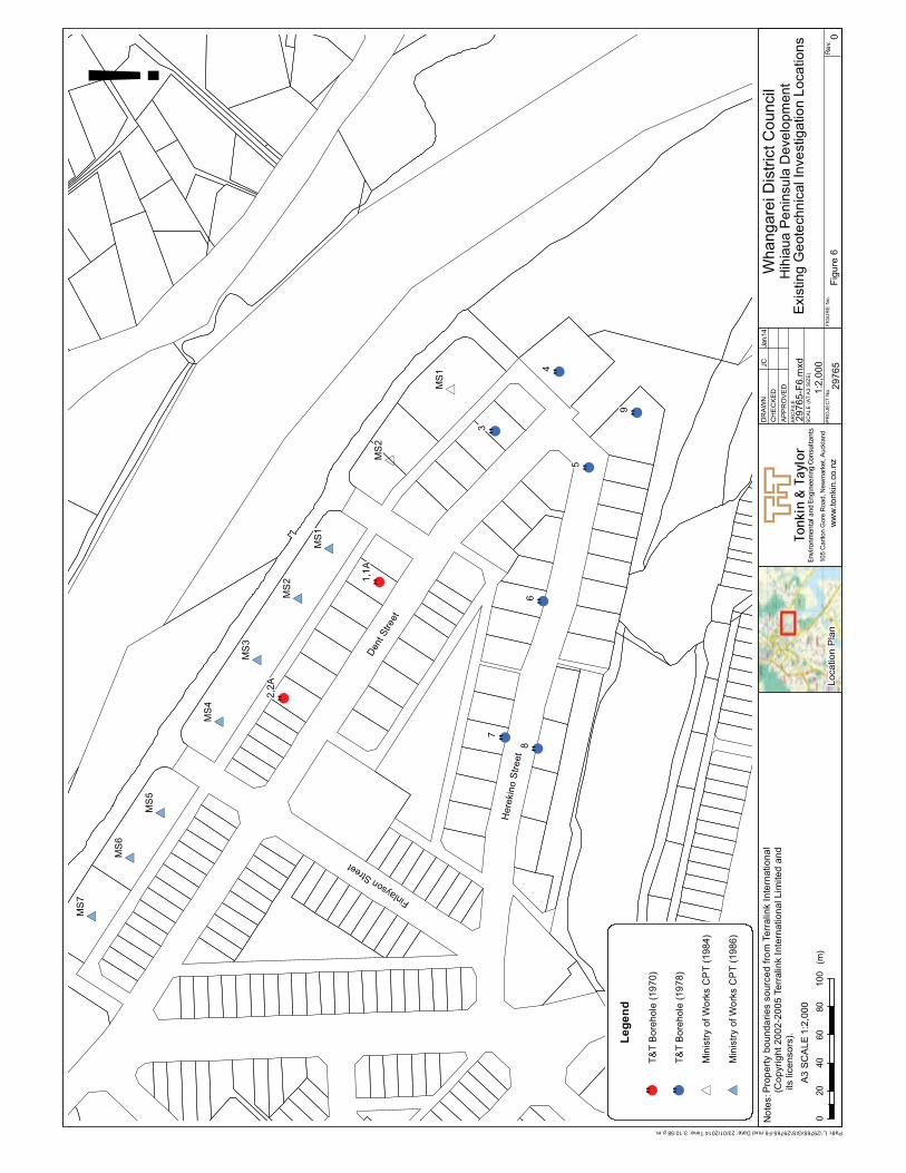
Tonkin
&Taylor
No
tes:
Environm
entalan
dEngine
eringCo
nsultan
tsw
ww
.to
nkin
.co
.nz
SC
AL
E(A
TA
3S
IZE
)
PR
OJE
CT
No
.
AR
CF
ILE
DR
AW
N
CH
EC
KE
D
AP
PR
OV
ED
FIG
UR
EN
o.
Re
v.
# *
# *
# *
# *
# *
# *
# *
*
*!"
!"
!"!"
!"!"
!"!"
!"
Here
kin
oS
treet
DentS
treet
FinlaysonStre
et
MS
1
MS
2
MS
3
MS
4
MS
5
MS
6
MS
7
MS
1
MS
2
1,1
A
2,2
A
3
4
5
6
7
8
9
0
020
40
60
80
10
0(m
)
A3
SC
AL
E
Fig
ure
6
Wh
an
ga
reiD
istr
ictC
ou
ncil
Hih
iaua
Pe
nin
su
laD
eve
lopm
ent
Exis
t ing
Ge
ote
chn
icalIn
ve
stig
atio
nL
oca
tion
s
Lo
ca
tio
nP
lan
1:2
,00
0
29
76
5
105
Carlto
nG
ore
Road,N
ew
mark
et,
Auck
land
1:2
,00
02
97
65
-F6
.mxd
JC
Jan.1
4
Path:L:\29765\GIS\29765-F6.mxdDate:23/01/2014Time:3:10:58p.m.
Pro
pe
rty
bo
un
da
rie
sso
urc
ed
fro
mTe
rra
link
Inte
rna
tio
na
l(C
op
yri
gh
t2
00
2-2
00
5Te
rra
link
Inte
rna
tio
na
lL
imite
da
nd
its
lice
nso
rs).
!L
eg
en
d
!"T
&T
Bo
reh
ole
(19
70
)
!"T
&T
Bo
reh
ole
(19
78
)
*M
inis
try
of
Wo
rks
CP
T(1
98
4)
# *M
inis
try
of
Wo
rks
CP
T(1
98
6)

Geotechnical Assessment, Hihiaua Precinct Plan T&T Ref. 29765
Whangarei District Council February 2014
5 Potential for redevelopment
5.1 General
Being underlain by a thick sequence of soft, saturated and compressible sediments, the
geotechnical conditions of the Hihiaua Peninsula represent significant challenges to further
development. The potential impacts are discussed below.
5.2 Geotechnical limitations
5.2.1 Settlement
Under static conditions, the most significant geotechnical hazard associated with the
peninsula is the settlement of buildings under their own weight. This hazard was mitigated
during the original development of the precinct by preloading the ground with temporary fill.
With a typical preload of 24kPa being applied (T&T, 1981), one or two storey buildings could
be constructed with little to no further significant settlement taking place. This link between
preload and building load has been the guiding principal of the precinct since the 1970’s.
Any shallow-founded building whose weight exceeds the original preload level can be
expected to induce consolidation of the underling soils, and therefore experience settlement.
The greater the weight exceeding the preload, the greater the magnitude of settlement that
will be experienced. We therefore expect that any building that exceeds two storeys in height
will need to be designed so that settlement can be restricted to within tolerable limits
(usually 25mm, although this can be considerably less depending upon the type of building
and any equipment it may contain). It should be noted that settlement could also occur in
one or two storey buildings with unusually high imposed floor loads e.g. warehouse with
pallet stacking.
Settlement is not limited to imposed building loads. Dewatering, either temporarily during
construction or part of permanent drained basement works can result in significant
settlement within the saturated, poorly consolidated soils. The effect of groundwater-
induced settlement can extend for significant distances from the actual dewatering point,
potentially affecting many properties as well as subsurface and surface infrastructure.
5.2.2 Liquefaction and lateral spread
Liquefaction is a process by which a granular material (typically silty sand) suffers a loss of
frictional strength through an increase in the pressure of water between the grains (pore
pressure). This loss in strength can result in significant lateral movement as material slides
under gravity towards lower-lying areas such as harbours and rivers. Liquefaction may result
in a significant loss of foundation bearing capacity, lateral strength and the settlement of
structures.
Typically liquefaction and lateral spreading would not have been considered at the time of
the original peninsula development. Over the past two decades however, both the potential
for, and analysis of liquefaction have become much better understood and now form part of
standard geotechnical assessments.
Existing information for the peninsula indicates the presence of sand, silty sand and sandy
silt layers within the sequence of soft soils that underlie the site. Some of these layers,
particularly the silty sands, may liquefy during severe seismic shaking (say 1 in 500 year
earthquake loading). Experience from past earthquake events, both in New Zealand and
overseas has shown that coastal and harbour-side areas comprising young and/or reclaimed

Geotechnical Assessment, Hihiaua Precinct Plan T&T Ref. 29765
Whangarei District Council February 2014
soils of this type are often be susceptible to liquefaction and lateral spreading or other forms
of ground deformation.
It should be noted that specific liquefaction analyses have not been undertaken as part of
this desktop evaluation. The opinions expressed here are based on our assessment of the
subsurface conditions and experience.
With the peninsula being bound on two sides by streams, there is potential for the entire
peninsula to be affected by lateral spread, rather than just those areas located immediately
adjacent to the water bodies.
Mitigation measures can either be in the form of:
· Soil strengthening (drainage, soil mixing, soil replacement, stone columns);
· Limiting the ability of material to move through the construction of a perimeter in-
ground retaining wall between the peninsula and the streams; or
· The isolation of buildings from the liquefiable zones through piled foundations etc.
With the exception of the in-ground perimeter retaining wall, all of the liquefaction
mitigation options require the removal of existing buildings prior to mitigation works being
undertaken. As liquefaction is typically a risk under longer return period earthquake loads,
accommodating deformations in the structural design can sometimes be a viable option.
Whilst site-specific mitigation works may prevent or limit the extent of liquefaction on a
particular site, the broad scale nature of lateral spreading may mean that seemingly
mitigated areas may still be adversely affected by being enclosed within a broader “raft” of
mobilised material.
5.2.3 Climate change and sea level rise
Low-lying areas such as the Hihiaua Peninsula are at particular risk of being affected by long-
term sea level rise. The effects include not only elevated surface water levels along the
coastal edge of the peninsula but also associated increases in static groundwater levels.
The New Zealand Ministry for the Environment (MfE) has prepared a guidance manual for
evaluating coastal hazards and climate change (MfE, 2008). This guide states that for planning
and decision time frames out to 2090 – 2099, the following should be assumed:
“a) a base value sea-level rise of 0.5 m relative to the 1980–1999 average should be
used, along with;
b) an assessment of the potential consequences from a range of possible higher sea-
level rises (particularly where impacts are likely to have high consequence or where
additional future adaptation options are limited). At the very least, all assessments
should consider the consequences of a mean sea-level rise of at least 0.8 m relative to
the 1980–1999 average. Guidance on potential sea-level rise uncertainties is provided
within the Guidance Manual to aid this assessment.”
Land Information New Zealand (www.linz.govt.nz) gives Mean High Water Springs tide level
at Whangarei as 3.12m above Chart Datum. With the ground level of the peninsula being
approximately 5m above chart datum, this equates to a freeboard of approximately 2m. A
0.5m reduction in the current freeboard could be significant in terms of long-term planning
for this area. In addition, a 0.5m rise in sea level could potentially bring groundwater levels
to within 0.5m to 1.0m of the current ground surface.
An increase in groundwater elevation above current levels can be expected to have a number
of potential effects, including:

Geotechnical Assessment, Hihiaua Precinct Plan T&T Ref. 29765
Whangarei District Council February 2014
· An increased risk of flooding, including water contacting structures;
· An increase in the challenges of constructing basements or other deep excavations;
· Groundwater affecting the construction of shallow foundation systems and in-
ground infrastructure;
· A reduction in the thickness of the non-saturated soil “crust” located above the static
groundwater table which increases susceptibility to liquefaction, and potentially,
lateral spread.
Mitigation of some of these effects may potentially be achieved through an increase of
ground surface or floor elevations, however many others issues, particularly those associated
with excavations and/or retention structures, will require the adoption of appropriate
construction techniques. Depending on what is being constructed, these could have
implications for construction programmes and costs.
5.3 Assessment of Potential Structures
5.3.1 Medium-rise apartments
Given that the historic level of preloading is limited effectively to that of a two storey building,
the construction of apartments up to six stories in height should be expected to result in
settlements well in excess of typically allowable values. A number of options are available to
mitigate the hazards described above.
Deep Piled Foundations
Founding a building on piles allows most of the foundation loads to be transmitted to more
competent materials located at depth, effectively bypassing the soft compressible soils.
Based on current geotechnical information, piles are likely to be in excess of 20m in length in
order to reach a dense sand/gravel layer recorded in BH7. Additional geotechnical
investigations will be required in order to confirm both the lateral extent and thickness of
this potential pile founding layer. A system of deep piles can add significant costs to a building
project.
Piled structures are likely to be more resistant to the effects of liquefaction and lateral
spreading, although some (potentially significant) deformations could still occur depending
on the design adopted, the magnitude of the seismic event and the depth of displacement.
Ground Improvement
A range of ground improvement techniques are available through which the compressibility
and load carrying capacity of the upper soils can be improved. Preloading has already been
undertaken across the site. Further preloading is not considered a viable means of ground
improvement as it could only be undertaken on individual sites as each came up for
development and the settlement induced by preloading can be expected to affect adjacent
buildings.
Possible ground improvement techniques that might be considered include soil mixing and
reinforcement with driven timber poles or stone columns. The selection of one ground
improvement technique over another will depend upon the specifics of the proposed
building. Those methods that result in significant ground vibration e.g. dynamic compaction
are not considered appropriate as they could result in damage to adjacent structures as well
as being a nuisance to occupants of those properties.
Most ground improvement techniques (except preloading and wick drains) also partially or
completely mitigate the effects of liquefaction and possibly lateral spreading, although not
necessarily to the specifics of the design seismic event.

Geotechnical Assessment, Hihiaua Precinct Plan T&T Ref. 29765
Whangarei District Council February 2014
Compensated Foundations
By including a basement level(s) within a structure’s design, the weight of the building can
be balanced against the weight of the soil removed and any hydrostatic uplift forces i.e. a
compensated foundation. By balancing the forces so that there is no overall increase in
imposed loads, settlement can be minimised or eliminated. Compensated foundations can
be an attractive alternative to piled foundations provided that constructability issues can be
addressed and that groundwater levels (buoyance forces) remain relatively static.
Compensated buildings will have to address liquefaction and lateral spreading risks which are
unlikely to be mitigated simply by adopting a basement foundation.
Combination Solutions
Depending upon the development being considered, settlement may be mitigated through a
combination of two or more options e.g. a partially compensated foundation with a piled
slab.
5.3.2 Low-rise apartments and terrace housing
Low-rise apartments (up to three storeys) and terrace housing will likely impose foundation
loads in excess of the existing preload. Any of the foundation options discussed above could
conceivably be used to mitigate the settlement hazard associated with low-rise structures,
although compensated foundations or some additional preloading may be more
economically viable that would deep piled foundations. As with all potential development
options, some form of mitigation or accommodation for liquefaction and lateral spreading is
likely to be required.
5.3.3 Basement and semi-basement car parking
The potential for constructing basement or semi-basement car parking facilities for some
buildings is dependant upon the constructability of stable, water-tight walls within the soft
dredge tailings and natural sediments that underly the fill. The primary issue is the retention
of these soft collapsable materials during construction using either temporary or permanent
retaining walls. Retention options include sheet pile walls, secent pile walls, and diaphram
walls. The method adopted will depends upon the type and scale the structure to be built,
the depth of excavation, the proximity or otherwise of sensitive neighbouring strucures, cost
and familiarity of the constructor with these techniques.
A significant potential issue is possible damage to adjacent structures from:
· displacement of the basement wall towards the excavation;
· dewatering-induced ground settlement; and
· vibrations associated with the installation of sheet piles.
Both settlement and property damage issues can be managed through appropriate
methodologies and monitoring. The mitigation measures for basement construction are
likely to be beneficial in reducing the effects of liquefaciton and lateral spreading, although
they may not fully mitigate these hazards.
5.3.4 Work/Live units
The viability of work/live units will depend upon the height of the buildings. The discussions
presented above apply to this option.

Geotechnical Assessment, Hihiaua Precinct Plan T&T Ref. 29765
Whangarei District Council February 2014
6 Discussion and Conclusions
The Hihiaua Peninsula is a light industrial/commercial district of Whangarei located in an area
which was a low-lying to intertidal zone at the confluence of the Waiarohia Stream and Hatea
River. Preloading of the current precinct has allowed the successful development of
numerous one and two storey buildings since the 1970’s, although the subsurface conditions
have not been tested under seismic loading conditions.
Redevelopment of the area may require the construction of buildings that are significantly
larger than those built to date. Those buildings that exceed the current height limit of 2
storeys can be expected to induce settlements within the soft compressible soils that
underlie the site. A range of options exist for mitigating the settlement hazard, including piled
foundations, compensated foundations or ground improvement. Each of these can be
assessed on their merit for each project as well as the potential impact on adjacent
properties.
The construction of basements or semi-basements in the soft sediments that underlie the
surficial fill will be challenging, although still suitable for standard construction techniques. A
higher than usual level of geotechnical design, construction supervision and mitigation
planning should however be expected. The high groundwater conditions of the peninsula is
potentially a significant issue, particularly with respect to basement construction. Under
static conditions, settlement and groundwater inflow effects can typically be mitigated with
conventional solutions, although this is likely to require additional design.
Under seismic conditions, there is potential for liquefaction and lateral spreading to occur,
and this is likely to impose deformations and possibly tilting on structures at the peninsula.
The liquefaction hazard and its mitigation will require site specific assessment and design.
Depending on the assessed intensity of seismic effects, mitigation of liquefaction and lateral
spreading may potentially be expensive or problematic.
Any future increase in sea level will result in a corresponding increase in groundwater levels
across the peninsula. Such an increase in water levels could, depending on the magnitude
and timeframes being considered, increase the potential for inundation or flooding across
the peninsula. Future developments may need to consider increases in ground level (by
filling) or an increase in ground floor elevations. Increased groundwater levels also have
direct implications for the challenges associated with the construction of excavations,
foundations and infrastructure. An increase in groundwater elevation also increases the
susceptibility to liquefaction and lateral spreading by reducing the thickness of the dry non-
liquefiable “crust” directly underlying the ground surface.
In summary, the proposed redevelopment of the Hihiaua Peninsula has geotechnical
challenges under both static and seismic conditions. These can be mitigated, however this
will often require specific investigation and assessment and can be expected to have higher
costs compared to equivalent developments located elsewhere.

Geotechnical Assessment, Hihiaua Precinct Plan T&T Ref. 29765
Whangarei District Council February 2014
7 References
Ministry of the Environment, 2008. Coastal Hazards and Climate Change: A guidance
manual for local government in New Zealand.
Richardson Stevens, 2001. Engineering Report, New Building for F Gibson, Lower Dent
Street, Whangarei.
Tonkin & Taylor, 1970. Hihiaua Subdivision Investigation Settlements. Report to Northland
Harbour Board dated 12 February 1970. T&T Ref 1809.
Tonkin & Taylor, 1978. Hihiaua Subdivision – Soil Investigation for Remaining Stages. Report
to Northland Harbour Board dated November 1978. T&T Ref 4163.
Tonkin & Taylor, 1981. Hihiaua Subdivision: Block 3 (Stage 1). Letter to Northland Harbour
Board dated15 June 1981.
Tonkin & Taylor, 1984a. Hihiaua Industrial Subdivision, Suitability of Lots 137-162. Letter
report to Northland Harbour Board dated 1 June 1984. T&T Ref 4163.

Geotechnical Assessment, Hihiaua Precinct Plan T&T Ref. 29765
Whangarei District Council February 2014
8 Applicability
This report has been prepared for the benefit of Whangarei District Council with respect to
the particular brief given to us and it may not be relied upon in other contexts or for any
other purpose without our prior review and agreement.
Tonkin & Taylor Ltd
Environmental and Engineering Consultants
Report prepared by: Authorised for Tonkin & Taylor Ltd by:
.......................................................... PP........................….......…...............
Kevin J. Hind Andrew Langbein
Engineering Geologist Project Director
kjh
kjh.hihiaua_final_report.docx
93
Appendix 2: HAIL Classification From Quotable Value: Category and Land Use Codes

Category CMC - Commercial - Motor Vehicles - Central
CMP - Commercial - Motor Vehicles - Provincial CMS - Commercial - Motor Vehicles - Suburban CSC - Commercial - Service stations - Central CSS - Commercial - Service stations - Suburban HBC - Horticulture - Berry fruit - Below average economic HCC - Horticulture - Citrus - Below average economic HCE - Horticulture - Citrus - Uneconomic with dwelling HCF - Horticulture - Citrus - Uneconomic without dwelling HF* - Horticulture - Flowers HE* - HE HK* - Horticulture - Kiwifruit HM* - Horticulture - Market garden HP* - Horticulture - Pip fruit HS* - Horticulture - Stone fruit HVB - Horticulture - Vineyards - Average - good econmoic HVF - Horticulture - Vineyards - Uneconomic without dwelling HX* - Horticulture - Mixed/other INC - Industrial - Noxious or dangerous - Central INP - Industrial - Noxious or dangerous - Provincial INS - Industrial - Noxious or dangerous - Suburban MC - Mining - Coal fields MR - Mining - Rock/shingle/sand MX - Mining - Mixed/unknown OM - Other - Maori sites (urupa, marae) OS - Other - Sports UC - Utilities UE - Utilities - Energy UG - Utilities - Generating UR - Utilities - Railway networks UT - Utilities - Telecommunications
Land Use 15 Market Gardens and Orchards
18 Mineral Extraction 35 Air transport 42 Medical and Allied 45 Defence 47 Cemeteries and Crematoria 61 Communications 62 Electricity 63 Gas 65 Sanitary 72 Textiles, Leather and Fur 73 Timber Products and Furniture 75 Engineering, Metalworking, Appliances and Machinery 76 Chemicals, Plastics, Rubber and Paper 78 Depots and Yards
Source: TRIM 13/9928 HAIL (Hazardous Activities and Industries List) Data and the codes from
Quotable Value : Land Use and Category from Tech1 that trigger a HAIL on a property
94
Appendix 3: Whangarei District Council HAIL Sites Located in the Hīhīaua Precinct
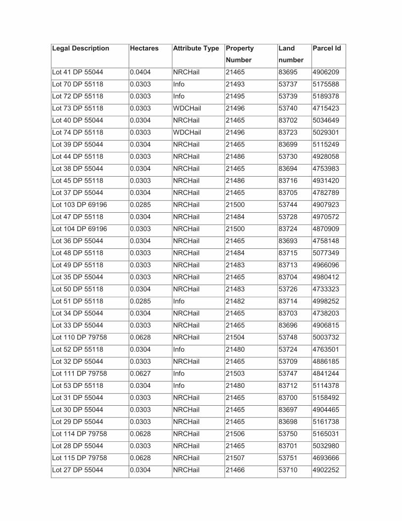
Legal Description Hectares Attribute Type Property
Number
Land
number
Parcel Id
Lot 41 DP 55044 0.0404 NRCHail 21465 83695 4906209
Lot 70 DP 55118 0.0303 Info 21493 53737 5175588
Lot 72 DP 55118 0.0303 Info 21495 53739 5189378
Lot 73 DP 55118 0.0303 WDCHail 21496 53740 4715423
Lot 40 DP 55044 0.0304 NRCHail 21465 83702 5034649
Lot 74 DP 55118 0.0303 WDCHail 21496 83723 5029301
Lot 39 DP 55044 0.0304 NRCHail 21465 83699 5115249
Lot 44 DP 55118 0.0303 NRCHail 21486 53730 4928058
Lot 38 DP 55044 0.0304 NRCHail 21465 83694 4753983
Lot 45 DP 55118 0.0303 NRCHail 21486 83716 4931420
Lot 37 DP 55044 0.0304 NRCHail 21465 83705 4782789
Lot 103 DP 69196 0.0285 NRCHail 21500 53744 4907923
Lot 47 DP 55118 0.0304 NRCHail 21484 53728 4970572
Lot 104 DP 69196 0.0303 NRCHail 21500 83724 4870909
Lot 36 DP 55044 0.0304 NRCHail 21465 83693 4758148
Lot 48 DP 55118 0.0303 NRCHail 21484 83715 5077349
Lot 49 DP 55118 0.0303 NRCHail 21483 83713 4966096
Lot 35 DP 55044 0.0303 NRCHail 21465 83704 4980412
Lot 50 DP 55118 0.0304 NRCHail 21483 53726 4733323
Lot 51 DP 55118 0.0285 Info 21482 83714 4998252
Lot 34 DP 55044 0.0304 NRCHail 21465 83703 4738203
Lot 33 DP 55044 0.0303 NRCHail 21465 83696 4906815
Lot 110 DP 79758 0.0628 NRCHail 21504 53748 5003732
Lot 52 DP 55118 0.0304 Info 21480 53724 4763501
Lot 32 DP 55044 0.0303 NRCHail 21465 53709 4886185
Lot 111 DP 79758 0.0627 Info 21503 53747 4841244
Lot 53 DP 55118 0.0304 Info 21480 83712 5114378
Lot 31 DP 55044 0.0303 NRCHail 21465 83700 5158492
Lot 30 DP 55044 0.0303 NRCHail 21465 83697 4904465
Lot 29 DP 55044 0.0303 NRCHail 21465 83698 5161738
Lot 114 DP 79758 0.0628 NRCHail 21506 53750 5165031
Lot 28 DP 55044 0.0303 NRCHail 21465 83701 5032980
Lot 115 DP 79758 0.0628 NRCHail 21507 53751 4693666
Lot 27 DP 55044 0.0304 NRCHail 21466 53710 4902252

Lot 84 DP 55118 0.0304 Info 21541 53785 4865968
Lot 126 DP 79758 0.06 NRCHail 21532 53776 5156653
Lot 26 DP 55044 0.0304 NRCHail 21466 83706 5024125
Lot 85 DP 55118 0.0304 NRCHail 21542 53786 5164316
Lot 60 DP 55118 0.0259 Info 21475 53719 4792136
Lot 25 DP 55044 0.0304 Info 21471 83707 5039285
Lot 117 DP 93291 0.0797 NRCHail 21509 53753 5135378
Lot 24 DP 55044 0.0304 Info 21471 53715 4764462
Lot 88 DP 55118 0.0304 NRCHail 21545 53789 4886179
Lot 129 DP 79758 0.03 Info 21527 53771 4924747
Lot 118 DP 93291 0.0628 NRCHail 21510 53754 4764846
Lot 23 DP 55044 0.0304 WDCHail 21472 83708 5178210
Lot 22 DP 55044 0.0304 WDCHail 21472 53716 4781073
Lot 21 DP 55044 0.0304 NRCHail 21473 83709 4895783
Lot 91 DP 55118 0.0304 Info 21547 83745 4741496
Lot 140 DP 102847 0.0593 NRCHail 21864 54108 5151536
Lot 92 DP 55118 0.0224 Info 21547 53791 4756384
Lot 20 DP 55044 0.0297 NRCHail 21473 53717 4829363
Lot 133 DP 93291 0.0715 NRCHail 21522 53766 4954576
Lot 141 DP 102847 0.0593 NRCHail 21865 54109 5019306
Lot 142 DP 102847 0.0593 Info 32143 64387 4973565
Lot 145 DP 102848 0.0673 Info 21868 54112 5116360
Lot 1 DP 72013 0.2545 Info 21552 83747 4810189
Lot 149 DP 102847 0.0549 Info 30171 54133 4841973
Lot 150 DP 102847 0.0653 Info 21888 54132 5189060
Lot 136 DP 93291 0.0997 WDCHail 21520 53764 5007212
Pt Lot 23 DP 43791 0.0461 Info 21552 53795 4850184
Lot 156 DP 102848 0.065 WDCHail 21875 83861 5108469
Lot 157 DP 102848 0.0585 WDCHail 21875 54119 4890932
Lot 158 DP 102848 0.0585 NRCHail 21873 83860 4776910
Lot 162 DP 102848 0.1751 Info 21871 54115 4763357
Lot 159 DP 102848 0.0585 NRCHail 21873 54117 5096932
Lot 160 DP 102848 0.0585 NRCHail 21873 83859 4887623
Lot 161 DP 102848 0.0585 WDCHail 21872 54116 4975643