high resolution land use information by combined analysis
TRANSCRIPT
High Resolution Land Use Information by combined Analysis of Digital Landscape Models and Statistical Data Sets
Tobias Krüger
Gotthard Meinel
Tobias Krüger, Gotthard Meinel
Using Digital Landscape Models for Land Use Statistics
Agenda
Monitoring approach
Input Data
Data Processing
Output Data and Presentation
Conclusion
Tobias Krüger, Gotthard Meinel
Using Digital Landscape Models for Land Use Statistics
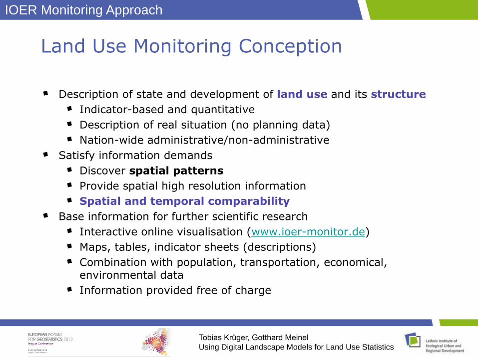
Land Use Monitoring Conception
Description of state and development of land use and its structure
Indicator-based and quantitative
Description of real situation (no planning data)
Nation-wide administrative/non-administrative
Satisfy information demands
Discover spatial patterns
Provide spatial high resolution information
Spatial and temporal comparability
Base information for further scientific research
Interactive online visualisation (www.ioer-monitor.de)
Maps, tables, indicator sheets (descriptions)
Combination with population, transportation, economical, environmental data
Information provided free of charge
IOER Monitoring Approach
Tobias Krüger, Gotthard Meinel
Using Digital Landscape Models for Land Use Statistics
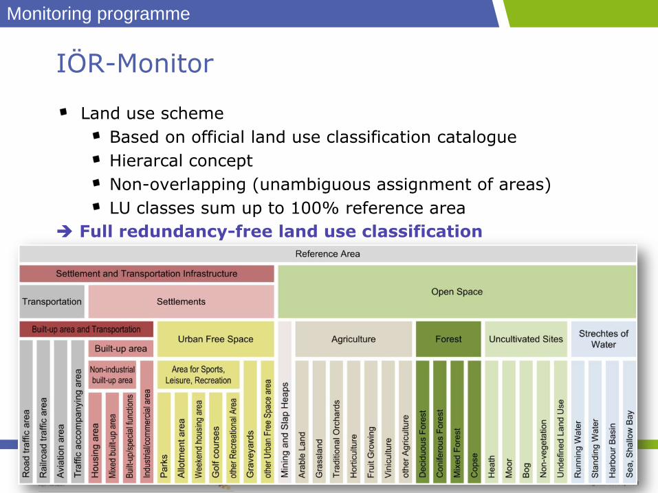
IÖR-Monitor
Land use scheme
Based on official land use classification catalogue
Hierarcal concept
Non-overlapping (unambiguous assignment of areas)
LU classes sum up to 100% reference area
Full redundancy-free land use classification
Monitoring programme
Tobias Krüger, Gotthard Meinel
Using Digital Landscape Models for Land Use Statistics
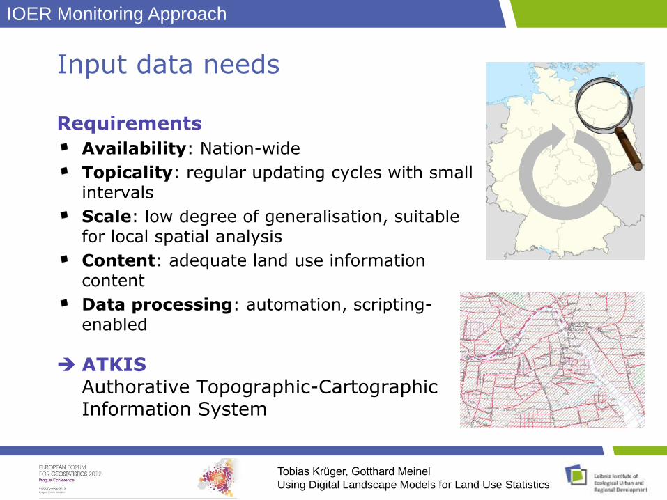
Input data needs
Requirements
Availability: Nation-wide
Topicality: regular updating cycles with small intervals
Scale: low degree of generalisation, suitable for local spatial analysis
Content: adequate land use information content
Data processing: automation, scripting-enabled
ATKISAuthorative Topographic-Cartographic Information System
IOER Monitoring Approach
Tobias Krüger, Gotthard Meinel
Using Digital Landscape Models for Land Use Statistics
ATKIS(R) Authorative Topographic-Cartographic Information System
Authorative defined by the Working Committee of the
Surveying Authorities of the States of the Federal Republic of Germany
Topographic comprehensive description of the earth surface
(DLM, DTM, DOP)
Cartographic Basis for official topographic map series
1:10’000 – 1:1’000’000
Information System object based spatial information
system
Digital Basis Landscape Model (Basic DLM)Digital Terrain Model (DTM)
Digital Surface Model (DSM)
Digital Orthophotos (DOP)
Digital Topographical Maps (DTK)
IOER Monitoring Approach
Tobias Krüger, Gotthard Meinel
Using Digital Landscape Models for Land Use Statistics
Basic DLM
Object type catalogue
>100 object types
Geometrical domain: Polygons, Polylines, Points
Semantical description:>60 Attributes
Extensive semantic differentiation of objects
Target mapping scale: 1:10000/1:25000
Most precise geo-topographical dataset in with nation wide availability in Germany
Authoritative dataset
Regular updating (3 years)
Basis for topographic map series
IOER Monitoring Approach
Tobias Krüger, Gotthard Meinel
Using Digital Landscape Models for Land Use Statistics
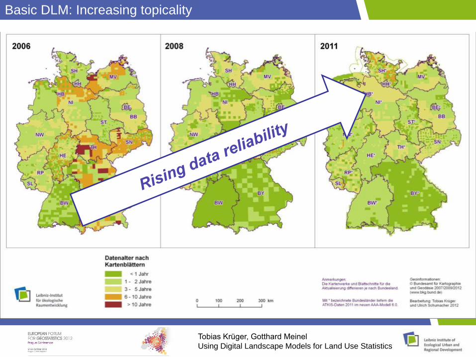
Basic DLM: Increasing topicality
Tobias Krüger, Gotthard Meinel
Using Digital Landscape Models for Land Use Statistics
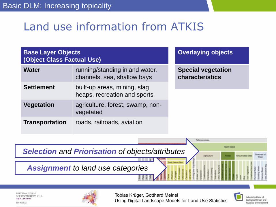
Land use information from ATKIS
Base Layer Objects
(Object Class Factual Use)
Water running/standing inland water,
channels, sea, shallow bays
Settlement built-up areas, mining, slag
heaps, recreation and sports
Vegetation agriculture, forest, swamp, non-
vegetated
Transportation roads, railroads, aviation
Overlaying objects
Special vegetation
characteristics
Assignment to land use categories
Selection and Priorisation of objects/attributes
Basic DLM: Increasing topicality
Tobias Krüger, Gotthard Meinel
Using Digital Landscape Models for Land Use Statistics
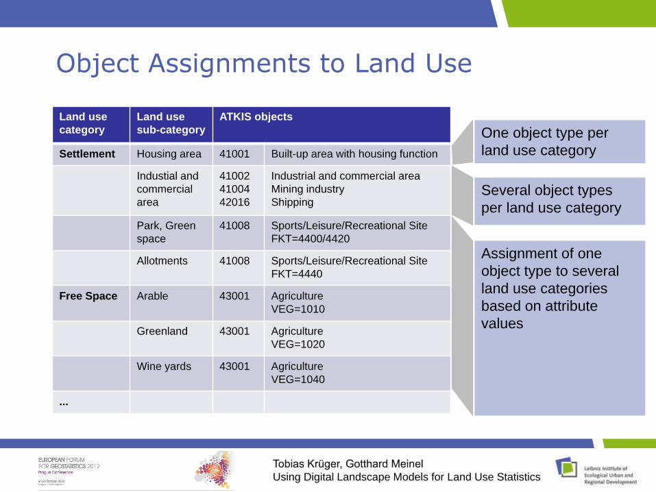
Object Assignments to Land Use
Land use
category
Land use
sub-category
ATKIS objects
Settlement Housing area 41001 Built-up area with housing function
Industial and
commercial
area
41002
41004
42016
Industrial and commercial area
Mining industry
Shipping
Park, Green
space
41008 Sports/Leisure/Recreational Site
FKT=4400/4420
Allotments 41008 Sports/Leisure/Recreational Site
FKT=4440
Free Space Arable 43001 Agriculture
VEG=1010
Greenland 43001 Agriculture
VEG=1020
Wine yards 43001 Agriculture
VEG=1040
...
Several object types
per land use category
Assignment of one
object type to several
land use categories
based on attribute
values
One object type per
land use category
Tobias Krüger, Gotthard Meinel
Using Digital Landscape Models for Land Use Statistics
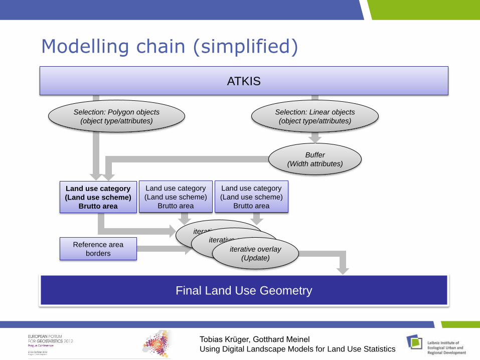
Modelling chain (simplified)
Selection: Polygon objects
(object type/attributes)
Buffer
(Width attributes)
Selection: Linear objects
(object type/attributes)
Land use category
(Land use scheme)
Brutto area
Reference area
borders
iterative overlay
(Update)
Final Land Use Geometry
iterative overlay
(Update)
ATKIS
Land use category
(Land use scheme)
Brutto area
iterative overlay
(Update)
Land use category
(Land use scheme)
Brutto area
Tobias Krüger, Gotthard Meinel
Using Digital Landscape Models for Land Use Statistics
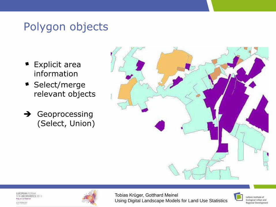
Polygon objects
Explicit area information
Select/mergerelevant objects
Geoprocessing
(Select, Union)
Tobias Krüger, Gotthard Meinel
Using Digital Landscape Models for Land Use Statistics
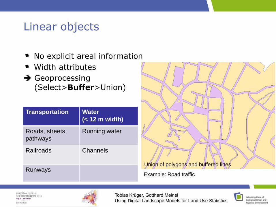
Linear objects
No explicit areal information
Width attributes
Geoprocessing
(Select>Buffer>Union)
Transportation Water
(< 12 m width)
Roads, streets,
pathways
Running water
Railroads Channels
RunwaysRoad traffic polygon objectsLinear objects: Roads and driving lanesBuffering of linear objects
Example: Road traffic
Union of polygons and buffered lines
Tobias Krüger, Gotthard Meinel
Using Digital Landscape Models for Land Use Statistics
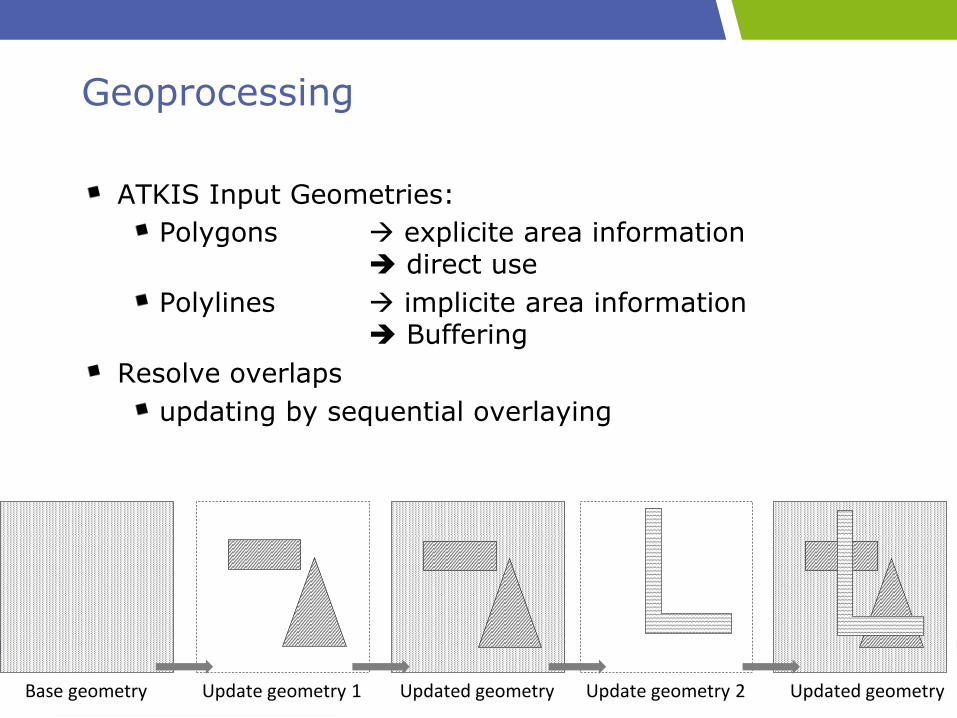
Geoprocessing
ATKIS Input Geometries:
Polygons explicite area information direct use
Polylines implicite area information Buffering
Resolve overlaps
updating by sequential overlaying
Base geometry Update geometry 1 Updated geometry Update geometry 2 Updated geometry
4. Dresdner Flächennutzungssymposium, 14.-15. Juni 2012
G. Meinel, T. Krüger, U. Schumacher, J. Hennersdorf, J. Förster
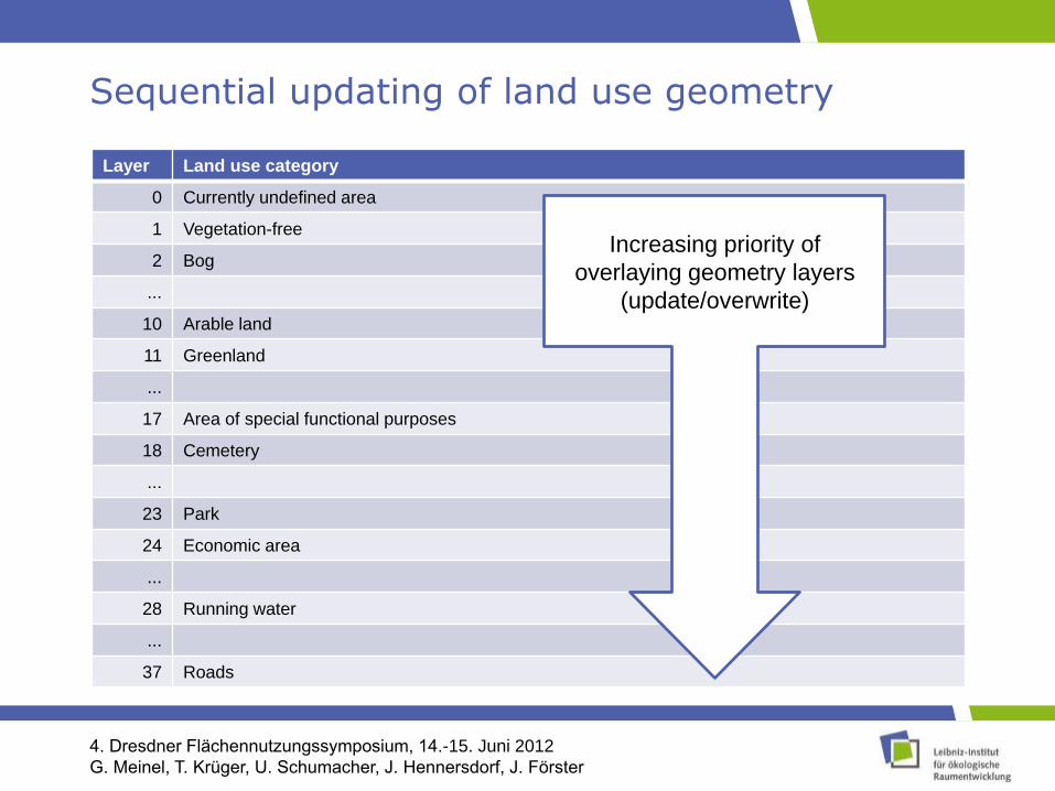
Sequential updating of land use geometry
Layer Land use category
0 Currently undefined area
1 Vegetation-free
2 Bog
...
10 Arable land
11 Greenland
...
17 Area of special functional purposes
18 Cemetery
...
23 Park
24 Economic area
...
28 Running water
...
37 Roads
Increasing priority of
overlaying geometry layers
(update/overwrite)
Tobias Krüger, Gotthard Meinel
Using Digital Landscape Models for Land Use Statistics
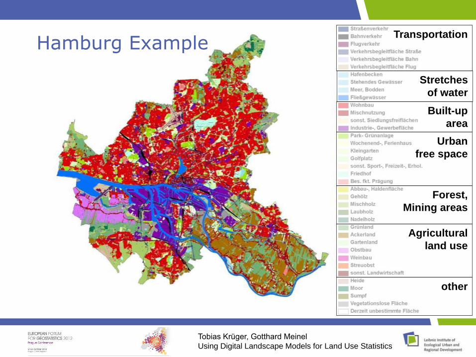
Hamburg ExampleTransportation
Stretches
of water
Built-up
area
Urban
free space
Forest,
Mining areas
Agricultural
land use
other
Tobias Krüger, Gotthard Meinel
Using Digital Landscape Models for Land Use Statistics
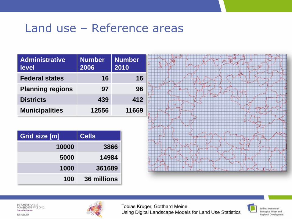
Land use – Reference areas
Administrative
level
Number
2006
Number
2010
Federal states 16 16
Planning regions 97 96
Districts 439 412
Municipalities 12556 11669
Grid size [m] Cells
10000 3866
5000 14984
1000 361689
100 36 millions
Tobias Krüger, Gotthard Meinel
Using Digital Landscape Models for Land Use Statistics
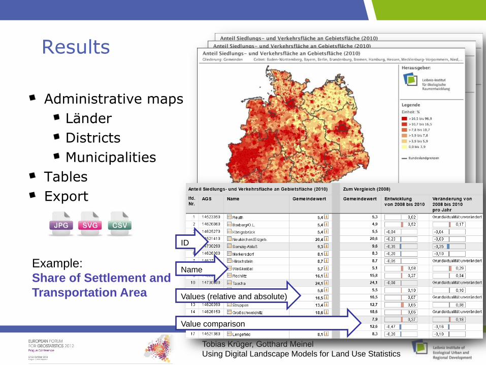
Results
Administrative maps
Länder
Districts
Municipalities
Tables
Export
Example:
Share of Settlement and
Transportation Area
ID
Name
Values (relative and absolute)
Value comparison
Tobias Krüger, Gotthard Meinel
Using Digital Landscape Models for Land Use Statistics
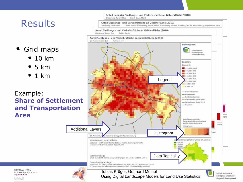
Results
Grid maps
10 km
5 km
1 km
Example:Share of Settlement and Transportation Area
Additional Layers
Data Topicality
Histogram
Legend
Tobias Krüger, Gotthard Meinel
Using Digital Landscape Models for Land Use Statistics
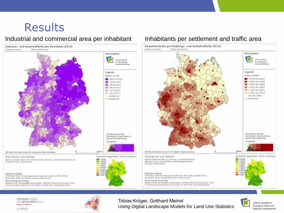
ResultsIndustrial and commercial area per inhabitant Inhabitants per settlement and traffic area
Tobias Krüger, Gotthard Meinel
Using Digital Landscape Models for Land Use Statistics
Conclusion
ATKIS data (Topographical base data)
Nation-wide availability Homogeneous data for all federal states
Semantically differentiated rich area-covering information
Target scale ~ 1:10.000, i.e. few generalisation geometrical correctness
Object based digital data model High degree of automation possible
Problems
Slightly different modelling practice in federal states in some cases limited spatial comparability
currently change in ATKIS model definition limited temporal comparability
Updating cycles up to federal states Varying regional/local topicality Object changes due to in-situ-changes or data corrections?
Large dataset (Base DLM: ~ 20 GB) Scripting limitations/sequential data processing
Tobias Krüger, Gotthard Meinel
Using Digital Landscape Models for Land Use Statistics
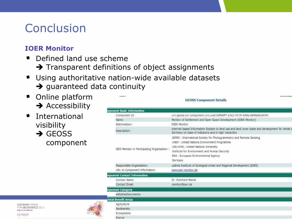
Conclusion
IOER Monitor
Defined land use scheme Transparent definitions of object assignments
Using authoritative nation-wide available datasets guaranteed data continuity
Online platform Accessibility
International visibility GEOSS
component
Tobias Krüger, Gotthard Meinel
Using Digital Landscape Models for Land Use Statistics
Outlook
Densification of time series ( annual)
Further indicators
Protected areas (already in use)
Landscape fragmentation (in progress)
Ecological landscape quality (hemeroby indicators; defined but not yet implemented)
Building based indicators (in progress)
Better visualisation
Exhanced data viewer
Web Mapping Services
Tobias Krüger, Gotthard Meinel
Using Digital Landscape Models for Land Use Statistics
ContactTobias Krüger
Weberplatz 101217 DresdenE-Mail: [email protected]