resolution no. whereas, the environment and land use ... · resolution no. 2748 a resolution...
TRANSCRIPT

RESOLUTION NO. 2748
A RESOLUTION ACCEPTING THE CHAMPAIGN COUNTY
LAND EVALUATION AND SITE ASSESSMENT SYSTEM
WHEREAS, t h e Environment and Land Use Committee has c a r e f u l l y
s t u d i e d t h e proposed Champaign County Land Eva lua t i on and S i t e
Assessment System and recommends t h e County Board accept t h e system
as a t o o l t o a s s i s t i n making 1 and use dec is ions ; and,
WHEREAS, t h e Champaign County Board has c a r e f u l l y cons idered
t h e Land Eva lua t i on and S i t e Assessment System and f i n d s t h a t t h i s
System cou ld p rov ide va luab le guidance and ass is tance t o t h e County
Board, t h e Environment and Land Use Committee, and t h e Zoning Board
o f Appeals i n making l and use dec i s i ons a f f e c t i n g t h e f u t u r e
development o f t h e County 's a g r i c u l t u r a l land; and
WHEREAS, t h e Champaign County Board f u r t h e r f i n d s t h e Land
Eva lua t i on and S i t e Assessment System an app rop r i a te t o o l t o be
used i n c o n j u n c t i o n w i t h t h e County 's Land Use Goals and P o l i c i e s ,
as a bas i s f o r t h e con t inued implementat ion o f t h e County Zoning
Ordinance and Ordinance Regu la t ing Development i n Specia l F lood
Hazard Areas, and f o r t h e o v e r a l l p r o t e c t i o n o f t h e p u b l i c hea l t h ,
sa fe ty and we l fa re of t h e r e s i d e n t s of Champaign County;
WHEREAS, t h e County Board, Environment and Land Use Committee
and Zoning Board of Appeals s h a l l use t h e Champaign County Land
Eva lua t i on and S i t e Assessment System as a t o o l f o r making l and use
dec i s i ons a f f e c t i n g a g r i c u l t u r a l land;
NObf, THEREFORE, BE I T RESOLVED, t h a t t h e document e n t i t l e d
Champaign County Land Eva lua t i on and S i t e Assessment System, dated
February , 1984, i s hereby adopted as a t o o l f o r making l and use dec i s i ons .
PRESENTED, ADOPTED, APPROVED AND RECORDED t h i s 21s t day o f

Champaign County, Illinois
D EVALUATION
AND
SITE ASSESSMENT
SYSTEM
The f o l l o w i n g two Committees prepared t h i s Land Eva lua t i on and S i t e Assessment System f o r Champaign County, I l l i n o i s .
Land Evaluat ion Committee
Joe Barkley, Resource Conserva t ion is t , Champaign County S o i l and Water Conservation D i s t r i c t
Tyrone Clapper, Champaign County Zoning Admin i s t ra to r Ken Kesler, Chairman, Board o f D i rec to rs , Champaign County S o i l and Water Conservation
Di s t r i c t Ron Lowery, D i s t r i c t Conserva t ion is t , S o i l Conservat ion Service, Un i ted States Department'
o f A g r i c u l t u r e B i l l McNamara, Senior Extension Adviser, A g r i c u l t u r e Cooperat ive Extension Service,
U n i v e r s i t y o f I l l i n o i s L o i s Rocker, Associate Planner, Champaign County Regional Planning Commi ss ion Bob Wendt, Manager, Champaign County Farm Bureau
S i t e Assessment Committee
Joe Barkley, Resource Conversa t ion is t , Charnpaigfi County S o i l and Water Conservation D i s t r i c t
Tyrone Clapper, Champaign County Zoning Admin i s t ra to r Gerald Conpton, Land.Use Committee Co-Chairman, Champaign County Farm Bureau Don Flessner, Member, Champaign County Board Ken Kesler, Chairman, Board o f D i rec to rs , Champaign County S o i l and Water Conservation
D i s t r i c t Any Kunmerow, Member, Champaign County Board
. 'Ron Lowery, D i s t r i c t Conserva t ion is t , S o i l Conservat ion Service, Uni ted States Department o f Ag r i cu l t u re
L o i s Rocker, Associate Planner, Champaign County Regional Planning Commission Susan Stone, Land Use Chairman, League o f Women Voters Laurel Talkington, Planner 11, Planning and Economic Development Department, City o f
Champai gn Russel l Taylor, Member, Champaign County Board Clarence Thompson, President , Northwood, Inc.
S ta te Resource Consul tants
Ronald A. Darden, Superintendent, D i v i s i o n o f Na tu ra l Resources, I l l i n o i s Department o f A g r i c u l t u r e
Carolyn b1. Sands, Former S t a f f Member, Bureau o f Farmland P ro tec t i on , D i v i s i o n o f Natura l Resources, I l l i n o i s Department o f A g r i c u l t u r e
Typing, P r i n t i n g and Graphics
V i c k i Shingleton, A d m i n i s t r a t i v e Secretary, Champaign County Regional Planning Commission Tom Reed, Graphics Technician, Champaign County Regional Planning Commission

CHAMPAIGN COUNTY LAND EVALUATION AND SITE ASSESSMENT SYSTEM
TABLE OF CONTENTS
Page

I. In t roduc t ion
The Champaign County Land Eva luat ion and S i t e Assessment system (LESA), i s a program designed t o evaluate t h e v i d b i l i T y o f a s i t e f o r a g r i c u l t u r a l uses. Although the system i t s e l f was developed by t h e S o i l Conservat ion Serv ice o f t h e U.S. Department o f Ag r i - cu l tu re , the County 's LESA system was prepared l o c a l l y t o take i n t o cons idera t ion l o c a l condi t ions such as phys ica l c h a r a c t e r i s t i c s o f t h e land, c o m p a t i b i l i t y o f surrounding land uses, and urban g r o w t h . f a c t o r s a f f e c t i n g land development.
A's zits name impl ies , LESA i s d i v i d e d i n t o two pa r t s . F i r s t , i n the Land Evalu- a t i o n po r t i on o f t h e system, s o i l s o f a g iven area are r a t e d and placed i n t o groups ranging from t h e b e s t t o worst based on s o i l c h a r a c t e r i s t i c s , c a p a b i l i t i e s , and produc- t i v i t y . The second p a r t o f t he system, S i t e Assessment, i d e n t i f i e s important fac tors other than s o i l s t h a t c o n t r i b u t e t o t h e q u a l i t y o f a s i t e f o r a g r i c u l t u r a l uses. App l i - c a t i o n o f LESA combines a value f o r Land Eva luat ion w i t h a value f o r S i t e Assessment t o determine the t o t a l value o f a g iven s i t e f o r a g r i c u l t u r a l uses. The Land Evaluat ion i s assigned a maximum o f 100 po in ts , and t h e S i t e Assessment i s assigned a maximum o f 200 po in ts . The t o t a l maximum number o f p o i n t s poss ib le f o r any s i t e i s 300. The h igher t h e t o t a l value o f a s i t e , t h e h igher t h e a g r i c u l t u r a l economic v i a b i l i t y , and the h igher t h e cos t f o r non -ag r i cu l tu ra l development.
The Champaign County LESA System w i l l p rov ide a va luab le new t o o l t o guide i n making land use dec is ions i n Champaign County. App l i ca t i ons o f t h e LESA system w i l l gen- . e r a l l y f a l l under two types o f requests i n v o l v i n g convers ion o f an a g r i c u l t u r a l use t o a non-agr icu l tu ra l use. The most f requent a p p l i c a t i o n o f LESA w i l l be when a request i s made t o rezone a t r a c t of land from t h e County'S AG-1, Agr i cu l tu re , AG-2, Agr icu l tu re , and/or C R Y ConservatSon-Recreation D i s t r i c t s t o another zoning d i s t r i c t o r d i s t r i c t s . The LESA system can a l s o be used f o r s i t e comparison t o minimize l o s s o f p roduct ive land when i t i s essent ia l t o conver t some a g r i c u l t u r a l land t o a non-ag r i cu l tu ra l use.
I n using LESA t o he lp determine t h e a d v i s a b i l i t y o f a requested zoning change, reference should always be made t o t h e Champaign County Zoning Ordinance fo r t h e range o f permi t ted uses under t h e requested zoning designat ion. Although a request may be f o r a s p e c i f i c use, once t h e zoning i s changed and t h e proposed use i s no t implemented, a number o f o ther uses cou ld be pe rm i t ted w i thout r e q u i r i n g f u r t h e r approval.
r)
I n apply ing LESA i n Champaign County, t h e user o f t h e system must remember t h a t i t i s one among several t o o l s t o a s s i s t i n making land use decis ions; i t should no t be used alone. This d o c u m e n t ~ c h describes t h e County's LESA system, should be used i n con- j unc t i on w i t h t h e County 's Land Use Goals and P o l i c i e s , as a bas i s f o r t he cont inued implementation o f t h e County's Zoning Ordinance and t h e Ordinance Regulat ing Development o f Special Flood Hazard Areas, and f o r t h e o v e r a l l p r o t e c t i o n o f t h e p u b l i c heal th, s a f e t y and we l fa re o f t h e r e s i d e n t s o f Champaign County. Since t h e County's LESA System i s designed t o be based on e x i s t i n g cond i t ions , t h i s system r e q u i r e s p e r i o d i c rev iew and poss ib le m o d i f i c a t i o n t o ad jus t f o r changing needs and cond i t ions . I n i t i a l review should occur two years f rom t h e system's e f f e c t i v e da te and subsequent reviews should take p lace a t l e a s t every f i v e years.
The f o l l o w i n g sec t ions o f t h i s document p rov ide a d e t a i l e d d e s c r i p t i o n o f each p a r t o f the LESA system and i n s t r u c t i o n s f o r c a l c u l a t i n g t h e t o t a l Land Evaluat ion and S i t e Assessment Value.

11. Land Eva lua t ion
I n the a g r i c u l t u r a l Land Eva lua t ion p a r t , t h e s o i l s of Champaign County have been placed i n t o n ine groups rang ing f rom the best t o t h e worst , based on t h e i r s u i t a b i l i t y f o r crop1 and product ion ( See Tab1 e I 1.
For Champaign County, t h e s o i l s were ranked according t o th ree c r i t e r i a : land c a p a b i l i t y c l a s s i f i c a t i o n , impor tan t farmland i d e n t i f i c a t i o n , and s o i l p r o d u c t i v i t y . A r e l a t i v e value has been determined fo r each group; t he bes t group was assigned a r e l a t i v e value o f 100 w i t h a l l o t h e r groups being assigned lower r e l a t i v e values. Table I 1 shows t h e breakdown of t h e s o i l s groups by th ree c r i t e r i a and t h e r e l a t i v e value f o r each a g r i c u l t u r a l group.
The Land Eva1 u a t i o n procedure w i 11 he1 p responsi b determine the importance o f t h e County's s o i l resources t h e a g r i c u l t u r a l base. I n add i t i on , t he Land Eva lua t i o in tended t o meet t h e f o l l o w i n g ~ o b j e c t i v e s :
l e p lanners and dec i s ion makers i n terms o f t h e i r importance t o
n p o r t i o n of t h e LESA System i s
( 1 ) I t w i 11 determine l and q u a l i t y f o r a g r i c u l t u r a l uses. ( 2 ) It w i l l d i s t i n g u i s h between c lasses o f l and o f d i f f e r i n g q u a l i t y t o enable
dec i s ion makers t o s e l e c t lands t o be p ro tec ted f o r a g r i c u l t u r a l uses. ( 3 ) It w i l l be s t a b l e and c o n s i s t e n t l y a p p l i c a b l e w i t h n a t i o n a l l and
c l a s s i f i c a t i o n systems. ( 4 ) It w i l l be t e c h n i c a l l y sound and compat ib le w i t h n a t i o n a l land c l a s s i f i c a t i o n
systems. ,-.
(5) It w i l l be f l e x i b l e t o accommoda<e d i f fe r 'ences among areas.

T A B L L I L i s t of S o i l S e r i e s and E v a l u a t i o n s
Champaign County, I l l i n o i s
Land C a p a b i l i t y Important ~ r o d u c t i v i t ~ A g r i c u l t u r a l
C l a s s E Farmland Index Acres Value S u b c l a s s -- Determinat ion Local . - No % - Group
Map Symbol S o i l S e r i e s S l o p e
23A Blount 0-2 238 Blount 2-5
IIw Prime 105 1,005 .2 6 I I e Prime 105 624 - 1 6
278 Miami 2-5 27C2 Miami 5-10
I I e Prime 110 267 * 6 I I I e S ta tewide 9 5 755 . I 7
Importance I Ve S ta tewide 80 429 .1 7
Importance VIe Non-Prime 60** 406 . I 8
2702 Miami 10-15
27E2 Miami 15-20
I I e Prime 135 23,839 3.7 3
.67 Harpster 0-2 IIw Prime 135 2,252 .4 4
7 3 Ross 0-2 I I w Prime *, - ,130 1,001 .2 4
918 Swygert 1-5 I I e Prime 115 3.448 - 5 6
102A La Hogue 0-3 I Prime 130 1,476 .2 3
125 Selma 0-2 I Iw Prime 135 2,703 .4 4
1318 Alvin 1-5 I I e Prime 100 212 * 6
1348 Camden 1-5 I I e Prime 120 1,244 .2 5 4
1468 E l l i o t t 1-5 I I e Prime 130 31,039 4.8 5
1488 Proc tor 1-5 I I e Prime 135 8 ,881 1.4 3
149A Brenton 0-3 I Prime 150 16,183 2.5 1
1508 Onarga 1-5 I I e Prime 110 268 * 6
152 Drummer 0-2 I I u Prime 155 248,094 38.8 2
I Iw Prime 130 6 ,368 1.0 4
154A Flanagan 0-3 I Prime 160 99,607 15.6 1
*Less than -1% -Best Es t imate

Land Capability Class C -Subclass
Important Productivity Agricultural Farmland Index Acres Value
Determination Local No - % - Group Map Symbol Soil Series -- Slope
1718 Catlin IIe Prime 145 16,069 2.5 3
1948 Morley 194C2 Morley
IIe IIIe .
Prime 105 738 .I 6 Statewide 100 890 .1 7 ;
Importance Non-Pr ime 90** 251 * 8 19402 Morley IVe
I Prime 155 17,048 2.7 1
1998 Plano IIe
IIw
Prime 140 5,330 .8 3
206 Thorp Prime 105 2,736 - 4 6
219 Millbrook Prime 135 1,426 -2 3
2218 Parr 221C2 Parr
I Ie IIIe
Prime 120 7,708 1.2 5 Statewide 105 5,821 .9 7 Importance Statewide + go** ,330 .1 7 Importany . 221D3 Parr IVe
22382 Varna 223C3 Varna
IIe IVe
Prime 120 11,142 1.7 5 Statewide 105 3,044 .5 7 Importance
Ashkum
Birkbeck
Sunbury
Bryce
Sabina
Chatsworth
Kendall
St. Charles
Xenia
Ambrax
Russell
I I w
IIe
Prime 135 28,281 4.4 4
Prime 120 2,735 .4 5
I
I Iw
IIw
Prime
Prime
Prime
VIIe Non-Pr ime
IIw
IIe
IIe
IIw
Prime
Prime
Prime
Prime
IIIe Statewide Importance
*Less than -1% -Best Estimate.

Land Capability Class & Subclass --
Important Productivity Agricultural
Farmland Index Acres Value
Determination -- Local - No % - Group Map Symbol Soil Series Slope - -- -
330 Peotone 0-2 IIu Prime 125 3,678 .6 5
3878 Ockley 1-5 387C3 Ockley 5-12
IIe IVe
Prime 110 1,174 -2 6 Statewide 90 ;
278 * 7 Importance
398A Wea 0-3 Prime 120 3,213 .5 3
402 Colo 0-2 IIw Prime 1 lo** 10,643 1.7 6
4408 Jasper 1-5 440C2 Jasper 5-10
IIe IIIe
Prime 125 2,410 .4 5 Stateuide 120 778 .1 7 Importance
4488 Mona 2-7 IIe Prime 110 297 * 6
481A Raub 0-3 Prime 140 22,269 3.5 3
Prime - 135 . 1,319 .2 3
5708 Martinsville 2-5 570C2 Martinsville 5-10
IIe IIIe
Prime -< 120 778 .1 5 Statewide 105 1,054 .2 7 Importance Statewide 90 275 * 7 Importance
57002 Martinsville 10-18
637 Muskego 0-2 Stateuide 1 2 5** 44 * 7 Importance
5'33 Urban land -- None Non-Pr ime
Non-Prime 802 Orthents, -- Loam
None
865 Pits, gravel -- None
None
Non-Pr ime 0 313 * 9
2027C Miami-Urban 2-10 land complex
Non-Prime 0 384 .1 9
2152 Drummer-Urban 0-2 land complex
None Non-Prime
Non-Pr ime 2154A Flanagan- 0-3 Urban land complex
None
*Less than .l% **Best Estimate.

1
Map Symbol
21718
2198A
2236A
2481A
W
Soil Series Slope
Catlin-Urban 2-7 land complex
Elburn-Urban 0-3 land complex
Sabina-Urban 0-3 land complex
Raub-Urban 0-3 land complex
Water --
4
Land Capability Class C Subclass
None
None
None
None
None
Important Farmland
Determination
Noh-Prime
Non-Prime
Non-Prime
Non-Prime
Non-Pr ime
Productivity Index Local
7 8
Acres N 0 - % -
1,662 .3
766 .1
232 *
1,163 .2
1,262 .2
9
Agricultural Value Group
9
9
9
9
9
*Less than -1% **Best Estimate
SOURCE: Soil Survey of Champaign County, Illinois, prepared by U.S. Department of Agriculture, Soil Conservation Service in cooperation with Illinois Agricultural Experiment Station.
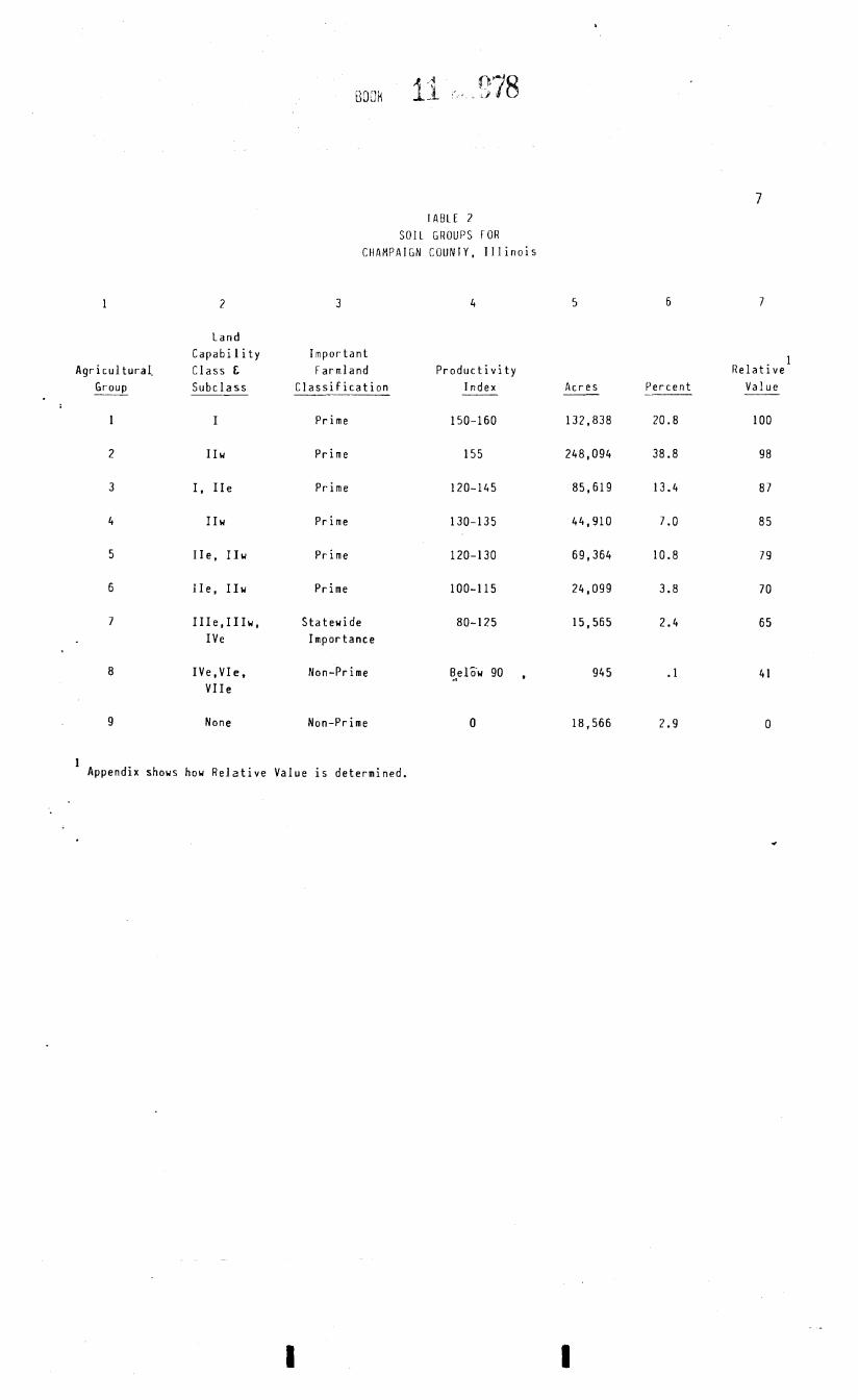
lA8LE 2 S O l L GROUPS FOR
C H A M P A I G N COUNIY, Illinois
Land Capability Important
Agricultural. I
Class & Farmland Productivity Relative Group Subclass Classification Index Acres Percent Value --
1 I Prime 150-160 132,838 20.8 100
2 I I w Prime 155 248,094 38.8 98
3 I, IIe Prime 120-145 85,619 13.4 8 7
4 I I w Prime 130-135 44,910 7.0 85
5 IIe, IIw Prime 120-1 30 69,364 10.8 79
6 IIe, IIw Prime 100-115 24,099 3.8 7 0
7 IIIe,IIIw, Statewide 80-125 15,565 2.4 65 IVe Importance
8 IVe,VIe, Non-Prime 0.~1%~ 90 , 945 . 1 4 1 VIIe
9 None Non-Prime 0 18,566 2.9 0
1 Appendix shows how Relative Value is determined.

I I I. S i t e Assessment
A g r i c u l t u r a l economic v i a b i l i t y o f a s i t e cannot be measured i n i s o l a t i o n from e x i s t i n g and impending land use needs o f Champaign County. The S i t e Asses-sment process provides a system f o r i d e n t i f y i n g impor tan t f a c t o r s , o the r than s o i l s , t h a t a f f e c t the economic v i a b i l i t y o f a s i t e f o r a g r i c u l t u r a l uses.
This s e c t i o n descr ibes each o f 21 S i t e Assessment f a c t o r s t o be considered when a change t o another l a n d use i s proposed i n an area zoned AG-1, Ag r i cu l t u re , AG-2, A g r i c u l - tu re , o r CR, Conservat ion-Recreat ion. The 21 S i t e Assessment f a c t o r s are grouped i n t o t h fo l l ow ing s i x major areas o f cons idera t ion :
A. A g r i c u l t u r a l Land Uses 0. Zoning and P r i o r Governmental Ac t i ons C. C o m p a t i b i l i t y and Impact o f Uses D. Land Use Feasi b i 1 i ty E. Ex is tence o f I n f r a s t r u c t u r e F. Environmental Impact
Based upon c u r r e n t l and use data, land use regu la t i ons , s i t e inspect ion and o the r pe r t i nen t in fo rmat ion , a p o i n t va lue i s determined by ana lyz ing each s i t e assessment f a c - t o r and se lec t i ng a number value t h a t bes t r e f l e c t s t h e q u a l i t y of t he proper ty i n
SITE ASSESSMENT FACTORS, VALUES, AND
A. A q r i c u l t u r a l Land Uses
1. Percentage o f Area i n A g r i c u l t u r a l Uses S i t e .
90% o r more 75% t o 89% 50% t o 74% 25% t o 49% Less than 25%
This f a c t o r i s a major i n d i c a t o r o f t h e
DFSCRIPTIONS OF FACTORS
w i t h i n one and one-hal f (13) m i l es of
a g r i c u l t u r a l character o f an area. Areas i n t h e County t h a t a re dominated by ag r ; cu l t u ra l uses are genera l l y more v iab le f o r f a rm purposes. The d e f i n i t i o n o f " a g r i c u l t u r a l land uses" should be i n t e r p r e t e d t o mean a l l a g r i c u l t u r a l and r e l a t e d uses t h a t can be considered t o be p a r t o f t h e fa rm operat ion. Th i s would i n c l u d e farmland (cropland), pasture lands, o r t imber lands whether o r n o t i n c u r r e n t p roduc t i on and farm residences, barns, and ou t -bu i l d ings . For a more ex tens i ve d e f i n i t i o n of " a g r i c u l t u r e " see Section V D e f i n i t i o n s .
The 1.5 m i l e area o f cons ide ra t i on f o r t h i s f a c t o r was selected f o r two reasons: F i r s t , i n Champaign County, a 1.5 m i l e r a d i u s i s a reasonable and manageable area when analyz ing t h e land use and o v e r a l l c h a r a c t e r i s t i c s o f t he area. Second, t h e S ta te o f I l l i n o i s has s e t one and one-ha l f m i les as t h e j u r i s d i c t i o n a l boundary f o r munic ipal p lanning.
Since t h i s f a c t o r i s a major i n d i c a t o r o f t h e a g r i c u l t u r a l character o f an area, i t has a maximum value of 18.
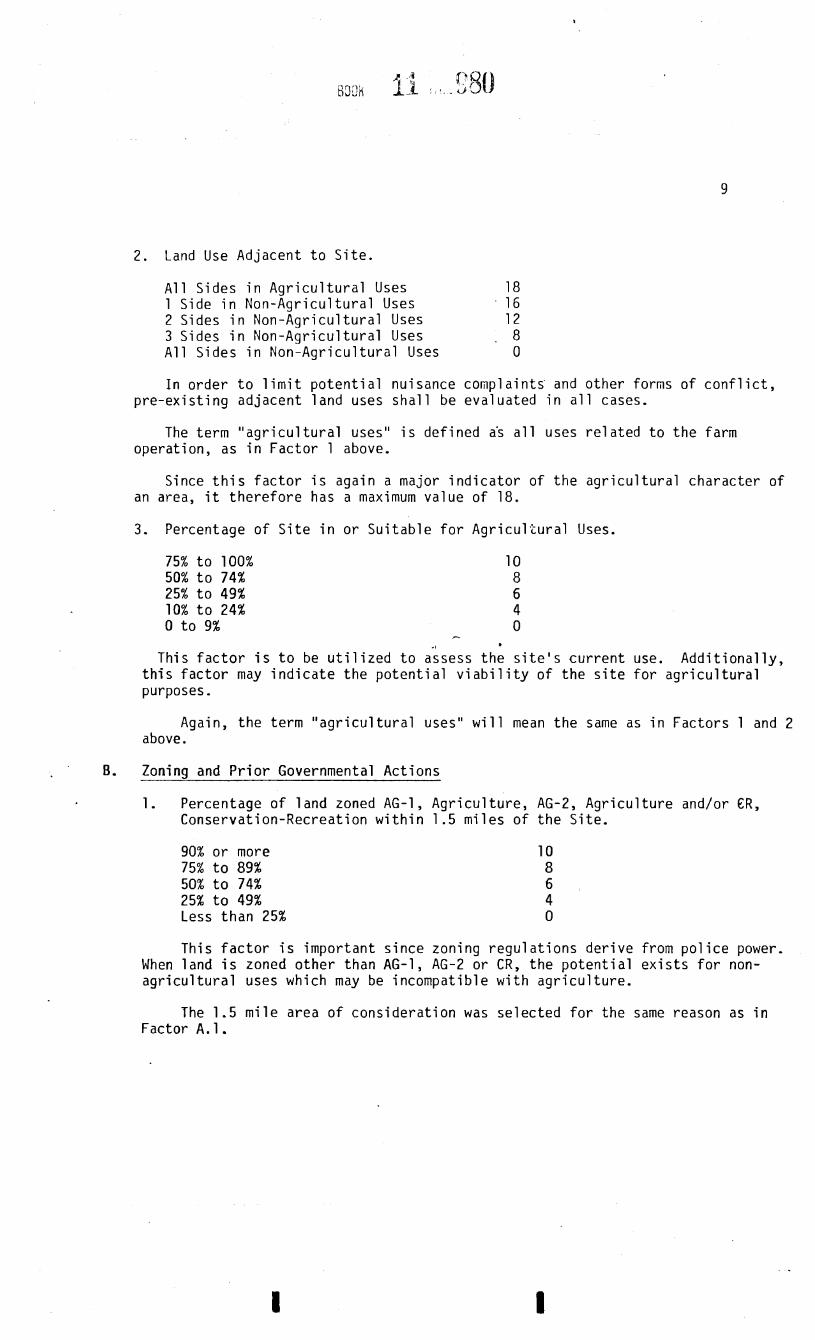
2 . Land Use Adjacent to S i te .
All Sides in Agricultural Uses 18 1 Side in Non-Agricultural Uses 16 2 Sides in Non-Agricultural Uses 1 2 3 Sides in Non-Agricultural Uses . 8 All Sides in Non-Agricultural Uses 0
In order t o l imit potential nuisance complaints' and other forms of conf l ic t , pre-existing adjacent land uses shall be evaluated in a l l cases.
The term "agricultural uses" i s defined a5 a l l uses related to the farm operation, as in Factor 1 above.
Since t h i s factor i s again a major indicator of the agricultural character of an area, i t therefore has a maximum value of 18.
3. Percentage of S i t e in or Suitable for Agricultural Uses.
This fac tor i s t o be u t i l ized to aisess t h e s i t e ' s current use. Additionally, t h i s factor may indicate the potential v i ab i l i t y of the s i t e for agricultural purposes.
Again, the term "agricultural uses" will mean the same as in Factors 1 and 2 above.
. B. Zoning and Prior Governmental Actions
1. Percentage of land zoned AG-1, Agriculture, A G - 2 , Agriculture and/or C R , Conservation-Recreation within 1.5 miles of the Site.
90% or more 75% t o 89% 50% t o 74% 25% t o 49% Less than 25%
This fac tor i s important since zoning regulations derive from police power. When land i s zoned other than A G - 1 , AG-2 or C R , the potential exis ts for non- agricultural uses which may be incompatible with agriculture.
The 1.5 mile area of consideration was selected for the same reason as in Factor A. 1 .
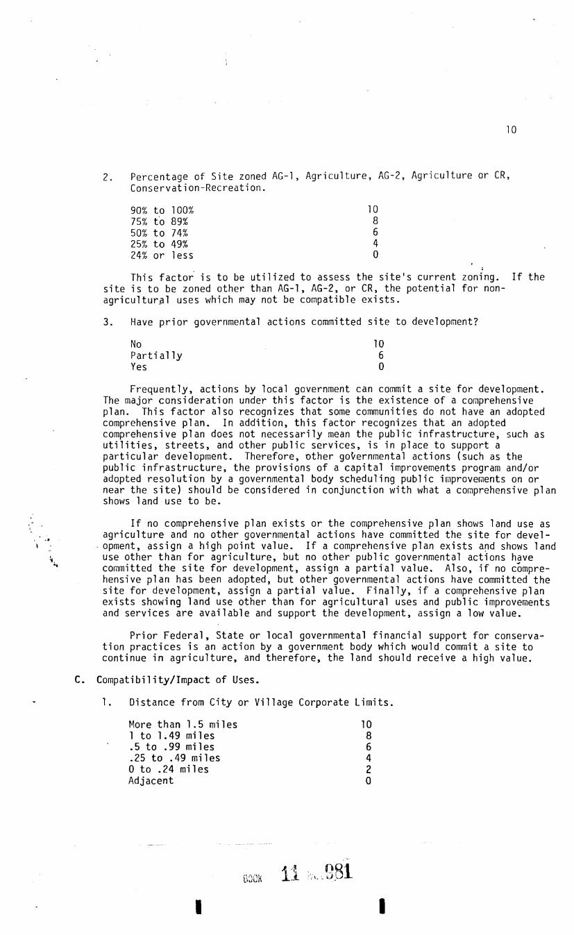
2. Percentage of S i te zoned AG-1, Agriculture, AG-2, Agriculture or C R , Conservation-Recreation.
90% t o 100% 75% t o 89% 50% t o 74% 25% t o 49% 24% o r l e s s
This f a c t o r i s t o be ut i l ized t o assess the s i t e ' s current zoning. If the s i t e i s t o be zoned other than AG-1, A G - 2 , or C R , the potential for non- agricultural uses which may not be compatible ex is t s .
3. Have p r io r governmental actions committed s i t e to development?
No Parti a1 ly Yes
Frequently, actions by local government can commit a s i t e for development. The major consideration under t h i s factor i s the existence of a comprehensive plan. This f ac to r also recognizes that some communities do not have an adopted comprehensive plan. In addition, t h i s factor recognizes tha t an adopted comprehensive plan does not necessarily mean the public infrastructure, such as u t i l i t i e s , s t r e e t s , and other public services, i s in place t o support a par t icular development. Therefore, other goternmental actions (such as the public inf ras t ruc ture , the provisions of a capi tal improvements program and/or adopted resolution by a governmental body scheduling public improvements on or near the s i t e ) should be considered in conjunction with what a comprehensive plan shows land use t o be.
If no comprehensive plan exis t s or the comprehensive plan shows land use as . b agriculture and no other governmental actions have committed the s i t e for devel-
I - - opment, assign a high point value. If a comprehensive plan exis t s and shows land i use other than f o r agriculture, b u t no other public governmental actions have z committed t h e s i t e fo r development, assign a par t ia l value. Also, i f no c&npre-
hensive plan has been adopted, b u t other governmental actions have committed the s i t e for development, assign a par t ia l value. Finally, i f a comprehensive plan exis t s showing land use other than for agricultural uses and public improvements and services a re available and support the development, assign a low value.
Prior Federal, S ta te or local governmental financial support for conserva- t ion pract ices i s an action by a government body which would commit a s i t e t o continue in agricul ture , and therefore, the land should receive a high value.
C. Compatibility/Impact of Uses.
= 1 . Distance from City or Village Corporate Limits.
More than 1 -5 miles 1 t o 1.49 miles .5 t o -99 miles .25 t o -49 miles 0 t o .24 miles Adjacent

A s i t e adjacent t o a c i t y o r v i l l a g e i s more v i a b l e f o r urban development than a s i t e l oca ted many m i les from the nearest urban areas. Because urban uses are g e n e r a l l y considered t o be incompat ib le w i t h a g r i c u l t u r a l pursu i ts , the impact on a g r i c u l t u r a l and r u r a l areas w i l l be minimized when development occurs c lose t o e s t a b l i s h e d urban areas.
2. C o m p a t i b i l i t y o f proposed use and zoning change w i t h surrounding A g r i c u l t u r a l Uses.
Incompati b l e 10 Somewhat Incompat ib le 6 Compatible 0
As i n any l a n d use change, c o m p a t i b i l i t y w i t h surrounding land uses must be determined, Th i s f a c t o r more than any o ther deals w i t h t h e problems encountered when a g r i c u l t u r a l and non -ag r i cu l t u ra l uses are pe rm i t t ed t o mix. It becomes d i f f i c u l t t o determine whether some uses are t o t a l l y compatible. Also t h e dens i ty o r i n t e n s i t y o f s i m i l a r uses become a gray area i n terms o f compati- b i l i t y . C l e a r l y a subd iv i s ion nex t t o an animal confinement opera t ion i s incom- p a t i b l e and can be p red i c ted t o r e s u l t i n c o n f l i c t . However, a l a r g e l o t r e s i - d e n t i a l development loca ted adjacent t o row crop farming might r e s u l t i n l e s s c o n f l i c t . An a g r i c u l t u r a l s u p p l i e r (seed dealer , f e r t i l i z e r dealer, farm implement s a l e s ) cou ld be considered compatible w i t h a g r i c u l t u r e . For these reasons, a p o i n t va lue f o r "somewhat incompat ib le" i s inc luded i n t h i s f a c t o r .
P
The te rm "surrounding" area i n t h i s ins tance w i l l depend on the s i z e o f t h e parcel f o r which a l a n d use change i s proposed. The area t h a t would be d i r e c t l y in f luenced by t h e proposed land use change w i l l be considered "surrounding" area. Each land use change w i l l have a d i f f e r e n t area o f in f luence based on t h e s i z e and i n t e n s i t y o f t h e proposed use.
The Champaign County Zoning Ordinance prov ides f o r a range o f uses pe rm i t t ed . i i n each zoning d i s t r i c t . Refer t o t h e Champaign County Zoning Ordinance f o r t h e
\ - - - r a n g e o f uses i n t h e proposed zoning d i s t r i c t . f
** D. Land Use F e a s i b i l i t y
+
1. S ize o f S i t e Feas ib le f o r Farming.
100 Acres o r More 40 t o 99 acres 20 t o 39 acres 5 t o 19 acres under 5 acres
This f a c t o r recognizes t h a t t h e s i z e o f a pa rce l o f land has an impact on a s i t e ' s v i a b i l i t y f o r a g r i c u l t u r a l purposes. Also, i t i s a r e c o g n i t i o n t h a t modern a g r i c u l t u r e may r e q u i r e l a r g e t r a c t s o f l and f o r e f f i c i e n c y purposes. A t r uck farm o r animal confinement opera t ion would be an except ion.

2. S o i l L i m i t a t i o n s f o r Proposed Use and Proposed Zoning Change.
Severe Moderate t o Severe Moderate S l i g h t t o Moderate S l i g h t
. F r e q u e n t l y , p r o j e c t s are proposed f o r s i t e s where t h e s o i l s present l i m i t a - t i o r k f o r development. These l i m i t a t i o n s can and u s u a l l y do increase the cos t o f t h e proposed development. This f a c t o r recognizes t h e need t o s e l e c t a l t e r n a t i v e s i t e s which do n o t possess severe l i m i t a t i o n s f o r t h e proposed use. Refer t o t h e Champaign County Zoning Ordinance f o r t h e range o f permi t ted uses i n t h e proposed zoning d i s t r i c t .
Sources o f i n fo rma t ion f o r t h i s f a c t o r can be obta ined from t h e Natura l Resource Report prepared by the Champaign County Soi.1 and Water Conservation D i s t r i c t and S o i l Survey o f Champaign County, I l l i n o i s issued March 1982.
3. Depending on t h e proposed use o r p r o j e c t , e i t h e r f ac to r 3.a. o r f a c t o r 3.b., b u t n o t both, w i l l be used. Fac tor 3.a. recognizes e f f o r t s t o s e l e c t s i t e s on t h e l e a s t p roduc t i ve farmland when i t i s necessary t o conver t some a g r i - c u l t u r a l l a n d t o a non -ag r i cu l t u ra l use. Fac to r 3.b. considers whether
. t h e r e i s a need t o rezone a d d i t i o n a l a g r i c u l t u r a l land f o r urban uses. P
a. A1 t e r n a t i v e S i t e s proposed an l e s s i r o d u c t i v e land.
Yes No
Th is f a c t o r can be used f o r s i t e comparison where i t i s essen t i a l t o conver t
.a some a g r i c u l t u r a l l and t o a non -ag r i cu l t u ra l use. Many t imes w i t h a l i t t l e i n -
+ 1 ves t i ga t i on , s i t e s f o r development on l e s s p roduc t i ve a g r i c u l t u r a l land can be
4 proposed as a l t e r n a t i v e s . The t o t a l p o i n t s assigned t o one s i t e can be compared .4 w i t h ' t h e t o t a l p o i n t s determined f o r any number of o the r s i t e s . A l l other,things
being equal, c o n v e r t i n g t h e s i t e w i t h t h e lowest t o t a l p o i n t va lue would have t h e l e a s t adverse impact on t h e a g r i c u l t u r a l base. The s i t e w i t h t h e h ighest va lue should r e c e i v e more p r o t e c t i o n than those w i t h t h e lowest values. Any proposed conversion should consider t he impact on adjacent a g r i c u l t u r a l areas and t h e l o c a l a g r i c u l t u r a l base.
b. Need f o r a d d i t i o n a l 1 and.
Vacant b u i 1 dable 1 and avai 1 ab le 8 L i t t l e b u i l d a b l e 1 and remaining 0
If l a r g e amounts o f app rop r ia te l y zoned land w i t h i n t h e area are vacant and a v a i l a b l e f o r urban use, ass ign a h igh value. If t h e r e i s l i t t l e o r no appro- p r i a t e l y zoned l a n d vacant, assign a low value. A v a i l a b i l i t y o f vacant land depends on a number o f f a c t o r s i n c l u d i n g b u t n o t l i m i t e d t o : zoning, a v a i l a b l e land on t h e market, s i z e o f parcel , l oca t i on , access t o t r a n s p o r t a t i o n modes. Vacant l a n d r e f e r s t o bo th land w i t h no s t r u c t u r e s o r b u i l d i n g s o r land w i t h s t r u c t u r e s o r b u i l d i n g s which cou ld be u t i l i z e d o r removed by t h e proposed user. Th is f a c t o r promotes t h e concept o f i n f i l l i n g , an o b j e c t i v e s p e c i f i e d i n Champaign County 's Land Use Goals and P o l i c i e s .

E. Existence o f I n f r a s t r u c t u r e
1. A v a i l a b i l i t y o f Centra l Sewage System.
More t h a n 1.5 m i l e s .75 t o 1.49 m i l e s .5 t o - 7 4 .25 t o -49 m i l e s 200 f e e t t o .24 m i les 200 f e e t o r l e s s o r o n - s i t e -
The a v a i l a b i l i t y t o a s i t e o f a c e n t r a l sewer system w i t h s u f f i c i e n t capa- c i t y encourages growth and reduces the long- term v i a b i l i t y o f a s i t e f o r a g r i - cu l t u re . The t e r m "on s i t e " i s in tended t o i n c l u d e a sewer system which e x i s t s on the s i t e w i t h no extension necessarv. Accordina t o the I l l i n o i s P r i v a t e Sewage Disposa l Ac t and Code, "new o r Fenovated p r i v a t e sewage disposal systems s h a l l n o t be approved where a p u b l i c s a n i t a r y sewer i s loca ted w i t h i n 200 f e e t o f t h e p r o p e r t y and i s a v a i l a b l e f o r connectioni1.
2. A v a i l a b i l i t y o f Centra l Water System.
More t h a n 1.5 mi l e s 10 .75 t o 1.49 m i l e s 8 .5 t o .74 m i l e s 6 .25 t o .49 m i l e s 4 200 f e e t t o .24 m i l e s - 2 200 f e e t o r l e s s o r o n - s i t e - 0
e
This f a c t o r recognizes t h a t t h e ex is tence of a c e n t r a l water system encour- ages growth and reduces t h e long- term v i a b i l i t y of a s i t e f o r ag r i cu l t u re . As a c e n t r a l wa te r system i s extended i n t o an a g r i c u l t u r a l area, t he character o f t h e area may change and more non -ag r i cu l t u ra l development occur. The term i s in tended t o i n c l u d e water systems which c u r r e n t l y e x i s t o r which w i l cons t ruc ted on t h e s i t e w i t h no need f o r extension.-
3. T ranspor ta t i on .
Inadequate f o r Planned Use and Proposed Rezoning 7 s i t e beyond 1.5 m i l e s from City o r V i l l a g e Corporate L i m i t s
Inadequate f o r Planned Use and Proposed Rezoning, Some minor improvements r e q u i r e d - f i t e beyond 1.5 m i l e s f rom City o r V i 11 age Corpora te L im i t s
Adequate f o r Planned Use and Proposed Rezoning i s i t e beyond 1.5 m i l e s o f City o r V i l l a g e Corporate L i m i t s
"on s i t e " 1 be
... 0
8
6
Inadequate f o r Planned Use and Proposed Rezoniny - s i t e w i t h i n 1.5 m i l e s o f City o r V i l l a g e Corporate L i m i t s 4
Inadequate f o r Planned Use and Proposed Rezoning, Some minor improvements r e q u i r e d - f i t e w i t h i n 1.5 m i l e s of City o r V i 11 age Corpora te L i m i t s
Adequate f o r Planned Use and Proposed Rezoning s i t e w i t h i n 1.5 mi l e s of City o r V i 11 age Corporate L i m i t s
'use a c t u a l road m i l e s t o nearest corpora te 1 i m i t s .
Access t o t r a n s p o r t a t i o n i s a cons ide ra t i on i n t h e l o c a t i o n o f a l l types of uses. The l o c a t i o n o f i n d u s t r i a l , commercial, and r e s i d e n t i a l uses w i t h i n 1.5 m i l es o f e x i s t i n g m u n i c i p a l i t i e s r e s u l t s i n a more e f f i c i e n t movement o f goods and people. The l o c a t i o n o f n o n - a g r i c u l t u r a l uses along r u r a l roads may necessi - t a t e the upgrading and widening o f r u r a l roads, which r e s u l t s i n a f u r t h e r l o s s o f farmland. High volumelhigh speed t r a f f i c . m a y n o t be compatible w i t h a g r i c u l - t u r a l uses.
The t y p e o f road p rov id ing access t o a s i t e whether e x i s t i n g o r t o be provided b y a developer, and the a v a i l a b i l i t y o f t r a n s p o r t a t i o n modes are major f a c t o r s i n de termin ing s u i t a b i l i t y o f t h e planned use o r proposed rezoning. Determining adequacy o f t h e t r a n s p o r t a t i o n i n f r a s t r u c t u r e t o the s i t e depends on a number of f a c t o r s such as load ing (we igh t o f veh i c les and number o f veh ic les) , roadway c a p a c i t y t o handle t r a f f i c volumes, t r a f f i c c o n t r o l devices ( t r a f f i c s igna l s, r e g u l a t o r y and guide signs, pavement marki ngs, e t c . 1, and avai 1 abi 1 i ty o f t r a n s p o r t a t i o n modes (bus, r a i l , major highway). Since t h e type o f t ranspor ta - t i o n i n f r a s t r u c t u r e t o support t h e planned use o r proposed rezoning nay vary among governmental j u r i s d i c t i o n s the re may be a need t o determine adequacy f o r a s p e c i f i c t r a n s p o r t a t i o n component (pavement s t ruc tu re , i n t e r s e c t i o n geonetr ics, number o f lanes, e t c ) . Sources f o r determin ing adequacy of t h e e x i s t i n g t ranspor - t a t i o n i n f r a s t r u c t u r e would be t h e appropr ia te government body having j u r i s d i c - t i o n . Th i s f a c t o r recognizes p lans by t h e developer t o p rov ide t r a n s p o r t a t i o n improvements as w e l l as any e x i s t i n g p lans f o r improvements by a government body.
4. Dis tance of s i t e from f i r e protect i f ln serv ice . t
Not i n f i r e p r o t e c t i o n d i s t r i c t (FPD) 10 I n a FPD, b u t more than 5 m i l es f rom f i r e p r o t e c t i o n s e r v i c e 8
24 t o 5 m i l e s - volunteer 6 0 t o 2.49 m i l e s - volunteer 4 23 t o 5 m i l e s - p a i d 2 0 t o 2.49 m i l e s - p a i d 0
F i r e p r o t e c t i o n requ i res a combinat ion o f equipment, manpower, and a v g i l - a b i l i t y and supply o f water. Th is f a c t o r i s a1 so r e l a t e d t o d is tance between f i r e s t a t i o n and proposed development. Dis tance should be ca l cu la ted by ac tua l road m i les f rom f i r e p r o t e c t i o n se rv i ce t o t h e s i t e .
Environmental Impact of Proposed Use and Zoning Change
1. Impact on Flooding/Drainage
Negati ve Impact 6 Some Impact 4 L i t t l e o r none w i t h spec ia l design
o r p r o t e c t i v e measures prov ided o r r e q u i r e d 2
None 0
This f a c t o r addresses whether t h e proposed use o r zoning change w i l l have impact on ne ighbor ing p r o p e r t i e s from surface runoff; t h i s f ac to r i s a lso con- cerned with env i ronmenta l l y s e n s i t i v e areas such as f l oodp la ins and wetlands. This f a c t o r takes i n t o account whether reasonable p r o v i s i o n s have been made t o c o l l e c t and d i v e r t surface runof f i n o rde r t o reduce t h e l i k e l i h o o d o f damage t o ad jo in ing p r o p e r t i e s . The s e l e c t i o n and design o f measures w i l l depend on

vary ing l o c a l c o n d i t i o n s such as s o i l s , topography, phys ica l features and t h e extent of imperv ious surface. Refer t o Champaign County Zoning Ordinance f o r t h e range o f p e r m i t t e d uses i n t he proposed zoning d i s t r i c t .
2. Impact on h i s t o r i c , c u l t u r a l , unique o r impor tan t vegeta t ion areas, o r o the r areas o f eco log i ca l importance.
Negat ive impact Some impact No impact
S i tua t i ons .may a r i s e when a land use change w i l l adversely a f f e c t unique h i s t o r i c a l , c u l t u r a l o r vegeta t ion areas. These i n c l u d e unusual o r l o c a l l y important w i l d l i f e o r vegetat ion, and areas o f h i s t o r i c s i g n i f i c a n c e such as ( 1 ) a s i t e o r s t r u c t u r e where an important h i s t o r i c event occurred (landmark), ( 2 ) a b u i l d i n g o r an area o r d i s t r i c t which i s e i t h e r a r c h i t e c t u r a l l y unique o r s i g n i f i c a n t i n l o c a l o r broader t r a d i t i o n s , and, ( 3 ) an area o r s i t e which may y i e l d s i g n i f i c a n t archeologic da ta o r evidence. Refer t o Champaign County Zoning Ordinance f o r t h e range o f uses i n t he proposed zoning d i s t r i c t .
3. Impact on r e c r e a t i o n and open spaces. if
Negat ive impact 6 Some impact 4 No impact r- 0
I
L i m i t i n g development i n envi ronmental ly s e n s i t i v e areas may prov ide oppor- t u n i t y f o r r e c r e a t i o n a l open space and p r o t e c t n a t u r a l areas. Also, a land use change may r e s u l t i n c o n f l i c t i n g uses and prevent o r reduce p u b l i c access f o r r e c r e a t i o n a l purposes. This f a c t o r inc ludes t h e phys i ca l space, serv ices and f a c i l i t i e s . Re fe r t o t h e Champaign County Zoning Ordinance f o r t h e range o f uses i n the proposed zoning d i s t r i c t .
4. Impact on Water Qua1 i t y
Severe Moderate t o Severe Moderate S l i g h t t o Moderate S l i g h t
Th i s f a c t o r r e f l e c t s impacts on t h e q u a l i t y of sur face water and ground water. Surface water r e f e r s t o streams o r sur face depressions such as lakes and r e s e r v o i r s ( n a t u r a l o r man-made). Groundwater begins as p r e c i p i t a t i o n seeps downward i n t o t h e ground through t h e s o i l s , some se rv ing t h e important needs o f vegeta t ion as s o i l moisture and some p e r c o l a t i n g deeper i n t o t h e ground becoming our groundwater resources. Res ident ia l , commercial and i n d u s t r i a l developments w i l l have v a r y i n g degrees o f impact on sur face and ground water q u a l i t y . Design fea tu res may compensate f o r impacts on water q u a l i t y . Refer t o Champaign County Zoning Ordinance f o r t h e range o f uses i n t h e proposed zoning d i s t r i c t .

5. Impact on Water Supply
Severe Moderate t o Severe Moderate S l i g h t t o Moderate S l i g h t
A l though wa te r use as a dones t i c . supp l y may have f i r s t p r i o r i t y , i t i s o n l y one of t h e m u l t i p l e uses. Much wate r must be a v a i l a b l e f o r a g r i c u l t u r a l c rops and animals, commercial and i n d u s t r i a l development, waste t reatment , f i r e p ro - t e c t i o n , r e c r e a t i o n , and f i s h and w i l d l i f e . T h i s f a c t o r a l s o r e f l e c t s impacts on bo th ground and s u r f a c e water. However, most o f t h e water use f o r r e s i d e n t i a l , commercial and i n d u s t r i a1 developments i n t h e County comes from ground water. Whi le Champaign County i s b lessed w i t h abundant ground water resources, these water resources a r e f i n i t e and a r e n o t d i s t r i b u t e d un i fo rmly . The term water supply o r wa te r use i m p l i e s water wi thdrawals . The p r i n c i p a l r e q u i s i t e f o r w i thdrawa l use i s t h a t water must be taken f rom a groundwater o r su r face water source and conveyed t o t h e p l ace of use. Res iden t i a1 , comrnerci a1 and i n d u s t r i a1 developments w i l l have va ry i ng degrees o f wa te r w i thdrawa ls . Refer t o t h e champaign County Zoning o rd inance - fo r t h e range o f p e r m i t t e d uses i n t h e proposed zoning d i s t r i c t . A l s o r e f e r T a t e r Use Ac t of 1983 when wi thdrawals can reasonably be expected t o occur ?n excess of 100,000 g a l l o n s on any day f rom any new p o i n t a t which underground wate r i s ~ d i v e r t e d f r om i t s n a t u r a l s t a te .

I V . I n s t r u c t i o n s f o r Ca lcu la t i ng the Tota l Land Eva lua t ion and S i t e Assessment Value f o r a S i te .
The f o l l o w i n g a re i n s t r u c t i o n s t o determine the t o t a l Land Evaluat ion and S i t e Assessment value f o r t h e parce l i n quest ion. The Land Eva lua t ion p a r t and S i t e Assessment p a r t each requ i re separate c a l c u l a t i o n s .
A. Land E v a l u a t i o n Value
he Land E v a l u a t i o n value w i l l be prov ided by t h e Champaign S o i l and Water Conser- v a t i o n D i s t r i c t o f f i c e t o t h e Champaign County Zoning o f f i c e when a p e t i t i o n i s f i l e d f o r a map amendment ( rezon ing ) . Otherwise, t h e Land Eva lua t ion value can be ca l cu la ted by working through t h e f o l l o w i n g steps:
1. O u t l i n e t r a c t o f l and t o be rezoned on a s o i l s map. S o i l naps can be found i n the S o i l Survey o f Champaign County and are a l so a v a i l a b l e a t t he Champaign County Soi 1 and Water Conservat ion D i s t r i c t o f f i c e .
2. Acreage o f i n d i v i d u a l s o i l types w i t h i n area o f concern can be obtained by us ing a p lan ime te r o r o the r appropr ia te method o r can be obtained from t h e Champaign County S o i l and Water Conservat ion D i s t r i c t .
3. From Column 9 o f Table 1, s e l e c t t h e appropr ia te A g r i c u l t u r a l Value Group f o r each s o i l t ype and l i s t them i n a column t o t h e r i g h t of t h e s o i l type.
4. From Column 7 o f Table 2, s e l e c t t h e r e l a t i v e value fo r each corresponding a g r i c u l t u r a l group.
5. M u l t i p l y t h e number o f acres by t h e r e l a t f v e value f o r each s o i l type. 6. Tota l t h e product (ac re x r e l a t i v e Galue) of each s o i l t ype and d i v i d e t h i s
number b y t h e t o t a l number o f acres i n area of concern. This f i g u r e i s t h e value o f t h e Land Eva lua t ion p a r t o f t h e LESA system. The maximum number o f p o i n t s p o s s i b l e f o r any g iven pa rce l i s 100.
7. Example: an 80 acre t r a c t o f land has th ree s o i l types: 154A - Flanagan, 152 - Drummer and 56B - Dana. Based on t h e fo l l ow ing ca l cu la t i ons , t he Value f o r t he Land Eva lua t i on p a r t would be 93.
1 2 3 Product t .*.Soils
-- AG Group Re1 a t i ve Val ue Acres (Re la t i ve Value X Acres)
i 4
354A 1 1 00 2 0 2,000 152 2 98 2 0 1,960 56B 3 8 7 40 3,480
m m ' ~ ~ r i c u l t u r a l Group - Obtained f rom Table 1. ' ~ e l a t i v e Value - Obtained f rom Table 2. 3 ~ c r e s - use a p lan ime te r o r can be obta ined f rom t h e Champaign County S o i l and Water
Conservation D i s t r i c t .
Land Eva lua t i on = T o t a l o f Product > To ta l number o f acres i n parcel . - - 7440 - . 80 = 93
B. S i t e Assessment Value
To e s t a b l i s h t h e S i t e Assessment p o i n t value of t h e g iven parcel , work through the f o l l o w i n g steps:
1. Based upon l o c a l land use in format ion, s i t e inspect ion , and o ther p e r t i n e n t data, assess t h e s i t e f o r each f a c t o r shown i n Sect ion 111.
2. A p o i n t va lue f o r each f a c t o r i s determined by analyz ing each S i t e Assess- ment f a c t o r and choosing t h e category t h a t bes t s u i t s t he p rope r t y i n ques t ion .
3. Add a l l f a c t o r values t o a r r i v e a t a S i t e Assessment sub to ta l . The maximum number o f poss ib le p o i n t s f o r any g iven parce l i s 200.
C . Assessing a S i t e f o r i t s A g r i c u l t u r a l V i a b i l i t y
Once t h e value f o r t h e Land Eva lua t ion p a r t and S i t e Assessment p a r t are obtained, add bo th values f o r t h e t o t a l p o i n t s f o r each s i t e .
The t o t a l maximum p o i n t s poss ib le f o r any s i t e a re 300. The Land Eva lua t ion may be assigned a maximum o f 100 po in t s , and t h e S i t e Assessment nay be assigned a maximum o f 200 po in t s .
The f o l l o w i n g breakdown should be used i n eva lua t i ng a rezoning from AG-1, A g r i c u l t u r e , AG-2, Ag r i cu l t u re , and/or CR, Conservat ion-Recreat ion t o another zoning d i s t r i c t f o r p r o t e c t i o n o f Ag r i cu l t u re :
220 - 300 - Very High Rat ing f o r P r o t e c t i o n 200 - 219 - High Rat ing f o r P r o t e c t i o n 180 - 199 - Moderate Rat ing fo r P r o t e c t i o n 179 o r below - Low Rat ing f o r P r o t e c t i o n
fi
The h i g h e r t h e t o t a l p o i n t s accr&d f o r a* s i t e , t h e more a g r i c u l t u r a l l y v i a b l e t h e g iven s i t e w i l l be. When cons ider ing a number o f s i t e s f o r a n o n - a g r i c u l t u r a l use, s e l e c t i o n o f t h e s i t e w i t h t h e lowest p o i n t score w i l l u s u a l l y r e s u l t i n p r o t e c t i o n o f t h e bes t a g r i c u l t u r a l land i n t h e most v i a b l e l oca t i ons .

19 Glossary
AGRICULTURE: The growing, harves t ing and s t o r i n g o f crops i n c l u d i n g legumes, hay, g ra in , f r u i t and t r u c k o r vegetable crops, f l o r i c u l t u r e , h o r t i c u l t u r e , mushroom growing, orchards, f o r e s t r y and t h e keeping, r a i s i n g and feeding o f l i v e s t o c k o r p o u l t r y , i n c l u d i n g da i r y ing , pou l t ry , ' sw ine , sheep, beef c a t t l e , pony and horse product ion, f u r farms, and f i s h and w i l d l i f e farms; farm b u i l d i n g s used f o r growing, harves t ing and prepar ing crop products f o r market, o r f o r use on t h e farm; roadside stands, farm b u i l d i n g s f o r s t o r i n g and p r o t e c t i n g farm machinery and equipment from t h e elements, f o r housing l i v e s t o c k o r p o u l t r y and f o r p repar ing l i v e s t o c k o r p o u l t r y products f o r market; fa rm dwe l l i ngs occupied by farm owners, operators, tenants o r seasonal o r year- round h i r e d farm workers. It i s in tended by t h i s d e f i n i t i o n t o i nc lude w i t h i n t h e d e f i n i t i o n o f a g r i c u l t u r e a1 1 types o f a g r i c u l t u r a l operat ions, b u t t o exclude there f rom i n d u s t r i a l operat ions such as a g r a i n e leva to r , canning o r slaughterhouse, wherein a g r i c u l t u r a l products produced p r i m a r i l y by o the rs are s to red o r processed. Source: Champaign County Zoning Ordinance.
AG-1, AGRICULTURE: The AG-1, A g r i c u l t u r e D i s t r i c t i s intended t o p r o t e c t t he areas o f t h e County where s o i l and topographic cond i t i ons are best adapted t o t h e p u r s u i t o f a g r i c u l t u r a l uses and t o prevent t he admixture o f urban and r u r a l uses which would c o n t r i b u t e t o t h e premature te rm ina t i on o f a g r i c u l t u r a l p u r s u i t s . Source: Champaign County Zoning Ordinance.
AG-2, AGRICULTURE: The AG-2, A g r i c u l t u r e D i s t r i c t i s in tended t o prevent scat- t e red i n d i s c r i m i n a t e urban development and t o preserve t h e a g r i c u l t u r a l na tu re w i t h i n areas which are predominant ly vacant and which p resen t l y do no t demon- s t r a t e any s i g n i f i c a n t p o t e n t i a l f o r development. This d i s t r i c t i s in tended g e n e r a l l y f o r a p p l i c a t i o n t o areas w i t h i n one and one-hal f (13) m i l es o f e x i s t i n g communities i n t h e County. Source: Champaign County Zoning Ordinance.
AGRICULTURAL LAND: Land i n farms regu l a r l y used f o r a g r i c u l t u r a l product ion. The t e r n incTudes a l l l and devoted t o c rop o r l i v e s t o c k en terpr ises , f o r example,
- t h e farmstead lands, drainage d i tches , water supply, cropland, pasture land, o r t imber land (whether o r n o t i n c u r r e n t p roduct ion) , and graz ing land e f every k i n d i n farms.
CAPABILITY CLASS: C a p a b i l i t y c lasses are broad groupings o f s o i l mapping u n i t s t h a t have s r m i l a r p o t e n t i a l s and/or l i m i t a t i o n s and hazards. These classes are u s e f u l as a means o f i n t r o d u c i n g the map users t o more d e t a i l e d i n f o r m a t i o n on a s o i l s map. The c lasses show t h e l oca t i on , amount and general s u i t a b i l i t y o f t h e s o i l s f o r a g r i c u l t u r a l use.
The n a t i o n a l c a p a b i l i t y c l a s s i f i c a t i o n shows s o i l s groupings i n e i g h t c l asses:
CLASS I - s o i l s have few l i m i t a t i o n s t h a t r e s t r i c t t h e i r use. CLASS I 1 - s o i l s have some l i m i t a t i o n s t h a t reduce t h e choice o f p l a n t s
o r r e q u i r e moderate conserva t ion prac t ices . CLASS I 1 1 - s o i l s have severe l i m i t a t i o n s t h a t reduce t h e choice o f p l a n t s
o r r e q u i r e spec ia l conserva t ion p rac t i ces , o r both. CLASS I V - s o i l s have very severe l i m i t a t i o n s t h a t reduce t h e choice o f
p jan ts , r e q u i r e very c a r e f u l management, o r both. CLASS V - s o i l s have l i t t l e o r no e ros ion hazard b u t have o the r
l i m i t a t i o n s i m p r a c t i c a l t o remove t h a t l i m i t t h e i r use l a r g e l y t o pasture, range, woodland, o r w i l d l i f e food and cover.
CLASS V I - s o i l s have severe l i m i t a t i o n s t h a t make them genera l l y unsu i ted t o c u l t i v a t i o n and l i m i t t h e i r use l a r g e l y t o pasture, range, woodland, o r w i l d l i f e food and cover.

20 CLASS V I I - s o i l s have very severe l i m i t a t i o n s t h a t make then unsui ted t o
c u l t i v a t i o n and t h a t r e s t r i c t t h e i r use l a r g e l y t o graz ing, woodland, o r w i l d l i f e .
CLASS V I I I - s o i l s and landforms have l i m i t a t i o n s t h a t preclude t h e i r use f o r commercial p l a n t p roduct ion and r e s t r i c t t h e i r use t o rec rea t i on , w i l d l i f e , o r water supply, o r t o aes the t ic purposes.
The s o i l s i n Champaign County f a l l i n t o c a p a b i l i t y c lasses I t h r u I V , V I , and V I I .
CAPABILITY SUBCLASS: Subclasses are groups o f c a p a b i l i t y u n i t s w i t h i n classes t h a t have t h e same k inds o f dominant l i m i t a t i o n s f o r a g r i c u l t u r a l use as a r e s u l t o f s o i l and c l ima te . The subclass prov ides in fo rmat ion about both t h e degree and k i n d o f l i m i t a t i o n . There are two subclasses t h a t are used w i t h the s o i l s i n Champaign County:
Subclass ( e ) e ros ion - app l i es t o s o i l s where t h e s u s c e p t i b i l i t y t o e ros ion i s t h e dominant problem o r hazard i n t h e i r use. Erosion s u s c e p t i b i l i t y and past e ros ion damage are t h e major s o i l f a c t o r s f o r p l a c i n g s o i l s i n t h i s subclass.
Subclass (w) excess water - app l i es t o s o i l s where excess water i s t he dominant hazard o r l i m i t a t i o n i n t h e i r use. Poor s o i 1 drainage, wetness, h i g h water t ab le , and ove r f l ow a re t h e c r i t e r i a f o r determin ing which s o i l s belong i n t h i s subclass.
4 B
C a p a b i l i t y CLASS I has no subclass.
CAPITAL II4PROVEMENTS PROGRAM: A proposed t ime tab l e o r schedul e o f a1 1 f u t u r e c a p i t a l improvements t o be c a r r i e d o u t du r ing a s p e c i f i c pe r iod and l i s t e d i n order o f p r i o r i t y , together w i t h c o s t est imates and t h e a n t i c i p a t e d means of f i n a n c i n g each p r o j e c t .
.a t - COMPREHENSIVE PLAN: A p l a n in tended t o guide t h e growth and development 0 f . a com-
munity o r r e g i o n and one t h a t i nc ludes ana lys is , recommendations and proposals i~ f o r t h e comnuni ty ' s 1 and use, popu la t ion , economy, housing t r a n s p o r t a t i b , and
community f a c i l i t i e s .
CONSERVATION: The preserva t ion , p ro tec t i on , and r e s t o r a t i o n o f na tu ra l resources and ecosystems.
CR, CONSERVATION-RECREATION: The CR, Conservat ion-Recreat ion D i s t r i c t i s in tended t o p r o t e c t t h e p u b l i c h e a l t h by r e s t r i c t i n g development i n areas subject t o f requent o r p e r i o d i c f l oods and t o conserve t h e n a t u r a l and scenic areas g e n e r a l l y a long t h e major stream networks of t h e County. Source: Champaign County Zoning Ordinance.
DISTRICT: A s e c t i o n o f t h e County /C i ty /V i l lage i n which zoning regu la t i ons and standards a r e uni form. Source: Champaign County Zoning Ordinance. See Champaign County Zoning Ordinance f o r General I n t e n t of a l T Z o n i n g D i s t r i c t s .
FARMLAND OF STATEWIDE IMPORTANCE: Th is l and i s of s ta tewide importance f o r t h e product ion o f food, feed, f i b e r , fo rage and o i l s e e d crops. Generally, a d d i t i o n a l farmlands o f s ta tewide importance i n c l u d e those t h a t are nea r l y prime fa rmland and t h a t economical ly produce h i g h y i e l d s o f crops when t r e a t e d and managed according t o acceptable farming methods. Some may produce as h igh a y i e l d as pr ime farmlands if c o n d i t i o n s a re favorable.

2 1 I N F R A S T R U C T U R E : The basic ins ta l la t ions and f a c i l i t i e s on which the continuance
and growth of a community depends such as: roads, schools, u t i l i t i e s , trans- portation and communication systems.
LOT: t! designated parcel, t r ac t or area of land established by p la t , subdivision - or as otherwise permitted by law, to be used, developed or bui l t upon as a
unit . SOURCE: Champaign County Zoning Ordinance.
PRIME FARMLAND: Prime farmland i s land that i s best suited to food, feed, forage, f iber and oi 1 seed crops. I t nay be crop1 and, pasture, woodl and, or other land, but i t i s not urban and bui 1 t u p 1 and or water areas. I t e i ther i s used for food or f ibe r or i s available ;for those uses. The soil qua l i t ies , growing season, and moisture supply are those needed for a well managed soil economically t o produce a sustained high yield of crops. Prime farmland produces the highest yields with minimum inputs of energy and economic resources, and farming i t resu l t s in the leas t damage t o the environment.
Prime farmland has an adequate and dependable supply of moisture from precip- i t a t ion or i r r iga t ion . The temperature and growing season are favorable. The level of acidi ty or a lka l in i ty i s acceptable. Prime farmland has few or no rocks and i s permeable to water and a i r . I t i s not excessively erodible or saturated with water for long periods and i s not frequently flooded during the growing season. The slope ranges mainly from 0 t o 5 percent.
PRODUCTIVITY INDEX: Productivity indexes for grain crops express the estimated yields of the major grain crops as a percentage of the average yields obtained under basic management. Soil productivity i s strongly influenced by the capacity of a so i l t o supply the nutrient and soil -stored water needs of a growing crop in a given climate. -Source: ' Soil Productivity in I l l i no i s , Circular 11 56, University of I1 1 i nors, Coll ege of Agriculture, Cooperative Extension Office.

V I . APPENDIX

D E T E R M I N I N G R E L A T I V E V A L U E C H A M P A I G N COUNTY
A D J U S T E D P R O D U C T I V I T Y I N D E X A G R I C U L T U R A L F O R T H E GROUP D I V I D E D B Y PRODUCT OF
GROUP THE H I G H E S T A D J U S T E D R E L A T I V E PRODUC- T I M E S 100 P R O D U C T I V I T Y I N D E X T I V I T Y I N D E X
R E L A T I V E V A L U E

WORKSHEETS FOR DETERMINING R E L A T I V I VALUES pp -- - -- - -- -
GROUP I
Map Symbol Productivity Index X Acres - Product
Total: 132,838 21,007,010
Total product total acres = weighted average. . 21,007,010 f 132,838 = 158.14 (Round to 158)
Weighted average highest weighted average of all groups (158) X 100 = Relative Value 158 -
I 158 X 100 = 100 -
GROUP I1
Map Symbol Productivity Index X Acres
Map Symbol Productivity Index
Total:
GROUP I11
Acres
23,839
1,476
8,881
16,069
5,330
1,426
1,797
3,213
22,269
1,319
85,619
0 85,619 = 137.94 (Round to 138) 138 f 158 X 100 = 87.3 (Round to 87) -
Product
Product
3,218,265
191,880
1,198,935
2,330,005
746,200
192,510
251,580
385,560
3,117,660
178,065
11,810,660

M a p Symbol --
6 7
P roduc t i v i t y Index
135
130
135
,130
135
130
130
GROUP I V .-
X Acres
2,252
1,001
1,545
Total : 44,910
6,004,480 1 44,910 = 133.7 (Round t o 134) 134 f 158 X 100 = 84.81 (Round t o 84) - -
GROUP V
Map Symbol
1348
1468
2218
22382
P r o d u c t i v i t y Index
120
130
120
120
120
125 ,
120
120
125
125
120
X Acres - - t *
1r244
Total : 69,364
Product
304,020
130,130
364,905
827,840
Product
149,280
4,035,070
924,960
1,337,040
328,200 4
186,125
221,040
635,880
459,750
301,250
93,360
8,671,955
8,671,955 f 69,364 = 125.02 (Round t o 125) 125 i 158 X 100 = 79.11 (Round t o 79)
=

Map Symbol
23A
238
278
918
1318
1508
1948
206
302
3878
402
4488
GROUP VI
P r o d u c t i v i t y I ndex X A c r e s -- .
105 1,005
Map Symbol
T o t a l : -$ 24,099 P
2,640,495 24,099 = 109.56 (Round t o 110)
9 5
80
100
105
9 0 e s t i m
105
105
90
120
105
110 i 158 X 100 = 69.62 (Round t o 70) - -
GROUP VII
P r o d u c t i v i t y I n d e x X Ac res
755
429
8 90
5,821
a t e d 330
3,044
1,867
278
778
1,054
275 4 4 -
T o t a l : 15,565
(Round t o 103) 103 i 158 X 100 = 65.2 (Round t o 65) - -
P r o d u c t --
105,525
65,520
29,370
P r o d u c t
71,725

Map Symbol - P r o d u c t i v i t y I n d e x
2 7 E 2 6 0 e s t i m a t e d
2 4 1 0 3 5 0 e s t i m a t e d
G R O U P VIII
X A c r e s
Total:
6 1 , 3 5 0 f 9 4 5 = 64.92 ( R o u n d t o 65) 6 5 1 5 8 X 1 0 0 = 41.14 ( R o u n d t o 4 1 ) -
G R O U P IX
M a p S y m b o l s f o r G r o u p I X a r e u r b a n built-up a r e a s o r water.
P r o d u c t i v i t y i n d i c e s a n d p r o d u c t w o u l d b e zero.
R e l a t i v e V a l u e i s 0. -
- P r o d u c t