high peak borough council development control … 1... · 2018-10-01 · 1 high peak borough...
TRANSCRIPT

1
HIGH PEAK BOROUGH COUNCILDEVELOPMENT CONTROL COMMITTEE
Date 8th October 2018
Application No:
HPK/2018/0191
Location Samas Roneo Ltd, Glossop Road, Gamesley, GlossopProposal Approval of Reserved Matters for residential developmentApplicant Pendragon Estate DevelopmentsAgent Patrick Rattigan PWR PlanningParish/ward St John’s Ward Date registered 02/05/2018If you have a question about this report please contact: James Stannard, Tel. 01298 28400 extension 4298, [email protected]
1. SUMMARY OF RECOMMENDATION
APPROVE with Conditions
1. REASON FOR COMMITTEE DETERMINATION
1.1 The application is being brought before Planning Committee due to this Reserved Matters application relating to Major Development.
2. DESCRIPTION OF THE SITE AND ITS SURROUNDINGS
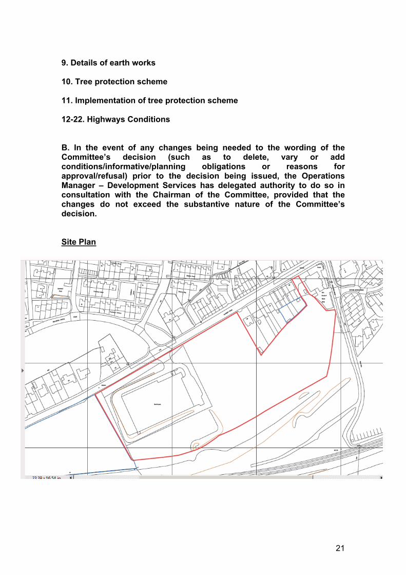
2.1 This application relates a parcel of land measuring approximately 2.8 hectares which was home to the former Samas Roneo furniture warehouse (demolished following a prior notification application under DET/2018/0002), and adjoining open land, south of Glossop Road. Gamesley.
2.2 This reserved matters application seeks to agree layout, scale, appearance and landscaping following the grant of outline planning consent HPK/2014/0665 in 2015 for residential development and the resolution to approve a revision to two planning conditions in September pursuant to the recent Section 73 application ref HPK/2018/0178.
2.3 The site is bounded to the north by the Glossop Road and a row of residential properties on its northern side. This boundary is characterised by an intermittent hedgerow. To the south, at the bottom of a steep embankment, beyond an area of open land, are the Manchester-Glossop railway line, and an area designated within the Local Plan Policies Map for Gamesley Railway Station.

2
2.4 The neighbouring area of open land to the south and east is subject to a pending application (HPK/2017/0655) for the levelling of the site for the purposes of providing a level hardstanding surface.
2.5 The parcel of land to the west of the site is allocated for residential development under Policy H2 of the Local Plan (Land at Gamesley Sidings) and is subject to a separate full planning application (HPK/2018/0272) which is being considered by the Council.
3. DESCRIPTION OF THE PROPOSAL
3.1 This application seeks the approval for all reserved maters which relate to HPK/2014/0665. Matters for assessment include scale, layout, landscaping and appearance.
3.2 The access to the site was amended following a Section 73 Application being approved which members resolved to approve under HPK/2018/078. As such, the vehicular access to the site is now from Glossop Road, further west than the original access to the Samas Roneo site.
3.3 The proposed residential scheme comprises 93 dwellings made up of the following housing mix:
6no. 1 bed apartments12no. 2 bed apartments14no. 2 bed houses30no. 3 bed houses31no. 4 bed houses
3.4 The proposed development proposes a provision of 30% affordable housing minus the vacant building credit, introduced in 2014 to encourage development on brownfield land. Accordingly this equates to 20 units being provided on site; 10 x 2 bedroom properties, and 10 x 3 bedroom properties.
3.5 The proposed development comprises a mixture of predominantly 2 and 2.5 storey residential properties, in addition to a small number of 3 storey apartment blocks.
3.6 The application has been accompanied by the following documents and technical information:
- Design and Access Statement- Planning Statement- Proposed Site Plan (as revised)- Proposed House Types Plans and Elevations (as revised)- Street Scenes (as revised)- Refuse Plan (as revised)- Boundary Treatment Plan (as revised)

3
- General Landscaping Arrangements (as revised)- Planting Schedule- Tree Schedule- Affordable Housing Plan (as revised)- Transport Assessment- Travel Plan- Flood Risk and Drainage Report- Ecological Impact Assessment - Written Scheme of Investigation (WSI)
4. RELEVANT PLANNING HISTORY
4.1 The following applications are relevant to this planning application
HPK/2004/0255 Residential Development (Withdrawn)
HPK/2004/0684 Residential Development – Appeal lodged for non-determination later withdrawn
HPK/2005/0253 37 detached, semi-detached and mews properties (Refused and dismissed at appeal)
HPK/2011/0456 Outline application for 93 houses (Withdrawn November 2011)
HPK/2012/0026 Outline consent for demolition of warehouse and residential development of up to 93 dwellings and associated works (Approved 2012)
HPK/2014/0665 Outline Planning Permission for proposed demolition of warehouse and residential development of land and associated works (Approved 13th April 2015)
DET/2018/0002 Proposed demolition of former industrial warehouse, to be replaced with residential development on site and land either side of former warehouse (Prior Approval Granted 28th March 2018)
HPK/2018/0178 Variation of Conditions 4 and 9 relating to HPK/2014/0665 (Pending Decision)
HPK/2018/0272 Full Planning Permission for 44 homes and apartments (Adjacent site - Pending Decision)
5. PLANNING POLICIES RELEVANT TO THE DECISION
High Peak local Plan 2016

4
S1 Sustainable Development PrinciplesS1a Presumption in favour of Sustainable DevelopmentS2 Settlement HierarchyS3 Strategic Housing DevelopmentS5 Glossopdale Sub-Area StrategyEQ5 BiodiversityEQ6 Design and Place MakingEQ7 Historic EnvironmentEQ9 Trees Woodland and HedgerowH3 New Housing DevelopmentH4 Affordable HousingCF6 Accessibility and Transport
National Planning Policy Framework
Achieving Sustainable Development Chapter 1Delivering a Sufficient Supply Of Homes Chapter 5Promoting Sustainable Transport Chapter 9Achieving Well Designed Places Chapter 12
6. CONSULTATIONS CARRIED OUT
Site notice Expiry date for comments: 11th June 2018Neighbour letters Expiry date for comments: 25th May 2018Press Notice Expiry date for comments: 7th June 2018
Neighbours
6.1 2 representations objecting to the application have been received. The key material planning objections to this application are summarised as follows:
Number of dwellings excessive for the site. Extra volume on traffic from proposed site will lead to congestion and
increase in accidents and impact upon highway safety
Consultees
Highways Authority – 18th June 2018
Access location has moved to the south west of its original location. Modified access design is not sufficiently detailed enough for the Authority to fully consider.
Inconsistencies between illustrative Masterplan, general arrangements and proposed Site Plan drawings.
Condition 5 of Outline consent secured the provision and protection of a bus route opportunity through the site to support the long term Local Plan commitment of

5
Gamesley Railway Station. The current widths of internal roads, 5.5m reducing to 4.5m in places would be unlikely to support this.
Condition 12 of the Outline consent required a roadside footway to be created alongside site frontage to Glossop Road. It is noted that this has been relocated to within the site. Whilst the principle of this is likely to be acceptable, it will concentrate movements in two locations, which would need to be supported by appropriate pedestrian facilities – not shown on the proposed plans. Any crossing points would need to avoid any conflict with driveways on the opposite side of Glossop Road.
The applicant will need to demonstrate that the turning heads at the head of the cul-de-sacs can accommodate the turning manoeuvre of a refuse vehicle, via swept path analysis, based on an 11.6m vehicle and the turning manoeuvre should be contained wholly within the carriageway area, with at least 0.3m relief from any kerb-lines.
A roadside footway should be provided on the eastern side of the street fronting plots 40 and 48, to cater for pedestrian movements.
Access to private parking areas should be laid out as a vehicle dropped crossing point, to provide a continuous priority for pedestrian movement – the access pojnts serving plots 18-26 and 51-59 should therefore be modified to reflect this.
The access and driveway arrangements associated with plots 17 and 50 are likely to involve awkward manoeuvring to and from the estate street; revised arrangements should be considered for these plots.
The garages associated with plot 43 protrudes into the pedestrian footway link, reducing its effective width. Modified arrangements to the building or footway should be considered in this location.
Plot 93 appears to only have a single car parking space associated with it. This could lead to on-street parking at an undesirable location, especially when considering future phases of development.
In its currently submitted format there are a number of issues that will need to be resolved before the Highway

6
Revised Highways Comments – 24th Sept
Authority may be in a position to sanction the current reserved matters application.
Further to previous highway comments the applicant has modified the Glossop Road junction to provide more acceptable junction geometry, the applicant has also undertaken a Road Safety Audit, which did not appear to raise any insurmountable highway safety issues that could not be dealt with at a detailed design stage. However, the applicant should be made aware that the implementation of such works, within highway limits, will need to be carried out under a section 278 Agreement with the Highway Authority; which requires a separate construction approval process for the layout and construction details. This may well require minor amendments to be undertaken to the design details, to accord with adoptable criteria and to cover other elements not specifically covered by the designs at this stage e.g. bus stop relocation, levels, construction, drainage and street lighting etc.
Purely from a highways perspective, I still have concerns regarding the application site boundary plans / location plans submitted with the application (s). For this particular application it still appears as though the revised junction geometry cannot be delivered within the red-line application site boundary alone – it relies on adjoining controlled land (blue edged land - see extract below from drawing reference 1101-A-002 Rev E), in order for the junction to be delivered.
As you are aware this was previously highlighted by the Highway Authority in its original consultation response. Whilst I am aware that the adjacent site (blue outlined area) is the subject of a current application (HPK/2018/0272) there is no guarantee that the sites will be developed together. From previous highway experience it has been necessary for the entire junction area (including visibility sightlines) to be included within the ‘red’ application site boundary to ensure any conditions relating to its provision are sound and meet the planning tests. I presume your Authority is satisfied that what has been provided is acceptable and any highway conditions relating to the provision of the access, making reference to the revised access proposals, will be acceptable an enforceable.
I have considered the revised site plan (1101-A-002 Rev E) submitted, alongside the additional information that
7
has been supplied for swept path analysis etc. (however, it is noted that this information does not appear to have been uploaded to your website). As you have previously been advised (in my e-mail dated 6/9/2018 in connection with application reference HPK/2018/0171) the revised internal estate street layout appears to have addressed the majority of highway issues previously identified, however, the Highway Authority would still raise concerns regarding the street turning provision provided within the development. SK-004 has been provided which identifies that the refuse vehicle cannot fully undertake the turning manoeuvres within the constraints of the street – it relies on the vehicle entering into private areas.
Whilst this may be acceptable for planning purposes, to demonstrate that vehicles can turn, it would certainly not be acceptable for adoption purposes. The swept path analysis also appears to have been undertaken on a different base layout, which includes additional properties. It would appear feasible for the turning areas to be extended, to cover the entire manoeuvre within the street, and I would suggest further consideration is given to this aspect of the proposals to avoid prejudicing any future adoption prospects.
Purely from a highways perspective the applicant appears to have addressed the majority of highway issues previously raised, and whilst some (minor) items still remain, it is unlikely the Highway Authority would be in a position to justify refusing the application proposals on sound highway safety grounds for these elements alone. As far as I can ascertain from previous highway comments and conditions appended to the outline planning consent – to which this application refers – the majority of highway related conditions appear to have been included on the outline decision notice. These, along with the advisory notes, remain applicable. No doubt your Authority will pursue the necessary discharge of certain conditions at the appropriate points.
However, it is noted some conditions on the outline consent make reference to superseded drawings or previous information, particularly relating to the revised access proposals. Recently submitted access designs, which, as highlighted above are generally acceptable, should form part of a revised condition – I have suggested a condition which may cover this below.
On the basis your Authority is satisfied that the revised

8
access can be accommodated and conditioned accordingly and the proposals are otherwise acceptable in planning terms subject to appropriate conditions
DCC Archaeologist May 17th 2018
Condition 18a of the Outline scheme requires approval of a Written Scheme of Investigation and completion of archaeological fieldwork in advance of commencement of development. The WSI submitted is acceptable and I recommend should be considered approved. However the fieldwork has not taken place and no part of the condition should therefore be discharged at the present time.
HPBC Regeneration 9TH May 2018
Development of 93 dwellings will add £855,827 to the local economy per year based on national research that 34% of householder income is spent at district level or below.
Development can expect to generate 100 direct jobs and 13 indirect jobs.
Development will generate approximately £18,266 Council Tax for the area per annum
HPBC Operational Services (Open Space)
With regard to HPK/2018/0191, my only comment about the on site open space is whether a barrier is proposed along the edge with the roadside? There doesn’t appear to be anything on the boundary plan, so it might be worth considering a low knee rail perhaps to prevent cars accessing this space.
The contributions required on the RM application based on the formula contained in Schedule 2 of the S106 Agreement are as follows:-
£19,316 – open space£24,584 – play
Derbyshire Constabulary 21st May
For the greater majority the application detail presents a well-balanced scheme. The layout, outlook and boundaries in most cases provide a good combination of secure private space an outlook over public space and movement routes.
Recommend minor amendments to scheme to incorporate windows overlooking public space such as car parks

9
Derbyshire Wildlife Trust 25th May
The Trust has reviewed the Illustrative Masterplan and the Landscape Strategy. We welcome the retention of the northern hedgerow outside the curtilage of dwellings to enable management and safeguard it for the future, and support the general principles within the Landscape Strategy, including the use of native tree and hedgerow species and wildflower.wetland grasslandNo further comments to make.
HBPC Environmental Health 11th July
No additional observations to make concerning this application.
DCC Policy and Monitoring 23rd May
Noted that S106 Agreement is in place providing for primary education and travel plan monitoring. As such the County Council has no further comments to make concerning infrastructure and services with regards to the above applications.
United Utilities 13th June
Proposals are acceptable. Drainage for proposed development shall be carried out in accordance with principles set out in the submitted Flood Risk Assessment (Ref No: 70043927-FRA-001) prepared by WSP.
Network Rail 8th May
LPA should ensure that impacts for noise and vibration are sufficiently mitigated prior to construction.
HPBC Arboricultural Officer – Informal Comments
Updated Detailed Comments (relating to both Reserved Matters and Adjacent Site)
No landscaping condition to outline scheme and would therefore expect to see a detailed plan showing where various trees are going/how many etc.
No details submitted in relation to tree protection
I don’t normally comment on hard landscaping details unless they relate to soft landscaping e.g. hedges
I think the wildflower planting will look unkempt and should be replaced with standard amenity grass planting in the smaller amenity spaces to the west and central areas.
The most eastern and western amenity areas need knee high rail or bollards to prevent these areas getting used for parking There is a planting scheduled listing the trees and sizes but I am not clear if this refers to the whole site of just phase 1.
10
I noticed at least one error on tree planting schedule its states that the semi – mature trees era to be 20-25cm in height I think this refers to the stem girth
There are no detailed tree protection measure shown in particular I would expect the location of the protective fencing around the TPO’d trees to be shown on the plans
7. POLICY AND PLANNING BALANCE
Planning Policies
7.1 The determination of a planning application is to be made pursuant to section 38(6) of the Planning and Compulsory Purchase Act 2004, which is to be read in conjunction with section 70(2) of the Town and Country Planning Act 1990.
7.2 Section 38(6) requires the local planning authority to determine planning applications in accordance with the development plan, unless there are material circumstances which 'indicate otherwise'. Section 70(2) provides that in determining applications the local planning authority "shall have regard to the provisions of the Development Plan, so far as material to the application and to any other material considerations." The Development Plan consists of the High Peak Local Plan Policies Adopted April 2016.
7.3 Other material considerations include, adopted Supplementary Planning Guidance, the National Planning Policy Framework (NPPF) and National Planning Policy Guidance (NPPG). Paragraph 11 of the NPPF explains that at the heart of the Framework is the presumption in favour of sustainable development. For decision makers this means that when considering development proposals which accord with the development plan, they should be approved without delay, but where the development plan is absent, silent or relevant policies are out of date, grant planning permission unless the application of policy in the NPPF provide clear reason for refusal or any adverse impacts would significantly and demonstrably outweigh the benefits when assessed against the policies in the NPPF taken as a whole.
7.4 Local Plan policy S1a establishes a presumption in favour of sustainable development as contained within the NPPF.
Principle of Development
7.5 The site lies within the built up area boundary of Glossop and benefits from a previous outline planning consent for residential development

11
approved under HPK/2014/0665 which included a single access point to Glossop Road. The general principle of development has therefore been established.
Housing Mix
7.6 Policy H3 of the adopted Local Plan requires all new residential development to address the housing needs of local people by providing a range of market and affordable housing types and sizes that can reasonably meet the requirements and future needs of a wide range of household types based on evidence from the Strategic Housing Market Assessment. New residential development should also provide a mix of housing that contributes positively to the promotion of a sustainable and inclusive community taking into account the characteristics of the existing housing stock in the surrounding locality.
7.7 The table below highlights the proposed housing mix comparable to the required housing mix for new sites as identified within the Strategic Housing Market Assessment (SHMA)
Bedroom Property
Proposed Development %
SHMA Requirement %
Difference %
1 7 10 -3.55%2 28 45 -17.04%3 32. 35 -2.74%4 33 10 +23.3%
7.8 The Council have been given legal advice by counsel that they are not in a position to enforce a specific housing mix as part of a reserved matters application, unless secured by condition. No specific housing mix was agreed as part of the approved Outline application and as such, the proposed housing mix cannot be challenged. The table below shows the overall housing mix when seen in conjunction with the proposed (Phase 2)application adjacent to this site (HPK/2018/0272).
Phase 1 (93) Phase 2 (44) Total (137) SHMA
1b 7% 7% 7% 10%
2b 28% 32% 29% 45%
3b 48% 41% 46% 35%
4b 17% 20% 18% 10%
Total 100% 100% 100% 100%

12
When taken as a whole, and taking into account that housing mix cannot be negotiated at the Reserved Matters stage, it is considered that this housing mix is acceptable.
Affordable Housing
7.9 Policy H4 of the Local Plan requires 30% affordable housing on sites of 25 units or more. This provision was secured as part of the Section 106 Agreement.
7.10 This site benefits from a vacant building credit, introduced in November 2014 to promote development on brownfield sites. It allows the floor space of existing buildings that are to be redeveloped to be offset against the calculations for Section 106 affordable housing requirements, and applies to any building that has not been abandoned and is brought back into any lawful use, or is demolished and replaced by a new building.
7.11 Planning Guidance offers little in the way of advice as to how the vacant building credit can be applied. A standard methodology used in other such development is to deduct the gross floor area of the demolished building from the total gross floor space of development, and apply the affordable housing percentage to this net figure.
7.12 A calculation of the total gross floor space of all house types and number of units results in a total of 9,104 square metres. The total floor area of the demolished Samas Roneo building totals 3,150 square metres (72m x 45m). The required affordable housing contribution is therefore 30% of the net figure of 5,954 square metres – 1,786 square metres.
7.13 It is desirable within the High Peak to promote 2 and 3 bedroom properties for affordable housing contributions. Based on a calculation of the proposed house types comparable to 1,786 square metres, this proposed development should provide a total of 20 units. The proposed development proposes a mix of 10no. 2 x bedroom properties and 10no. 3 x bedroom properties. The tenure split for the affordable housing units is 80% social rented and 20% intermediate housing in line with Policy H4 and agreed S106 Agreement.
7.14 The applicant has prepared and submitted an Affordable Housing scheme which complies with the above requirement, and as such, the proposed development is in accordance with Policy H4 of the High Peak Local Plan.
Design Matters (Layout, Scale, Landscaping, Appearance)
7.15 Policy EQ6 of the adopted local plan states that all development should be well designed to respect and contribute positively to the character, identity and context of High Peak’s townscapes, in terms of scale,
13
height, density, and layout. The High Peak Residential Design Guide SPD (2005) and High Peak Design Guide SPD (2018) provides further useful guidance for housing developments.
7.16 Paragraph 127 amongst other matters states that decisions should ensure that developments will function well and add to the overall quality of the area, not just for the short term but over the lifetime of development; are visually attractive as a result of good architecture, layout and appropriate and effective landscaping; and are sympathetic to local character and history, including the surrounding built environment and landscape setting.
Layout
7.17 An indicative masterplan layout was submitted as part of the outline application (HPK/2014/0665). The council considered this layout to lack identity, with an urban road layout, and a lack of diversity in housing.
7.18 The revised layout is centred on a primary access point from Glossop Road which was amended under the S73 Application HPK/2018/0178. The northern boundary fronting Glossop Road is characterised by a hedgerow, on the other side of which is a public footpath which runs in front of a row of detached properties.
7.19 The internal road runs into the site and heads eastwards, with a varied mix of property types and styles adjoining the southern side of this road. Many of these properties have off street parking to the front of the site, occasionally broken up by soft landscaping or side parking.
7.20 One of the three storey apartment blocks is positioned centrally within the site with associated courtyard parking to the north, whilst the other is positioned in the south eastern corner of the site.
7.21 A large area of open space is located in the eastern part of the site, with a public footpath leading from the end of the road providing a link to Glossop Road running between No.86 Glossop Road and the Bluebell Wood Public House.
7.22 The revised site layout submitted with this reserved matters application has responded to the comments raised regarding the lack of identity and sense of place, by creating an internal layout which is more varied, spacious, less urbanised, and has a street scene which responds to the existing layouts of Glossop Road and the Gamesley Estate, resulting in a sensitively designed scheme at the urban-rural fringe.
7.23 The layout incorporates an large area of open green space in the eastern corner, with other intermittent green areas incorporated which help to break up the continuous line of off street parking spaces along the southern perimeter.

14
7.24 It is therefore considered that the final revised internal layout proposed is considered to respond well to the existing characteristics of this rural/urban fringe site; is of an appropriate density; incorporates an appropriate level of open space; is safe and easily accessible for both vehicles and pedestrians, and provides for a sufficient level of off-street parking. This revised internal layout therefore represents a sustainable, high quality design in accordance with Policies S1 and EQ6 of the High Peak Local Plan and Paragraphs 124-127 of the NPPF.
Scale
7.21 The proposed development incorporates 13 x different house types, which are predominately 2 and 2.5 storeys in height with two 3 storey apartment blocks also included. As set out on the final revised layout drawing the majority of properties are semi-detached, with a smaller number of large detached properties positioned at the northern edge of the site fronting Glossop Road.
7.22 Each of the floor plans submitted for each of the proposed house types have been assessed in relation to the nationally prescribed space standards published by DCLG in 2015. The table shows that all house types exceed the minimum standards, with the exception of two house types (House Type A by 2sqm, and House Type L by 11sqm). Whilst both of these house types are slightly below the standard, the overall majority will meet the prescribed standards.
House Type People Bedrooms Storeys Floor Space DCLG
StandardsA 4 2 3 77 79B 4 2 2 98 79C 4 2 2 107 93D 5 3 2 102 93E 6 3 2 111 102F 6 3 3 117 108H 5 3 2 102 93I 7 4 2 143 115J 7 4 2 127 115K 7 4 2 147 115L 7 4 2 104 115
7.23 House Types A-L typically has a height to eaves level of approximately 5.0m, reaching an overall ridge height of approximately 8.9m. The two three storey apartment blocks are shown to have an eaves height of 7.7m and reach an overall height of 11.5m.
7.24 It is considered that these house types are of an appropriate scale for this urban-rural fringe location; providing the right amount of space for future occupants whilst respecting the scale and height of neighbouring development, and the sensitive border with the open countryside, in accordance with policies S1 and EQ6 of the Local Plan.
15
Appearance
7.30 Section 5 of the Residential Design Guide SPD (2005) makes reference to four broad character types of housing. The SPD notes that these distinct styles should not be copied, but rather be used as a useful starting point for which contemporary housing can respond to the relevant townscapes. The Landscape Character SPD (2006) also includes useful guidance on aspects of Building Form and Detail.
7.31 The site is situated within the Settled Valley Pastures Landscape Character Area (LCA) as defined within the Landscape Character SPD. A review of the proposed house types shows that they have responded to, and been influenced by, the key character house types set out in section 5 of the Residential Design Guide SPD, and been designed in such a way that draws inspiration from and responds well to the local vernacular, and incorporates some of the defining architectural features of the High Peak.
7.32 House Types A and B show a similarity and relationship with the semi detached ‘Small Scale Villas’ type. These dwellings give the appearance of a larger detached home by being proportionate and symmetrical, having a simple rectangular form. The larger house types such as J and K, share some of the characteristics of the ‘Grand Villas’ house character type, with a symmetrical frontage, dual pitched roofs, and the presence of small pitched dormer roofs in the roof space.
7.33 Each house type plan includes a material notes key which highlights the proposed external and facing materials to be used. The external walls are shown to be a natural or reconstituted stone, with roof being finished in a natural or reconstituted slate. First floor windows are shown to be high up to the eaves level, and bordered by stone headers and sills in line with adopted guidance. Some properties incorporate stone quoins into the corners.
7.34 With regards to apartment blocks, it is noted within the Residential Design Guide SPD, three storey buildings are not part of the intrinsic historical character of the High Peak. It is acknowledged that due to their naturally higher scale, and relatively uniform character, achieving a design which blends in with existing character can be difficult. Revised elevations have been submitted which have improved the fenestration at the front of the building. It is clear that the design and appearance of the apartment blocks represent a continuation and consistency with other house types and are considered to be acceptable.
7.35 Street Scenes have been submitted which show that the level changes throughout the site are fairly subtle. A condition is recommended which requires finished floor level information prior to commencement of development.

16
7.36 It is considered that the applicant has responded positively to the relevant design guidance and developed a scheme which references and highlights traditional architectural style, features and materials, resulting in a scheme which relates well to the existing character and appearance of Glossop Road and the wider area. Accordingly it is considered that the proposed development would be accordance with policies S1 and EQ6 of the Local Plan, relevant supplementary planning guidance and paragraph 127 of the NPPF.
Landscaping
7.37 The High Peak Design Guide SPD (2018) provides useful guidance with regards to hard and soft landscaping, which include aspects such as boundary treatments, trees and hedges, and pedestrian areas.
7.38 The application has been accompanied by a suite of documents (Landscape Strategy; General Arrangements Sheets 1-3; and Planting Schedule) which sets out the hard and soft landscaping aspects of the scheme.
7.39 The scheme includes a Boundary Treatment Plan which is accompanied by a key. The plan shows that key frontages on to the highway, such as near the entrance at plots 9, 40 and 48 are defined by a 0.9m high stone wall. Boundaries separating residential gardens are shown to be characterised by a standard timber board fence.
7.40 The Arboricultural Officer has commented with regards to all Landscaping documentation and has no objection with the vast majority of the proposals with some minor exceptions. The two key amendments that have been identified with regards to this site is the replacement of wildflower planting with amenity grassland – to avoid any potential issues regarding maintenance – and the introduction of a knee high fence around the areas of open space to prevent these areas being used for informal parking. Amended plans have been received to address these points.
7.41 The Arboricultural Officer has queried whether the scheme refers to the whole of the site or only phase 1 (reserved matters). It is confirmed that the scheme refers to phase 1 and a separate landscaping scheme has been submitted in respect of phase 2 (full application) considered in the report relating to that application elsewhere on this agenda. The Arboricultural Officer has also noted an error on the tree planting schedule which states that the semi – mature trees era to be 20-25cm which she considers should refer to the stem girth. The applicant has confirmed that this is the case.
Residential Amenity & Safety

17
7.42 Policy EQ6 of the Local Plan requires all new development to have a satisfactory relationship with existing land and buildings and protects the amenity of the area, which includes residential amenity of neighbouring properties. Aspects of residential amenity include impacts such as a loss of sunlight, overshadowing and overbearing impacts, loss of outlook, and loss of privacy.
7.43 Paragraph 127 of the NPPF states that planning should create places with a high standard of amenity for existing and future users.
7.44 The High Peak Residential Design Guide SPD (2005) provides further guidance with regards to amenity and privacy in new developments. A distance of 21 metres between habitable room windows of adjacent properties should be provided to ensure an acceptable level of privacy. The SPD states that where buildings are located closer than 21 metres, the position of windows and doors should avoid creating direct views from properties. Windows which are more sensitive to overlooking, such as bedrooms and bathroom should be located towards the rear of the property. Window sizes should reflect the level of privacy within the room.
7.45 The final revised Site Layout highlights that all elevations containing habitable windows are a minimum of 21 m apart, in line with the SPD guidance. This includes separation distances between the front elevations of properties fronting Glossop Road.
7.46 The boundary treatment plan shows that the amenity of future occupants with regards to privacy and overlooking will be preserved through appropriate timber fencing, with stone walls fronting the internal roads.
7.47 The garden areas associated with each plot are varied and largely generous. The site also benefits from a reasonable amount of open space to the east of the site.
7.48 The ongoing design process has incorporated suggestions and comments from the Derbyshire Constabulary, and in its revised final form the scheme is considered to be one which maximises community safety and security.
7.49 In light of the above, it is considered that the proposed development will not result in any adverse harm to the amenity of any future occupiers of the site or existing neighbouring properties on Glossop Road and therefore complies with Policy EQ6 of the Local Plan and the adopted SPD Residential Design and paragraph 127 of the NPPF.
Access and Highway Safety
7.50 Policy CF6 of the adopted local plan seeks to ensure that development can be safely accessed in a sustainable manner and that all new

18
development is located where it can satisfactorily accommodated within the existing highway network.
7.51 Paragraphs 108 and 109 of the NPPF requires all new development to incorporate safe and suitable access for all users and that development should only be prevented or refused on highway grounds if there would be an unacceptable impact on highway safety, or the residual cumulative impacts on the road network would be severe.
7.52 The access to the site from Glossop Road originally approved under the Outline application has been amended and re-located further west along Glossop Road. This amendment was approved under a S73 Variation of Condition Application (HPK/2018/0178) but has yet to be granted (see further below).
7.53 The original plans submitted with the application raised objections from the Highways Authority specifically with regards to the internal layout and manoeuvrability for refuse vehicles and turning areas. It was also stated by DCC that the carriageway should be wide enough to accommodate buses in order to support the long term aspiration of the High Peak Local Plan for a new station at Gamesley to the south east of the site, and supporting bus service.
7.54 Following the submission of updated revised plans, the revised Highways Authority comments demonstrate that the majority of the issues have been satisfactorily addressed, with minor outstanding issues relating to manoeuvrability for refuse vehicles. It has been stated by the Highways Authority that any outstanding minor issues can be resolved as part of the separate consent required for works to the highway and that the current proposals would not warrant a highways reason for refusal.
7.55 A particular concern regarding the turning area relates to Plots 4 and 5. The applicant is preparing a solution to this issue which will be provided to Committee with supporting highway comments on the updates sheet. Subject to acceptable revisions, it is considered that there would be no adverse impacts on highway safety which would warrant a reason for refusing this application.
7.56 The final revised layout includes an internal road layout which has
addressed the majority of issues raised by the Highway Authority, which includes a carriageway width that can accommodate buses, and support the long term delivery of Gamesley Station.
7.57 Each property has an appropriate amount of parking provision in line with the Council’s standards set out in Appendix 1 of the Local Plan. Where possible, off street parking has been positioned to the side of the dwelling.

19
7.58 Objections relating to the wider cumulative impacts of the development on the highway network, lack of existing infrastructure; the impacts on highway safety of the secondary access on to Glossop Road; and insufficient parking provision have been received from members of the public.
7.58 The principle of development for this number of housing has been established through the granting of outline consent under HPK/2014/0665 in 2015. A Travel Plan was submitted and accepted by the Highways Authority as part of this previous application. Whilst it is acknowledged that the scheme will lead to an increase in traffic volume on to the local highway network, this does not amount to severe residual harm, in the context of paragraphs 108 and 109 of the NPPF.
7.59 As such, subject to further minor detailed revisions as part of a separate application process for works to the public highway, it is considered that there will be no adverse impacts on highway safety as a result of this proposed development, in line with Policy CF6 of the Local Plan and paragraph109 of the NPPF.
Other Matters
7.60 Subject to conditions, all technical matters were addressed within the original outline consent.
7.61 The only exception to the above is from the DCC Archaeological Officer who has highlighted that outstanding issues with regards to potential archaeological assets remain and should be addressed prior to any commencement of development. This issue can be addressed by applying a suitably worded condition to the Decision Notice.
7.62 Concerns have been raised with regards to the number of dwellings being ‘excessive’ for this site. As stated within the assessment sections of this report, the final revised Site Layout is considered to be of an appropriate density which sensitively balances the need to deliver the Council’s assessed annual housing requirement and making optimal use of the potential of the site, in accordance with paragraph 123 of the NPPF, against the importance of preserving the character and appearance of the urban-rural fringe.
Planning Balance
7.63 The application seeks approval for matters of layout, scale, landscaping and appearance following outline consent for residential development on the former Samas Roneo Warehouse site to the south of Glossop Road, Gamesley.
7.64 The principle of development has been established by the previous grant of outline planning permission and this application does not present an opportunity to revisit that. .

20
7.65 The proposed development will deliver the following:
- Significant contribution towards the Council’s housing need and 5 year housing land supply
- Provision of 20 x affordable housing units- Direct and indirect benefits to the local economy
7.66 The local planning authority have worked pro-actively with the applicants’ agent to arrive at a scheme which is sensitively designed which takes account of the local context and reinforces local distinctiveness.
7.67 Subject to appropriate conditions and the signing of a deed of variation of the previously signed S106 Agreement, it is considered that the application accords with the council’s up-to-date development plan and should be approved without delay. It should be noted however that this application can only be granted after the S73 Application and deed of variation has been formally granted.
7.68 As such, it is considered that this application comprises a sustainable form of development. In line with Policy S1a of the Local Plan and paragraph 11 of the NPPF, this application is recommended for approval subject conditions.
8. RECOMMENDATIONS
Approve subject to Conditions and revised Highway Layout
1. Notice of approval shall only relate to the Outline Permission as revised under HPK/2018/0178
2. Approved Plan
3. Samples of all hard surfacing and facing materials prior to commencement of development
4. Boundary Treatment to be installed prior to first occupation of development hereby approved
5. Finished Floor Levels to be agreed prior to commencement of development
6. Colour of door and garage to be agreed prior to their installation
7. All landscaping to be carried out in accordance with approved details
8. Phasing of landscaping to be agreed and carried out in the first available planting season
21
9. Details of earth works
10. Tree protection scheme
11. Implementation of tree protection scheme
12-22. Highways Conditions
B. In the event of any changes being needed to the wording of the Committee’s decision (such as to delete, vary or add conditions/informative/planning obligations or reasons for approval/refusal) prior to the decision being issued, the Operations Manager – Development Services has delegated authority to do so in consultation with the Chairman of the Committee, provided that the changes do not exceed the substantive nature of the Committee’s decision.
Site Plan