high peak borough council development control … 2... · 2018-10-01 · 1 high peak borough...
TRANSCRIPT

1
HIGH PEAK BOROUGH COUNCILDEVELOPMENT CONTROL COMMITTEE
Date 8th October 2018
Application No:
HPK/2018/0272
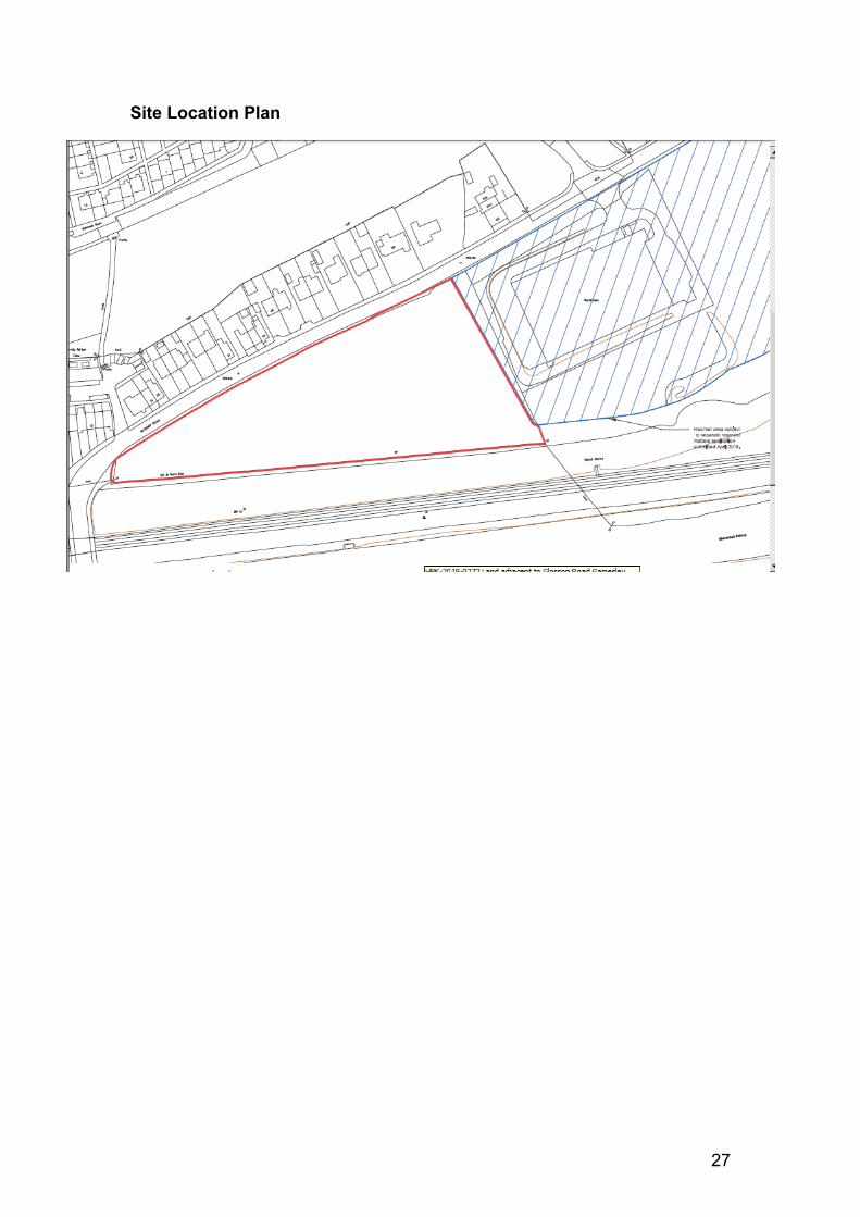
Location Land adjacent to Glossop Road, Gamesley, GlossopProposal 44 Homes and ApartmentsApplicant Pendragon Estate DevelopmentsAgent Patrick Rattigan PWR PlanningParish/ward St John’s Ward Date registered 02/05/2018If you have a question about this report please contact: James Stannard, Tel. 01298 28400 extension 4298, [email protected]
1. SUMMARY OF RECOMMENDATION
APPROVE with Conditions subject to Section 106 Agreement
1. REASON FOR COMMITTEE DETERMINATION
1.1 This application is being brought before Planning Committee due to this application relating to Major Development.
2. DESCRIPTION OF THE SITE AND ITS SURROUNDINGS
2.1 The application site comprises a parcel of Greenfield land measuring approximately 1.2 hectares to the south of Glossop Road, Gamesley. The site is located within the built up area boundary of Glossop and is identified within Policy H2 of the Local Plan as a Housing Allocation (‘Land Adjacent to Gamesley Sidings’).
2.2 The site is bounded by Glossop Road to the north and west, with the Glossop-Manchester railway line sitting to the south. The site shares its eastern boundary with the former Samas Roneo warehouse site (now demolished), which is within the applicants control and benefits from an Outline planning consent for residential development under HPK/2014/0665.
2.3 The adjacent Samas Roneo site is currently subject to a planning application for the approval of all Reserved Matters relating to the outline consent (HPK/2018/0191).
3. DESCRIPTION OF THE PROPOSAL
3.1 This application seeks full planning permission for 44 houses and apartments.

2
3.2 The primary vehicular access to the proposed development is shown on the Site Layout Plan (Drawing Ref: 1011-A-102 Rev C) to be from the neighbouring Samas Roneo site, which is within the applicants control and benefits from an outline consent. A secondary private access is proposed to Glossop Road in the south western part of the site opposite the driveway for No.27 Glossop Road, which serves plots 119-122.
3.3 The proposed scheme comprises a mixture of 2, 3 and 4 bedroom properties of which 30% would be for affordable purposes. The dwellings are predominantly two storey, with selected buildings having accommodation within the roof space (2.5 storey) and 3 storeys (apartment blocks). The housing mix and design of the scheme is discussed in more detail within the assessment section of this report.
3.4 The application is accompanied by the following technical reports and documents:
- Design and Access Statement (as revised)- Proposed House Types Floor Plans and Elevations (as revised)- Illustrative Masterplan (as revised)- Proposed Site Plan (as revised)- Affordable Housing Statement- Affordable Housing Plan (as revised)- Assessment against Part M of the Building Regulations- Housing Mix and Affordable Housing Statement (as revised)- Boundary Treatment Details and Plans (as revised)- Materials Plan (as revised)- Refuse Strategy Plan (as revised)- Tree Schedule- Tree Survey Plan- Sustainability and Building of Life Statement- Street Scenes (as revised)- Secondary Site Access Technical Drawing (SK-003)- Secondary Site Access Visibility Splay (SK-005)- Phase 1 Contaminated Land Assessment- Transport Assessment- Travel Plan- Flood Risk Assessment- Ecological Impact Assessment- Archaeological Evaluation Report (as revised)- Air Quality Assessment
4. RELEVANT PLANNING HISTORY
4.1 There is no previous planning history on the site; however there are relevant planning applications on adjacent land which are listed below:
3
HPK/2014/0665 Outline planning permission for proposed demolition of warehouse and residential development of land and associated works (Approved 13th April 2015)
HPK/2018/0178 Proposed Variation of Conditions 4 and 9 relating to HPK/2014/0665 for revised Site Layout including new vehicular access – Resolution to approve, subject to S106 Deed of Variation
HPK/2018/0191 Approval of Reserved Matters relating to HPK/2014/0665 - Pending
5. PLANNING POLICIES RELEVANT TO THE DECISION
High Peak local Plan 2016
S1 Sustainable Development PrinciplesS1a Presumption in favour of Sustainable DevelopmentS2 Settlement HierarchyS3 Strategic Housing DevelopmentS5 Glossopdale Sub-Area StrategyEQ5 BiodiversityEQ6 Design and Place MakingEQ7 Historic EnvironmentEQ9 Trees Woodland and HedgerowH1 Location of Housing DevelopmentH2 Housing AllocationsH3 New Housing DevelopmentH4 Affordable HousingCF3 Local Infrastructure ProvisionCF6 Accessibility and TransportCF7 Planning Obligations and Community Infrastructure Levy
National Planning Policy Framework
Achieving Sustainable Development Chapter 2Delivering a Sufficient Supply of Homes Chapter 5Promoting Sustainable Transport Chapter 9Achieving Well Designed Places Chapter 12Conserving and enhancing the natural environment Chapter 15Conserving and enhancing the historic environment Chapter 16
6. CONSULTATIONS CARRIED OUT
Site notice Expiry date for comments: 24th July 2018Neighbour letters Expiry date for comments: 12th July 2018Press Notice Expiry date for comments: 19th July 2018

4
Neighbours
6.1 A total of 13 representations have been received which object to the application. The objections are summarised below:
Concerns regarding the safety of the entrance nearest to the railway bridge serving Plots 119-122
Upgrades to transport infrastructure required prior to residential development
Increase in traffic volume will impact negatively on highway safety Impacts to wildlife Lack of parking provision Suitability of existing utilities to support development
6.2 1 letter supporting the application has also been received.
Consultees
HPBC Economic Development
National research has identified that 34% of household expenditure is spent at district level or below. This development is calculated at £404,907 per annum.
Each new house will generate jobs within the construction industry or associated supply chain. The development is calculated to generate 47 direct jobs and 6 indirect jobs.
The development will generate approximately £8,623 council tax for the area per annum
HPBC Operational Services (Open Space)
There aren’t any major concerns with the design and layout of the on-site open space but with regard to the area on application 2018/0272, in the western corner of the site, I think that part of it is proposed as a wildflower area. I would suggest that the wildflower planting is removed, and the whole area is created as amenity grass. There are significant ongoing maintenance issues with wildflower areas which mean they can often be left looking an untidy weedy mess. With this open space being in a prominent position and visible from the roadside, this could look very unsightly. I would suggest that the whole area is created as amenity open space, but would also suggest that groups of trees are planted to prevent it becoming an informal kick about area.
For the Full application (HPK/2018/0272) we would be also be requesting the following:-
- Off site play contribution to be used to enhance existing play facilities within Gamesley - £192 x number of dwellings (£8,448)
- Off site outdoor sports contribution to enhance existing
5
outdoor sports facilities within Gamesley – £489.40 x number of dwellings (£21,533.60)
- Off site allotment contribution to the existing allotment site on Melandra Castle Road - £76.95 x number of dwellings (£3,385.8)
HPBC Waste & Recycling
No concerns on application
DCC Policy & Monitoring – Initial Comments
Further Comments
Requires £174,865.29 towards the provision of 5 x secondary and 2 x post 16 places at Glossopdale School based on standard formula.
Local Councillor Becki Woods has provided further comment below
“If there is going to be more houses in Gamesley then as part of the project they must consider opening a railway station in the area, as it stands public transport is non-existent. There are buses on week days, but none in the evenings or weekends. A rail station would provide the opportunity for economic growth in the area, as people would be able to go further afield to access jobs they currently can’t without a car, which in turn would increase the desirability of the area. The new builds also means more people and more cars on the roads. If trains were accessible it would also benefit the environment, as it would take some of these cars off the road. A rail station in Gamesley would also benefit the nearby communities of Charlesworth and Simmondley as both of these areas suffer similar problems of lack of transport.”
DCC Archaeologist Initial Comments
Archaeological potential on site is two fold. Potential for early prehistoric activity and Melandra to Buxton Roman road and associated features.
Current proposals do not include any archaeological information and is therefore deficient in terms of NPPF para 128. Because the route of the Melandra to Gamesley Roman road is likely to pass within the site boundary, I would expect this to be tested by archaeological field evaluation in advance of determination. In the absence of any such information I therefore object to this application in its current form because of insufficient information in relation to the significance of heritage assets.
This objection could be addressed by submission of the results of archaeological field evaluation on the site, to a specification agreed with the LPA.

6
Revised Comments
Further Revised Comments
I advise that there a couple of issues to be addressed before the local planning authority accept the report and before we make recommendations accordingly. These relate to the archaeology in Trench 7, which is the critical area of site as a possible alignment of the Buxton-Melandra Roman Road.
When I visited the site I saw the feature they interpret as a post-medieval field boundary in text, but also advised that a second (parallel) possible feature be investigated, in case these formed a continuation of a trackway which is visible on 19th century mapping (at least to the north of Glossop Road where it has been interpreted as a possible course for the Roman road approaching Melandra). I also advised the contractor to take samples from the relevant features for processing (in the absence of dating evidence) and to provide some discussion of the relevant historic mapping to check whether the features I can’t see in text any discussion of this second possible feature or the results of this investigation/sampling etc.
These issues should be addressed in text to clarify the results of the evaluation, and the mapping at Fig 1 needs to be superimposed on a more detailed OS base (e.g. Mastermap) as the current background used doesn’t allow us to locate the features with any certainty. The report could then be re-submitted as additional information.
This partially addresses my previous comments to the extent that I am able to make further recommendations on the site. These relate to the current application HPK/2018/0272 but also to the archaeological Condition 18 placed on HPK/2014/0665 for the site immediately to the east.
The evaluation trenching did not identify significant archaeological remains over the bulk of the site. The results in the area of Trench 7 remain however somewhat equivocal; this is a critical part of the site and one suggested alignment of the Melandra to Buxton Roman road brings it across this trench, along the line of the former field boundary shown on 19th century mapping and a trackway further north passing east of 61 Glossop Road, an alignment also continuing south of the railway at Gamesley Farm.
Trench 7 identified a linear feature apparently on the line of the former field boundary, but no other features on the same alignment, although there was slight parallel depression 5m to the east which the excavators were unable to interpret within the narrow trench as a clear archaeological feature. Although

7
the linear is likely to be the field boundary shown on historic mapping, it remains undated, and we are unable to assess at present the origins of this feature, particularly when this line of field boundaries across the landscape has been interpreted as fossilising the line of the Roman road and may prove to have been very long-lived.
This key research question for the site could be addressed through a relatively small area of strip-and-record excavation centred upon the linear feature identified in Trench 7. This would allow the proper analysis and dating of the relevant feature and better identification of any associated archaeology. The relevant area lies on the dividing line between the two applications, so would require a condition being placed on HPK/2018/0272 for archaeological work, and a continuation of Condition 18 on HPK/2014/0665.
The following conditions should therefore be attached to any planning consent for the current application, and Condition 18 on the existing application should not be discharged until the further excavation has taken place to an agreed WSI:
"a) No development shall take place until a Written Scheme of Investigation for archaeological work has been submitted to and approved by the local planning authority in writing, and until any pre-start element of the approved scheme has been completed to the written satisfaction of the local planning authority. The scheme shall include an assessment of significance and research questions; and 1. The programme and methodology of site investigation and recording2. The programme for post investigation assessment3. Provision to be made for analysis of the site investigation and recording4. Provision to be made for publication and dissemination of the analysis and records of the site investigation5. Provision to be made for archive deposition of the analysis and records of the site investigation6. Nomination of a competent person or persons/organization to undertake the works set out within the Written Scheme of Investigation" "b) No development shall take place other than in accordance with the archaeological Written Scheme of Investigation approved under condition (a)."
"c) The development shall not be occupied until the site investigation and post investigation assessment has been completed in accordance with the programme set out in the
8
archaeological Written Scheme of Investigation approved under condition (a) and the provision to be made for analysis, publication and dissemination of results and archive deposition has been secured."
United Utilities No objection subject to conditions relating to Foul Water and Surface Water
Derbyshire Wildlife Trust
Report produced by SLR has been submitted with the dual purpose of discharging conditions relating to the neighbouring Outline scheme (HPK/2014/0665) and this full application.
Sufficient information has been provided to determine the application. The Trust welcomes the scheme design, which retains existing hedgerows outwith garden curtilages and buffers the hedgerows and offsite railway embankment woodland with open space.
No objection subject to appropriate conditions. HPBC Arboricultural Officer
Tree information provided is not entirely clear which trees are to be retained. In any event any tree loss to accommodate this proposal is not significant. However the landscaping and amenity spaces of the proposed development are important.
The landscaping plans provided are indicative only and therefore a condition requiring a detailed landscaping plan is required.
The trees species proposed do not offer enough diversity, only 2 species, and I am concerned that the Oak species selected may not thrive in this area.
We will also require details of how the areas of amenity space will be managed. Again this can be dealt with by condition.
No objections subject to appropriate conditions
DCC Highways Access to the application site is derived through the adjoining development site, which currently benefits from outline consent and is subject to a reserved matters application (HPK/2018/0191). At present the Highway Authority has not fully endorsed revised access proposals – amendments to the design of the junction are currently being considered by the applicant.
Access to service this site will therefore be entirely dependent on the outcome of the approval of the application on the adjacent site and I presume your Authority is, in principle, satisfied with this arrangement.
9
Current development proposals include a new access point to public highway serving plots 119-122. This access is located relatively close to a bend in the highway alignment and whilst the transport assessment quotes that the access is appropriate for the number of dwellings it serves, there are no supporting designs or information to substantiate this (i.e. speed surveys, visibility sightlines, impact on, or access to, adjoining bus stop etc.).
Given the geometry of the highway margins at this location, it is likely a considerable section of roadside verge may need to be removed to achieve acceptable visibility sight lines. Whilst it is appreciated this may be feasible to achieve, given the roadside frontage available, nevertheless this should be appropriately shown on the application drawings. A specific access plan and supporting information should therefore be provided to demonstrate that an ‘appropriate’ means of access, meeting current safe minimum criteria, can be achieved at this location, having regard to existing highway arrangements.
Internal street layout is generally acceptable, although I would suggest further consideration be given to the following layout issues, in the interests of highway safety and in order to meet current highway residential design guide criteria:
It is assumed that the priority street will be from east to west and then northwards to the turning area, adjacent plot 126; the street serving plots 112 – 118 forming a side road spur off this street. On this basis the bend fronting plots 130/131 should be laid out with appropriate geometry (including any widening on the inside of the bend) and a 25m forward visibility splay; the area in advance of the splay forming part of the street and not part of any adjoining plot. This is likely to engender a minor amendment to the plot boundaries associated with plots 130/131 to achieve. The road serving plots 112–118 could then form a private side road cul-de-sac.
An internal pedestrian route is shown on the plans, towards the northern part of the site, in favour of a roadside facility directly adjacent the A626. Whilst this is acceptable in principle, and provides a usable link between the residential properties and primary site access and bus stops etc, this is shown linking into proposed private drive areas - on the adjacent development site a separate pedestrian route is available alongside the private drives. It would be useful if the applicant could clarify how these private areas and paths would be managed / maintained in the future to insure they remain available for pedestrians.
It is again noted that there are some inconsistencies between
10
application drawings, this is particularly noticeable on the Master Plan / General Arrangement drawings and the Proposed Site Plan. The Proposed Site Plan does not show a pedestrian link between the private drive serving plot 119-122 and the bus stop further west, however, the Master Plan and General Arrangement drawings show a path through the public open space area, linking to the bus stop to the west of the site. For the avoidance of doubt the Highway Authority considers the link is a necessary feature and therefore application drawings should be updated to reflect this.
The proposals should also consider how pedestrians will cross the A626 at the western part of the site to access the bus stop on the opposite side of the road (to the development) and also the Trans Pennine Trail route.
Vehicle swept path analysis should be provided to ensure service / delivery vehicles can successfully traverse the new estate streets and manoeuvre within the turning areas provided. The largest vehicle likely to access the streets on a regular basis is likely to be a refuge vehicle – the Manual for Streets document suggests swept path analysis being undertaken for a large refuse vehicle (11.6m long); this information should be available for all bends and turning areas within the site.
The Highway Authority recently released new design guidance criteria for adoptable estate street designs – Delivering Streets and Places document. This guidance recommends a minimum carriageway dimension of 5m wide for adoption purposes, to take account of larger refuge vehicles, service and delivery vehicles and potentially on street parking from residents / visitors vehicles. Ideally street dimensions should be adjusted to achieve this.
The parking associated with plots 117 and 118 is considered to be restricted, with limited opportunity for vehicles to adequately turn close to the properties - this could result in overlong reversing manoeuvres to or from the parking spaces. The General Arrangement drawings identify vehicle turning circles on the plans, however, the dimension of the facility serving these plots appears to be very limited for vehicle manoeuvring. The applicant should consider enlarging the turning area or alternative arrangements to allow vehicle turning to take place.
It is unlikely refuse vehicles will enter private driveway areas for the collection of bins. The applicant should therefore consider convenient areas, off the main street, for the storage of bins on bin collection days, to avoid pedestrian footways being obstructed. It is noted that permanent bin storage areas
11
Revised Highways Comments
are indicated within the plot curtilage, however, separate consideration needs to be given to what happens for roadside collections; for individual properties it is likely associated driveways could be used for bin storage purposes, however, shared private drives may require dedicated facilities to be provided.
It is noted that the roadside boundary alongside the A626 indicates a number of trees being planted. It is suggested, in line with the requirements of the Highways Act 1980, that any tree planting be set back into the site at least 4.6m (15 feet) from the centreline of any adopted carriageway, to ensure the root system does not affect the integrity of the public highway and that any maturing tree does not overhang carriageway areas.
I would be grateful if the applicant could consider the above comments with a view to providing additional supporting information and revised drawings to address the issues raised. Upon receipt of this information I will provide further highway comments. Should you wish to discuss the above comments further please do not hesitate to contact me.
A revised site boundary treatment plan has been submitted – Drg No 1101-A-122 Rev A – this shows a completely different ‘red / blue’ application site boundary to the other 2 planning applications relating to this site (and referred to above). The ‘blue’ adjoining land controlled by the applicant appears to include an additional triangular section of land, to accommodate the construction of the revised access.
The boundary also appears to be in a different position in relation to the proposed access road (there appears to be a larger margin on the western side of the road compared to other plans).
The triangular piece of land therefore doesn’t form part of any ‘red’ outline in any of the applications associated with this or the adjoining site. I would therefore question whether this is acceptable to your Authority, particularly in light of my comments above.
In terms of the internal estate street layout the applicant has demonstrated that the layout is acceptable in terms of forward visibility, however, again there are issues relating to the turning manoeuvre for the refuse vehicle. Again, the manoeuvre relies on entering private drive areas to complete the manoeuvre, however, in the case of the turning area opposite plot 114 the street proposed is clearly not sufficient for the vehicle to turn
12
within the proposed surfaced limits.
This could be resolved by extending the street and providing the applicant is willing to amend this as part of any construction approval process, if they are intending to pursue adoption of the street, it is likely this could be covered by condition.
The secondary access to Glossop Road, serving plots 119-122, has been demonstrated that it can be provided with an acceptable level of visibility, however, this will rely on a significant section of roadside hedge to be removed, to achieve. Drawing no SK-003 identifies the sightlines achievable and makes reference to the master-plan drawing which identifies the hedge removal (however, it is not entirely clear on this plan). However, on the basis that the hedgerow will be removed to achieve an acceptable level of visibility as identified on the drawing the Highway Authority would not be in a position to object to the proposals.
A Travel Plan has been included as part of the application submission, this considers the whole site, covered by application references HPK/2018/0191 and HPK/2018/0272. A number of comments have been made with respect to the TP, which are currently by the applicant.
Derbyshire County Council is now able to offer an online toolkit known as STARSFor, https://starsfor.org/ for the purposes of Travel Plan monitoring. This is available for a fee payable to Derbyshire County Council, and enables the user to input monitoring data and track modal shift. This replaces any other travel plan monitoring fee that may be charged. Should this be of interest, please contact the Derbyshire County Council Sustainable Travel Team: [email protected] . Alternatively the Highway Authority would wish to include secure funding in a section 106 Agreement for the monitoring of the Travel Plan over the initial 5 year period. The funding required for this would be £500 per year for 5 years (£2500 total).
Whilst the applicant has addressed the majority of highway issues previously raised there are still some elements that remain. However, these are relatively minor in nature and would not be sufficient to refuse the application on highway safety grounds alone (however, it may be sufficient to prejudice adoption if the turning arrangements cannot be addressed).
In addition there is, as highlighted above, a potential issue regarding the application site boundaries with this and the adjoining application site. Providing this can be resolved to the
13
Environment Agency
Environmental Health Officer
Flood Risk Management Team
satisfaction of your Authority and the proposals are otherwise acceptable in planning terms it is unlikely the highway authority would be in a position to raise a sustainable objection in principle to the application proposals. No objections subject to appropriate conditions.
No comment as there are no environmental constraints associated with the site which fall within the remit of the Environment Agency
No comments to make
The land within the application boundary is greenfield and as such should discharge surface water at the greenfield rate as per DEFRA’s Non-Statutory technical standards for sustainable drainage
7. POLICY AND PLANNING BALANCE
Planning Policies
7.1 The determination of a planning application is to be made pursuant to section 38(6) of the Planning and Compulsory Purchase Act 2004, which is to be read in conjunction with section 70(2) of the Town and Country Planning Act 1990.
7.2 Section 38(6) requires the local planning authority to determine planning applications in accordance with the development plan, unless there are material circumstances which 'indicate otherwise'. Section 70(2) provides that in determining applications the local planning authority "shall have regard to the provisions of the Development Plan, so far as material to the application and to any other material considerations." The Development Plan consists of the High Peak Local Plan Policies Adopted April 2016.
7.3 Other material considerations include, adopted Supplementary Planning Guidance, the National Planning Policy Framework (NPPF) and National Planning Policy Guidance (NPPG). Paragraph 11 of the NPPF explains that at the heart of the Framework is the presumption in favour of sustainable development. For decision makers this means that when considering development proposals which accord with the development plan, they should be approved without delay, but where the development plan is absent, silent or relevant policies are out of date, grant planning permission unless the application of policy in the
14
NPPF provide clear reason for refusal or any adverse impacts would significantly and demonstrably outweigh the benefits when assessed against the policies in the NPPF taken as a whole.
7.4 Local Plan policy S1a establishes a presumption in favour of sustainable development as contained within the NPPF.
Principle of Development
7.5 The site is situated within the built up area boundary of Glossop as defined on the adopted Proposals Map which is defined as a Market Town within the settlement hierarchy contained within Policy S2 of the Local Plan; market towns being the focus for all new development.
7.6 The site is a housing allocation as set out within Policy H2 of the Local Plan (‘Land adjacent to Gamesley Sidings’ G26) for approximately 38 dwellings, and is not constrained by any sensitive statutory designation.
7.7 In light of the above, the principle of development is considered to be acceptable subject to all relevant planning material considerations.
Housing Mix
7.8 Policy H3 of the adopted Local Plan requires all new residential development to address the housing needs of local people by providing a range of market and affordable housing types and sizes that can reasonably meet the requirements and future needs of a wide range of household types based on evidence from the Strategic Housing Market Assessment. New residential development should also provide a mix of housing that contributes positively to the promotion of a sustainable and inclusive community taking into account the characteristics of the existing housing stock in the surrounding locality.
7.9 The original proposed housing mix was not considered to be acceptable by the local authority. The revised proposed mix is set out below, showing a comparison with the requirements of the SHMA
Revised Proposed Mix Percentage SHMA requirement
3 x 1 bedroom 7% 10%
14 x 2 bedroom 32% 45%
18 x 3 bedroom 41% 35%
9 x 4 bedroom 20% 10%
7.10 The Statement submitted by the applicant includes evidence to support the justification for this housing mix and departure from Policy H3. It highlights that based on data from the 2011 census; Gamesley had the lowest level of owner occupation in the Borough at 30.6%, the highest

15
social rented sector by ward (63%), and the second lowest private rented sector (4.3%). It is argued by the applicant that this application would bring a new choice to local people who may wish to aspire to own or occupy new 1, 2, and particularly 3 and 4 bed dwellings in the area.
7.11 The applicant also argues that ‘soft market testing’ (discussions/emails from four estate agents in Glossop) in August 2018 has revealed that demand is high for 4 x bedroom properties provided they are appropriately priced, and that there are a lack of 4 x bedroom properties in the Gamesley area. The Statement notes that as of 10th August 2018, according to Zoopla (an online estate agent) there are 24 four bedroom properties for sale, 18 of which (75%) are priced at £400,000 or above.
7.12 The Statement submitted by the applicant stresses that the overall housing mix should be viewed in conjunction with the neighbouring Samas Roneo site which comprises a development of 93 dwellings. The housing mix relating to bedroom size for Phase 1 (Samas Roneo site with Outline consent) and Phase 2 (this neighbouring application site) are shown in the table below with comparison to the SHMA requirements.
Phase 1 (93) Phase 2 (44) Total (137) SHMA 1 bed 7% 7% 7% 10%
2 bed 28% 32% 29% 45%
3 bed 48% 41% 46% 35%
4 bed 17% 20% 18% 10%
Total 100% 100% 100% 100%
7.13 In response to the applicants Housing Types and Housing Mix Statement, it is considered that the notion of current residents of Gamesley living in social rented housing, many of whom are on low incomes, suddenly ‘aspiring’ or having the ability to move into a 4 x bedroom property priced at the current market value of between £300,000 - £400,000 is considered to be highly unrealistic and unlikely.
7.14 However, the revised housing mix does represent a positive change comparable to the mix originally proposed, with a moderate increase in the number of 2 and 3 bedroom properties at the expense of 4 bedroom properties.
7.15 The neighbouring site for 93 dwellings is currently subject to a Reserved Matters application. Legal advice has confirmed that the issue of housing type and mix cannot be re-opened at the Reserved
16
Matters stage, and therefore it is reasonable to expect that the mix set out within the table above will be realised (subject to all other considerations).
7.16 As such, when assessing the revised proposed housing mix for this full application as part of the wider housing development, it is clear that the majority of the overall site (46%) would be taken up by 3 bedroom properties with only a marginal difference (+8%) in the number of 4 bedroom properties, comparable to requirements within the SHMA.
7.17 With regards to housing mix in terms of type, the revised Site Layout Plan highlights that the scheme will comprise a mix of semi-detached and detached properties, but does not include any provision for elderly/bungalow provision, contrary to the identified need of 20% within the SHMA.
7.18 Section 5.0 of the revised Housing Mix and Types Statement highlights that discussions which have taken place between the applicant and Regeneration Officers prior to the application being submitted revealed that there is a current surplus of bungalows within the Gamesley estate. It is stated that advice was given by Regeneration Officers that there was little demand for bungalows and that this advice influenced the design of the scheme in accommodating one and two bedroom apartments.
7.19 In addition, it has been stated that the proposed house types comply with the accessibility standards set out in the Optional Requirements M4(2) of Part M of the Building Regulations. An assessment was received by email dated 6th September which has fully demonstrated compliance with these regulations.
Affordable Housing
7.20 Policy H4 of the adopted Local Plan requires new development schemes secures 30% affordable housing provision on sites proposing 25 units or more, and should seek to achieve a target of 80% rented accommodation with the balance being provided as intermediate housing. For this site a 30% provision of affordable housing equates to 13 units.
7.21 The scheme will provide 8 x 2 bedroom properties (House Type A), and 5 x 3no. bedroom properties (3no. House Type B and 2no. House Type C). The affordable units will comprise 80% rented accommodation with 20% being provided as intermediate housing, which would meet the terms of Policy H4.
7.22 The layout shows the location of the affordable housing which would be located in 3 small clusters around the site. The tenures and layout of the affordable housing provision is considered to be acceptable.
17
7.23 The affordable housing would need to be secured in a Section 106 Agreement. Overall the application is considered to accord with Policy H4 of the Local Plan.
Design Matters (Layout, Scale, Landscaping, Appearance)
7.24 Policy EQ6 of the adopted local plan states that all development should be well designed to respect and contribute positively to the character, identity and context of High Peak’s townscapes, in terms of scale, height, density, and layout.
7.25 The High Peak Residential Design Guide SPD (2005) and more recently adopted Design Guide SPD (2018). The 2005 SPD provides useful guidance for designing new housing developments.
7.26 The Residential Design Guide (2005) requires that good layout design is that the pattern of housing should inform the road layout and not vice versa, with streets not being designed for the sole use of traffic. Dwellings should be positioned to create a sense of enclosure with frontages facing the street and private backs located together.
7.27 Paragraph 127 of the NPPF states, amongst other matters, that new developments should function well and add to the overall quality of the area, not just for the short term but over the lifetime of development; are visually attractive as a result of good architecture, layout and appropriate and effective landscaping; and are sympathetic to local character and history, including the surrounding built environment and landscape setting.
Layout
7.28 Glossop Road is characterised by primarily two storey terraced semi detached properties to the north of the highway which front the site.
7.29 This housing development is characterised by three broad areas of housing, with a primary access coming from the neighbouring housing site forming a ‘Y’ shape. The single apartment block is positioned centrally near to the southern boundary of the site. Properties to the north front onto Glossop Road in a linear fashion which responds positively and in keeping with the existing street scene.
7.30 The revised internal layout of the scheme has been amended to address concerns raised by Officers relating to the car dominated frontage of some properties by introducing intermittent areas of green space and revising the layout of house types.
7.31 HPBC Operational Services have commented on the proposed area of open space in the western part of the site. It has been suggested that the wildflower planting is removed and that the whole area is created as amenity grass, which incorporates tree planting. It is considered that
18
this small detail can be dealt with as part of the landscaping conditions requested by the Arboricultural Officer. Overall it is considered that the layout of the site would respond well to the general character of the area, thus complying with Policy EQ6 of the Local Plan.
Scale
7.32 The proposed house types are consistent with the proposed house types put forward within the reserved matters application on the adjacent site (HPK/2018/0191).
7.33 The proposed development contains 13 x house types which are predominately a mixture of 2 and 2.5 storey properties with a single 3 x storey block of apartments. The table below shows how the proposed house types compare with the nationally described space standards (NDSS) published by DCLG. Compliance with these standards is an important aspect of the design and layout of the site, ensuring that future occupants have an acceptable amount of living space. The table shows that all house types exceed the minimum standards, with the exception of two house types (House Type A by 2sqm, and House Type L by 11sqm). Whilst both of these house types are slightly below the standard, the overall majority will meet the prescribed standards.
House Type People Bedrooms Storeys Floor Space DCLG StandardsA 4 2 3 77 79B 4 2 2 98 79C 4 2 2 107 93D 5 3 2 102 93E 6 3 2 111 102F 6 3 3 117 108H 5 3 2 102 93I 7 4 2 143 115J 7 4 2 127 115K 7 4 2 147 115L 7 4 2 104 115
7.34 House Types A-L typically has a height to eaves level of approximately 5.0m, reaching an overall ridge height of approximately 8.9m. The two three storey apartment blocks are shown to have an eaves height of 7.7m and reach an overall height of 11.5m.
7.35 It is considered that these house types are of an appropriate scale for this urban-rural fringe location; providing the right amount of space for future occupants whilst respecting the scale and height of neighbouring development, and the sensitive border with the open countryside, in accordance with policies S1 and EQ6 of the Local Plan.
Appearance
7.36 Section 5 of the Residential Design Guide SPD (2005) makes reference to four broad character types of housing. The SPD notes that these distinct styles should not be copied, but rather be used as a
19
useful starting point for which contemporary housing can respond to the relevant townscapes. The Landscape Character SPD (2006) also includes useful guidance on aspects of Building Form and Detail.
7.37 The site is situated within the Settled Valley Pastures Landscape Character Area (LCA) as defined within the Landscape Character SPD. A review of the proposed house types shows that they have responded to, and been influenced by, the key character house types set out in section 5 of the Residential Design Guide SPD, and been designed in such a way that draws inspiration from and responds well to the local vernacular. Overall the proposed housing incorporates some of the defining architectural features of the High Peak.
7.38 House Types A and B show a similarity and relationship with the semi detached ‘Small Scale Villas’ type. These dwellings give the appearance of a larger detached home by being proportionate and symmetrical, having a simple rectangular form. The larger house types such as J and K, share some of the characteristics of the ‘Grand Villas’ house character type, with a symmetrical frontage, dual pitched roofs, and the presence of small pitched dormer roofs in the roof space.
7.39 The submitted plans show the external walls to be either natural or reconstituted stone, with roofs being finished in a natural or reconstituted slate. First floor windows are shown to sit tight to the eaves level, and bordered by stone headers and sills in line with adopted guidance. Some properties incorporate stone quoins into the corners. A condition will be imposed to appropriate materials.
7.40 With regards to apartment blocks, it is noted within the Residential Design Guide SPD, three storey buildings are not part of the intrinsic historical character of the High Peak. It is acknowledged that due to their naturally higher scale, and relatively uniform character, achieving a design which blends in with existing character can be difficult. Revised elevations have been submitted which have improved the fenestration at the front of the building. It is clear that the design and appearance of the apartment blocks represent a continuation and consistency with other house types and are considered to be acceptable.
7.41 Street Scenes have been submitted which show that the level changes throughout the site are fairly subtle. A condition is recommended which requires finished floor level information prior to commencement of development.
7.42 It is considered that the applicant has responded positively to the relevant design guidance and developed a scheme which references and highlights traditional architectural style, features and materials, resulting in a scheme which relates well to the existing character and appearance of Glossop Road and the wider area. Accordingly it is considered that the proposed development would be accordance with
20
policies S1 and EQ6 of the Local Plan, relevant supplementary planning guidance and paragraph 127 of the NPPF.
Residential Amenity
7.43 Policy EQ6 of the Local Plan requires all new development to have a satisfactory relationship with existing land and buildings and protects the amenity of the area, which includes residential amenity of neighbouring properties. Aspects of residential amenity include impacts such as a loss of sunlight, overshadowing and overbearing impacts, loss of outlook, and loss of privacy.
7.44 Paragraph 127 of the NPPF states that planning should create places with a high standard of amenity for existing and future users.
7.45 The High Peak Residential Design Guide SPD (2005) provides further guidance with regards to amenity and privacy in new developments. A distance of 21 metres between habitable room windows of adjacent properties should be provided to ensure an acceptable level of privacy. The SPD states that where buildings are located closer than 21 metres, the position of windows and doors should avoid creating direct views from properties. Windows which are more sensitive to overlooking, such as bedrooms and bathroom should be located towards the rear of the property. Window sizes should reflect the level of privacy within the room.
7.46 The proposed revised layout shows that a number of properties will be achieve an isolation distance of 21m, where this has not been possible, the minimum distance between habitable windows is approximately 17 metres. Whilst it is acknowledged that this distances falls short of the recommended distance of 21 metres, no property directly faces another, each being at a slight angle, thereby reducing the impact of overlooking and privacy.
7.47 The proposed floor and elevation plans demonstrate that sensitive windows such as bathrooms are smaller in scale. A suitably worded condition will ensure that these are obscure glazed and that the amenity of future occupiers is protected.
7.48 The revised layout plan also shows that the area of garden space associated with each property is varied. There are no prescribed minimum standards for gardens within the Residential Design Guide SPD and therefore each development is to be judged on its own merits.
7.49 It is considered that whilst it would be desirable for certain properties to have more amenity garden space associated with it, this has to be balanced against the need to maximise the number of homes which can be delivered within the site, taking into account all other design considerations.

21
7.50 Appropriate conditions will ensure that boundary treatments are strictly controlled to both preserve the privacy and amenity of each property. Subject to the developer complying with these conditions, it is considered that the proposed development will not result in any significant adverse harm to residential amenity in line with Policy EQ6 of the Local Plan, the High Peak Residential Design Guide SPD, and paragraph 127 of the revised NPPF.
Archaeological Assets
7.51 Policy EQ7 of the Local Plan requires that all new development conserves or enhances statutory and non statutory heritage assets, which includes any potential archaeological sites, in line with relevant policies contained within Chapter 16 of the NPPF.
7.52 Comments received from DCC Archaeological Officer highlight the archaeological potential on site relating to early pre-historic activity and the Melandra to Buxton Roman Road, and that appropriate investigations should be carried out prior to the determination of the application.
7.53 The applicant has submitted a Field Evaluation Report. It was noted that further information and clarification was required within a resubmitted report, to be approved, prior to the local authority being in a position to fully assess and determine the application.
7.54 The DCC Archaeological Officer has provided updated comments following the submission of the revised Field Evaluation. Whilst a key research question regarding potential assets remains outstanding, it has been stated that this can be dealt with by way of an appropriately worded condition. As such, it is considered that the proposal would not result in any harm to any archaeological assets, in line with policy EQ7 of the Local Plan and relevant policies within Chapter 16 of the NPPF.
Ecology and Trees
7.55 Policy EQ5 of the Local Plan requires all new development to conserve protected ecological assets and species, and where possible to contribute a net gain for biodiversity.
7.56 Policy EQ9 of the Local Plan states that the Council will protect existing trees, woodland and hedgerows, requiring development where possible to provide appropriate tree planting and soft landscaping.
7.57 Chapter 15 of the NPPF contains the relevant national planning policy guidance for the conservation and enhancement of the natural environment.
7.58 The application is supported by an Ecological Impact Assessment. This assessment has been reviewed by the Derbyshire Wildlife Trust who

22
has confirmed that as the proposed scheme supports biodiversity enhancements, there is no objection to the application and that such enhancements should be secured via appropriately worded conditions.
7.59 The application is accompanied by a Tree Survey. As noted by the Tree Officer, any tree loss as a result of this proposal would not be significant, and therefore there are no objections subject to appropriate landscaping conditions.
7.60 It has been highlighted that a small section of existing hedgerow of low ecological value will have to be removed in order to accommodate the secondary access to Glossop Road and associated visibility splay. It is not considered that the removal of this hedgerow constitutes significant adverse harm to ecological assets.
7.61 In light of the above, it is considered that subject to appropriate conditions, the application would result in biodiversity enhancement, would not result in the loss of any protected or veteran trees, and therefore is compliant with policies EQ5 and EQ9 of the Local Plan and relevant policies contained in Chapter 15 of the NPPF.
Flood Risk and Drainage
7.62 Policy EQ11 of the Local Plan relates to Flood Risk Management and supports development proposals that would not result in an increase in flood risk on site or elsewhere.
7.63 The site located within any Flood Zone 1, an area which is at the lowest risk of flooding.
7.64 The Environment Agency has stated that they have no comment to make on the application. The Lead Local Flooding Authority has no objections, noting that the discharge of water should comply with DEFRA’s non-statutory technical standards.
7.65 As such, the application, subject to appropriate drainage conditions, is not considered to result in any adverse harm to flood risk, either on site or elsewhere in the Borough, in line with policy EQ11 of the Local Plan.
Access and Highway Safety
7.66 Policy CF6 of the adopted local plan seeks to ensure that development can be safely accessed in a sustainable manner and that all new development is located where it can satisfactorily accommodated within the existing highway network.
7.67 Paragraphs 108 and 109 of the NPPF require all new development to incorporate safe and suitable access for all users and that development should only be prevented or refused on highway grounds if there would
23
be an unacceptable impact on highway safety, or the residual cumulative impacts on the road network would be severe.
7.68 The Highway Authority raised objections to the original plans on a number of key issues as set out within the initial consultation response.
7.69 Revised and updated plans have been submitted which include detailed swept path analysis and the provision of visibility splay to the secondary access and minor changes to the internal layout.
7.70 The updated and revised Highways Authority comments demonstrate that the majority of the issues have been satisfactorily addressed, with minor outstanding issues relating to manoeuvrability for refuse vehicles. Revise and updated plans have been received which has sought to address this issue. It has been stated by the Highways Authority that any outstanding minor issues can be resolved as part of the separate consent required for works to the highway.
7.71 A revised layout has been submitted which addresses an area of particular concern regarding the turning area relating to Plots 116-118. The highway authority is currently reviewing the revised plans and any further comments will be provided on the updates sheet. Notwithstanding this, it is considered that there would be no adverse impacts on highway safety which would warrant a reason for refusing this application.
7.72 With regards to the inconsistencies of plans and difference between
site boundaries, the applicant has confirmed that the plan viewed by the Highways Authority was an older version of the red line boundary and that the widening of the access required for the main access to the adjoining site is within the red line of this application.
7.73 The applicant has agreed that travel plan monitoring of £500 for a period of 5 years, totalling £2,500 is to be secured within the Section 106 Agreement.
7.74 Objections relating to the wider cumulative impacts of the development on the highway network, lack of existing infrastructure; the impacts on highway safety of the secondary access on to Glossop Road; and insufficient parking provision have been received from members of the public.
7.75 The principle of development has been established through the allocation of this site under Policy H2 of the Local Plan, adopted in 2016. A Travel Plan has been submitted and accepted by the Highways Authority. Whilst it is acknowledged that the scheme will lead to an increase in traffic volume on to the local highway network, this would not amount to severe adverse harm, in the context of paragraphs 108 and 109 of the NPPF.

24
7.76 The objections have been received in relation to the secondary access on to Glossop Road in the north western corner of the site. Following the receipt of revised plans, the Highways Authority has accepted that whilst minor issues relating to the internal layout remain, there are no objections to the proposal in its final revised form.
7.77 Subject to appropriate conditions, and outstanding minor issues to be addressed, it is considered that the proposed development will not result in any significant adverse harm to highway safety or unacceptable cumulative impacts on the wider road network and are therefore in accordance with Policy CF6 of the Local Plan and paragraphs 108 and 109 of the NPPF.
Planning Obligations (Section 106 Agreement)
7.78 Policy CF7 of the Local Plan states that development proposals will be required to provide, or meet the reasonable costs of providing the on-site and off-site infrastructure, facilities and/or mitigation necessary to make a development acceptable in planning terms.
7.79 DCC Policy and Monitoring Team have confirmed that a contribution of £174,865.29 towards the provision of 5 x secondary and 2 x post 16 places at Glossopdale School.
7.80 HPBC Open Space team have commented stating that they would require an off site play contribution to enhance existing play facilities within Gamesley (£8,448); an off site contribution to enhance existing outdoor sports facilities within Gamesley (£21,533.60) and off site contribution to the existing allotment site on Melandra Castle Road (£3,385.80); totalling £33,367.40. Moreover a management and maintenance plan, include details of any company will also need to secured.
7.81 The applicant has confirmed that Travel Plan Monitoring of £500 for a period of 5 years, totalling £2,500 requested by the Highways Authority is to be secured within the Section 106 Agreement.
7.82 In addition to the above, the Affordable Housing contribution of 13 units (8 x 2no. bedroom and 5 x 3no. bedroom properties) will also be secured via a Section 106 Agreement.
7.83 Subject to the completion of a S106 Agreement, the application is considered to comply with Policy CF7 of the Local Plan.
Other Matters
7.84 Objections have been received that the development will lead to an increase in pollution which will in turn result in adverse affects for people’s health and well being. There is no evidence to suggest that this development would directly result in the deterioration of health to

25
local residents. It is therefore considered that these objections cannot be substantiated.
7.85 Objections have been raised with regards to the impact of the proposal on property prices on Glossop Road which currently benefit from uninterrupted views to the open countryside. Neither the ‘right to a view’ nor impacts on property prices are material planning considerations that can be taken into account in the determination of this application.
Conclusions/Planning Balance
7.86 The site is located within the built up area boundary of Gamesley and is allocated for housing development under Policy H2 of the adopted High Peak Local Plan.
7.87 The site is not constrained by any sensitive statutory designation and therefore the presumption in favour of sustainable development set out at Policy S1a of the Local Plan and paragraph 11 of the revised NPPF is engaged.
7.88 The proposed development will have deliver the following:
- Contribution of 44 homes and apartments towards the Council’s housing need and 5 year housing land supply
- Provision of 13 x affordable housing units- S106 Contributions towards Education, Open Space, and Travel
Plan Monitoring- Direct and indirect benefits to the local economy
7.80 The proposed development provides an acceptable layout, and does not raise any concerns with respect to archaeological matters, ecology, flooding, residential amenity, or highway safety.
7.89 Subject to appropriate conditions and the signing of a S106 Agreement, the development would comply with all relevant policies of the Local Plan and other material considerations including Supplementary Planning Guidance and the NPPF. The development therefore comprises sustainable development.
7.90 As such, it is considered that this application comprises a sustainable form of development. In line with Policy S1a of the Local Plan and paragraph 11 of the NPPF, this application is recommended for approval subject conditions and the signing of a S106 Agreement.
8. RECOMMENDATIONS
Approve subject to following conditions and signing of S106 Agreement
1. Time Condition – Shall begin within 3 years of Decision Notice
26
2. Development shall be carried out in accordance with Approved Plans
3. Sample of all facing and hard surfacing materials prior to commencement of development
4. Finished Floor Levels to be approved prior to commencement of development. Implemented in accordance with approved details
5. Boundary Treatments to be approved prior to commencement of development. Implemented in accordance with approved details
6. Tree Planting/landscaping scheme to be approved prior to commencement of development. Implemented in accordance with approved details
7. Management Plan for amenity (open) space area to be approved prior to commencement of development. Implemented in accordance with approved details
8. Written Scheme of Investigation for archaeological work
9. Foul and surface water drained on separate systems
10. Surface water drainage scheme submitted and approved prior to commencement of development. To be carried out in accordance with approved details
11. Lighting Plan avoiding light spill on to off site habitats to be submitted and approved prior to commencement of development. To be carried out in accordance with approved details.
12. Bird and Bat Boxes to be incorporated in line with Figure to of Ecological Impact Assessment. Confirmation to LPA on completion of works.
13. Habitat scheme detailing connectivity for hedgehogs between key garden blocks to be submitted and approved prior to commencement of development. Details to include small holes in fences or gravel boards minimum of 13cm2
14-28 Highways Conditions
B. In the event of any changes being needed to the wording of the Committee’s decision (such as to delete, vary or add conditions/informatives/planning obligations or reasons for approval/refusal) prior to the decision being issued, the Operations Manager – Development Services has delegated authority to do so in consultation with the Chairman of the Committee, provided that the changes do not exceed the substantive nature of the Committee’s decision
27
Site Location Plan