harveys lake tmdl - dep.state.pa.us€¦ · **the clean lakes project report was prepared by ... is...
TRANSCRIPT
HARVEYS LAKE TMDL
Prepared by the Pennsylvania Department of Environmental Protection Water Management Program
March 1, 2002

Page Number Introduction 1 Background 1 TMDL Endpoints 2 Data Compilation 2 Derivation of Loading Values and TMDL Computations for Phosphorus 3 Consideration of Critical Conditions 5 Explanation of TMDL Computations for Phosphorus 5 Recommendations 5 Public Participation 7 Detailed TSI Computations Current Conditions TMDL Target – TSI 50
8 9
Tables Page Number Table 1 Lake Information 2 Table 2 Summary of TSI Scenarios 3 Table 3 Annual Phosphorus Loading Values 4 Table 4 Summary of Calculated Load Reduction 4 Table 5 Total Maximum Daily Load Breakdown 4
Attachments Attachment A Phase 1 Clean Lakes Study by Coastal Environmental Services Attachment B Carlson’s Trophic Status Index paper Attachment C Clean Lakes Regulations 40CFR Part 31 and Part 35, Subpart H Attachment D Excerpt from PADEP Guidance “Implementation Guidance for Section 95.6
Management of Point Source Phosphorus Discharges to Lakes, Ponds, and Impoundment's”
Attachment E Princeton Hydro Report (August 2001) Attachment F Equal Marginal Percent Reduction (EMPR) Reduction Strategy Attachment G Comment and Response Document

TMDL for Harveys Lake Introduction This TMDL document for Harveys Lake was completed to address the impairments noted on the PA 1996 303(d) list.
*1996 Section 303(d) Listing for Harveys Lake Data Source Source Cause Priority
Clean Lakes Project ** On-site Waste Nutrients Medium Clean Lakes Project Other nonpoint
sources Suspended Solids Medium
* There was no change to the listing for Harveys Lake in the PA 1998 303(d) list **The Clean Lakes Project report was prepared by Coastal Environmental Services through an EPA grant. The Phase I Diagnostic Feasibility Study conducted by Coastal Environmental in 1994, identified Harveys Lake as impaired due to large algae blooms and localized sedimentation problems. Sediment problems are due to deposition from overland runoff as well as streambank and shoreline erosion. The large algae blooms are due to the excessive nutrients available in the water column in Harveys Lake. The algae blooms are intensified by the lack of large-bodied zooplankton due to over population of alewife, a planktivorous fish. The inclusion of suspending solids as an impairment to Harveys Lake is not reflective of the entire waterbody. The Clean Lakes Study discusses sediment accumulation as only localized in certain areas around the shoreline of the lake. For example, Page 6 of the study mentions sedimentation near the public boat ramp and the lake outlet and then summarizes that “sediment accumulation in other areas are not of immediate concern.” Also, on Page 11, it states that “Localized sedimentation has also been a problem for Harveys Lake” as it pertained to runoff from the lake road. The study also found in-lake TSS concentrations in the epilimnion and hypolimnion of 1.03 and 1.69 mg/l, respectively. EPA research (Water Quality Criteria; 1972) suggests that TSS concentrations at 25 mg/l and below allow aquatic communities a high level of protection. Since the sediment problems are not occurring within the entire waterbody, including suspended solids within this TMDL is not warranted. PA does not currently have water quality criteria for nutrients. For this reason, Carlson's Trophic Status Index (TSI) is used as the indicator of lake water quality. TSI analysis is used to determine the necessary phosphorus reduction targets for this TMDL. Since Harveys Lake is a phosphorus limited lake (TN to TP ratio > 20, see Attachment A), the established relationship between in-lake phosphorus concentration and TSI was used to estimate the load reductions required to meet the water quality objectives. A TSI value of 50 is used as the cutoff between a eutrophic and mesotrophic lake, so in this TMDL the target is a TSI value of 50. Background Harveys Lake is the largest natural lake, by volume, in the Commonwealth of Pennsylvania and is located in the Borough of Harveys Lake, Luzerne County. It has been a popular recreational lake since the late 1800’s and is used for fishing, swimming, and boating. Its shoreline is unusual in that a paved
1
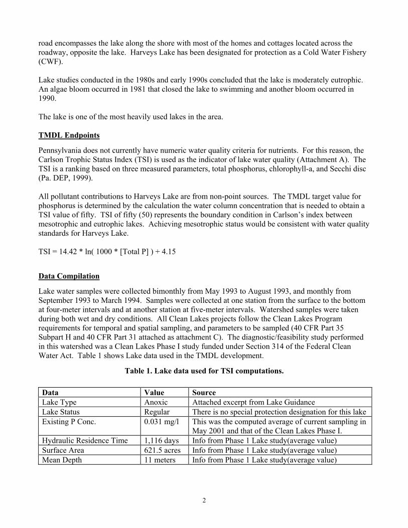
road encompasses the lake along the shore with most of the homes and cottages located across the roadway, opposite the lake. Harveys Lake has been designated for protection as a Cold Water Fishery (CWF). Lake studies conducted in the 1980s and early 1990s concluded that the lake is moderately eutrophic. An algae bloom occurred in 1981 that closed the lake to swimming and another bloom occurred in 1990. The lake is one of the most heavily used lakes in the area. TMDL Endpoints Pennsylvania does not currently have numeric water quality criteria for nutrients. For this reason, the Carlson Trophic Status Index (TSI) is used as the indicator of lake water quality (Attachment A). The TSI is a ranking based on three measured parameters, total phosphorus, chlorophyll-a, and Secchi disc (Pa. DEP, 1999). All pollutant contributions to Harveys Lake are from non-point sources. The TMDL target value for phosphorus is determined by the calculation the water column concentration that is needed to obtain a TSI value of fifty. TSI of fifty (50) represents the boundary condition in Carlson’s index between mesotrophic and eutrophic lakes. Achieving mesotrophic status would be consistent with water quality standards for Harveys Lake. TSI = 14.42 * ln( 1000 * [Total P] ) + 4.15 Data Compilation Lake water samples were collected bimonthly from May 1993 to August 1993, and monthly from September 1993 to March 1994. Samples were collected at one station from the surface to the bottom at four-meter intervals and at another station at five-meter intervals. Watershed samples were taken during both wet and dry conditions. All Clean Lakes projects follow the Clean Lakes Program requirements for temporal and spatial sampling, and parameters to be sampled (40 CFR Part 35 Subpart H and 40 CFR Part 31 attached as attachment C). The diagnostic/feasibility study performed in this watershed was a Clean Lakes Phase I study funded under Section 314 of the Federal Clean Water Act. Table 1 shows Lake data used in the TMDL development.
Table 1. Lake data used for TSI computations. Data Value Source Lake Type Anoxic Attached excerpt from Lake Guidance Lake Status Regular There is no special protection designation for this lake Existing P Conc. 0.031 mg/l This was the computed average of current sampling in
May 2001 and that of the Clean Lakes Phase I. Hydraulic Residence Time 1,116 days Info from Phase 1 Lake study(average value) Surface Area 621.5 acres Info from Phase 1 Lake study(average value) Mean Depth 11 meters Info from Phase 1 Lake study(average value)
2

Biomonitoring was completed on Harveys Lake and included chlorophyll a, phyto- and zooplankton densities, and an assessment of the fisheries. Phosphorus was found to be the limiting nutrient in the lake (Attachment A). The lake is eutrophic at present with elevated phosphorus levels. Derivation of Loading Values and TMDL Computations for Phosphorus The TMDL was computed by the following methods.
1. An existing TSI and Phosphorus loading were computed using the equations contained in the Lake for Windows program "TSI Only" option (see attachment D, excerpt from the Implementation Guidance for Section 95.6-Management of Point Source Phosphorus Discharges to Lakes, Ponds, and Impoundments showing the Reckhow Models and the TSI equation). Refer to page 11 to the TSI analysis titled, "Current Conditions".
Table 2. Summary of TSI Scenarios Scenario In-Lake P
concentration TSI Load(lb/yr)
Current Conditions 0.031 53.7 1,019 Target TMDL 0.024 50.0 789
Watershed loading values were acquired from the AVGWLF model for various sources including farmland, commercial/residential, forest, groundwater and unpaved roads. The AVGWLF model was calibrated using the total phosphorus load to the lake as calculated by the Lake Model minus an internal load. The internal load was assumed to be 25% of the total calculated load (0.25 X 1,019 = 255).
While erosion of the shoreline around Harveys Lake is a major contributor of both solids and phosphorus in localized areas, it is not calculated by AVGWLF. Although AVGWLF does calculate a load from streambank erosion, it does not calculate a load from lake shoreline. The phosphorus load contributed to Harveys Lake from the shoreline surrounding the lake and the tributaries to the lake was set to 150 lb/yr.
Harveys Lake also receives phosphorus contributions from on-site septic systems. The estimate of 33 lb/yr was taken from the Phase I Diagnostic/Feasibility Study of Harveys Lake. This study accounted for septic systems within 330 feet of either the lake shoreline or a tributary, per EPA established criteria, and a per capita phosphorus loading coefficient.
Summing all loads from GWLF and the estimated contributions from internal loading, lake shoreline and septic systems discussed above gives a total current load to the lake of 1,019 lbs TP/yr. These loads are shown below in Table 3. A 10% Margin of Safety (MOS) was initially taken from the computed TMDL Target Load. There are no point sources in the watershed, so the WLA is set to zero.
3

TMDL = LA + WLA + MOS MOS = 0.10 * TMDL Target MOS = 0.10 * 789 = 79 lbs So:
LA = TMDL Target – (MOS + WLA) 710 = 789 – (79 + 0)
The Equal Marginal Percent Removal (EMPR) method was applied to determine the allowable loads from each source required to meet the TMDL target goal (MOS taken out) of 710 lbs TP/yr. These target loads for each land use along with the percent reduction required to meet them are also shown in Table 3.
Table 3. Annual Phosphorus Loading Values (lb/yr)
TOTAL PHOSPHORUS
Land Use Category Area (ac) current load (lb/yr)
TMDL Target (lb/yr)
% reduction annual P load
Farmland 154.7 95 53 44.2 Forest 2841 51 51 0 Developed 499 199 111 44.2 Septic N/A 33 33 0 Unpaved Roads 2.5 3.4 3.4 0 Internal Loading N/A 255 142 44.2 Streambank Erosion N/A 150 84 44.2 Groundwater N/A 233 233 0 Totals 3,541 1,019 710 30 Tables 4 and 5 provide a summary of the TMDL for total phosphorus.
Table 4. Summary of Calculated Load Reduction Parameter Existing Load (lb/yr) TMDL Load (lb/yr)
Total Phosphorus 1,019 789
Table 5. Total Maximum Daily Load Breakdown Parameter LA
(lb/yr) WLA (lb/yr)
MOS (lb/yr)
TMDL
Total Phosphorus 710 0 79 789
4

Consideration of Critical Conditions It is not practical with existing data and resources to explicitly consider critical conditions in terms of both pollutant loading and in-lake conditions. Such an explicit approach would require continuous model simulation of the watershed and lake. Further, by expressing the TMDLs for nutrients as annual loads, both the storm loads and the dry weather loads have been implicitly included. Given that there is generally a significant lag time between the introduction of nutrients to a waterbody and the resulting impact on beneficial uses, establishing this TMDL using average annual conditions is protective. Consideration of Seasonal Variation As stated in the Critical Conditions section, annual loads consider both storm and dry weather loads. Algal blooms have been documented to be a problem during the late summer months, generally characterized by drier seasonal conditions, or low flow conditions. Therefore, this TMDL implicitly considers seasonal variation by expressing the load as an annual average. The annual load encompasses both storm flow and dry weather loads associated with different seasons. Recommendations TMDLs represent an attempt to quantify the pollutant load that may be present in a waterbody and still ensure attainment and maintenance of water quality standards. The Harveys Lake Watershed TMDLs identify the necessary overall load reductions for those pollutants currently causing use impairments and distribute those reduction goals to the appropriate nonpoint sources. Reaching the reduction goals established by these TMDLs will only occur through changes in current land use practices, including the incorporation of more agricultural “best management practices” (BMPs). BMPs that would be helpful in lowering the amount of sediment and nutrients reaching Harveys Lake Watershed include stream bank fencing, riparian buffer strips, strip cropping, contour plowing, conservation crop rotation, and heavy use area protection, among many others. The Natural Resources Conservation Service maintains a National Handbook of Conservation Practices (NHCP), which provides information on a variety of BMPs. The NHCP is available online at http://www.ftw.nrcs.usda.gov/nhcp_2.html. Many of the practices described in the handbook could be used on agricultural lands in Harveys Lake Watershed to help limit siltation and nutrient impairments. Determining the most appropriate BMPs, where they should be installed, and actually putting them into practice, will require the development and implementation of a comprehensive watershed restoration plan. Development of any restoration plan will involve the gathering of site-specific information regarding current land uses and existing conservation practices. The required level of detail is outside the scope of this TMDL document and is an activity best accomplished at the local level. Successful implementation of the activities necessary to address current use impairments to Harveys Lake Watershed will require local citizens taking an active interest in the watershed and the enthusiastic cooperation of local landowners. By developing TMDLs for the Harveys Lake Watershed, the Department has set the stage for local citizens to design and implement restoration plans to correct current use impairments. The Department will support local efforts to develop and implement watershed restoration plans based on the reduction goals specified in the TMDLs. Interested parties should contact the appropriate Watershed Manager in
5

the Department’s North East Regional Office ((570) 826-2368) for information regarding technical and financial assistance currently available. Individuals and/or local watershed groups interested in "fixing" the identified problems in the Harveys Lake Watershed are strongly encouraged to avail themselves of funding sources available through DEP and other state and federal agencies (e.g., Growing Greener or 319 Program). The recommendations contained in the Phase I Clean Lakes Study completed by Coastal Environmental Services in 1994 will be the basis for remediation activities at Harveys Lake. The following list of tasks have been identified as key elements for restoration of the lake.
Task Description1 Fish Survey2 Fish Stocking3 Dredging of Boat Launch Area4 Public Education Program/Nonstructural BMPs 5 Implementation of a Septic Management Program 6 Phase II Monitoring7 Project Documentation8 Catch Basin Upgrades9 Dredging of Outlet Cove10 Dredging of Northwestern Corner of Lake 11 De-Icing Management12 Hypolimnetic Aeration
A recommendation was made in the Phase I report that fish surveys and a fish stocking program be implemented to control alewife populations in the lake to reduce nuisance algal blooms. Although we agree that fish surveys are necessary to document any imbalances in the system that may exist, a biomanipulation study detailing potential impacts of stocking non-native game fish in Harveys Lake must be completed before any such stocking takes place. It has been suggested that there are potential risks involved in any biomanipulation process and this may not be beneficial for Harveys Lake. Replacement of existing catch basins with water quality inlets is highly recommended. A public education program focusing on non-structural BMPs, including alternative landscaping, fertilizing, and pesticide management should be implemented to promote awareness of lake and watershed interactions. The Clean Lakes Study has identified other sources of nutrient runoff that needs to be addressed. Runoff from residential and commercial land use areas need to be addressed along with other land use categories targeted for load reductions. To support this effort, education of the public concerning nutrient and sediment runoff needs to occur. Implementation of the remediation plan has begun with the approval of a $100,000 grant from the Pennsylvania Nonpoint Source Program to the Harveys Lake Environmental Advisory Council and Harveys Lake Borough. This project will begin to implement some of the tasks identified in the restoration plan listed above.
6

Public Participation
Public notice of the draft TMDL was published in the Pennsylvania Bulletin and local newspapers with a 60-day comment period that ended on February 12, 2003. A public meeting was held concurrent to these published notices at the Harveys Lake General Municipal Authority to discuss the proposed TMDL plan. Notice of final plan approval will be published in the PA Bulletin.
7
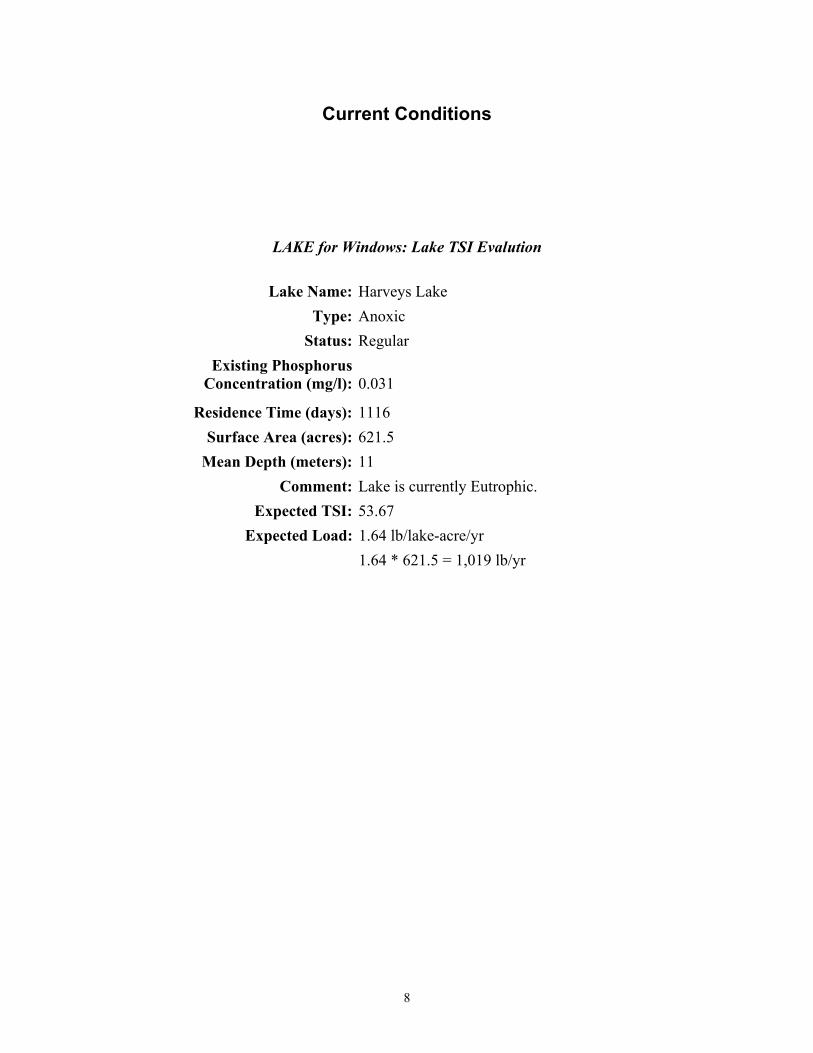
Current Conditions
LAKE for Windows: Lake TSI Evalution
Lake Name: Harveys Lake Type: Anoxic Status: Regular Existing Phosphorus Concentration (mg/l): 0.031 Residence Time (days): 1116 Surface Area (acres): 621.5 Mean Depth (meters): 11 Comment: Lake is currently Eutrophic. Expected TSI: 53.67 Expected Load: 1.64 lb/lake-acre/yr 1.64 * 621.5 = 1,019 lb/yr
8

TSI 50
LAKE for Windows: Lake TSI Evalution
Lake Name: Harveys Lake Type: Anoxic Status: Regular Existing Phosporous Concentration (mg/l): 0.024 Residence Time (days): 1116 Surface Area (acres): 621.5 Mean Depth (meters): 11 Comment: Lake is currently mesotrophic. Expected TSI: 49.98 Expected Load: 1.27 lb/lake-acre/yr 1.27 * 621.5 = 789 lb/yr
9


Comment and Response Document Comment: Please expand the problem definition to elaborate on why nutrients and
sediments are a problem in Harveys Lake. Also, discuss how the proliferation of alewife in Harveys Lake has affected the water quality and/or designated use of the lake. The fecal coliform problems should be mentioned, as well, with a brief discussion of how they will be addressed in the future. (1)
Response: Comment addressed in document text. Currently Harveys Lake is not listed on the 303(d) list as being impaired due to fecal coliform. If sufficient data become available to list Harveys Lake as impaired by fecal coliforms, that impairment will be addressed in the future.
Comment: It is our understanding that the historical sediment problem in Harveys Lake is localized
sediment accumulation rather than total suspended solids (TSS), and that the initial TSS listing in 1996 was probably an administrative error resulting from limited categories for classifying pollution sources. If so, then this should be mentioned. PADEP should discuss whether the sedimentation has impacted the designated use of Harveys Lake. (1)
Response: A detailed discussion of this issue appeared in the Introduction section of the TMDL. Comment: Consider including East Fork Harveys Creek in the TMDL analysis. (1) Response: East Fork Harveys Creek has been surveyed and deemed impaired; however, it will not be
included in this TMDL report. At this point, the source/cause of the impairment in the East Fork is not well understood. East Fork Harveys Creek on the Section 303(d) list for Organic Enrichment/Low D.O. from natural sources and “other” sources. More time is needed to fully understand the causes of impairment in the East Fork before a TMDL is completed.
Comment: Include the official designated use for Harveys Lake. (1) Response: Comment addressed in document text. Comment: Discuss the rationale for selecting a Trophic Status Index (TSI) value of 50
in terms of the current trophic status of the lake and how the future trophic status (TSI = 50) will be expected to meet water quality standards and
protect the Lake’s designated use. (1) Response: Comment addressed in document text. Comment: Suggest including the TSI equation as a function of total phosphorus. (1) Response: Comment addressed in document text. Comment: We recognize that PADEP’s listing procedure uses the descriptor “nutrients” as a pollutant
cause and that low dissolved oxygen (D.O.) is not listed specifically as an impairment. However, the report should discuss how this TMDL will address any other nutrient-related

problems in Harveys Lake, such as low D.O. conditions, to the extent they are not naturally occurring. (1)
Response: The comment does not correctly state Pennsylvania’s listing procedure. If
dissolved oxygen problems are documented (i.e. D.O. concentrations below criteria in the surface mixed layer), the lake is listed for a D.O. impairment. However, no oxygen depletion in the epilimnion was documented in Harveys Lake; therefore, the TMDL will not speculate as to how D.O. will be affected by the nutrient reductions prescribed by the TMDL.
Comment: Include the results of the May 2001 sampling and any other sampling efforts since 1994.
Present a data summary for TN, TP, chlorophyll-a, dissolved oxygen, and any other relevant parameters. Mention for what the samples were analyzed. (1)
Response: Attached as an appendix Comment: Discuss the derivation of the Margin of Safety (i.e. 10% of the total TMDL
estimate). It may be confusing where the TMDL target goal is alternately listed as 710 and 789 lb/yr. (1)
Response: Comment addressed in document text. Comment: Explain the connection between the estimates of current/future TSI as determined using
the LAKE model and the current/future watershed loading estimates from the AVGWLF model. Show the units on the LAKE loads shown on pages 9-10 (lb/ac/yr) and show the conversion to lb/yr in Table 2. (1)
Response: Comment addressed in document text. Comment: Explain why no phosphorus reductions are targeted for the low and high intensity
development land use areas. (1)
Response: Document has been changed to address this comment. Comment: Discuss how follow-up monitoring will be performed to track the effectiveness of control
measures. (1)
Response: Current section 319 grant projects on Harveys Lake include monitoring plans. Comment: Who will be responsible for full funding and implementing control measures? Although
not required for nonpoint source-only TMDLs, can PADEP provide reasonable assurances that these control measures will achieve the targeted phosphorus load reductions and resolve the sedimentation problems? (1)
Response: PADEP provides grant funding for implementation of TMDLs through a variety of
programs.
Comment: As part of the Phase I Diagnostic / Feasibility Study of Harvey’s Lake (Coastal 1994), the Unit Areal Loading (UAL) model was used to quantify the non-point source (NPS) pollutant loads originating from surface runoff. In contrast, the AVGWLF model, developed by the Pennsylvania State University, was used to model surface runoff as part of the development of the TMDL. The more detailed components of the AVGWLF model (i.e. unpaved roads, streambank erosion) have the capacity to provide a more detailed assessment of the watershed-based sources of NPS. Thus, the selection of the AVGWLF model was a good choice in developing the TMDL for Harvey’s Lake. (2)

Response: Thank you. Comment: It was estimated as part of the Phase I study that approximately 200 to 300 homes within
the Harveys Lake watershed have on-site wastewater disposal systems (i.e. septic systems). However, as based on criteria established by USEPA, only those septic systems that are located within 330 feet of either the lake shoreline or an associated tributary are considered to be net sources of phosphorus for the lake. Based on these criteria, only 20 septic systems can be considered as net sources of phosphorus for the lake. Thus, based on these conditions, the septic contribution to Harveys Lake was estimated to be 33 lbs per year. In contrast, the phosphorus load calculated for the Harveys Lake TMDL was 100 lbs per year. This estimate may be based on including all of the existing septic systems within the watershed, instead of those located within 330 feet of the shoreline or an associated tributary. (2)
Response: AVGWLF uses an empirical calculation based on total number of systems in the
watershed and an assumption regarding the percentage of those systems that are not functioning properly. The TMDL has been adjusted to reflect the more detailed conditions under which a system is considered a net source of phosphorus to the lake.
Comment: Another issue of concern was the phosphorus load originating from the various types of
land within the watershed. Under the TMDL analysis high intensity development, which was assumed to be commercial land accounted for only 2% of the land area and less than 0.05% of the annual surface runoff phosphorus load. This estimated phosphorus load, originating from land with impervious surfaces, seems unusually low. Another important component to the on-site conditions within the Harveys Lake watershed is that the vast majority of the commercial and residential land is located immediately adjacent to the lake. Such conditions exacerbate the impact of the NPS pollutant loads generated from these land types, since this is little or no opportunity of reducing these loads prior to them entering the lake. (2)
Response: One drawback to the AVGWLF model is that it has no spatial component associated with
any given landuse. The model estimates the area of each land use, but the location of those areas are not taken into account. Your point regarding the commercial and residential land being directly adjacent to the lake is valid and appreciated, adjustments were made to account for discrepancies between model estimates of the area and phosphorus contribution of commercial and residential land in the Harveys Lake watershed.
Comment: One component of the draft TMDL that was not addressed in the Phase I study was
streambank erosion. Based on existing conditions, this component of the watershed was required and should be included in the overall implementation plan for the lake and watershed. Also, the internal load calculated under the TMDL was similar to the internal load calculated under the Phase 1 study. In addition, the selected TMDL endpoint of the phosphorus TSI for the lake certainly seems appropriate, as does the targeted reduction of approximately 200 lbs of phosphorus per year. However, I strongly feel that the bulk of the watershed-based phosphorus is originating from developed land and not farmland. (2)
Response: Thank you for the supporting comments. We have addressed your concerns regarding the
loads contributed by different land uses in the revised TMDL document.

LIST OF COMMENTATORS
1. Thomas Henry, Acting Chief PA/DE Branch Office of Watersheds United States Environmental Protection Agency Region III 1650 Arch Street Philadelphia, PA 19103-2029 2. Fred D. Lubnow, Ph.D. Director of Aquatics Program Princeton Hydro, LLC 1108 Old York Road Suite 1, P.O. Box 720 Ringoes, NJ 08551