habitat regulations assessment
TRANSCRIPT
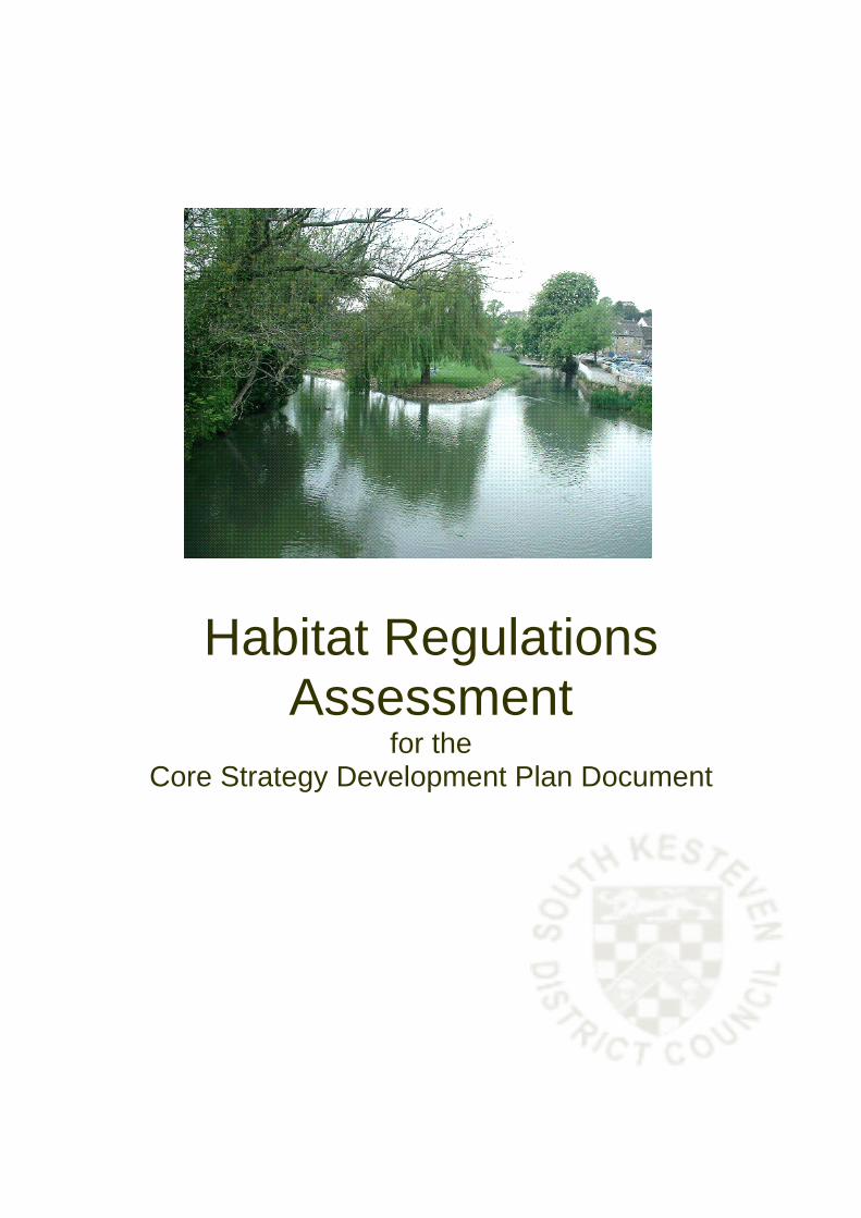
Habitat Regulations Assessment
for the Core Strategy Development Plan Document
SOUTH KESTEVEN DISTRICT COUNCIL CORE STRATEGY HABITATS REGULATIONS ASSESSMENT
INTRODUCTION The purpose of a Habitats Regulations Assessment is to enable any impacts that land-use plans will have on European Sites to be assessed. The assessment must determine whether the plan would adversely affect the integrity of the site in terms of its nature conservation objectives. Where negative effects are identified other options should be examined to avoid any potential damaging effects. European Sites are nature conservation sites designated as Special Protection Areas (SPAs) and Special Areas of Conservation (SACs). HABITATS REGULATIONS ASSESSMENT REQUIREMENTS The requirement for Assessment of plans or projects affecting Natura 2000 sites is set out in The Habitats Directive (Council Directive 92/43/EEC). Article 6(3) establishes the requirement for Assessment and states: “ (3) Any plan or project not directly connected with or necessary to the management of the site but likely to have a significant effect thereon, either individually or in combination with other plans and projects, shall be subject to Appropriate Assessment of its implications for the site in view of the site’s conservation objectives. In the light of the conclusions of the assessment of the implications for the site and subject to the provisions of paragraph 4, the competent national authorities shall agree to the plan or project only after having ascertained that it will not adversely affect the integrity of the site concerned and, if appropriate, after having obtained the opinion of the general public." Article 6(4) goes on to discuss alternative solutions and compensatory measures. It states: "(4) If, in spite of a negative assessment of the implications for the site and in the absence of alternative solutions, a plan or project must nevertheless be carried out for imperative reasons of overriding public interest, including those of social or economic nature, the Member State shall take all compensatory measures necessary to ensure that the overall coherence of Natura 2000 is protected. It shall inform the Commission of the compensatory measures adopted.” Natura 2000 is a Europe-wide network of sites of international importance for nature conservation established under the European Council Directive ‘on the
1
conservation of natural habitats and of wild fauna and flora’ – (92/43/EEC ‘Habitats Directive’). This Directive has been transposed into UK law as the Conservation (Natural Habitats &c.) Regulations (1994; ‘Habitats Regulations’). Natura 2000 sites include Special Areas of Conservation (SAC) and candidate Special Areas of Conservation (cSAC), which are designated under the Habitats Directive (92/43/EEC), and Special Protection Areas (SPA) classified under the ‘Birds Directive’ (79/409/EEC). Government policy in Planning Policy Statement 9: Biodiversity and Geological Conservation (PPS9) paragraph 6, extends the requirement for assessment to Ramsar sites. These sites support internationally important wetland habitats and are listed under the Convention on Wetlands of International Importance especially as Waterfowl Habitat (Ramsar Convention, 1971), although they are not strictly part of Natura 2000. ACTIVITIES WITH POTENTIAL TO HAVE SIGNIFICANT IMPACT It is anticipated that the following activities could have significant effects upon the integrity of the SACs/SPAs: • on site development: loss of habitat • development nearby: disturbance to, and possible loss of, habitat, air
pollution caused by increased traffic movements • recreational activity: physical damage by trampling, noise and visual
presence, by walking, driving, fishing etc, air pollution caused by increased traffic movements
• water abstraction: water levels could be affected • livestock grazing: disturbance to, and possible loss of, habitat • agricultural activity: contamination from farming operations, including run-
off into waterways. HABITATS REGULATIONS ASSESSMENT METHODOLOGY There are 4 stages to the Habitats Directive Assessment process set out in the European Commission guidance “Assessment of plans and projects significantly affecting Nature 2000 sites – Methodological guidance on the provisions of Article 6(3) and (4) of the Habitats Directive 92/43/EEC” (November 2001:
2
1 - Screening To identify the likely impacts of a plan or project (alone or in combination with others) upon a Natura 2000 site, and to consider whether these impacts are likely to be significant. 2 - Appropriate Assessment To consider the impact of a plan or project (alone or in combination with others) on the integrity of the Natura 2000 site, with respect to the site’s structure and function and it’s conservation objectives. Where there are adverse impacts, an assessment of the potential mitigation of those impacts. 3 - Assessment of alternative solutions To examine alternative ways of achieving the objectives of the project or plan which avoid adverse impacts on the integrity of the Natura 2000 site. If, after mitigation, there will still be a negative effect on the integrity of a European site, the plan should be dropped. The only exceptions are where it can be shown that there are 'imperative reasons of overriding public interest'. 4 - Compensatory measures To assess compensatory measures where it is decided that the plan should proceed because of overriding public interest. If, after the screening stage, it is concluded that there will be no significant impacts, there is no need to carry out subsequent stages. This Screening Report addresses the First Stage only of the Habitats Directive Assessment process. SCREENING This stage of the assessment process requires the following steps to be undertaken: 1 - Identification of sites which may be affected 2 - Analysis of sites 3 - Analysis and assessment of the plan or project 4 - Conclusion
3
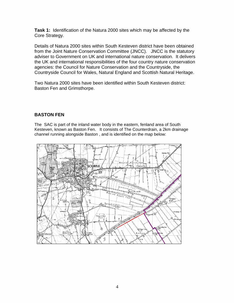
Task 1: Identification of the Natura 2000 sites which may be affected by the Core Strategy. Details of Natura 2000 sites within South Kesteven district have been obtained from the Joint Nature Conservation Committee (JNCC). JNCC is the statutory adviser to Government on UK and international nature conservation. It delivers the UK and international responsibilities of the four country nature conservation agencies: the Council for Nature Conservation and the Countryside, the Countryside Council for Wales, Natural England and Scottish Natural Heritage. Two Natura 2000 sites have been identified within South Kesteven district: Baston Fen and Grimsthorpe. BASTON FEN The SAC is part of the inland water body in the eastern, fenland area of South Kesteven, known as Baston Fen. It consists of The Counterdrain, a 2km drainage channel running alongside Baston , and is identified on the map below:
4
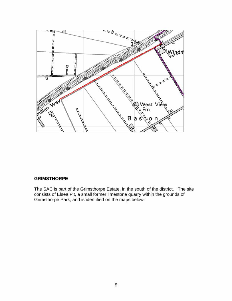
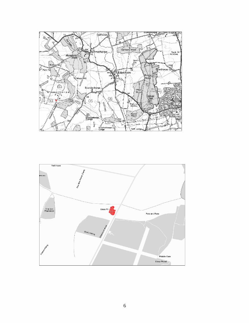
GRIMSTHORPE The SAC is part of the Grimsthorpe Estate, in the south of the district. The site consists of Elsea Pit, a small former limestone quarry within the grounds of Grimsthorpe Park, and is identified on the maps below:
5
6
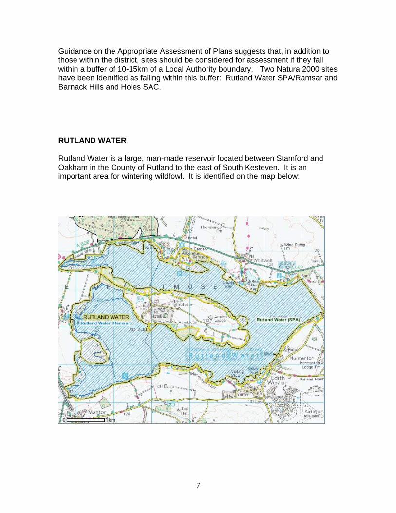
Guidance on the Appropriate Assessment of Plans suggests that, in addition to those within the district, sites should be considered for assessment if they fall within a buffer of 10-15km of a Local Authority boundary. Two Natura 2000 sites have been identified as falling within this buffer: Rutland Water SPA/Ramsar and Barnack Hills and Holes SAC. RUTLAND WATER Rutland Water is a large, man-made reservoir located between Stamford and Oakham in the County of Rutland to the east of South Kesteven. It is an important area for wintering wildfowl. It is identified on the map below:
7
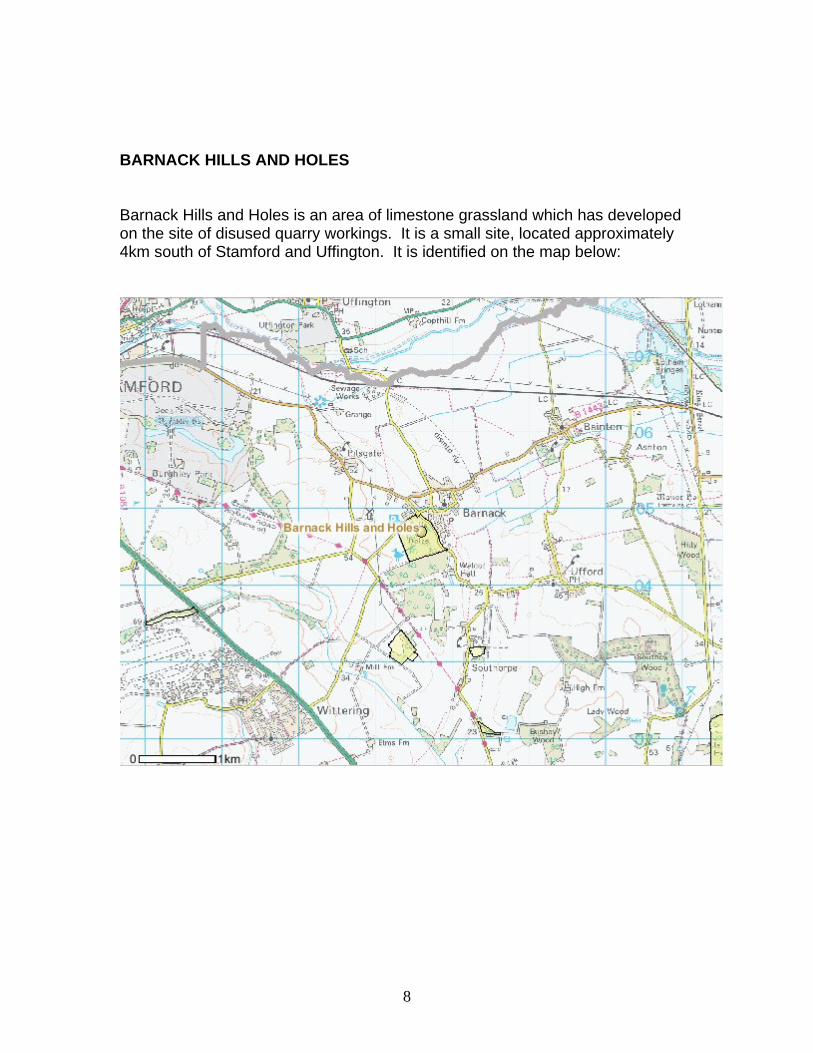
BARNACK HILLS AND HOLES Barnack Hills and Holes is an area of limestone grassland which has developed on the site of disused quarry workings. It is a small site, located approximately 4km south of Stamford and Uffington. It is identified on the map below:
8
Task 2: Analysis of the Natura 2000 sites which may be affected by the Core Strategy. BASTON FEN Baston Fen SAC consists of a 2km long main drain, the Counterdrain, which runs alongside Baston Fen. It is intensively managed by Welland and Deeping Internal Drainage Board. The drain retains a high population of Spined loach Cobitis taenia. The patchy cover from submerged plants provides excellent habitat for the species. The Spined loach is a species included in Annex II of the Directive, and its presence is the primary reason for the selection of this site as a Special Area of Conservation (SAC). The Lincolnshire Biodiversity Action Plan (BAP) reports that the spined loach population in Lincolnshire appears to be healthy, and does not appear to be in serious danger. However, "its apparently fragmented distribution in highly regulated rivers and drains means that it is potentially vulnerable to changes in river/land use". [Lincolnshire BAP 2005-2007] The Baston Fen SAC falls within the type of habitat described by the Lincolnshire 2006 BAP as Rivers, Canals and Drains. Its report highlights threats to these habitats resulting from intensive use of the county's rural landscape and the use and quality of water within individual watercourses. The BAP lists the following problems which are inherent with high maintenance drainage systems, such as the Baston Fen SAC: • Water abstraction • Chemical enrichment and pollution. • Navigational and flood defence structures and impoundments. • Climate change • Land drainage and the management of waterways, • Fishing and fish farming. • Development within the floodplain. • Loss of native fauna through swamping of introduced exotic species. The BAP shows that the Environment Agency, together with partners including the Internal Drainage Boards, British Waterways, Lincolnshire Wildlife Trust and landowners, have ongoing programmes to ensure the safeguarding and management of the SAC as well as management and protection of the species.
9
GRIMSTHORPE The Grimsthorpe SAC is a small part, around 0.35ha, of the park and gardens belonging to the Grimsthorpe Estate. The estate itself covers around 3,000 acres of the south Lincolnshire countryside between Bourne and Stamford. The site, known as Elsea Pit, is a small former limestone quarry, and is managed under the terms of a Manageent Agreement with English Nature. Grimsthorpe is the most northerly outpost for early gentian Gentianella anglica, with 2-3 colonies totalling several hundred plants in old oolitic limestone quarries. The site is semi-natural dry grasslands and scrubland, and is on the northern limit for Gentianella anglica in the UK. The JNCC reports that not all of the site is a suitable habitat for the early gentian and there is little scope for increasing its area. The early gentian is a species included in Annex II of the Directive, and its presence is the primary reason for the selection of this site as a Special Area of Conservation (SAC). The UK Biodiversity Action Plan records that the early gentian is endemic to the UK and occurs in only a few sites, and that it is also listed as vulnerable on the GB Red List. [://www.ukbap.org.uk]. The JNCC report that there has been a marked decline in the species. This is mainly because old chalk grasslands have been ploughed grazing has been abandoned on much of the grasslands which remain. The UK BAP agrees that the threats to the species are the loss of suitable habits and inappropriate management, especially reductions in grazing. JNCC reports that, at Grimsthorpe, there are arrangements for the erection of electric fencing around the site to enable light grazing with sheep or cattle to take place. RUTLAND WATER Rutland Water consists of a large man-made reservoir occupying some 1,556 ha in Rutland which is an important are for wintering wildfowl. A nature reserve occupies a narrow strip of land of some 600 acres running for 9 miles round the western end. The reserve is owned by Anglian Water and managed by the Leicestershire & Rutland Wildlife Trust. The reserve is a Site of Special Scientific Interest, a Ramsar site and a European Special Protection Area. The site is also a popular tourist attraction: fishing, walking, cycling and bird watching are among the recreational pursuits on offer. The JNCC report that the
10

management of the site for its SPA interests is largely compatible with the recreational uses. BARNACK HILLS AND HOLES Barnack Hills and Holes is an area of limestone grassland which has developed on the site of disused quarry workings. The 23ha site is leased to, and managed by, Natural England. It was designated as a Special Area for Conservation in 2005 to protect the orchid-rich grassland. The site has public access, which is controlled by the provision of gates and stiles. The management plan includes annual grazing by sheep, wardening and seasonal closures of the site. The JNCC reports that these measures control visitor pressures. Task 3: Analysis and assessment of the plan or project. This stage of the process is to determine whether the issues and options being assessed will have any significant effect on the Natura 2000 site. South Kesteven District Council is preparing its Local Development Framework (LDF): a suite of documents which provide the overarching planning policy for the district. The policies within this framework will, therefore, have possible impacts on the SACs and SPA. Each of these must be assessed to determine whether they will have any significant effects upon the sites. The Core Strategy is the first of the LDF documents to be prepared, and it is the policies in this document that are to be assessed for impacts on the SACs and SPA. The Core Strategy is the overarching document of the LDF. It informs all the other policy and guidance documents included within the LDF. It does not identify specific sites for development: these will be brought forward in a site allocation document at a later stage. The purpose of the Core Strategy is to provide the spatial policy framework for development and change in the district and establishes the key principles which guide the location, use and form of development.
11
The Core Strategy document contains the following policies: SP1 Spatial Strategy SP2 Sustainable Communities SP3 Sustainable Integrated Transport SP4 Developer Contributions EN1 Protection and Enhancement of the Character of the District EN2 Reducing the Risk of Flooding EN3 Renewable Energy Generation EN4 Sustainable Construction and Design H1 Residential Development H2 Urban Extension Sites (Grantham) H3 Affordable Housing H4 Gypsies and Travellers H5 Travelling Showpeople E1 Employment Development E2 Town Centre and Retail Development The overarching framework for development within the district is provided by the Spatial Strategy (SP1) and the Sustainable Communities Policy (SP2). These set out the locational strategy to be adopted when allocating land for development and when considering development proposals. In all cases, priority will be given to previously developed land, although development will be permitted on appropriate greenfield sites. Development in village and rural locations is restricted. The focus of new development will be in Grantham, to support and strengthen its role as a Sub-Regional Centre. These policies allow for growth to maintain and support the market towns of Stamford, Bourne and the Deepings, as well as the larger villages, including those settlements which have been identified as Local Service Centres. Development in rural areas is directed to those settlements where localised service use is already strong, to ensure that they remain sustainable. This approach will be used to assess all development proposals, whether residential, employment, retail, leisure and other uses. With the exception of the policy for Urban Extension Sites (H2), there are no locations for development identified. The locations identified are all in the town of Grantham. In broad terms, therefore, it can be seen that development is unlikely to occur in the areas of Baston Fen and the Grimsthorpe SACs. Water abstraction has been highlighted as a possible threat to sites such as Baston Fen. However, this site is intensively managed by the Welland and Deeping Internal Drainage Board,
12
and it is expected that, should development in other areas pose a threat to the site, mitigation measures would be demanded. The housing figures are derived directly from the East Midlands Regional Plan (RSS) which has undergone HRA. They have been deemed acceptable, subject to certain safeguards. Water Resource Management Plans produced for the Region suggest that the planned levels of development can be accommodated without affecting Rutland Water SPA. The HA of the RSS also concluded that, whilst recreation pressure on Barnack Hills and Holes SAC is an issue, this is unlikely to be increased by development within the East Midlands area. On-site management measures are in place to keep damage under control. In addition to the LDF, the following documents provide policy relevant to the South Kesteven district: • East Midlands Integrated Regional Strategy (2005) • East Midlands Regional Plan (Regional Spatial Strategy) • Lincolnshire Waste Local Plan • Lincolnshire Minerals Local Plan • Lincolnshire Transport Plan The key points from these policies can be summed up as follows: Environmental: to protect, maintain and enhance the natural environment, with particular attention to designated sites at regional, national and international level. The importance of maintaining and enhancing the biodiversity of the area is highlighted. The environmental policies all seek to reduce the impact on the countryside and the environment generally, through policies which: • protect the best agricultural land • prioritise the use of brownfield land • reduce harmful emissions and improve local air quality • minimise the disposal of waste by landfill • making efficient use of existing infrastructure • seek to reduce emissions of greenhouse gases • maintain and improve public open space • protect trees and woodland • have regard to the character and distinctiveness of the landscape These documents stress the importance of minimising environmental loss that could occur through development proposals and of ensuring that any development is compatible with the interests of rural conservation. The potential of, and the need to promote, renewable energy is also highlighted in these documents. These emphasise the need to consider carefully proposals
13
14
for the siting and construction of windfarms and other methods of producing renewable energy. Economic: to support the local economy and maintain the vitality and viability of the town centres. Support for rural diversification schemes is also emphasised. A major concern is to minimise the environmental impacts of any industrial and commercial development, although these can only be assessed on a site by site basis. Social: to improve social well-being by improving the quality of life for all residents. The main points arising from these policies are: • housing (market and affordable) to be high quality and range of sizes • encourage walking, cycling and public transport • reduce the need to travel • maintain and improve public open space and recreation provision The need to ensure that development does not cause harm to the environment is a central tenet of all current policies, although this has to be balanced with the need to provide housing and employment opportunities for the resident population. Task 4: Conclusions. The Policies contained within the South Kesteven District Council Core Strategy DPD have been assessed to determine whether there are likely to be any significant effects arising from them, in accordance with the Habitats Directive. This assessment has identified the European Sites that may potentially be affected by the Core Strategy policies. The characteristics of each site have been examined and the policies tested to identify any significant impacts on the European Sites. This assessment concludes that the policies within the South Kesteven Core Strategy DPD are not likely to have any significant effects on any Natura 2000 site. There is, therefore, no requirement to proceed to the next stage of an Appropriate Assessment.
APPENDIX 1: NATURA 2000 SITES WITHIN SOUTH KESTEVEN SITE NAME: BASTON FEN Designation: Special Area of Conservation (SAC), (also part of SSSI) Code: UK0030085 Location: Drainage channel adjacent to Baston Fen. Grid ref: TL 136171 Latitude: 524421 N Longitude 001901 W Area 2.2 ha General Site characteristics Inland water body (standing water, running water) (100%) Soil and geology: Alluvium, Clay, Neutral Geomorphology and landscape: Floodplain, Lowland Primary reason for selection of the site The presence of the Spined loach Cobitis taenia, a species appearing in Annex II of the Habitats Directive. Species Spined loach Cobitis taenia is a small bottom-living fish that has a restricted microhabitat associated with a specialised feeding mechanism. They use a complex branchial apparatus to filter-feed in fine but well-oxygenated sediments. Optimal habitat is patchy cover of submerged (and possibly emergent) macrphytes, which are important for spawning, and a sandy (also silty) substrate, into which juvenile fish tend to bury themselves. The Spined loach Cobitis taenia has an extremely wide distribution across Europe and Asia. Even with such a broad range and ecological niche it is generally regarded as threatened, if not rare, in Europe. In the UK, Spined loach Cobitis taenia appears to be restricted to just five east-flowing river systems in eastern England: the rivers Trent, Welland, Witham, Nene and Great Ouse, with their associated waterways (Perrow & Jowitt 2000). Within these catchments it appears to occur patchily in a variety of waterbodies, including small streams, large rivers and both large and small drainage ditches. Little is known about its occurrence in open water, although it is known from a number of small lakes and gravel-pits. With limited means of dispersal, the UK populations are largely genetically isolated from each other. Site Description The Baston Fen SAC is a 2km long drainage channel, The Counterdrain, running alongside Baston Fen. It contains high densities of Spined loach Cobitis taenia, and is an example of spined loach populations in the Welland catchment. The patchy cover from submerge plants provides excellent habitat for the species.
Vulnerability Baston Fen SAC is intensively managed by Welland and Deeping Internal Drainage Board. The drain retains a high population of spined loach and a rich aquatic flora but the effects of drain management on the European interest are presently unknown and require further investigation. The Lincolnshire Biodiversity Action Plan (2005-2007) records that the population of Spined loach in Lincolnshire appears to be healthy, data having been collected for the past 20 years from routine fish surveys, although it is not possible to quantify the populations. The fish are found only in a few locations. While it does not appear to be in serious danger, it is this fragmented distribution in highly regulated rivers and drains which means that it is potentially vulnerable to changes in river/land use. SITE NAME: GRIMSTHORPE Designation: Special Area of Conservation (SAC), (also part of SSSI) Code: UK0030043 Location: Former limestone quarry within the grounds of
Grimsthorpe Park. Grid ref: TL 033205 Latitude: 524619 N Longitude 002809 W Area 0.35 ha General Site characteristics Dry Grassland. Steppes (85/7%) Inland rocks. Screes. Sands. Permanent snow and ice (14.3%) Soil and geology: Basic, Limestone, Sedimentary Geomorphology and landscape: Lowland Primary reason for selection of the site The presence of Early gentian Gentianella anglica, a species appearing in Annex II of the Habitats Directive. Annex I habitats present as a qualifying feature, but not a primary reason for selection of site Semi-natural dry grasslands and scrubland facies: on calcareous substrates (Festuco-Brometalia) Species Early gentian Gentianella anglica is an annual plant, which occurs in calcareous grassland, mainly on steep, south-facing slopes. It grows on bare ground or in thin turf that is kept open by a combination of rabbit or sheep-grazing and trampling by livestock on thin droughted soils. In dense turf it
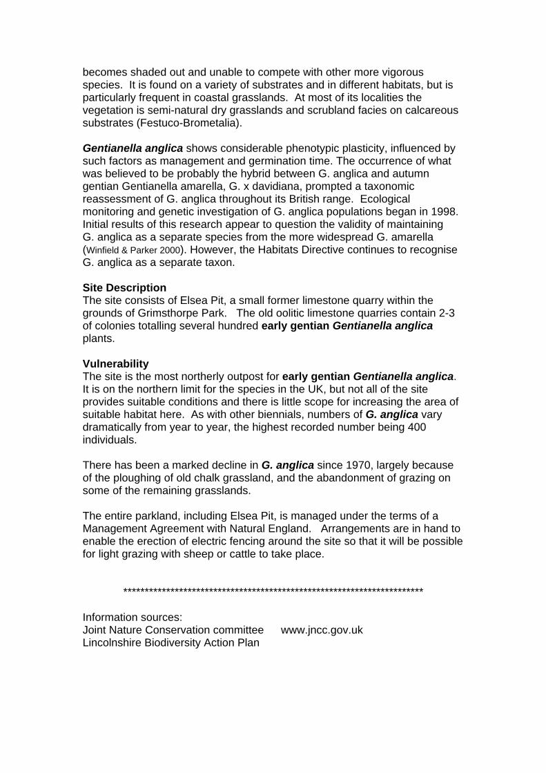
becomes shaded out and unable to compete with other more vigorous species. It is found on a variety of substrates and in different habitats, but is particularly frequent in coastal grasslands. At most of its localities the vegetation is semi-natural dry grasslands and scrubland facies on calcareous substrates (Festuco-Brometalia). Gentianella anglica shows considerable phenotypic plasticity, influenced by such factors as management and germination time. The occurrence of what was believed to be probably the hybrid between G. anglica and autumn gentian Gentianella amarella, G. x davidiana, prompted a taxonomic reassessment of G. anglica throughout its British range. Ecological monitoring and genetic investigation of G. anglica populations began in 1998. Initial results of this research appear to question the validity of maintaining G. anglica as a separate species from the more widespread G. amarella (Winfield & Parker 2000). However, the Habitats Directive continues to recognise G. anglica as a separate taxon. Site Description The site consists of Elsea Pit, a small former limestone quarry within the grounds of Grimsthorpe Park. The old oolitic limestone quarries contain 2-3 of colonies totalling several hundred early gentian Gentianella anglica plants. Vulnerability The site is the most northerly outpost for early gentian Gentianella anglica. It is on the northern limit for the species in the UK, but not all of the site provides suitable conditions and there is little scope for increasing the area of suitable habitat here. As with other biennials, numbers of G. anglica vary dramatically from year to year, the highest recorded number being 400 individuals. There has been a marked decline in G. anglica since 1970, largely because of the ploughing of old chalk grassland, and the abandonment of grazing on some of the remaining grasslands. The entire parkland, including Elsea Pit, is managed under the terms of a Management Agreement with Natural England. Arrangements are in hand to enable the erection of electric fencing around the site so that it will be possible for light grazing with sheep or cattle to take place.
**********************************************************************
Information sources: Joint Nature Conservation committee www.jncc.gov.uk Lincolnshire Biodiversity Action Plan
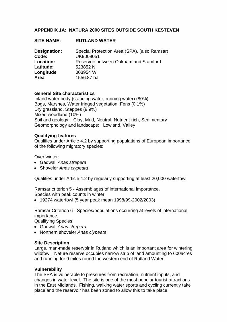
APPENDIX 1A: NATURA 2000 SITES OUTSIDE SOUTH KESTEVEN SITE NAME: RUTLAND WATER Designation: Special Protection Area (SPA), (also Ramsar) Code: UK9008051 Location: Reservoir between Oakham and Stamford. Latitude: 523852 N Longitude 003954 W Area 1556.87 ha General Site characteristics Inland water body (standing water, running water) (80%) Bogs, Marshes, Water fringed vegetation, Fens (0.1%) Dry grassland, Steppes (9.9%) Mixed woodland (10%) Soil and geology: Clay, Mud, Neutral, Nutrient-rich, Sedimentary Geomorphology and landscape: Lowland, Valley Qualifying features Qualifies under Article 4.2 by supporting populations of European importance of the following migratory species: Over winter: • Gadwall Anas strepera • Shoveler Anas clypeata Qualifies under Article 4.2 by regularly supporting at least 20,000 waterfowl. Ramsar criterion 5 - Assemblages of international importance. Species with peak counts in winter: • 19274 waterfowl (5 year peak mean 1998/99-2002/2003) Ramsar Criterion 6 - Species/populations occurring at levels of international importance. Qualifying Species: • Gadwall Anas strepera • Northern shoveler Anas clypeata Site Description Large, man-made reservoir in Rutland which is an important area for wintering wildfowl. Nature reserve occupies narrow strip of land amounting to 600acres and running for 9 miles round the western end of Rutland Water. Vulnerability The SPA is vulnerable to pressures from recreation, nutrient inputs, and changes in water level. The site is one of the most popular tourist attractions in the East Midlands. Fishing, walking water sports and cycling currently take place and the reservoir has been zoned to allow this to take place.
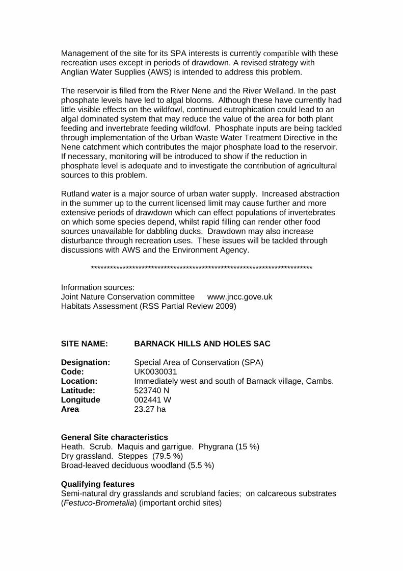
Management of the site for its SPA interests is currently compatible with these recreation uses except in periods of drawdown. A revised strategy with Anglian Water Supplies (AWS) is intended to address this problem. The reservoir is filled from the River Nene and the River Welland. In the past phosphate levels have led to algal blooms. Although these have currently had little visible effects on the wildfowl, continued eutrophication could lead to an algal dominated system that may reduce the value of the area for both plant feeding and invertebrate feeding wildfowl. Phosphate inputs are being tackled through implementation of the Urban Waste Water Treatment Directive in the Nene catchment which contributes the major phosphate load to the reservoir. If necessary, monitoring will be introduced to show if the reduction in phosphate level is adequate and to investigate the contribution of agricultural sources to this problem. Rutland water is a major source of urban water supply. Increased abstraction in the summer up to the current licensed limit may cause further and more extensive periods of drawdown which can effect populations of invertebrates on which some species depend, whilst rapid filling can render other food sources unavailable for dabbling ducks. Drawdown may also increase disturbance through recreation uses. These issues will be tackled through discussions with AWS and the Environment Agency.
**********************************************************************
Information sources: Joint Nature Conservation committee www.jncc.gove.uk Habitats Assessment (RSS Partial Review 2009) SITE NAME: BARNACK HILLS AND HOLES SAC Designation: Special Area of Conservation (SPA) Code: UK0030031 Location: Immediately west and south of Barnack village, Cambs. Latitude: 523740 N Longitude 002441 W Area 23.27 ha General Site characteristics Heath. Scrub. Maquis and garrigue. Phygrana (15 %) Dry grassland. Steppes (79.5 %) Broad-leaved deciduous woodland (5.5 %) Qualifying features Semi-natural dry grasslands and scrubland facies; on calcareous substrates (Festuco-Brometalia) (important orchid sites)

Site Description Small, disused limestone quarry on the outskirts of Barnack village. Access on foot only. Circular limestone walk through reserve. Vulnerability The site is leased to, and managed by, Natural England. A management plan is in place. The site is grazed annually by sheep in association with a programme of scrub control to maintain appropriate habitat conditions for grassland flora and fauna. There is public access to the site and a public footpath crosses the southern half. Access is controlled by the provision of grates and stiles. There is high visitor pressure that is controlled by wardening, losing parts of the reserve seasonally, education and interpretation.
**********************************************************************
Information sources: Joint Nature Conservation committee www.jncc.gove.uk Habitats Assessment (RSS Partial Review 2009)
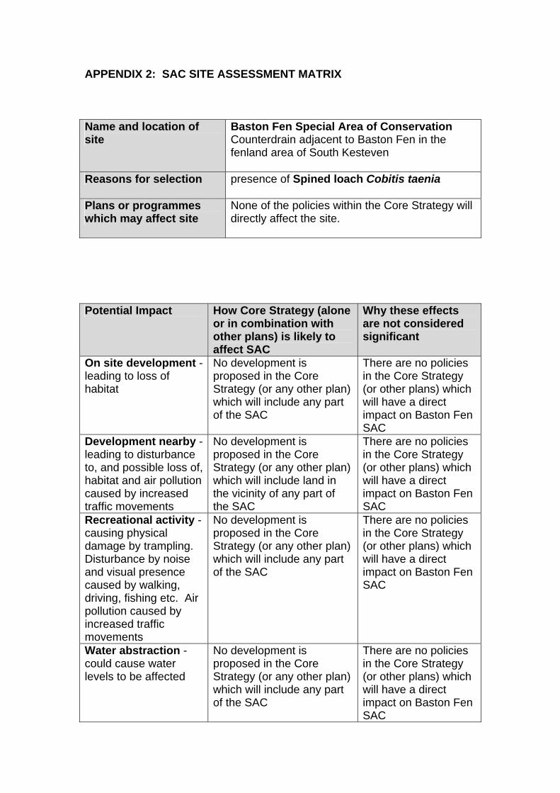
APPENDIX 2: SAC SITE ASSESSMENT MATRIX Name and location of site
Baston Fen Special Area of Conservation Counterdrain adjacent to Baston Fen in the fenland area of South Kesteven
Reasons for selection presence of Spined loach Cobitis taenia
Plans or programmes which may affect site
None of the policies within the Core Strategy will directly affect the site.
Potential Impact How Core Strategy (alone
or in combination with other plans) is likely to affect SAC
Why these effects are not considered significant
On site development - leading to loss of habitat
No development is proposed in the Core Strategy (or any other plan) which will include any part of the SAC
There are no policies in the Core Strategy (or other plans) which will have a direct impact on Baston Fen SAC
Development nearby - leading to disturbance to, and possible loss of, habitat and air pollution caused by increased traffic movements
No development is proposed in the Core Strategy (or any other plan) which will include land in the vicinity of any part of the SAC
There are no policies in the Core Strategy (or other plans) which will have a direct impact on Baston Fen SAC
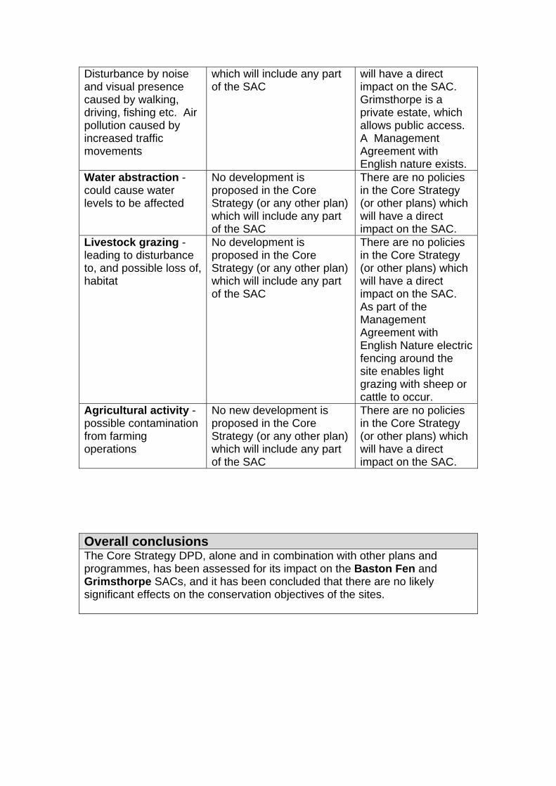
Recreational activity - causing physical damage by trampling. Disturbance by noise and visual presence caused by walking, driving, fishing etc. Air pollution caused by increased traffic movements
No development is proposed in the Core Strategy (or any other plan) which will include any part of the SAC
There are no policies in the Core Strategy (or other plans) which will have a direct impact on Baston Fen SAC
Water abstraction - could cause water levels to be affected
No development is proposed in the Core Strategy (or any other plan) which will include any part of the SAC
There are no policies in the Core Strategy (or other plans) which will have a direct impact on Baston Fen SAC
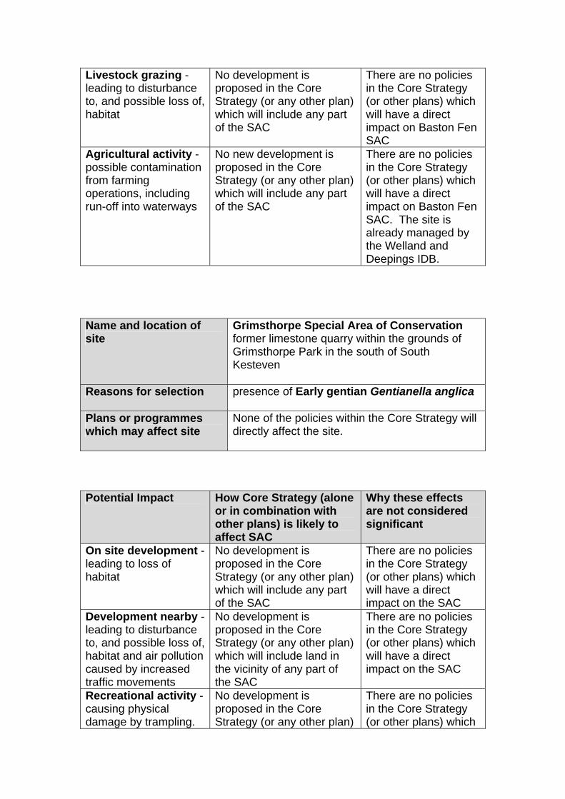
Livestock grazing - leading to disturbance to, and possible loss of, habitat
No development is proposed in the Core Strategy (or any other plan) which will include any part of the SAC
There are no policies in the Core Strategy (or other plans) which will have a direct impact on Baston Fen SAC
Agricultural activity - possible contamination from farming operations, including run-off into waterways
No new development is proposed in the Core Strategy (or any other plan) which will include any part of the SAC
There are no policies in the Core Strategy (or other plans) which will have a direct impact on Baston Fen SAC. The site is already managed by the Welland and Deepings IDB.
Name and location of site
Grimsthorpe Special Area of Conservation former limestone quarry within the grounds of Grimsthorpe Park in the south of South Kesteven
Reasons for selection presence of Early gentian Gentianella anglica
Plans or programmes which may affect site
None of the policies within the Core Strategy will directly affect the site.
Potential Impact How Core Strategy (alone
or in combination with other plans) is likely to affect SAC
Why these effects are not considered significant
On site development - leading to loss of habitat
No development is proposed in the Core Strategy (or any other plan) which will include any part of the SAC
There are no policies in the Core Strategy (or other plans) which will have a direct impact on the SAC
Development nearby - leading to disturbance to, and possible loss of, habitat and air pollution caused by increased traffic movements
No development is proposed in the Core Strategy (or any other plan) which will include land in the vicinity of any part of the SAC
There are no policies in the Core Strategy (or other plans) which will have a direct impact on the SAC
Recreational activity - causing physical damage by trampling.
No development is proposed in the Core Strategy (or any other plan)
There are no policies in the Core Strategy (or other plans) which
Disturbance by noise and visual presence caused by walking, driving, fishing etc. Air pollution caused by increased traffic movements
which will include any part of the SAC
will have a direct impact on the SAC. Grimsthorpe is a private estate, which allows public access. A Management Agreement with English nature exists.
Water abstraction - could cause water levels to be affected
No development is proposed in the Core Strategy (or any other plan) which will include any part of the SAC
There are no policies in the Core Strategy (or other plans) which will have a direct impact on the SAC.
Livestock grazing - leading to disturbance to, and possible loss of, habitat
No development is proposed in the Core Strategy (or any other plan) which will include any part of the SAC
There are no policies in the Core Strategy (or other plans) which will have a direct impact on the SAC. As part of the Management Agreement with English Nature electric fencing around the site enables light grazing with sheep or cattle to occur.
Agricultural activity - possible contamination from farming operations
No new development is proposed in the Core Strategy (or any other plan) which will include any part of the SAC
There are no policies in the Core Strategy (or other plans) which will have a direct impact on the SAC.
Overall conclusions The Core Strategy DPD, alone and in combination with other plans and programmes, has been assessed for its impact on the Baston Fen and Grimsthorpe SACs, and it has been concluded that there are no likely significant effects on the conservation objectives of the sites.
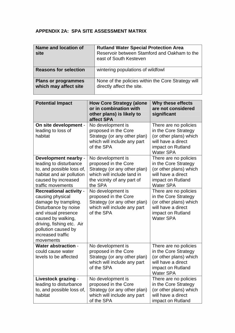
APPENDIX 2A: SPA SITE ASSESSMENT MATRIX Name and location of site
Rutland Water Special Protection Area Reservoir between Stamford and Oakham to the east of South Kesteven
Reasons for selection wintering populations of wildfowl
Plans or programmes which may affect site
None of the policies within the Core Strategy will directly affect the site.
Potential Impact How Core Strategy (alone
or in combination with other plans) is likely to affect SPA
Why these effects are not considered significant
On site development - leading to loss of habitat
No development is proposed in the Core Strategy (or any other plan) which will include any part of the SPA
There are no policies in the Core Strategy (or other plans) which will have a direct impact on Rutland Water SPA
Development nearby - leading to disturbance to, and possible loss of, habitat and air pollution caused by increased traffic movements
No development is proposed in the Core Strategy (or any other plan) which will include land in the vicinity of any part of the SPA
There are no policies in the Core Strategy (or other plans) which will have a direct impact on Rutland Water SPA
Recreational activity - causing physical damage by trampling. Disturbance by noise and visual presence caused by walking, driving, fishing etc. Air pollution caused by increased traffic movements
No development is proposed in the Core Strategy (or any other plan) which will include any part of the SPA
There are no policies in the Core Strategy (or other plans) which will have a direct impact on Rutland Water SPA
Water abstraction - could cause water levels to be affected
No development is proposed in the Core Strategy (or any other plan) which will include any part of the SPA
There are no policies in the Core Strategy (or other plans) which will have a direct impact on Rutland Water SPA
Livestock grazing - leading to disturbance to, and possible loss of, habitat
No development is proposed in the Core Strategy (or any other plan) which will include any part of the SPA
There are no policies in the Core Strategy (or other plans) which will have a direct impact on Rutland
Water SPA Agricultural activity - possible contamination from farming operations, including run-off into waterways
No new development is proposed in the Core Strategy (or any other plan) which will include any part of the SPA
There are no policies in the Core Strategy (or other plans) which will have a direct impact on Rutland Water SPA. The Nature Reserve is already managed in partnership with Anglian Water and the Leicestershire & Rutland Wildlife Trust.
Overall conclusion The Core Strategy DPD, alone and in combination with other plans and programmes, has been assessed for its impact on the Rutland Water SPA, and it has been concluded that there are no likely significant effects on the conservation objectives of the site. Name and location of site
Barnack Hill and Holes Special Area of Conservation Disused limestone quarry on the outskirts of Barnack
Reasons for selection semi-natural dry grasslands and scrubland facies: on calcareous substrate (important orchid site)
Plans or programmes which may affect site
None of the policies within the Core Strategy will directly affect the site.
Potential Impact How Core Strategy (alone
or in combination with other plans) is likely to affect SPA
Why these effects are not considered significant
On site development - leading to loss of habitat
No development is proposed in the Core Strategy (or any other plan) which will include any part of the SAC
There are no policies in the Core Strategy (or other plans) which will have a direct impact on Barnack Hills and Holes SAC
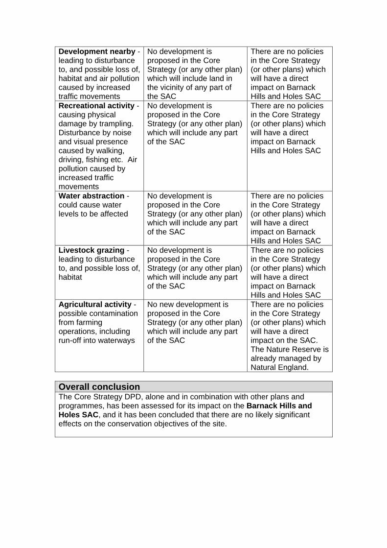
Development nearby - leading to disturbance to, and possible loss of, habitat and air pollution caused by increased traffic movements
No development is proposed in the Core Strategy (or any other plan) which will include land in the vicinity of any part of the SAC
There are no policies in the Core Strategy (or other plans) which will have a direct impact on Barnack Hills and Holes SAC
Recreational activity - causing physical damage by trampling. Disturbance by noise and visual presence caused by walking, driving, fishing etc. Air pollution caused by increased traffic movements
No development is proposed in the Core Strategy (or any other plan) which will include any part of the SAC
There are no policies in the Core Strategy (or other plans) which will have a direct impact on Barnack Hills and Holes SAC
Water abstraction - could cause water levels to be affected
No development is proposed in the Core Strategy (or any other plan) which will include any part of the SAC
There are no policies in the Core Strategy (or other plans) which will have a direct impact on Barnack Hills and Holes SAC
Livestock grazing - leading to disturbance to, and possible loss of, habitat
No development is proposed in the Core Strategy (or any other plan) which will include any part of the SAC
There are no policies in the Core Strategy (or other plans) which will have a direct impact on Barnack Hills and Holes SAC
Agricultural activity - possible contamination from farming operations, including run-off into waterways
No new development is proposed in the Core Strategy (or any other plan) which will include any part of the SAC
There are no policies in the Core Strategy (or other plans) which will have a direct impact on the SAC. The Nature Reserve is already managed by Natural England.
Overall conclusion The Core Strategy DPD, alone and in combination with other plans and programmes, has been assessed for its impact on the Barnack Hills and Holes SAC, and it has been concluded that there are no likely significant effects on the conservation objectives of the site.
APPENDIX 3: ASSESSMENT FRAMEWORK
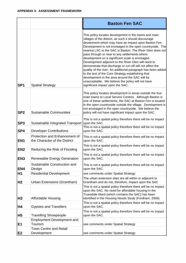
Baston Fen SAC
SP1 Spatial Strategy
This policy locates development in the towns and main villages of the district, as such it should discourage develoment which may have an impact upon Baston Fen. Development is not envisaged in the open countryside. The nearest LSC to the SAC is Baston. The River Glen does not pass through or near to any settlements where development on a significant scale is envisaged. Development adjacent to the River Glen will need to demonstrate that discharge or run-off will not affect the quality of the river. An additional paragraph has been added to the text of the Core Strategy establishing that development in the area around the SAC will be unacceptable. We believe the policy will not have significant impact upon the SAC.
SP2 Sustainable Communities
This policy locates development in areas outside the four main towns to Local Service Centres. Although Baston is one of these settlements, the SAC at Baston Fen is located in the open countryside outside the village. Development is not envisaged in the open countryside. We believe the policy will not have significant impact upon the SAC.
SP3 Sustainable Integrated TransportThis is not a spatial policy therefore there will be no impact upon the SAC.
SP4 Developer ContributionsThis is not a spatial policy therefore there will be no impact upon the SAC.
EN1Protection and Enhancement of the Character of the District
This is not a spatial policy therefore there will be no impact upon the SAC.
EN2 Reducing the Risk of FloodingThis is not a spatial policy therefore there will be no impact upon the SAC.
EN3 Renewable Energy GenerationThis is not a spatial policy therefore there will be no impact upon the SAC.
EN4Sustainable Construction and Design
This is not a spatial policy therefore there will be no impact upon the SAC.
H1 Residential Development see comments under Spatial Strategy
H2 Urban Extensions (Grantham)The urban extension sites are all within or adjacent to Grantham and do not, therefore, impact upon the SAC
H3 Affordable Housing
This is not a spatial policy therefore there will be no impact upon the SAC. No need for affordable housing in the Truesdale Ward (which contains the SAC) has been identified in the Housing Needs Study (Fordham, 2006).
H4 Gypsies and TravellersThis is not a spatial policy therefore there will be no impact upon the SAC.
H5 Travelling ShowpeopleThis is not a spatial policy therefore there will be no impact upon the SAC.
E1Employment Development and Tourism see comments under Spatial Strategy
E2Town Centre and Retail Development see comments under Spatial Strategy
APPENDIX 3: ASSESSMENT FRAMEWORK
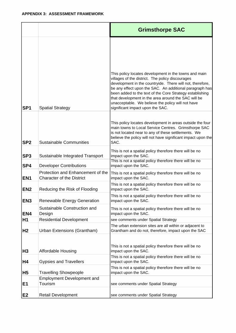
Grimsthorpe SAC
SP1 Spatial Strategy
This policy locates development in the towns and main villages of the district. The policy discourages development in the countryide. There will not, therefore, be any effect upon the SAC. An additional paragraph has been added to the text of the Core Strategy establishing that development in the area around the SAC will be unacceptable. We believe the policy will not have significant impact upon the SAC.
SP2 Sustainable Communities
This policy locates development in areas outside the four main towns to Local Service Centres. Grimsthorpe SAC is not located near to any of these settlements. We believe the policy will not have significant impact upon the SAC.
SP3 Sustainable Integrated TransportThis is not a spatial policy therefore there will be no impact upon the SAC.
SP4 Developer ContributionsThis is not a spatial policy therefore there will be no impact upon the SAC.
EN1Protection and Enhancement of the Character of the District
This is not a spatial policy therefore there will be no impact upon the SAC.
EN2 Reducing the Risk of FloodingThis is not a spatial policy therefore there will be no impact upon the SAC.
EN3 Renewable Energy GenerationThis is not a spatial policy therefore there will be no impact upon the SAC.
EN4Sustainable Construction and Design
This is not a spatial policy therefore there will be no impact upon the SAC.
H1 Residential Development see comments under Spatial Strategy
H2 Urban Extensions (Grantham)The urban extension sites are all within or adjacent to Grantham and do not, therefore, impact upon the SAC
H3 Affordable HousingThis is not a spatial policy therefore there will be no impact upon the SAC.
H4 Gypsies and TravellersThis is not a spatial policy therefore there will be no impact upon the SAC.
H5 Travelling ShowpeopleThis is not a spatial policy therefore there will be no impact upon the SAC.
E1Employment Development and Tourism see comments under Spatial Strategy
E2 Retail Development see comments under Spatial Strategy
APPENDIX 3: ASSESSMENT FRAMEWORK
Rutland Water SPA
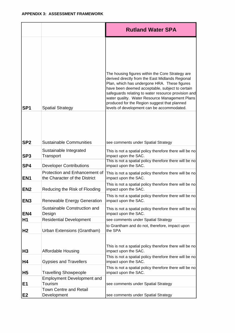
SP1 Spatial Strategy
The housing figures within the Core Strategy are derived directly from the East Midlands Regional Plan, which has undergone HRA. These figures have been deemed acceptable, subject to certain safeguards relating to water resource provision and water quality. Water Resource Management Plans produced for the Region suggest that planned levels of development can be accommodated.
SP2 Sustainable Communities see comments under Spatial Strategy
SP3Sustainable Integrated Transport
This is not a spatial policy therefore there will be no impact upon the SAC.
SP4 Developer ContributionsThis is not a spatial policy therefore there will be no impact upon the SAC.
EN1Protection and Enhancement of the Character of the District
This is not a spatial policy therefore there will be no impact upon the SAC.
EN2 Reducing the Risk of FloodingThis is not a spatial policy therefore there will be no impact upon the SAC.
EN3 Renewable Energy GenerationThis is not a spatial policy therefore there will be no impact upon the SAC.
EN4Sustainable Construction and Design
This is not a spatial policy therefore there will be no impact upon the SAC.
H1 Residential Development see comments under Spatial Strategy
H2 Urban Extensions (Grantham)to Grantham and do not, therefore, impact upon the SPA
H3 Affordable HousingThis is not a spatial policy therefore there will be no impact upon the SAC.
H4 Gypsies and TravellersThis is not a spatial policy therefore there will be no impact upon the SAC.
H5 Travelling ShowpeopleThis is not a spatial policy therefore there will be no impact upon the SAC.
E1Employment Development and Tourism see comments under Spatial Strategy
E2Town Centre and Retail Development see comments under Spatial Strategy
APPENDIX 3: ASSESSMENT FRAMEWORK
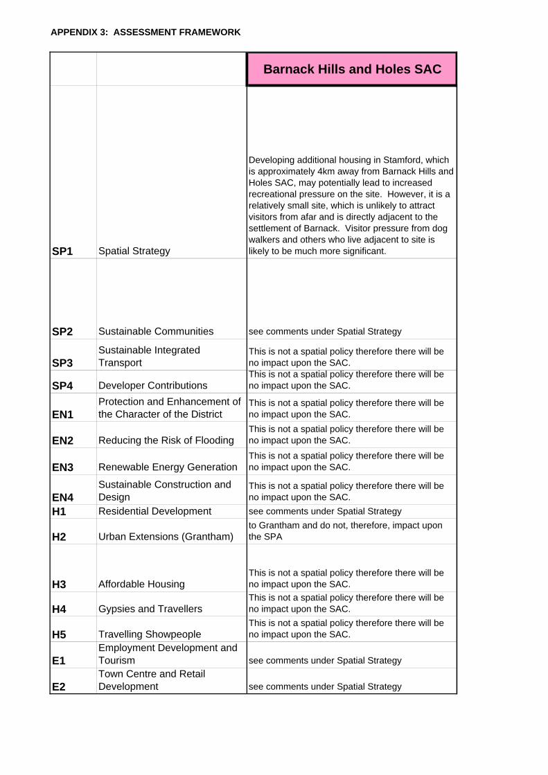
Barnack Hills and Holes SAC
SP1 Spatial Strategy
Developing additional housing in Stamford, which is approximately 4km away from Barnack Hills and Holes SAC, may potentially lead to increased recreational pressure on the site. However, it is a relatively small site, which is unlikely to attract visitors from afar and is directly adjacent to the settlement of Barnack. Visitor pressure from dog walkers and others who live adjacent to site is likely to be much more significant.
SP2 Sustainable Communities see comments under Spatial Strategy
SP3Sustainable Integrated Transport
This is not a spatial policy therefore there will be no impact upon the SAC.
SP4 Developer ContributionsThis is not a spatial policy therefore there will be no impact upon the SAC.
EN1Protection and Enhancement of the Character of the District
This is not a spatial policy therefore there will be no impact upon the SAC.
EN2 Reducing the Risk of FloodingThis is not a spatial policy therefore there will be no impact upon the SAC.
EN3 Renewable Energy GenerationThis is not a spatial policy therefore there will be no impact upon the SAC.
EN4Sustainable Construction and Design
This is not a spatial policy therefore there will be no impact upon the SAC.
H1 Residential Development see comments under Spatial Strategy
H2 Urban Extensions (Grantham)to Grantham and do not, therefore, impact upon the SPA
H3 Affordable HousingThis is not a spatial policy therefore there will be no impact upon the SAC.
H4 Gypsies and TravellersThis is not a spatial policy therefore there will be no impact upon the SAC.
H5 Travelling ShowpeopleThis is not a spatial policy therefore there will be no impact upon the SAC.
E1Employment Development and Tourism see comments under Spatial Strategy
E2Town Centre and Retail Development see comments under Spatial Strategy