guidelines: calibri 1. a. figure numbers: right click, add
TRANSCRIPT

Guidelines:
calibri
Task: size 14
1. Size 13 a. Size 12
Body: Size 11
Figure numbers: right click, add caption – figure number will be automatic
Discrepancies with pdf: maps 7a/b
PURPOSE
This existing conditions foundation report was produced by the New York City Mayor’s Office of Environmental Remediation (MOER) to assist citizens and community-based organizations (CBOs) to perform area-wide planning for revitalization of vacant and underutilized brownfield properties. Area-wide planning by citizens is supported by MOER under the NYC Place-Based Community Brownfield Planning Program and by the New York State Department of State in the Brownfield Opportunity Area Program. In addition to planning support, MOER provides financial and technical assistance to CBOs for cleanup and redevelopment of brownfield properties and seeks to help people foster greater health and well-being in their neighborhoods. Brownfields are vacant or under-utilized properties where environmental pollution has deterred investment and redevelopment. Pollution introduces many risks to land development and often causes community and private developers to pass over these properties, especially in low-income neighborhoods where land values may be depressed and insufficient to cover added cleanup costs. Over time, brownfield sites accumulate and cluster in these neighborhoods, presenting heightened health risks while also reducing opportunities for permanent new jobs and affordable housing. MOER has established a wide variety of programs to support place-based community brownfield planning and establish a local vision for use of these properties and to help bring community plans to life. Using these tools, we want to help citizens turn brownfield liabilities in their neighborhoods into community assets.
This existing conditions foundation report provides an overview of the study area’s geologic and natural features, historical development patterns, zoning, land use and infrastructure, as well as demographic and economic profiles. It lays out a summary of the environmental conditions and a preliminary selection of potential strategic properties for brownfield revitalization. It is intended to initiate an ongoing process of data collection and analysis to better inform community planning activities and visioning, as well as to enable citizens to make more informed decisions about their neighborhoods. This report was prepared by the New York City Department of City Planning under contract with the Mayor’s Office of Environmental Remediation.

TABLE OF CONTENTS Introduction .................................................................................................................................................. 1
Task I - Description of Proposed Project, Boundary and Public Participation .............................................. 2
1. Community Overview and History .................................................................................................... 2
a. Geographic location in relation to the county and region ............................................................ 2
b. Current community features and conditions ................................................................................ 2
Map 1: Broad Community Context Map - Queens, CD12, St. Albans neighborhood boundaries ........ 4
Map 2: Study Area Context Map - CD12, St. Albans neighborhood, Study Area Boundaries .............. 5
c. Demographic, social, economic, and employment indicators ...................................................... 6
Figure 1: Race/Hispanic Origin among residents in St. Albans and NYC .............................................. 6
Figure 2: Residential Age Distribution .................................................................................................. 7
Figure 3: Educational Attainment ......................................................................................................... 7
Figure 4: Percent of Employed Population by Industry ........................................................................ 8
Figure 5: Housing Tenure ...................................................................................................................... 9
Figure 6: Housing Occupancy ................................................................................................................ 9
d. Current and historical economic and land use development trends ........................................... 9
Figure 7: Land uses in Neighborhood ................................................................................................. 10
2. Project Overview and Description .................................................................................................. 11
a. Existing land uses and development patterns ............................................................................ 11
Map 3: Zoning and Land Use .............................................................................................................. 13
b. Summary of real or perceived brownfield sites and other abandoned, vacant, or partially developed sites located in the proposed PBCBPA .............................................................................. 14
c. An overview of the area's potential in terms of providing new development and uses, businesses and housing, creating new employment opportunities, generating additional revenues, new public amenities or recreational opportunities, and improving environmental quality ............ 14
3. PBCBPA Boundary Description and Justification ............................................................................ 16
Map 4: Brownfield Opportunity Area Boundary Map ........................................................................... 17
Task II - Preliminary Analysis of the Brownfield Opportunity Area ............................................................ 18
1. Existing Land Uses and Zoning ........................................................................................................ 18
Figure 8: Land Uses in Study Area .......................................................................................................... 19
Map 5: Zoning and Land Use .................................................................................................................. 21
2. Potential Brownfield, Abandoned and Vacant Sites ....................................................................... 22
Map 6: Brownfield and Underutilized Lots ............................................................................................ 23
3. Transportation and Infrastructure .................................................................................................. 27
4. Land Ownership .............................................................................................................................. 28
Figure 9: Property Ownership within Study Area .................................................................................. 29
5. Natural Resources ........................................................................................................................... 29
Map 7: Transportation and Infrastructure within Study Area ............................................................... 30
Map 8: Brownfields and Underutilied Lots ............................................................................................ 31
Map 9: City Trees and Open Space ........................................................................................................ 32
Summary of Preliminary Analysis and Recommendations ......................................................................... 33
Key Findings and Preliminary Recommendations ................................................................................... 33
Local Participation ................................................................................................................................... 34
APPENDIX A: SITE PROFILES ........................................................................................................................ 36
Site A: 114-05 Farmers Boulevard, Former Getty Gas Station ................................................................ 37
Site B: 113-50 Farmers Boulevard, “The Murdock Lot” .......................................................................... 39
Site 1: 109-35 Farmers Boulevard, Queen Esther’s Temple .................................................................... 41
Site 2: 109-43 Farmers Boulevard, St. Albans Early Childhood Center ................................................... 42
Site 3: 113-02, 113-04, 113-16 Farmers Boulevard, The “Triangle Building” ......................................... 44
APPENDIX B: ACCOMPANYING MAPS ......................................................................................................... 46
Map B-1: Brownfields and Underutilized Lots ........................................................................................ 47
Map B-2: Aerial Community Map ........................................................................................................... 48
Map B-3: Proposed BOA Boundary and Aerial Map ............................................................................... 49
Map B-4: Community Facilities ............................................................................................................... 50
Map B-5: Digital Elevation Model ........................................................................................................... 51
Map B-6: 2010 Census Tract Population ................................................................................................. 52
INTRODUCTION This existing conditions study for the Farmer Boulevard Corridor in Queens provides a foundation for place-based community planning for brownfield reuse.
The portion of Farmers Boulevard identified for study as part of this report is located between Brinkerhoff Avenue and Quencer road on the west side of Farmers Boulevard, and by 115th Road on the east side. It consists of a 0.7 mile expanse, starting approximately 3.5 miles northeast of JFK airport in the St. Albans neighborhood. While New York City and the borough of Queens have experienced significant economic development in recent years and over the past decade, there is substantial potential for further redevelopment of this portion of the Farmers Boulevard corridor.
The foundation study considers an area in need of contamination remediation and economic development or redevelopment. It provides an overview of existing land uses, development patterns, and real or perceived brownfield sites as well as development potential. Contextual information related to geographic location, demographic, social, economic and employment indicators, current community features and conditions, as well as current and historic economic and land use development trends help provide an understanding of the broader area surrounding the area of study.
This foundation report on existing conditions lays the basis for the future work by community groups to develop local visions for future brownfield development and implementation of those plans.
Existing Condition Foundation Report Place-Based Community Planning Farmers Boulevard, Queens
1 January 2015

TASK I Description of Proposed Project,
Boundary and Public Participation 1. Community Overview and History
a. Geographic location in relation to the county and region
The Farmers Boulevard corridor that is area of focus in this report is located within the St. Albans neighborhood in the southeast corner Queens County. Queens is the largest and second most populous borough of New York City with over 2.2 million people, about 27 percent of all New York City residents, at the 2010 Census. The borough is bounded to the east by Nassau County on Long Island, and by Kings County, or the borough of Brooklyn, NYC, to the southwest. The East River and the Atlantic Ocean form the borough’s north and south boundaries.
Queens is home to both of New York City’s major airports, John F. Kennedy and LaGuardia.
The neighborhood of St. Albans encompasses approximately 3 square miles in south eastern Queens, between Downtown Jamaica and Cambria Heights, and is in Queens Community District 12. For the purposes of this study, the neighborhood is roughly bounded by Henderson Avenue and 111 Avenue to the north, Springfield Boulevard to the southeast, Bedell Street to the southwest and Sayres Avenue to the northwest.
Residential development began in this area near the turn of the 20th century, and a post-World War I housing boom consequently established this area as a low density middle-income area. Through the 1940s, the neighborhood was home to several Jazz greats, including John Coltrane, Count Basie, and Ella Fitzgerald, and later evolved into a birthplace of hip hop and rap music. The neighborhood remains largely residential and low-scale, with detached single and two-family homes lining most streets.
Addisleigh Park, a residential enclave within St. Albans and west of the LIRR, was designated a Historic District in 2011 and shown on Map 2. The district encompasses over 400 homes largely constructed between 1910 and 1930. The area was originally developed as a white community, but a significant legal decision in 1948, Shelley vs. Kramer, ruled against restrictive covenants. Addisleigh Park then evolved into a community for many of the area’s upper-class black musicians.
b. Current community features and conditions
While there is no direct subway access to St. Albans, the West Hempstead branch of the Long Island Railroad has a station in St. Albans, which is located on Linden Boulevard near Farmers Boulevard, as well as several MTA busses connecting the neighborhood with the rest of the borough and city. Downtown Jamaica, just west of St. Albans, serves as a local transportation hub. The Jamaica Long Island Railroad station serves as a significant transfer point for trains between Long Island, Atlantic Terminal in Brooklyn, and Penn Station in Manhattan; ten of the LIRR’s eleven commuter trains pass through the Jamaica station. The E, F, J and Z MTA subway lines terminate in or near downtown
Existing Condition Foundation Report Place-Based Community Planning Farmers Boulevard, Queens
2 January 2015
Jamaica and are used by over 50,000 passengers daily. Over a dozen local and express busses connect Jamaica to St. Albans and the rest of the city. One spur of the JFK AirTrain connects Jamaica to JFK airport.
Jamaica also acts as a regional retail and employment hub. However, commercial uses are also found along Merrick Boulevard, Linden Boulevard, and Hollis Avenue. Along with Farmers Boulevard, these areas serve as the neighborhood’s local retail and transportation corridors. Commercial zoning along these corridors generally permits single-story local retail and personal service shops needed in residential neighborhoods, including grocery stores, nail salons, pharmacies and restaurants.
The nearby Roy Wilkins Park is the largest regional park and recreation center in southern Queens. The adjacent St. Albans Veterans Administration Hospital, shown on Map 2, is a significant institution in the neighborhood, which provides 386 beds, ambulatory care and inpatient extended care.
Today, several community groups serve the greater St. Albans area. The Farmers Boulevard CDC currently covers the portion of Farmers Boulevard between Hollis Avenue and Murdock Avenue, and the Neighborhood Housing Services of Jamaica has been active along the corridor. The African Center for Community Empowerment (acceusa.org) operates a community center in St. Albans.
The community context map provides a visual understanding of the neighborhood’s relationship to the surrounding area.
Existing Condition Foundation Report Place-Based Community Planning Farmers Boulevard, Queens
3 January 2015

Map 1: Broad Community Context Map - Queens, CD12, St. Albans neighborhood boundaries
Existing Condition Foundation Report Place-Based Community Planning Farmers Boulevard, Queens
4 January 2015

Map 2: Study Area Context Map - CD12, St. Albans neighborhood, Study Area Boundaries
Existing Condition Foundation Report Place-Based Community Planning Farmers Boulevard, Queens
5 January 2015

c. Demographic, social, economic, and employment indicators
Demographics
The neighborhood of St. Albans surrounds the portion of the Farmers Boulevard corridor included in this foundation study. The neighborhood at the 2010 Census, according to Figure 1, had a population of 48,593, down 2.9 percent from the 2000 Census population count of 50,046. Losses were counted among the White non-Hispanic and Black/African American non-Hispanic populations, while population gains were made most significantly among the Asian and Hispanic populations.
This loss contrasts with a 1.0 percent increase in the broader Community District 12 population between 2000 and 2010, and a 2.1 percent increase in population overall in New York City.
At 88.6 percent of the population, Black/African American remains the majority racial category in St. Albans. Black/African Americans make up approximately 22.8 percent of all residents in the city as a whole.
Figure 1
Race/Hispanic Origin among residents in St. Albans and NYC St. Albans NYC
Number Percent Number Percent
Total population 48,593 100.0% 8,175,133 100.0%
White non-Hispanic 469 1.0% 2,722,904 33.3%
Black/African American Nonhispanic 43,073 88.6% 1,861,295 22.8%
Asian Nonhispanic 417 0.9% 1,028,119 12.6%
Some other race Nonhispanic 403 0.8% 78,063 1.0%
Nonhispanic of two or more races 1,085 2.2% 148,676 1.8%
Hispanic origin 3,146 6.5% 2,336,076 28.6%
Source: Source: US Census Bureau, 2010 Census, SF1
Population Division - New York City Department of City Planning
According to Figure 2, the distribution of ages among residents of Queens CD12 skews younger, with a higher share of children to the total population in CD 12 than in Queens or the city as a whole. That said, there are roughly the same number of residents over the age of 65 (approximately 25,000) as there are under the age of 10 (approximately 28,000).
Existing Condition Foundation Report Place-Based Community Planning Farmers Boulevard, Queens
6 January 2015
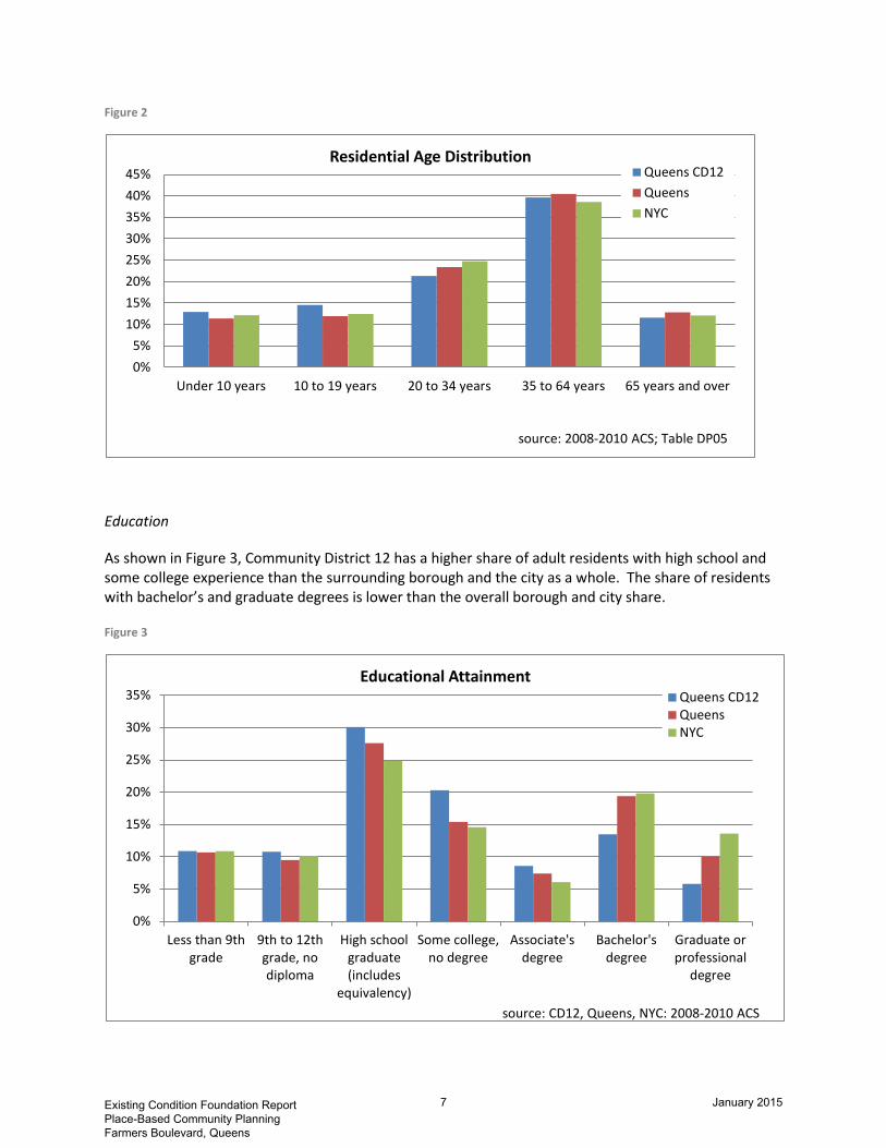
Figure 2
Education
As shown in Figure 3, Community District 12 has a higher share of adult residents with high school and some college experience than the surrounding borough and the city as a whole. The share of residents with bachelor’s and graduate degrees is lower than the overall borough and city share.
Figure 3
0%5%
10%15%20%25%30%35%40%45%
Under 10 years 10 to 19 years 20 to 34 years 35 to 64 years 65 years and over
Residential Age Distribution Queens CD12QueensNYC
source: 2008-2010 ACS; Table DP05
0%
5%
10%
15%
20%
25%
30%
35%
Less than 9thgrade
9th to 12thgrade, nodiploma
High schoolgraduate(includes
equivalency)
Some college,no degree
Associate'sdegree
Bachelor'sdegree
Graduate orprofessional
degree
Educational Attainment Queens CD12QueensNYC
source: CD12, Queens, NYC: 2008-2010 ACS
Existing Condition Foundation Report Place-Based Community Planning Farmers Boulevard, Queens
7 January 2015
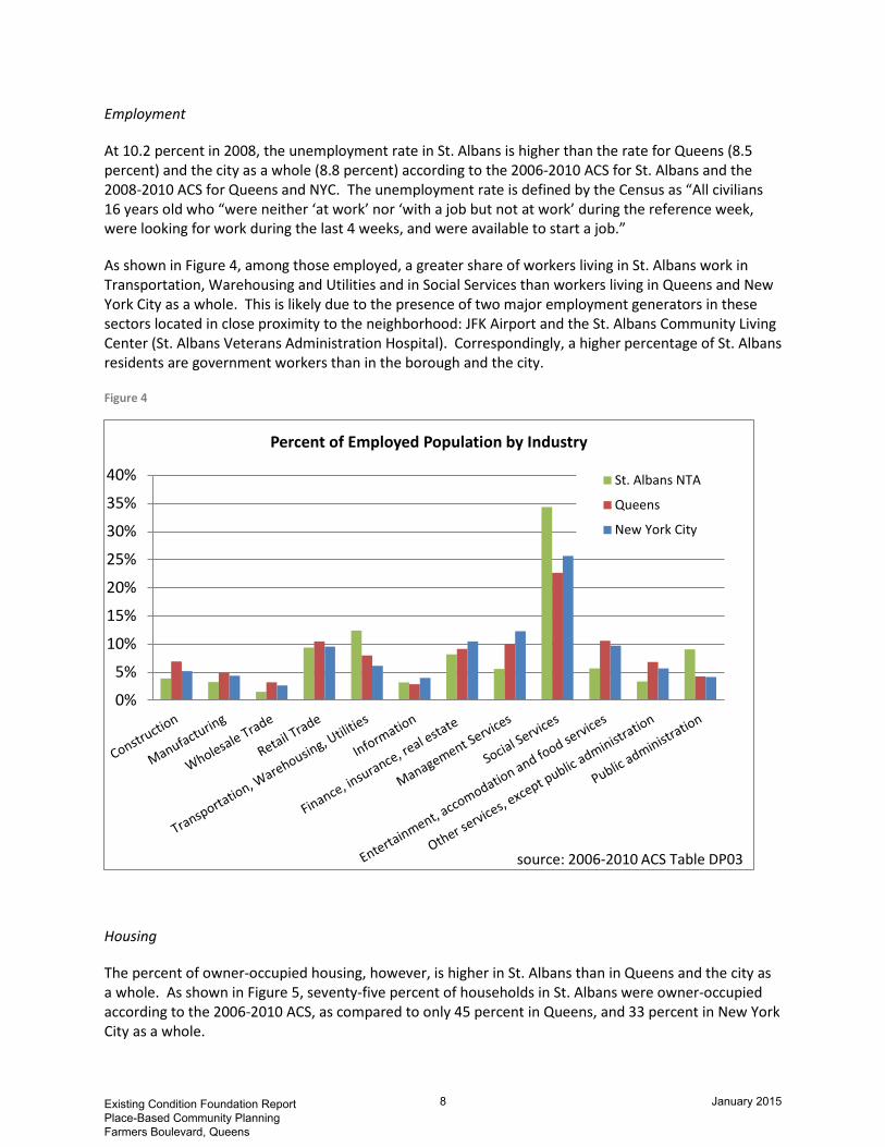
Employment
At 10.2 percent in 2008, the unemployment rate in St. Albans is higher than the rate for Queens (8.5 percent) and the city as a whole (8.8 percent) according to the 2006-2010 ACS for St. Albans and the 2008-2010 ACS for Queens and NYC. The unemployment rate is defined by the Census as “All civilians 16 years old who “were neither ‘at work’ nor ‘with a job but not at work’ during the reference week, were looking for work during the last 4 weeks, and were available to start a job.”
As shown in Figure 4, among those employed, a greater share of workers living in St. Albans work in Transportation, Warehousing and Utilities and in Social Services than workers living in Queens and New York City as a whole. This is likely due to the presence of two major employment generators in these sectors located in close proximity to the neighborhood: JFK Airport and the St. Albans Community Living Center (St. Albans Veterans Administration Hospital). Correspondingly, a higher percentage of St. Albans residents are government workers than in the borough and the city.
Figure 4
Housing
The percent of owner-occupied housing, however, is higher in St. Albans than in Queens and the city as a whole. As shown in Figure 5, seventy-five percent of households in St. Albans were owner-occupied according to the 2006-2010 ACS, as compared to only 45 percent in Queens, and 33 percent in New York City as a whole.
0%
5%
10%
15%
20%
25%
30%
35%
40%
Percent of Employed Population by Industry
St. Albans NTA
Queens
New York City
source: 2006-2010 ACS Table DP03
Existing Condition Foundation Report Place-Based Community Planning Farmers Boulevard, Queens
8 January 2015

Figure 5
The housing unit vacancy rate in St. Albans, as shown in Figure 6, remains only slightly higher than the vacancy rate for Queens, and lower than that for the city as a whole. However, Jamaica and the neighborhoods south and east of it, including St. Albans, have experienced higher rates of housing foreclosure than the citywide average. A 2009 map produced by the New York Times indicates between 5 and 10 percent of homes in St. Albans are in foreclosure (http://www.nytimes.com/interactive/2009/05/15/nyregion/0515-foreclose.html). A review of foreclosed homes listed on zillow.com on December 20, 2012 (http://www.zillow.com) revealed 26 homes in foreclosure in the site’s neighborhoods of Hollis and St. Albans which, combined, approximate the neighborhood boundaries for St. Albans as defined in this report.
Figure 6
d. Current and historical economic and land use development trends
In response to community concerns that development during peak development years had been inconsistent with neighborhood scale and character, in 2007 the Department of City Planning adopted a rezoning in order to preserve the area's predominnt lower-density character and ensure that future
75%
45% 33%
25%
55% 67%
0%
20%
40%
60%
80%
100%
St Albans Queens New York City
Housing Tenure
Renter-occupied Owner-occupied
source: St. Albans: 2006-2010 ACS; Queens & NYC: 2008-2010 ACS
7.4% 7.0% 8.9%
92.6% 93.0% 91.1%
0.0%10.0%20.0%30.0%40.0%50.0%60.0%70.0%80.0%90.0%
100.0%
St. Albans Queens New York City
Housing Occupancy
Occupied housingunitsVacant housingunits
source: St. Albans: 2006-2010 ACS; Queens & NYC: 2008-2010 ACS
Existing Condition Foundation Report Place-Based Community Planning Farmers Boulevard, Queens
9 January 2015

residential development would be consistent with its surrounding context. The rezoning also changed the existing commercial overlays along Farmers Boulevard within the Study Area from C1-2 and C2-2 to C1-3 and C2-3 zoning, reducing the overlay depth from 150 to 100 feet, and reducing the off-street parking requirement for new development.
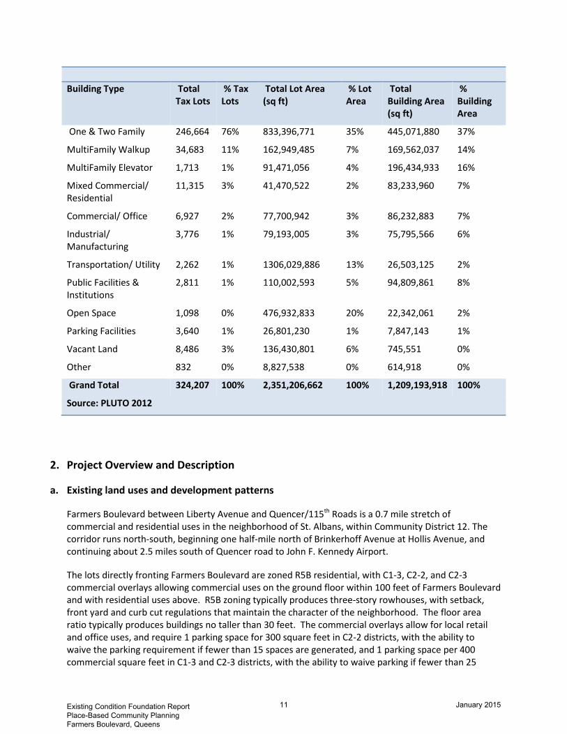
As shown in Figure 7a below, land uses within the St. Albans neighborhood are primarily residential, with over 90 percent of all lots and 77 percent of all building area occupied by one and two family homes. As previously discussed, a small number of commercial uses are in place to serve the neighborhood’s local retail needs. There is about one million square feet of vacant lot area within the neighborhood, representing 2 percent of all lot area in St. Albans.
Figure 7
Land Uses in the St. Albans Neighborhood Tabulation Area (NTA)
Building Type Total Tax Lots
% Tax Lots
Total Lot Area (sq ft)
% Lot Area
Total Building Area (sq ft)
% Building Area
One & Two Family 10,985 91% 37,534,346 71% 17,499,853 77%
MultiFamily Walkup 112 1% 1,010,447 2% 707,245 3%
MultiFamily Elevator 1 0% 9,645 0% 43,353 0%
Mixed Commercial/ Residential
259 2% 625,785 1% 656,485 3%
Commercial/ Office 124 1% 1,532,627 3% 764,893 3%
Industrial/ Manufacturing
37 0% 1,536,743 3% 776,939 3%
Transportation/ Utility 69 1% 1,330,372 3% 130,131 1%
Public Facilities & Institutions
90 1% 4,161,574 8% 1,897,574 8%
Open Space 15 0% 3,802,103 7% 55,212 0%
Parking Facilities 84 1% 574,375 1% 46,952 0%
Vacant Land 322 3% 1,049,455 2% 6,902 0%
Grand Total 12,098 100% 53,167,472 100% 22,585,539 100%
Source: PLUTO 2012
Existing Condition Foundation Report Place-Based Community Planning Farmers Boulevard, Queens
10 January 2015
Building Type Total
Tax Lots % Tax Lots
Total Lot Area (sq ft)
% Lot Area
Total Building Area (sq ft)
% Building Area
One & Two Family 246,664 76% 833,396,771 35% 445,071,880 37%
MultiFamily Walkup 34,683 11% 162,949,485 7% 169,562,037 14%
MultiFamily Elevator 1,713 1% 91,471,056 4% 196,434,933 16%
Mixed Commercial/ Residential
11,315 3% 41,470,522 2% 83,233,960 7%
Commercial/ Office 6,927 2% 77,700,942 3% 86,232,883 7%
Industrial/ Manufacturing
3,776 1% 79,193,005 3% 75,795,566 6%
Transportation/ Utility 2,262 1% 1306,029,886 13% 26,503,125 2%
Public Facilities & Institutions
2,811 1% 110,002,593 5% 94,809,861 8%
Open Space 1,098 0% 476,932,833 20% 22,342,061 2%
Parking Facilities 3,640 1% 26,801,230 1% 7,847,143 1%
Vacant Land 8,486 3% 136,430,801 6% 745,551 0%
Other 832 0% 8,827,538 0% 614,918 0%
Grand Total 324,207 100% 2,351,206,662 100% 1,209,193,918 100%
Source: PLUTO 2012
2. Project Overview and Description
a. Existing land uses and development patterns
Farmers Boulevard between Liberty Avenue and Quencer/115th Roads is a 0.7 mile stretch of commercial and residential uses in the neighborhood of St. Albans, within Community District 12. The corridor runs north-south, beginning one half-mile north of Brinkerhoff Avenue at Hollis Avenue, and continuing about 2.5 miles south of Quencer road to John F. Kennedy Airport.
The lots directly fronting Farmers Boulevard are zoned R5B residential, with C1-3, C2-2, and C2-3 commercial overlays allowing commercial uses on the ground floor within 100 feet of Farmers Boulevard and with residential uses above. R5B zoning typically produces three-story rowhouses, with setback, front yard and curb cut regulations that maintain the character of the neighborhood. The floor area ratio typically produces buildings no taller than 30 feet. The commercial overlays allow for local retail and office uses, and require 1 parking space for 300 square feet in C2-2 districts, with the ability to waive the parking requirement if fewer than 15 spaces are generated, and 1 parking space per 400 commercial square feet in C1-3 and C2-3 districts, with the ability to waive parking if fewer than 25
Existing Condition Foundation Report Place-Based Community Planning Farmers Boulevard, Queens
11 January 2015

spaces are generated. In the C2-2 districts, a development site of more than 4,500 square feet of commercial development would require parking; in the C1-3 and C2-3 districts, the development would need more than 10,000 square feet to require parking. Along Farmers Boulevard, most of the existing stores fall below the size threshold for a parking requirement.
While Farmers Boulevard is essentially a commercial street, several blocks that are zoned for commercial uses are occupied by residential or other uses. As a result, the corridor lacks the retail continuity of uninterrupted goods and services. Community groups have focused on economic and housing revitalizations, but the corridor struggles with higher vacancy rates and a lack of certain goods and services, including sit-down restaurants and pediatrician’s offices. Vacant commercial spaces, automotive uses and vacant land parcels contribute to the lack of retail continuity and make commercial success more difficult for new establishments by limiting pedestrian activity and lively sidewalks.
Farmers Boulevard curves through St. Albans, resulting in irregular lot sizes for those fronting the Boulevard, and traffic triangles that lead to wider street crossings and an interruption of any uses, commercial, residential or industrial.
The proposed Place-Based Community Brownfield Planning Area focuses on the portion of Farmers Boulevard most closely oriented towards active commercial uses, zoned largely for local retail and with minimal potential non-commercial uses that could interrupt the continuity.
Existing Condition Foundation Report Place-Based Community Planning Farmers Boulevard, Queens
12 January 2015

Map 3: Zoning and Land Use
Existing Condition Foundation Report Place-Based Community Planning Farmers Boulevard, Queens
13 January 2015

b. Summary of real or perceived brownfield sites and other abandoned, vacant, or partially developed sites located in the proposed PBCBPA
The land use analysis presented above reveals that 4 percent of all lots and 3 percent of total lot area along the Farmers Boulevard corridor study area are vacant. This is comparable to the amount of vacant land in the borough and citywide. However, in addition to vacant lots are those with structures that are underutilized, vacant, partially developed, or have contamination issues that hinder new development or the development of nearby properties.
Although the Farmers Boulevard corridor has a history of small-scale commercial uses, with warehousing and industrial uses located near the corridor, it has a short history of brownfield sites and noxious uses that affect development.
The New York State Department of Environmental Conservation maintains a Spill Record (Spill # 9610910) at 114-05 Farmers Boulevard http://www.dec.ny.gov/cfmx/extapps/derexternal/spills/details.cfm?pageid=2). On December 4th, 1996, a gasoline spill was reported at the Getty gasoline station, affecting the soil. The volume of the spill is not known (but a report produced by Toxics Targeting, Inc., in August 2008 states there is a minimal potential for fire or hazard (http://www.toxicstargeting.com/sites/default/files/sample_residential_report.pdf).
A second brownfield site is designated across the street at 113-50 Farmers Boulevard, which is currently an empty lot. The site was formerly a gas station and the Phase 1 report indicated that there was insufficient information to confirm whether the gas tanks from the former station were still underground or had been removed. Because of the spill history at 114-05 Farmers Boulevard across the street, OER has recommended the completion of a Phase 2 environmental assessment.
The high quantity of commercial vacancies and an additional number of storefront churches, closed during the work-week, contribute to a sense of blight and underutilization along the corridor.
c. An overview of the area's potential in terms of providing new development and uses, businesses and housing, creating new employment opportunities, generating additional revenues, new public amenities or recreational opportunities, and improving environmental quality
While poor environmental quality at some locations poses revitalization barriers, several vacant and underutilized tax lots along Farmers Boulevard provide potential for new development and uses and there are clear opportunities to improve the overall health of the corridor.
The Farmers Boulevard Community Development Corporation has a significant presence along the corridor, focused on commercial revitalization. The business development priorities they have identified include the attraction of dine-in restaurants, fresh produce and healthier take-out options, early childhood and education-oriented retail, and medical office space, along with additional art, music and cultural uses.
Additional analysis of the retail market potential along Farmers Boulevard was conducted using Claritas, a proprietary data provider. Claritas estimates potential annual consumer expenditures (demand) in various retail sectors sales using data from the Bureau of Labor Statistics and the Census of Retail Trade
Existing Condition Foundation Report Place-Based Community Planning Farmers Boulevard, Queens
14 January 2015

conducted by the US Census. Claritas also provides estimates of retail supply for custom geographies, derived from County Level business sales activity using wage and employment data from the Bureau of Labor Statistics’ ES-202 file and local sales tax data. More information on Claritas’ methodology can be found at http://tetrad.com/demographics/usa/nielsen/retailmarketpower.html.
The estimates for a custom geography’s retail supply and demand help to identify the potential for new business development and commercial uses. To understand commercial development potential along Farmers Boulevard, the area that falls within an approximate 10-minute drive time around the Farmers Boulevard BOA study area was drawn to capture a reasonable local retail trade area for the corridor. Shopping centers in Jamaica, Queens, and on Long Island are regional draws for significant shopping excursions. Downtown Jamaica has hundreds of small stores and larger anchors, including a multiplex movie theater. The Green Acres Mall on Long Island is only 5 miles from the corridor and also supplies hundreds of small and large stores.
Complementing these regional draws, Farmers Boulevard is suited as a local destination for daily errands and conveniences within the neighborhood. The low-scale architecture, street parking and bus access along Farmers Boulevard, surrounded by nearly 150,000 residents within a short walking and driving distance, bolsters the corridor’s potential to revitalize its local retail environment.
Claritas analysis identified a significant gap in retail spending versus retail supply, calculating over $1 billion in retail spending potential among residents within a 5 minute drive time of the corridor, yet less than $500 million in retail sales within the same geography. This represents an opportunity gap of over $650 million in retail sales in the neighborhood.
Retail supply and demand calculations provided by Claritas are likely weakened by the nature of urban economics, with significant shopping done regionally, but not necessarily within the neighborhood, given commute and other travel tendencies. The presence of large economic hubs in Jamaica and on Long Island, within a half-hours drive from the Farmers Boulevard corridor, likely draw significant expenditures just outside the neighborhood. Nevertheless, there is very clearly the spending potential within the neighborhood to support additional commercial options along Farmers Boulevard.
Looking more closely at appropriate additional commercial options, Claritas identified retail gaps in several sectors: food and beverage establishments including bars and restaurants, clothing stores, and sporting goods and hobby stores. The analysis does not consider gaps in non-retail services, like cultural centers or medical offices, but, as previously discussed, those uses were identified in discussion with the Farmers Boulevard CDC. Claritas also identified high spending on building material and garden equipment, and on automobiles and auto parts. This is reflective of the high owner-occupancy and car-ownership rates in St. Albans and southeastern Queens in particular, relative to the rest of the city. The Farmers Boulevard CDC Market Analysis corroborated the Claritas data, by finding: “The highest area of spending for residents within the study area is on home maintenance and operations which includes mortgage payments, remodeling expenses, utilities, and property taxes. The average household spent nearly $18,000 on such costs in 2009. The next highest expenses were on transportation which include vehicle purchases, maintenance and fuel costs.”
Over 40 percent of workers who live in Saint Albans commute more than an hour each way, and another 30 percent commute between 30 minutes and an hour each way, according to the 2006-2010 ACS. Approximately 46 percent of commuters drove alone to work, and nearly 42 percent took public transportation – split almost evenly between those taking the bus and those taking the subway as their primary mode.
Existing Condition Foundation Report Place-Based Community Planning Farmers Boulevard, Queens
15 January 2015

Given the travel patterns that most working residents follow during the workweek, the observed allocation of spending is to be expected. That said, bolstering the supply of goods and services that can be accessed conveniently close to home and in a pleasant neighborhood environment along Farmers Boulevard would appear be a win for both businesses and residents in Saint Albans.
3. PBCBPA Boundary Description and Justification
The proposed planning area boundaries along Farmers Boulevard align closely with the portion of the corridor that has been the primary focus of the Farmers Boulevard CDC. The boundaries also align with the commercial zoning overlay, since much of the study considers commercial and retail revitalization in the context of underutilized tax lots and ground contamination. The proposed area, bounded to the north by Brinkerhoff Avenue and to the south by Quencer Road and 115th Road, encompasses the portion of the corridor where substantial local energy is already focused and where there is capacity to channel more energy and efforts towards redevelopment.
The area would encompass approximately 21.63 acres and would affect existing commercial and residential uses, community facilities such as day care and medical offices, gas stations and vacant properties that may ultimately be built into any of the above. The boundaries would extend 100 feet from the sidewalk along Farmers Boulevard to encompass the commercial uses along Farmers Boulevard.
Existing Condition Foundation Report Place-Based Community Planning Farmers Boulevard, Queens
16 January 2015

Map 4: Brownfield Opportunity Area Boundary Map
Existing Condition Foundation Report Place-Based Community Planning Farmers Boulevard, Queens
17 January 2015

TASK II Preliminary Analysis of the PBCBPA
1. Existing Land Uses and Zoning
As discussed in Task I, Farmers Boulevard is a commercial corridor that runs through the neighborhood of Saint Albans, located in southeast Queens in Community District 12. The portion of the boulevard encompassed in the study area boundary runs from Brinkerhoff Avenue/ 109th Avenue to the north and Quencer Road/ 115th Road to the south. The area captures 160 tax lots fronting on Farmers Boulevard. These lots, plus other square footage associated with features including sidewalks and roadbeds, encompass a total of 21.63 acres. By comparison, the St. Albans neighborhood encompasses over 1700 acres.
Along the corridor, land uses are comprised primarily of ground floor commercial and 2nd, 3rd, and 4th story residential with some single family houses, automotive and gas stations, and vacant properties. The broader neighborhood is made composed of primarily of single family homes, with some warehousing and light industrial facilities along Dunkirk Street and the Long Island Railroad, about one-half mile west of Farmers Boulevard.
Within the study area boundaries, three of the 160 tax lots are city-owned; they are managed by the New York City Department of Housing Preservation and Development. Four of the lots are under mixed public and private ownership.
The lots directly fronting Farmers Boulevard are zoned R5B residential, with C1-3, C2-2, and C2-3 commercial overlays allowing commercial uses on the ground floor within 100 feet of Farmers Boulevard and with residential uses above. R5B zoning typically produces three-story rowhouses, with setback, front yard and curb cut regulations that maintain the character of the neighborhood. The floor area ratio typically produces buildings no taller than 30 feet. The commercial overlays allow for local retail and office uses, and require 1 parking space for 300 square feet in C2-2 districts, with the ability to waive the parking requirement if fewer than 15 spaces are generated, and 1 parking space per 400 commercial square feet in C1-3 and C2-3 districts, with the ability to waive parking if fewer than 25 spaces are generated. In the C2-2 districts, a development site of more than 4,500 square feet of commercial would require parking. In the C1-3 and C2-3 districts, the development would need more than 10,000 square feet to require parking. Along Farmers Boulevard, most of the existing stores fall below the size threshold for a parking requirement.
Data from the 2010 Quarterly Census of Employment and Wages (3rd Quarter), obtained from the New York State Department of Labor reinforce the impression that the corridor is dominated by small businesses. The data set is compiled from unemployment insurance records, and provides address-level information on the type of establishment and number of employees at that location. The data show an average of only 3 employees per establishment along the corridor. Because the data set relies on records of unemployment insurance paid by business owners for every tax-paying employee, it misses any employees accounted for by a primarily cash economy and some small businesses that often get by with the help of friends and family who may not be formally on the books. Nevertheless, an average of only 3 employees measured by unemployment insurance records is still a significant indicator of the general type of business and employment found along Farmers Boulevard. By comparison, Jamaica
Existing Condition Foundation Report Place-Based Community Planning Farmers Boulevard, Queens
18 January 2015
Avenue, a primary commercial corridor running through downtown Jamaica, averages over twice as many employees per establishment.
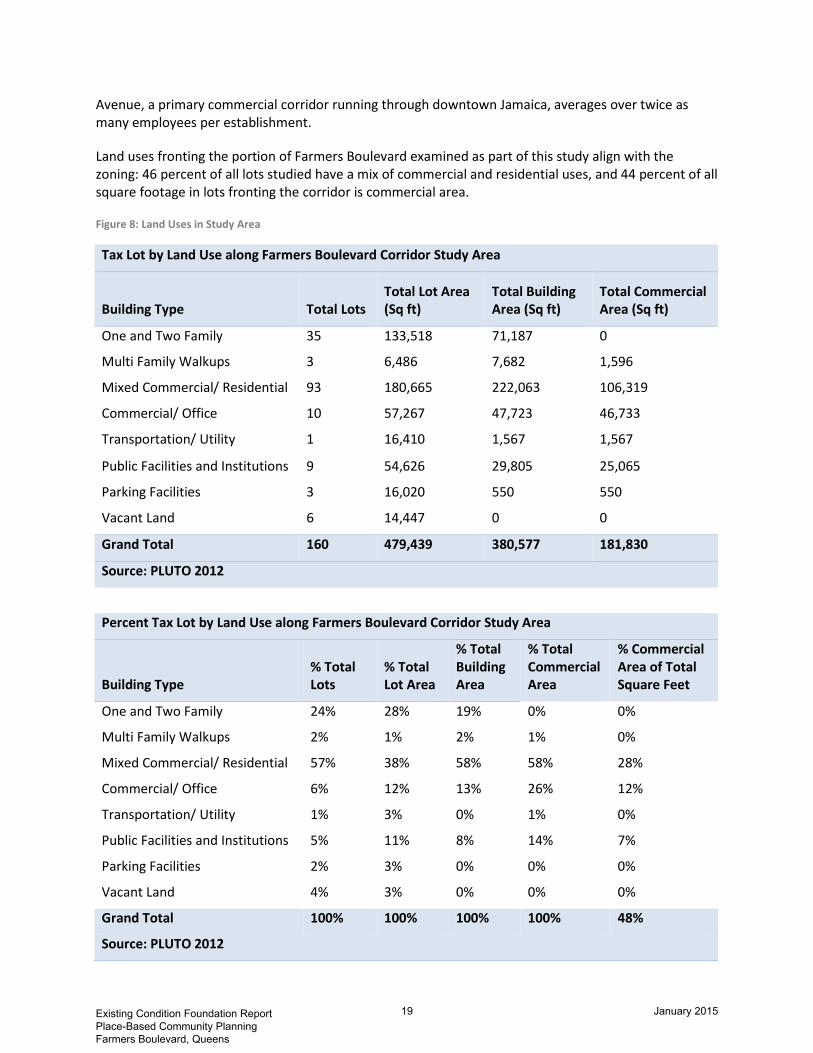
Land uses fronting the portion of Farmers Boulevard examined as part of this study align with the zoning: 46 percent of all lots studied have a mix of commercial and residential uses, and 44 percent of all square footage in lots fronting the corridor is commercial area.
Figure 8: Land Uses in Study Area
Tax Lot by Land Use along Farmers Boulevard Corridor Study Area
Building Type Total Lots Total Lot Area (Sq ft)
Total Building Area (Sq ft)
Total Commercial Area (Sq ft)
One and Two Family 35 133,518 71,187 0
Multi Family Walkups 3 6,486 7,682 1,596
Mixed Commercial/ Residential 93 180,665 222,063 106,319
Commercial/ Office 10 57,267 47,723 46,733
Transportation/ Utility 1 16,410 1,567 1,567
Public Facilities and Institutions 9 54,626 29,805 25,065
Parking Facilities 3 16,020 550 550
Vacant Land 6 14,447 0 0
Grand Total 160 479,439 380,577 181,830
Source: PLUTO 2012
Percent Tax Lot by Land Use along Farmers Boulevard Corridor Study Area
Building Type % Total Lots
% Total Lot Area
% Total Building Area
% Total Commercial Area
% Commercial Area of Total Square Feet
One and Two Family 24% 28% 19% 0% 0%
Multi Family Walkups 2% 1% 2% 1% 0%
Mixed Commercial/ Residential 57% 38% 58% 58% 28%
Commercial/ Office 6% 12% 13% 26% 12%
Transportation/ Utility 1% 3% 0% 1% 0%
Public Facilities and Institutions 5% 11% 8% 14% 7%
Parking Facilities 2% 3% 0% 0% 0%
Vacant Land 4% 3% 0% 0% 0%
Grand Total 100% 100% 100% 100% 48%
Source: PLUTO 2012
Existing Condition Foundation Report Place-Based Community Planning Farmers Boulevard, Queens
19 January 2015

As the tables above illustrate, 6 of the 160 tax lots are vacant, with no structure. One of these vacant lots, located at 114-65 Farmers Boulevard, is owned by HPD.
No portion of the study area along Farmers Boulevard has any local laws, development controls or incentive programs, including historic districts, NYC Industrial Business Zones, Business Improvement Zones or Empowerment Zones guiding land use, aside from the underlying zoning.
The zoning and land use map in this section shows the patterns of existing land uses as well as the location and type of existing zoning districts.
Existing Condition Foundation Report Place-Based Community Planning Farmers Boulevard, Queens
20 January 2015

Map 5: Zoning and Land Use
Existing Condition Foundation Report Place-Based Community Planning Farmers Boulevard, Queens
21 January 2015

Vacant and Underutilized Storefronts
An obvious weakness of the corridor is the high commercial vacancy rate. A retail market analysis conducted by the Farmers Boulevard Community Development Corporation in 2010 reports a vacancy rate around 16 percent and as high as 20 percent in their study area, which contains the area of Farmers Boulevard lying between 109th Street and Linden Boulevard (http://www.farmersblvd.org/sites/default/files/wysiwyg/Farmers_Blvd_Retail_Analysis_2010%5B1%5D%281%29.pdf ).
Field surveys conducted as part of this foundation study confirm a high prevailing commercial vacancy rate. Shuttered storefronts, underutilized window displays, run-down awnings and signage as well as littered sidewalks contribute to a perception of disinvestment and poor service and goods delivery. Vacant storefronts encourage loitering which further discourage pedestrian activity and patronage among the open stores along the corridor.
A disproportionately high share of street frontage is occupied by storefront churches. While small churches are positive resources within a community, they present challenges to commercial growth along Farmers Boulevard by disrupting the retail continuity. Their hours of operation peak on the weekend, leaving the appearance of closed or shuttered operations during normal weekday business hours. This foundation report does not suggest replacing the churches with other uses, but the quantity of the churches reinforces the need for the attraction of other, diverse commercial uses.
According to the Farmers Boulevard CDC, retail rents along the corridor within the study area range between $20 and $25 per square foot, or between $1600 and $2000 for a typical 1,000 square foot establishment.
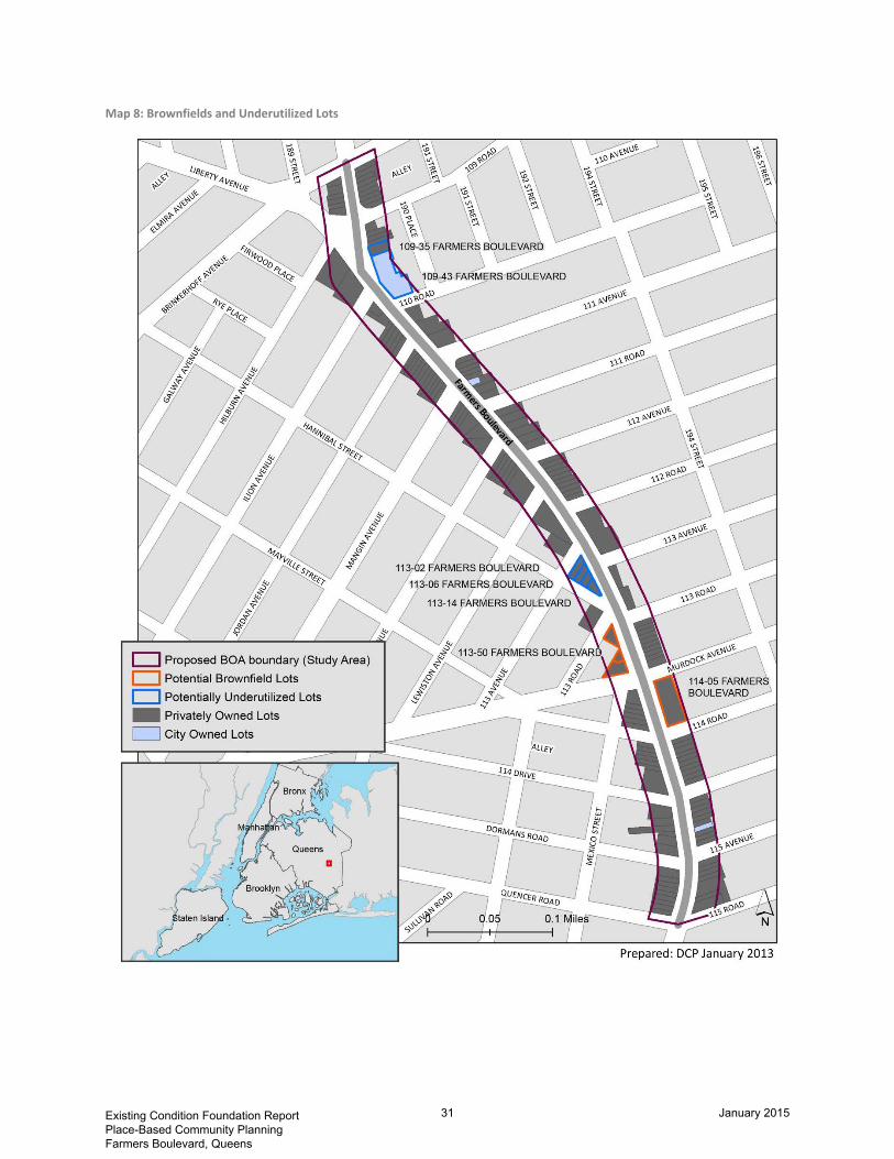
2. Potential Brownfield, Abandoned and Vacant Sites
Preliminary analysis of the proposed Farmers Boulevard BOA has identified two sites along the corridor as potential brownfield, abandoned, or vacant sites, shown on Map 6 below. Several others have been identified as underutilized. The underutilized sites do not likely suffer from contamination, but are in need of economic development attention.
The two potential brownfield sites include: 114-05 Farmers Boulevard, and 113-50 Farmers Boulevard. The underutilized sites include: 109-35 Farmers Boulevard, 109-43 Farmers Boulevard and 113-02 through 113-16 Farmers Boulevard, which will hereafter be referred to merely as 113-16 Farmers Boulevard.
The potential brownfield sites will be described below by letter. The underutilized sites will be profiled below by number. These properties are shown on the following map.
Potential Brownfield Sites A. 114-05 Farmers Boulevard B. 113-50 Farmers Boulevard
Underutilized Sites
1. 109-35 Farmers Boulevard 2. 109-43 Farmers Boulevard 3. 113-16 Farmers Boulevard
Existing Condition Foundation Report Place-Based Community Planning Farmers Boulevard, Queens
22 January 2015

Map 6: Brownfield and Underutilized Lots
Existing Condition Foundation Report Place-Based Community Planning Farmers Boulevard, Queens
23 January 2015

A. 114-05 Farmers Boulevard, Getty Gas Station
The Getty Gas Station is on a 16,410 square foot lot, with 200 feet of frontage along the east side of Farmers Boulevard and 82 feet of depth, between Murdock Avenue and 114 Road. The property is owned by Power Test Realty Co, and is zoned R5B with a C2-3 commercial overlay.
The NYC Department of Buildings Certificate of Occupancy records for the property identifies one dwelling on site in 1935. In 1944, the site was given a temporary certificate of occupancy for the “Sale of ice, coal and wood” for the duration of the war. In 1958, a Certificate of Occupancy was granted for a gasoline service station, and records indicate continuous use as such since then.
Directly across the street on Farmers Boulevard are a 2,300 square foot commercial lot and 5 residential rowhouses with 2 units in each, built as one development in 2004. On the blocks adjacent to the Getty Gas Station, commercial uses front Farmers Boulevard and residential uses front the side streets.
The New York State Department of Environmental Conservation maintains a Spill Record (Spill # 9610910) at 114-05 Farmers Boulevard (http://www.dec.ny.gov/cfmx/extapps/derexternal/spills/details.cfm?pageid=2). On December 4th, 1996, a gasoline spill was reported at the Getty gasoline station, affecting the soil. The volume of the spill is not known but a report produced by Toxics Targeting, Inc., in August 2008 states there is a minimal potential for fire or hazard (http://www.toxicstargeting.com/sites/default/files/sample_residential_report.pdf).
The site has been given an “E” designation by the NYC Office of Environmental Remediation due to its proximity to present and historic below-grade oil tanks. Redevelopment of the sites where contamination may be present could result in increased pathways of exposure to hazardous materials for future residents and construction workers. To avoid the potential for hazardous materials impacts, “E” designations (E-181) are mapped on development sites during a proposed zoning action. In this instance, the “E” designation was made as part of the St. Albans-Hollis Rezoning in 2007. On the lots where “E” designations were mapped, there is the potential for petroleum based contamination of soil and/or ground water from historic or current conditions and a potential for non-petroleum-based contamination.
In general, the “E” designation ensures that sampling and remediation take place where hazardous material contamination may exist. It required the fee owner to conduct a testing and sampling protocol and remediation (where appropriate) to the satisfaction of the NYCDEP before the issuance of a permit by the Department of Buildings pursuant to the provisions of Section 11-15 of the Zoning Resolution (Environmental Requirements). The “E” designation also includes a mandatory construction-related health and safety plan, which must also be approved by the NYCDEP.
Existing Condition Foundation Report Place-Based Community Planning Farmers Boulevard, Queens
24 January 2015
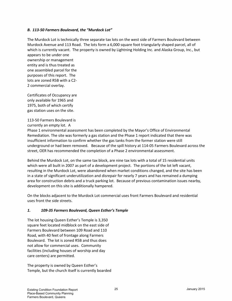
B. 113-50 Farmers Boulevard, the “Murdock Lot”
The Murdock Lot is technically three separate tax lots on the west side of Farmers Boulevard between Murdock Avenue and 113 Road. The lots form a 6,000 square foot triangularly shaped parcel, all of which is currently vacant. The property is owned by Lightning Holding Inc. and Alaska Group, Inc., but appears to be under one ownership or management entity and is thus treated as one assembled parcel for the purposes of this report. The lots are zoned R5B with a C2-2 commercial overlay.
Certificates of Occupancy are only available for 1965 and 1975, both of which certify gas station uses on the site.
113-50 Farmers Boulevard is currently an empty lot. A Phase 1 environmental assessment has been completed by the Mayor’s Office of Environmental Remediation. The site was formerly a gas station and the Phase 1 report indicated that there was insufficient information to confirm whether the gas tanks from the former station were still underground or had been removed. Because of the spill history at 114-05 Farmers Boulevard across the street, OER has recommended the completion of a Phase 2 environmental assessment.
Behind the Murdock Lot, on the same tax block, are nine tax lots with a total of 15 residential units which were all built in 2007 as part of a development project. The portions of the lot left vacant, resulting in the Murdock Lot, were abandoned when market conditions changed, and the site has been in a state of significant underutilization and disrepair for nearly 7 years and has remained a dumping area for construction debris and a truck parking lot. Because of previous contamination issues nearby, development on this site is additionally hampered.
On the blocks adjacent to the Murdock Lot commercial uses front Farmers Boulevard and residential uses front the side streets.
1. 109-35 Farmers Boulevard, Queen Esther’s Temple
The lot housing Queen Esther’s Temple is 3,350 square feet located midblock on the east side of Farmers Boulevard between 109 Road and 110 Road, with 40 feet of frontage along Farmers Boulevard. The lot is zoned R5B and thus does not allow for commercial uses. Community facilities (including houses of worship and day care centers) are permitted.
The property is owned by Queen Esther’s Temple, but the church itself is currently boarded
Existing Condition Foundation Report Place-Based Community Planning Farmers Boulevard, Queens
25 January 2015

up and has been vacant for over 15 years. According to the Farmers Boulevard CDC, the building was fraudulently mortgaged in 2004 and has been a regular site for loiterers, discouraging activity in the adjacent storefronts. Assemblyman Scarborough has requested an investigation into the fraudulent mortgage by the Attorney General, but no progress has been made to date. The Farmers Boulevard CDC envisions the site as an early childhood learning store to complement the surrounding school and day care population. There are no known contamination issues on the site.
The church sits next to a commercial use on to the north and a rambling, vacant, HPD-owned building to the south. It is across the street from the only neighborhood grocery store.
2. 109-43 Farmers Boulevard, St. Albans Early Childhood Center
The tax lot housing the St. Albans Early Childhood Center is an 18,500 square foot parcel with approximately 200 feet of frontage along Farmers Boulevard on the northeast corner with 110 Road. There are 5 buildings on the lot, attached by a series of corridors. The lot is zoned R5B and thus does not allow for commercial uses. Community facilities (including houses of worship and day care centers) are permitted.
The site has been given an “E” designation by the NYC Office of Environmental Remediation due to its proximity to present and historic below-grade oil tanks. Redevelopment of the sites where contamination may be present could result in increased pathways of exposure to hazardous materials for future residents and construction workers. To avoid the potential for hazardous materials impacts, “E” designations (E-181) are mapped on development sites a proposed zoning action. In this instance, the “E” designation was made as part of the St. Albans-Hollis Rezoning, in 2007. On the lots where “E” designations were mapped, there is the potential for petroleum-based contamination of soil and/or ground water from historic or current conditions and a potential for non-petroleum-based contamination.
The St. Albans Early Childhood Center occupies approximately 8,000 square feet of the series of buildings, while the remaining space is vacant. Certificates of Occupancy records show the property housed dwelling units from 1925 until it was converted to a nursing home in 1953. The most recent Certificate of Occupancy is from 1976, when it shows the use as a day care center with classrooms, offices and staff quarters. The Farmers Boulevard CDC confirms that the preschool has been in operation at this location for over 30 years. The school, which has capacity for over 100 children, is leasing the space from HPD.
HPD intends to dispose of the building via sale, and the preschool is organizing to purchase. The size and rambling nature of the buildings on the lot make upkeep and maintenance especially difficult. Old windows and an old, unified heating system that requires all buildings to be heated in order to heat the portions in active use results in considerable energy waste and expense. This, coupled with the requirements associated with redevelopment under an “E” designation, complicates the realization of the site’s full potential.
Existing Condition Foundation Report Place-Based Community Planning Farmers Boulevard, Queens
26 January 2015

3. 113-02, 113-06, 113-14 Farmers Boulevard, the “Triangle Building”
The Triangle Building is actually 4 separate, attached units on 4 tax lots, totaling 9,206 square feet and averaging 2,300 square feet each. The lots are zoned R5B with a C1-3 commercial overlay, and comprise the entire block along the west side of Farmers Boulevard between Hannibal Street and 113th Avenue. The Triangle Building spans all four lots and has over 15,000 square feet, plus additional basement square footage. The building is two stories tall and made of brick, with a pitched roof around the 2nd floor windows. The building stands out architecturally in the neighborhood of low-density commercial buildings and single-family homes.
The Triangle Building was built in 1938 and the first Certificate of Occupancy on record lists the use as “coal yard only.” The building was vacant for over 30 years when four separate owners bought portions of the building in an auction sale. Unable to collaborate on a redevelopment plan for the building, the Farmers Boulevard CDC helped to mediate an owner dispute and commence renovation in 2011. The CDC is currently recruiting a pediatrician and complementary uses at the triangular, southernmost end of the building, most of which is still vacant but is nearly completely renovated by its new owner.
3. Transportation and Infrastructure
The proposed Farmers Boulevard BOA boundary area encompasses a 0.7 mile stretch of Farmers Boulevard, a two lane street with parking and sidewalks on both sides. Contrary to its name, Farmers Boulevard is not actually a boulevard with a median. The street is about 50 feet wide from sidewalk to sidewalk.
While there is extensive subway access in Jamaica, Queens, just north of the project area, there is no direct subway service within the proposed BOA boundary. The Long Island railroad has the St. Albans station just south of the study area boundary. There is no direct air or water access within the study area; however, JFK airport is only a few miles to the south. Maps 1 and 2 at the beginning of this document highlight proximity to both JFK and the subway and rail network in Downtown Jamaica.
Within the study area boundaries, the Q3 and Q83 local busses and the X64 express bus run down Farmers Boulevard, as illustrated in Map 7. The Q3 travels from Jamaica to JFK airport; the Q83 travels from Jamaica to Cambria Heights, Queens; the X64, running on weekdays only, travels between Cambria Heights to Midtown Manhattan. It takes about 40 minutes from Farmers Boulevard to Midtown on the express bus.
Farmers Boulevard is designated a Queens Local Truck Route Network with no restrictions and is subject to NYC DOT traffic rules outlined in Section 4-13-(b)(2). The NYC DOT defines a local truck route network as “designated for trucks with an origin and destination within a borough. This includes trucks
Existing Condition Foundation Report Place-Based Community Planning Farmers Boulevard, Queens
27 January 2015

that are traveling to make a delivery, or for loading or servicing. Trucks should only use non-designated routes for the purpose at the beginning or end of a trip, when traveling between their origin/destination and a truck route” (http://www.nyc.gov/html/dot/html/motorist/truckrouting.shtml).
The study area is served by New York City’s sewer system. Farmers Boulevard is within the Jamaica sewage-shed, which treats and discharges sewage at the Jamaica Sewage Treatment Facility on Jamaica Bay and discharges sewage at the Jamaica Combined Sewer Outfall, also on Jamaica Bay. These facilities serve over 700,000 New York City residents living within the Jamaica sewage-shed (swimmablenyc.inf). The power supply within the study area is delivered by Con Edison.
4. Land Ownership
The majority of property within the Farmers Boulevard study area is privately owned, and houses of worship occupy a substantial portion of property along the corridor. The charts below show the breakdown of lot ownership by total number of lots and by total lot area.
As indicated in Map 8, of the lots identified as potential brownfield or underutilized sites, only the lot housing the St. Albans Early Childhood Center is currently under city ownership. Five of the six vacant lots within the boundary are privately owned; three comprise the Murdock Lot; two are adjacent to and under the same ownership as single-family homes. They appear to act as well-maintained yards for these homes. The sixth vacant lot is owned by HPD and is located mid-block between 115th Avenue and 114th Road.
Potential Brownfield Sites 114-05 Farmers Boulevard – Getty Gas Station: private ownership 113-50 Farmers Boulevard – Murdock Lot: private ownership Underutilized Sites 109-35 Farmers Boulevard – Esther’s Temple: private ownership 109-43 Farmers Boulevard – St. Albans Early Childhood Center: public ownership 113-16 Farmers Boulevard – Triangle Building: private ownership
Existing Condition Foundation Report Place-Based Community Planning Farmers Boulevard, Queens
28 January 2015

Figure 9: Property Ownership within Study Area
5. Natural Resources
The Farmers Boulevard corridor is generally flat, with no significant natural resources. There are no water sources, tributaries, wetlands, floodplains, erosion hazard areas, nor are there any major fish or wildlife habitats. The corridor has sidewalk trees and many trees are rooted in lot yards. A street median at the north end of the boundary area where Liberty Avenue meets Farmers Boulevard is designated as a New York City Greenstreet. Otherwise, there are no locally, state, or federally designated resources or open space areas within the proposed boundary area, as illustrated in Map 9.
2%
4%
94%
Property Ownership by Number of Lots
City ownership
Houses of Worship
Private Ownership (non HOW)
Source: PLUTO 2012
5% 7%
88%
Property Ownership by Total Lot Area
City ownership
Houses of Worship
Private Ownership (non HOW)
Source: PLUTO 2012
Existing Condition Foundation Report Place-Based Community Planning Farmers Boulevard, Queens
29 January 2015

Map 7: Transportation and Infrastructure within Study Area
Existing Condition Foundation Report Place-Based Community Planning Farmers Boulevard, Queens
30 January 2015
Map 8: Brownfields and Underutilized Lots
Existing Condition Foundation Report Place-Based Community Planning Farmers Boulevard, Queens
31 January 2015

Map 9: City Trees and Open Space
Existing Condition Foundation Report Place-Based Community Planning Farmers Boulevard, Queens
32 January 2015

TASK III Summary of Preliminary
Analysis and Recommendations Despite its route connecting two major transportation hubs in Queens, Downtown Jamaica and JFK Airport, Farmers Boulevard is essentially a local commercial corridor serving the quiet residential neighborhood of St. Albans. Its proximity to larger transportation and commercial centers offers access to employment generators and other resources offered by Queens and the broader metropolitan area, yet the neighborhood’s local strength is in its character and ability to provide a small-town, supportive environment nestled within one of the largest urban centers in the country.
This foundation study recognizes the potential for Farmers Boulevard to serve as a vibrant local retail corridor, conveniently serving goods and services to local residents. The study area would complement, not compete with, nearby and regional commercial hubs. The corridor’s proximity to nearly 150,000 residents and large daytime populations working at local schools and the hospital, as well as its connection to adjacent blocks with pedestrian-friendly sidewalks, make the Farmers Boulevard study area a natural candidate for commercial revitalization efforts.
Key Findings and Preliminary Recommendations
This study has identified two sites for potential brownfield remediation, and another three sites where attention might be targeted for commercial revitalization.
Building on the corridor’s strength as a pedestrian-friendly and locally-serving commercial spine through the residential neighborhood of St. Albans, one recommendation would be to target those commercial properties in a state of underutilization – either vacant land or unrented commercial buildings – for redevelopment. The restoration of the corridor’s commercial continuity is a critical first step in creating a welcoming local retail destination.
Revitalizing underutilized properties would be a next step in restoring the corridor’s perception as a valuable and healthy local corridor. Existing lots with little or no commercial activity attract other unproductive elements, including people who come to just hang out, consequently bringing down the attractiveness of adjacent uses. The corridor today is successful in providing local residents with certain necessary goods and services, including groceries and pharmacy items, but there is considerable room – both in local spending power and in square footage – for additional restaurants and other types of retail.
The neighborhood is populated by residents of all ages, and services designed to meet the needs of people at each stage of life are lacking. Early childhood and education oriented retail would support the roughly 28,000 children living and attending school in the neighborhood. Additional medical and support facilities would fill the present gap in services for older residents, as the first neighborhood pharmacy just recently moved to the neighborhood when Walgreens opened on Farmers Boulevard between 113th Road and 113th Avenue.
A sit-down restaurant could serve as a valuable anchor to the corridor. While several take-out options exist, there are few that allow customers to dine on site. Commercial spaces along the corridor are
Existing Condition Foundation Report Place-Based Community Planning Farmers Boulevard, Queens
33 January 2015

small, but not too small to preclude a café or other specialty establishment like those found along local retail corridors throughout the city.
With a large number of working households, a stable population and high homeownership rates, a bank would be an asset to the corridor, which currently has several ATMs but no full-service banks. A bank could fit easily into any of the smaller storefronts and, in addition to providing a valuable service, would signal the neighborhood as a place of stability and investment.
The Triangle Building
This development site presents one of the few opportunities for a larger commercial use within the proposed BOA boundaries. One building set across four tax lots, the ground floor alone has over 9,000 square feet of floor area zoned for commercial uses. The potential on this site is greatest for a sit-down restaurant or a medical or other community center. It’s proximity in the center of the proposed boundary makes it an ideal development opportunity for a significant neighborhood anchor.
The Murdock Lot
Also a large development site in the aggregate, the Murdock lot can accommodate up to 6,000 square feet of ground floor commercial uses. Its irregular shape and proximity to the residential units on the back side of the block make redevelopment tricky, but a quiet establishment with regular hours of operation would be ideal. High visibility due to its placement on the corner of the block make the site a good candidate for a bank with room for ATMs and banking services.
St. Albans Early Childhood Center
The 18,500 square foot HPD-owned lot that houses the St. Albans Early Childhood Center has great potential for a community facility. Lacking commercial zoning and given its city-ownership and current use on site, the lot is well-suited for additional educational facilities, a community center, and workforce training facilities. A major barrier to redevelopment currently is the environmental condition of the site and the general state of disrepair across the rambling series of loosely connected buildings.
Local Participation
As part of this study, outreach to the Farmers Boulevard Community Development Corporation (CDC) was made to better understand the local perception of economic development issues, as well as to gauge capacity for redevelopment within the community.
Already an active recipient of support from the NYC Department of Small Business Services (SBS), Queens Economic Development Corporation (QEDC), and Queens Council on the Arts, the Farmers Boulevard CDC has been working since 2009 to “revitalize Farmers Boulevard into an inspiring, convenient, and appropriately utilized main street serving St. Albans and the surrounding neighborhoods in southeast Queens, New York” (http://www.farmersblvd.org/about-us).
The Queens Economic Development Corporation has already demonstrated a commitment to assist the smaller Farmers Boulevard CDC, financially and with staff support. The mission of QEDC is to create and retain jobs through business development throughout Queens. In the summer of 2009, QEDC partnered with the Farmers Boulevard CDC to provide technical assistance to the CDC towards commercial revitalization, vacancy reduction, and physical infrastructure improvement. The groups also
Existing Condition Foundation Report Place-Based Community Planning Farmers Boulevard, Queens
34 January 2015

completed the Farmers Boulevard Retail Market Analysis in 2010, which has been cited throughout this report.
The Farmers Boulevard CDC, working with SBS and QEDC, has extensive ties to the community and relationships with several small business owners and community groups. They effectively conduct outreach sessions and have proven themselves able to identify problem areas within the community and manage strategies for problem solving. They are eager for additional resources to help them meet their goals.
Existing Condition Foundation Report Place-Based Community Planning Farmers Boulevard, Queens
35 January 2015

APPENDIX A: SITE PROFILES Descriptive Profile of Brownfield
and Underutilized Properties
Existing Condition Foundation Report Place-Based Community Planning Farmers Boulevard, Queens
36 January 2015

Site A: 114-05 Farmers Boulevard, Former Getty Gas Station
Property Description and Current Land Use
Site Name Former Getty Gas Station
Label A
Address 114-05 Farmers Blvd
Map Location 73°45'42.912"W 40°41'51.559"N
BBL 4110070005
Borough Queens
Owner Power Test Realty, Co
Publicly Owned No
Lot Size .38 acres (16,410 sqft)
Building Area 1,567sqft
Existing Buildings 1
Zoning R5B with C2-3 Overlay
Built FAR .01
Allowable FAR 1.35
Former Use Gas Station
Current Use Vacant
Adjacent Uses Commercial on Farmers Blvd. and Residential on side streets
Existing Condition Foundation Report Place-Based Community Planning Farmers Boulevard, Queens
37 January 2015
Environmental and Land Use History
The NYC Department of Buildings Certificate of Occupancy records for the property identifies one dwelling on site in 1935. In 1944, the site was given a temporary certificate of occupancy for the “Sale of ice, coal and wood” for the duration of the war. In 1958, a Certificate of Occupancy was granted for a gasoline service station and records indicate continuous use as such since then.
Environmental Regulatory Review Record Status
New York State Department of Environmental Conservation
Spill Record #9610910
On December 4th, 1996, a gasoline spill was reported at the Getty gasoline station, affecting the soil. The volume of the spill is not known but a report produced by Toxics Targeting, Inc., in August 2008 states there is a minimal potential for fire or hazard.
New York City Office of Environmental Remediation
“E” Designation “E” designation was made as part of the St. Albans-Hollis Rezoning, in 2007 signifying that there is potential for petroleum-based contamination of soil and/or ground water from historic or current conditions and a potential for non-petroleum-based contamination.
Existing Condition Foundation Report Place-Based Community Planning Farmers Boulevard, Queens
38 January 2015

Site B: 113-50 Farmers Boulevard, “The Murdock Lot”
Property Description and Current Land Use
Site Name “The Murdock Lot”
Label B
Address 113-50 Famers Blvd
Map Location (s) 73°45'45.671"W 40°41'53.318"N
73°45'45.565"W 40°41'53.696"N
73°45'45.945"W 40°41'54.424"N
BBL (s) 4104310019
4104310015
4104310010
Borough Queens
Owner Lightning Holding, Inc.
Publicly Owned No
Lot Size .14 acres (6,000sqft)
Building Area 0
Existing Buildings 0
Zoning R5B with C2-2 overlay
Built FAR 0
Allowable FAR 1.35
Former Use Gas Station
Current Use Vacant
Adjacent Uses Residential
Existing Condition Foundation Report Place-Based Community Planning Farmers Boulevard, Queens
39 January 2015

Environmental and Land Use History
Certificates of Occupancy are only available for 1965 and 1975, both of which certify gas station uses on the site. Behind the Murdock Lot, on the same tax block, are nine tax lots with a total of 15 residential units which were all built in 2007 as part of a development project. The portions of the lot left vacant, resulting in the Murdock Lot, were abandoned when market conditions changed, and the site has been in a state of significant underutilization and disrepair for nearly 7 years and has remained construction debris dumping area and a truck parking lot. Because of previous contamination issues nearby, development on this site is additionally hampered.
Environmental Regulatory Review Record Status
New York City Office of Environmental Remediation
Completed Phase 1 Environmental Assessment
The site was formerly a gas station and the Phase 1 report indicated that there was insufficient information to confirm whether the gas tanks from the former station were still underground or had been removed. Because of the spill history at 114-05 Farmers Boulevard across the street, OER has recommended the completion of a Phase 2 environmental assessment.
Existing Condition Foundation Report Place-Based Community Planning Farmers Boulevard, Queens
40 January 2015
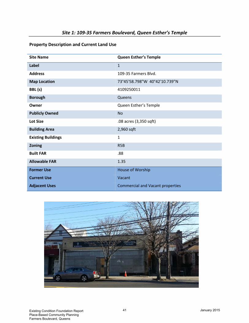
Site 1: 109-35 Farmers Boulevard, Queen Esther’s Temple
Property Description and Current Land Use
Site Name Queen Esther’s Temple
Label 1
Address 109-35 Farmers Blvd.
Map Location 73°45'58.798"W 40°42'10.739"N
BBL (s) 4109250011
Borough Queens
Owner Queen Esther’s Temple
Publicly Owned No
Lot Size .08 acres (3,350 sqft)
Building Area 2,960 sqft
Existing Buildings 1
Zoning R5B
Built FAR .88
Allowable FAR 1.35
Former Use House of Worship
Current Use Vacant
Adjacent Uses Commercial and Vacant properties
Existing Condition Foundation Report Place-Based Community Planning Farmers Boulevard, Queens
41 January 2015

Site 2: 109-43 Farmers Boulevard, St. Albans Early Childhood Center
Property Description and Current Land Use
Site Name St. Albans Early Childhood Center
Label 2
Address 109-43 Famers Blvd
Map Location (s) 73°45'57.45"W 40°42'9.231"N
BBL (s) 4109250001
Borough Queens
Owner Department of Housing Preservation and Development
Publicly Owned Yes
Lot Size .42 acres (18,500 sqft)
Building Area 9,353 sqft
Existing Buildings 5
Zoning R5B
Built FAR .51
Allowable FAR 1.35
Former Use Day Care Center
Current Use School
Adjacent Uses Residential and Vacant properties
Existing Condition Foundation Report Place-Based Community Planning Farmers Boulevard, Queens
42 January 2015

Environmental and Land Use History
Certificates of Occupancy records show the property housed dwelling units from 1925 until it was converted to a nursing home in 1953. The most recent Certificate of Occupancy is from 1976, when it shows the use as a day care center with classrooms, offices and staff quarters. The Farmers Boulevard CDC confirms that the preschool has been in operation at this location for over 30 years. The school, which has capacity for over 100 children, is leasing the space from HPD.
Environmental Regulatory Review Record Status
New York City Office of Environmental Remediation
“E” Designation The site has been given an “E” designation by the NYC Office of Environmental Remediation due to its proximity to present and historic below-grade oil tanks. “E” designation was made as part of the St. Albans-Hollis Rezoning in 2007. On the lots where “E” designations were mapped, there is the potential for petroleum-based contamination of soil and/or ground water from historic or current conditions and a potential for non-petroleum-based contamination
Existing Condition Foundation Report Place-Based Community Planning Farmers Boulevard, Queens
43 January 2015

Site 3: 113-02, 113-04, 113-16 Farmers Boulevard, The “Triangle Building”
Property Description and Current Land Use
Site Name The “Triangle Building”
Label 3
Address 113-02 – 113-16 Famers Blvd
Map Location (s) 73°45'47.754"W 40°41'57.555"N
73°45'47.417"W 40°41'57.323"N
73°45'47.334"W 40°41'56.911"N
73°45'46.912"W 40°41'56.562"N
BBL (s) 4104420029
4104420027
4104420025
4104420021
Borough Queens
Owner Lois Harris
Trina Harris-Hoy
John Miller
Locksley Richards
Publicly Owned No
Lot Size .23 acres (10,211 sqft)
Building Area 15,532 sqft
Existing Buildings 4
Zoning R5B with C1-3 overlay
Built FAR 2
1.99
1.61
1.18
Allowable FAR 1.35
Former Use Coal Yard
Current Use Vacant
Adjacent Uses N/A
Existing Condition Foundation Report Place-Based Community Planning Farmers Boulevard, Queens
44 January 2015

Environmental and Land Use History
The Triangle Building was built in 1938 and the first Certificate of Occupancy on record lists the use as “coal yard only.” The building was vacant for over 30 years when four separate owners bought portions of the building in an auction sale. Unable to collaborate on a redevelopment plan for the building, the Farmers Boulevard CDC helped to mediate an owner dispute and commence renovation in 2011. The CDC is currently recruiting a pediatrician and complementary uses at the triangular, southernmost end of the building, most of which is still vacant but nearly completely renovated by its new owner.
Existing Condition Foundation Report Place-Based Community Planning Farmers Boulevard, Queens
45 January 2015

APPENDIX B: ACCOMPANYING MAPS
Existing Condition Foundation Report Place-Based Community Planning Farmers Boulevard, Queens
46 January 2015

Map B-1: Brownfields and Underutilized Lots
Existing Condition Foundation Report Place-Based Community Planning Farmers Boulevard, Queens
47 January 2015

Map B-2: Aerial Community Map
Existing Condition Foundation Report Place-Based Community Planning Farmers Boulevard, Queens
48 January 2015

Map B-3: Proposed BOA Boundary and Aerial Map
Existing Condition Foundation Report Place-Based Community Planning Farmers Boulevard, Queens
49 January 2015

Map B-4: Community Facilities
Existing Condition Foundation Report Place-Based Community Planning Farmers Boulevard, Queens
50 January 2015

Map B-5: Digital Elevation Model
Existing Condition Foundation Report Place-Based Community Planning Farmers Boulevard, Queens
51 January 2015

Map B-6: 2010 Census Tract Population
Existing Condition Foundation Report Place-Based Community Planning Farmers Boulevard, Queens
52 January 2015