guide to lot line or easement adjustments · submittal continued 2 ; search for planning services...
TRANSCRIPT
N W
OO
DH
AVE
N D
R
Woodhaven_Map
0 110 220
Feet
LegendMajor RoadsOther Roads
RailroadsParcels
Municipalities
n Schools
-DISCLAIMERAll data and in formation ("Products") conta ined here inare for in formational purposes only. Al though s uch Products are bel ieved to be acc urate at the time of publication, Douglas County does not warrant that such Products are er ror free. Douglas County provides these Products on an " as is" bas is wi thout warr anties of any kind, ei ther express or im pl ied, including, but not lim itedto, warranties of title or impl ied warranties of merc hantabil ityor fi tness for a particu lar purpose. Douglas County shallnot be liable for any di rect,indi rect, inc identa l, specia l or consequential damages arising out of the use of such Products, or the inabili ty to use s uch Products or out o f any breach of any warranty. The user acknowledges and agreesthat the use of suc h Produc ts is a t the sole risk o f the user. General questions about th is or any other Douglas County GIS produc ts,includ ing errors, omis sions, corrections and/or updates should be di rected to the Douglas County GIS Division at (303) 660-7416.
Guide to Lot Line or Easement Adjustments
In this packetWho Needs This Packet.....................1
Step-by-Step Guide and Fees...........2-4
Sample Exhibits...........................5-6
Sample Approval Certificate..............7
Department of Community Development100 Third St. | Castle Rock, CO 80104 | Ph: 303-660-7460 | www.douglas.co.us
Step 1
Step 2
Step 3
Step 4
Step 5
Step 6
Presubmittal Review
Submittal
Pre-Referral Review
Applicant Revision
Prepare the Approval Certificate
Referral Period and Courtesy Notification
Step 7Post Referral Review
Step 8Applicant Revision
and Response
Step 9Approval
Step 10Recordation
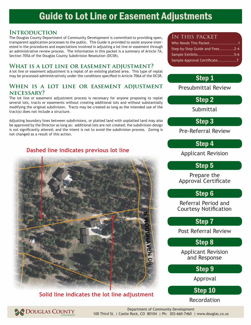
Dashed line indicates previous lot line
Solid line indicates the lot line adjustment
IntroductionThe Douglas County Department of Community Development is committed to providing open, transparent application processes to the public. This Guide is provided to assist anyone inter-ested in the procedures and expectations involved in adjusting a lot line or easement through an administrative review process. The information in this packet is a summary of Article 7A, Section 705A of the Douglas County Subdivision Resolution (DCSR).
What is a lot line or easement adjustment?A lot line or easement adjustment is a replat of an existing platted area. This type of replat may be processed administratively under the conditions specified in Article 706A of the DCSR.
When is a lot line or easement adjustment necessary?The lot line or easement adjustment process is necessary for anyone proposing to replat several lots, tracts or easements without creating additional lots and without substantially modifying the original subdivision. Tracts may be created as long as the intended use of the tract(s) does not include a structure.
Adjusting boundary lines between subdivisions, or platted land with unplatted land may also be approved by the Director as long as: additional lots are not created; the subdivision design is not significantly altered; and the intent is not to avoid the subdivision process. Zoning is not changed as a result of this action.

Steps 1-3 of the Lot Line or Easement Adjustment Process
County Staff’s Goal for Completion: 7 daysThe presubmittal review is the initial review of a proposal to identify potentially significant issues and submittal require-ments. While Planning Services staff strives to identify critical issues at presubmittal, additional issues may be identified during the formal application review and referral process.
A streamlined presubmittal review process is available for an administrative lot line or easement adjustment. The appli-cant may request a presubmittal review by calling 303-660-7460. The proposal will be discussed among staff once received. Written comments from the presubmittal review are typically provided to the applicant within two days. Presubmittal comments are valid for one year from the date of the presubmittal review.
Department of Community Development
Presubmittal Review
1
2
Submittal
County Staff’s Goal for Completion: 2 daysFollowing the presubmittal review, the applicant may submit a formal application to Planning Services. A planning techni-cian reviews the application submittal to ensure that all required items have been included. Once all materials are pro-vided, a planner is assigned to the project.
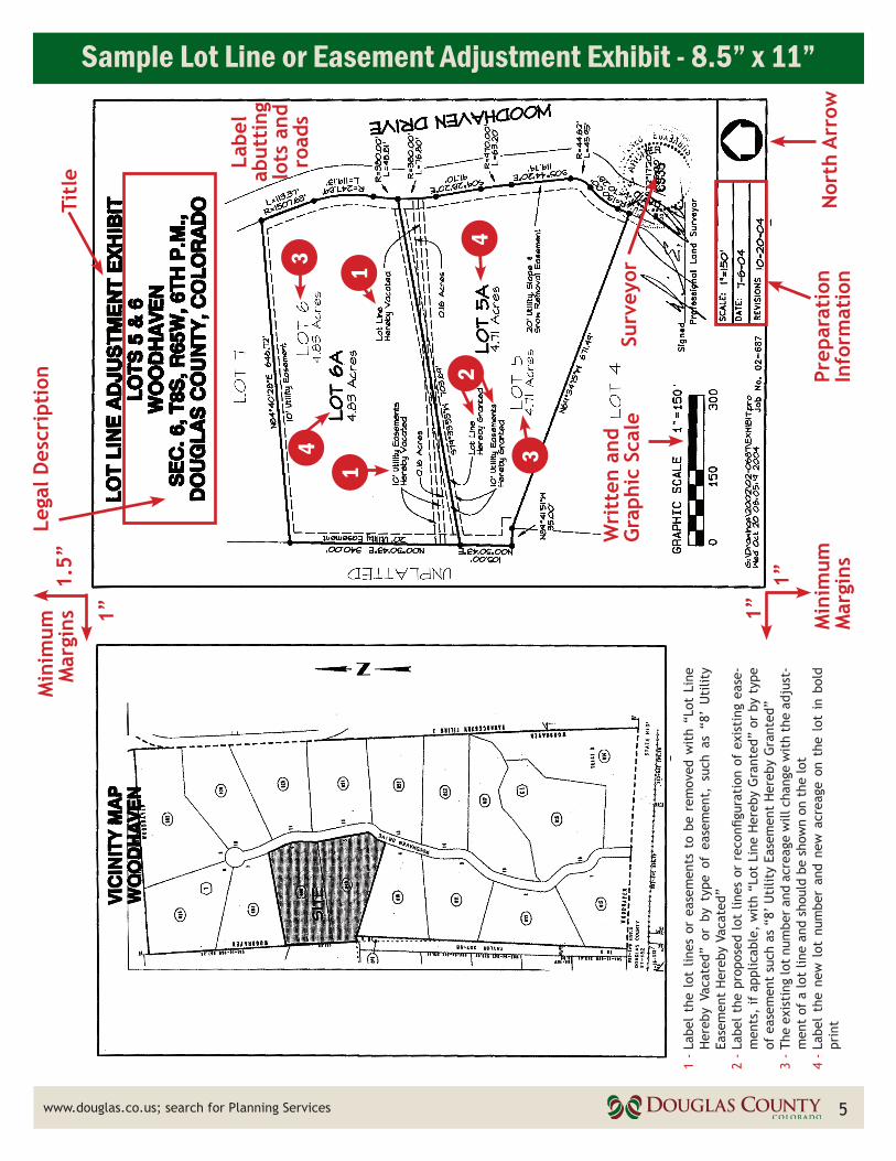
If the lots are within the same subdivision and filing, and can be marked clearly on an 8.5” x 11” sheet of paper, the exhibit (see example on page 5) should include:
� Title centered across the top of the page to reflect the request, such as “Lot Line Adjustment Exhibit,” followed by a legal description of the properties (recorded lot numbers and subdivision name), section, township, range of the property, and Douglas County, Colorado
� Certified boundary survey of the lots prepared by a professional land surveyor, showing the existing and proposed lot or easement configuration including distances and bearings
� North arrow � Written and graphic scale � A 1.5” top margin, 1” side and bottom margin � Preparation date and dates of revisions, if applicable � Label the lot lines or easements to be removed with “Lot Line Hereby Vacated” or by type of easement, such as “8’
Utility Easement Hereby Vacated” � Label the proposed lot lines or reconfiguration of existing easements, if applicable, with “Lot Line Hereby Granted”
or by type of easement such as “8’ Utility Easement Hereby Granted” � The existing lot number and acreage will change with the adjustment of a lot line and should be shown on the lot � The new lot number and new acreage should be shown on the lot in bold print
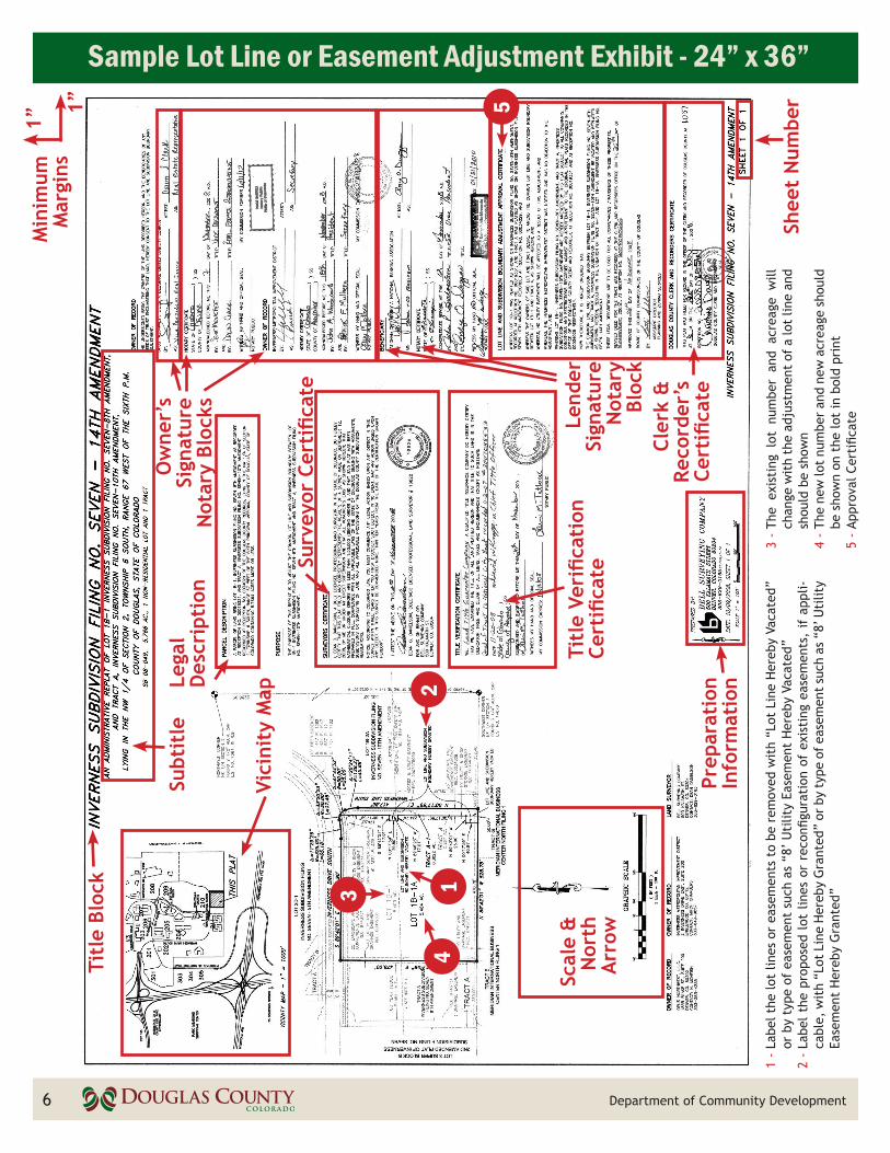
If the lots are next to each other but not within the same subdivision, or cannot clearly be shown on an 8.5” x 11” piece of paper, then a 24” x 36” exhibit is required. The 24” x 36” exhibit (see example page 6) should include:
� Title block should be centered along the top of the long dimension of each sheet and should be identical to the previ-ously recorded plat, followed by the next consecutive amendment number
� The subtitle should include a brief description of the request, section, township, and range of the property, total acreage, total number of lots, and Planning Services project file number
� Title verification certificate (Article 803 of the DCSR) � Surveyor certificate (Article 805 of the DCSR) � Clerk and Recorder certificate (Article 809 of the DCSR)
STEP
STEP
Submittal Checklist (summarized from Article 7A, Section 706A of the DCSR) � Presubmital review � Completed Land Use Application � Written narrative describing the request � Application fee � Copy of a title policy or commitment � Notarized letter from the landowner authorizing a
representative to process the application, if applicable
2
(continued on page 3)
� Stamped envelopes addressed to abutting landowners for courtesy notices
� Lot line or easement adjustment exhibit � Vicinity map of project and surrounding areas � Letters from:
� All special districts providing service to the lots � All known easement beneficiaries, if applicable

Submittal continued
2
www.douglas.co.us; search for Planning Services
Steps 2-6 of the Lot Line or Easement Adjustment Process
STEP
continued
3
Referral Period and Courtesy NotificationReferral Period: 21 daysThe planner prepares a Referral Response Request form and includes it with the Approval Certificate, vicinity map, and ex-hibit. The packet is distributed to the necessary referral agencies. The referral period provides an opportunity for various agencies and other County departments to comment on the application.
The planner forwards referral comments to the applicant as they are received so that the applicant can immediately begin addressing comments directly with the referral agencies. The planner assists in facilitating meetings or discussions between the applicant and referral agencies, as necessary.
Concurrent with the distribution of referral packets, the planner prepares and mails courtesy notices to abutting landowner(s) that state the application is in process.
6STEP
� Signature and notary blocks for owner(s) and lender(s) of all property involved, stating: “The undersigned, being the owner(s) of the land described hereon, and the beneficiaries of any deeds of trust encumbering that land, hereby consent(s) to the lot line adjustment” OR “The undersigned, being the owner(s) of the land described hereon, and there being no beneficiaries of any deeds of trust encumbering that land, hereby consent(s) to this lot line adjust-ment”
� Certified boundary survey of the lots prepared by a professional land surveyor, showing the existing and proposed lots or easement configuration with distances and bearings
� Vicinity map of project and surrounding areas � North arrow � Written and graphic scale � A 1” margin on all sides � Preparation date and dates of revisions, if applicable � Label the lot lines or easements to be removed with “Lot Line Hereby Vacated” or by type of easement such as “8’
Utility Easement Hereby Vacated” � Label the proposed lot lines or reconfiguration of existing easements, if applicable, with “Lot Line Hereby Granted”
or by type of easement such as “8’ Utility Easement Hereby Granted” � The existing lot number and acreage will change with the adjustment of a lot line and should be shown on the lot � The new lot number and new acreage should be shown on the lot in bold � Approval Certificate (see written example on page 7)
Pre-Referral Review
3County Staff’s Goal for Completion: 5 daysPlanning Services and Public Works Engineering staff perform a completeness review to identify any additional information that may be required and comments on any obvious conflicts.
The planner reviews the submittal to ensure compliance with Douglas County’s Comprehensive Master Plan, DCSR, and Douglas County Zoning Resolution (DCZR). If applicable, the planner reviews the request against any Planned Development (PD) requirements and verifies that PD commitments are satisfactorily addressed.
STEP
Applicant RevisionApplicant’s Average: 5 daysThe applicant reviews the pre-referral letter provided by staff and updates the exhibit. It is the applicant’s responsibility to provide any additional exhibits, plans, studies or fees requested by staff in order to proceed with the referral. A prompt resubmittal addressing all staff comments will help achieve a speedy process. 4
STEP
Prepare the Approval CertificateCounty Staff’s Goal for Completion: 5 daysThe exhibit and vicinity map may be submitted in one of two sizes, which affect the preparation of the Certificate, title block, and the resulting legal description of the property. Staff prepares the Approval Certificate for requests shown on an 8.5” x 11” exhibit. 5
STEP
Steps 7-10 of the Lot Line or Easement Adjustment Process
County Staff’s Goal for Completion: 5 daysThe planner ensures all referral responses have been forwarded to the applicant. Following the referral period, the planner provides a post-referral letter to the applicant summarizing any outstanding comments from Planning Services staff and re-ferral agencies that the applicant must address. The applicant is encouraged to meet with the planner and referral agencies to discuss any comments or questions.
If there are no outstanding issues to address, the planner will send the complete Approval Certificate to the applicant to obtain all necessary signatures.
Deeds will be requested at this time if two or more property owners are involved. Deeds must be prepared for the new lots, when a conveyance is part of the process. For example, part of Lot 1 is conveyed to the owner of Lot 2 and becomes part of the new Lot 2A. If all land is under a single owner, the new deeds may be deferred until a lot is conveyed to a new owner.
Department of Community Development
Post Referral Review
7STEP
Applicant Revision and Response
8STEP
Applicant’s Average: 23 daysThe applicant reviews the post-referral letter provided by staff and makes all necessary revisions to the plan exhibit. The applicant addresses the comments of all referral agencies by identifying, in writing, the extent to which the project has been revised in response to the comments.
If there are no outstanding issues or comments to address, the applicant will obtain all signatures needed on the Approval Certificate, or final 24” x 36” mylar exhibit, whichever is being processed. The applicant will also prepare quitclaim deeds and obtain the necessary signatures.
The applicant submits the completed Approval Certificate, or final 24” x 36” mylar exhibit, quitclaim deeds (if applicable), with original, notarized signatures, and any recording fees, to Planning Services for approval. There is no recording fee for the 8.5” x 11” Certificate with exhibit and vicinity map. There is a recording fee for a 24” x 36” mylar exhibit and for all deeds.
ApprovalCounty Staff’s Goal for Completion: 3 daysThe planner reviews the fully signed Certificate, or final 24” x 36” mylar exhibit, and quitclaim deeds (if applicable) to ensure all necessary signatures and format of deeds are correct. Once verified, the planner presents the request to the Director of Community Development for approval.9
STEP
Recordation
10STEP
4
County Staff’s Goal for Completion: 3 daysThe planner will record the approved Certificate, or final 24” x 36” mylar exhibit, and deeds (if applicable), at the Clerk and Recorder’s Office. A copy of the recorded Certificate and deeds (if applicable) will be provided to the applicant.
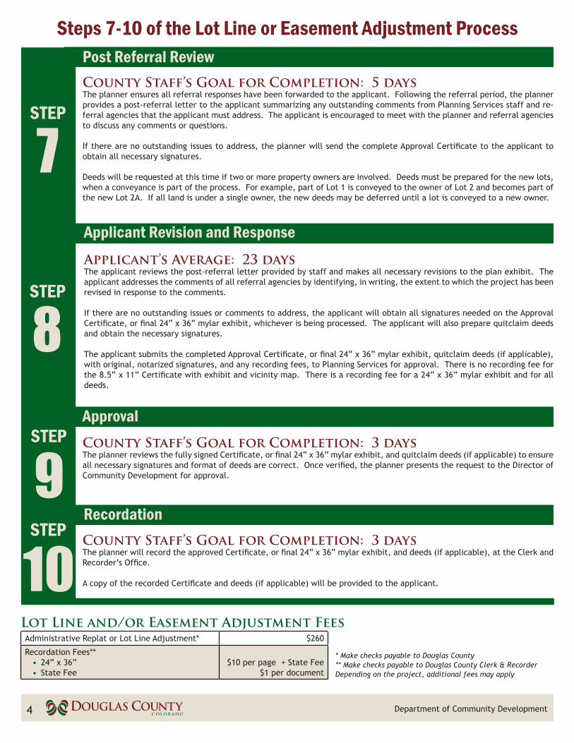
Lot Line and/or Easement Adjustment FeesAdministrative Replat or Lot Line Adjustment* $260
Recordation Fees**• 24” x 36”• State Fee
$10 per page + State Fee
$1 per document
* Make checks payable to Douglas County** Make checks payable to Douglas County Clerk & RecorderDepending on the project, additional fees may apply
www.douglas.co.us; search for Planning Services 5
Sample Lot Line or Easement Adjustment Exhibit - 8.5” x 11”Le
gal D
escr
ipti
onTi
tle
Min
imum
M
argi
ns1.
5”
1”
Wri
tten
and
G
raph
ic S
cale
Min
imum
M
argi
ns1”1”
Nor
th A
rrow
Prep
arat
ion
Info
rmat
ion
Surv
eyor1
1
2
3
3
4
4
1 -
Labe
l th
e lo
t lin
es o
r ea
sem
ents
to
be r
emov
ed w
ith
“Lot
Lin
e H
ereb
y Va
cate
d” o
r by
typ
e of
eas
emen
t, s
uch
as “
8’ U
tilit
y Ea
sem
ent
Her
eby
Vaca
ted”
2
- La
bel
the
prop
osed
lot
lin
es o
r re
confi
gura
tion
of
exis
ting
eas
e-m
ents
, if
app
licab
le,
wit
h “L
ot L
ine
Her
eby
Gra
nted
” or
by
type
of
eas
emen
t su
ch a
s “8
’ U
tilit
y Ea
sem
ent
Her
eby
Gra
nted
” 3
- Th
e ex
isti
ng lo
t nu
mbe
r an
d ac
reag
e w
ill c
hang
e w
ith
the
adju
st-
men
t of
a lo
t lin
e an
d sh
ould
be
show
n on
the
lot
4 -
Labe
l th
e ne
w l
ot n
umbe
r an
d ne
w a
crea
ge o
n th
e lo
t in
bol
d pr
int
Labe
l ab
utti
ng
lots
and
ro
ads
8 Department of Community Development6
Sample Lot Line or Easement Adjustment Exhibit - 24” x 36”
Scal
e &
N
orth
A
rrow
Prep
arat
ion
Info
rmat
ion
Cler
k &
Re
cord
er’s
Ce
rtifi
cate
Shee
t N
umbe
r
Lend
er
Sign
atur
e N
otar
y Bl
ock
Titl
e Ve
rific
atio
n Ce
rtifi
cateSu
rvey
or C
erti
ficat
e
Ow
ner’
s Si
gnat
ure
Not
ary
Bloc
ks
Min
imum
M
argi
ns1”
1”Ti
tle
Bloc
k
Subt
itle
Vici
nity
Map
12
3
4
1 -
Labe
l the
lot
lines
or
ease
men
ts t
o be
rem
oved
wit
h “L
ot L
ine
Her
eby
Vaca
ted”
or
by
type
of
ease
men
t su
ch a
s “8
’ U
tilit
y Ea
sem
ent
Her
eby
Vaca
ted”
2
- La
bel
the
prop
osed
lot
lin
es o
r re
confi
gura
tion
of
exis
ting
eas
emen
ts,
if a
ppli-
cabl
e, w
ith
“Lot
Lin
e H
ereb
y G
rant
ed”
or b
y ty
pe o
f ea
sem
ent
such
as
“8’ U
tilit
y Ea
sem
ent
Her
eby
Gra
nted
”
3 -
The
exis
ting
lot
num
ber
and
acre
age
will
ch
ange
wit
h th
e ad
just
men
t of
a lo
t lin
e an
d sh
ould
be
show
n 4
- Th
e ne
w lo
t nu
mbe
r an
d ne
w a
crea
ge s
houl
d be
sho
wn
on t
he lo
t in
bol
d pr
int
5 -
Appr
oval
Cer
tific
ate
Lega
l D
escr
ipti
on
5
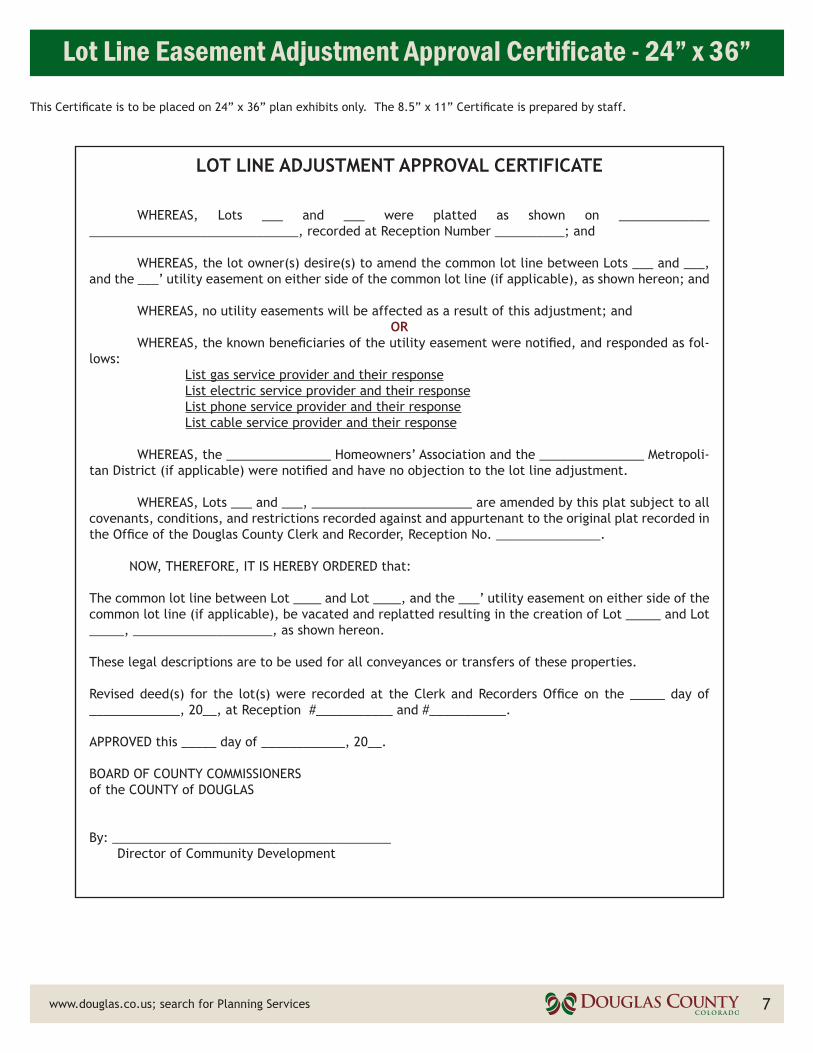
Lot Line Easement Adjustment Approval Certificate - 24” x 36”
www.douglas.co.us; search for Planning Services 7
LOT LINE ADJUSTMENT APPROVAL CERTIFICATE
WHEREAS, Lots ___ and ___ were platted as shown on _____________ ______________________________, recorded at Reception Number __________; and
WHEREAS, the lot owner(s) desire(s) to amend the common lot line between Lots ___ and ___, and the ___’ utility easement on either side of the common lot line (if applicable), as shown hereon; and
WHEREAS, no utility easements will be affected as a result of this adjustment; andOR
WHEREAS, the known beneficiaries of the utility easement were notified, and responded as fol-lows: List gas service provider and their response List electric service provider and their response List phone service provider and their response List cable service provider and their response
WHEREAS, the _______________ Homeowners’ Association and the _______________ Metropoli-tan District (if applicable) were notified and have no objection to the lot line adjustment.
WHEREAS, Lots ___ and ___, _______________________ are amended by this plat subject to all covenants, conditions, and restrictions recorded against and appurtenant to the original plat recorded in the Office of the Douglas County Clerk and Recorder, Reception No. _______________.
NOW, THEREFORE, IT IS HEREBY ORDERED that:
The common lot line between Lot ____ and Lot ____, and the ___’ utility easement on either side of the common lot line (if applicable), be vacated and replatted resulting in the creation of Lot _____ and Lot _____, ____________________, as shown hereon.
These legal descriptions are to be used for all conveyances or transfers of these properties.
Revised deed(s) for the lot(s) were recorded at the Clerk and Recorders Office on the _____ day of _____________, 20__, at Reception #___________ and #___________.
APPROVED this _____ day of ____________, 20__.
BOARD OF COUNTY COMMISSIONERSof the COUNTY of DOUGLAS
By: ________________________________________ Director of Community Development
This Certificate is to be placed on 24” x 36” plan exhibits only. The 8.5” x 11” Certificate is prepared by staff.