groundwater monitoring quality assurance/quality …
TRANSCRIPT

GROUNDWATER MONITORING QUALITY ASSURANCE/QUALITY CONTROL PLAN
LOWER YAKIMA VALLEY GWMA INITIAL CHARACTERIZATION
September 16, 2013

GROUNDWATER MONITORING QUALITY ASSURANCE/QUALITY CONTROL PLAN
LOWER YAKIMA VALLEY GWMA INITIAL CHARACTERIZATION
Prepared for:
Yakima County 128 N. Second Street
Yakima, Washington 98901
Prepared by:
Pacific Groundwater Group 2377 Eastlake Avenue East, Suite 200
Seattle, Washington 98102 206.329.0141
www.pgwg.com
September 16, 2013 JE1308
FinalQAQCPlan-v091613.docx

Groundwater Monitoring QA/QC Plan iii LYV GWMA Initial Characterization SEPTEMBER 16, 2013
TABLE OF CONTENTS
1.0 INTRODUCTION ........................................................................................................................... 1
1.1 OBJECTIVE ..................................................................................................................................... 1 1.2 PARAMETERS OF CONCERN AND PROJECT MCLS .......................................................................... 2
2.0 DATA QUALITY OBJECTIVES .................................................................................................. 3
2.1 STATION DATA QUALITY OBJECTIVES ........................................................................................... 3 2.2 ANALYTICAL DATA QUALITY OBJECTIVES .................................................................................... 4
3.0 QUALITY CONTROL CHECKS ................................................................................................. 6
3.1 FIELD QUALITY CONTROL ............................................................................................................. 6 3.2 LABORATORY QUALITY CONTROL ................................................................................................ 7
4.0 DATA VALIDATION AND USEABILITY .................................................................................. 7
5.0 REFERENCES ................................................................................................................................ 9
TABLES
Table 1: Water Quality Parameters of Concern and Analytical Methods Table 2: Relevant Regulatory Water Quality Standards and LYV GWMA Project MCLs Table 3: Field Quality Control Summary
FIGURES
Figure 1: Boundary of the Lower Yakima Valley Groundwater Management Area Figure 2: Decision Tree for Data Usability, Station Metadata Figure 3: Decision Tree for Data Usability, Analytical Metadata

Groundwater Monitoring QA/QC Plan iv LYV GWMA Initial Characterization SEPTEMBER 16, 2013
QA/QC APPROVALS
This Groundwater Monitoring QA/QC Plan, developed September 16, 2013 for the Lower Yakima Valley Groundwater Management Area, has been reviewed and approved by the undersigned. Copies of the completed and signed QA/QC Plan shall be distributed to the undersigned and all field personnel.
Lower Yakima Valley Groundwater Management Committee Date
Project Manager Date
Analytical Lab Project Manager Date
QC Coordinator Date
Field Manager Date

Groundwater Monitoring QA/QC Plan v LYV GWMA Initial Characterization SEPTEMBER 16, 2013
This Groundwater Monitoring Quality Assurance/Quality Control Plan has been prepared as an appendix to the forthcoming Groundwater Monitoring Plan, which has an anticipated publication date of March 2014. References to the Groundwater Monitoring Plan within this appendix should be understood as information that will be available in the future.
Project Background, Project Objectives, Scope of Work, and Sampling Protocols will be detailed in the Groundwater Monitoring Plan and are not included herein.
This work was performed under HDR contract #CON0082545 and partially fulfills scope Item 1a. The QA/QC Plan was prepared in accordance with hydrogeologic practices generally accepted at this time in this area, for the exclusive use of the Lower Yakima Valley Groundwater Advisory Committee and HDR, for specific application to the Initial Characterization. No other warranty, express or implied, is made.

Groundwater Monitoring QA/QC Plan 1 LYV GWMA Initial Characterization SEPTEMBER 16, 2013
1.0 INTRODUCTION
This Quality Assurance/Quality Control (QA/QC) Plan has been developed as an appendix to the Groundwater Monitoring Plan for the Lower Yakima Valley Groundwater Management Area (LYV GWMA) Initial Characterization. The QA/QC Plan has been prepared in general accord with U.S. Environmental Protection Agency (EPA) (EPA, 2002) and Washington State Department of Ecology (Ecology) (Ecology, 2004) guidelines and specifications. This document addresses:
• Data Quality Objectives for stations (groundwater and drain-water quality sampling stations) and analytical data
• Quality Control Checks for field and laboratory
• Analytical methods
• Data Validation and Usability
While this QA/QC Plan is intended to be comprehensive, revisions and/or amendments may be required as the project evolves. Descriptions of the project background, project objectives, scope of work, and field protocols are provided in the Groundwater Monitoring Plan.
1.1 OBJECTIVE
The Initial Characterization will be developed from existing water quality data collected during previous investigations, and future water quality data that will be collected as described in the Groundwater Monitoring Plan. The Initial Characterization will be used by the LYV Groundwater Advisory Committee (GWAC) to make administrative decisions and policy recommendations; therefore, the data inputs must be reliable and defensible. This QA/QC Plan defines the quality of data necessary for various uses within the Initial Characterization.
“Core data” as used in this project is the information that Pacific Groundwater Group recommended for inclusion in the project database related to groundwater and drain-water quality samples (PGG, 2013). These data include analytical and field test results for parameters of concern (Section 1.2), station location, and well construction information.
QA/QC data for the project consists of information that documents the accuracy and precision of the analytical results. Each analytical batch should have associated QA/QC data, which may include results of method blanks, laboratory replicates, and field duplicates. QA/QC data, where available, will also be uploaded to the project database for the parameters of concern.
Data Quality Objectives (DQO) for the project are described in Section 2.0 of this QA/QC Plan. Station DQOs will be used to evaluate lateral and vertical distribution of the sampling network and to evaluate potential bias that could be introduced from treatment or wells with poor surface seals. Analytical DQOs will be used to evaluate representativeness, precision, and potential bias from sampling or lab artifacts. Stations

Groundwater Monitoring QA/QC Plan 2 LYV GWMA Initial Characterization SEPTEMBER 16, 2013
and analytical sets that do not meet DQOs may be qualified or considered unacceptable for some or all project needs.
1.2 PARAMETERS OF CONCERN AND PROJECT MCLS
As described in the Groundwater Monitoring Plan, the LYV GWMA was formed in response to elevated nitrate concentrations in groundwater in Lower Yakima Valley. The boundaries of the GWMA are presented in Figure 1. The concentrations of nitrate detected in groundwater indicate impact by human activity and may pose significant risk to human health in localized areas. The LYV GWMA was formed with the stated purpose of reducing nitrate concentrations in groundwater to below drinking water standards.
Based on previous investigations and the LYV GWMA’s purpose, the parameters of concern for this study are:
• Nitrate
• Nitrite
• Ammonia-nitrogen
• Sum of organic nitrogen + ammonia + ammonium (Total Kjeldahl Nitrogen)
These parameters are a subset of inorganic parameters that are referred to as conventionals. Analytical methods and holding times (from sample collection to analysis) are summarized in Table 1. The analytical method list in Table 1 was derived from Ecology’s Methods and Analytes Table on their environmental lab accreditation website (Ecology, n.d.). If there are discrepancies regarding preservation or holding time between Table 1 and the analytical method, the analytical method shall be considered correct.
Method detection limits (MDLs) are the minimum concentration of an analyte that can be identified, measured, and reported with 99 percent confidence that the analyte concentration is greater than zero. Analytical methods may specify MDLs or may describe procedures for establishing MDLs. Practical Quantitation Limits (PQLs) or lab Reporting Limits are the minimum concentration of an analyte that can be reliably achieved during routine laboratory operating conditions within specified limits of precision and accuracy. PQLs and Reporting Limits are greater than MDLs and are statistically determined by individual labs. Because the analytical labs for this project have not been identified, PQLs and lab Reporting Limits cannot be specified in this QA/QC Plan. PQLs and lab Reporting Limits must be less than the LYV GWMA Project Maximum Contaminant Levels (MCLs) defined below.
Water quality standards or criteria established by regulatory agencies will be used to evaluate analytical results for the parameters of concern listed above. Standards applicable to the LYV GWMA groundwater studies are EPA MCLs, Washington State Public Water Supply MCLs (WAC 246-290-310), and Washington State Groundwater Quality Criteria (WAC 173-200-050). Established standards for the LYV GWMA parameters of concern are generally consistent between these regulations (Table 2). LYV GWMA Project MCLs are based on the most stringent relevant regulatory water quality standards and are summarized in Table 2.
Water quality standards have not been established for ammonia-nitrogen or the sum of organic nitrogen + ammonia + ammonium under the regulations cited above; however,

Groundwater Monitoring QA/QC Plan 3 LYV GWMA Initial Characterization SEPTEMBER 16, 2013
these analytical results may be useful for trend evaluation and for understanding nitrogen speciation.
2.0 DATA QUALITY OBJECTIVES
DQOs are qualitative and quantitative criteria established to limit uncertainty in analytical results. They are established to create analytical data sets that will support the study objectives. It is important to meet DQOs in order to produce analytical results that are considered defensible and reliable.
2.1 STATION DATA QUALITY OBJECTIVES
“Station Metadata” for this project refers to physical and access details about sampling stations, including the type of station (well or drain), location, owner and/or tenant name and contact information, well construction, and sampling point. Station DQOs will be used to:
• Understand the lateral distribution of the stations
• Understand what aquifer system (e.g. shallow or deep) the stations represent
• Understand potential bias in samples from surface contamination
• Understand potential bias in samples from treatment
• Identify stations for long-term monitoring consideration
A decision tree for evaluating Station Metadata against DQOs is presented in Figure 2. The DQOs may be used to evaluate those stations acceptable for Data Gap and Trend Analyses, and those acceptable for Long-Term Monitoring.
Data Gap and Trend Analyses DQOs. Station location and indication of completion depth for wells are the DQOs for a station to be considered for Data Gap and Trend Analyses. Locations must be available by either coordinates in a known datum (preferred) or by a current parcel number. Station location information may be refined during field work. For wells, documented depth information must be available either for the open interval (preferred) or for the total depth of the well. Well depth should be documented on a well log, video log, maintenance log, pump installation records, or similar means of documentation. An owner’s recollection of total depth will not be considered valid documentation. Depth information is not required for drain stations.
Long-Term Monitoring Consideration DQOs. To be considered for Long-Term Monitoring, stations must meet the Data Gap and Trend Analyses DQOs plus long-term access to the station must be available. For well stations, the sampling port should be upstream of treatment and an adequate surface seal should be documented. Long-term access and information about available sampling ports may be collected during field work. Special consideration may be given to wells that do not meet the sampling port relative to treatment criterion and surface seal criterion in areas with limited stations; however, comparison of analytical results relative to project MCLs would not be valid.
Groundwater Monitoring QA/QC Plan 4 LYV GWMA Initial Characterization SEPTEMBER 16, 2013
2.2 ANALYTICAL DATA QUALITY OBJECTIVES
QA/QC data associated with water quality samples can be used to assess the accuracy and precision of the analytical results. This QA/QC Plan stipulates the QA/QC data required for water quality samples, and the DQOs to evaluate the QA/QC data against. However, it is likely that some water quality data from previous investigations will not have available QA/QC data.
The availability and acceptability of QA/QC data will affect how sample results may be used in the GWMA Initial Characterization. A decision tree to assess usability of the analytical metadata is presented in Figure 3. If station location and depth information is available (Section 2.1), all existing analytical data will be considered in the evaluation of Data Gaps and Trends, regardless of whether associated QA/QC data are available. Water quality results with available QA/QC data that meet DQOs described in this section and water quality results associated with the Washington State Department of Health (DOH) compliance monitoring of public water systems will be considered in the evaluation of Data Gaps and Trends, and in addition will be used to establish Baseline Water Quality, evaluate Compliance with project MCLs, and establish Long-Term Monitoring Data. While QA/QC data associated with DOH compliance monitoring are not available, the data will be considered acceptable for the additional evaluations because the analytical labs are required to be accredited by Ecology; and samples are required to be collected and transported according to EPA or DOH approved methods (WAC 246-290-300 and WAC 246-291-300).
DQOs for analytical data are typically expressed in terms of accuracy, precision, representativeness, completeness, and comparability. Definitions of these terms follow.
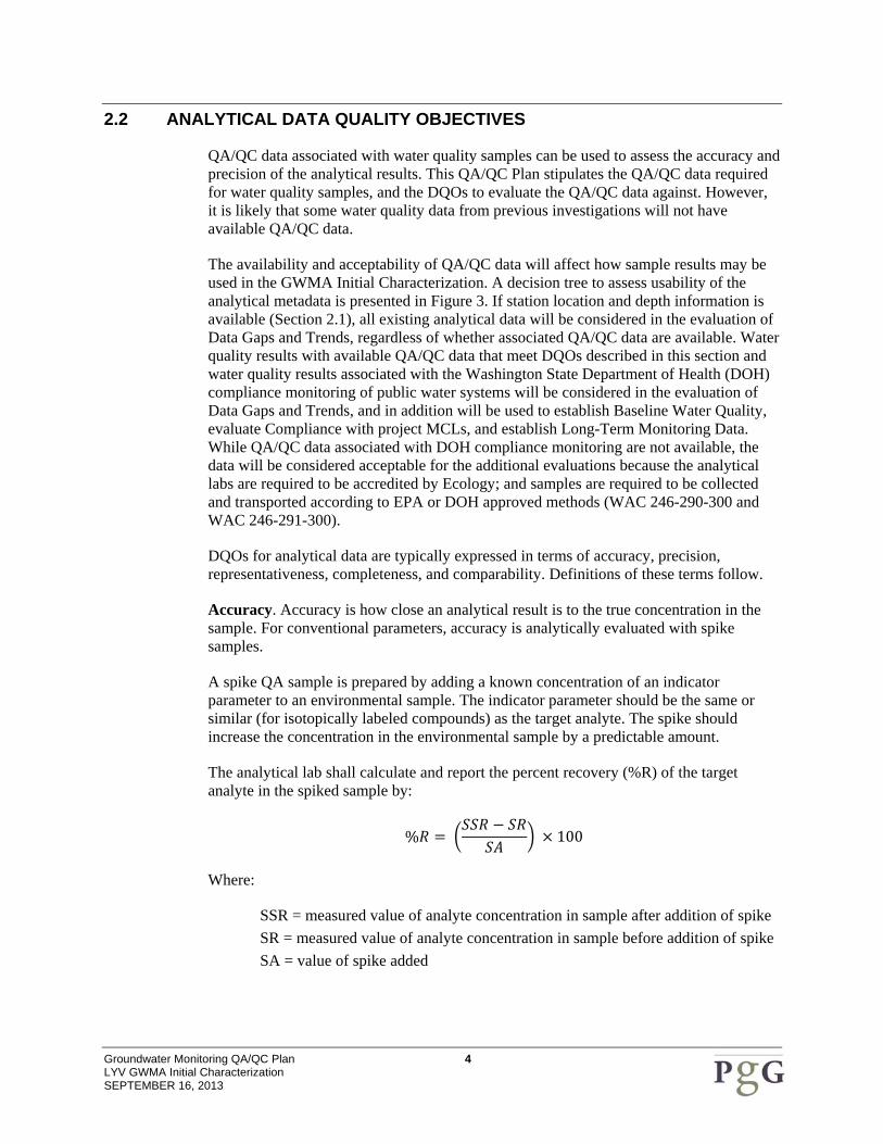
Accuracy. Accuracy is how close an analytical result is to the true concentration in the sample. For conventional parameters, accuracy is analytically evaluated with spike samples.
A spike QA sample is prepared by adding a known concentration of an indicator parameter to an environmental sample. The indicator parameter should be the same or similar (for isotopically labeled compounds) as the target analyte. The spike should increase the concentration in the environmental sample by a predictable amount.
The analytical lab shall calculate and report the percent recovery (%R) of the target analyte in the spiked sample by:
% 100
Where:
SSR = measured value of analyte concentration in sample after addition of spike SR = measured value of analyte concentration in sample before addition of spike SA = value of spike added

Groundwater Monitoring QA/QC Plan 5 LYV GWMA Initial Characterization SEPTEMBER 16, 2013
The LYV GWMA QA Reviewer (QA Reviewer) shall evaluate accuracy by comparing the %R to acceptable limits statistically determined by the laboratory (Section 4).
Precision. Precision measures the reproducibility of results and can be evaluated through field duplicate (collocated samples collected in the field that are analyzed independently) and lab replicate (aliquots prepared in the lab of the same sample that are analyzed independently).
Field duplicates will be collected on at least a 10 percent frequency (1 duplicate per 10 samples collected). At least one field duplicate shall be collected each event (Section 3.1). Lab replicates may be analyzed according to an individual lab’s Standard Operating Procedure (SOP). Lab replicates are prepared in the lab by taking an aliquot of an environmental sample and treating that aliquot throughout the analytical method as though it were another sample.
Relative Percent Differences (RPD) values between field duplicates shall be calculated by the QA Reviewer and RPD values between lab replicates shall be calculated and reported by the lab. RPDs are calculated by:
| 1 2 |
1 22
100
Where:
D1 = measured concentration of duplicate or replicate 1 D2 = measured concentration of duplicate or replicate 2
The QA Reviewer shall evaluate precision by comparing the RPD to acceptable limits (Section 4). For this study, the acceptable RPD limits for field duplicates shall be 20 percent or ± the lab reporting limit if the concentration of either the sample or duplicate is less than 5 x the lab reporting limit. The acceptable RPD limits for lab replicates shall be statistically established by the analytical lab.
Representativeness and Comparability. Representative samples accurately represent the environmental matrix being tested. Comparable samples are collected during different sampling events, but at the same station. For this study, representativeness and comparability shall be achieved by following the field sampling protocols and methods described in the Groundwater Monitoring Plan, using the same analytical methods, and to the degree possible, the same analytical lab.
As described in the Groundwater Monitoring Plan, the majority of water samples collected for this study will be collected directly into laboratory-provided bottles without the use of non-dedicated or non-disposable sampling devices such as bailers, portable pumps, dippers, or grab samplers. When non-dedicated or non-disposable sampling devices are used, representativeness and comparability will be evaluated using rinsate or decontamination blanks (Section 3.1). These blanks will be collected following decontamination of the sampling device, on at least a 10 percent frequency (1 blank per 10 samples collected with a non-dedicated or non-disposable sampling device) and a

Groundwater Monitoring QA/QC Plan 6 LYV GWMA Initial Characterization SEPTEMBER 16, 2013
minimum of 1 blank will be collected per event where non-dedicated sampling devices are used.
Completeness. Completeness is the percentage of valid results obtained from a given sampling event. For this study, completeness is anticipated to be equal or better than 85 percent.
3.0 QUALITY CONTROL CHECKS
Quality control checks will be performed by project field staff and by the analytical lab as described below.
3.1 FIELD QUALITY CONTROL
Field quality control checks are summarized in Table 3.
Field Duplicates will be collected at a rate of at least 10 percent as described in Section 2.0. After collection of the original sample, a duplicate shall be collected by filling another set of laboratory-provided bottles using the same sampling procedure. Field duplicates shall be analyzed for each parameter of interest. Field duplicates will be labeled with a unique sample ID and collection date/time. Field sample forms shall document the stations where field duplicates were collected, the duplicate ID, and duplicate sample time.
Rinsate or decontamination blanks will be collected at a rate of at least 10 percent of samples collected per sampling team with non-disposable or non-dedicated equipment. After the non-dedicated equipment is decontaminated following procedures described in the Groundwater Monitoring Plan, a rinsate or decontamination blank shall be collected by transferring commercially available distilled water from the sampling equipment to a set of laboratory-prepared bottles, or by pouring distilled water over the equipment and collecting the water that that rinses off in a set of laboratory-prepared bottles. The rinsate or decontamination blank shall be labeled with a unique sample ID and collection date/time. Field sample forms shall document the stations where field blanks were collected, the blank ID, and blank sample date/time.
Matrix Spike and Matrix Spike Duplicates (MS/MSD) will be analyzed per batch of samples. If groundwater and ditch-water samples are collected in a single sampling event, MS/MSDs should be analyzed for both station types. MS/MSDs prepared from samples collected for the LYV GWMA project are preferred over MS/MSDs prepared from samples collected for another project that may be part of the same analytical batch. This may require additional volume to be collected in the field. The Field Sampling Manager or Lead should confer with the analytical lab about additional volume requirements when placing the bottle order. Sample bottles for MS/MSD analysis will be labeled with the station ID followed by “-MS/MSD” and field forms will document where the MS/MSD are collected.

Groundwater Monitoring QA/QC Plan 7 LYV GWMA Initial Characterization SEPTEMBER 16, 2013
3.2 LABORATORY QUALITY CONTROL
Analytical services for this study will be provided by labs accredited by Ecology for drinking water or non-potable water analyses of the parameters of concern (there are currently no drinking water accredited labs for analyses of ammonia or TKN, there are non-potable water accredited labs for these parameters). Prior to mobilization to the field, the lab will provide proof of Ecology accreditation for analytical methods and matrices related to this QA/QC Plan. Labs routinely perform performance checks and each analytical method requires specific QA/QC protocols that must be complied with by the lab. No additional audits will be performed on the analytical labs for this study.
The analytical lab will follow their written QA/QC Plan and Standard Operating Procedures (SOP) to assure data quality. Lab QC samples will be analyzed in accordance with the lab QA/QC Plan, SOP, and analytical method and may include the following:
• Method blanks are used to assess contamination that may be introduced in the lab during sample preparation. Method blanks are prepared, extracted, digested, and analyzed in the same manner as field samples. Analytical results will be included in lab reports.
• Laboratory control samples (LCS) are used to evaluate the performance of the total analytical system, including all preparation and analysis steps. They contain known concentrations of the analytes of interest and the percent recovery reflects the accuracy of the analysis. Analytical results will be included in lab reports.
Lab QA/QC also typically includes instrument-related calibration blanks and performance checks. Instrument-related QA/QC results will not be included in lab reports, but will be made available on request if other QA/QC results are considered unacceptable.
4.0 DATA VALIDATION AND USEABILITY
Data validation will be performed by the lab in accordance with their QA/QC plan and SOP prior to the release of the analytical results. The lab shall document their data validation in a case narrative, identifying any QA/QC recoveries that were outside the lab’s acceptance criteria, and potentially flagging or reanalyzing unacceptable results.
The QC Reviewer will review field notes for compliance with sampling protocols described in the Groundwater Monitoring Plan and will validate the analytical data in accordance with the QA/QC requirements specified in this QA/QC Plan and the analytical methods. The analytical reports shall be checked for completeness that the data requested has been delivered. They shall also be checked for compliance of the analytical QA/QC results with acceptance limits. Data validation will also include review of the method blanks, holding times, and lab reporting limits.
DQOs or acceptance limits for Percent Recoveries (%R) of spike samples, including matrix spikes, shall be established statistically by the lab and provided in the lab reports. In the event that statistical acceptance limits are not available, the following limits from the Quality Assurance Project Plans for the Yakima Basin Nitrate Study Phase 3 (U.S.

Groundwater Monitoring QA/QC Plan 8 LYV GWMA Initial Characterization SEPTEMBER 16, 2013
EPA, 2010b) and Lower Yakima Valley Dairy Investigation (SAIC, 2012) shall be applied:
• Accuracy (percent recovery of spikes including laboratory control samples and matrix spikes): 80-120 percent
• Precision (lab replicate and matrix spike duplicate): ± 20 percent
For this study, the acceptable RPD limits for field duplicates shall be 20 percent or ± the lab reporting limit if the concentration of either the sample or duplicate is less than 5 x the lab reporting limit.
Data associated with QA/QC results that fall outside acceptance limits may be qualified or rejected. The EPA Contract Laboratory Program National Functional Guidelines for Inorganic Superfund Data Review (EPA 2010a) generally do not extend to conventional parameters; however, the guidelines may be referred to for qualification guidance. Findings and conclusions of the Data Validation will be summarized in a narrative by the QC Reviewer.
As presented in Figure 3 and described in Section 2.2, all existing analytical data will be considered in the evaluation of Data Gaps and Trends, regardless of whether associated QA/QC data are available or whether associated QA/QC data meet Analytical DQOs (acceptance limits) described in this Plan. Analytical results with QA/QC data that meet DQOs and analytical data associated with DOH compliance monitoring of public water systems will be considered to meet project needs to be valid for: Data Gaps and Trend analyses, establishing Background Water Quality, evaluating Compliance with project MCLs, and establishing Long-Term Monitoring Data.
Groundwater Monitoring QA/QC Plan 9 LYV GWMA Initial Characterization SEPTEMBER 16, 2013
5.0 REFERENCES
Pacific Groundwater Group, 2013. Core Data Recommendations. Consultant’s technical memorandum prepared for Yakima County and HDR. July 29, 2013.
SAIC. 2012. Quality Assurance Project Plan Lower Yakima Valley Dairy Investigation Yakima County, Washington. Consultant’s plan prepared for U.S. Environmental Protection Agency, Region 10. December 2012.
U.S. Environmental Protection Agency, 2002. Guidance for Quality Assurance Project Plans. EPA QA/G-5. EPA/240/R-02/009. December 2002.
U.S. Environmental Protection Agency, 2010a. USEPA Contract Laboratory Program National Functional Guidelines for Inorganic Superfund Data Review. January, 2010.
U.S. Environmental Protection Agency, 2010b. Quality Assurance Project Plan For Yakima Basin Nitrate Study Phase 3 – Comprehensive Analytical Source Tracer April 2010 Sampling Event Yakima County. U.S. EPA Region 10. April 8, 2010.
Washington State Department of Ecology, 2004. Guidelines for Preparing Quality Assurance Project Plans for Environmental Studies. Publication No. 04-03-030. Revision of Publication No. 01-03-003. July 2004.
Washington State Department of Ecology, n.d. Methods and Analytes Table. http://www.ecy.wa.gov/programs/eap/labs/lab-accreditation.html. Web. September 4, 2013.

Table 1. Water Quality Parameters of Concern and Analytical Methods
Parameter Analytical Method Preservative Holding Time Bottle Type
Ammonia‐NEPA 350.1 /
SM 4500 / USGS 1‐2522‐90 / USGS 1‐3520‐85
H2SO4 28 days Lab Provided
Nitrate+NitriteEPA 353.2 / EPA 300.0 / EPA 300.1 / SM 4500 /
SM 4110
H2SO4 (see holding
time)
48 hours (unpreserved)
28 days (preserved)Lab Provided
NitrateEPA 353.2* / EPA 300.0 /
EPA 300.1 / SM 4500 / SM 4110
48 hours Lab Provided
NitriteEPA 353.2* / EPA 300.0 /
EPA 300.1 / SM 4500 / SM 4110
48 hours Lab Provided
Sum of organic nitrogen + ammonia + ammonium (Total Kjeldahl Nitrogen (TKN))
EPA 351.1 / EPA 351.2 / SM 4500
H2SO4 28 days Lab Provided
*Method may be used to determine nitrite or nitrate singly, or nitrate+nitrite. If nitrate is determined singly, nitrite may be calculated from the nitrate+nitrite result. Similarly, if nitrite is determined singly, nitrate may be calculated from the nitrate+nitrite result.
Analytical Methods consistent with Ecology's Methods and Analytes Table at: http://www.ecy.wa.gov/programs/eap/labs/lab‐accreditation.html
Discrepancies between Preservation/Holding Time between this table and the Analytical Methods should be resolved in favor of the Analytical Method
Practical Quantitation Limits/Lab Reporting Limits for these methods are determined by individual labs and are therefore not specified in this QA/QC Plan. Practical Quantitation Limits/Lab Reporting Limits must be less than Project MCLs.
Groundwater QA/QC PlanLYV GWMA Initial CharacterizationSeptember 16, 2013

Table 2. Relevant Regulatory Water Quality Standards and LYV GWMA Project MCLs
EPA MCLsWA Public Water Supply MCLs
WA Groundwater Quality Criteria
Ammonia‐N Not Established Not Established Not Established Not Established
Nitrate+Nitrite Not Established Not Established Not Established Not Established
Nitrate (as N) 10 mg/L 10 mg/L 10 mg/L 10 mg/L
Sum of organic nitrogen + am 1 mg/L 1 mg/L Not Established 1 mg/L
Sum of organic nitrogen +
ParameterLYV GWMA Project MCLs
Relevant Regulatory Water Quality Standards
Groundwater QA/QC PlanLYV GWMA Initial CharacterizationSeptember 16, 2013
ammonia + ammonium (Total Kjeldahl Nitrogen (TKN))
Not Established Not Established Not Established Not Established
EPA MCLs established by Safe Drinking Water Act (SDWA)
WA Public Water Supply MCLs established by WAC 246‐290‐310
WA Groundwater Quality Criteria established by WAC 173‐200‐050
Practical Quantitation Limits/Lab Reporting Limits for these methods are determined by individual labs and are therefore not specified in this QA/QC Plan. Practical Quantitation Limits/Lab Reporting Limits must be less than Project MCLs.
Groundwater QA/QC PlanLYV GWMA Initial CharacterizationSeptember 16, 2013

Table 3. Field Quality Control Summary
Type of Quality Control Check
Minimum Frequency Bottle ID Process
Field Duplicates1 per 10 samples
collectedStation ID + 200
After collection of the original sample, fill a second set of laboratory‐provided bottles using the same sampling procedure. Label the duplicate uniquely and analyze for all sampling event parameters.
Rinsate/Decontamination Blank
1 per 10 samples per team collected with non‐
disposable or non‐dedicated equipment
Station ID + 100
Decontaminate the non‐dedicated/non‐disposable equipment following procedures described in the Work Plan. Transfer commercially available distilled water from the sampling equipment to a set of laboratory‐prepared bottles, or pour DI water over the equipment and collect the water that rinses off in a set of lab‐prepared bottles. Label the blank uniquely and analyze for all sampling event parameters.
MS/MSD1 for each station type (well
or drain) per eventStation ID + "‐MS/MSD"
After collection of the original sample, fill a second and third set of laboratory‐provided bottles using the same sampling procedure. Label the bottles with the addition of "‐MS/MSD" and analyze for all sampling event parameters.
Groundwater QA/QC PlanLYV GWMA Initial CharacterizationSeptember 16, 2013

Yakim
a Cou
ntyBe
nton C
ounty
T o p p e n i s h R i d g e
A h t a n u m R i d g e
R a t t l e s n a k e H i l l s
H o r s e H e a v e n H i l l s
U n i o nG a p
S n i p e s M o u n t a i n
Sunnyside
Grandview
Zillah
Toppenish
Granger
Wapato
Mabton
Yakima R
Glade Cr
Satus Cr
Toppenish Cr
Satus Cr
Status
Cr
Yakima R
Mule Dry Cr
Y a k a m aY a k a m a N a t i o n N a t i o n
§̈¦82
¬«24
¬«241
¬«22
¬«223
K:\PONY\Yakima Basin GWMA\GIS\mxds\GWMA_bndy_updated.mxd 8/26/2013
Figure 1
Boundary of the Lower Yakima Valley Groundwater Management Area
GWMA Boundary
0 5MilesKImage derived from Landsat 7 data (1999 - 2002)
Yakama Nation Boundary (from Yakima County)

Station Metadata
Is x, y Location Available with
Co‐ordinates and Datum ?
Station Data Meets DQO for Data Gap and Trend
Station Data Does Not Meet Minimum
DQO
YesNo
Yes
No
Is Current Parcel Number Available?
Is Station a Well?
Yes No
Is Depth or Open Interval Information
Available?No
Yes for Data Gap and Trend Analyses
Station Data Meets DQO for Long‐Term Monitoring
Consideration
Figure 2.Decision Tree for Data Usability, Station Metadata
LYV GWMA QA/QC Plan
Yes
Is Long Term Access Available?
Station Data Does Not Meet DQO for Long‐Term
Monitoring Consideration
Yes
No
Is Sampling Port Upstream of Treatment and Is Adequate Surface Seal Documented?
Yes
No
Is Station a Well?
No
Yes

Analytical Metadata
Is Associated QA/QCData Available?
YesDoes QA/QC Data Meet DQOs?
Analytical Data Usable for Data Gap and Trend Analyses
Is Analytical Data Associated with DOH Public Water System
Compliance Monitoring?YesNo
Figure 3.Decision Tree for Data Usability, Analytical Metadata
LYV GWMA QA/QC Plan
No
YesNo
Analytical Data Usable for: Baseline, Comparison to MCLs, and Long‐
Term Monitoring
Analytical Data Not Usable for Baseline, Comparison to MCLs, or
Long‐Term Monitoring
