groundwater management plan
TRANSCRIPT

Hillside Copper Mine Groundwater Management Plan Program for Environment Protection and Rehabilitation (PEPR)
GROUNDWATER MANAGEMENT PLAN

Hillside Copper Mine Groundwater Management Plan Program for Environment Protection and Rehabilitation (PEPR)
Table of Contents DOCUMENT OWNER .................................................................................................... 1
DOCUMENT APPROVER .............................................................................................. 1
REVISION HISTORY .................................................................................................... 1
DEFINITION OF TERMS ............................................................................................... 2
1. INTRODUCTION .............................................................................................. 3
1.1 ENVIRONMENTAL MANAGEMENT SYSTEM ........................................................................ 3
1.2 OBJECTIVES ............................................................................................................................ 3
1.3 REGULATORY REQUIREMENTS ........................................................................................... 3
1.3.1 Natural Resources Management Act 2004 (SA) ....................................................... 3
1.3.2 Environment Protection Act 1993 (SA) ...................................................................... 4
2. GROUNDWATER CONDITIONS ....................................................................... 4
3. GROUNDWATER OUTCOMES ......................................................................... 5
4. BASELINE MEASUREMENTS .......................................................................... 6
5. UNCERTAINTY ASSESSMENT ...................................................................... 14
6. KEY RISKS .................................................................................................... 15
7. CONTROL MEASURES .................................................................................. 15
7.1 GROUNDWATER QUALITY ...................................................................................................15
7.2 RSF AND TSF CONTROL MEASURES .................................................................................16
8. CONSULTATION ........................................................................................... 16
9. RESPONSE PROCEDURES ............................................................................ 16
9.1 OPERATIONAL RESPONSE PROCESS ...............................................................................16
9.2 EXCEEDANCE PROTOCOL ..................................................................................................16
9.2.1 Leading groundwater quality criteria ........................................................................17
9.3 COMMUNITY RESPONSE PROCESS ..................................................................................17
10. MONITORING PROGRAM .............................................................................. 17
11. REPORTING .................................................................................................. 22
12. PERFORMANCE INDICATORS ...................................................................... 22
13. CONTINUAL IMPROVEMENT ........................................................................ 22
14. REVIEW ......................................................................................................... 22
15. REFERENCES ................................................................................................ 23
16. APPENDICES ................................................................................................ 24

Hillside Copper Mine Groundwater Management Plan Program for Environment Protection and Rehabilitation (PEPR)
List of Tables
Table 1: SWL and water elevations 7 March 2012 .................................................................................. 8 Table 2: Actions to be taken to check groundwater related assumptions during early operations ........15 Table 3: Statistics of Groundwater Quality at the Hillside Mine and Surrounds .....................................17 Table 4: Basement aquifer monitoring locations and actions.................................................................18 Table 5: Unconfined aquifer monitoring locations and actions ...............................................................19 Table 6: Groundwater analyte list ...........................................................................................................20
List of Figures
Figure 1: Potentiometric surface map, basement aquifer, using March 2012 data.................................. 7 Figure 2: Modelled water elevation contours after 5 years of operation .................................................. 9 Figure 3: Modelled water elevation contours after 8 years of operation ................................................10 Figure 4: Modelled water elevation contours after 13 years of operation ..............................................11 Figure 5: Model calculated discharges ...................................................................................................12 Figure 6: Water levels after 200,000 days recovery ...............................................................................13 Figure 7: Pit water level recovery – water level rise versus time after cessation of mining ...................14 Figure 8: Groundwater monitoring locations ..........................................................................................21
List of Appendices
Appendix 1: Correspondence Records Appendix 2: Groundwater Management Plan Requirements Checklist

Hillside Copper Mine Groundwater Management Plan Program for Environment Protection and Rehabilitation (PEPR)
1
Document Owner
Sustainability Manager
Document Approver
Project Director
Revision History
Version No. Date Published Details
1.0 07/06/2017 First draft
2.0 11/07/2017 Management and Technical Review
3.0 31/07/2017 Distributed to HMCV website and DPC review

Hillside Copper Mine Groundwater Management Plan Program for Environment Protection and Rehabilitation (PEPR)
2
Definition of Terms
ACR Annual Compliance Report
AHD Australian Height Datum
DDD Directional Dust Deposition (including both ambient and mine related dust)
DEWNR Department of Environment, Water & Natural Resources
DPC Department of Premier and Cabinet (formally DSD)
DSD Department of State Development, South Australia
EFS Extended Feasibility Study
EML Extractive Minerals Lease 6439
EMS Environmental Management System
EP Act The Environment Protection Act 1993 (SA) (EP Act)
EPA Environment Protection Authority, South Australia
GHG Greenhouse Gas Emissions
GMP Groundwater Management Plan
HMCV Hillside Mine Community Voice
MAR Managed Aquifer Recharge
Mining Act South Australian Mining Act 1971
ML Mineral Lease 6438
MPL Miscellaneous Purposes Licence 146 (infrastructure corridor)
NATA National Association of Testing Authorities
NRM Natural Resources Management
NRM Act Natural Resources Management Act 2004 (SA)
PAF Potentially Acid Forming
RSF Rock Storage Facility
TSF Tailings Storage Facility
YP Council Yorke Peninsula Council
Hillside Copper Mine Groundwater Management Plan Program for Environment Protection and Rehabilitation (PEPR)
3
1. INTRODUCTION
Rex Minerals Limited plans to develop and operate the Hillside Mine, situated 12 kilometres south of the township of Ardrossan. Conventional open cut mining techniques will be employed using trucks and excavators to deliver ore to a processing plant that will produce a copper concentrate.
This Plan provides a description of the measures to be implemented by the Hillside Mine to manage the impacts to groundwater and comply with the conditions outlined within the ML, EML and MPL conditions and other statutory requirements.
1.1 ENVIRONMENTAL MANAGEMENT SYSTEM
Rex Minerals is committed to minimising the impact of its operations on the local environment and community, and is developing a comprehensive Environmental Management System (EMS), that will be based on the International Standard 14001:2004 Environmental Management Systems. This Groundwater Management Plan (GMP) is a component of the Hillside Mine EMS.
1.2 OBJECTIVES
The objective of this Plan is to provide the framework for:
• ensuring compliance with all relevant statutory requirements;
• Rex Minerals Policies and Standards;
• implementing tools and practices to manage and minimise the impact to groundwater;
• providing details on groundwater management responsibilities; and
• maintaining an effective response mechanism to deal with issues and complaints.
1.3 REGULATORY REQUIREMENTS
The Hillside Mine has been assessed under the Mining Act. In addition to the primary approval and regulation of mining projects via the Mining Act, there are a number of other South Australian and Commonwealth Acts and regulatory processes that apply to activities associated with mining projects. Those of relevance to groundwater management are as follows.
1.3.1 Natural Resources Management Act 2004 (SA)
The primary objective of the NRM Act is to assist in the achievement of ecologically sustainable development in South Australia, by establishing an integrated scheme to promote the use, management and protection of natural resources. Provisions of the NRM Act relate to control of plant and/or animal pests and diseases, soil conservation and land care and protection of surface and underground water resources. The NRM Act is administered by DEWNR and the NRM Council.
Under the NRM Act, permits are required for the construction of water harvesting/extracting facilities (such as wells) and water licences are required, along with any endorsed water allocation for water use from any prescribed water resource. The Hillside Mine ML is not within a prescribed water resources area. In areas that are not prescribed, there is no requirement to hold a water licence or authorisation to extract water for mining purposes.
However, well construction permits are required for the installation of sinking of water wells (bores).

Hillside Copper Mine Groundwater Management Plan Program for Environment Protection and Rehabilitation (PEPR)
4
1.3.2 Environment Protection Act 1993 (SA)
The EP Act provides the regulatory framework to protect South Australia's environment, including land, air and water. The EPA SA and other bodies administer the EP Act through a suite of legislative and non-legislative policies and regulatory tools.
Section 25 of the EP Act imposes a duty on all persons undertaking an activity that pollutes, requiring them to take all reasonable and practicable measures to prevent or minimise any resulting environmental harm. In determining what measures are required to be taken, consideration must be given to:
• The nature of the pollution or potential pollution and the sensitivity of the receiving environment.
• The financial implications of the various measures that might be taken as those implications relate to the class of persons undertaking activities of the same or a similar kind.
• The current state of technical knowledge and likelihood of successful application of the various measures that might be taken.
2. GROUNDWATER CONDITIONS
The following Hillside Mine ML (Second Schedule) conditions relate to Groundwater.
Groundwater
26. The Tenement Holder must ensure there is no adverse change to the environmental values of
water within the basement fractured rock aquifer outside of the Land as a result of mining
operations.
27. The Tenement Holder must ensure there is no adverse change to the environmental values of the
basement fractured rock aquifer within or outside of the Land as a result of mining operations after
mine completion.
28. The Tenement Holder must obtain approval from the Director of Mines in writing before developing
any:
28.1 Groundwater cut-off wellfield; or
28.2 MAR.
The following Hillside Mine MPL (Second Schedule) conditions relate to Groundwater.
Groundwater 5. The Tenement Holder must ensure there is no adverse change to the environmental values of the
groundwater within the shallow Cainozoic age sediments outside of the Land as a result of site
operations.
6. The Tenement Holder must ensure there is no adverse change to the environmental values of the
groundwater within the shallow Cainozoic age sediments within or outside of the Land after mine
completion.
The MPL ground water conditions are no longer applicable as the EFS design does not have a concentrate pipeline nor a return sea water line.

Hillside Copper Mine Groundwater Management Plan Program for Environment Protection and Rehabilitation (PEPR)
5
3. GROUNDWATER OUTCOMES
The following Hillside Mine ML (Sixth Schedule) clauses relate to Groundwater.
Groundwater strategies
31. The Tenement Holder must provide a calibrated ground water model in the proposed PEPR.
32. The Tenement Holder must establish a program for the establishment and ongoing calibration of
the transient ground water model using data obtained from groundwater monitoring within the
PEPR.
33. The Tenement Holder must provide a calibrated transient groundwater model within 1 year from
the approval of the PEPR.
34. The Tenement Holder must establish a program for the ongoing calibration of the pit lake
geochemistry and hydrogeological models using data obtained from operational monitoring to
address any assumptions and uncertainty within the model.
Groundwater criteria
35. The Tenement Holder is required to address the following matters for the purposes of Regulation
65(2)(d) of the Regulations in relation to the Second Schedule Conditions 26 and 27:
35.1 Establish representative baseline water quality data for the basement fractured rock
aquifer underlying the Land.
35.2 Establish compliance groundwater monitoring bores adjacent to the lease boundaries that
are of sufficient density and depth to detect movement of groundwater off the Land.
The following Hillside Mine MPL (Sixth Schedule) clauses relate to Groundwater.
Groundwater Strategies
9. The Tenement Holder is required to address the following matters for the purposes of Regulation
65(2)(c) of the Regulations in relation to the Groundwater Outcome Schedule 2 - Condition 5;
9.1 design and management strategies are to be provided for pipeline leak detection which
includes automation of operational controls for the monitoring and control of all pipelines
on the related Mineral Lease and this Mining Tenement. This should include (but is not
limited to);
9.1.1 continuous and automatic monitoring of pressures, flow rates and any other parameters
for the prompt detection and resolution of abnormal operating conditions in any pipeline
or processing plant equipment;
9.1.2 continuous and automatic monitoring of process plant functions, including tank levels, flow
rates, pressures and fluid quantities;
9.1.3 the integration of data through a central computer-based control and monitoring system.

Hillside Copper Mine Groundwater Management Plan Program for Environment Protection and Rehabilitation (PEPR)
6
The MPL groundwater strategies are no longer applicable as the EFS design does not have a concentrate pipeline nor a return sea water line within the MPL.
4. BASELINE MEASUREMENTS
Baseline measurements for the Hillside Mine were obtained from the following sources:
• DEWNR Waterconnect database.
• Consultants reports.
• Rex Minerals groundwater assessments and monitoring activities.
Data obtained from groundwater investigations conducted on and in the vicinity of the Land were used to develop dewatering and pit level recovery models. Information to be collected in accordance with this plan will be used to assess the model predictions and will also be used as input data for model refinement (if necessary).
Groundwater investigations carried out in 2011 and 2012 included the drilling of a series of holes across the site. These penetrated a sedimentary cover sequence of unconsolidated Quaternary age sand spreads and inland dunes, undifferentiated Tertiary age sediments, Tertiary age sediments of the Rogue Formation and Muloowurtie Formation, highly weathered basement rock (saprolite) and partially weathered and fresh basement rocks.
Groundwater was not encountered in the unconsolidated sediments and Tertiary age units.
These holes were completed as test and monitoring wells in the basement aquifer.
A potentiometric surface map for the basement aquifer using March 2012 monitoring data is presented as Figure 1.
Water level data used in the preparation of this map are presented in Table 1.

Hillside Copper Mine Groundwater Management Plan Program for Environment Protection and Rehabilitation (PEPR)
7
Figure 1: Potentiometric surface map, basement aquifer, using March 2012 data

Hillside Copper Mine Groundwater Management Plan Program for Environment Protection and Rehabilitation (PEPR)
8
Table 1: SWL and water elevations 7 March 2012
Hole number Easting Northing Ground
elevation (mAHD)
Casing height
(mAGL)
Elevation TOC
SWL (mTOC)
Water elevation (mAHD
WBTH-001 763748.66 6175000.5 36.909 0.94 37.849 29.7 8.15
WBTH-002 763475.32 6175600.1 44 0.7 44.7 33.87 10.83
WBTH-003 762943.89 6174973.2 59.4 0.82 60.22 31.88 28.34
WBTH-004 763099.41 6173999 43.1 0.45 43.55 12.63 30.92
WBTH-005 763330.75 6173564.7 45.504 0.35 45.854 21.96 23.89
WBTH-006 763674.08 6173297.4 42.018 1.13 43.148 26.44 16.71
WBTH-007 763490.27 6173141 44.1 0.63 44.73 21.52 23.21
WBTH-008 763747.94 6174499.7 44.194 0.84 45.034 35.96 9.07
WBTH-009 764279.74 6174314.7 31.2 0.78 31.98 28.73 3.25
WBTH-010 764115.32 6173726.5 22.4 0.75 23.15 18.82 4.33
WBTH-011 764292.77 6174995.4 23.1 0.58 23.68 21.4 2.28
WBTH-012 764559.31 6174133.8 27.084 0.81 27.894 25.23 2.66
WBTH-013 764675.35 6175921.1 23.592 0.81 24.402 23.5 0.90
WBTH-014 763260.07 6174292.5 44 0.66 44.66 dry WBTH-015 763244.39 6173800.3 43.4 0.8 44.2 12.96 31.24
WBTH-016 763737.86 6174358.8 45.6 0.7 46.3 36.55 9.75
WBTH-017 763319.04 6174095.7 35 0.65 35.65 9.91 25.74
WBTH-018 763364.28 6173589.3 44.691 0.95 45.641 21.23 24.41
WBTH-019 764288.83 6174963.5 23.869 1.2 25.069 21.43 3.64
WBTH-020 763759.25 6174951.9 39.181 1.23 40.411 31.96 8.45
WBTH-021 763675.01 6173204.4 42.795 0.96 43.755 17.8 25.96
WBTH-022 763801.34 6173796.5 27.355 dry
Additional wells were subsequently installed during various investigations, some of which have been used for monitoring. The new monitoring network uses some of these and is to be augmented by others.
Mining is to occur by open pit methods. Groundwater control will occur through the use of in pit drains and sumps with collected water being pumped to the raw water dam and processing circuit.
Groundwater modelling was carried out to provide estimates of water to be removed from the pit, and to assess the extent of the cone of depression that will develop during the operational phase of the project. This modelling is documented in the Aldam Geoscience report “January 2015 modelling and salinity 150128” (Aldam Geoscience, 2015).
In that report, the potentiometric surface due to mining was presented for years 5, 8 and 13 of the proposed 13 years of operation. These are presented as Figure 2, Figure 3, and Figure 4 respectively. Modelled discharge rates are shown graphically in Figure 5.

Hillside Copper Mine Groundwater Management Plan Program for Environment Protection and Rehabilitation (PEPR)
9
Figure 2: Modelled water elevation contours after 5 years of operation

Hillside Copper Mine Groundwater Management Plan Program for Environment Protection and Rehabilitation (PEPR)
10
Figure 3: Modelled water elevation contours after 8 years of operation

Hillside Copper Mine Groundwater Management Plan Program for Environment Protection and Rehabilitation (PEPR)
11
Figure 4: Modelled water elevation contours after 13 years of operation

Hillside Copper Mine Groundwater Management Plan Program for Environment Protection and Rehabilitation (PEPR)
12
Figure 5: Model calculated discharges
On completion of mining, the pumping of water from the pit will cease and the pit will begin to fill due to groundwater inflows and also rainfall and surface runoff.
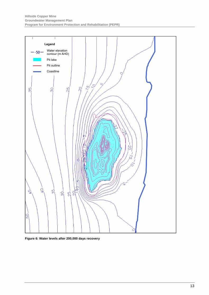
Groundwater modelling has been carried out and indicates that evaporation will result in a pit lake forming in perpetuity. This is documented in the Aldam Geoscience report “DFS Groundwater Investigations Report 130502” (Aldam Geoscience, 2013).
In that report, the potentiometric surface for the basement aquifer 200,000 days (548 years) after the cessation of mining was presented. It is reproduced at Figure 6. A graph of pit water level recovery (the rise of water level in the pit over time) was also presented and is reproduced at Figure 7.
The modelled drawdowns and pit level recovery data presented above (see Figure 5) constitute the baseline dataset for monitoring. To satisfy lease conditions, the monitoring data collected will be compared with these baseline data to assess the validity of modelling and the accuracy of predictions.
0.0
20.0
40.0
60.0
80.0
100.0
120.0
0 1 2 3 4 5 6 7 8 9 10 11 12 13
Disc
harg
e (L
/s)
Stress period (years)
Model discharges
Hillside Copper Mine Groundwater Management Plan Program for Environment Protection and Rehabilitation (PEPR)
13
Figure 6: Water levels after 200,000 days recovery

Hillside Copper Mine Groundwater Management Plan Program for Environment Protection and Rehabilitation (PEPR)
14
Figure 7: Pit water level recovery – water level rise versus time after cessation of mining
5. UNCERTAINTY ASSESSMENT
Key assumptions made in predicting groundwater impacts due to mining at the Hillside Mine and in recommending mitigation and management controls include:
• Mining occurs as scheduled.
• Aquifer hydraulic properties are as used in the model.
• Initial calibration is valid.
• Climate parameters do not change.
• Pit depth and geometry is as specified in the EFS.
• Surface runoff and rainfall occurs as specified in the model.
Of these key assumptions, the greatest uncertainty relates to dot point three ie. initial calibration is valid.

Hillside Copper Mine Groundwater Management Plan Program for Environment Protection and Rehabilitation (PEPR)
15
The Hillside Assessment Report 16 July 2014 states that DEWNR considers that the model used by Rex Minerals is a ‘Class 1’ model according to criteria established in the Australian Model Guidelines, as Rex Minerals has limited data sets to advance to a more complex Class 2 or 3 model. DSD recommends that Rex Minerals acquire additional data during mining operations which would allow ongoing calibration of the groundwater flow model and removal of modelling assumptions.
The actions presented in Table 2 will be taken during the early operational phase to check that these assumptions are satisfactory.
Table 2: Actions to be taken to check groundwater related assumptions during early operations
Assumption Action
Baseline groundwater quality data are representative
Collect groundwater quality data and assess against baseline data
Baseline groundwater levels will decline as predicted by the model
Collect sufficient groundwater depth to water data and compare with baseline data and model predictions
TSF leakage, if any, will be directed toward the pit Monitor seepage flows (water levels, water chemistry), verify TSF (and other) seepage will be captured by the pit
6. KEY RISKS
Potential impact events that DSD has assessed as requiring outcomes are:
• Contamination of groundwater due to open pit mining activities.
• Discharge of contaminated water by excessive leakage through the embankment or base of the TSF.
• Offsite movement of contaminated groundwater from the mine at closure.
• Reduction in groundwater quality for potential future users.
• Discharge of contaminated water through the TSF capping layer, embankment and base.
These are considered to constitute key risks in the context of groundwater.
7. CONTROL MEASURES
7.1 GROUNDWATER QUALITY
Table 5.36 ‘Mine Groundwater Outcome and Measurement Criteria’ of the Rex Minerals document ‘Groundwater Section 5 PEPR’ states the following control and management strategies to protect groundwater quality.
• Storage of fuel, explosives and oil in accordance with EPA and Australian Standards.
• Maintain fuel, oil and explosive storage areas in good operating condition during operations.

Hillside Copper Mine Groundwater Management Plan Program for Environment Protection and Rehabilitation (PEPR)
16
• Undertake regular inspections of areas to ensure integrity of bunded and spill containment areas, housekeeping and correct use of storage and distribution areas.
• Develop and implement fuel management procedures including spill and emergency response and clean up requirements.
• Implement a program to monitor groundwater quality.
• Site inductions to include fuel storage, and spill response and clean-up protocols.
7.2 RSF AND TSF CONTROL MEASURES
Groundwater quality will be protected from potential contaminants entering the aquifers from the waste rock and tailings storage facilities through design as follows:
• PAF material encapsulated in RSF with appropriate separation from base, top and sides of external surface (Section 5.13).
• Store release cover design on the TSF.
• Armouring with inert waste rock.
• Groundwater modelling indicates open pit is a groundwater sink which will capture seepage, hence no impact on existing users (EFS – Appendix 8.4 Groundwater Modelling – Revised Pit Configuration 2015).
• High groundwater salinity precludes the beneficial use apart from industrial purposes (EFS – Appendix 8.4 Groundwater Modelling – Revised Pit Configuration 2015).
• Audit by independent expert confirms closure cover constructed in accordance with approved design.
8. CONSULTATION
This Plan is being prepared in consultation with the Mining Projects Branch of the DPC, the EPA, YP Council, the HMCV consultation group and directly with local landowners.
9. RESPONSE PROCEDURES
9.1 OPERATIONAL RESPONSE PROCESS
Operational response consists of the implementation of the Control Measures outlined in Section 7.
9.2 EXCEEDANCE PROTOCOL
Should groundwater monitoring exceed leading groundwater quality criteria the following actions will be undertaken:
• the Senior Environmental Coordinator will be notified as soon as practicable of any exceedance identified during monitoring;
• the Senior Environmental Coordinator will investigate the results of the individual water quality leading criteria, for the potential causes and identify remedial action;

Hillside Copper Mine Groundwater Management Plan Program for Environment Protection and Rehabilitation (PEPR)
17
• notify the relevant Departmental Manager to cease the activity that could lead to a breach of lease conditions or take appropriate remedial action;
Exceedance of groundwater quality is determined by Conditions 26 and 27 in the Second Schedule of the Hillside Mine ML. That is, “no adverse change to the environmental values of water within the basement fractured rock aquifer”.
9.2.1 Leading groundwater quality criteria
No groundwater dependent ecosystems have been identified nor has any use of this groundwater been reported for agricultural purposes due to its high salinity. Therefore, the leading groundwater quality criteria Conditions 26 and 27 with respect to change to the environmental values is technically satisfied. However, the Hillside Mine will continue to monitor groundwater quality to ensure that the background groundwater quality is not significantly altered during operation (Condition 26) and post operations (Condition 27).
Baseline monitoring of 24 wells (including those shown in Figure 1) for key salinity, pH and metal concentrations are summarised in Table 3. The proposed leading indicators for these key indicators are two successive events that equal or exceed the average plus two times the standard deviation. By definition, the probability of an event exceeding the average plus two standard deviations will only happen 2.23% of the time.
The leading water quality criteria will be updated prior to mining operations. The following leading criteria for each key water quality parameter is provided in Table 3 below:
Table 3: Statistics of Groundwater Quality at the Hillside Mine and Surrounds
STATISTIC Chloride (mg/L) EC (µS/cm)
pH Diss. Arsenic
Diss. Boron
Diss. Cadmium
Diss. Copper
Diss. Zinc
Min 9200 30000 6.2 0.001 1.7 0.0002 0.001 0.002
Max 58000 150000 7.8 0.05 5.5 0.0045 2.8 0.44
Average 21500 63000 7.11 0.01 3.82 0.001 0.244 0.24
AV+ 2SD 47469 127589 5.43* 0.034 6.05 0.002 1.453 0.182
*Many samples had no detectable concentrations of filterable metals, for conservative measures these were reported at the limit of detection. EC is electrical conductivity a measure of salinity. AV+2SD is the average plus two times the standard deviation. Apart from pH which is the average –2 times the standard deviation.
9.3 COMMUNITY RESPONSE PROCESS
Any groundwater issues and/or complaints raised in relation to this Plan will be recorded by Rex Minerals into the site event management database in accordance with the Hillside Mine procedure for complaints. The database will include reporting, incident/event notification, close out action tracking, inspections, and audits.
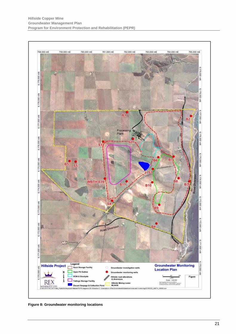
10. MONITORING PROGRAM
Groundwater monitoring is to occur via dedicated groundwater monitoring wells completed in the basement aquifer adjacent to the pit perimeter and also at distance from the pit. It is also to occur via wells completed in the uppermost (unconfined) aquifer near the TSF, the RSF, the decant storage and collection pond, and adjacent to the processing plant.

Hillside Copper Mine Groundwater Management Plan Program for Environment Protection and Rehabilitation (PEPR)
18
The objectives of basement aquifer monitoring are to show no movement of groundwater off the land, to provide data for the ongoing calibration of the transient groundwater model, and to provide information for the ongoing calibration of the pit lake geochemistry and hydrogeological models.
The objectives for the unconfined aquifer monitoring are to assess the magnitude and significance of seepage from the TSF, decant storage and collection pond, and the processing plant, and to demonstrate that seepage if occurring will flow toward the pit.
Depth to water monitoring is to be conducted monthly using an electronic dip-meter and will be carried out by Hillside Mine field staff. Measurements will be from a designated reference point at each well, with the reference point elevation survey levelled to Australian Height Datum (AHD). All depth to water measurements will be converted to elevations AHD and entered into the Rex Minerals monitoring database for use in the calculation of hydraulic gradients and flow paths, and for the identification of water level trends.
For the basement wells, groundwater chemistry will be monitored six monthly through the collection of samples by bailer, low flow sampling or high flow sampling depending on well completion and the availability of water in the well for sample collection. Samples will be sent to a NATA accredited laboratory for analysis under approved transport protocols.
For the unconfined aquifer wells, groundwater chemistry will be monitored a maximum of twice yearly when depth to water measurements indicate the presence of a water column in the monitoring well sufficient for sample collection.
Samples will be collected by bailer, low flow sampling or high flow sampling depending on well completion and availability of water in the well for sample collection. Samples will be sent to a NATA accredited laboratory for analysis under approved transport protocols.
All measurements will be taken by Rex Minerals staff or delegates using Rex Minerals equipment (procured or hired for purpose), with calibration in accordance with the manufacturer’s specifications.
Groundwater sampling equipment will be provided by the analytical laboratory or from established environmental equipment suppliers.
Field measurements will be entered onto the Rex Minerals’ field data sheets and then transferred to Rex monitoring databases or entered directly to databases using field tablet computer or equivalent. Digitally entered data will then be transferred to the Rex monitoring databases for storage and review.
Results of monitoring will be reported as required by the Rex Minerals EMS and regulatory authorities.
Monitoring locations are shown in Figure 8. Summaries of monitoring locations and actions are presented in Table 4 and Table 5. Groundwater will be analysed for general water quality indicators and potential contaminates as outlined in Table 6,
Table 4: Basement aquifer monitoring locations and actions
Site no.
Location Easting (GDA94) Zone 53
Northing (GDA94) Zone 53
Aquifer Monitoring action
Frequency Reason for location
Purpose
B1 Lease boundary north
761781 6177328 Basement Depth to water
Quarterly Lease margin
Flow path, gradient
Groundwater sampling
6 monthly Lease margin
Groundwater quality

Hillside Copper Mine Groundwater Management Plan Program for Environment Protection and Rehabilitation (PEPR)
19
Site no.
Location Easting (GDA94) Zone 53
Northing (GDA94) Zone 53
Aquifer Monitoring action
Frequency Reason for location
Purpose
B2 Lease boundary northeast
764746 6177151 Basement Depth to water
Quarterly Lease margin
Flow path, gradient
Groundwater sampling
6 monthly Lease margin
Groundwater quality
B3 Lease boundary east
764673 6174128 Basement Depth to water
Quarterly Lease margin
Flow path, gradient
Groundwater sampling
6 monthly Lease margin
Groundwater quality
B4 Lease boundary south
763146 6172176 Basement Depth to water
Quarterly Lease margin
Flow path, gradient
Groundwater sampling
6 monthly Lease margin
Groundwater quality
B5 Lease boundary west
759124 6175067 Basement Depth to water
Quarterly Lease margin
Flow path, gradient
Groundwater sampling
6 monthly Lease margin
Groundwater quality
B6 Pit crest northwest
763234 6175243 Basement Depth to water
Quarterly Lease margin
Flow path, gradient
Groundwater sampling
6 monthly Lease margin
Groundwater quality
B7 Pit crest northeast
763939 6175273 Basement Depth to water
Quarterly Lease margin
Flow path, gradient
Groundwater sampling
6 monthly Lease margin
Groundwater quality
B8 Pit crest east 764174 6174274 Basement Depth to water
Quarterly Lease margin
Flow path, gradient
Groundwater sampling
6 monthly Lease margin
Groundwater quality
B9 Pit crest south
763278 6173042 Basement Depth to water
Quarterly Lease margin
Flow path, gradient
Groundwater sampling
6 monthly Lease margin
Groundwater quality
B10 Pit crest west
762955 6174083 Basement Depth to water
Quarterly Lease margin
Flow path, gradient
Groundwater sampling
6 monthly Lease margin
Groundwater quality
B11 TSF – Pit crest west
761766 6174127 Basement Depth to water
Quarterly Extra point between B5 and B10
Flow path, gradient
Groundwater sampling
6 monthly Lease margin
Groundwater quality
Table 5: Unconfined aquifer monitoring locations and actions
Site no.
Location Easting (GDA94) Zone 53
Northing (GDA94) Zone 53
Aquifer Monitoring action
Frequency Reason for location
Purpose
S1 TSF northwest
760680 6175962 Unconfined Depth to water
Quarterly TSF seepage
Flow path, gradient
Groundwater sampling
6 monthly if water present
TSF seepage
Groundwater quality
S2 TSF northeast
762060 6176095 Unconfined Depth to water
Quarterly TSF and process
Flow path, gradient

Hillside Copper Mine Groundwater Management Plan Program for Environment Protection and Rehabilitation (PEPR)
20
Site no.
Location Easting (GDA94) Zone 53
Northing (GDA94) Zone 53
Aquifer Monitoring action
Frequency Reason for location
Purpose
plant seepage
Groundwater sampling
6 monthly if water present
TSF and process plant seepage
Groundwater quality
S3 Decant pond
762985 6174700 Unconfined Depth to water
Quarterly Decant pond seepage
Flow path, gradient
Groundwater sampling
6 monthly if water present
Decant pond seepage
Groundwater quality
S4 TSF south 761091 6173232 Unconfined Depth to water
Quarterly TSF seepage
Flow path, gradient
6 monthly if water present
TSF seepage
Groundwater quality
S5 Lease boundary west
759403 6175038 Unconfined Depth to water
Quarterly Background Flow path, gradient
6 monthly if water present
Background Groundwater quality
Table 6: Groundwater analyte list
Cations and anions Calcium, Magnesium, Potassium, Sodium, Sulphate, Chloride, Nitrate
Salinity Electrical conductivity (EC), total dissolved solids (TDS)
Acidity pH
Hydrocarbons Total recoverable hydrocarbons (TRH) – site S2 (processing plant) only
Metals Arsenic, Boron, Chromium, Cobalt, Copper, Iron, Manganese, Zinc, Antimony, Uranium
Hillside Copper Mine Groundwater Management Plan Program for Environment Protection and Rehabilitation (PEPR)
21
Figure 8: Groundwater monitoring locations

Hillside Copper Mine Groundwater Management Plan Program for Environment Protection and Rehabilitation (PEPR)
22
11. REPORTING
Reporting is designed to evaluate compliance with the Hillside Mine ML conditions, and to provide stakeholder access to relevant groundwater information and data.
Key stakeholders requiring access to this information include Rex Minerals, state and local government agencies, and the local community.
The Hillside Mine will report on the performance of the GMP in the ACR and provide regular updates to members of the HMCV consultation group. The ACR will be provided to the HMCV and made available for public information on the Rex Minerals website.
12. PERFORMANCE INDICATORS
The following performance indicators will be measured against the ML conditions:
• zero seepage and water mounding beneath the TSF, decant seepage and collection pond;
• zero leakage from tanks and chemical storages to the unconfined aquifer;
• the movement of any waters in the unconfined aquifer beneath the TSF, decant seepage and collection pond, tanks and chemical storages is toward the pit;
• the transitioning of the flow path in the basement aquifer from its current west to east direction to radial toward the pit as the pit gets deeper and dewatering occurs.
13. CONTINUAL IMPROVEMENT
Rex Minerals will strive to continually improve on the Hillside Mine’s environmental performance by applying the principles of best practice to mining operations, including where cost-effective and practicable, the adoption of new best practice technologies and improved quality control measures. Progress will be monitored using the above noted performance indicators.
14. REVIEW
This Plan will be reviewed, and if necessary revised, to the satisfaction of the Mining Projects Branch of the DPC and in consultation with relevant government agencies, in accordance with the requirements relating to PEPR review, update and approval:
• following changes to project approval or licence conditions relating to mining operations, water management or monitoring;
• following any significant groundwater related incident;
• when a relevant/significant improvement has been identified;
• for necessary or any unforeseen changes to groundwater monitoring locations;
• where a risk assessment identifies the requirement to alter the Plan;
• annually.

Hillside Copper Mine Groundwater Management Plan Program for Environment Protection and Rehabilitation (PEPR)
23
15. REFERENCES
Aldam Geoscience, 2015 “January 2015 modelling and salinity 150128”
Aldam Geoscience, 2013 “DFS Groundwater Investigations Report 130502”
EFS – Appendix 8.4 Groundwater Modelling – Revised Pit Configuration 2015
The Hillside Assessment Report 16 July, 2014
DEWNR Waterconnect database (https://www.waterconnect.sa.gov.au)
International Standard 14001:2004 Environmental Management Systems

Hillside Copper Mine Groundwater Management Plan Program for Environment Protection and Rehabilitation (PEPR)
24
16. APPENDICES
Appendix 1: Correspondence Records
Key relevant communications with the Mining Projects Branch of the DPC, YP Council and the community relating to this management plan are detailed below.
Date Communication with Action or Outcomes
31/07/2017 DPC Draft sent to DPC
31/07/2017 HMCV Draft uploaded to the HMCV website

Hillside Copper Mine Groundwater Management Plan Program for Environment Protection and Rehabilitation (PEPR)
25
Appendix 2: Groundwater Management Plan Requirements Checklist Condition Requirement Section
Rex Minerals Hillside Mine Mineral Lease Conditions (ML 6438) Second Schedule
Groundwater
26. The Tenement Holder must ensure there is no adverse change to the environmental values of water within the basement fractured rock aquifer outside of the Land as a result of mining operations.
2, 4,7, 10,11
27. The Tenement Holder must ensure there is no adverse change to the environmental values of the basement fractured rock aquifer within or outside of the Land as a result of mining operations after mine completion.
2, 4, 7, 10,11
28. The Tenement Holder must obtain approval from the Director of Mines in writing before developing any:
N/A
28.1. Groundwater cut-off wellfield; or
28.2. MAR.
Rex Minerals Hillside Mine Mineral Lease Conditions (ML 6438) Sixth Schedule
Groundwater Strategies
31. The Tenement Holder must provide a calibrated ground water model in the proposed PEPR. 2, 4, 10, 12
32. The Tenement Holder must establish a program for the establishment and ongoing calibration of the transient ground water model using data obtained from groundwater monitoring within the PEPR.
2, 4, 10, 12
33. The Tenement Holder must provide a calibrated transient groundwater model within 1 year from the approval of the PEPR.
2, 4, 10, 12.
34. The Tenement Holder must establish a program for the ongoing calibration of the pit lake geochemistry and hydrogeological models using data obtained from operational monitoring to address any assumptions and uncertainty within the model.
2, 4, 10, 12
Groundwater Criteria
35. The Tenement Holder is required to address the following matters for the purposes of Regulation 65(2)(d) of the Regulations in relation to the Second Schedule Conditions 26 and 27:
35.1. Establish representative baseline water quality data for the basement fractured rock aquifer underlying the Land.
2, 4 & Table 6 Groundwater Report

Hillside Copper Mine Groundwater Management Plan Program for Environment Protection and Rehabilitation (PEPR)
26
35.2. Establish compliance groundwater monitoring bores adjacent to the lease boundaries that are of sufficient density and depth to detect movement of groundwater off the Land.
2, 4, 7, 10
Condition Requirement Section
Rex Minerals Hillside Mine Mineral Lease Conditions (MPL 146) Second Schedule
Groundwater
5. The Tenement Holder must ensure there is no adverse change to the environmental values of the groundwater within the shallow Cainozoic age sediments outside of the Land as a result of site operations.
2, 4, 7, 10, 11
6. The Tenement Holder must ensure there is no adverse change to the environmental values of the groundwater within the shallow Cainozoic age sediments within or outside of the Land after mine completion.
2, 4, 7, 10, 11
No mine related infrastructure is going to be placed underground, therefore there will be no impacts to groundwater.
Condition Requirement Section
Rex Minerals Hillside Mine Mineral Lease Conditions (MPL 146) Sixth Schedule
Groundwater
9. The Tenement Holder is required to address the following matters for the purposes of Regulation 65(2)(c) of the Regulations in relation to the Groundwater Outcome Schedule 2 - Condition 5;
9.1 design and management strategies are to be provided for pipeline leak detection which includes automation of operational controls for the monitoring and control of all pipelines on the related Mineral Lease and this Mining Tenement. This should include (but is not limited to);
9.1.1 continuous and automatic monitoring of pressures, flow rates and any other parameters for the prompt detection and resolution of abnormal operating conditions in any pipeline or processing plant equipment;
N/A
9.1.2 continuous and automatic monitoring of process plant functions, including tank levels, flow rates, pressures and fluid quantities;
9.1.3 the integration of data through a central computer-based control and monitoring system
No mine related infrastructure is going to be placed underground, therefore there will be no impacts to groundwater.