groundwater in china - ecoinnovation.dk groundwater in china_part 1_occurrence...viii groundwater in...
TRANSCRIPT
APRIL 2013
NATURE AGENCY
MINISTRY OF THE ENVIRONMENT
GROUNDWATER IN CHINA PART 1 - OCCURRENCE AND USE


APRIL 2013
NATURE AGENCY
MINISTRY OF THE ENVIRONMENT
GROUNDWATER IN CHINA PART 1 - OCCURRENCE AND USE
ADDRESS COWI
Parallelvej 2
2800 Kongens Lyngby
Denmark
TEL +45 5640 2211
WWW COWI.COM
PROJECT NO. 31357
DOCUMENT NO. 1
VERSION 2
DATE OF ISSUE 18 June 2013
PREPARED Lars Skov Andersen
CHECKED Xu Yi, Lei Dai, Xu Zhengyang
APPROVED Jesper Karup Petersen


GROUNDWATER IN CHINA
PART 1 - OCCURRENCE AND USE
C:\Users\LSA\Documents\2 CEWP Groundwater 31357\130618 Groundwater in China_Part 1_Occurrence and Use.docx
v
CONTENTS
Summary and Recommendations vi
1 Introduction 1
2 Occurrence, availability and utilisation of groundwater in China 3
2.1 Occurrence 3
2.2 Water resources 5
2.3 Water utilisation 6
3 Challenges and Solutions 9
3.1 Groundwater abstraction and use 10
3.2 Groundwater quality 14
3.3 Groundwater mapping and resource assessment 17
3.4 Fragmented management 18
3.5 Regulation of groundwater abstraction 20
4 Key policies, strategies and actions 27
4.1 China 2011 No.1 Document 27
4.2 Three Red Lines Strategy 28
4.3 2004-2015 Water Action Programme 30
4.4 2011-2020 groundwater pollution prevention
plan 32
4.5 New national monitoring programme 32
5 Conclusions 33
6 References 35
Appendix A Regional characteristics 39
A.1 Liao-Songhua lowland 39
A.2 North China Plain 41
A.3 Coastal areas and estuaries 46
A.4 Huai River Floodplain 49
A.5 Yangtze Flood Plain 50
A.6 South China Karst 50
A.7 Sichuan Basin 51
A.8 Northwest Deserts 52
Appendix B Schedule for water allocation 57
VI GROUNDWATER IN CHINA
PART 1 - OCCURRENCE AND USE
C:\Users\LSA\Documents\2 CEWP Groundwater 31357\130618 Groundwater in China_Part 1_Occurrence and Use.docx
Summary and Recommendations
Preamble
“Since there is approximately 100 times more groundwater on Earth than fresh
surface water, it makes sense to exploit groundwater as a source of water. In many
parts of the world, especially in arid or seasonally dry regions, groundwater can
provide a stable and sustainable source of high quality water” (Klee, 2013).
Since “Denmark has probably the best groundwater management in the World”1 it
makes even more sense to look to Denmark for groundwater solutions, where a
sustainable use of groundwater has been achieved in response to strict government
management, although Denmark relies 100% on groundwater for its entire supply
of water be it domestic, industrial or agricultural water uses.
The Danish solutions also apply to China, although the scales are vastly different
and north and south China that present widely different groundwater scenarios. In
the dry northern and north-western parts of China groundwater resources already
suffer from unsustainable abstraction over large areas, while the groundwater
potential in the humid southern parts not yet is fully developed.
Part 1 Occurrence and Use
China has 8 hydro-geological regions, where groundwater is important for rural,
urban and industrial water supply:
1 Liao-Songhua Lowland
2 North China Plain
3 Coastal areas of the North China Plain, Shandong Peninsula, Huai River
Floodplain and the Yangtze River Estuary
4 Huai River Floodplain
5 Yangtze Floodplain and River Valley
6 South China Karst
7 Sichuan Basin
8 North-West Deserts.
1 Transcribed from a slogan promoting Carlsberg in South East Asia
GROUNDWATER IN CHINA
PART 1 - OCCURRENCE AND USE
C:\Users\LSA\Documents\2 CEWP Groundwater 31357\130618 Groundwater in China_Part 1_Occurrence and Use.docx
vii
Key issues in groundwater management and use in China are:
› Fragmented management
› Unsustainable abstraction in northern China
› Salinity intrusion along the coast
› Soil and groundwater pollution
› Dewatering of mines and construction sites
› Low use of groundwater in karst areas in south-western China.
Three principal impacts of high groundwater abstraction are:
› Declining yields in northern China placing agriculture and industry at risk
› Land subsidence, especially in coastal areas, raising the risk of flooding and
incurring high costs of subsurface infrastructure repair
› Deteriorating quality, including intrusion of seawater and release of salts and
metals from soils within depression cones.
Groundwater management is fragmented across several ministries, of which
Ministry of Water Resources, Ministry of Land and Resources, Ministry of
Environmental Protection and Ministry of Housing, Urban and Rural Development
are the key players.
In principle groundwater abstraction is subject to licensing and permitting by
Ministry of Water Resources and its line agencies at province2, municipal, city and
county levels, but in practice licensing is at a very early stage.
High abstraction in northern China has locally led to groundwater levels declining
by up to 1 m per year since 1960 and now poses a serious risk to water supply
security for all sectors. The areas most affected are 1) the North China Plain around
Beijing and Tianjin within the Hai River Basin, 2) the Liao-Songhua Lowland and
3) the Northwest Deserts (Hexi Corridor) along the Silk Road in Gansu Province.
On the flood plains and along the coast declining groundwater levels lead to land
subsidence, which in urban areas results in high costs for maintenance and repair of
underground infrastructure, especially Tianjin and Shanghai are affected, but land
subsidence also affects surface infrastructure such as the high-speed train network.
Salinity intrusion mainly takes place along the coast, including Tianjin, North
China Plain, Shandong and Jiangsu Provinces, where high groundwater abstraction
leads to intrusion of sea water, but it may also occur under the flood plains, where
saline and freshwater aquifers alternate, resulting in up-welling of saline water in
case of heavy abstraction.
2 “Provinces” is used as the general term including municipalities directly under central government,
for instance Chongqing, and autonomous regions, for instance Xinjiang.
VIII GROUNDWATER IN CHINA
PART 1 - OCCURRENCE AND USE
C:\Users\LSA\Documents\2 CEWP Groundwater 31357\130618 Groundwater in China_Part 1_Occurrence and Use.docx
Groundwater is a source of urban water supply in 400 of Chinese cities and 60% of
these cities report moderate to significant pollution of the groundwater.
Dewatering of mines and construction sites leads to serious depletion of local
groundwater resources and are now subject to hydro-geological modelling as
decision support for project approval. Mining of coal takes place almost throughout
China, while mining of minerals is particularly important in Gansu, Inner Mongolia
and Xinjiang Provinces in the Northwest Deserts. More than half of China’s
industrial water use is in coal related industry, from dewatering of mines, through
processing, to cooling of coal-fired power plants3.
The South China Karst in Guizhou and Yunnan is widely considered as a dry
region, although many rivers spring in the karst area indicating the opposite. The
perception is probably due to a combination of rapid infiltration of surface water
and inadequate technology for identification and abstraction of groundwater in
karst areas.
Potential solutions to the key issues include:
› Better governance, including institutional coordination and collaboration,
integrated surface and groundwater management planning and a broader range
of demand management tools in addition to the mainly administrative
measures in use today
› Inter-basin transfers, especially the South-to-North Water Transfer, which is
regarded as the “silver bullet” solving water shortages and offering a unique
opportunity for groundwater recovery on the North China Plain
› Introduction of new or modernised technology, including:
› Modern geophysical groundwater survey technology
› Modern hydro-geological modelling tools for groundwater resource
assessment and abstraction strategies
› Groundwater monitoring technology
› Efficient and self-regulating submersible pumps reducing power
consumption and the risk of borehole damage due to excessive
abstraction
› Groundwater treatment technologies, especially for brackish and polluted
groundwater
› Water saving technologies, including leakage detection and water saving
equipment and appliances in households, industry and agriculture
› Institutional capacity building enabling application and use of new technology.
3 http://chinawaterrisk.org/notices/clsa-water-for-coal-thirsty-miners-will-share-the-pain/

GROUNDWATER IN CHINA
PART 1 - OCCURRENCE AND USE
C:\Users\LSA\Documents\2 CEWP Groundwater 31357\130618 Groundwater in China_Part 1_Occurrence and Use.docx
ix
Part 2 Market Analysis
China should not be seen as one, but as multiple markets, including 4 principal
ministries at central level, 32 provinces and 65 cities and towns with more than 1
million inhabitants.
Entry into the market is best led by government to government exchange
promoting the Danish groundwater management model raising awareness on the
complementary roles and capacities of the government and private sector.
A multi- criteria assessment of the groundwater market in China identifies 4
geographic areas as priorities for Danish business development:
1 Nationally via Ministry of Water Resources and Ministry of Land and
Resources
2 Coastal areas including Shandong and Tianjin
3 North China Plain, including Beijing, Tianjin and Hebei
4 Huai River Basin, mainly Southwest Shandong and North Jiangsu
Inclusion of additional water sector interests than groundwater may shift the focus
for overall promotion of the Danish water sector in China.
The Ministry of Water Resources has identified Shandong Province as the priority
area in Chinese perspective, because the province represents three key groundwater
challenges and in addition is open to foreign involvement and investment:
› Restoration of depleted groundwater aquifers on the North China Plain
› Mitigation of seawater intrusion in coastal areas
› Protection of groundwater dependent eco-systems.
Cross-cutting observations arising from this study may be summarised in five
recommendations. These five recommendations are based on the size of the
Chinese market, which for the majority of Danish companies China provides more
than 100 potential markets with larger business potential than Denmark.
Focus - is the first key to marketing of Danish know-how, software and technology
in China.
Partnership - is the second key. A Chinese partner is essential for most Danish
companies to enter the Chinese market, and it is important to base this partnership
on mutual interest, mutual benefit and mutual finance – the slogan of the China
Europe Water Partnership.
Production in China - is the third key that may require downscaling of Danish
solutions to be technically and financially appropriate for production and sale in
China.

X GROUNDWATER IN CHINA
PART 1 - OCCURRENCE AND USE
C:\Users\LSA\Documents\2 CEWP Groundwater 31357\130618 Groundwater in China_Part 1_Occurrence and Use.docx
Integrated or one-stop solutions - is the fourth key to match the Chinese market,
which has a tradition for turn-key solutions without separate technical or
management assistance.
Coordination among Danish companies - is the final key for effective marketing
of Danish solutions in China, which are of sufficient size and diversity that a
coordinated approach will be beneficial for all.

GROUNDWATER IN CHINA
PART 1 - OCCURRENCE AND USE
C:\Users\LSA\Documents\2 CEWP Groundwater 31357\130618 Groundwater in China_Part 1_Occurrence and Use.docx
1
1 Introduction
The Nature Agency of the Danish Ministry of the Environment, which hosts the
EU Secretariat of the China Europe Water Platform, has contracted COWI to
contribute to a market analysis of the demand for groundwater know-how and
technology in China.
The market analysis is structured in 3 parts:
Part 1: Groundwater occurrence and use
Part 2: Market survey focusing on Danish competencies
Part 3: Relation building and business development for promotion of Danish
Export
The purpose of the market analysis is:
› to provide an overview of groundwater resources and their significance,
management and use in China (Part 1)
› within selected provinces to identify organisations and individuals, who could
be the target group for business-to-business development (Part 2)
› to build business relations with the target group through meetings, workshops
conferences, study tours, pilot projects and research (Part 3 to be carried out
by the Danish Trade Council with assistance from COWI).
The review of groundwater resources shall include:
› Description of regions and provinces based on the significance of the
groundwater resources, current utilisation and trends in groundwater
exploitation
› Unsustainable exploitation of groundwater
› Groundwater monitoring
› Government regulation of groundwater abstraction.
2 GROUNDWATER IN CHINA
PART 1 OCCURRENCE AND USE
C:\Users\LSA\Documents\2 CEWP Groundwater 31357\130618 Groundwater in China_Part 1_Occurrence and Use.docx
The target provinces shall be identified based on:
› recognised demand for solutions to water challenges
› local political willingness and interest in adopting new technology
› drivers and pricing structures supporting a dynamic market
› budgets allocated for water sector investment
› openness to international cooperation within local government, research
institutions and the private sector
› existing relations with Denmark.
Part 1: Groundwater occurrence and use
Part 1 is structured as follows:
Chapter 1 Introduction
Chapter 2 Description of the occurrence and utilisation of groundwater in China
Chapter 3 Identification and description of key issues in groundwater
management, protection and utilisation in China
Chapter 4 Key government policies significant to groundwater management
Chapter 5 Conclusions
Appendix A Description of the occurrence and utilisation of groundwater in each
of the 8 groundwater regions.
Part 2 Market analysis in a Danish perspective
Chapter 1 Introduction
Chapter 2 Groundwater occurrence and use (Summary)Market information and
analysis
Chapter 3 Market place
Chapter 4 Market services
Chapter 5 Geographic priority areas
Appendix A-C Population in urban areas
Appendix D Contact information

GROUNDWATER IN CHINA
PART 1 - OCCURRENCE AND USE
C:\Users\LSA\Documents\2 CEWP Groundwater 31357\130618 Groundwater in China_Part 1_Occurrence and Use.docx
3
2 Occurrence, availability and utilisation
of groundwater in China
2.1 Occurrence
Groundwater is a significant resource for all major water uses, including rural,
urban, industrial and agricultural water supply throughout China, however, for
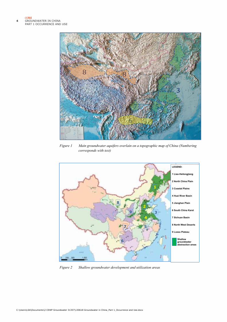
descriptive purposes 8 principal hydro-geological regions may be distinguished.
Clockwise starting from north-east China these are (Figure 1):
5 Liao-Songhua River Valleys
6 North China Plain (Hai River Floodplain)
7 Coastal areas of the North China Plain, Shandong Peninsula, Huai River
Floodplain and the Yangtze River Estuary
8 Huai River Floodplain
9 Yangtze Floodplain and River Valley
10 South China Karst
11 Sichuan Basin
12 North-West Deserts
All regions, except the South China Karst, have alluvial gravel and sand aquifers,
which underlie large areas, potentially have very high yields and are used
extensively (Figure 2). The South China Karst is a fractured limestone aquifer with
very uneven groundwater potential.
The characteristics of each region are described in Appendix A.
4 GROUNDWATER IN CHINA
PART 1 OCCURRENCE AND USE
C:\Users\LSA\Documents\2 CEWP Groundwater 31357\130618 Groundwater in China_Part 1_Occurrence and Use.docx
Figure 1 Main groundwater aquifers overlain on a topographic map of China (Numbering
corresponds with text)
Figure 2 Shallow groundwater development and utilization areas
1
8 8
7
2
4
3
5
6
LEGEND:
1 Liao-Heilongjiang
2 North China Plain
3 Coastal Plains
4 Huai River Basin
5 Jianghan Plain
6 South China Karst
7 Sichuan Basin
8 North West Deserts
9 Loess Plateau
Shallow groundwater
abstraction areas
1
3
2
4
5 7
8
9
6

GROUNDWATER IN CHINA
PART 1 - OCCURRENCE AND USE
C:\Users\LSA\Documents\2 CEWP Groundwater 31357\130618 Groundwater in China_Part 1_Occurrence and Use.docx
5
2.2 Water resources
Hydrologically China is divided into a northern region with relatively low rainfall
(≤ 650 mm) and corresponding low groundwater recharge, making the alluvial
aquifers extremely vulnerable to over-abstraction, while the southern regions have
ample rainfall, especially along the coast and in the Himalaya Mountains. The
hydrological boundary between north and south China roughly follows the water
divide between the Yellow River Basin and the Yangtze River Basins (Figure 3).
Figure 3 The main groundwater regions of China overlain on a rainfall map
Rainfall, however, is highly seasonal with 70% - 80% falling during summer, when
evaporation is high thus reducing the available water resource to half and severely
reducing the recharge of groundwater in north China.
The available water resources are estimated at 3,100 billion m3, of which the
groundwater resource is estimated at 840 billion m3. This number is derived as the
sum of river base-flow and groundwater abstraction (Table 1). The actual
groundwater resource may be higher due to incomplete registration of abstractions,
whereas the renewable resources may be lower due to high and unsustainable
abstraction in many areas of north China.

6 GROUNDWATER IN CHINA
PART 1 OCCURRENCE AND USE
C:\Users\LSA\Documents\2 CEWP Groundwater 31357\130618 Groundwater in China_Part 1_Occurrence and Use.docx
Table 1 Rainfall and water resources availability (billion m3)
Rainfall Surface
Water
Groundwater
Seepage
Groundwater
Abstraction
Total
North China 2,215 510 175 95 605
South China 4,370 2,470 555 15 2,485
Total 6,585 2,980 730 110 3,090
Climate change is beginning to show an impact. In the upper reaches of the Yellow
River Basin rainfall is predicted to fall by up to 15%, but otherwise the impact is
mainly in terms of more intense local rainfall alternating with longer dry spells.
The increase in rainfall intensity is creating new demands for increased flood
protection and China is slowly realising that traditional approaches to flood control
by increasing water storage in dams or building river dikes for rapid conveyance of
water to the sea are detrimental to the water balance and that strategies for keeping
water in the landscape need to be adopted to increase groundwater recharge.
2.3 Water utilisation
Groundwater abstraction
The current water use in China is estimated at 600 billion m3, of which the known
groundwater abstraction constitutes 110 billion m3 (Figure 4), although the 2010
Groundwater Action Plan indicates the actual abstraction to be up to 150 billion m3
(MWR, 2010).
Figure 4 Historical development of groundwater abstraction 1972 - 2010
The groundwater abstraction mainly takes place from shallow aquifers on the
plains and inland deserts in north China (Figure 5), where steadily declining
groundwater levels indicate a serious over-abstraction (Appendix A), while there is
substantial room for increase of groundwater utilisation in south China.
0
25
50
75
100
125
1972 1975 1980 1985 1990 1995 2000 2005 2010
bil
lio
n m
3/y
ea
r
Groundwater Abstraction
GROUNDWATER IN CHINA
PART 1 - OCCURRENCE AND USE
C:\Users\LSA\Documents\2 CEWP Groundwater 31357\130618 Groundwater in China_Part 1_Occurrence and Use.docx
7
Figure 5 Groundwater abstraction in 2010 by type of aquifer, landform and region
Sector use
Groundwater is mainly used in agriculture (~60%), while domestic and industrial
uses each account for about 20% (Figure 6).
The use of a large proportion of groundwater in agriculture should be the cause of
serious concern. Firstly, most of this water is used for irrigation of wheat, maize,
cotton and soya beans, which give a low financial and economic return on water
(Xu et al., 2005). Secondly, the abstraction over large parts of northern China is not
sustainable, hence continued excessive abstraction places 15% of China’s food
production at risk severely conflicting with the Chinese food security policy (Li,
2010).
Figure 6 Sector use of groundwater in 2010
Although the utilisation for domestic purposes is relatively low, the amount of
around 20 billion m3/year would be sufficient to supply 600 million people with
100 litres/capita/day, for instance the entire rural population of China. A significant
part of the domestic consumption, however, is used for urban water supply, where
a recent report (MWR and MLR, 2010) indicates that 400 out of 650 large cities
use groundwater sources for their water supply (Figure 7) and that groundwater
Deep
aquifers
Shallow
aquifers
0
25
50
75
100
125
bil
lio
n m
3Mountains
Plains
South
North
Domestic
IndustryAgriculture

8 GROUNDWATER IN CHINA
PART 1 OCCURRENCE AND USE
C:\Users\LSA\Documents\2 CEWP Groundwater 31357\130618 Groundwater in China_Part 1_Occurrence and Use.docx
provides 60%-70% of the urban water supply in northwest and north China,
respectively4. The report also states that groundwater is polluted in 90% of these
cities and seriously polluted in 60% of them, thus stressing the importance of
protecting groundwater recharge areas against potentially polluting activities.
Figure 7 Significance of groundwater in urban water supply (Hui, 2012)
4 The comprehensive use in urban areas suggests that a large part of the small scale
abstractions for rural water supply may not be included in the groundwater resource
estimate.
GROUNDWATER IN CHINA
PART 1 - OCCURRENCE AND USE
C:\Users\LSA\Documents\2 CEWP Groundwater 31357\130618 Groundwater in China_Part 1_Occurrence and Use.docx
9
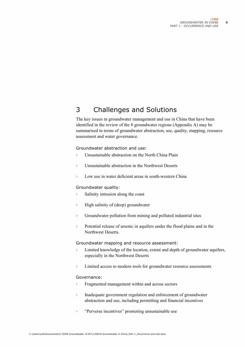
3 Challenges and Solutions
The key issues in groundwater management and use in China that have been
identified in the review of the 8 groundwater regions (Appendix A) may be
summarised in terms of groundwater abstraction, use, quality, mapping, resource
assessment and water governance.
Groundwater abstraction and use:
› Unsustainable abstraction on the North China Plain
› Unsustainable abstraction in the Northwest Deserts
› Low use in water deficient areas in south-western China
Groundwater quality:
› Salinity intrusion along the coast
› High salinity of (deep) groundwater
› Groundwater pollution from mining and polluted industrial sites
› Potential release of arsenic in aquifers under the flood plains and in the
Northwest Deserts.
Groundwater mapping and resource assessment:
› Limited knowledge of the location, extent and depth of groundwater aquifers,
especially in the Northwest Deserts
› Limited access to modern tools for groundwater resource assessments
Governance:
› Fragmented management within and across sectors
› Inadequate government regulation and enforcement of groundwater
abstraction and use, including permitting and financial incentives
› “Perverse incentives” promoting unsustainable use
10 GROUNDWATER IN CHINA
PART 1 OCCURRENCE AND USE
C:\Users\LSA\Documents\2 CEWP Groundwater 31357\130618 Groundwater in China_Part 1_Occurrence and Use.docx
› Economically inefficient use
› Inadequate understanding of the interaction of surface and groundwater
› Long delays in application of research in government management.
3.1 Groundwater abstraction and use
The key issue in groundwater management and use in China is the unsustainable
abstraction of groundwater that has taken place in northern China during the past
50 years causing deep drawdowns of the groundwater levels over large areas of the,
the Liao-Songhua lowland, the North China Plain and the Northwest Deserts.
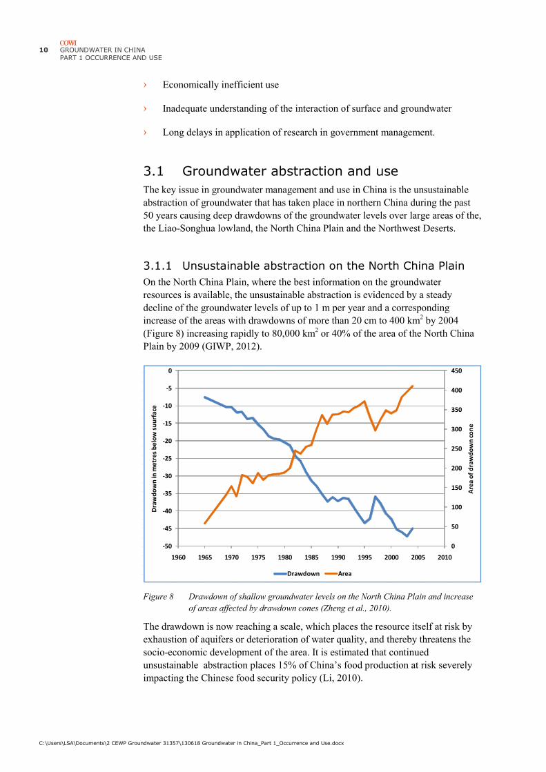
3.1.1 Unsustainable abstraction on the North China Plain
On the North China Plain, where the best information on the groundwater
resources is available, the unsustainable abstraction is evidenced by a steady
decline of the groundwater levels of up to 1 m per year and a corresponding
increase of the areas with drawdowns of more than 20 cm to 400 km2 by 2004
(Figure 8) increasing rapidly to 80,000 km2 or 40% of the area of the North China
Plain by 2009 (GIWP, 2012).
Figure 8 Drawdown of shallow groundwater levels on the North China Plain and increase
of areas affected by drawdown cones (Zheng et al., 2010).
The drawdown is now reaching a scale, which places the resource itself at risk by
exhaustion of aquifers or deterioration of water quality, and thereby threatens the
socio-economic development of the area. It is estimated that continued
unsustainable abstraction places 15% of China’s food production at risk severely
impacting the Chinese food security policy (Li, 2010).
0
50
100
150
200
250
300
350
400
450
-50
-45
-40
-35
-30
-25
-20
-15
-10
-5
0
1960 1965 1970 1975 1980 1985 1990 1995 2000 2005 2010
Are
a o
f d
raw
do
wn
co
ne
Dra
wd
ow
n in
me
tre
s b
elo
w s
uu
rfa
ce
Drawdown Area
GROUNDWATER IN CHINA
PART 1 - OCCURRENCE AND USE
C:\Users\LSA\Documents\2 CEWP Groundwater 31357\130618 Groundwater in China_Part 1_Occurrence and Use.docx
11
The drawdown results in deteriorating groundwater quality due to:
› Upwelling of saline water from deeper aquifers
› Oxidation and leaching of salts from sediments within the depression cones
› Release of arsenic and other “metals” by oxidation of organic sediments
within the depression cones.
The drawdown also results in:
› Land subsidence
Land subsidence is most severe towards the coast, where clay and organic
sediments dominate. In Beijing an area of 3,000 km2 has subsided more than 5 cm
and some areas by up to 1 m, while subsidence up to 3 m is reported from Tianjin.
The costs of land subsidence in urban areas is estimated at 200 million RMB per
mm subsidence mainly for repair of subsurface infrastructure (Wang, 2009), of
which a significant part is water pipes and sewers.
Solutions
Though adequate knowledge of the groundwater resources under the North China
Plain and the implications of the over-abstraction has been generated in a string of
scientific reports and articles starting from 1989 (Liu and Wei, 1989) and
delivering increasingly clear evidence and recommendations on the need for
adjustment of agricultural policies and cropping patterns (Xu et al., 2005), very
few, if any, of these recommendations have been translated into action. A likely
cause is the fragmentation of government management since most of this
information was generated in the agricultural sector, where action would conflict
with national policies for provincial and national self-sufficiency in food
production.
Solutions to the excessive abstraction will require almost the entire range of water
management measures, including both supply and demand management. The
proposed measures will be described in Chapters 3.3 and 3.4.
The main solution that China has embarked on is the South-to-North Water
Transfer Project (SNWTP), which will transfer water from the Yangtze River
Basin to the North China Plain (Figure 9). The east and central routes are expected
to come into operation in 2014 and are designed to deliver 28 billion m3 per year
when in full operation by 2020. Their main purpose is strategic water security for
the future Beijing – Tianjin Metropolis with 50 million people, but all cities and
counties along the route and on the North China Plain see the project as the “silver
bullet” to current water shortages and future growth. In this context it is worth
noticing that the annual groundwater abstraction on the North China Plain is
estimated at 18 billion m3 or 65% of the full capacity of the SNWTP. On top of this
comes the increased urban and industrial water supply and environmental demands
to restore the groundwater and the flow of the Hai River. The SNWTP offers a
unique opportunity to restore the groundwater resources under the North China
Plain provided it is coupled with additional demand side solutions to arrive at a
sustainable utilisation.

12 GROUNDWATER IN CHINA
PART 1 OCCURRENCE AND USE
C:\Users\LSA\Documents\2 CEWP Groundwater 31357\130618 Groundwater in China_Part 1_Occurrence and Use.docx
Figure 9 Routes of the South-to-North Water Transfer
The measures already taken by several provinces and counties include closure of
groundwater wells. In Beijing, for instance, the Beijing Water Authority, which
was established in 2004, has issued a ban on groundwater abstraction inside the 4th
ring-road (BWA, 2012) in order to halt land subsidence.
3.1.2 Unsustainable abstraction in the Northwest Deserts
Challenges
The Northwest Deserts are vast inland depressions surrounded by the northern
branches of the Himalaya Mountains and filled with layers of gravel and sand
washed out from the rising mountains. Water resources are generated by rainfall
and snowmelt in the mountains, where annual rainfall is 600-800 mm gradually
falling to less than 50 mm in the deserts.
The Silk Road follows the foothills of the Qilian Mountains also known as the
Western Rivers Corridor (Hexi Corridor), where rivers, springs and oases formed
the stepping stones for ancient caravans.
From East to West a number of small inland rivers, including the Shiyang, Hei,
Beida, Changma and Shule Rivers, rise in the mountains and flow across the
alluvial plains to dry out in inland deltas, swamps, salt marshes or shallow lakes in
the desert.
Substantial land development for agriculture started in the 1950s to resettle the
population from the Loess Plateau, which at the time was housing some of the
poorest people of China. Agricultural development was based on the scarce surface
water resources using traditional lowland technology of reservoirs and lined
irrigation canals with little consideration of the intense evaporation of up to 2000
mm from reservoirs and canals and the interaction of surface and groundwater
resources (Oelert and Rosbjerg, 2005a).

GROUNDWATER IN CHINA
PART 1 - OCCURRENCE AND USE
C:\Users\LSA\Documents\2 CEWP Groundwater 31357\130618 Groundwater in China_Part 1_Occurrence and Use.docx
13
Rapid exhaustion of the surface water resources made farmers turn to groundwater,
which was readily available in the alluvial deposits along the mountains, along the
rivers and in the oases in the deserts, but the reduced recharge slowly depleted the
groundwater resources, too.
The results have been a steady decline of groundwater levels, drying out of the
shallow groundwater, increased salinity of shallow aquifers and increasing use of
deep aquifers.
The impacts include withering of the already sparse desert vegetation opening for
increased desertification and sandstorms, which in extreme cases reach the area
around Beijing. Farmers, who originally used groundwater as secure supply during
seeding and early stages of growth, have had to switch to surface water and instead
use increasing amounts of groundwater for bulk irrigation as crops grow more
mature and less sensitive to salinity.
Domestic water supply has also been affected and is now taking place from few
deep wells, where the population have to fetch their domestic water (Figure 10).
Figure 10 Groundwater well and women and children carting water in Minqin
Solutions
The groundwater resources of the Northwest Deserts are poorly known. Better
knowledge might open for an increased use in some areas combined with measures
to reduce water use in areas with unsustainable abstraction.
The use of surface water for irrigation has already been restricted in many areas in
order to restore flow of rivers, recharge groundwater and revive the riverine
vegetation. Especially the Hei River has seen a combination of increased reservoir
storage in the mountains and restrictions on irrigation along the river.
Reduction of groundwater abstraction is also taking place. In the Shiyang River
Basin a major programme of well closure has been implemented with 3,000 of
approximately 10,000 wells being closed resulting in closure of 50,000 ha
agricultural land, which has been returned to grassland or forestry, especially
shelterbelts. The livelihoods of farmers is maintained by support to construction of
greenhouses, which enables cultivation of higher value crops and thus a higher
water use efficiency. In total the measures are expected to reduce groundwater
consumption by 50% (WRDMAP, 2010). The measures are supported by metering

14 GROUNDWATER IN CHINA
PART 1 OCCURRENCE AND USE
C:\Users\LSA\Documents\2 CEWP Groundwater 31357\130618 Groundwater in China_Part 1_Occurrence and Use.docx
of groundwater wells and introduction of pre-paid Irrigation Cards, which are
inserted in the meters and close for abstraction when used.
Additional measures that may be taken include:
› Regional surveys and mapping for delineation of existing aquifers and
identification of new aquifers using airborne geophysics such as SkyTEM or
VTEM
› Hydro-geological modelling and resource assessments of existing and new
aquifers
› Hydro-geological modelling for optimal abstraction and protection of well-
fields
› GIS and GPS registration of existing boreholes
› Authorisation and licensing of well drillers including drilling and abstraction
permits
› Modern energy efficient pumps with automatic cut-off at specified water
levels protecting the pump and borehole against running dry, including
evaluation of the cost efficiency of these pumps against the Irrigation Card
solution
› Water resources planning for integrated (conjunctive) use of surface and
groundwater promoting a strategic use of groundwater during drought or other
shortages of surface water
› Assessment of the economic and financial values of water in competing uses,
especially in agriculture, in order to increase water use efficiency
› An national or regional assessment of the water footprint of different crops as
basis for agricultural strategy development
3.2 Groundwater quality
Protection and restoration of groundwater quality is attracting increasing interest in
China in step with the increased significance of groundwater for water supply
security. Recent reports (MWR & MLR, 2010) indicate that among the 400 cities
using groundwater as part of their urban water supply, 90% experience
groundwater pollution and 60% moderate to severe groundwater pollution.
The definition of groundwater pollution is ambiguous. Surface water quality, for
instance, is evaluated on 6 key parameters and graded according to the parameter,
which most seriously violates the surface water quality standard. Severe
groundwater pollution, therefore, may reflect a single common water quality
parameter, such as conductivity or nitrate, severely violating the groundwater
quality standard, or it may reflect a small violation by toxic compounds such as
arsenic.

GROUNDWATER IN CHINA
PART 1 - OCCURRENCE AND USE
C:\Users\LSA\Documents\2 CEWP Groundwater 31357\130618 Groundwater in China_Part 1_Occurrence and Use.docx
15
3.2.1 Salinity intrusion
Challenges
High salinity is a serious issue in coastal areas. It includes intrusion of seawater as
well as upwelling of saline groundwater under coastal plains, where freshwater and
saline aquifers are interleaved and shallow freshwater aquifers are thin. Leaching
of saline soils from irrigated areas may also contribute.
Solutions
Salinity has been reported all around the Bohai Sea from Tianjin in the north, via
Cangzhou in Hebei Province to Laizhou Bay, Yantai and Weihai in Shandong
Province (Figure 11).
The Geological Survey of Denmark and Greenland (GEUS) cooperates with the
China Geological Survey to test the feasibility of hydraulic walls along the coast
between Tianjin and Cangzhou. Cangzhou is also one of the locations most
severely affected by land subsidence (MWR, pers. comm., 2012) and for this
reason included in the MWR Groundwater Action Programme.
The Groundwater Action Programme has also investigated salinity intrusion at
Yantai City along the coast of Shandong (Figure 11), where progressive intrusion
of seawater into the aquifer has been observed during recent decades with elevated
salinity concentrations now extending more than 10 km from the coastline
affecting the urban water supply for Yantai and Weihai. Attempts to artificially
increase the groundwater recharge from surface water reservoirs have not
effectively pushed back the interface between fresh and saline water. Groundwater
modelling by DHI, as part of the study, indicated that salinity intrusion could be
counteracted by adjusting recharge and pumping levels by 25% of the current
levels, thereby avoiding high salinity concentrations at city well fields (Jacobsen,
2013).
Figure 11 Localities with salinity intrusion around the Bohai Sea
Cangzhou

16 GROUNDWATER IN CHINA
PART 1 OCCURRENCE AND USE
C:\Users\LSA\Documents\2 CEWP Groundwater 31357\130618 Groundwater in China_Part 1_Occurrence and Use.docx
Desalination is also being pursued. In Tianjin a combined power and desalination
plant, the largest in Asia, will be able to deliver 200,000 m3 of potable water by
desalination of seawater. The cost is estimated 8 RMB/m3, thus being competitive
with the water prices in Tianjin5 (see Table 2).
3.2.2 Release of Arsenic
Challenges
Elevated levels of arsenic in groundwater was first recognised as a significant
health issue in Bangladesh and India 1996-97 and has since been found in many
delta regions and a few arid areas around the world.
Arsenic is most commonly released into groundwater, when layers with high
content of organic matter are drained due to lowering of the water table within
drawdown cones. Under these conditions arsenic is released by oxidation of iron
sulphides, which contain traces of arsenic and other metals that may substitute for
iron, such as nickel.
In China elevated concentrations arsenic are common in aquifers under the flood
plains of the Yangtze and Pearl Rivers, where the maximum concentration report is
0.160 mg/l (Wang et al., 2012).
Elevated contents of arsenic up to 1.8 mg/l have also been reported from dry areas
in northern China, including Xinjiang, Inner Mongolia, Ningxia and Shaanxi (Xie
et al. 2013), where the release of arsenic is attributed to solution by highly alkaline
groundwater produced by leaching of saline irrigated soils.
Solutions
In Denmark the principal solutions to reduction or removal or arsenic are:
› Alternative pumping strategies
› Removal by oxidation
Pumping strategies involve distribution of the abstraction on several boreholes with
sequential pumping of small amounts of water from each borehole, thus
distributing the drawdown over a large area and reducing the drawdown around
individual boreholes.
Removal of arsenic from groundwater can be achieved by filtering through iron
shavings that could be a by-product from metal processing, or by advanced
oxidation processes (K. Kowalsky, Aalborg University, pers. comm., 2013).
5 http://www.economist.com/news/china/21571437-removing-salt-seawater-might-help-
slake-some-northern-chinas-thirst-it-comes-high
GROUNDWATER IN CHINA
PART 1 - OCCURRENCE AND USE
C:\Users\LSA\Documents\2 CEWP Groundwater 31357\130618 Groundwater in China_Part 1_Occurrence and Use.docx
17
3.2.3 Industry
Challenges
Protection of groundwater resources against industrial pollution does not have the
same significance in China as in Denmark, due to lesser dependence on the
groundwater resources. The awareness on clean-up of polluted industrial sites,
however, is gradually increasing in connection with urbanisation and resulting
relocation of industry from urban areas, but so far the primary concern is the
occupational health and safety during construction work, site remediation and the
disposal of polluted soils.
The mining industry is a special case due to the need for abstraction of large
quantities of groundwater for dewatering of the mines. Water pumped from mines
is often polluted due to a combination of the mining activity itself and to leaching
of hydrocarbons or metals from the host rocks within the depression cones. The
pollution limits the beneficial use of the abstracted groundwater, except for mineral
processing, which in itself is a major source of water pollution.
Coal mining and production, which takes place over most of China, is a major
water consumer as well as a major source of groundwater pollution, while metal
mining in the Northwest Deserts mainly depletes the groundwater resource due to
lack of treatment, which would enable re-use for various purposes.
Solutions
Substantial demand for management and technologies for remediation of polluted
sites may be envisaged in the future. Initially, this will require inventories and risk
assessments of polluted sites at municipality and provincial levels, and of very
large state owned enterprises probably at national level. Later a range of remedial
measures may be required to protect abstraction wells against pollution and to
rehabilitate polluted aquifers.
In many parts of China there may be scope for combination of treatment and
recycling of polluted groundwater with cooling in both industry and residential
areas (J. Furdal, GEO, pers. comm.).
In the mining industry the groundwater from dewatering can be used in mineral
processing and for many sanitary purposes after limited treatment.
3.3 Groundwater mapping and resource assessment
Challenges
The groundwater resource assessments presented in Appendix A are considered as
the renewable resource. They are based on estimates of infiltration, analysis of
river base flows and the amount of water abstracted from registered boreholes. The
actual groundwater resource may be higher, because the estimate appears to
include only officially recorded abstractions, but the renewable groundwater
resource may be lower due to high and unsustainable abstraction in many areas of
north China.

18 GROUNDWATER IN CHINA
PART 1 OCCURRENCE AND USE
C:\Users\LSA\Documents\2 CEWP Groundwater 31357\130618 Groundwater in China_Part 1_Occurrence and Use.docx
Solutions
Denmark has unique know-how and technology for survey and assessment of
groundwater aquifers and resources that are of proven interest to China, including:
› SkyTEM helicopter borne geophysical surveys for rapid identification and
mapping of potential aquifers across large areas
› SkyTEM helicopter borne geophysical surveys for mapping of the interface
between freshwater and saline water in coastal areas
› Integrated surface- and groundwater modelling tools, such as the Danish
national groundwater model, which helps to identify groundwater recharge
areas and deliver good estimations of the recharge
› Groundwater modelling tools for aquifer resource assessments
› A well functioning database of hydro-geological information on all boreholes
3.4 Fragmented management
Challenges
The water sector in China is characterised by strong fragmentation across and
within sectors. Five ministries have or compete for mandates over the groundwater
resource. The competition and a general lack of willingness to cooperate are the
key barriers to efficient and effective management of both surface and groundwater
resources in China.
The five ministries are:
› Ministry of Water Resources (MWR)
MWR traditionally managed only surface water resources, but as part of
administrative reform 1998-2003 the ministry acquired responsibility for
groundwater management and development. Management in this context
means government regulation, while development means exploitation,
including construction of infrastructure.
MWR also has responsibility for supply of water to rural areas. A key interest
of MWR is therefore the utilisation of groundwater for rural water supply and
irrigation, whereas management tasks have been severely neglected except for
a number of pilot projects as part of the 2004-2015 Groundwater Action Plan.
The traditional focus and experience of MWR in surface water development
has in many cases damaged the groundwater resources, because traditional
surface water technology from the coastal plains has been applied in inland
basins, for instance in the Shiyang River Basin, where evaporation from
reservoirs and channelling in lined irrigation canals have reduced the overall
water availability and in particular groundwater recharge.
GROUNDWATER IN CHINA
PART 1 - OCCURRENCE AND USE
C:\Users\LSA\Documents\2 CEWP Groundwater 31357\130618 Groundwater in China_Part 1_Occurrence and Use.docx
19
› Ministry of Land and Resources (MLR)
MLR had the mandate for groundwater, as an underground natural resource,
up to 2003, and in practice MLR has maintained responsibility for
groundwater surveys, assessment and monitoring, all of which are highly
capital demanding activities and therefore channel significant government
finance to the ministry.
› Ministry of Agriculture (MoA)
MoA does not have formal responsibilities for groundwater management, but
indirectly MoA affects groundwater abstraction by promoting irrigated
agriculture using groundwater in areas with inadequate rainfall or surface
water resources.
› Ministry of Housing and Urban-Rural Development (MoHURD)
MoHURD was established in 2008 based on the former Ministry of
Construction and retains the mandate to oversee the use of underground urban
water and space6. In practice, however, it has been the Water Affairs Bureaus,
which have imposed bans on groundwater abstraction in urban areas of
Beijing and Shanghai due to the risk of land subsidence.
› Ministry of Environmental Protection (MEP)
MEP was established in 2008, when the former State Environmental
Protection Administration was elevated to ministerial status. MEP is
responsible for protection of groundwater resources from industrial activities,
including discharges to soil and remediation of polluted industrial sites. MEP
is the leading ministry in implementation of the 2011-2020 Groundwater
Pollution Prevention Plan.
Solutions
Fragmented management, both horizontally between ministries representing
different sectors and vertically between ministries and provinces, is the key barrier
to sound water management in China. This has been pointed out and addressed in
many international technical assistance projects financed by ADB, Australia, EU,
UK and WB, but so far with limited impact. The sovereignty of China means that
continued advocacy at government level is the principal path towards a solution.
The situation is better at provincial and municipal levels, where the local
governments have authority over line agencies and can ensure the necessary
although often reluctant cooperation of these. In this case it is the Provincial
Government, the Provincial Development and Reform Committee or the Provincial
Planning Commission, who must be addressed.
6 https://www.uschina.org/public/china/govstructure/mohurd.html

20 GROUNDWATER IN CHINA
PART 1 OCCURRENCE AND USE
C:\Users\LSA\Documents\2 CEWP Groundwater 31357\130618 Groundwater in China_Part 1_Occurrence and Use.docx
The EU China Urbanisation Partnership is one avenue7 and the partnerships
between Danish and Chinese cities another, for instance Copenhagen and Beijing
or Aarhus and Harbin.
3.5 Regulation of groundwater abstraction
Water management, in the sense of regulation of water use and protection of the
water resource, has been sadly neglected in the past, when China’s national policy
was to stimulate “economic growth”, with the strategy to exploit resources now
and remedy damages later. The 11th Five Year Plan (2006-2010) heralded a major
shift in government policy from “economic growth” to “economic development”,
and the current 12th Five Year Plan (2011-2015) is taking this reform one step
further to promote a green economy, and move towards sustainable development.
China has a Law on Environmental Impact Assessment (2002), but so far this has
been applied only to major infrastructure projects and specific impacts, not
including strategic and social assessments. Major groundwater development
projects do not exist and hence there is no assessment of impacts of groundwater
abstraction. In recent years the excessive abstraction on the North China Plain, has
attracted substantial academic interest, and water shortages are now putting
pressure on both MWR and local governments for action.
Regulation of groundwater abstraction and use may be described in terms of:
› Technological regulation
› Administrative regulation
› Economic and financial regulation
3.5.1 Technological regulation and solutions
Challenges
New water saving technology is being introduced across China as part of several
pilot projects for “Water Saving Cities” that have been implemented during the
past 10 years.
Solutions
The principal technologies not yet in use in China are:
› Energy efficient submersible pumps
› Self-regulating submersible pumps enabling limitation of draw-downs in
private wells and protection of both wells and aquifers against excessive
abstraction
7 Projects under the EU China Urban Environmental Sustainability will be announced
in May 2013

GROUNDWATER IN CHINA
PART 1 - OCCURRENCE AND USE
C:\Users\LSA\Documents\2 CEWP Groundwater 31357\130618 Groundwater in China_Part 1_Occurrence and Use.docx
21
› SCADA systems for optimal pumping from groundwater well-fields
› Loggers for groundwater levels and quality with or without data transmission
via mobile networks
› Metering combined with water cards or water tickets, using for instance the
Grundfos technology for domestic water supply in East Africa or the Chinese
irrigation card already in use in Gansu in 2005
› Database systems for storage and processing of groundwater data.
Technical issues and solutions in the supply chain, such as non-revenue water,
leakage detection and water saving household appliances are beyond the scope of
this report.
3.5.2 Administrative regulation and solutions
Challenges
The 2002 Water Law opened for permitting of water abstractions, which is the
principal administrative management tool for regulation of groundwater abstraction.
The basis for permitting was established by MWR in "Water licensing and water
resources fee collection and management regulations" effective since April 2006.
Permits (Figure 12), however, are still issued with limited assessment of the water
resource, except for major construction projects, which now are subject to
modelling of the impacts of groundwater abstraction as decision support.
Figure 12 Example of a water resources abstraction permit
22 GROUNDWATER IN CHINA
PART 1 OCCURRENCE AND USE
C:\Users\LSA\Documents\2 CEWP Groundwater 31357\130618 Groundwater in China_Part 1_Occurrence and Use.docx
The Water Entitlement and Trading Project8,9
made policy recommendations on
water rights, allocation and abstraction permit issues of relevance to groundwater:
› Regional water rights (the allocation of water rights between provinces,
prefectures and counties)
› Permit-level water rights (rights to abstract water from a water source)
› Water abstraction permit specification and registration
› Water resources allocation planning
› Allocation and management of water rights in irrigation districts.
A pilot project in the Shiyang River Basin in Gansu 2005-2010 that was part of the
Water Resources Demand Management Assistance Project10
found that in the
Minqin Oasis 10,000 groundwater wells had been registered with permitted water
abstractions that were at twice the estimated groundwater resources. The
interesting part is that the owners of wells had registered their wells with the local
Water Resources Bureau and been given a permit to abstract the amount indicated
by pumping tests, but no assessment had been made of the aggregate impact of the
abstractions. Following GPS location of all boreholes, one third was closed, but
without any parallel means for enforcement of the permitted abstraction from the
remaining wells.
Water abstraction permitting is envisaged to be implemented by provinces based
on total water allocations assigned by MWR or its river basin water resources
commissions. The first phase of water allocations was started in 2010 covering 25
rivers and tributaries (Appendix B). The first 14 river basins and catchments
included in the water allocation program all have important groundwater resources
in need of regulation.
Solutions
Potential solutions for effective water rights, licensing and permitting include:
› Regulations requiring drilling companies to submit borehole information to
the management authority
› Use of hydrological modelling tools for assessment of safe yields of boreholes
and well-fields
› GIS and GPS systems for location of groundwater wells
› Databases for registration of hydro-geological information
› Database management of abstraction permits
› Capacity building in all above procedures and technologies.
8 http://www.environment.gov.au/water/locations/international/wet1.html
9 http://www.environment.gov.au/water/locations/international/wet2.html
10 http://www.wrdmap.com/

GROUNDWATER IN CHINA
PART 1 - OCCURRENCE AND USE
C:\Users\LSA\Documents\2 CEWP Groundwater 31357\130618 Groundwater in China_Part 1_Occurrence and Use.docx
23
The China Europe Water Platform will in 2013 support policy development within
MWR on an integrated water resources permit addressing the Chinese Three Red
Lines Strategy on stricter management of water quantity, water use efficiency and
water quality, a corresponding action plan and an upgrade of the existing water
abstraction permitting procedure.
3.5.3 Economic and financial regulation and solutions
Challenges
China has a long tradition for government regulation by administrative measures,
while technological measure are relatively new and economic measures only
introduced recently and to a very limited extent. Europe, in contrast, relies heavily
on water pricing and differential tariffs as an incentive for regulation of water
demand.
In Denmark, for example, the domestic water consumption has decreased by 30%
since 1993, while the water price has increased by a factor of 3, though only by a
factor of 1.8, if counted in 2010 prices (Figure 13). The domestic use of 110 litre
per capita per day (lcd) compares with a domestic use of 193 lcd in urban areas and
93 in rural areas of China (MWR, 2011), thus indicating a potential for further
water demand management in urban areas.
Figure 13 Development of domestic water tariff and domestic water use in Denmark (Source:
Danva and own calculations)
China has since 1995 had differential tariffs for water supply with prices increasing
in the order domestic, services, industry and tourism as illustrated by the current
water prices in several cities (Table 2). Wastewater charges were introduced in the
mid-1990s, initially to cover sewerage, later also to include wastewater treatment.
In general, however, the costs of water and wastewater services remain well below
the full cost of supply and therefore rely heavily on government subsidies.
0,00
1,00
2,00
3,00
4,00
5,00
6,00
7,00
8,00
60
70
80
90
100
110
120
130
140
150
160Water demand in
litre/person/day
Water tariff in €/m3
24 GROUNDWATER IN CHINA
PART 1 OCCURRENCE AND USE
C:\Users\LSA\Documents\2 CEWP Groundwater 31357\130618 Groundwater in China_Part 1_Occurrence and Use.docx
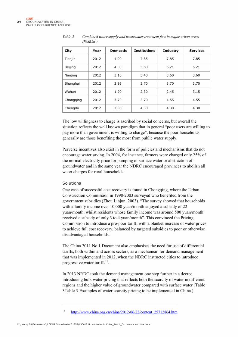
Table 2 Combined water supply and wastewater treatment fees in major urban areas
(RMB/m3)
City Year Domestic Institutions Industry Services
Tianjin 2012 4.90 7.85 7.85 7.85
Beijing 2012 4.00 5.80 6.21 6.21
Nanjing 2012 3.10 3.40 3.60 3.60
Shanghai 2012 2.93 3.70 3.70 3.70
Wuhan 2012 1.90 2.30 2.45 3.15
Chongqing 2012 3.70 3.70 4.55 4.55
Chengdu 2012 2.85 4.30 4.30 4.30
The low willingness to charge is ascribed by social concerns, but overall the
situation reflects the well known paradigm that in general “poor users are willing to
pay more than government is willing to charge”, because the poor households
generally are those benefiting the most from public water supply.
Perverse incentives also exist in the form of policies and mechanisms that do not
encourage water saving. In 2004, for instance, farmers were charged only 25% of
the normal electricity price for pumping of surface water or abstraction of
groundwater and in the same year the NDRC encouraged provinces to abolish all
water charges for rural households.
Solutions
One case of successful cost recovery is found in Chongqing, where the Urban
Construction Commission in 1998-2003 surveyed who benefited from the
government subsidies (Zhou Linjun, 2003). “The survey showed that households
with a family income over 10,000 yuan/month enjoyed a subsidy of 22
yuan/month, whilst residents whose family income was around 500 yuan/month
received a subsidy of only 3 to 4 yuan/month”. This convinced the Pricing
Commission to introduce a pro-poor tariff, with a blanket increase of water prices
to achieve full cost recovery, balanced by targeted subsidies to poor or otherwise
disadvantaged households.
The China 2011 No.1 Document also emphasises the need for use of differential
tariffs, both within and across sectors, as a mechanism for demand management
that was implemented in 2012, when the NDRC instructed cities to introduce
progressive water tariffs11
.
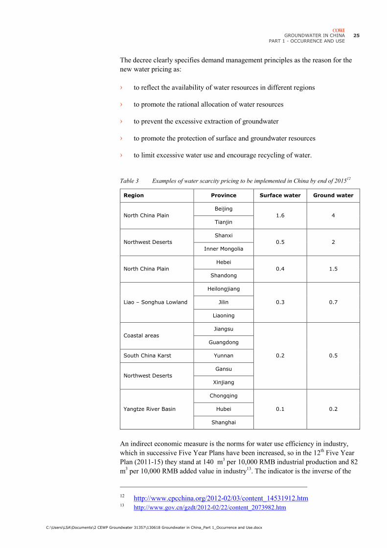
In 2013 NRDC took the demand management one step further in a decree
introducing bulk water pricing that reflects both the scarcity of water in different
regions and the higher value of groundwater compared with surface water (Table
3Table 3 Examples of water scarcity pricing to be implemented in China ).
11 http://www.china.org.cn/china/2012-06/22/content_25712864.htm
GROUNDWATER IN CHINA
PART 1 - OCCURRENCE AND USE
C:\Users\LSA\Documents\2 CEWP Groundwater 31357\130618 Groundwater in China_Part 1_Occurrence and Use.docx
25
The decree clearly specifies demand management principles as the reason for the
new water pricing as:
› to reflect the availability of water resources in different regions
› to promote the rational allocation of water resources
› to prevent the excessive extraction of groundwater
› to promote the protection of surface and groundwater resources
› to limit excessive water use and encourage recycling of water.
Table 3 Examples of water scarcity pricing to be implemented in China by end of 201512
Region Province Surface water Ground water
North China Plain
Beijing
1.6 4
Tianjin
Northwest Deserts
Shanxi
0.5 2
Inner Mongolia
North China Plain
Hebei
0.4 1.5
Shandong
Liao – Songhua Lowland
Heilongjiang
0.3 0.7 Jilin
Liaoning
Coastal areas
Jiangsu
0.2 0.5
Guangdong
South China Karst Yunnan
Northwest Deserts
Gansu
Xinjiang
Yangtze River Basin
Chongqing
0.1 0.2 Hubei
Shanghai
An indirect economic measure is the norms for water use efficiency in industry,
which in successive Five Year Plans have been increased, so in the 12th Five Year
Plan (2011-15) they stand at 140 m3 per 10,000 RMB industrial production and 82
m3 per 10,000 RMB added value in industry
13. The indicator is the inverse of the
12 http://www.cpcchina.org/2012-02/03/content_14531912.htm
13 http://www.gov.cn/gzdt/2012-02/22/content_2073982.htm
26 GROUNDWATER IN CHINA
PART 1 OCCURRENCE AND USE
C:\Users\LSA\Documents\2 CEWP Groundwater 31357\130618 Groundwater in China_Part 1_Occurrence and Use.docx
financial value of water and corresponds to a value of approximately 100 RMB/m3,
which indicates a substantial scope for raising water prices.
In summary potential solutions include:
› Awareness raising on the benefits of full-cost recovery of water services for
water demand management and sector finance
› Capacity building in financial and economic analysis of water and wastewater
services.

GROUNDWATER IN CHINA
PART 1 - OCCURRENCE AND USE
C:\Users\LSA\Documents\2 CEWP Groundwater 31357\130618 Groundwater in China_Part 1_Occurrence and Use.docx
27
4 Key policies, strategies and actions
China is rapidly modernising its water policies and strategies and is also making
significant progress in groundwater management.
Key policies, strategies and actions taken in recent years include:
› China 2011 No.1 Document
› Three Red Lines Strategy
› 2011-2020 Groundwater Pollution Prevention Plan
› 2004-2015 Water Action Plan
› New national monitoring programme
4.1 China 2011 No.1 Document
Each year the first decision of the Central Committee of the Communist Party of
China and the State Council spells out the government priorities for the year. In the
past this so-called No.1 Document has addressed the significance and living
conditions of the rural population, who has been the backbone of the state.
The 2011 No.1 Document on “Accelerating Water Conservancy Reform and
Development” broke this tradition by defining a 10 year program of policy reforms
in the water sector and pledging to raise 4,000 billion RMB for investment in
infrastructure, mainly for flood protection, improved irrigation infrastructure and
increased coverage of rural water supply and sanitation that all lie within the
mandate of the MWR. The No.1 Document lists a number of financing
mechanisms to be activated, some of which are beyond the control of the MWR,
hence the amount of 4,000 billion RMB should be seen as a target rather than a
firm budget. Noticeably the price of domestic water supply and sanitation is not
among these financing mechanisms, although it is clear that continued urban
development will require substantial finance to upgrade and extend urban water
and wastewater systems, the reason being that these sub-sectors are under the
mandate of MoHURD and MEP and not that of MWR.

28 GROUNDWATER IN CHINA
PART 1 OCCURRENCE AND USE
C:\Users\LSA\Documents\2 CEWP Groundwater 31357\130618 Groundwater in China_Part 1_Occurrence and Use.docx
The No.1 Document introduces Three Red Lines Strategy for better water
resources management, including specific reference to groundwater “The
underground water management and protection should be tightened up by checking
and announcing the scope of prohibited and restricted water drawing as soon as
possible and gradually reducing the excessive amount of underground water drawn
for the balance between drawing and supplying” (Article 19).
The document also opens for greater use of economic instruments, such as a
“system of progressive price for industrial and service water usage above the
quota”, “widening the water price difference between high water consumption
industries and other industries” and “reasonably adjust water price for urban
residential use by steadily implementing a system of differential water pricing”.
4.2 Three Red Lines Strategy
The 12th Five Year Plan (2011-2015) sets a cap on total water abstraction of 635
billion m3 by 2015 and 670 billion m
3 by 2020, hence “the most stringent water
management” will be required to maintain social-economic development. China
intends to do so by implementation of the “Three Red Lines Strategy” (State
Council, 2012):
› The first red line sets water quantity objectives in rivers, lakes and
groundwater. It requires the “total quantity control of water abstraction”
namely less than 635 billion m3 by 2015 and 670 billion m
3 by 2020
› The second red line sets objectives for water use efficiency. This will require
strict water demand management by strengthening of existing administrative
instruments such as stricter water use quotas in combination with differential
water pricing for high water consumption industries and the service industry.
› The third red line sets objectives for water quality by demands on reduction
of pollution loads to stay within the assimilation capacity of Water Functional
Zones (WFZ) of rivers and lakes.
The first red line on water quantity will be implemented by allocation of water
quotas to provinces, which subsequently must allocate water to sectors and
individual water users. The initial implementation plan for the water allocation is
attached as Appendix B. The China Europe Water Platform will assist MWR to
implement the Three Red Lines Strategy by joint development of integrated water
permit procedure gradually addressing each of the Three Red Lines.
The target of 635 billion m3 per year corresponds to an average of 500
m3/capita/year, which on the one hand compares with a world average of 2000
m3/capita/year indicating severe water scarcity in China, but on the other hand it
compares with a total consumption of 200 m3/capita/year in Denmark. The
principal difference lies in the large demands of irrigated agriculture in China and
will require research on water footprints of different crops for a more qualified
comparison.

GROUNDWATER IN CHINA
PART 1 - OCCURRENCE AND USE
C:\Users\LSA\Documents\2 CEWP Groundwater 31357\130618 Groundwater in China_Part 1_Occurrence and Use.docx
29
Regarding the second red line on water use efficiency, it is estimated that the
industry in China on average uses 30% – 40% more water per unit production than
similar industries in Europe.
Water losses in major cities in China are reported to be at or below 15% (Figure
14), which incidentally is the official government target and appears unlikely
considering the performance of water utilities in Europe (Figure 15). Only a few
large cities, such as Shanghai and Nanjing report higher water losses, noticeably up
to 40% that probably are more representative. Among the next level cities in China
the performance is also surprisingly high (Figure 16).
Figure 14 Water losses in the largest cities in China in 2009 (National Bureau of Statistics of
China, 2009)
Figure 15 Water losses from public distribution systems in Europe in 2007 (Source: EU
Commission)
Figure 16 Water losses in mega-cities in China in 2009 National Bureau of Statistics of
China, 2009

30 GROUNDWATER IN CHINA
PART 1 OCCURRENCE AND USE
C:\Users\LSA\Documents\2 CEWP Groundwater 31357\130618 Groundwater in China_Part 1_Occurrence and Use.docx
The third red line on water quality in receiving waters will be achieved by
allocation of pollution quotas within Water Functional Zones, which are river
reaches where water quality must meet a set water quality objective. This approach
is in sharp contrast with Europe, but should be seen as a relevant first step for
China to curb the severe surface water pollution. Definition of pollution quotas will
require substantial water quality modelling.
4.3 2004-2015 Water Action Programme
When responsibility for groundwater management was transferred to the MWR the
ministry launched the 2004-2015 Water Action Programme to build capacity in
groundwater management and protection, and to promote the regulation of
groundwater abstraction in overdraft areas.
The objectives of the Water Action Programme are:
› To promote groundwater legislation and build a better management system
› To investigate the existing implementation of groundwater abstraction permits
› To develop a groundwater information management system
› To assist the implementation of the South-to-North Water Transfer in areas
with excessive groundwater exploitation.
The plan for 2010 (MWR, 2010) states that that groundwater abstraction has
reached 150 billion m3, which is almost 50% higher than recorded in the official
statistics (MWR, 2011).
The 2010 work plan addresses both management and development of groundwater
in the following projects:
Groundwater management:
1 "Groundwater Management Handbook"
2 National Review over exploited groundwater
3 Supervision and management of groundwater exploitation
4 Total control of the national programming of groundwater exploitation
5 Technology exchange and training
6 Groundwater conservation science and advocacy
7 Preparation of national communications and information release of
groundwater

GROUNDWATER IN CHINA
PART 1 - OCCURRENCE AND USE
C:\Users\LSA\Documents\2 CEWP Groundwater 31357\130618 Groundwater in China_Part 1_Occurrence and Use.docx
31
Groundwater development and protection:
8 Baicheng “White” City (Jilin) Pilot groundwater protection actions (Liao-
Songhua)
9 Anshan City (Liaoning) - Groundwater protection in geothermal water mining
area (Liao-Songhua)
10 Cangzhou (Southeast Hebei) - Integrated Management of Surface and
Groundwater, protecting the South-to-North Water Diversion Project against
land subsidence and benefitting from it for groundwater recharge (North
China Plain)
11 Yantai City (Shandong) – Protection against seawater intrusion (Coastal areas)
12 Jinan City (Shandong) Protection of groundwater springs
13 Suzhou and Wuxi (Jiangsu) Impact of excessive groundwater abstraction on
groundwater levels and pressure
14 Jiaxing City (Zhejiang) Comprehensive management of groundwater for land
subsidence (Coastal areas)
15 Bijie region (Guizhou) - Groundwater protection in South China Karst area
(Investigated by DHI China)
16 Wuwei City (Gansu) - Groundwater protection in ecological fragile zone
(Shiyang River Basin in the Northwest Deserts, see Appendix A)
17 Taiyuan (Shanxi) - Groundwater protection in Northern China main coal
mining area (Loess Plateau).
The Groundwater Action Programme has contributed to further development of
groundwater protection, however, the 2010 Action Plan states that groundwater
protection remains an outstanding problem in China in the following aspects:
› Groundwater management and protection system remains imperfect
› Groundwater management and supervision still need to be strengthened
› Groundwater over abstraction and the resulting land subsidence, seawater
intrusion and ecological deterioration have yet to be effectively controlled.
These deficiencies affect the sustainable use of groundwater resources and threaten
the safety of drinking water, food security, ecological security and sustainable
economic and social development.

32 GROUNDWATER IN CHINA
PART 1 OCCURRENCE AND USE
C:\Users\LSA\Documents\2 CEWP Groundwater 31357\130618 Groundwater in China_Part 1_Occurrence and Use.docx
4.4 2011-2020 groundwater pollution prevention
plan
In 2011 State Council approved the “National Groundwater Pollution Prevention
Plan 2011-2020” jointly submitted by MEP, MLR and MWR14
. According to the
plan China will invest a total of 25 billion RMB in the prevention and treatment of
groundwater pollution during the period 2011-2020, of which 20 billion RMB will
be assigned to demonstration projects for protection of groundwater sources of
drinking water and 5 billion RMB for groundwater pollution prevention projects,
including agricultural non-point source pollution.
4.5 New national monitoring programme
Ministry of Land and Resources (MLR) began groundwater monitoring in the
1950s and has established a groundwater monitoring network at national,
provincial and city levels. Until now, MLR operates over 23,800 groundwater
monitoring points covering an area of 1.1 million km2, equal to 10% of the total
area of China (Figure 17).
MLR and MWR are planning to establish a new national groundwater monitoring
network with some 20,000 monitoring points, but the overlap with the existing
monitoring network is not known.
Figure 17 MLR National groundwater monitoring points
14 http://news.xinhuanet.com/english2010/china/2011-10/29/c_122211369.htm

GROUNDWATER IN CHINA
PART 1 - OCCURRENCE AND USE
C:\Users\LSA\Documents\2 CEWP Groundwater 31357\130618 Groundwater in China_Part 1_Occurrence and Use.docx
33
5 Conclusions
Groundwater is rapidly emerging as a major issue in water resources management
in China due to the increasingly evident impact on agricultural production and land
subsidence. The focus on groundwater in the Danish bilateral cooperation with
China promoted by the EU China River Basin Management Programme and the
Danish lead of the China Europe Water Platform has further raised awareness
within government.
During the past 50 years use of groundwater has supported socio-economic
development in northern China despite serious water shortages, but unsustainable
abstraction has placed the groundwater resource itself at risk, negatively impacted
groundwater quality and caused significant land subsidence in coastal areas with
increasing costs for repair of urban infrastructure.
Three hydro-geological regions have been identified as priority areas for measures
to improve groundwater management and protection:
› North China Plain comprising Beijing and surrounding areas of Hebei
Province
› Coastal areas, including Tianjin City, North-East Hebei, Shandong and
Jiangsu Provinces
› Northwest Deserts with the Hexi Corridor / Silk Road in Gansu Province as
type locality.
The Ministry of Water Resources has identified Shandong Province as the priority
area in Chinese perspective based on three , because the province represents three
› Restoration of depleted groundwater aquifers on the North China Plain
› Mitigation of seawater intrusion in coastal areas
› Protection of groundwater dependent eco-systems.
The market opportunities mainly lie within government to government exchange of
groundwater management practices in survey, resource assessment, spatial

34 GROUNDWATER IN CHINA
PART 1 OCCURRENCE AND USE
C:\Users\LSA\Documents\2 CEWP Groundwater 31357\130618 Groundwater in China_Part 1_Occurrence and Use.docx
planning, which in Danish perspective includes the following private sector know-
how, software and technologies:
› Modern groundwater survey technology, such as SkyTEM
› Modern hydro-geological modelling tools for groundwater resource
assessment and developing abstraction strategies
› Efficient and self-regulating submersible pumps reducing power consumption
and the risk of borehole damage due to excessive abstraction
› Groundwater treatment technologies, especially for brackish and polluted
groundwater
› Restoration of streams and wetlands.

GROUNDWATER IN CHINA
PART 1 - OCCURRENCE AND USE
C:\Users\LSA\Documents\2 CEWP Groundwater 31357\130618 Groundwater in China_Part 1_Occurrence and Use.docx
35
6 References
BWA, 2012. Groundwater Resource Sustainable Utilization Planning in Beijing.
Presentation by Liao Pingan, Director of International Relations, Beijing Water
Authority, at Groundwater Roundtable 29 March 2012, Royal Danish Embassy,
Beijing.
CGS, 2009. Investigation and Assessment of Sustainable Utilization of
Groundwater Resources in the North China Plain. China Geological Survey,
Geology Press, Beijing.
Evans, R.S., 2001. A groundwater management strategy for the North China Plain.
Presentation of “Agenda for Water Sector Strategy for North China” prepared by
Sinclair Knight, Merz and Egis Consulting for World Bank and Ministry of Water
Resources.
GIWP, 2012. Planning of Groundwater Protection in China. Presentation by
Engineer Yu Lili, General Institute of Water Resources and Hydropower Planning
and Design, at Groundwater Roundtable 29 March 2012, Royal Danish Embassy,
Beijing.
Klee, P. (Editor), 2013. Greater water security with groundwater – Groundwater
mapping and sustainable groundwater management. The Rethink Water network
and Danish Water Forum white papers, Copenhagen. Available at
www.rethinkwater.dk.
Li, J., 2010. Water shortages loom as northern China’s aquifers are sucked dry.
Science, Vol. 328, pp. 1462-1463.
Liu, Heng, 2012: Water Challenges and Opportunities in China. Seminar
presentation at China Europe International Business School on the occasion of EU
Day, 09 May 2012.
Liu, C.M. and Z.Y. Wei, 1989. Agricultural Hydrology and Water Resources of the
North China Plain. Science Press, Beijing (In Chinese)

36 GROUNDWATER IN CHINA
PART 1 OCCURRENCE AND USE
C:\Users\LSA\Documents\2 CEWP Groundwater 31357\130618 Groundwater in China_Part 1_Occurrence and Use.docx
Liu, J., C. Zheng, L. Zheng, and Y. Lei. 2008. Ground water sustainability:
methodology and application to the North China Plain. Ground Water 46, no. 6:
897–909.
MWR and MLR, 2010. Title not found. Ministry of Water Resources and Ministry
of Land and Resources, 2010.
MWR, 2010: Groundwater Conservation Action Project in 2010.
MWR, 2011. Annual Report on 2010.
Oelert, A. and D. Rosbjerg, 2005a. Characteristics of the Water Cycle and Climate
Development in the Arid Environments of the Shule River Basin. Symposium on
Sustainable Water Resource Management and Oasis-Hydrosphere-Desert
Interaction in Arid Regions, Beijing 27-29 October 2005.
Oelert, A. and D. Rosbjerg, 2005b. Hydrological modelling of the surface water in
the Shule river Basin. Symposium on Sustainable Water Resource Management
and Oasis-Hydrosphere-Desert Interaction in Arid Regions, Beijing 27-29 October
2005.
Oelert, A. and D. Rosbjerg, 2007. Water distribution and resource management in
the Shule River Basin. In Proceeding of the third International Symposium on
Integrated Water Resources Management: Reducing the Vulnerability of Societies
to Water Related Risks at Basin Scale in Bochum Germany 2006. IAHS
Publication 217, pp 191-196. (0-3% of rainfall)
Syvitski, J.P.M, Albert J. Kettner, Irina Overeem, Eric W. H. Hutton, Mark T.
Hannon, G. Robert Brakenridge, John Day, Charles Vörösmarty, Yoshiki Saito,
Liviu Giosan & Robert J. Nicholls, 2009. Sinking deltas due to human activities
Nature Geoscience 2, 681 – 686.
Wang, B., M. Jin, J. R. Nimmo, Yang, L. and Wang, W., 2008. Estimating
groundwater recharge in Hebei Plain, China under varying land use practices using
tritium and bromide tracers. Journal of Hydrology 356, 209-222
(http://wwwrcamnl.wr.usgs.gov/uzf/abs_pubs/papers/JH.356.pdf ).
Wang, Q, 2009. Three river delta areas sinking, report claims. China Daily, 23
September 2009.
Wang Ya, Jiu Jimmy Jiao, John A. Cherry, 2012. Occurrence and geochemical
behaviour of arsenic in a coastal aquifer–aquitard system of the Pearl River Delta,
China. Science of the Total Environment 427-428 (2012) 286–297.
Webber, M., J. Barnett, B. Finlayson and Wang, M., 2008. Pricing China’s
irrigation water. Global Environmental Change. Elsevier.
WRDMAP, 2010. Role of WUA in Water Savings in Groundwater. UK China
Water Resources Demand Management Assistance Project Advisory Note 6.1.1
(www.wrdmap.com).

GROUNDWATER IN CHINA
PART 1 - OCCURRENCE AND USE
C:\Users\LSA\Documents\2 CEWP Groundwater 31357\130618 Groundwater in China_Part 1_Occurrence and Use.docx
37
Xianjun Xie, Yanxin Wang, Andre Ellis, Chunli Su, Junxia Li, Mengdi Li and
Mengyu Duan, 2013. Delineation of groundwater flow paths using hydrochemical
and strontium isotope composition: A case study in high arsenic aquifer systems of
the Datong basin, northern China. Journal of Hydrology 476 (2013) 87–96.
Xin, D. and W. Xu, 2011. Experts warn of subsidence threat along new railway –
Extracting underground water poses danger to line’s stability. China Daily, 18 June
2011.
Xu, Y., X. Mo, Y. Cai and X. Li, 2005. Analysis on groundwater table drawdown
by land use and the quest for sustainable water use in the Hebei Plain in China.
Agricultural Water Management 75, 38-53. Elsevier.
http://www.sciencedirect.com/science/article/pii/S037837740400352X
Zhao, Hui, 2012. Why is groundwater important for China. Presentation at
Groundwater Roundtable at Royal Danish Embassy, Beijing, 25 September 2012.
Zheng, Chunmaio, Jie Liu, Guoliang Cao, Eloise Kendy, Hao Wang and Yangwen
Jia, 2010. Can China Cope with Its Water Crisis? – Perspectives from the North
China Plain. Groundwater 48 (3), pp. 350-354.


GROUNDWATER IN CHINA
PART 1 - OCCURRENCE AND USE
C:\Users\LSA\Documents\2 CEWP Groundwater 31357\130618 Groundwater in China_Part 1_Occurrence and Use.docx
39
Appendix A
Appendix A Regional characteristics
This Appendix reviews information on the current status of groundwater
abstraction and use in the 8 groundwater regions (MWR, 2011). The review
suggests that the existing data on groundwater resources and use is incomplete and
in some cases inconsistent.
A.1 Liao-Songhua lowland
Occurrence
The Liao-Songhua lowland comprises the river valleys of the Liao and Songhua
rivers and stretches from the Bohai Gulf to the Heilongjiang (Amur River), which
forms the boundary between China and Russia. Liao River flows south-west into
the Bohai Gulf, while Songhua River flows north-east to Heilongjiang.
Songhua is known for the 2005 Jilin accident15
, when an explosion in a petro-
chemical plant caused a spill of some 100 ton of benzene and nitrobenzene into the
Songhua River and over the following two weeks closed the urban water supply
along Songhua and Heilongjiang16
.
Groundwater aquifers occur over large areas in the relatively shallow alluvial
deposits of the river valleys.
Use
Groundwater constitutes approximately half of the water supply (Table 4) with
agriculture as the dominant use (Table 5), but equally significant is that
groundwater abstraction in the Liao-Songhua lowland constitutes almost 25% of
the total groundwater use in China.
15 http://en.wikipedia.org/wiki/2005_Jilin_chemical_plant_explosions
16 http://www.dhigroup.com/upload/publications/mike11/Skotner_A_Tailored_GIS.pdf -
http://www.dhigroup.com/News/2005/11/30/ChemicalSpillMovingThroughSonghuaR
iverTowardsRussia.aspx

40 GROUNDWATER IN CHINA
PART 1 OCCURRENCE AND USE
C:\Users\LSA\Documents\2 CEWP Groundwater 31357\130618 Groundwater in China_Part 1_Occurrence and Use.docx
Table 4 Water supply in the Liao-Songhua lowland (billion m3)
Province / City Surface Water Groundwater Total*
Liaoning 7.2 6.8 14.0
Jilin 7.6 4.4 12.0
Heilongjiang 17.9 14.6 32.5
Total 32.7 25.8 58.5
* Minor other sources omitted
Table 5 Main water uses in the Liao-Songhua lowland (billion m3)
Province / City Domestic Industry Agriculture Total*
Liaoning 2.5 2.5 9.0 14.0
Jilin 1.6 2.6 7.4 11.6
Heilongjiang 1.8 5.6 25.0 31.4
* Minor other uses omitted
Assuming that 70% of domestic and 50% of industrial water use comes from
groundwater sources, the sector distribution of groundwater use (Figure 18)
corresponds to the overall use of groundwater in China (Figure 6).
Figure 18 Estimated sector distribution of groundwater use in the Liao-Songhua lowlands
Key issues
Groundwater use in the Liao-Songhua lowland is not associated with major issues,
but the following should be of general concern:
› High dependence on groundwater during the extremely cold winters when
even major surface water source freeze
Domestic
Industry
Agriculture

GROUNDWATER IN CHINA
PART 1 - OCCURRENCE AND USE
C:\Users\LSA\Documents\2 CEWP Groundwater 31357\130618 Groundwater in China_Part 1_Occurrence and Use.docx
41
› Substantial use in urban water supply which requires high water security
› High use in agriculture with risk of unsustainable abstraction.
A.2 North China Plain
Groundwater occurrence
The North China Plain is built by overlapping flood plains of the Hai, Yellow and
Huai River. Today it is split in a northern part around the Hai River and a southern
part around the Huai River, separated by the elevated course of the Yellow River
(Figure 19), which for 800 km from Zhengzhou to the sea flows between dikes 10-
20 m above the old flood plain.
The flood plains started off as alluvial cones of gravel and sand deposited where
the Yellow River emerged from the Loess Plateau and Taihang Mountains of
central China, gradually building the 400 km wide flood plains to the present coast.
The first major attempts at harnessing the floods of the Yellow River took place
already 2000 BC, but sedimentation in the river bed led again and again to the river
breaching its dikes and shifting its course to the sea causing major floods.
Historically the Yellow River has seen 10 major shifts of its course since 70 AD, at
times flowing northeast across the current Hai River basin to the Bohai Sea north
the Shandong Peninsula and at times southeast across the present Huai River flood
plain to discharge south of the Shandong Peninsula or into the Yangtze River.
The flood plains consist of alternating layers of gravel, sand and clay. They are
dominated by gravel and sand in the foothills (Piedmont) of the mountains hosting
excellent aquifers, but gradually give way to thinner layers of sand deposited by
rivers meandering over the floodplains and finally to layers dominated by clay and
organic sediments deposited in estuaries and swamps along the coast (Figure 20).
Towards the coast past variations in sea level means that saline water may be
trapped in deep aquifers.
Figure 19 North China and
Huai River Flood
Plains
Figure 20 Schematic diagram of the North China Plain
(from Evans, 2001)
The hydro-geological zoning of the North China Plain is clearly reflected in the
scale and impact of groundwater abstractions.

42 GROUNDWATER IN CHINA
PART 1 OCCURRENCE AND USE
C:\Users\LSA\Documents\2 CEWP Groundwater 31357\130618 Groundwater in China_Part 1_Occurrence and Use.docx
In the mountain foothills in the west (Figure 21) the coarse deposits have enabled a
heavy abstraction, which has caused a steady drawdown of the water table of about
1 m/year since 1965 (Figure 22) and a corresponding increase in the areas of
drawdown cones, which by today affect almost the entire foothill zone (Figure 23).
Figure 21 Geological zoning of North China Plain in Hebei Province (Wang et al, 2008)
Across the alluvial plains, where aquifers are thinner and with lower yields, the
average drawdown has been in the range 0.3-0.5 m/year. To compensate for the
lower yields abstraction has turned to increasingly deep aquifers resulting in
extensive decline of the pressure levels across most of the central alluvial plain
(Figure 24Figure 23).
Areas with drawdowns of more than 200 mm are now estimated to cover 60,000
km2 or 40% of the area of the North China Plain. During the same period the
number of groundwater wells has increased from 2,000 to more than 700,000.

GROUNDWATER IN CHINA
PART 1 - OCCURRENCE AND USE
C:\Users\LSA\Documents\2 CEWP Groundwater 31357\130618 Groundwater in China_Part 1_Occurrence and Use.docx
43
Figure 22 Drawdown of shallow groundwater levels and increase of areas affected by
drawdown cones in the Shijiazhuang area (Zheng et al., 2010).
Figure 23 Areas of North China Plain with significant drawdown of water levels in shallow
aquifers and of pressure levels in deep aquifers (Zheng et al., 2010)
Groundwater recharge is low. Original recharge from rainfall is estimated at a
maximum of 30 mm, but up to 20% of the irrigation water is estimated to infiltrate
the top soil (Wang et al., 2008).
0
50
100
150
200
250
300
350
400
450
-50
-45
-40
-35
-30
-25
-20
-15
-10
-5
0
1960 1965 1970 1975 1980 1985 1990 1995 2000 2005 2010
Are
a o
f d
raw
do
wn
co
ne
Dra
wd
ow
n in
me
tre
s b
elo
w s
uu
rfa
ce
Drawdown Area

44 GROUNDWATER IN CHINA
PART 1 OCCURRENCE AND USE
C:\Users\LSA\Documents\2 CEWP Groundwater 31357\130618 Groundwater in China_Part 1_Occurrence and Use.docx
Figure 24 Decline of groundwater pressure in deep aquifer at Cangzhou – W-E Section (Zhao,
2012)
Use
Groundwater constitutes approximately 75% of the water supply (Table 6), again
with agriculture as the dominant use (Table 7), but equally significant is that
groundwater use on the North China Plain constitutes almost 25% of the total
groundwater abstraction in China.
Table 6 Water supply to main areas of the North China Plain (billion m3)
Province / City Surface Water Groundwater Total*
Beijing 0.7 2.1 2.8
Tianjin 1.6 0.6 2.2
Hebei 3.6 15.6 19.2
Total 5.9 18.3 24.2
* Minor other sources omitted
Table 7 Main water uses on the North China Plain (billion m3)
Province / City Domestic Industry Agriculture Total*
Beijing 1.5 0.5 1.1 3.1
Tianjin 0.55 0.50 1.1 2.15
Hebei 2.4 2.3 14.4 19.1
Total 4.45 3.3 16.6 24.35
* Minor other uses omitted

GROUNDWATER IN CHINA
PART 1 - OCCURRENCE AND USE
C:\Users\LSA\Documents\2 CEWP Groundwater 31357\130618 Groundwater in China_Part 1_Occurrence and Use.docx
45
Assuming that 50% of domestic and industrial water use in Beijing and Tianjin
comes from groundwater sources, the sector distribution of groundwater use
(Figure 25) illustrates the substantial use of groundwater for agriculture on the
North China Plain.
Figure 25 Estimated sector distribution of groundwater use on the North China Plain
Key issues
Key issues in groundwater abstraction and use on the North China Plain are:
› Unsustainable abstraction from shallow and deep groundwater aquifers
› Upwelling of saline water in stratified aquifers with freshwater overlying
saline or brackish water.
Key issues or impacts arising from the unsustainable abstraction include:
› Deterioration, drying out and potential collapse of aquifers
› Deteriorating water quality
› Reduction of agricultural production
› Large scale land subsidence
The unsustainable abstraction is clearly evidenced by the long-term, huge and
steady decline of groundwater levels and pressures affecting increasingly large
areas of the North China Plain (Figure 23). Reliable groundwater resource
assessments do not appear to be available, thus it is difficult to assess how long
time the present level of abstraction can continue before the aquifers are exhausted
or the extent to which they already have collapsed. The recharge from rainfall is
low, while the recharge from irrigation is higher, but on average probably less than
50 mm per year corresponding to a recovery of the shallow groundwater table in
the order of 0.25 m per year.
Domestic
Industry
Agriculture
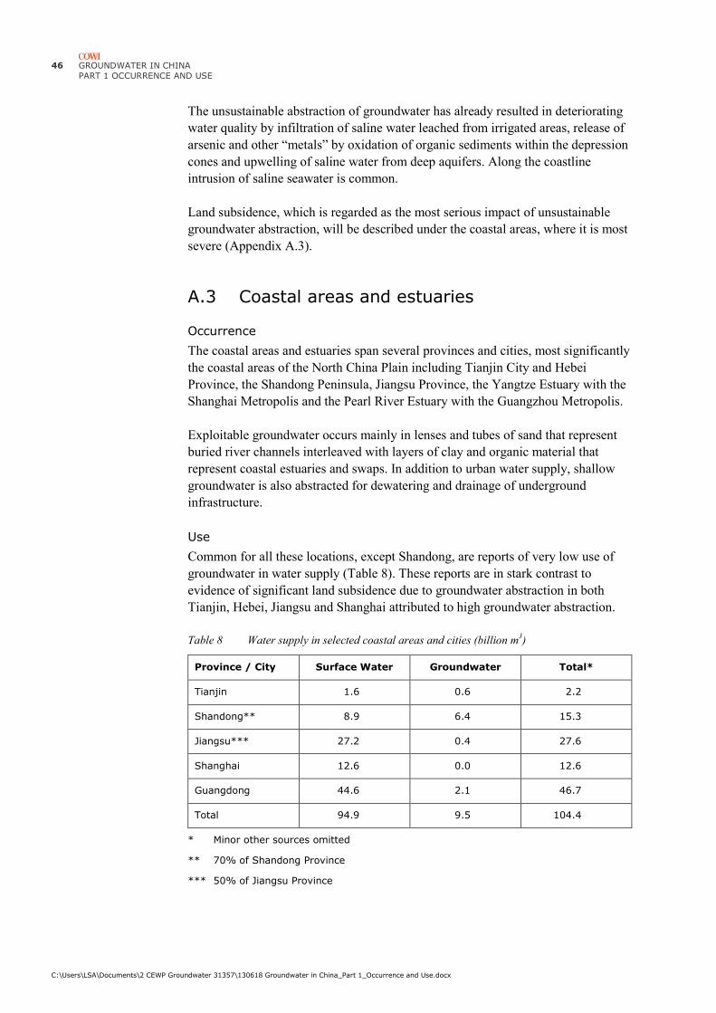
46 GROUNDWATER IN CHINA
PART 1 OCCURRENCE AND USE
C:\Users\LSA\Documents\2 CEWP Groundwater 31357\130618 Groundwater in China_Part 1_Occurrence and Use.docx
The unsustainable abstraction of groundwater has already resulted in deteriorating
water quality by infiltration of saline water leached from irrigated areas, release of
arsenic and other “metals” by oxidation of organic sediments within the depression
cones and upwelling of saline water from deep aquifers. Along the coastline
intrusion of saline seawater is common.
Land subsidence, which is regarded as the most serious impact of unsustainable
groundwater abstraction, will be described under the coastal areas, where it is most
severe (Appendix A.3).
A.3 Coastal areas and estuaries
Occurrence
The coastal areas and estuaries span several provinces and cities, most significantly
the coastal areas of the North China Plain including Tianjin City and Hebei
Province, the Shandong Peninsula, Jiangsu Province, the Yangtze Estuary with the
Shanghai Metropolis and the Pearl River Estuary with the Guangzhou Metropolis.
Exploitable groundwater occurs mainly in lenses and tubes of sand that represent
buried river channels interleaved with layers of clay and organic material that
represent coastal estuaries and swaps. In addition to urban water supply, shallow
groundwater is also abstracted for dewatering and drainage of underground
infrastructure.
Use
Common for all these locations, except Shandong, are reports of very low use of
groundwater in water supply (Table 8). These reports are in stark contrast to
evidence of significant land subsidence due to groundwater abstraction in both
Tianjin, Hebei, Jiangsu and Shanghai attributed to high groundwater abstraction.
Table 8 Water supply in selected coastal areas and cities (billion m3)
Province / City Surface Water Groundwater Total*
Tianjin 1.6 0.6 2.2
Shandong** 8.9 6.4 15.3
Jiangsu*** 27.2 0.4 27.6
Shanghai 12.6 0.0 12.6
Guangdong 44.6 2.1 46.7
Total 94.9 9.5 104.4
* Minor other sources omitted
** 70% of Shandong Province
*** 50% of Jiangsu Province

GROUNDWATER IN CHINA
PART 1 - OCCURRENCE AND USE
C:\Users\LSA\Documents\2 CEWP Groundwater 31357\130618 Groundwater in China_Part 1_Occurrence and Use.docx
47
Key issues
Key issues related to groundwater abstraction and use in the coastal areas are:
› Salinity intrusion
› Land subsidence
Salinity intrusion has been studied in detail at Yantai on the northern side of the
Shandong Peninsula (Rethink Water & Danish Water Forum, 2013) (Figure 11).
Here unsustainable pumping of groundwater has led to severe problems in relation
to both water quantity and water quality of the urban water supply. Progressive
intrusion of seawater into the aquifer has been observed during recent decades with
elevated salinity concentrations now extending more than 10 km from the
coastline. Attempts to artificially increase the groundwater recharge by surface
water reservoirs have not effectively pushed back the interface between fresh and
saline water. Analyses by integrated surface water and groundwater models of
recharge estimates, groundwater surface water exchange and density dependent
groundwater flow showed that compared to doing nothing the salinity intrusion
could be counteracted by changing recharge and pumping within 25 % of the
current levels and thereby avoiding high salinity concentrations the urban well
fields.
Land subsidence is regarded as the most serious impact of high groundwater
abstraction. It occurs wherever there is a heavy drawdown of the groundwater level
reducing the buoyancy provided by groundwater. It accelerates on flood plains,
coastal plains, deltas and estuaries, where layers of clay may collapse when drained
and organic material in the soil decomposes on exposure to atmospheric air.
On the North China Plain the geological structure results in an inverse relationship
between groundwater drawdown and land subsidence. In the western part
groundwater drawdowns are large, but the geology is dominated by gravel and
sand, which are less susceptible to collapse and subsidence than the layers of clay
and organic materials along the coast. The area with land subsidence greater than
100 mm has reached some 35,000 km2 within Hebei Province alone (Figure 26).

48 GROUNDWATER IN CHINA
PART 1 OCCURRENCE AND USE
C:\Users\LSA\Documents\2 CEWP Groundwater 31357\130618 Groundwater in China_Part 1_Occurrence and Use.docx
Figure 26 Land subsidence on the north China Plain by 2003
The rate of subsidence attributed to groundwater, should be seen in relation to
estimated sea level rise of 0.50 – 1.0 m by 2050. The relationship has been
examined within Yellow, Yangtze and Pearl River Deltas (Syvitski et al., 2009).
The results indicate that delta regions on average sink 4 times more rapidly than
can be explained by sea level rise alone.
The increased rate of subsidence in the deltas is attributed to a combination of:
› Increased sediment compaction due to abstraction of groundwater and mining
of oil and gas
› Increased compaction due to the weight of high-rise buildings, noticeably in
Shanghai
› Reduced sediment delivery flood protection infrastructure that inhibits
delivery of sediments to the delta or estuary flood plains
The areas particularly affected lie around Tianjin and Cangzhou with subsidence
up to 3 m (Figure 23, Figure 26). In and around Beijing some 3,000 km2 are
reported to have subsided more than 5 cm and in urban Shanghai an average of
7.5cm was reported for 2007 alone.
Scaled up the subsidence in Shanghai corresponds to 3.5 m for the period 2000-
2050 and although the rate of subsidence will reduce over time, it is likely to
remain more significant than sea level rise due to global warming that is estimated
in the range 0.50-2.0 m over the same period.
The repair of underground infrastructure due to land subsidence in urban areas is
estimated at 2 billion RMB per mm, matching reports that Shanghai has spent
more than 300 billion RMB during the past 50 years (Wang, 2009).

GROUNDWATER IN CHINA
PART 1 - OCCURRENCE AND USE
C:\Users\LSA\Documents\2 CEWP Groundwater 31357\130618 Groundwater in China_Part 1_Occurrence and Use.docx
49
A.4 Huai River Floodplain
Occurrence
The Huai River Floodplain has the same structure as the North China Plain and is
also a major agricultural area. In the northern part it shares key groundwater issues
with the North China Plan, but along the coast it benefits from higher rainfall.
Use
Groundwater constitutes approximately 60% of the water supply in Henan in the
northern inland part of the floodplain, but falls drastically moving towards the
coast in Shandong Province and moving south through Anhui and Jiangsu towards
the Yangtze River Basin, so overall it constitutes only 25% of the water supply
(Table 9) and around 15% of the total groundwater use in China.
Table 9 Water supply to main areas of the Huai River Floodplain (billion m3)
Province / City Surface Water Groundwater Total*
Henan 8.9 13.5 22.4
South Shandong** 4.2 2.7 6.9
North Anhui*** 13.3 1.3 14.6
North Jiangsu*** 27.2 0.4 27.6
Total 53.6 17.9 71.5
* Minor other sources omitted
** 30% of Shandong Province
*** 50% of Anhui and Jiangsu Provinces (Southern halves are in the Yangtze River Basin)
Key issues
Key issues in groundwater abstraction on the Huai River Floodplain combines the
North China Plan and the coastal areas:
› Unsustainable abstraction from shallow and deep groundwater aquifers,
especially in the northern part
› Salinity intrusion along the coast
› Land subsidence
Land subsidence due to groundwater abstraction is a concern for the Beijing-
Shanghai high-speed railway, which crosses the Huai River Floodplain (Xin and
Xu, 2011) causing the Ministry of Railways and provinces along the route (Hebei,
Shandong, Anhui, Jiangsu) to ban groundwater abstraction, initially in a 1 km wide
corridor along the railway.
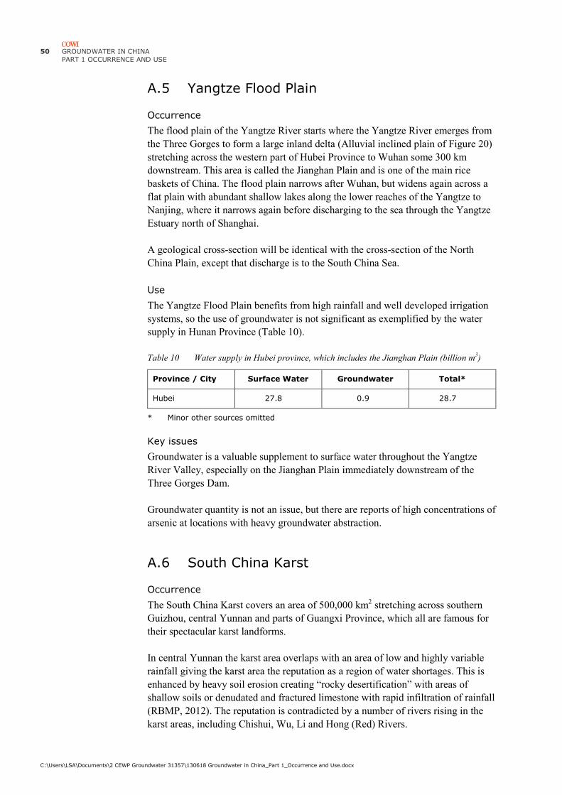
50 GROUNDWATER IN CHINA
PART 1 OCCURRENCE AND USE
C:\Users\LSA\Documents\2 CEWP Groundwater 31357\130618 Groundwater in China_Part 1_Occurrence and Use.docx
A.5 Yangtze Flood Plain
Occurrence
The flood plain of the Yangtze River starts where the Yangtze River emerges from
the Three Gorges to form a large inland delta (Alluvial inclined plain of Figure 20)
stretching across the western part of Hubei Province to Wuhan some 300 km
downstream. This area is called the Jianghan Plain and is one of the main rice
baskets of China. The flood plain narrows after Wuhan, but widens again across a
flat plain with abundant shallow lakes along the lower reaches of the Yangtze to
Nanjing, where it narrows again before discharging to the sea through the Yangtze
Estuary north of Shanghai.
A geological cross-section will be identical with the cross-section of the North
China Plain, except that discharge is to the South China Sea.
Use
The Yangtze Flood Plain benefits from high rainfall and well developed irrigation
systems, so the use of groundwater is not significant as exemplified by the water
supply in Hunan Province (Table 10).
Table 10 Water supply in Hubei province, which includes the Jianghan Plain (billion m3)
Province / City Surface Water Groundwater Total*
Hubei 27.8 0.9 28.7
* Minor other sources omitted
Key issues
Groundwater is a valuable supplement to surface water throughout the Yangtze
River Valley, especially on the Jianghan Plain immediately downstream of the
Three Gorges Dam.
Groundwater quantity is not an issue, but there are reports of high concentrations of
arsenic at locations with heavy groundwater abstraction.
A.6 South China Karst
Occurrence
The South China Karst covers an area of 500,000 km2 stretching across southern
Guizhou, central Yunnan and parts of Guangxi Province, which all are famous for
their spectacular karst landforms.
In central Yunnan the karst area overlaps with an area of low and highly variable
rainfall giving the karst area the reputation as a region of water shortages. This is
enhanced by heavy soil erosion creating “rocky desertification” with areas of
shallow soils or denudated and fractured limestone with rapid infiltration of rainfall
(RBMP, 2012). The reputation is contradicted by a number of rivers rising in the
karst areas, including Chishui, Wu, Li and Hong (Red) Rivers.
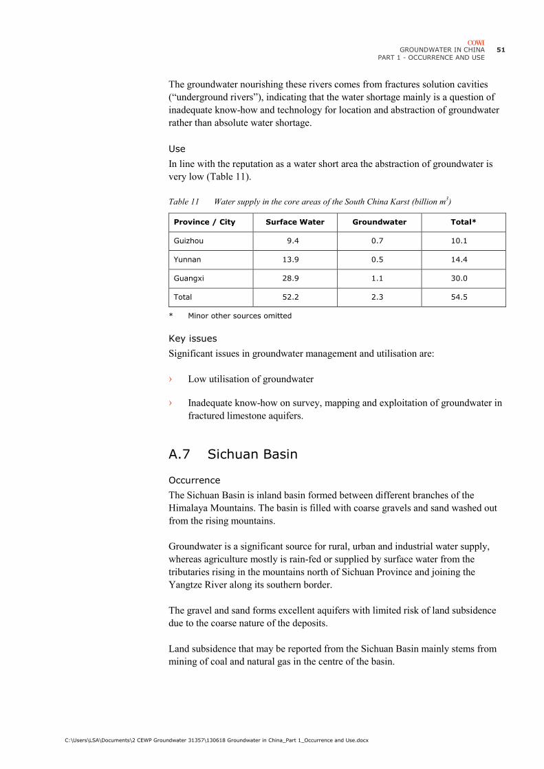
GROUNDWATER IN CHINA
PART 1 - OCCURRENCE AND USE
C:\Users\LSA\Documents\2 CEWP Groundwater 31357\130618 Groundwater in China_Part 1_Occurrence and Use.docx
51
The groundwater nourishing these rivers comes from fractures solution cavities
(“underground rivers”), indicating that the water shortage mainly is a question of
inadequate know-how and technology for location and abstraction of groundwater
rather than absolute water shortage.
Use
In line with the reputation as a water short area the abstraction of groundwater is
very low (Table 11).
Table 11 Water supply in the core areas of the South China Karst (billion m3)
Province / City Surface Water Groundwater Total*
Guizhou 9.4 0.7 10.1
Yunnan 13.9 0.5 14.4
Guangxi 28.9 1.1 30.0
Total 52.2 2.3 54.5
* Minor other sources omitted
Key issues
Significant issues in groundwater management and utilisation are:
› Low utilisation of groundwater
› Inadequate know-how on survey, mapping and exploitation of groundwater in
fractured limestone aquifers.
A.7 Sichuan Basin
Occurrence
The Sichuan Basin is inland basin formed between different branches of the
Himalaya Mountains. The basin is filled with coarse gravels and sand washed out
from the rising mountains.
Groundwater is a significant source for rural, urban and industrial water supply,
whereas agriculture mostly is rain-fed or supplied by surface water from the
tributaries rising in the mountains north of Sichuan Province and joining the
Yangtze River along its southern border.
The gravel and sand forms excellent aquifers with limited risk of land subsidence
due to the coarse nature of the deposits.
Land subsidence that may be reported from the Sichuan Basin mainly stems from
mining of coal and natural gas in the centre of the basin.

52 GROUNDWATER IN CHINA
PART 1 OCCURRENCE AND USE
C:\Users\LSA\Documents\2 CEWP Groundwater 31357\130618 Groundwater in China_Part 1_Occurrence and Use.docx
Use
The main groundwater abstraction takes place where the Min River emerges from
the mountains at Dujiangyan north of Chengdu and builds a large inland delta
stretching some 100 km to and beyond Chengdu. Coarse gravels and high recharge
from rainfall, rivers and irrigated areas makes groundwater an important source for
urban and industrial water supply and back-up for irrigation, though the
groundwater abstraction remains relatively low (Table 12).
Table 12 Water supply in Sichuan province (billion m3)
Province / City Surface Water Groundwater Total*
Sichuan 21.1 1.7 22.8
* Minor other sources omitted
Key issues
Significant issues in groundwater use:
› Groundwater pollution from industry in and around Chengdu and other major
cities
› Groundwater pollution from coal mining, oil and natural gas exploitation in
the centre of the basin.
A.8 Northwest Deserts
Occurrence
The north-western deserts are vast inland depressions filled with layers of gravel
and sand washed out from the rising Himalaya Mountains. In the west the
Taklamakan Desert covers most of Xinjiang Province (Figure 27), while in the east
the Gobi Desert covers most of Gansu and Inner Mongolia provinces and stretches
into Mongolia (Figure 28).
Figure 27 Taklamakan Desert in the Tarim
Basin
Figure 28 Gobi Desert covering northern
China and southern Mongolia

GROUNDWATER IN CHINA
PART 1 - OCCURRENCE AND USE
C:\Users\LSA\Documents\2 CEWP Groundwater 31357\130618 Groundwater in China_Part 1_Occurrence and Use.docx
53
A geological cross-section from the rim to the centre of these depressions would
look very much like the section across the North China Flood Plain, except that the
rivers terminate in inland oases, marshes or lakes such as Lop Nur (Figure 27) or
Minqin (Figure 29).
Shallow groundwater aquifers are recharged by rainfall or snow-melt in the
surrounding mountains while deep groundwater aquifers mainly contain fossil
water that no longer is recharged from the surface.
Groundwater forms in the foothills of the mountains, where the gravel may be so
coarse that rivers emerging from the mountains dry out due to rapid infiltration to
the groundwater (Figure 29). The groundwater emerges again as springs in the
foothills giving rise to inland rivers such as the Shiyang River (Figure 29).
Groundwater may also emerge in depressions further away from the mountains to
form the oases that constituted the stepping stones of the Silk Road, which in China
is known as the He Xi corridor (literally Western Rivers).
Figure 29 Shiyang River Basin in Gansu (Notice the mountain rivers drying out as they flow
across the alluvial fans forming the foothills of the Qilian Mountains,to emerge
again as springs, which form the Shiyang River)
Use
Groundwater is a major water source across the Northwest Deserts, where it
constitutes 25% of the total water supply and almost the same percentage of the
total groundwater use in China (Table 13).
Shiyang River
Hongyashan Reservoir

54 GROUNDWATER IN CHINA
PART 1 OCCURRENCE AND USE
C:\Users\LSA\Documents\2 CEWP Groundwater 31357\130618 Groundwater in China_Part 1_Occurrence and Use.docx
Table 13 Water supply in the Northwest Deserts (billion m3)
Province / City Surface Water Groundwater Total*
Inner Mongolia 9.3 8.9 18.2
Shaanxi 5.0 3.3 8.3
Gansu 9.6 2.4 11.0
Xinjiang 44.0 9.5 53.5
Total 67.9 24.1 91.0
* Minor other sources omitted
The vast majority of groundwater (70%) is used in agriculture (Table 14 and Figure
30), mainly for watering of livestock and cultivation of wheat, cotton and melons.
Wheat is used for production of noodles and Gansu noodles is one of the signature
dishes of the area that is famous across China.
Table 14 Main water uses on the North China Plain (billion m3)
Province / City Domestic Industry Agriculture Total*
Inner Mongolia 0.9 1.4 6.6 8.9
Shaanxi 0.9 0.7 1.7 3.3
Gansu 0.7 0.8 0.9 2.4
Xinjiang 0.8 0.7 8.1 9.5
Total 3.3 3.6 17.3 24.1
* Minor other uses omitted
Figure 30 Estimated sector distribution of groundwater use in the Northwest Deserts
Domestic
Industry
Agriculture
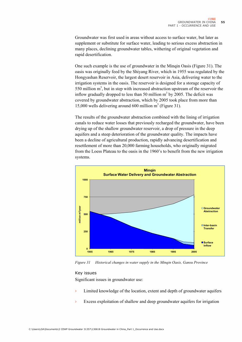
GROUNDWATER IN CHINA
PART 1 - OCCURRENCE AND USE
C:\Users\LSA\Documents\2 CEWP Groundwater 31357\130618 Groundwater in China_Part 1_Occurrence and Use.docx
55
Groundwater was first used in areas without access to surface water, but later as
supplement or substitute for surface water, leading to serious excess abstraction in
many places, declining groundwater tables, withering of original vegetation and
rapid desertification.
One such example is the use of groundwater in the Minqin Oasis (Figure 31). The
oasis was originally feed by the Shiyang River, which in 1955 was regulated by the
Hongyashan Reservoir, the largest desert reservoir in Asia, delivering water to the
irrigation systems in the oasis. The reservoir is designed for a storage capacity of
550 million m3, but in step with increased abstraction upstream of the reservoir the
inflow gradually dropped to less than 50 million m3 by 2005. The deficit was
covered by groundwater abstraction, which by 2005 took place from more than
15,000 wells delivering around 600 million m3 (Figure 31).
The results of the groundwater abstraction combined with the lining of irrigation
canals to reduce water losses that previously recharged the groundwater, have been
drying up of the shallow groundwater reservoir, a drop of pressure in the deep
aquifers and a steep deterioration of the groundwater quality. The impacts have
been a decline of agricultural production, rapidly advancing desertification and
resettlement of more than 20,000 farming households, who originally migrated
from the Loess Plateau to the oasis in the 1960’s to benefit from the new irrigation
systems.
Figure 31 Historical changes in water supply in the Minqin Oasis, Gansu Province
Key issues
Significant issues in groundwater use:
› Limited knowledge of the location, extent and depth of groundwater aquifers
› Excess exploitation of shallow and deep groundwater aquifers for irrigation
0
250
500
750
1000
1955 1965 1975 1985 1995 2005
mil
lio
n m
3/y
ea
r
MinqinSurface Water Delivery and Groundwater Abstraction
Groundwater
Abstraction
Inter-basin
Transfer
Surface
Inflow

56 GROUNDWATER IN CHINA
PART 1 OCCURRENCE AND USE
C:\Users\LSA\Documents\2 CEWP Groundwater 31357\130618 Groundwater in China_Part 1_Occurrence and Use.docx
› Dewatering of mines leading to local depletion and pollution of the
groundwater
› High salinity of (deep) groundwater
› High alkalinity causing release of arsenic from sediments
› Groundwater pollution from dewatering of mines
› Surface water infrastructure reducing groundwater recharge due to lining of
canals and high evaporation.
GROUNDWATER IN CHINA
PART 1 - OCCURRENCE AND USE
C:\Users\LSA\Documents\2 CEWP Groundwater 31357\130618 Groundwater in China_Part 1_Occurrence and Use.docx
57
Appendix B
Appendix B Schedule for water allocation

GROUNDWATER IN CHINA
PART 1 - OCCURRENCE AND USE
C:\Users\LSA\Documents\2 CEWP Groundwater 31357\130618 Groundwater in China_Part 1_Occurrence and Use.docx
58
Table 15 Preliminary list of rivers and river basins planned for gross water allocation control (2010-2012)
Number River Basin
Commission
River Basin 1st order rivers 2nd order rivers 3rd and lower
order rivers
Provinces and Autonomous Regions River Basin Area
((((km2))))
1 Songliao River
Water
Resources
Commission
Songhua River Nen River Inner Mongolia、Heilongjiang、Jilin 298,500
2 Songhua River Lalin River Heilongjiang、Jilin 19,923
3 Songhua River Second Songhua
River
Jilin、Liaoning 73,416
4 Liao River Dongliao River Jilin、Liaoning、Inner Mongolia 10,364
5 Hai River
Water
Resources
Commission
Hai River Jiyun River Beijing、Tianjin、Hebei 10,288
6 Hai River Daqing River Juma river Beijing、Hebei 10,154
7 Hai River Zhangwei River Zhang River Zhuozhang River Shanxi、Henan、Hebei 11,206
8 Yellow River
Conservancy
Commission
Yellow River Huangshui Datong River Qinghai、Gansu 15,130
9 Yellow River Wuding river Inner Mongolia、Shaanxi 30,261
10 Yellow River Wei River Gansu、Ningxia、Shaanxi 62,500
11 Yellow River Wei River Jing River Gansu、Ningxia、Shaanxi 45,400
12 Huai River
Water
Resources
Commission
Huai River Huai River Henan、Anhui、Jiangsu 187,000
13 Huai River Yishusi Yi River Shandong、Jiangsu 11,392
14 Huai River Yishusi Shu River Shandong、Jiangsu 5,970
15 Taihu Basin
Authority
Taihu Lake Jiangsu、Zhejiang、Shanghai、Anhui 36,895
16 Changjiang
Water
Resources
Commission
Changjiang River Han River Henan、Hubei、Chongqing、Sichuan、
Shaanxi、Gansu
154,804
17 Changjiang River Jialing River Sichuan、Chongqing、Gansu、Shanxi 159,357
18 Changjiang River Tuo River Sichuan、Chongqing 27,631
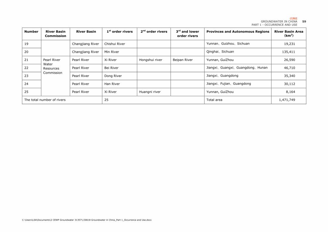
GROUNDWATER IN CHINA
PART 1 - OCCURRENCE AND USE
C:\Users\LSA\Documents\2 CEWP Groundwater 31357\130618 Groundwater in China_Part 1_Occurrence and Use.docx
59
Number River Basin
Commission
River Basin 1st order rivers 2nd order rivers 3rd and lower
order rivers
Provinces and Autonomous Regions River Basin Area
((((km2))))
19 Changjiang River Chishui River Yunnan、Guizhou、Sichuan 19,231
20 Changjiang River Min River Qinghai、Sichuan 135,411
21 Pearl River
Water
Resources
Commission
Pearl River Xi River Hongshui river Beipan River Yunnan, GuiZhou 26,590
22 Pearl River Bei River Jiangxi、Guangxi、Guangdong、Hunan 46,710
23 Pearl River Dong River Jiangxi、Guangdong 35,340
24 Pearl River Han River Jiangxi、Fujian、Guangdong 30,112
25 Pearl River Xi River Huangni river Yunnan, GuiZhou 8,164
The total number of rivers 25 Total area 1,471,749
