greening capitol way - olympia, waolympiawa.gov/.../greening-capitol-presentation1.pdfcharrette...
TRANSCRIPT

Greening Capitol Way
September 29, 2014
Public Meeting #1 Introduction to Project and Initial Concepts

2014 Capitals:
Olympia, WA
Montpelier, VT
Madison, WI
Lansing, MI

Study Area
•treatment and designing more engaging streetscape can:
– Establish stronger sense of place and connection between the Capitol Campus and downtown;
– Slow down and clean stormwater runoff that currently drains directly to Budd Inlet;
– Provide visual imagery to attract new businesses and visitors to downtown;
– Improve access and safety for bus riders, bicyclists, walkers, and drivers; and,
– Connect to and catalyze other exciting projects happening downtown.
Why Study Capitol Way?

Charrette
Greening Capitol Way
• Various session and focus group meetings for next two days: – Review initial street design concepts – Revise concepts based on city and
stakeholder input – Issue areas:
– Economic development, vitality and placemaking
–Multimodal transportation, circulation, walkability
– Green infrastructure, landscape, and climate resiliency
– Implementation – Closing Open House Presentation

Capitol Way
• Potential to be a vibrant main street linking the Capitol Campus through downtown to the Farmers Market

Existing & Proposed
Transit, Bike & Pedestrian Networks
• Policy framework for further improvements for pedestrians and bicycles in the downtown
• Supported by Washington Complete Streets policy
• Recent Improvements
– Capitol Way streetscape and bike lanes between State Avenue and Market Street

Existing
Transportation & Land Use Policy
• Urban and Strategy Corridors
• Zoning
• Parking
• Parks and open spaces
• Major employers
• Existing retail, restaurants, and services

Existing Supply
Public Parking
• Important asset for commercial uses
• Could be better signed and effectively used
• Improvements to pedestrian environment could support better functioning of
-district resource

Potential Network Concept
Transportation
• Utilize the full network to allow for a balancing of modes across full network
• Some streets have a modal emphasis
• Redesign of streets creates new landscape opportunities

Complete and Green Streets
• Combining two concepts for street design:
– Complete Streets + Green Streets
• Create streets:
– For all users – Reduce carbon footprint – Promote improved public health – Support economic vitality – Placemaking – Green infrastructure
• Manage and improve stormwater quality • Reduce water demand • Complement urban habitats
Source: outdoorchattanooga.com

Complete and Green Streets
• Balancing Travel Needs and Purposes
– Mobility
– Access
For All Users
Source: Sfgate.com Source: annarbor.com

Complete and Green Streets
• Balancing Travel Needs and Purposes
– Mobility
– Access
– Safety
For All Users
Source: http://www.walkinginfo.org
Source: http://mywheelsareturning.com

Complete and Green Streets
• Balancing Travel Needs and Purposes
– Mobility
– Access
– Safety
– Enjoyment
For All Users
Source: City of San Leandro Source: City of San Leandro
Source: joyandphil.blogspot.com

Complete and Green Streets
• health benefits of walking and biking An adult needs 150 min. of moderate activity per week to experience health benefits of physical activity
USHHS, 2008
• Less than 10% of Americans achieve this level of activity
Public Health
Source: blog.al.com

Complete and Green Streets
• Street trees and walkable environments can positively impact retail sales & rents
– 3-15% increase in home values
– Polling of shoppers indicates
• 9-12% more spending
• Spend more time in treed district
– Improved productivity of workers with views and access to trees/vegetation
Support Economic Vitality
Source: joyandphil.blogspot.com
Source: www.ca-ilg.org.com
• Street trees and walkable environments can positively impact retail sales & rents
– 3-15% increase in home values
– Polling of shoppers indicates
• 9-12% more spending1
• Spend more time in treed district
– Improved productivity of workers with views and access to trees/vegetation
1. Public Response to the Urban Forest in Inner-City Business Districts by Kathleen L. Wolf, Journal of Arboriculture 29(3), May 2003

Complete and Green Streets
• Design to complement and enhance surroundings
• Support unique identity
• Mark gateways or special places
Placemaking
Source: casscountyonline.com
Source: my.autinenergy.com

Complete and Green Streets
• Improved multi-modal circulation
• Helped increase business trade over
6% and fostered 40 new
development projects in 4 years
• Supported other community
building activities and brought
University and community
together
Placemaking example: University Way, Seattle
Source: annarbor.com

Complete and Green Streets
• Road diet
• Crime reduction
• Initiated a new downtown neighborhood
Placemaking example: Second Ave, Seattle
After
Before
New mixed use development

Complete and Green Streets
• Links and integrates parks and open spaces
•
• Creates an identity
Placemaking example: E St, Anchorage
Source: Sfgate.com Source: annarbor.com
Source: annarbor.com

Topography and Storm Drainage
Stormwater Infrastructure
• Terminus of Capitol Way is the low-point of the surrounding watershed
• Considerable amounts of runoff entering Capitol Way

Topography and Storm Drainage
Climate Resiliency
• Capture, infiltrate or redirect stormwater runoff prior to entering water bodies
• Much of Downtown is in low lying areas and subject to flooding, storm surges, and tidal influences
Source: Coast & Harbor Engineering, City of Olympia Engineered Response to Sea Level Rise

Impervious Area & Street Trees
Existing Conditions
• Many existing mature street trees in downtown. Sidewalks are buckling due to surface roots
• Inconsistent placement of street trees (building awnings, back of sidewalk
• Very little ground plane landscaping along Capitol Way

Green Infrastructure Toolbox
• Street Trees & Conventional Landscaping
• Stormwater Curb Extensions
• Stormwater Planters
• Rain Gardens
• Stormwater Swales
• Green Gutters
• Pervious Paving
• Grated Landscape/Boardwalks
• Downspout Disconnection

Green Infrastructure Toolbox
• Street Trees & Conventional Landscaping
– Help capture rainfall before it becomes stormwater runoff
– Roots absorb runoff within soil
– Shades the ground surface during summer months
– Enhances the appearance and walkability of the street

Green Infrastructure Toolbox
• Stormwater Planters – Contained and linear landscape areas
designed to capture and manage stormwater runoff
– They come in all shapes and sizes to help avoid utility conflicts
– Can fit between the parking zone and sidewalk zone when there is adequate width
– Can also support street trees when there is adequate width

Green Infrastructure Toolbox
• Rain Gardens
– Large landscape areas designed to capture and manage significant amounts of stormwater runoff
– They come in all shapes and sizes
– Can be focal points of a street and can be designed as passive park areas

Green Infrastructure Toolbox
• Stormwater Swales – Linear landscape areas designed capture
and manage stormwater runoff
– Usually designed without on-street parking and with long stretches of uninterrupted space
– Can support street trees when there is adequate width
– Can help provide a landscape separation between transportation modes and function as a stormwater facility

Green Infrastructure Toolbox
• Green Gutters
– Narrow and shallow landscape areas designed to capture and manage stormwater runoff
–
less
– Can help provide a landscape separation between transportation modes and function as a stormwater facility

Green Infrastructure Toolbox
• Grated Landscape/Boardwalks
– Allows pedestrians, or even vehicles, to travel over viable stormwater landscape
– Would be ADA compliant and be able to withstand vehicular weight, if used in the street
– Many types of materials can be used for grated landscape and boardwalks

Green Infrastructure Toolbox
• Downspout Disconnection
– Allows for runoff from buildings/awnings to be managed along street landscaping
– Can be designed with in-ground or above ground stormwater planters against the building or within the street
– Possibly combine with street parklets?

Green Infrastructure Green Streets + Complete Streets = Sustainable Streets
landscape system designed to capture, cleanse, and potentially infiltrate stormwater runoff while providing a direct emphasis on alternative
-Kevin Robert Perry

Exploring Choices & Preferences
Initial Concept Designs
• What do you
• How can street design serve this vision?
– Priorities for limited space in Capitol Way? • Travel Lanes: number & width
• Type of bicycle improvements
• Pedestrian and open space: amount & use
• Transit: Loading locations & designs
• Green Infrastructure extent & type
• Parking: amount & management
– What is appropriate amount of congestion?

Capitol Way B to A Avenues
Initial Design Concepts
• Street front typically commercial and services, with about half of buildings placed at back of sidewalk
• Senior community and hotel uses
•
and waterfront
• Character is changing with some new development

Capitol Way from B to A Avenues: Option 1
Wider Sidewalk
Zones
Stormwater Curb
Extensions
Significant Street Tree
Canopy
Stormwater Planters
Boardwalks Shared Space
Shared Street
Pervious Paving

Food Truck Round Up Market/Street Fair
Shared Street Special Event Concepts
Pervious Paving
Stormwater Curb
Extensions
Boardwalks
Wider Sidewalk
Zones
Stormwater Planters
Significant Street Tree
Canopy
Shared Space
Capitol Way from B to A Avenues: Option 1

Capitol Way from B to A Avenues: Option 1 Shared Street a space for all modes
source: http://www.akp-redaktion.de
• Passageways with a single horizontal surface (typically with no curbs or sidewalks) designed to be shared between pedestrians, bicyclists and cars. Allows the street to
– function as open space
– accommodate impromptu interaction and gatherings
– slow down through traffic. Bergamot Area Plan, Santa Monica, CA, adopted September 10, 2013, page 58

Seattle, WA, source: svrdesign.com.
Shared Street Bell Street (Park), Seattle, WA
Capitol Way from B to A Avenues: Option 1

Seattle, WA, source: Faebook.com/svrdesign. Seattle, WA, source: svrdesign.com
Shared Street Bell Street (Park), Seattle, WA
Capitol Way from B to A Avenues: Option 1

Shared Street District
Capitol Way from B to A Avenues: Option 1
• Market Street to Thurston Avenue
• Columbia Street to Franklin Street
• Opportunities for:
– Shared Streets
– Improved pedestrian circulation
– District parking
– District green infrastructure

Shared Street District
Capitol Way from B to A Avenues: Option 1
• Bergamot Station Area, Santa Monica, CA

Shared Street District
Capitol Way from B to A Avenues: Option 1
• Granville Island
source: http://www.granvilleisland.com

Shared Street District
Capitol Way from B to A Avenues: Option 1
• Granville Island
source: http://www. hayleyonholiday.com
source: http://www. SueFrauseClosetCanuk.com

Stormwater Curb
Extensions
Significant Street Tree
Canopy
Stormwater Planters
Pervious Paving Bands
Boardwalks Marked Bike Lanes
Two Travel Lanes with Bike Lanes
Capitol Way from B to A Avenues: Option 2
Pervious Paving
Wider Sidewalk
Zones
Shared Space

Overall Project Area
Initial Design Concepts
• Road Diet approach – Where can through lanes be
reduced?
– Where are dedicated left or right turn lanes needed?
– Design to avoid buses blocking through traffic
– Bicyclist comfort • slow traffic
– Pedestrian comfort • Neck down intersections and mid-
block crossings
• Widen sidewalk and landscape

Initial Design Concept th Avenue

Initial Design Concept th Avenue

Capitol Way from 4th to 5th Avenues
Initial Design Concepts
• Street frontage dominated by mostly lower buildings pulled to back of sidewalk; some parking lots
• Historic district
• Building awnings tend to restrict tree placement
• Narrow sidewalks, no bike facilities

Capitol Way from 4th to 5th Avenues: Option 2A Three Travel Lanes and Dual Turn Lane with Sharrows and Tree Well Extensions
Pervious Paving
Stormwater Curb
Extensions
Boardwalks
Wider Sidewalk
Zones
Stormwater Planters
Significant Street Tree
Canopy
Corner Bulb Out
Bike Sharrow

Capitol Way from 4th to 5th Avenues: Option 2B Three Travel Lanes and Dual Turn Lane with Sharrows and Tree Well with Grates
Pervious Paving
Boardwalks Wider Sidewalk
Zones
Stormwater Planters
Significant Street Tree
Canopy
Corner Bulb Out
Bike Sharrow

Capitol Way at Legion Intersection
Initial Design Concepts
• Poor pedestrian environment along Sylvester Park
– wide street
– no parking, site furniture, or other buffer for pedestrians along street
• Major gathering area
• Park not welcoming to all users
• Improve pedestrian crossings
• Need to integrate all circulation modes

Capitol Way at Legion Way Intersection Existing Conditions
Need to adjust density and contrast of the plan image, may have to do in photoshop as PowerPoint is not sensitive enough, can’t see line work of trees

Capitol Way at Legion Way Intersection Existing Conditions

Capitol Way at Legion Way Intersection Option 1 (no Two Travel Lanes and Dual Turn Lane with Sharrows (no Parking)
Pervious Paving
Stormwater Curb
Extensions
Boardwalks
Wider Sidewalk
Zones
Stormwater Planters
Significant Street Tree
Canopy
Corner Bulb Out
Conventional Landscaping
Bike Sharrow
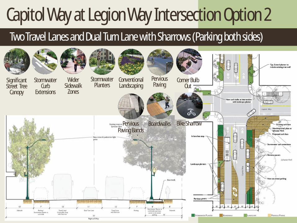
Capitol Way at Legion Way Intersection Option 2 Two Travel Lanes and Dual Turn Lane with Sharrows (Parking both sides)
Pervious Paving Bands
Pervious Paving
Stormwater Curb
Extensions
Boardwalks
Wider Sidewalk
Zones
Stormwater Planters
Significant Street Tree
Canopy
Corner Bulb Out
Conventional Landscaping
Bike Sharrow

Capitol Way from 9th to 10th Avenues
Initial Design Concepts
• Uphill slope; faster speeds
• Some recent improvements
• Poor pedestrian environment- no buffering from vehicles, buildings pulled back from street, etc.

Capitol Way from 9th to 10th Avenues: Option 1
Two Travel Lanes and Dual Turn Lane with Bike Lane and Sharrow
Pervious Paving Bands
Pervious Paving
Stormwater Curb
Extensions
Boardwalks
Wider Sidewalk
Zones
Stormwater Planters
Significant Street Tree
Canopy
Green Gutter
Corner Bulb Out
Bike Lane
Bike Sharrow

Capitol Way and 11th Avenue Intersection
Initial Design Concepts
• Buildings set back from corner on three corners
• Follow West Capitol Campus Preservation Landscape Master Plan along Capital frontage- Potential to complement improvements to Capitol Way
• Poor pedestrian and bicycle access
• Poor connection to Downtown
• Poor gateway appearance

Capitol Way at 11th Avenues Intersection Existing Conditions

Capitol Way at 11th Avenue Intersection: Option 1
Two Travel Lanes with Bike Lanes and Sharrow
Pervious Paving
Stormwater Planters
Green Gutter
Corner Bulb Out
Rain Garden Bike Lane
Conventional Landscaping
Bike Sharrow
Shared Space

Capitol Way at 11th Avenue Intersection: Option 2
Four Travel Lanes with Sharrows
Pervious Paving Bands
Pervious Paving
Shared Space
Pervious Paving
Stormwater Planters
Green Gutter
Corner Bulb Out
Rain Garden
Conventional Landscaping
Bike Sharrow
Shared Space

Exploring Choices & Preferences
Initial Design Concepts
• What future do you see for downtown Olympia?
• How can the design of streets serve this future vision? – What are priorities for allotting limited space
• Travel Lanes: number & direction
• Type of bicycle improvements
• Parking: amount & management
• Pedestrian and open space: amount & use
• Green infrastructure
– What is appropriate amount of congestion?

Greening Capitol Way
• Questions & Discussion
• We look forward to seeing you again on Wednesday
– Here at 6:30 pm
• Thank you!
Open House

Greening Capitol Way
September 29, 2014
Public Meeting #1 Introduction to Project and Initial Concepts