government of india planning...
TRANSCRIPT

0

1
Government of India
Planning Commission
Report of Working Group on
Flood Management and Region Specific Issues for XII Plan
New Delhi October, 2011

Foreword
Severe floods in the past as well as the recent floods in many States including Andhra Pradesh, Bihar, UP, Assam, West Bengal and Odisha which caused devastation and large submergence remind us of inadequacy of flood management measures. Therefore, concerted efforts are required to make a critical review of the existing flood management measures, capabilities of managers and related guidelines and policies together with state of the art technologies. I am sure that the strategies suggested in this report of the XII Plan Working Group on Flood Management and Region Specific Issues would enable the decision makers and the Planning Commission in adopting appropriate policies and measures required for flood management and coastal protection in our country.
I place on record the valuable suggestions made by various members and invitees of the Working Group especially Shri R.C. Jha, the then Member(RM) & Co-Chairperson of the Working Group, Shri S.P. Kakran, Member (RM) & Co-Chairman of the Working Group. I also appreciate the outstanding efforts made by Shri Devender Sharma, Commissioner (Ganga), MOWR & Member-Secretary, Shri K.N. Keshri, Chief Engineer(FM), CWC, Shri C. Lal, Director(FMP), CWC & Nodal Officer, Shri L.K. Taneja , Sr. Joint Commissioner ( Ganga), MOWR and Shri S.L. Meena, Deputy Director(FMP), CWC and their team of other officers in drafting and giving shape to the report.
October , 2011
( Prof. Nirmal Sengupta)
Chairman, IGIDR, Mumbai & Chairperson of Working Group on Flood Management & Region Specific Issues
(i)

ii
Preface
India has a peculiar geographical setting that there are floods in some parts
and droughts in other parts and sometimes they co-exist. Undoubtedly, India has made huge investment in flood control sector since 1951 but the fears about severity of floods and the agony brought out by them still persist and increasing in many cases. The planners involved in policy making as well as in strategies and their implementation need to have an outlook in order to come out with goal oriented approaches in a most reasonable and time bound manner with more cohesive inter-agency coordination and enhanced focus on integrated basin management.
I am sure the strategies suggested in this report would provide better tools
to manage floods both with long term and short perspectives. The suggestions about organizational strengthening and knowledge based management would enhance the capabilities of the departments to tackle the fury of floods to a reasonable degree. October , 2011
( S.P. Kakran) Member(RM), CWC &
Co-Chairperson of Working Group on Flood Management & Region Specific Issues
iii
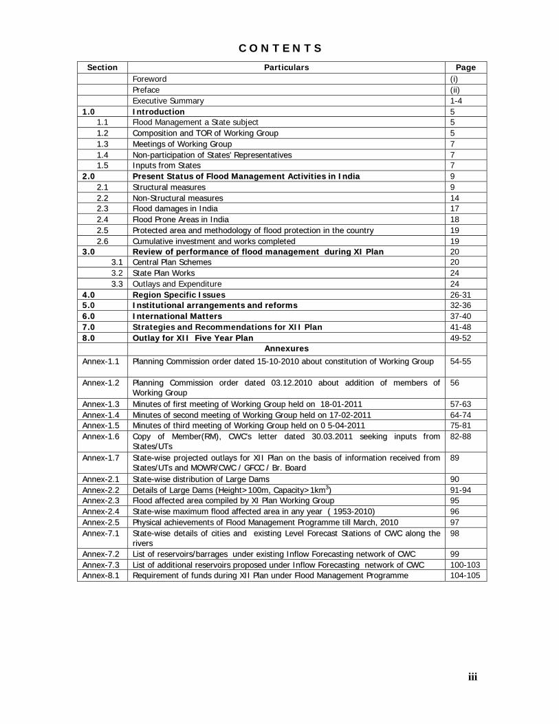
C O N T E N T S
Section Particulars Page Foreword (i) Preface (ii) Executive Summary 1-4
1.0 Introduction 5 1.1 Flood Management a State subject 5 11..22 CCoommppoossiittiioonn aanndd TTOORR ooff WWoorrkkiinngg GGrroouupp 5 11..33 MMeeeettiinnggss ooff WWoorrkkiinngg GGrroouupp 7 11..44 NNoonn--ppaarrttiicciippaattiioonn ooff SSttaatteess’’ RReepprreesseennttaattiivveess 7 11..55 IInnppuuttss ffrroomm SSttaatteess 7
22..00 PPrreesseenntt SSttaattuuss ooff FFlloooodd MMaannaaggeemmeenntt AAccttiivviittiieess iinn IInnddiiaa 9 22..11 SSttrruuccttuurraall mmeeaassuurreess 9 22..22 NNoonn--SSttrruuccttuurraall mmeeaassuurreess 14 22..33 FFlloooodd ddaammaaggeess iinn IInnddiiaa 17 22..44 FFlloooodd PPrroonnee AArreeaass iinn IInnddiiaa 18 22..55 PPrrootteecctteedd aarreeaa aanndd mmeetthhooddoollooggyy ooff fflloooodd pprrootteeccttiioonn iinn tthhee ccoouunnttrryy 19 22..66 CCuummuullaattiivvee iinnvveessttmmeenntt aanndd wwoorrkkss ccoommpplleetteedd 19
33..00 RReevviieeww ooff ppeerrffoorrmmaannccee ooff fflloooodd mmaannaaggeemmeenntt dduurriinngg XXII PPllaann 20 33..11 CCeennttrraall PPllaann SScchheemmeess 20 3.2 SSttaattee PPllaann WWoorrkkss 24 33..33 Outlays and Expenditure 24
44..00 Region Specific Issues 26-31 5.0 IInnssttiittuuttiioonnaall aarrrraannggeemmeennttss aanndd rreeffoorrmmss 32-36 66..00 IInntteerrnnaattiioonnaall MMaatttteerrss 37-40 77..00 Strategies and Recommendations for XII Plan 41-48 88..00 OOuuttllaayy ffoorr XXIIII FFiivvee YYeeaarr PPllaann 49-52 AAnnnneexxuurreess
AAnnnneexx--11..11 PPllaannnniinngg CCoommmmiissssiioonn oorrddeerr ddaatteedd 1155--1100--22001100 aabboouutt ccoonnssttiittuuttiioonn ooff WWoorrkkiinngg GGrroouupp 54-55
AAnnnneexx--11..22 PPllaannnniinngg CCoommmmiissssiioonn oorrddeerr ddaatteedd 0033..1122..22001100 aabboouutt aaddddiittiioonn ooff mmeemmbbeerrss ooff WWoorrkkiinngg GGrroouupp
56
AAnnnneexx--11..33 MMiinnuutteess ooff ffiirrsstt mmeeeettiinngg ooff WWoorrkkiinngg GGrroouupp hheelldd oonn 1188--0011--22001111 57-63 AAnnnneexx--11..44 MMiinnuutteess ooff sseeccoonndd mmeeeettiinngg ooff WWoorrkkiinngg GGrroouupp hheelldd oonn 1177--0022--22001111 64-74 AAnnnneexx--11..55 MMiinnuutteess ooff tthhiirrdd mmeeeettiinngg ooff WWoorrkkiinngg GGrroouupp hheelldd oonn 00 55--0044--22001111 75-81 AAnnnneexx--11..66 CCooppyy ooff MMeemmbbeerr((RRMM)),, CCWWCC’’ss lleetttteerr ddaatteedd 3300..0033..22001111 sseeeekkiinngg iinnppuuttss ffrroomm
SSttaatteess//UUTTss 82-88
AAnnnneexx--11..77 SSttaattee--wwiissee pprroojjeecctteedd oouuttllaayyss ffoorr XXIIII PPllaann oonn tthhee bbaassiiss ooff iinnffoorrmmaattiioonn rreecceeiivveedd ffrroomm SSttaatteess//UUTTss aanndd MMOOWWRR//CCWWCC // GGFFCCCC // BBrr.. BBooaarrdd
89
AAnnnneexx--22..11 SSttaattee--wwiissee ddiissttrriibbuuttiioonn ooff LLaarrggee DDaammss 90 AAnnnneexx--22..22 DDeettaaiillss ooff LLaarrggee DDaammss ((HHeeiigghhtt>>110000mm,, CCaappaacciittyy>>11kkmm33)) 91-94 AAnnnneexx--22..33 FFlloooodd aaffffeecctteedd aarreeaa ccoommppiilleedd bbyy XXII PPllaann WWoorrkkiinngg GGrroouupp 95 AAnnnneexx--22..44 SSttaattee--wwiissee mmaaxxiimmuumm fflloooodd aaffffeecctteedd aarreeaa iinn aannyy yyeeaarr (( 11995533--22001100)) 96 AAnnnneexx--22..55 PPhhyyssiiccaall aacchhiieevveemmeennttss ooff FFlloooodd MMaannaaggeemmeenntt PPrrooggrraammmmee ttiillll MMaarrcchh,, 22001100 97 AAnnnneexx--77..11 SSttaattee--wwiissee ddeettaaiillss ooff cciittiieess aanndd eexxiissttiinngg LLeevveell FFoorreeccaasstt SSttaattiioonnss ooff CCWWCC aalloonngg tthhee
rriivveerrss 98
AAnnnneexx--77..22 LLiisstt ooff rreesseerrvvooiirrss//bbaarrrraaggeess uunnddeerr eexxiissttiinngg IInnffllooww FFoorreeccaassttiinngg nneettwwoorrkk ooff CCWWCC 99 AAnnnneexx--77..33 LLiisstt ooff aaddddiittiioonnaall rreesseerrvvooiirrss pprrooppoosseedd uunnddeerr IInnffllooww FFoorreeccaassttiinngg nneettwwoorrkk ooff CCWWCC 100-103 AAnnnneexx--88..11 RReeqquuiirreemmeenntt ooff ffuunnddss dduurriinngg XXIIII PPllaann uunnddeerr FFlloooodd MMaannaaggeemmeenntt PPrrooggrraammmmee 104-105

1
Executive Summary In order to formulate XII five year plan, the Planning Commission constituted various Working Groups. The Working Group on Flood Management and Region Specific Issues was constituted under the Chairmanship of Prof. Nirmal Sengupta of IGIDR, Mumbai with Commissioner(Ganga), MOWR as Member- Secretary vide order No. 25(1)/A/2010-WR dated 15th October, 2010. This report has been prepared by the Working Group on Flood Management and Region Specific Issues. The report is presented in nine Sections as summarized below:
Section-1.0 : Introduction: This Section deals with the constitutional provisions about flood management. Flood management being within the purview of the States, the schemes for flood control & management are planned, funded and executed by the State Governments as per their own priority. The role of Central Government is basically technical, advisory, catalytic and promotional in nature. However, in order to assist the States in their efforts to minimize the adverse impacts of floods, some State Sector schemes are launched by the Ministry of Water Resources under Central Plan to provide them central assistance for undertaking such works in critical areas, the details of which are covered in this report.
The Working Group on Flood Management and Region Specific Issues set up by the Planning Commission met three times and sought inputs from all States and Union Territories (UTs) but only 16 States and 3 UTs provided inputs that too partially. Therefore, assessment of programmes and requirement of funds was done based on the inputs from States and the project reports referred by States to CWC/GFCC/Brahmaputra Board for techno-economic appraisal and funding under various plan schemes of the Ministry of Water Resources.
Section-2.0 : Present Status of Flood Management Activities in India: The section gives an account of structural and non-structural measures being undertaken in India. It has been emphasized that RBA in 1980 assessed the flood affected area in the country as 40 mha. The sum of maxima of flood affected areas in any year considered by RBA upto 1978 as 33.516 mha has gone upto 49.815 mha by 2010. However, there is no credible data base maintained by the States as required by a judicious criteria based on frequency of flooding, duration & depth of inundation etc. The flood damages reported by States from 1953 to 2010 have been projected at 2011 price level as Rs. 812500 crore approximately. The Group made an effort to compile the area
2
protected from floods but inputs were not received from all States/UTs. The information provided by Planning Commission about the expenditure incurred in various plans was used and it has been assessed that in flood control sector an expenditure of about Rs. 126000 crore ( at price level of 2011), has been made till date.
Section -3.0 : Review of Performance of Flood Management During XI Plan: This Section deals with the outlays and expenditure in the flood control sector both under central and state plans. The information was available for Central plan only and no information was provided for state plan. During XI Plan, three Central Sector schemes namely (i) River Management Activities and Works Related to Border Areas, (ii) Flood Forecasting and (iii) Farakka Barrage Project (under transport services) and one State Sector Scheme namely “Flood Management Programme” were operated under Flood Control Sector. The outlays and expenditure incurred under these schemes are given under para-3.1 of the Report.
Section-4.0: Region Specific Issues : This Section brings out the specific issues of the regions of Desert, Coastal saline, Non-coastal saline, Himalayas & Water logged areas. The outlays suggested in this report include the requirements of these regions except for the water logged areas for which the financial requirement is being addressed under separate progaramme on command area development.
Section-5.0: Institutional Arrangements and Reforms : This Section gives an account of the institutional mechanisms at centre and state levels which are involved in flood management in the country. For having integrated flood management in a most appropriate and expeditious manner, it has been recommended to strengthen these mechanisms appropriately. Although flood management is a state subject but central agencies are playing vital role in advising State Governments besides providing promotional financial support for flood management in critical areas. There is need for increased inter-agency coordination, capacity building programmes and policy decisions required about dispensing with the concept of plan and non-plan funds as well as removing restriction on recruitment of new field staff.
Section-6.0 : International Matters : A brief account of present international cooperation of India with neighbouring countries namely Nepal, China, Bhutan, Pakistan, Bangladesh in the matters of flood management in India and the status of construction of reservoirs on common border rivers has

3
been given in this Section. Need for expediting resolution of outstanding issues with neighbouring countries particularly construction of reservoirs in Nepal has been emphasized in order to ensure flood mitigation in India.
Section-7.0 : Strategies and Recommendations for XII Plan : This Section consists of various strategies and recommendations which aim at reforms for short as well as long term measures of flood management. The emphasis has been made on:
• Modernisation of flood forecasting network and its extension to other areas and reservoirs
• Automatic reservoir release information system
• Construction of reservoirs and diversion of flood water to water scarce areas
• Basin-wise integrated flood management approach
• Adoption of remote sensing based state of the art technologies in all spheres of flood management
• Use of new construction materials
Section - 8.0 : Outlay for XII Plan : Under the constraints of non-availability of requisite information from all the States and UTs, the Working Group has relied upon the details as available with Ganga Wing(MOWR), CWC, GFCC and Brahmaputra Board and recommends continuation of all the schemes namely (i) River Management Activities and Works Related to Border Areas, (ii) Flood Forecasting and (iii) Farakka Barrage Project (under transport services) under Central Sector and one Scheme namely “ Flood Management Programme” under State Sector during XII Plan. However, in order to enable the States to take up the major works of urgent nature expeditiously, it is recommended that during XII Plan, only critical flood management works with Benefit Cost Ratio more than 2.0 and costing Rs. 100 crore and above may be funded under the State Sector Scheme “ Flood Management Programme” and flood management / anti-sea erosion works below Rs. 100 crore may be undertaken by the State Governments through their state plans. During XII Plan, the flood management / anti-sea erosion works of UTs are proposed to be funded under the Central Sector Scheme renamed as “River Management Activities and Works Related to Border Areas and UTs” besides continuation of 100% funding of the bank protection /anti-erosion works on common border rivers. Thus, the Working

4
Group recommends a total outlay of Rs. 57575 crore under flood control sector for XII Five Year Plan ( 2012-17) as under:
SN Name of Programme / Scheme Outlay (Rs. crore)
A Central Plan (CP) I Central Sector (CS) (i) River Management activities and Works
Related to Border Areas and UTs 1250.00
(ii) Flood Forecasting 425.00(iii) Farakka Barrage Project (Transport Services) 800.00 Sub-total (CS) 2475.00II State Sector (SS) (i) Flood Management Programme 16000.00 Sub-total ( SS) 16000.00 Total (CP) 18475.00B State Plan (SP) 39100.00 Grand Total ( CP+SP) 57575.00

5
1.0 Introduction
Floods are considered as a recurrent phenomenon in many parts of the country, causing loss of lives and public property and bringing untold misery to the people, especially those in the rural areas. There is also a larger economic impact, as they derail economic activities, thus affecting growth. Over the years, several expert committees have studied the problems caused by floods and suggested measures for their management to the Government.
1.1 Flood Management a State Subject The subject of flood control, unlike irrigation, does not figure as such in any of the three legislative lists included in the Constitution of India. However, Drainage and Embankments, are two of the measures specifically mentioned in Entry 17 of List II (State List), reproduced below:
“Water, that is to say, water supplies, irrigation and canals, drainage and embankments, water storage and water power subject to the provision of entry 56 of List I(Union List).”
Entry 56 of List I (Union List) reads as follows:-
“Regulation and development of inter-State rivers and river valleys to the extent to which such regulation and development under the control of the Union is declared by Parliament by law to be expedient in the public interest..”
It may be seen that the primary responsibility for flood control lies with the States. A number of States have already enacted laws with provisions to deal with matters connected with flood control works. However, there exists a significant provision that the powers to be exercised are subject to Entry 56 of Union List. It may be pointed out that Entry 17 of List II(State List) quoted above does not cover land use involved in the administrative measures of dealing with reduction of flood losses viz. flood plain zoning.
1.2 Composition and TOR of Working Group on Flood Management
and Region Specific Issues
The Planning Commission constituted vide order no. 25(1)/A/2010-WR dated 15th October, 2010 and 25(1)/A/2010-WR dated 03.12.2010 (copies are kept at Annex-1.1& 1.2), a Working Group on Flood Management and Region Specific Issues headed by Prof. Nirmal Sengupta, IGIDR, Mumbai for formulation

6
of Twelfth Five Year Plan (2012-17). The Working Group has representatives from various NGO's and flood affected States besides members from the Central Organisations. The composition and TOR of Working Group are as under:
1.2.1 Composition of Working Group: 1. Prof. Nirmal Sengupta, IGIDR, Mumbai Chairperson 2. Member(River Management), Central Water Commission,
New Delhi Co-Chairperson
3. Shri Dinesh Kumar Mishra, Barh Mukti Abhiyan , Patna, Bihar
Member
4. Dr. Ravi Chopra, People's Science Institute, Dehradun Member 5. Shri Farhad Contractor, Founder Sambhav Trust,
Rajasthan Member
6. Shri Sandeep Virmani, MD, Hunnarshala Foundation, Bhuj, Gujarat
Member
7. Shri Chandan Mahanta, IIT, Guwahati Member 8 Principal Secretary, Water Resources Department,
Government of Uttarakhand, Dehradun Member
9 Principal Secretary, Water Resources Department, Government of Kerala
Member
10 Principal Secretary, Water Resources Department, Government of Rajasthan , Jaipur
Member
11 Principal Secretary, Water Resources Department, Government of Bihar, Patna
Member
12 Principal Secretary, Irrigation, Assam, Dispur Member 13 Joint Secretary, NDMA Member 14 Joint Secretary, Disaster Management, Ministry of Home
Affairs Member
15 Commissioner Ganga, Ministry of Water Resources, CGO Complex, New Delhi
Member-Secretary
Besides above, Chairman, Ganga Flood Control Commission, Chairman
Brahmaputra Board, Project Director, National Remote Sensing Centre (NRSC) and Mission Director, Mission on Geo-Spatial Applications, Deptt. Of Science & Technology were also invited during the meetings of the Working Group as Special Invitees.
Shri Devendra Sharma, Commissioner (Ganga ), Ministry of Water Resources
took over the charge of Member-Secretary of the Working Group in March 2011, on promotion of Shri S.P. Kakran as Member (D&R), CWC. Shri S.P.Kakran, Member (RM),CWC took over the charge of Co-Chairperson of the Working Group on 1st September, 2011 on promotion of Shri R.C. Jha as Chairman, CWC.

7
Shri C. Lal Director (FMP), CWC was nominated as the nodal officer from CWC for the Working Group.
1.2.2 Terms of reference of Working Group
The Terms of reference of Working Group are as under:
• Based on a critical review of the physical and financial performance of the flood management sector during the 11th Plan, suggest strategies, priorities and allocations for the 12th Plan.
• Based on a review of the present strategy for the regions of Desert,
Coastal saline, Non-coastal saline, Himalayas & Water logged areas, suggest a more effective way forward.
1.3 Meetings of Working Group During preparation of its Report, the Working Group met three times at New Delhi on the 18.01.2011, 17.02.2011 and 05.04.2011. During the meetings, the Working Group invited details of flood management plans from the State Governments including the States who could not be represented in Working Group. Detailed discussions were held on flood problems and measures undertaken / proposed by the States for controlling floods and mitigating their impacts. The minutes of meetings of Working Group are kept at Annex-1.3, 1.4 & 1.5. 1.4 Non-Participation of States Representatives
The Working Group has Principal Secretaries of five States, namely, Bihar, Assam, Rajasthan, Uttarakhand and Kerala as members representing the States. Vital inputs about the States from these representatives were expected in order to prepare a road map for flood management in a holistic manner. However, only the Principal Secretary of Government of Bihar attended first meeting and the Secretary (WRD) of Government of Assam attended the third meeting. Thus, the State Governments do not appear to be serious about the flood management issues in States as they do not provide even requisite information about the flood management works being executed in their States as well as funds required for XII Plan by them.
1.5 Inputs from States
Soon after constitution of the Working Group, all the State Governments / UTs were requested for providing inputs with regard to the achievements made so far in management of floods and their programmes / projections for meeting

8
the menace of floods, both on long term and short term basis. The copies of communications sent to the State Governments / UTs seeking relevant information as well as the formats of providing requisite information are placed at Annex 1.6.
Only 16 States and 3 UTs provided information that too partially. In absence
of specific inputs from the States, the indications made by the State Governments to CWC, GFCC and Brahmaputra Board while referring their flood management projects were utilized in reflecting the State-wise financial projections. The State-wise projected outlays for flood management works during XII Plan are summarised in Table-1.1 below :
Table-1.1 : State-wise projected outlays for flood management works
during XII Plan
SN State/UT Projected Outlay for XII Plan ( Rs. crore)
(A) STATES 1 Andhra Pradesh 1350 2 Arunachal Pradesh 660 3 Assam 5600 4 Bihar 3000 5 Chattisgarh 5000 6 Delhi (NCT) 0 7 Goa 30 8 Gujarat 40 9 Haryana 270 10 Himachal Pradesh 880 11 Jammu & Kashmir 14250 12 Jharkhand 50 13 Karnataka 1500 14 Kerala 5300 15 Madhya Pradesh 60 16 Maharashtra 30 17 Manipur 800 18 Meghalaya 400 19 Mizoram 70 20 Nagaland 500 21 Orissa 1890 22 Punjab 300 23 Rajasthan 100 24 Sikkim 570 25 Tamil Nadu 400 26 Tripura 2200 27 Uttar Pradesh 2180 28 Uttarakhand 360 29 West Bengal 7650 Total (States) 55440

9
2.0
Present Status of Flood Management activities
in India
Different measures have been adopted to reduce the flood losses and protect the flood plains. Depending upon the nature of works, flood protection and flood management measures may be broadly classified as under: (a) Engineering / Structural Measures (b) Non-Structural Measures (c) Catchment Area Treatment 2.1 Engineering /Structural Measures
The engineering measures for flood control which bring relief to the flood prone areas by reducing flood flows and thereby the flood levels are :
(a) an artificially created reservoir behind a dam across a river
(b) a natural depression suitably improved and regulated, if necessary or
(c) by diversion of a part of the peak flow to another river or basin, where such diversion would not cause appreciable damage.
(d) by constructing a parallel channel bypassing a particular town/reach of the river prone to flooding. The engineering methods of flood protection, which do not reduce the
flood flow but reduce spilling, are:
(a) embankments which artificially raise the effective river bank and thereby prevent spilling and
(b) channel and drainage improvement works, which artificially reduce the flood water level so as to keep water confined within the river banks and thus prevent spilling.
Some of the important measures for flood management are enumerated below: 2.1.1 Reservoirs
Reservoirs can moderate the intensity and timing of the incoming flood. They
store the water during periods of high discharges in the river and release it after

10
the critical high flow condition is over, so as to be ready to receive the next wave. Their effectiveness in moderating floods would depend on the reservoir capacity available at that time for absorbing the flood runoff and their proximity to the likely damage centre. They are operated with a carefully planned regulation schedule which takes into account both the safety of the dam and related structures and the safe carrying capacity of the lower reaches of the river in their present condition.
Reservoirs are more effective for flood management if, apart from the incidental moderation available for any type of storage on a river, specific flood space is earmarked, as in the case of DVC dams across the Damodar and its tributaries. India has constructed a total of 5125 large dams and 397 large dams are under construction (as on 08-09-2011) of which the State-wise details are given in Annex-2.1. There are 78 large dams having height above 100 m and capacity above 1 km3 out of which dedicated flood cushion has been provided in only 10 dams. The details of these 78 Dams are given in Annex-2.2.
Therefore, as a policy, a minimum flood cushion of 10% of the storage capacity should be provided in all new dams and, if affordable with respect to other purposes, providing even a flood cushion upto 20% could be considered. A portion of the capital cost of the reservoir should be allocated to flood control and shared by all beneficiary States.
The is a need to review operation schedule/rule curve to ensure space for flood moderation which can be filled for conservation at a later stage at the end of monsoon period.
In order to improve the efficiency of the reservoirs and improve the operation schedules for providing either incidental or specific flood moderation effects, arrangement for inflow forecasts should be made.
2.1.2 Detention Basins
Detention basins are usually formed by utilizing natural depressions/ swamps and lakes by improving their capacity by constructing encircling embankments and providing suitable devices for regulating the release of stored waters. Since, the land under the marshes or low depression may hardly require much compensation and rehabilitation measures, this method is relatively less expensive. The Ghaggar detention basin in Rajasthan, depressions available upstream of Srinagar City, on the left bank of river Jhelum, the Mokama Tal area in Bihar and Ottu, Bhindawas, Kotla lakes in Haryana and various beels / haors of Barak basin are examples of natural detention basins. The State Governments should identify possible good sites in the country for use as detention basins and should draw actionable programmes for use of these sites.

11
2.1.3 Embankments
Embankments (including ring bunds and town protection works) confine the flood flows and prevent spilling, thereby reducing the damage. These are generally cheap, quick and most popular methods of flood protection and have been constructed extensively in the past. These are reported to have given considerable protection at comparatively low costs, particularly in the lower reaches of large rivers. In many places, embankments may be the only feasible method of preventing inundation. By March, 2011, a total of about 35200 km of embankments have been constructed.
Embankments are generally designed and constructed to afford a degree of protection against floods of a certain frequency and intensity or against the maximum recorded floods till the time of their planning only (in the absence of detailed hydrological data for longer periods) depending upon the location protected and their economic justification. The raising and strengthening of existing embankments have also been taken up in many flood prone States. In order that this work is done more scientifically, it is necessary to adopt the flood frequency approach in design, taking into account the data of historical floods, which is now available.
Apart from the raising and strengthening works, erosion along the embankments and natural banks of the river systems has been a serious problem on which considerable expenditure has been incurred in the past. Particular mention could be made of the erosion problem of the embankment systems in Assam, Bihar, U.P, Punjab and West Bengal. The embankments, under serious attack by the major rivers and their tributaries, have to be suitably protected by spurs, pitching and other suitable anti-erosion measures. On many embankment systems like the Kosi embankment and Piprasi-Pipraghat embankment on the Gandak in Bihar, the river attack is so severe that the required protection measures cannot be covered under the normal maintenance works. Therefore, special maintenance programmes need to be drawn for such cases and adequate funds for the purpose should be earmarked by the State Governments.
Some embankments have provided positive benefits by ensuring sustained protection against floods and river spills while on the other hand, some embankments have, in certain reaches of the river, aggravated the flood problem by rising river bed levels, decreasing their carrying capacity, causing drainage congestion in the countryside and distorting the levels/gradient of the outfall points. A number of Committees constituted in various countries as well as in India have deliberated upon the utility of embankments as a means for flood

12
protection. Extreme views have emerged out of these. Many NGOs have voiced serious criticism about existing embankments. One is that problems of flood can be solved by removal of all the existing embankments and the other diametrically opposite being that construction of more and more lengths of the embankments and their raising and strengthening is the only practicable medium/short term solution for the flood problems. The reason for such wide divergence in opinion is obviously due to the inadequacy of sufficient number of performance evaluation studies of existing embankments and the divergent views on their performance.
Construction of embankments with proper roads on its top has been perceived as useful communication linkages and reliable surface network for areas that are liable to stand completely cut off during floods and thereafter. They could provide quick communication for facilitating better supervision and maintenance of the flood protection works and provide all weather communication facilities to the adjoining habitats. As such, they are often deemed as the life line during floods.
It is also recognized that apart from the benefits mentioned above, the embankments also have adverse effects such as interference with drainage, inability to stand erosion, etc. which should be considered before planning this measure for flood management. As such, this method of flood management may be undertaken only after carrying out detailed hydrological and other studies including adverse effects.
2.1.4 Channelisation of Rivers
Some of the States are proposing channelisation of rivers, at least in certain reaches, in the context of tackling the extensive meandering problems of the rivers, activating navigational channels and training these rivers into their original courses. While venturing to channelise rivers, thought must be given in allowing the river certain freedom to flow and right of way to pass its flood waters and silt load within its natural waterway. The dynamic nature of the rivers should be appreciated and preventive measures planned accordingly instead of pinning down the river by channelising. During XI Plan, major works of channelisation were undertaken in Punjab and Himachal Pradesh.
2.1.5 Channel Improvement
The method of improving the channel by improving the hydraulic conditions of the river channels by desilting, dredging, lining etc., to enable the river to

13
carry its discharges at lower levels or within its banks has been often advocated but adopted on a very limited extent because of its high cost and other problems.
Dredging operations of the Brahmaputra, which were undertaken in the early seventies on an experimental basis, were discontinued because of their prohibitive cost and limited benefits. Dredging in selected locations may perhaps be considered as a component of a package of measures for channel improvement to check the river bank erosion subject to techno-economic justification. It may be economically justifiable as a method for channel improvement where navigation is involved. Dredging is sometimes advocated for clearing river mouth or narrow constrictions.
2.1.6 Drainage Improvement
Surface water drainage congestion due to inadequacy of natural or artificial drainage channels to carry the storm water discharge within a reasonable period causes damages. It is often difficult to distinguish between flood and drainage congestion situations. This problem is rather acute in Andhra Pradesh, Bihar, Haryana, Punjab, Orissa, Uttar Pradesh, Assam and West Bengal, J&K, Gujarat and Tamilnadu. Therefore, improvement of drainage by construction of new channels or improvement in the discharge capacity of the existing drainage system is recommended as an integral part of the flood management programme in the country.
Stress has to be laid on improving the existing natural drainage system in the flood plains so that what should essentially be flooding of a few days should not get prolonged for months. In this context, the importance of the system ‘dhars’ or ‘old channels’, which efficiently served the function of draining away the spillage and surface flows generated by local rains, must be recognised. The blocking of these natural drainage channels, which is normally done in the name of “reclamation for development” because of paucity of land or vested interest, must be firmly discouraged. This applies also to all natural depressions, which are targeted for reclamation.
The adequacy of existing sluices and drainage channels should be reviewed in areas suffering from drainage congestion. If the capacities of existing sluices in embankments and drainage channels are inadequate, this should be improved by increasing the vents and improving outfall conditions.

14
2.1.7 Diversion of Flood Waters
Diversion of flood waters takes a part of the flood discharge to another basin or to the same basin downstream of the problem area or to a depression where it could be stored for subsequent release. This measure can be used to manage unusual floods around cities as in the case of flood spill channel near Srinagar and also in the lower reaches of a river near the sea as in the case of Krishna Godavari drainage scheme. Important schemes under execution or under planning are the supplementary drain in Delhi, the outfall channel in Jammu and Kashmir, the Damodar in the lower reaches in West Bengal, the Thottapally Spillway diversion in Kerala, the Kolleru lake diversion into the sea in Andhra Pradesh, the Kama-Pahari drain in Rajasthan and the Hulwaa drain in Uttar Pradesh.
2.1.8 Watershed Management
The watershed management measures include developing and conserving the vegetative and soil covers and also to undertake structural works like check-dams, detention basins, diversion channels, etc. In the watershed management of upper catchment, land treatment through afforestation and grass land development practices should be supplemented by structural works for retarding the water velocity and arresting silt.
2.2 Non-structural Measures
The non-structural methods endeavour to mitigate the flood damages by :
(a) Facilitating timely evacuation of the people and shifting of their movable property to safer grounds by having advance warning of incoming flood i.e. flood forecasting, flood warning in case of threatened inundation
(b) Discouraging creation of valuable assets/settlement of the people in the areas subject to frequent flooding i.e. enforcing flood plain zoning regulation.
Providing absolute protection to all flood prone areas against all magnitude of
floods is neither practically possible nor economically viable. Such an attempt would involve stupendously high cost for construction and for maintenance. Hence a pragmatic approach in flood management is to provide a reasonable degree of protection against flood damages at economic cost through a combination of structural and non-structural measures.

15
2.2.1 Flood Forecasting
The work of flood forecasting and warning in India is entrusted with the Central Water Commission (CWC). Flood Forecasting and flood warning in India was commenced in a small way in the year 1958 with the establishment of a unit in the Central Water Commission (CWC), New Delhi, for flood forecasting for the river Yamuna at Delhi. Presently, there are 878 Hydrological and Hydro-meteorological sites being operated by CWC across the country covering 20 river basins for gauge, discharge, sediment & water quality observations. The formulation of a forecast requires effective means of real time data communication network from the forecasting stations and the base stations (380 nos approx at present). Wireless Communication system installed in almost 550 stations is the backbone of the communication system required for flood forecasting activities. The activity of flood forecasting comprises of Level Forecasting and Inflow Forecasting. The level forecasts help the user agencies in deciding mitigating measures like evacuation of people and shifting people and their movable property to safer locations. The Inflow Forecasting is used by various dam authorities in optimum operation of reservoirs for safe passage of flood downstream as well as to ensure adequate storage in the reservoirs for meeting demand during non-monsoon period.
Presently, Flood forecasts are issued by CWC at 175 stations (28 Inflow
Forecast Stations + 147 Level Forecast Stations). Annually, about 6000 flood forecasts are issued by CWC during floods. The basin-wise and State-wise distribution of existing flood forecasting stations is given in Table-2.1 and 2.2.
Table-2.1: Basin-wise Existing Flood Forecasting Stations
Sl. No.
Name of River-systems Number of flood forecasting Stations Level Inflow Total
1 Ganga & Tributaries 77 10 87 2 Brahmaputra & Tributaries 27 - 27 3 Barak-System 05 - 05 4 Eastern-Rivers 08 01 9 5 Mahanadi 03 01 04 6 Godavari 14 04 18 7 Krishna 03 06 09 8 West flowing Rivers 09 06 15 9 Pennar 01 - 01
Total 147 28 175

16
Table-2.2: State-wise Existing Flood Forecasting Stations
Sl. No.
Name of State/UT Number of flood forecasting Stations Level Inflow Total
1 Andhra Pradesh 9 7 16 2 Assam 24 0 24 3 Bihar 32 0 32 4 Chhatisgarh 1 0 1 5 Gujarat 6 5 11 6 Haryana 0 1 1 7 Jharkhand 1 4 5 8 Karnakata 1 3 4 9 Madhya Pradesh 2 1 3 10 Maharashtra 7 2 9 11 Orissa 11 1 12 12 Tripura 2 0 2 13 Uttar Pradesh 34 1 35 14 Uttarakhand 3 0 3 15 West Bengal 11 3 14 16 Dadra & Nagar Haveli 1 0 1 17 NCT of Delhi 2 0 2 Total 147 28 175
In order to meet the requirement of real-time data collection, automatic
data transmission and flood forecast formulation, expeditious data / information dissemination, the Central Water Commission has undertaken modernization of its data collection and flood forecast network. During IX Plan, 55 telemetry stations in Mahanadi and Chambal Basins and two Earth Receiving Stations ( ERS) at Jaipur and Burla were established. During X Plan, modernization of 168 stations and 11 Modelling Centres was undertaken which has been completed in XI Plan. During XI Plan, additional 222 telemetry stations, 10 Modeling Centres and one more ERS at New Delhi are being installed. Besides, CWC has planned to modernize remaining existing stations as well as to extend flood forecasting network to cover A, B-1, B-2 and C-Class cities located near the rivers under level forecasting network and 160 additional reservoirs under inflow forecasting; which would help the concerned States in taking appropriate measures in advance for evacuation of people from flood affected areas and also to ensure optimum reservoir regulation.
2.2.2 Flood Plain Zoning
Flood-plain zoning is a concept central to flood plain management. This concept recognises the basic fact that the flood plain of a river is essentially its domain and any intrusion into or developmental activity therein must recognise the river’s ‘right of way’. Flood-plain zoning measures aim at demarcating zones or areas likely to be affected by floods of different magnitudes or frequencies and probability levels, and specify the types of permissible developments in these

17
zones, so that whenever floods actually occur, the damage can be minimised, if not avoided. Unfortunately, while all in principle generally endorse this approach, scant attention is given to it in actual practice, leading to increased flood damages. The Central Water Commission (CWC) has been continuously impressing upon the states the need to take follow-up action to implement the flood plain zoning approach. A model draft bill for flood plain zoning legislation was also circulated by the Union Government in 1975 to all the States.
There has been resistance on the part of the states to follow up the various aspects of flood plain management including possible legislation. The State of Manipur had enacted the flood plain zoning legislation way back in 1978 but the demarcation of flood zones is yet to be done. The state of Rajasthan has also enacted legislation for flood plain management in the State but enforcement thereof is yet to be done. The Government of Uttar Pradesh has decided to take suitable measures for regulating the economic/development activities in the flood plains. The Government of Bihar initiated action to prepare flood plain zoning maps, which are essential before any executive measures could be undertaken. The Government of West Bengal had intimated that a draft bill on flood plain zoning was under process. Other States are yet to take action for enactment of legislation.
2.2.3 Flood Proofing
Flood proofing measures adopted in India in the past, consisted of raising a few villages above pre-determined flood levels and connecting them to nearby roads or high lands. Under this programme, several thousand villages were raised in Uttar Pradesh in the fifties. In West Bengal and Assam also land-fills were attempted in villages to keep houses above flood levels even though nearby agricultural lands were liable to inundation. During X Plan, the Government of Bihar had also constructed, with Central assistance, the raised platforms for safety of the people in flood prone areas of North Bihar.
2.3 Flood Damages in India
The devastating floods not only result in loss of precious human lives, cattles and damage to public and private property but create a sense of insecurity and fear in the minds of people living in the flood plains. The after effects of flood like the agony of survivors, spread of epidemic, non availability of essential commodities and medicines, loss of the dwellings make floods most feared among the natural disasters being faced by human kind.

18
On an average (1953 to 2010), the floods resulted in an annual damage of more than Rs. 1800 crore besides the loss of precious human lives and cattle. The highlights of flood damages in India during the period of 1953-2010 are given in Table-2.3.
Table -2.3- Highlights of Flood Damages in India During the Period (1953-2010)
Note- The damage data for 2003 onwards is under validation by States. The figures are without
any escalation and not at current price level. At the price level of 2010, the total flood damages have been estimated as Rs. 8,12,500 crore (approx.) tentatively considering escalation @ 10% per annum on compounded basis.
2.4 Flood Prone Areas in India
Rashtriya Barh Ayog (RBA) -1980 assessed the total flood prone area in
the country as 40 mha by adding the maxima of flood affected area (34 mha) in any year to the area protected (10 mha) and deducting portion (4 mha) of the protected area included in the flood affected area due to failure of protection works. Subsequently, the XI Plan Working Group on Water Resources compiled the area liable to floods as 45.64 mha. The State-wise details of maxima of flood affected area (1953-78) as assessed by RBA and the floods affected area as compiled XI Plan Working Group on Water Resources are given in Annex –2.3. As complete inputs were not received by the Working Group, the data base maintained by CWC for the flood affected area has been utilized and the maximum flood affected area in any year as reported by States upto March, 2011 for the period from 1953 to 2010 has been compiled and given in Annex-2.4. It could be seen that the sum of the maxima of flood affected area
SN Item Unit
Average Annual
Damage
Maximum Damage
Extent Year 1 2 3 4 5 6
1 Area affected mha. 7.208 17.50 19782 Population affected million 3.19 7.045 19783 Human lives lost nos. 1612 11316 19774 Cattle lost nos. 89345 618248 19795 Cropped area affected mha. 3.679 15.180 20056 Damage to crops Rs crore 693.866 4246.622 20007 Houses damaged nos. (million) 1194637 3507542 19788 Damage to houses Rs crore 275.481 1307.89 19959 Damage to public utilities Rs crore 814.596 5604.46 200110 Total Damage to
crops, houses & public utilities
Rs crore 1804.419 8864.54 2000

19
reported by States to RBA for the period from 1953 to 1978 as 33.56 (rounded off to 34 mha) has gone upto 49.815 mha as per the data base maintained by CWC based on the flood damage data reported by States for the period from 1953-2010. 2.5 Protected area and methodology of flood protection in the
country
The State Governments are taking various measures for providing protection in the flood affected areas. As per the report of the XI Plan Working Group on Water Resources, an area of 18.22 mha has been provided reasonable degree of protection and the target for XI Plan was kept as 2.18 mha. During XI Plan, the Government of India has also provided central assistance to the State Governments under Flood Management Programme under State Sector besides the flood management works undertaken by the State Governments through their State Plans. A total of 218 works in 12 States have been reported as physically completed at site by respective State Governments as on 31-3-2011 through which additional flood prone area of 0.26 mha has been protected against floods and an old area of 1.61 mha has been restored. Thus, an area of 18.77 mha has been reported as protected upto March, 2011. The details of area protected through their State Plan works have not been provided by States. It is worth mentioning that the efforts of the State Governments have so far been concentrated mostly on undertaking short term measures like raising & strengthening of the existing embankments, anti-erosion measures, drainage improvement, desilting of channels and also construction of few new embankments. However, the aspects of undertaking long term measures like creation of reservoirs, etc. are missing from their programmes.
2.6 Cumulative Investment and Works Completed
Both the State Governments and the Central Government are making investments in flood sector for mitigating the impacts of floods right from the beginning of the Five Year Plans in 1951. An exercise has been carried out to bring the expenditure incurred in various Plans at the price level of 2011 which is worked out to about Rs.1,26,000 crore by considering an enhancement of the price by 10% every year and on compounded basis. Complete details about the achievements made in respect of various flood management works were sought from the State Governments but requisite information in this regard has not been received from the States due to which a consolidated idea of the works completed by the State Governments so far could not be made. However, The physical progress of flood protection works completed upto 31-03-2006 is given in Annex-2.5.

20
3.0 Review of Performance of Flood Management During XI Plan
3.1 Central Plan Schemes
3.1.1 Central Sector Schemes
(i) River Management Activities and Works Related to Border Areas:
The scheme on “ River Management Activities and Works Related to Border Areas” was formed as merger of various components of the Plan Schemes operated during X Plan with the objectives to meet the expenditure on (a) bilateral meetings with Nepal, Bhutan, China and Bangladesh, (b) joint hydrological observations with Bangladesh for sharing of Ganga waters under Ganga Water Treaty - 1996 with Bangladesh, (c) flood forecasting activities on rivers flowing from Nepal, Bhutan, China to India including payment to Government of China for provision of data of stations on river Sutlej and Brahmaputra, (d) expenditure on survey & investigation works in Nepal territory (e) establishment cost of GFCC, (f) grant-in-aid to the State Governments of Bihar, UP, West Bengal, Tripura and J&K for maintenance of the flood protection works and also grant-in-aid for river bank protection / anti-erosion works along International border with Bangladesh and (g) grant-in-aid to Brahmaputra Board for its establishment and execution of anti erosion works by Brahmaputra Board.
(a) Physical Progress - Meetings of bilateral mechanisms between Indian and Nepal, China, Bangladesh, Pakistan were held and dialogues on outstanding bilateral issues were furthered. The activities of observation of hydro-meteorological data in respect of Pancheshwar Multipurpose Project, joint hydrological observations on river Ganga and funding of GFCC and establishment component of Brahmaputra Board, are of continuing nature. Dialogues were held with Nepal on setting up of Pancheshwar Development Authority for finalization of Joint DPR of Pancheshwar Multipurpose Project. The activities for joint field investigations and preparation of DPR of Sapta Kosi High Dam which got affected due to law and order situation in Nepal, were continued and the same would spill over to XII Plan. The arrangements for receipt of hydrological data of hydro-meteorological stations in Nepal and China were continued. Besides, maintenance of flood protection works of Kosi

21
and Gandak were continued. Three bank protection works on river Mahananda and dredging of river Ichhamati have been completed. About 50% of bank protection works on rivers Attrai, Punarbhava, Tangon, Nagar etc in West Bengal and 50% of works on river Feni in Tripura along international border with Bangladesgh have been completed.
(b) Financial Progress - Out of the approved outlay of Rs.601.00 crore
for XI Plan, an expenditure of Rs.576.93 core was incurred upto 31.3.2011. In view of above, the outlay has been revised to Rs. 820.00 crore which is under approval.
(ii) Flood Forecasting :
(a) Physical Progress - The activity of flood forecasting has been entrusted with the Central Water Commission for which the flood forecasts are provided to the State Governments at 175 stations comprising of level forecasts for 147 stations and inflow forecasts for 28 reservoirs/barrages in the country. The flood warnings issued by CWC are utilized by the local administration and other agencies in planning suitable administrative measures including evacuation of the people from flood affected areas to safer locations. The expenditure on these activities is being met from the Plan Scheme “Flood Forecasting” which covers the expenditure on routine activities undertaken for flood forecasting and strengthening of field offices of CWC. CWC has been making continuous endeavor for modernization of its flood forecasting network. During XI Plan, the scheme consisted of spillover works of the modernization undertaken during X Plan and installation of automatic system of data collection, transmission, flood forecasting and flood information dissemination with state-of-the-art satellite based data transmission technology. The spillover works of X Plan for installation of telemetry system at 168 stations and establishment of 11 modelling centres were completed during XI Plan. Besides, the works of installation of automatic system at additional 222 stations, one Earth Receiving Station at New Delhi and setting up of 10 modelling centres have been undertaken and the same are in progress. The activities of issuing flood forecasts at 175 stations and their dissemination to the local administration were continued. (b) Financial Progress - During XI Plan, an outlay of Rs.130.00 crore was approved out of which an expenditure of Rs.69.58 crore has been incurred upto 31.3.2011.

22
(iii) Farakka Barrage Project : (a) Physical Progress – The Farakka Barrage Project was commissioned by Government of India in the year 1975 with the objective of preservation and maintenance of Kolkata Port by diverting water from river Ganga to Bhagirathi / Hughly and also to improve the navigability of the river system for inland waterway from Haldia to Allahabad via Farakka Barrage in West Bengal. The sharing of water between India and Bangladesh is also ensured at Farakka Barrage Project under the Indo-Bangladesh Treaty of 1996. The works undertaken under this Scheme are basically for operation & maintenance of the Farakka Barrage Project and to meet the expenditure on river training and bank protection works. Although, the Scheme is basically a transport sector Scheme, but for the purpose of expenditure, the Scheme is covered under the Flood Control Component of the Ministry of Water Resources. (b) Financial Progress - During XI Plan an outlay of Rs.350.00 crore was approved for this Scheme. Out of which, an expenditure of Rs.200.00 crore has been incurred till 31.3.2011.
3.1.2 State Sector Scheme
Flood Management Programme : During XI Plan, the Government of India launched a Flood Management Programme for providing central assistance to the States for undertaking works related to river management, flood control, anti-erosion, drainage development, flood proofing, restoration of damaged flood management works and anti-sea erosion. The Ministry of Water Resources formulated detailed guidelines for providing central assistance to the State Governments. As per the guidelines, after techno-economically appraisal and mandatory clearances as per extant norms of the Planning Commission, the works are approved by an Empowered Committee headed by the Secretary (Exp), Ministry of Finance and included under Flood Management Programme. The funds are released by the Ministry of Finance to the State Governments. (a) Physical Progress - A total of 406 nos. flood management / anti-sea erosion works of various State Governments were included under the Programme out of which 218 works have been completed upto 31-03-2011 which have provided protection to old flood affected area of 16.18 lakh ha and new area of 18.767 lakh ha. These works have benefitted

23
total population of 197.803 lakh in the concerned States. The details are given in Table-3.1 below:
Table-3.1: STATE-WISE DETAILS OF AREA PROTECTED/ RESTOREDAND POPULATION BENEFITED (as on 31.03.2011)
Sl. No.
State No of Schemes
Completed
Area protected ( in lakh ha)
PopulationBenefited(in Lakh) Old
Area restored
New Area Protected
Total
1 Arunachal. Pradesh
11 0.000 0.566 0.566 0.697
2 Assam 65 3.864 1.007 4.871 97.848
3 Bihar 26 10.237 0.285 10.522 70.9224 Goa 1 0.002 0.000 0.002 0.1505 Manipur 12 0.000 0.280 0.280 1.5816 Nagaland 5 0.000 0.004 0.004 0.6007 Orissa 59 1.474 0.082 1.556 7.2058 Sikkim 22 0.000 0.201 0.201 2.3979 Uttar Pradesh 5 0.443 0.096 0.539 4.00910 Uttrankhand 3 0.000 0.001 0.001 0.05311 West Bengal 7 0.160 0.063 0.223 12.32812 Tripura 2 0.000 0.002 0.002 0.013
Total 218 16.180 2.587 18.767 197.803
(b) Financial Progress - Initially, an outlay of Rs. 8000 crore was approved in principle which was subsequently revised to Rs. 2715 crore. An Empowered Committee, headed by Secretary (Exp.), Ministry of Finance, was set up to examine the proposals of the State Governments and select the schemes depending upon critical / emergent situations and the availability of annual budget / plan outlay to ensure cost-effective solutions. During XI Plan, a total of 406 nos. of schemes with an estimated cost of Rs.7574.80 crore were included for funding under Flood Management Programme with central share of Rs. 5984.19 crore. Out of this centre share, an amount of Rs. 2667.65 crore was released upto 31-03-211 and allocation in BE 2011-12 is Rs. 1600.00 crore. Thus, the anticipated expenditure during XI Plan would be Rs.4267.65 crore. The details of schemes included and funds released are given in Table-3.2.

24
Table-3.2: State-wise schemes approved and central assistance released under Flood Management Programme During XI Plan
Rs. in croreSl. No.
State Schemes Included under FMP Funds Released (as on
31.08.2011) Nos. Total
Cost Central Share
1 Arunachal Pradesh 21 107.33 96.55 57.852 Assam 100 996.14 896.50 508.92
3 Bihar 43 1370.42 1027.80 502.004 Chattisgarh 3 31.13 23.34 0.005 Goa 2 22.73 17.05 9.986 Gujarat 2 19.79 14.84 2.007 Haryana 1 173.75 130.31 46.91
8 Himachal Pradesh 3 225.32 202.78 117.459 Jammu & Kashmir 23 331.23 298.10 136.0510 Jharkhand 3 39.30 29.47 10.5311 Karnataka 3 59.46 44.59 0.0012 Kerala 3 249.74 187.30 22.4313 Manipur 22 109.34 98.41 52.6514 Mizoram 2 9.13 8.22 2.0615 Nagaland 11 49.35 44.38 11.2116 Orissa 66 155.42 116.56 94.7417 Puducherry 1 139.67 104.75 7.5018 Punjab 5 153.40 115.04 34.5919 Sikkim 24 86.21 77.59 63.5720 Tamilnadu 5 635.54 476.66 59.8221 Tripura 11 26.57 23.92 16.2222 Uttar Pradesh 25 659.82 494.86 203.6823 Uttrankhand 10 101.93 88.61 28.0124 West Bengal 17 1822.08 1366.56 591.08
Total 406 7574.80 5984.19 2579.22Spilled over works of X Plan 89.79
Grand Total 2669.01
3.2 State Plan Works – The Working Group sought information from all the
States and UTs about the physical and financial progress / achievements of the works executed by them. No inputs were received in this regard.
3.3 Outlays and Expenditure – The XI Plan (2007-12) started from April, 2007 and currently the fifth year (2011-12) is in progress. Thus, the final figure of expenditure for the current FY: 2011-12 will be available only after 31-3-2012. The figures of expenditure for the years 2007-08, 2008-09, 2009-10 and 2010-11 as provided by Planning Commission have been

25
considered for review. The Plan-wise outlays recommended by the XI Plan working Group and outlays finally approved the Planning commission are given in Table-3.3.
Table-3.3: Scheme-wise Approved Outlay and Anticipated Expenditure During XI Plan
Rs. in crore SN Name of Programme / Scheme Approved Outlay Anticipated
Expenditure A Central Plan (CP) I Central Sector (CS) (i) River Management activities and Works Related to
Border Areas 601.00* 754.71
(ii) Flood Forecasting 130.00 105.58(iii) Farakka Barrage Project ( Transport
Services) 350.00 270.00
Sub-total (CS) 1081.00 991.70II State Sector (SS) (i) Flood management Programme 2715.00 4267.65 Sub-total ( SS) 2715.00 4267.65 Total ( CP) 3796.00 5269.35B State Plan (SP) @ @ Grand Total ( CP+SP) @ @ * under revision to Rs. 820.00 Crore @ Information not received from Planning Commission.
26
The Working Group was asked to study the specific flood related issues for the following broad regions of India:
• Desert region • Coastal saline Region • Non – coastal saline Region • Himalayan Region • Water logged areas The flood problems are generally classified by the States on the basis of
flood prone areas and the actions to mitigate such problems. The State Governments do not deal with floods for different regions as mentioned above. Therefore, no details are available for above categories. The flood problems of the above regions are, however, covered in the following paragraphs: 4.1 Desert Region : About 12% of India’s geographical area is suffering from the threat of desertification in the arid north-west and in a broad semi-arid zone from Punjab in north-west to Tamil Nadu in the south. The desert region covers the States of Rajasthan, Haryana, Gujarat, Himachal Pradesh, J&K, Andhra Pradesh and parts of Karnataka and Tamil Nadu. In these States, an area of 45.79 mha has been identified as desert area and a Desert Development Programme is under implementation for restoration of ecological balance by conserving, developing and harnessing, water, livestock and human resources aiming at economic development of the village community. The specific measures have not been indicated by the concerned States. However, the requirement of funds for undertaking flood related issues has been included in the overall size of the XII Plan recommended in this Report. 4.2 Coastal Saline Region - India’s mainland has a coastline of about 5400 km and including A&N and Lakshadweep islands the total coastline is about 7500 km. Nearly 250 million people live within a distance of 50 km from the coast. Coastal environment plays a vital role in nation’s economy by virtue of the resources, productive habitats and rich biodiversity. The coastal areas are assuming greater importance in recent years, owing to increasing human population, urbanization and accelerated developmental activities.
Some of the general problems along the Indian coast which require
engineering interventions are silting up of entrance channels, flooding during storm surge, sand bar formation near mouths of inlets, rivers and estuaries and erosion of the coast. While all the problems need to be addressed, coastal erosion is the major concern. All the maritime states/UT are facing problem of coastal erosion in varying magnitude. As per information received from maritime
4.0 Region Specific Issues
27
States/UTs about 1650 km in total and 1500 km of the mainland are affected by erosion. Out of these around 830 km of critically affected area has been protected and around 820 km are yet to be protected. The causes of erosion are either natural or man-made. Sometimes, it is a combination of both. It is to be noted that Coastal Protection Works are extremely investment intensive and have to sustain hostile and extremely dynamic marine environment. Hence prioritization of such works at National level is of utmost requirement. Prioritization and especially the development of optimum and sustainable solutions to mitigate/combat coastal erosion require vast set of data. 4.3 Non-Coastal Saline Region – As the requisite details about specific issues in non-coastal saline regions have not been received from the State Governments, it is presumed that the requirement of flood management measures in non-coastal saline regions is included in the overall projections made in this Report on the basis of details furnished by the State Governments.
4.4 Himalayan Region - This region consists of sub-regions of Brahmaputra and Ganga. The problems in these sub-regions are briefly mentioned below:
4.4.1 Brahmaputra Sub-Region - This consists of the rivers Brahmaputra and Barak and their tributaries, and covers the States of Assam, Arunachal Pradesh, Meghalaya, Mizoram, Northern parts of West Bengal, Manipur, Tripura and Nagaland. The catchments of these rivers receive very heavy rainfall ranging from 110 cm. to 635 cm. (45" to 250") in a year which occurs mostly during the months of May / June to September. As a result, floods in this region are severe and quite frequent. Further, the rocks of the hills, where these rivers originate are friable and susceptible to erosion and thereby cause exceptionally high silt charge in the rivers. In addition, the region is subject to severe and frequent earthquakes which cause numerous landslides in the hills and upset the regime of the rivers. The predominant problems in this region are the flooding caused by spilling of rivers over their banks, drainage congestion and tendency of some of the rivers to change their courses. In recent years, the erosion along the banks of the Brahmaputra has assumed serious proportions.
Considering the individual States in the region, the main problems in
Assam are the inundation caused by spilling of the Brahmaputra and the Barak and their tributaries and also the erosion along the Brahmaputra river. In northern parts of West Bengal, the rivers Teesta, Torsa, Jaldakha and Mahananda are in floods every year and inundate large areas. These rivers also carry considerable amount of silt and have a tendency to change their courses. The rivers in Manipur spillover their banks frequently. The lakes in territory get

28
filled up during the monsoon and spread over large marginal areas. In Tripura, there are the problems of spilling and erosion by rivers.
4.4.2 Ganga Sub-Region - The river Ganga and its numerous tributaries of which some of the important are the Yamuna, the Sone, the Ghaghra, the Gandak, the Kosi and the Mahananda, constitute this river region. It covers the States of Uttaranchal, Uttar Pradesh, Jharkand, Bihar, south and central parts of West Bengal, parts of Haryana, Himachal Pradesh, Rajasthan, Madhya Pradesh and Delhi. The normal annual rainfall of this region varies from about 60 cm to 190 cm. (25" to 75") of which more than 80% occurs during the south west monsoon. The rainfall increases from west to east and from south to north.
The flood problem is mostly confined to the areas on the northern bank of
the river Ganga. The damage is caused by the northern tributaries of the Ganga by spilling over their banks and changing their courses. Even though the Ganga is a mighty river carrying huge discharges of 57,000 to 85,000 cumec (2 to 3 million cusec), the inundation and erosion problems are confined to relatively few places. In general, the flood problem increases from the west to the east and from south to north. In the North western parts of the region, there is the problem of drainage congestion. The drainage problem also exists in the southern parts of West Bengal.
The flooding and erosion problem is serious in the States of Uttar Pradesh,
Bihar and West Bengal. In Rajasthan and Madhya Pradesh, the problem is not so serious but in some of the recent years, these states have also experienced some incidents of heavy floods.
In Bihar, the floods are largely confined to the rivers of North Bihar and
are, more or less, an annual feature. The rivers such as the Burhi Gandak, the Bagmati, the Kamla Balan, other smaller rivers of the Adhwra Group, the Kosi in the lower reaches and the Mahananda at the eastern end spill over their banks causing considerable damage to crops and dislocation of traffic. High floods occur in the Ganga in some years causing considerable inundation of the marginal areas in Bihar. During the last few years erosion has also been taking place along the Ganga and is now prominent on the right bank immediately downstream of the Mokameh bridge and in the vicinity of the Mansi Railway Station on the left bank.
In Uttar Pradesh, the flooding is frequent in the eastern districts, mainly
due to spilling of the Rapti, the Sharada, the Ghaghra and the Gandak. The problem of drainage congestion exists in the western and north western areas of Uttar Pradesh, particularly in Agra, Mathura and Meerut districts. Erosion is experienced in some places on the left bank of Ganga, on the right bank of the Ghaghra and on the right bank of the Gandak.

29
In Uttarakhand, many small tributaries of Ganga and Yamuna are flowing through Distt. Dehradun and Haridwar. Similarly, numbers of tributaries of river Ramganga are also flowing across Distt. Nainital and Udhamsing Nagar. The discharge and the velocity in these tributaries during monsoon are enormous (i.e. in the range of 4-6 m/s) due to steep bed gradient. These tributaries pass through some of the thickly populated areas in the above districts. These rivers and their tributaries are causing heavy erosion to the valuable land and properties along the river every year during the flood.
In Haryana, flooding takes place in the marginal areas along the Yamuna and the problem of poor drainage exists in some of the south western districts. In south and central West Bengal, the Mahananda, the Bhagirathi, the Ajoy, the Damodar etc. cause flooding due to inadequate capacity of river channels and tidal effect. There is also the problem of erosion of the banks of rivers and on the left and right banks of Ganga upstream and downstream respectively of the Farakka barrage. In Delhi, a small area along the banks of the Yamuna is subject to flooding by river spills. In addition, local drainage congestion is experienced in some of the developing colonies during heavy rains. 4.4.3 North West River Region - The main rivers in this region are the Sutlej, the Beas, the Ravi, the Chenab and the Jhelum, the tributaries of Indus, all flowing from the Himalayas. These carry quite substantial discharges during the monsoon and also large volumes of sediment. They change their courses frequently and leave behind vast tracts of sandy waste. The region covers the State of Jammu and Kashmir, Punjab and parts of Himachal Pradesh, Haryana and Rajasthan. Compared to the Ganga and the Brahmaputra river region, the flood problem is relatively less in this region. The major problem is that of inadequate surface drainage which causes inundation and water logging over vast areas. At present, the problem in the States of Haryana and Punjab are mostly of drainage congestion and water logging. Floods in parts of Rajasthan were rare in the past. The Ghaggar river used to disappear in the sand dunes of Rajasthan after flowing through Punjab and Haryana. The Jhelum floods occur periodically in Kashmir causing a rise in the level of the Wullar Lake thereby submerging marginal areas of the lake. 4.4.4 Central India and Deccan Region - The important rivers in this region are the Narmada, the Tapi , the Mahanadi, the Godavari, the Krishna and the Cauvery. These rivers have mostly well defined stable courses. They have

30
adequate capacity within the natural banks to carry the flood discharge except in the delta area. The lower reaches of the important rivers on the East Coast have been embanked, thus largely eliminating the flood problem.
This region covers all the southern States namely Andhra Pradesh, Karnataka, Tamil Nadu and Kerala and the State of Orissa, Maharashtra, Gujarat and parts of Madhya Pradesh. The region does not have serious problem except for some of the rivers of Orissa State namely the Brahmini, the Baitarni, and the Subarnarekha. The Delta areas of the Mahanadi, Godavari and the Krishna rivers on the east coast periodically face flood and drainage problems in the wake of cyclonic storms.
The Tapi and the Narmada are occasionally in high floods affecting areas in the lower reaches in Gujarat. The flood problem in Andhra Pradesh is confined to spilling by the smaller rivers and the submergence of marginal areas along the Kolleru Lake. In addition , there is a drainage problem in the deltaic tracts of the coastal districts.
In Orissa, damage due to floods is caused by the Mahanadi, the Brahmani and the Baitarni which have a common delta where the flood waters intermingle and when in spate simultaneously cause considerable havoc. The problem is accentuated when the flood synchronizes with high tides. The silt deposited constantly by these rivers in the delta area raises the flood level and, the rivers often over flow their banks or break through new channels causing heavy damage. The lower reaches of the Subarnarekha are affected by floods and drainage congestion. The small rivers of Kerala when in high floods cause considerable damage though occasionally. Cyclonic storms in the eastern coast of Tamilnadu during the north eastern monsoon had also caused occasionally severe damages in the coastal districts of the state.
4.5 Water Logged Areas - Water logging is one of the major problems of land degradation in India. Unscientific management of soil, water and crops in irrigated lands and obstruction of natural drainage systems by various developmental activities are the main factors responsible for disrupting the balance of inflow and outflow of water, leading to water logging. While irrigation has increased by leaps and bounds, its attendant problem of water logging is now plaguing substantial area of agricultural lands.
Water logging may be a result of both natural and man-made factors. Natural factors may include poor natural drainage as a consequence of unfavourable sub-soil geology like existence of hardpan at shallow depths; spilling of rivers resulting in submergence of agricultural lands; heavy storm rainfall coupled with poor natural drainage etc. Waterlogging is, however, caused

31
mainly because of man made factors like deforestation and poor upkeep of watersheds; developmental activities such as construction of roads, bridges, railway lines and buildings resulting in choking of natural drainage; hydraulic pressure of water from upper irrigated areas resulting in seepage outcrop in low lying areas; introduction of irrigation without taking into account characteristics of soils and sub-soils for their irritability; seepage from canals, distributaries and watercourses; excess application of irrigation water particularly in the initial years when the command is not fully developed; poor “On Farm Water Management” resulting in poor water-application efficiencies; unrealistic cropping patterns tilted in favour of water intensive crops; lack of night irrigation in some commands; inadequate drainage and poor maintenance of existing drainage systems and outlets; lack of conjunctive use of surface and ground water etc.
The National Water Policy, 2002 stresses on participatory approach in water resources management. It has been recognized that participation of beneficiaries in water resource management will help considerably in proper upkeep of irrigation system and optimal utilization of irrigation water. The evaluation made in the past has revealed that the CAD Programme made positive impact on various important indicators, like increase in the irrigated area, productivity and production, irrigation efficiency etc. Despite efforts for efficient irrigation water management, the problem of water logging has surfaced in many irrigated commands.
The National Commission on Agriculture assessed that an area of 6 mha in the country is waterlogged which was reassessed to be 8.53 mha by the Ministry of Agriculture in 1984-85. The Working Group on Problem Identification in Irrigated Areas with Suggested Remedial Measures constituted by the Ministry of Water Resources in 1986, which submitted its Report in 1991, made an assessment of the water logged areas, saline areas and alkaline areas as 2.46 m.ha, 3.06 m.ha and 0.24 m.ha respectively (total 5.76 m.ha.).
For comprehensive flood and drainage management, it is necessary to reassess the extent of waterlogged area in the country during and after the monsoon particularly utilizing the Satellite Imageries. Each State needs to organise this activity in right earnest to lead to formulation of effective drainage disposal measure.
Under the component on reclamation of water logged areas, 482 schemes in nine States, namely, Bihar, Gujarat, Madhya Pradesh, Jammu & Kashmir, Karnataka, Kerala, Maharashtra, Orissa and Uttar Pradesh have been approved for reclamation of 63,566 ha. of water logged area. Out of this, an area of about 50,249 ha. has been reported to be reclaimed by these States up to March 2009.

32
5.0 Institutional Arrangements and Reforms
As per constitutional provisions, the subject ”Flood Management” falls within the purview of the States. The flood control & management schemes are planned, investigated and implemented by the State Governments with their own resources as per priority within the State. The Union Government renders assistance to States which is technical, advisory, catalytic and promotional in nature. Therefore, a two tier system of flood management exists in India as briefly described below: 5.1 State Government Mechanism - The State Level Mechanism includes the Water Resources Departments, State Technical Advisory Committee and Flood Control Board. In some States, the Irrigation Departments and Public Works Departments look after flood matters. 5.2 Central Government Mechanism – The Union Government has set up following organizations and various expert committees to enable the State Governments in addressing flood problems in a comprehensive manner: 5.2.1 Central Water Commission (CWC) – The Government of India set up Central Water Commission in 1945 for achieving the goal of furthering and promoting measures of flood control, conservation and utilization of water resources throughout the country in the areas of beneficial uses, irrigation and hydropower generation, flood management and river conservation. As a national apex engineering organisation in the field of water resources development, the CWC with its vast experience gained in its strides towards progress in more than six decades, has developed considerable know-how in planning, investigation, management and design of water resources development schemes and made valuable contribution in the country’s remarkable progress in this field besides sharing the expertise with developing nations of the world. The CWC plays direct role in real time collection of flood data, flood forecasting and dissemination of flood forecasts to the local administration for planning suitable administrative measures including evacuation of people from flood affected areas to the safer locations. 5.2.2 Brahmaputra Board – The Government of India set up Brahmaputra Board under Brahmaputra Board Act, 1980 (46 of 1980) under the then Ministry of Irrigation (now Ministry of Water Resources) The jurisdiction of Brahmaputra includes all NE States including Sikkim and North Bengal. The main functions of Brahmaputra Board are as under :
• Survey and investigations in Brahmautra and barak valley.
33
• Preparation of master plans to control floods, bank erosion, improvement of drainage system.
• Preparation of DPRs for dams and other projects • Standard specifications for construction, operation and maintenance of
dams. • Construction of multipurpose dams and maintenance thereof. • Any other function for implementation of Brahmaputra Board Act-1980.
Brahmaputra Board prepared master plans for Brahmaputra under Phase-I,
Barak under Phase-II and under Phase-III 38 tributaries of Brahmaputra, 8 rivers of Tripura and 3 south flowing rivers of Meghalaya. The Board has also proposed to prepare master plans for the remaining parts of NE Region. South flowing rivers in Sikkim and Northern parts of West Bengal in Brahmaputra Basin. Besides this, the Board has continued survey and investigations for preparation of master plans for tackling the problems of flood, erosion and drainage congestion including DPRs for multipurpose projects. The Government of India has so far approved the master plans under Phase-I and II. Under Phase-III, the Government has also approved 34 master plans out of 52 prepared by the Board. The Board identified 21 multipurpose projects for investigation and preparation of DPRs out of which Pagladiya Dam Project was approved by GOI. Out of 34 drainage developments identified by the Board, 10 schemes have been approved by the Ministry of Water Resources for execution. The Harang Drainage Development Scheme is nearly completion and other 8 drainage development schemes are proposed to be completed during XI Plan. 5.2.3 Ganga Flood Control Commission - The Ganga Flood Control Commission (GFCC) was set up by Government of India in 1972 for preparation of comprehensive plan of flood control for Ganga Basin and to draw out a phased coordinated programme of implementation of works and monitoring & appraisal of flood management schemes of Ganga basin States. The GFCC has prepared comprehensive plans of flood management of the 23 sub-basins in the Ganga Basin besides drawing out a phased programme of implementation of these works to proper standards, examination and monitoring of various flood management schemes in the Ganga Basin States. 5.2.4 National Disaster Management Authority (NDMA) - For prevention and mitigation of effects of disasters including flood disasters and for undertaking a holistic, coordinated and prompt response to any disaster situation, the Government of India has set up a National Disaster Management Authority (NDMA) in 2005 under the Chairmanship of Hon’ble Prime Minister of India. The functions of the NDMA are :
(i) lay down policies on disaster management; (ii) approve national Plan; (iii) approve plans prepared by the Ministries or departments of the
Government of India in accordance with the National Plan;

34
(iv) lay down guidelines to be followed by the State Authorities in drawing up the State Plan;
(v) lay down guidelines to be followed by the different Ministries or departments of the government of India for the purpose of integrating the measures for prevention of disaster or the mitigation of its effects in their development plans and projects;
(vi) coordinate the enforcement and implementation of the policy and plan for disaster management;
(vii) recommend provision of funds for the purpose of mitigation; (viii) provide such support to other countries affected by major disasters
as may be determined by the central Government; (ix) take such other measures for the prevention of disaster, or the
mitigation, or preparedness and capacity building for dealing with the threatening disaster situation or disaster as it may consider necessary;
(x) lay down broad policies and guidelines for the functioning of the National Institute of Disaster Management.
The NDMA has issued guidelines in January, 2008 for management of
floods and the roles of various Central and State agencies have been specified for preparation of flood mitigation plans and taking relief measures during flood disasters. 5.3 Institutional Reforms – The following institutional reforms are suggested for effective flood management in the country : 5.3.1 Expedite setting up of River Basin Authorities – The issue of setting up of River Basin Authorities has been raised by the Expert Committees long back. However, action in this regard is yet to be taken both by Central as well as State Governments. The primary action is to be taken up by the State Governments but so far no concrete action from their side has been taken for initiating a proposal for setting up of the River Basin Authorities. Integrated water resources management including integrated flood management can be addressed with collaborative efforts of all agencies / mechanisms involved in this gigantic task. Therefore, our efforts need to be concentrated for setting up of River Basin Authorities with top managerial skills and with appropriate delegation of powers and to complete this task in a time bound manner in the interest of sustainable management of India’s water resources and addressing flood problems in a holistic manner. 5.3.2 Strengthening of Organizations under MOWR – The Organizations, namely, Central Water Commission, GFCC and Brahmaputra Board under the Ministry of Water Resources are required to play vital roles in preparation of master plans for specific river basins and CWC plays important role at national level in coordinating the efforts made by various agencies in overall water resources management including flood management in an integrated manner.

35
The need for strengthening of these Organizations, in order to play advisory and coordinating roles, has been emphasized by various expert committees on flood management in the past as well as in the Committee of Secretaries meeting in 2007. The strengthening of CWC is required in a time bound manner in view of the expansion of its hydrological and flood data collection network, flood data transmission and management of floods. Therefore, it is recommended that the actions at all concerned levels for time bound strengthening of these Organizations may be expedited so that flood mitigation efforts are properly coordinated in the country. The needs of these organizations regarding infrastructural facilities and vehicles required for flood data collection, flood forecasting, flood management and related inspection, supervision and coordination, are recommended to be addressed appropriately. 5.3.3 Strengthening of NWA Pune – The National Water Academy (NWA) located at Pune is presently involved in providing training to the engineers / officers of the Central / State Governments. Although the coverage of the training is exhaustive as per needs of the officers involved in various facets of water resources management, efforts may be made to convert NWA, Pune into a Centre of Excellence for International training programmes on matters pertaining to flood mitigation so that up-to-date globally available know-how could be shared under such training programmes.
The NWA, Pune may also be suitably strengthened to meet the requirement
of NDMA for conducting trainings on disaster risk reduction programmes. 5.3.4 Strengthening of State Flood Control Departments – As per Constitutional provision the subject of flood management falls within the purview of the State Governments. Therefore, project-specific planning and their implementation is to be ensured by the State Governments. However, the present structure of the State level flood control departments needs to be revamped to discharge their role as prime flood managers in the State. The specific needs of human resources and their skill development are required to be addressed suitably. However, while making such revamping proposals, proper evaluation of the available strengths and the requirements of the departments to shoulder the responsibilities of flood management would need to be made. 5.3.5 Dispensing with the concept of ‘Plan’ and ‘Non-Plan’ - There are nagging problems in ensuring proper maintenance of the assets created by the State Governments mainly because the assets are, as per existing financial procedures, arranged under various plan schemes. The sophisticated equipment and the works undertaken with plan funds suffer maintenance when the plan schemes are closed and their maintenance is shifted from Plan to non-Plan Heads of Expenditure. In order to overcome these bottlenecks, it may be appropriate to dispense with the concept of plan and non-plan in Government procedures and the funds to central agencies / departments may be provided by

36
the Planning Commission / Ministry of Finance to the central / state agencies on continuation basis. 5.3.6 No restriction on Recruitment of new Staff - Presently, there have been restrictions on recruitment of staff under the Central agencies but the important activities like collection of hydrological data, field survey works, flood forecasting and also many other functions being performed by central agencies suffer due to shortage of staff as a result of reduction in strength due to retirement / death of the employees. Therefore, it is recommended that there should not be any restriction on new recruitment of staff required for such emergent field works. 5.3.7 Providing adequate Infrastructural Facilities – The central agencies performing field activities related to flood management are facing various difficulties including inadequacy of infrastructural facilities for accommodating the field staff and shortage of inspection vehicles for carrying out field job, inspection and supervision. These nagging problems need to be addressed appropriately in order to enhance their output both in terms of quality and quantity.
5.3.8 Capacity Building Programmes – In order to have well planned and effective flood management measures with state of the art knowledge based inputs, it is recommended that specialized in-house and foreign training may be imparted to the officers/staff of Central/State Governments in all areas of flood management including hydrological data collection & its management, survey & investigation, planning & design, hydrological studies, preparation of techno-economically sound DPRs, flood forecasting, inundation forecasting, construction, equipment operation & maintenance, use of latest GIS based technologies in decision making, etc. The specific training programmes may be drawn by respective organisations and adequate funds for the purpose may be provided.

37
6.0 International Matters
Three major river systems of India namely Ganga, Brahmaputra and Indus cross international borders. The Ministry of Water Resources is responsible for strengthening international cooperation on matters relating to these rivers by way of negotiations with neighbouring countries in regard to river waters, water resources development projects and operation of international treaties relating to water. 6.1 India-Bangladesh Cooperation An Indo-Bangladesh Joint Rivers Commission (JRC) is functioning since 1972 with a view to maintain liaison in order to ensure the most effective joint effort in maximizing the benefits from common river systems which is headed by Water Resource Ministers of both the countries. A Treaty was signed by the Prime Ministers of India and Bangladesh on 12th December 1996 for the sharing of Ganga/Ganges waters for a period of thirty years to be renewable by mutual consent. A Joint Committee has been set up for implementing, joint inspection and monitoring of the sharing arrangements at Farakka in India and at Hardinge Bridge in Bangladesh for the dry season (Jan to May) every year. 37th meeting of the Indo-Bangladesh JRC was held at New Delhi on March 17-20, 2010 wherein various matters pertaining to cooperation in Water Resources sector, including Tipaimukh Dam Project, Interlinking of Rivers, sharing aspects of waters of common rivers, bank protection works, flood forecasting etc. were discussed. Government of India is providing necessary flood data of Ganga-Brahmaputra-Meghna basin free of cost to Bangladesh during monsoon for their flood forecasting, which has enabled them to save property and lives of their people including Military establishments. 6.2 India-Bhutan Cooperation A scheme titled “Comprehensive Scheme for Establishment of Hydro- meteorological and Flood Forecasting Network on rivers common to India and Bhutan” is in operation. The network consists of 35 hydro-meteorological/ meteorological stations located in Bhutan and being maintained by the Royal Government of Bhutan with funding from India. The data received from these stations are utilized in India by the Central Water Commission for formulating flood forecasts. A Joint Expert Team (JET) consisting of officials from the

38
Government of India and Royal Government of Bhutan continuously review the progress and other requirements of the scheme.
6.3 India-China Cooperation
The Government of India has signed MOUs with China for provision of
hydrological information of Chinese Stations on rivers Yaluzangbu/ Brahmaputra and Langquinzangbu/Sutlej during monsoon season. Both the countries have also set up an Expert Level Mechanism for addressing the issues pertaining to trans-boundary rivers. 6.4 India-Nepal Cooperation
To discuss various issues related to water resources between India and Nepal, a three tier mechanism comprising of (i) Joint Ministerial Level Commission on Water Resources (JMCWR) headed by Ministers of Water Resources of India and Nepal, (ii) Joint Committee on Water Resources (JCWR) headed by Secretaries of Water Resources and (iii) Joint Standing Technical Committee (JSTC) headed by the Chairman, Ganga Flood Control Commission, Patna from Indian side, exists.
A Treaty on Integrated Development of Mahakali (Sharda in India) river including Sharda Barrage, Tanakpur Barrage and Pancheshwar Multipurpose Project was signed between the Government of India and the Government of Nepal in February, 1996. Treaty is valid for a period of 75 years. 6.4.1 Pancheshwar Multipurpose Project and setting up of
Pancheshwar Development Authority (PDA)
India and Nepal had signed a Treaty known as Mahakali Treaty in February’1996. Implementation of Pancheshwar Multipurpose Project is the centre piece of the Mahakali Treaty. Required field investigations for the Pancheshwar Multipurpose Project have been completed by a Joint Project Office (JPO-PI) in 2002 (except for some confirmatory tests). But mutually acceptable DPR of Pancheshwar Project could not be finalized due to differences on certain contentious issues. During 3rd meeting of the Joint Committee on Water Resources (JCWR) held from 29.09.08 to 01-10-08 at Kathmandu (Nepal), it was decided to set up Pancheshwar Development Authority (PDA) at the earliest for the development, execution and operation of Pancheshwar Multipurpose Project. During the 5th meeting of JCWR held on, November 20-22, 2009 at Pokhara (Nepal), JCWR finalized the Terms of Reference (TOR) of PDA. Substantive issues such as sharing of cost and benefits, location of re-regulating structure, stage based

39
implementation, etc. are, however, not finalized. It is proposed to discuss these issues now in the meeting of Indo- Nepal Joint Ministerial Level Commission on Water Resources (JMCWR).
6.4.2 Sapta Kosi High Dam Project and Sun Kosi Storage cum
Diversion Scheme
A Joint Project Office (JPO-SKSKI) was set up in August’ 2004 to undertake detailed field investigations for preparation of DPR of Sapta Kosi High Dam Project and Sun Kosi Storage cum Diversion Scheme in Nepal. The field investigations are delayed because of political instability and frequent strikes / bandhs in Nepal. The tenure of JPO-SKSKI has been extended to February, 2013 to complete field investigation and preparation of DPR.
6.4.3 Pancheshwar Multipurpose Project:
Pancheshwar Multipurpose Project is the Central piece of Mahakali Treaty. Required field investigations for the Pancheshwar Multipurpose Project having an installed capacity of 5600 MW at Pancheshwar with irrigation and incidental flood control benefits and a re-regulating structure to primarily meet irrigation requirements downstream in Uttar Pradesh, have been completed. The Detailed Project Report (DPR) is to be finalized after mutually resolving the pending issues. It has also been decided to set up Pancheshwar Develoment Authority (PDA) at the earliest in accordance with article 10 of Mahakali Treaty.
6.5 Indo-Pakistan Co-operation
India and Pakistan signed Indus Waters Treaty in 1960, and two
permanent posts of Commissioners were created, one each in India and Pakistan. Each Commissioner is representative of his Government for all matters arising out of the Treaty and is to serve as the regular channel of communication on all matters relating to implementation of the Treaty. The two Commissioners together form the Permanent Indus Commission. In fulfillment of the requirements of Indus Water Treaty, the daily data of 280 hydrological sites on six basins, The Indus, The Jhelum, The Chenab, The Ravi, The Beas and The Sutlej of Indus system was is regularly sent to Pakistan every month. Besides, Flood warnings are transmitted by India to Pakistan through Telegrams, Telephones and Radio Broadcasts during every monsoon for Indus River system. 6.6 Strategy for bilateral issues related to flood management
6.6.1 Steps may be taken for installation of automatic data collection and its transmission through satellite-based communication systems for the stations in the territories of neighbouring countries on rivers which flow into India.

40
6.6.2 Steps may be taken for providing hourly data by China to India on Brahmaputra and Sutlej so that the same could be utilized in the flood forecasting system of India for meaningful flood forecasting in the region.
6.6.3 Expedite steps for construction of large storage dams in Nepal namely Pancheshwar Multi-purpose Project, Sapta Kosi High Dam and emphasis may be given on flood control besides other benefits of irrigation and hydropower generation.
6.6.4 The outstanding bilateral issues regarding mutual acceptance on the DPR of Pancheswar Multi Purpose Project may be resolved with Nepal at the earliest.

41
7.0 Strategies and Recommendations for XII Plan
The Planning Commission has prepared a draft Approach Paper for strategies and focused attention in preparing various components of the XII Plan ensuring development in the key areas in order to achieve the broad objectives, targets, associated challenges and implementation of policies by the Centre and the States. The sustainable management of natural resources including water has been given due emphasis inviting attention on maintenance of water bodies comprising of lakes, reservoirs and tanks so that these storages continue to give fruitful results for the requirements planned. The developmental plans of the country will not be able to achieve the objectives of an overall growth unless flood management sector is given due attention and priority. This is more so in view of the heavy flood damages caused by the floods in the past and the severe floods faced by many parts of the country recently in Bihar, UP, Assam, West Bengal, Orissa and Andhra Pradesh. Therefore, we need to plan our strategies to reduce the flood damages in the country in a best techno-economically viable manner and our efforts should also be oriented towards reduction of the agony brought by floods to the common man. In order to have effective programmes for addressing the problem of flood in the country, the following strategies are recommended to be effectively implemented during XII Plan.
7.1 Integrated Basin Management Approach
7.1.1 Integrated flood management calls for a paradigm shift from the traditional, fragmented and localized approach, and encourages the use of the resources of a river basin as a whole. Therefore, there is a need for an approach backed by latest technologies and implemented in a most effective manner.
7.1.2 In order to have integrated basin development including flood management in a holistic manner, setting up of River Basin Organisations may be expedited by the States and the Central Government.
7.2 Construction of Dams and reservoirs with adequate Flood Cushion
7.2.1 The long term solution to problems of recurrent floods and droughts lies in construction of dams and reservoirs with adequate flood-cushion and interlinking of water abundant and water scarce regions so that excess flood water is judiciously utilized and inherent agony of floods is turned to the benefit of people. However, due to geographical and political constraints, construction of large reservoirs in every region appears to be a tough task. There are other constraints that some reservoirs were initially constructed without any flood

42
cushion but with the development and population growth, the inhabitations have come up very close to the downstream of these reservoirs and operation of such reservoirs needs to be done carefully. Under such situations, the use of latest knowledge based techniques of inflow forecasting could be employed. Also, an optimum combination of structural and non-structural measures may yield fruitful results.
7.2.2 Construction of dams and reservoirs with adequate flood cushion may be undertaken wherever feasible. In the reservoirs initially constructed for power and other benefits and where flood cushion was not initially provided, inflow forecasting may be used for reservoir regulation to achieve flood moderation. The projects for interlinking of rivers for diversion of flood water to water scarce areas may be taken up in a time bound manner. Integrated reservoir operation should be adopted as a matter of rule and there should be a state of the art information system about releases from the reservoirs to enable timely operation of reservoirs located.
7.2.3 As a policy, a minimum flood cushion of 10% of the live storage capacity should be provided in all new dams and, if affordable with respect to other purposes, providing even a flood cushion upto 20% could be considered. A portion of the capital cost of the reservoir should be allocated to flood control and shared by all beneficiary States.
7.3 Emergency Action Plans and Operation Procedures
7.3.1 Development of dam break models and preparation of Basin-wise Emergency Action Plans may be undertaken by the State Governments / Project Authorities.
7.3.2 Special emphasis may be given on formulation of operating procedures / manuals for operation of gates / structures in the water resources projects and the associated officers and staff be given specialized training to manage the distress situations in a professional manner.
7.4 Detention Basins – The States should identify suitable sites for creation of detention basins for their use to store flood water which would help in flood moderation besides availability of water during non-monsoon periods.
7.5 Operation and Maintenance – A separate budget for O&M of the existing flood management works (excluding salary) may be provided by the State Governments in their annual budget estimates in order to ensure that maintenance of the existing works is given due consideration. The O&M works may also be supported by Planning Commission in the State Plan budgetary requirements.

43
7.6 Flood Forecasting and Warning
7.6.1 The existing flood forecasting network of Central Water Commission is not sufficient to cover adequately the entire country. More flood information about the important cities is required to plan measures for safety of lives and property of people. Therefore, a concrete plan for extension of CWC’s flood forecasting network may be drawn in consultation with the State Governments and IMD to cover A, B-1, B-2 and C-class Cities located near rivers under the network of automatic data collection, transmission and flood information dissemination. The State-wise details of these cities are given in Annex-7.1
7.6.2 Presently, CWC provides inflow forecasts to 28 reservoirs / barrages in the country. The list of existing Inflow Forecast Stations is given at Annex- 7.2. It is recommended that the Inflow Forecast services may be extended to more dams to cover 80 to 90% of the live storage capacity. Additional 160 reservoirs identified and recommended for inflow forecasting are given in Annex-7.3.
7.7 Flood Plain Zoning
MOWR/CWC had prepared a Model Bill on Flood Plain Zoning and circulated it to State Governments for enacting suitable legislature and enforcement. The State Governments have reported difficulties in enactment of necessary legislation and enforcement of laws in this regard due to constraints of evacuation of people who are already occupying the flood plains and their settlement elsewhere due to constraints of land. However, for orientation of plans for flood damage reduction, it is necessary to have the flood plain zones marked / demarcated by the concerned States in accordance with criteria suggested by CWC in the Model Flood Plain Zoning Bill and draw their zone specific strategies about the use of flood plains including schemes of incentives and dis-incentives about their use. The States should also bring out standard norms for types of buildings which can be constructed in different zones of flood plains considering that required water way is available for passing the flood discharge.
7.8 Watershed Management - Watershed management in the hilly catchments of the rivers originating in Nepal, Bhutan and hilly areas of India should be selectively chosen and funded fully. Implementation should be done through a joint mechanism. Ministry of Agriculture, who is the nodal Ministry for the watershed management works should work out a detailed programme in consultation with the Ministry of Water Resources.
7.9 Drainage Improvement - Drainage development aspects need to be given due importance, as there have been cases of flooding wherein the flood water stayed for long periods due to drainage related problems. Special schemes may be formulated by States for improvement of drainage.

44
7.10 Need for proper Strengthening of Organisations for execution of works with conventional approach
7.10.1 Presently, the execution of flood management works is done by the Government agencies and expenditure on execution of works including their maintenance is borne by the Government as a social responsibility and the service is provided to the general public by the Government. However, for effectiveness of this approach the working of existing departments needs to be appropriately improved by strengthening the monitoring system with very rigid financial discipline, transparent procedures of tendering of execution of works and involvement of local administration and Grampanchayats. Proper infrastructural facilities including vehicles may be provided to the central and State organizations involved in flood management for more effectiveness of services being provided by them to the public.
7.10.2 Restructuring and Strengthening of existing organizations of State / Central Governments may be done in an appropriate and time bound manner to enable them in performing various activities of flood management in an effective manner. Also, there should not be any restriction on new recruitments required for undertaking flood management related field jobs.
7.10.3 Specialized in-house and foreign training may be imparted to the officers/staff of Central/State Governments in all areas of flood management including hydrological data collection & its management, survey & investigation, planning & design, hydrological studies, preparation of techno-economically sound DPRs, flood forecasting, inundation forecasting, construction, equipment operation & maintenance, use of latest GIS based technologies in decision making, etc. The specific training programmes may be drawn by respective organisations and adequate funds for the purpose may be provided. 7.10.4 Appropriate strengthening of NWA, Pune may be done for its functioning as centre of excellence for conducting domestic and international training progammes in flood management and NDMA’s disaster risk reduction progammes. 7.11 Public-Private Partnership Concept
7.11.1 In order to address the concerns about irregularities and transparency in execution of various projects, the Planning Commission has recently favoured adoption of the concept of Public Private Partnership (PPP) in operation of Infrastructure related projects. Under this concept the services to the general public are provided by the private agencies and the funds are arranged for implementation of projects through investments by private investors and revenue from the users as a commercial system. The responsibility for the services, however, remains with the Government. Such a system is already in practice in case of major highway projects where revenue generation is through toll plazas. Such a system ensures better financial discipline, transparency in

45
award of works and maintenance of the services. However, efficiency, economy, competition and transparency should be the touchstones for assessing the level of success when dealing with the private sector.
7.11.2 In the flood sector, if the embankments are made roadworthy, there are great investment opportunities by private investors. Therefore, efforts should be made to make the embankments roadworthy and adopt PPP model for their construction and maintenance and collection of revenue / tax by the private agencies by setting up Toll Plazas.
7.12 Inventory of Works completed by State Governments – Presently, no consolidated records are being maintained by the State Governments about the flood management works completed by them. In order to have a holistic view on the works already completed and further measures required for reasonable flood management, the State Governments are required to maintain inventory of the flood management works completed by them. These details may be compiled river-wise and district-wise. The appraisal agencies may emphasize preparation of such inventories and no new schemes may be recommended by them unless the inventory registers of works already completed are produced and gaps identified by the State Governments in flood management measures.
7.13 Scientific Assessment of Flood Prone Area - The flood prone area forms the basis of any assessment of prioritizing the programmes of flood management. The flood prone areas assessed by RBA in 1980 were based on many assumptions due to inadequate data for carrying out a scientific and rational analysis. Making use of new technologies available today, it is desirable that a scientific assessment of the flood prone areas detailing at micro level using latest satellite imagery data and considering frequency of flooding, duration and depth of inundation etc., may be done. The NDMA may play a lead role in this regard with the help of NRSC, CWC, GFCC, Brahmaputra Board and representatives from flood prone States.
7.14 Embankments - Generally, the non-structural measures are conceived as short term measures but in absence of sufficient large storages which could ensure safety on long-term basis and apprehensions developed due to recent breaches in major embankments, the modern techniques like flood plain zoning, durable buildings in flood plains, flood forecasting, inundation forecasting and all remote sensing technology based tools need to be included a part of our long-term strategy of fighting against the menace of floods.
7.14.1 The conventional flood management measures like construction of new embankments, raising & strengthening of existing embankments, construction of spurs for deflecting flow directions to ensure safety to the embankments, for better and assured preparedness against floods may be adopted as per necessity. The State Governments are constructing embankments in order to stop spilling

46
of water from the rivers. Some of the important embankments were constructed long back and these have a huge risk to the people and their properties in case of breach. Therefore, State Governments should identify and classify the embankments according to their vulnerability and should draw programmes for regular monitoring of the critical reaches of embankments by using mobile arrangements to clear blockages so that the waterway gets cleared and pressure on embankments is reduced. The state Governments should follow the embankment maintenance guidelines.
7.14.2 There may be some embankments which were initially designed with a lower return period of flood for providing protection to save agricultural land but at present these embankments need to provide protection to townships and industrial areas as a result of development. Therefore, there is urgent need for revisiting the design procedures of such embankments making use of latest design technologies and new construction materials by the concerned State Governments.
7.14.3 The State Governments should carry out plantation along the flood embankments for safety of embankments against erosion.
7.14.4 Identification of appropriate location for spilling sections/sluices in the flood embankment for the controlled flooding of the protected areas for restoring fertility, recharge of soil moisture and ground water. Drainage sluices are recommended to be made an integral part of embankments to prevent water-logging in the protected areas.
7.15 Flood Management Programme - During XI Plan, Government of India started a Flood Management Programme, a State Sector Scheme under Central Plan and as informed by the Ministry of Water Resources, central assistance is being provided under the scheme as per laid down guidelines. The Flood Management Programme may be continued during XII Plan also. However, the existing mechanisms and procedures of release of funds may be reviewed and simplified to remove the bottlenecks. Only those schemes which are very critical in nature from the angle of long-term protection against floods, costing above Rs. 100 crore and having Benefit Cost Ratio more than 2.0, may be considered for funding by Union Government under Flood Management Programme and other schemes / works may be taken up by the concerned State Governments through their State Plan allocation. However, works of special category States may be decided and funded on the basis of criticality. Planning commission may consider allocating major portion of the Plan outlay for flood management directly to State Governments as per their requirements under Flood Control Sector and make balance allocation under State Sector in Central Plan for critical flood management works only.
7.16 Raised Platforms - A system of scientifically designed raised platforms, community housing with livestock units, health units where people can be accommodated during the four months of floods may be adopted. Floods

47
shelters may be used as school, community centers during non flood time. MHA / NDMA may include sufficient provision for flood shelters under the National Flood Risk Mitigation Project or any other related programme.
7.17 Procedural Reforms - The Government may consider dispensing with the financial procedure of plan and non-plan, since at present meeting of expenditure on continuation and maintenance of assets created with plan funds becomes difficult with insufficient funds allocated under non-plan.
7.18 International Dimensions
7.18.1 Expedite steps for construction of large storage dams in Nepal and emphasis may be given on flood control besides other benefits of irrigation and hydropower generation. The outstanding bilateral issues regarding mutual acceptance on the DPR of Pancheswar Multi Purpose Project may be resolved with Nepal at the earliest.
7.18.2 Steps may be taken for installation of automatic data collection and its transmission through satellite-based communication systems for the stations in the territories of neighbouring countries on rivers which flow into India.
7.18.3 Steps may be taken for providing hourly data by China to India on Brahmaputra and Sutlej so that the same could be utilized in the flood forecasting system of India for meaningful flood forecasting in the region.
7.19 Application of New Technologies
7.19.1 Digital Elevation Models (DEM) along major river systems including area falling in the flood affected zone in the range of 0.5 m to 1 m should be prepared for all river basins.
7.19.2 The State Governments may be encouraged to own the data using modern technology, get it fully digitized and put into application. The State Governments should develop capacity for undertaking such activities in order to tackle the flood problems.
7.19.3 The NRSC has been undertaking the activities of preparation of flood hazard zonation maps, close contour information, river configuration & bank erosion studies, development of geo-spatial tools and flood mapping & flood damage assessment under the Plan Scheme “ Disaster Management Support Programme” ; which may be expanded to include more river basins and NDMA may provide necessary support to NRSC in this regard.
7.19.4 The States should include in their State Plans the activities of data collection, technology upgradation, capacity building, preparation of digital elevation models, hazard zonation maps, inundation maps and modeling, installation of computers, VSAT systems for automatic receipt of online flood information from CWC.

48
7.19.5 Basin-wise flood management models including ALTM technology based Digital Elevation Models, Inundation Forecast Models, Bathymetric Surveys and Cubature Study Models may be undertaken jointly by NRSC, CWC and concerned States.
7.19.6 Development of Integrated mathematical models may be undertaken jointly by IMD and CWC for flood / runoff forecasting using weather parameters, rainfall observed and rainfall forecast.

49
8.0 Outlay for XII Five Year Plan 8.1 Methodology adopted for Assessment of Funds Required for XII
Plan
As mentioned earlier, inputs were requested from the all the State Governments / UTs with regard to their requirements of funds for all kinds of structural measures and programmes related to flood management in respective State. However, requisite information was not received from many States. Only 16 States and 3 UTs provided details that too partially. In absence of the requisite information from the State Governments / UTs about their projected requirements, the details received from the States as well as the indication of cost of the flood management schemes referred by various State Governments for techno-economic appraisal to CWC, GFCC and Brahmaputra Board, have been utilized in working out the funds required during XII Plan for the purpose of flood control and coastal protection in critical areas.
8.2 Outlays under Central Plan
8.2.1 Flood Management Programme:
This Plan Scheme was started by the Government of India under State Sector of the Central Plan for providing central assistance to the State Governments during XI Plan for undertaking critical river management and flood protection works including anti erosion, bank protection, restoration of existing works, drainage development, anti sea erosion works. The States have conveyed their pressing needs for continuation of providing central assistance for such works during XII Plan also to complete the ongoing works as well as the new works required for flood management, coastal protection and to address the problem of drainage congestion. Considering the requests of the State Governments, this Plan Scheme is recommended to be continued during XII Plan to provide central assistance to States for the above purpose. An outlay of Rs.16000.00 crore is recommended under Flood Management programme durin XII Plan. The schemes costing upto Rs.100.00 crore may be taken up by the States through their State Plan and the critical schemes with Benefit Cost Ratio more than 2.0 and estimated cost Rs. 100.00 crore and above may be considered for funding under the Flood Management Programme during XII Plan. The projects of special category States may, however, be considered on merits and criticality. The requirement of funds with tentative list of projects under Flood Management Progamme during XII Plan is given in Annex-8.1. It is also recommended that the suggestions made in this Report about streamlining the procedure for release of funds as well as investment clearance by Planning Commission may be clearly brought out in the document for the above scheme.
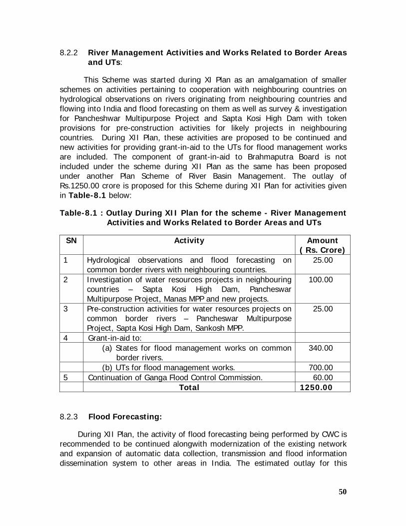
50
8.2.2 River Management Activities and Works Related to Border Areas and UTs:
This Scheme was started during XI Plan as an amalgamation of smaller schemes on activities pertaining to cooperation with neighbouring countries on hydrological observations on rivers originating from neighbouring countries and flowing into India and flood forecasting on them as well as survey & investigation for Pancheshwar Multipurpose Project and Sapta Kosi High Dam with token provisions for pre-construction activities for likely projects in neighbouring countries. During XII Plan, these activities are proposed to be continued and new activities for providing grant-in-aid to the UTs for flood management works are included. The component of grant-in-aid to Brahmaputra Board is not included under the scheme during XII Plan as the same has been proposed under another Plan Scheme of River Basin Management. The outlay of Rs.1250.00 crore is proposed for this Scheme during XII Plan for activities given in Table-8.1 below:
Table-8.1 : Outlay During XII Plan for the scheme - River Management Activities and Works Related to Border Areas and UTs
SN Activity Amount ( Rs. Crore)
1 Hydrological observations and flood forecasting on common border rivers with neighbouring countries.
25.00
2 Investigation of water resources projects in neighbouring countries – Sapta Kosi High Dam, Pancheswar Multipurpose Project, Manas MPP and new projects.
100.00
3 Pre-construction activities for water resources projects on common border rivers – Pancheswar Multipurpose Project, Sapta Kosi High Dam, Sankosh MPP.
25.00
4 Grant-in-aid to: (a) States for flood management works on common
border rivers. 340.00
(b) UTs for flood management works. 700.00 5 Continuation of Ganga Flood Control Commission. 60.00 Total 1250.00
8.2.3 Flood Forecasting:
During XII Plan, the activity of flood forecasting being performed by CWC is recommended to be continued alongwith modernization of the existing network and expansion of automatic data collection, transmission and flood information dissemination system to other areas in India. The estimated outlay for this

51
Scheme during XII Plan is Rs.425.00 crore to cover the broad activities given in Table-8.2.
Table-8.2: Outlay During XII Plan for the scheme - Flood Forecasting
SN Activity Amount ( Rs. Crore)
1 Spillover works of XI Plan 10.00 2 Installation of automatic data collection and
communication system to cover existing FF network (234 stations)
34.00
3 Extension of flood forecasting network in other areas (1000 stations)
223.00
4 Collection and dissemination of flood information to local authorities/ NDMA
158.00
Total 425.00
8.2.4 Farakka Barrage Project:
This Plan scheme is recommended to be continued in view of the importance of the activity of maintenance Farakka Barrage Project, its function in preservation and maintenance Kolkata Port Trust, importance of the project of Indo Bangladesh river water sharing arrangements. During XII Plan additional activities of decommissioning and commissioning of all gates and river training / bank protection works along rivers Ganag/Padma and Bhagirathi including afflux bunds and guide bunds are proposed to be carried out. The scheme is basically a transport sector scheme. For these activities an outlay of Rs.800 crore is proposed during XII Plan. Details are as under
SN Activity Amount ( Rs. Crore)
1 Anti-erosion works 300 2 Replacement of damaged gates of barrage 150 3 Other works of operation and maintenance of the Project 350 Total 800.00

52
8.3 Outlays under State Plan
Considering the information provided by the States as well as the information collected from the CWC, GFCC and Brahmaputra Board about flood management projects referred to them by the States, an outlay of Rs. 39100 crore is recommended to be provided by the Planning Commission to the States under their State Plan for undertaking the works related to flood management, anti-water logging, drainage congestion removal and coastal protection schemes.
It is also recommended that in addition to their prioritized plans for flood control measures/projects costing below Rs.100.00 crore, the State Governments should also undertake the following activities through their State Plans:
(i) Technology upgradation and preparation of flood hazard zonation maps.
(ii) Preparation of inundation maps and decision support systems.
(iii) Installation of computers, VSAT systems and other peripherals / equipment required for automatic receipt of online flood information.
(iv) Preparation of digital elevation models and inundation models for each basin.
(v) Other flood control / management measures in the States.
(vi) Maintenance of existing flood control structures including embankments.
8.4 The summary of the outlays recommended during XII Plan is as under:
SN Name of Programme / Scheme Outlay (Rs.crore)
A Central Plan (CP) I Central Sector (CS) (i) River Management activities and Works Related
to Border Areas and UTs 1250.00
(ii) Flood Forecasting 425.00 (iii) Farakka Barrage Project ( Transport Services) 800.00 Sub-total (CS) 2475.00 II State Sector (SS) (i) Flood Management Programme 16000.00 Sub-total ( SS) 16000.00 Total ( CP) 18475.00 B State Plan (SP) 39100.00 Grand Total ( CP+SP) 57575.00

53
Annexures

54
Annex-1.1 File No 25(1)/A/2010-WR
Government of India Planning Commission
(Water Resources Division)
436 Yogna Bhawan Parliament Street, New Delhi Dated 15.10.2010
ORDER
Subject: Constitution of Working Group on Flood Management and Region Specific Issues for the Twelfth Five Year Plan (2012-2017)
It has been decided to set up a Working Group on Flood Management and Region Specific Issues for the formulation of Twelfth Five Year Plan (2012-2017) with the following composition.
1. Prof. Nirmal Sengupta, IGIDR, Mumbai Chairperson
2. Member River Management , Central Water Commission, New Delhi (Co-Chairperson)
Co-Chairperson
3. Shri Dinesh Kumar Mishra, Barh Mukti Abhiyan , Patna, Bihar Member
4. Dr. Ravi Chopra, People's Science Institute, Dehradun Member
5. Shri Farhad Contractor, Founder Sambhav Trust, Rajasthan Member
6. Shri Sandeep Virmani, MD, Hunnarshala Foundation, Bhuj, Gujarat
Member
7. Shri Chandan Mahanta, IIT, Guwahati Member
8 Principal Secretary, Water Resources Department, Government of Uttarakhand, Dehradun
Member
9 Principal Secretary, Water Resources Department, Government of Kerala
Member
10 Principal Secretary, Water Resources Department, Government of Rajasthan , Jaipur
Member
11 Principal Secretary, Water Resources Department, Government of Bihar, Patna
Member
12 Principal Secretary, Irrigation, Assam, Dispur Member
13 Commissioner Ganga, Ministry of Water Resources, CGO Complex, New Delhi
Member-Secretary
2. The Terms of Reference to the Working Group will be
• Based on a critical review of the physical and financial performance of the flood management sector during the 11th Plan, suggest strategies, priorities and allocations for the 12th Plan
• Based on a review of the present strategy for the following regions , suggest a more effective way forward:
o Desert regions, o Coastal saline regions,

55
o Non –coastal saline regions, o Himalayas regions o Water logged areas
• Any other issue considered relevant by the Group. 3. The expenditure on TA/DA of official Members in connection with the meetings of the Working Group will be borne by the parent Department / Ministry/ Organization as per the rules of entitlement applicable to them. The expenditure in respect of non- official Members will be borne by the Planning Commission as per SR 190(a).
4. The Working Group will submit its report to Planning Commission by June 30th 2011.
5. Shri S.P. Kakran, Commissioner, Ganga, Ministry of Water Resources and the Member-Secretary of the Working Group will be the nodal officer for this Working Group and further correspondence /query may kindly be addressed to him.
Sd/-
( Avinash Mishra) Deputy Advisor (WR) Telefax: 011-23096732
To
1. Chairman and all Members of the Working Group. 2. PS to Deputy Chairman , Planning Commission 3. PS to all Members/Minister of State, Planning Commission. 4. PPS to Member Secretary, Planning Commission 5. Senior Advisor (Water Resources), Planning Commission 6. Advisor (Administration), Planning Commission 7. Advisor (Agri.), Planning Commission 8. Advisor (Plan Coordination and Management Division.), Planning Commission
Sd/-
( Avinash Mishra) Deputy Advisor (WR) Telefax: 011-23096732

56
Annex-1.2
File No 25(1)/A/2010-WR Government of India Planning Commission
(Water Resources Division)
436 Yogna Bhawan Parliament Street, New Delhi Dated 15.10.2010
ORDER
Subject: Constitution of Working Group on Flood Management and Region Specific Issues for the Twelfth Five Year Plan (2012-2017)
In continuation of Planning Commission's Order of even number dated
15.10.2010, it has been decided with the approval of the Competent Authority to include Joint Secretary, Disaster Management, Ministry of Home Affairs and a Joint Secretary Level Officer of the National Disaster Management Authority also as Members of the aforesaid Working Group.
Sd/-
( Avinash Mishra) Deputy Advisor (WR) Telefax: 011-23096732
To 1. Chairman and all Other Members of the Working Group. 2. Joint Secretary, Disaster Management, Ministry of Home Affairs,
North Block, New Delhi 110001. 3. Secretary, National Disaster Management Authority, NDMA Bhawan,
A-I, Safdarjang Enclave, and New Delhi 110029 with a request to nominate a Joint Secretary level Officer in the Working Group
4. PS to Deputy Chairman, Planning Commission 5. PS to all Members/Minister of State, Planning Commission 6. PPS to Member-Secretary, Planning Commission 7. Consultant (WR), Planning Commission 8. Adviser (WR), Planning Commission. 9. Adviser (Administration), Planning Commission. 10. Adviser (Agri.), Planning Commission 11. Adviser (Plan Coordination and Management Division) Planning Commission
Sd/-
( Avinash Mishra) Deputy Advisor (WR) Telefax: 011-23096732

57
Annex-1.3
Minutes of the First Meeting of the “Working Group on Flood Management and Region Specific Issues” for XII Five Year Plan (2012-17) held at Yojana Bhawan, New Delhi on 18th January, 2011.
1. The First Meeting of the Working Group on Flood Management and Region Specific Issues” for the XII Five Year Plan (2012-17) was held at Yojana Bhawan, New Delhi on 18th January, 2011. Prof. Nirmal Sengupta, IGIDR, Mumbai, chaired the meeting with Shri R.C. Jha, Member (River Management), Central Water Commission, New Delhi as Co-Chairperson of the Working Group. The list of participants is enclosed at Annexure-A. The representatives from the State Governments of Assam, Rajasthan, Uttaranchal and Kerala have not attended the meeting.
2. At the outset, Commissioner (Ganga) and Member-Secretary of the Working Group welcomed the Chairperson, Co-Chairperson and other distinguished Members of the Working Group.
3. Shri Avinash Mishra, Deputy Adviser (WR), Planning Commission gave a brief introduction on the constitution of the Working Group for the XII Five Year Plan and stated that the Working Group has been constituted with a view to provide a road map for flood management and regions specific issues for the XII Plan. He stated that under regional specific issues, some of the issues related to desert regions, coastal saline regions, non coastal saline regions, Himalayas and water logged areas, etc. may also be addressed by the Working Group.
4. Thereafter, Commissioner (Ganga) & Member-Secretary of the Working Group in his opening remarks gave a brief introduction of the flood situation in the country and stated that an area of over 45 million ha (m ha) is estimated as flood prone in the country as per the information furnished by the state governments; and in spite of various measures taken by the concerned States, one or the other parts of the country face flood fury almost every year. As a result, on an average Rs.1800 crore is lost annually as flood damage. He further informed that the XI Plan Working Group had proposed a total outlay of Rs.10,200 crore for State Plan and Rs.8500 crore as State Sector Scheme under Central Plan for Flood Management to benefit an area of about 2.18 million ha. Accordingly, a State Sector Scheme, namely, Flood Management Programme (FMP) was launched by the Ministry of Water Resources under Central Plan, in order to provide central assistance to the State Governments for river management, flood control, anti erosion works, anti-sea erosion works, drainage development, flood proofing, flood prone area development programme, etc. including restoration of damaged flood management works, in critical reaches. The scheme was approved at a total cost of Rs.8000 crore “in principle” by the Cabinet with a stipulation that all proposals related to the flood management works received from the State Governments would be examined by an Empowered Committee under the chairmanship of Secretary (Expenditure) in the Ministry of

58
Finance for cost effective solutions. He informed that a total of 353 flood control/river management works/schemes from 22 States have been approved under FMP till date and a central assistance of Rs.2353.60 crore has been released to the States so far; and a total of 149 schemes have been completed by the State Governments as on date. He further informed that on completion of the aforesaid 353 flood control/river management works/schemes, an area of 5.88 million ha. is proposed to be restored/protected against floods and it is expected to provide safety to over 57.55 million people during high flood situation. He further informed that a total protection against floods by structural measures alone is not possible and that optimum solutions lie in a combination of structural and non-structural measures. Central Water Commission (CWC) provides the flood forecasting and advance warning on flood prone inter state river basins in the country. India Meteorological Department (IMD) under Ministry of Earth Sciences takes meteorological observations to provide current and forecasts meteorological information for flood forecasting by CWC.
5. Chairperson stated that the protection of an estimated flood prone area of 45 m ha is a challenge in itself, and that there is a need to re-assess this figure. Chairperson stated that the work plan for achieving the targets set for the Working Group needs to be looked into considering that the report is to be submitted by 30th June, 2011. He further stated that at least, three meetings of the Working Group will be required to finalize the Report.
6. Principal Secretary, Bihar stated that Bihar is the most suffering state as regards flood is concerned and on the basis of experience of inclusion of schemes under Flood Management Programme (FMP) and release of funds thereafter, the procedure needs to be refined. He also expressed the need to re-assess the estimated flood prone area of 45 million ha. He stated that criteria of determination of the flood prone area needs to be redefined along with identification of flood prone blocks.
7. Member (RM), CWC and Co-Chairperson stated that the Working Group has to look into the overall national perspective of the country based upon the performance during previous X and XI Plans. There has to be fresh thinking for formulation of the future strategy on Flood Management. He agreed that the re-assessment of flood prone area can also be taken up by the Working Group. He stated that Ganga and Brahmaputra are facing specific issues with intensive erosion. He expressed the concern that the State Governments are mostly engaged in the raising and strengthening of the old embankments and anti erosion works; and very few new embankments and flood proofing schemes are being implemented by them.
8. Shri Dinesh Kumar Mishra, Barh Mukti Abhiyan, Bihar stated that the drainage aspects need to be looked into, as during the floods, breaches are reported inspite of the fact that maximum flood level was not attained. The flood water stayed for over two months as there was no drainage. He stated that the disaster is one time event, which is experienced without warning and needs to be re-defined, whereas the floods have become an annual event. He also stated that the flood prone area of Bihar needs to be re-assessed. He also stated that development activities are destroying the drainage pattern and thereby, prevent water from flowing out. He requested the Disaster Management Department in the State Governments to be merged with the State Government Water Resources Department.

59
9. Dr. Ravi Chopra, People’s Science Institute, Dehradun stated that response to floods is an important aspect in addition to the controlling floods. He also mentioned about the recent Alaknanda floods in Uttaranchal, wherein the Upper Ganga Canal got choked due to silting and was closed for a long period of time. He also made mention of past floods wherein the natural obstructions, formed due to silt deposition, got burst and caused floods. He mentioned that inspite of existence of Tehri Dam, there was disaster in 2010, with Haridwar city in water for 15 days. He requested to adopt a broader perspective for flood management. He further stated that the change in climate pattern will increase the frequency of excess rains and increase the frequency of floods. He stated that some studies have been done to develop the co-relation between very high intensity rainfall and the nature of the watershed. He stated that there was deforestation during 19th and 20th century in the river valley of Bhagirathi and Sutlej. He further stated that although a lot of afforestation plans have been implemented, but nothing much could be achieved as the involvement of local community is essential for the success of afforestation activities. He further added that there has to be combination of forests, people and water to achieve the success in this regard. People should realize that they are owner of the water resources. He stated that the response of the Disaster Management Authorities has been very slow in the recent floods.
10. Shri Farhad Contractor, Founder Sambhav Trust, Rajasthan stated that the State of Rajasthan is drought prone state. However, during the year 2006, in the Barmer area, there was flood as natural drainage blocked at so many places, causing a cascading effect. However, this year although there was more rainfall but it caused no flooding. He stressed the need of community’s involvement in various activities.
11. Joint Secretary, NDMA, stated that the National Disaster Management Authority had come up with the guidelines on the management of the floods in January-2008. He stated that in order to formulate a future strategy, the information on the present strategy is very much required. He requested that CWC, the nodal Department on flood management may bring out present strategy and the issues which need to improve upon. He stated that the emphasis of NDMA is on flood forecasting and regulation of reservoirs. He further enquired about the possibility to improve the flood forecasting techniques to reduce the forecasting time and the cost involvement thereof, so that a decision can be taken in this regard. He suggested to adopt river basin approach. For Flood Forecasting, the data related to neighbouring countries can be made available by NRSA and, therefore, he suggested to co-opt one Member from NRSA in the Working Group. He stated that the CWC is aware regarding the flood plain zoning and vulnerability of different areas as regards to floods. He pointed out that contour maps of flood prone areas are critical requirements and the State Governments should be sensitized to develop and modernize activities related to the flood management.
12. DDGM, IMD stated that IMD provides meteorological data to CWC for flood forecasting. He stated that there is public awareness regarding cyclone warning but in case of floods, the same needs to be improved.
13. Co-Chairperson stated that there are philosophical and implementation aspects related to development. He stated that the inhabitation in the flood plains is causing the blockage of natural drainage and the inhabitants in flood plains suffer

60
due to floods in spite of jacketing of rivers. He also mentioned about the need to implement catchment area treatment plans with involvement of the local people.
14. Chairperson praised CWC for their performance in flood forecasting. Member (RM) stated that CWC issues flood forecasts with more than 95% accuracy. Shri Sanjay Agarwal, Director, Disaster Management Cell, Ministry of Home Affairs stated that Ministry of Home Affairs is the nodal Ministry for natural and manmade disaster. He further added that MHA is also formulating a Flood Risk Mitigation Project and expressed concern over any duplication with the schemes being operated by MoWR. Member (RM) stated that there is no duplication of such activities of MHA & MOWR at present. MHA may take necessary steps to see that there is no duplication in future.
15. Shri Chandan Mahanta, IIT, Guwhati also expressed the need to co-opt a member from NRSA. He stressed the need to develop the flood vulnerability index maps. He stated that the present system of embankments has not delivered the desired results and suggested to the re-designing of embankments. He suggested that a system of scientifically designed raised platforms; community housing with live stock units, health units where the people can be accommodated during the four months of floods may be adopted to deal with floods. Thereafter, the same infrastructure can be used as community centres. He stated that such facilities should be created to provide dignity to the female members during disasters.
16. Principal Secretary, Bihar expressed concern over the availability and accessibility of precise flood data. He also expressed concern over the inadequate gauge stations and requested CWC to look into it.
17. Chairman, GFCC stated that there should be bare minimum expenditure on anti- erosion schemes and more emphasis may be laid on drainage schemes in future. Shri Chandan Mahanta, Professor, IIT, Guwahati stated that Stage Discharge Inudation curves can help to minimize losses.
18. Shri Avinash Misrha, Deputy Adviser, Planning Commission stated that with the construction of the embankments, the rivers have been jacketed and as a result, the river beds are going up. He suggested to develop appropriate methodology for de-silting of the rivers in future.
19. Chairperson stated that critical review of the XI Plan needs to be undertaken by the Working Group. He stated that embankments are short term measures which started from IX Plan, is having little impact and it requires rethinking in planning. A more systematic approach may be adopted now, instead of living with floods. The mitigation aspects also need to be incorporated in the current strategy and allocations made accordingly.
20. Co-Chairperson requested all the Members of the Group to go through XI Plan Working Group Report to have a better understanding of the present scenario and strategies. Deputy Adviser, Planning Commission informed that the Reports of XI Plan Working Group and Mid-term Appraisal of XI Plan schemes of flood control sector are available on Planning Commission’s website (http://planningcommission.gov.in/).

61
21. Member-Secretary clarified that the drainage development works are already covered under Flood Management Programme (FMP) of the Ministry of Water Resources. He stated that under Flood Management, there are two types of actions involved, one linked to the structural engineering and another to the non-engineering solutions. The implementation of structural measures rests with the State Governments. He further stated that an area of 18 million ha has been provided with reasonable degree to protection up to X Plan. The State Governments have to formulate the new schemes to cover the remaining flood prone areas and improve upon the infrastructure available in the States to achieve the new targets. He stated that due to slow implementation of the on-going schemes under FMP particularly, in the States of Assam, Arunachal Pradesh, Sikkim and Jammu and Kashmir, Orissa, etc. the release of funds is quite low and the present level of expenditure of Rs.2350 crore as on date indicate that the outlays of Rs.2715 crore provided by Planning Commission for XI Plan is not yet utilized by the States. He stressed the fact that Flood Management is a State subject and the central organizations, namely, Ganga Flood Control Commission, Brahmaputra Board and Central Water Commission are there to providing technical support to the State Governments for implementation of the schemes under FMP. The State Governments need to enhance their infrastructure and resources to take up the huge task ahead. He was disappointed to note that out of five Principal Secretaries of State Governments invited for the Working Group’s meeting, only Principal Secretary from Bihar has come to attend the meeting and representatives from other State Governments of Assam, Rajasthan, Uttaranchal and Kerala have not cared to attend the meeting. It shows that many State Governments are not serious about the flood management works in their States and do not send the requisite information about flood management works to this Ministry in time.
22. Co-Chairperson stated that only 32 m ha area, out of total flood prone area of 45 m ha can be protected by different flood management measures. Member (RM) stressed the need for a basin wise integrated planning to tackle the problem of floods. He stated that the construction of Narmada and Sardar Sarovar dams have controlled the flood problems in Narmada Basin to a large extent. He also mentioned about Srisailam and Nagarjuna Sagar dams, where the spillway gates could not be opened in time, inspite of the 24 hrs advance warnings was given by CWC, leading to flooding in the upstream area.
23 Thereafter, Shri Chandan Mishra, IIT, Guwahati requested that agenda items proposed by Member-Secretary may be discussed. However, the discussions were continued unstructured.
24. Shri Dinesh Kumar Mishra, Barh Mukti Abhiyan, Bihar wanted that models for breached forecasting are developed. Chairman, GFCC stated that it may not be possible to predict a breach. Shri Mishra stated that flood plain zoning cannot be done in Uttar Pradesh, Bihar and Assam. Co-Chairperson stated that in addition to natural breaches there are manmade breaches also. He has advised the State Government of Bihar to introduce sluices to take care of needs of the farmers and to avoid man made breaches.

62
25. Chairperson stated that CWC will be able to provide relevant data to the Working Group for evaluating the performance of the Flood Management Measures during XI Plan.
26. Dr. Ravi Chopra, People Science Group suggested that at least four additional sessions may be required for finalization of the Working Group Report. During the first session, critical review of XI Plan and its performance can be taken up, during the 2nd session, the proposals related to national issues can be discussed and thereafter, regional issues can be addressed in the next meeting and draft report be finalized in the 4th session. He stated that he would like to make a presentation on flood routing problems, breaches, etc. in the next meeting.
27. Shri Farhad Contractor, Founder of Sambhav Trust, Rajasthan stated that the Vulnerability Atlas of India prepared in 1978 already exists and needs to be revised.
28. Shri Chandan Mahanta, from IIT, Guwahati stated that as per the proposed Agenda No.2, the provision of adequate flood cushion should be enforced in dams and reservoirs for long term solution of flood problems. Co-Chairperson stated that for the various schemes formulated in Arunachal Pradesh, a lot of efforts have been made for incorporation of flood cushion in dams and reservoirs. But with the limited land area available in Arunachal Pradesh, the State Government of Arunachal Pradesh is reluctant to incorporate the flood cushion in such schemes.
29. Joint Secretary, NDMA enquired whether it is possible to digitize the contour maps for the entire country. Member-Secretary stated that Survey of India may be able to provide the contour maps in the range of 20 to 25 cm on chargeable cost basis.
30. After deliberations, it was decided that the 2nd meeting of the Working Group will be held in the 3rd week of February, 2011 and 3rd meeting in first week of April, 2011 at New Delhi. The Working Group further decided that:
(i) The 2nd meeting of Working Group will be held on 17th February, 2011 at New Delhi, to discuss the agenda of “Review of performance of XI Plan flood management measures”.
(ii) As CWC is required to advise MOWR and also look after the policy issues and other aspects of Flood Management in the whole country, Member (RM), CWC and Co-Chairperson of the Working Group has nominated Director (FMP), CWC as Nodal Officer for the Working Group for collection/compilation of various details from the State Governments and provide assistance in compilation of the Working Group’s Report. Accordingly, it was decided that Director (FMP), CWC will collect and compile the information/ data required for the finalization of the Working Group Report for XII Plan as per the enclosed Annexure Sl.No. 1 to 4 which may suitably be revised and further Annexure(s), if any, may be added by CWC as per requirements.
(iii) CWC will provide an overview of the present scenario on Flood Management in Second Meeting of the Working Group and suggest new

63
strategies in the third meeting for Flood Management in the country during XII Plan.
(iv) A representative from NRSA may be co-opted as Special Invitee in the Working Group.
(v) The figures of estimated flood prone areas of 45 m ha would be re-assessed by CWC and submitted to the Working Group in the third meeting.
****
List of participants in the First meeting of XII Plan Working Group on “Flood
Management and Region Specific Issues” held in Yogna Bhawan, New Delhi on 18.01. 2011
Sl. No
Name
1 Prof. Nirmal Sengupta, IGIDR, Mumbai Chairperson 2 Shri R. C. Jha, Member (RM), Central Water Commission, New
Delhi. Co-Chairperson
3 Dr.Ravi Chopra, Director, People’s Science Institute, Dehradun
Member
4. Shri Dinesh Kumar Mishra, Convenor, Barah Mukhti Abhiyan, Bihar.
Member
5
Shri Chandan Mahanta, Professor , IIT , Guwahati Member
6 Shri Ajay Nayak, Principle Secretary (WR), Govt, of Bihar, Patna
Member
7 Shri Farad Contractor, Founder Sambhav Trust, Rajasthan Member 8 Shri P. K. Tripathi, Joint Secretary, NDMA, MHA Member 9 Shri Sanjay Agrawal, Director, (DM), MHA Member 10 Shri S.P. Kakran, Member (D&R), Central Water
Commissioner, New Delhi.Member-Secretary
11 Shri A.K. Ganju, Chairman, GFCC, Patna Special Invitee 12 Shri Avinash Mishra, Dy. Advisor (WR), Planning
Commission, New Delhi Special Invitee
13 Shri N.Y. Apte, DDGM, IMD, New Delhi Special Invitee14 Shri L.K. Taneja,
Sr. Joint Commissioner (Ganga), MoWR Special Invitee
15 Shri C.Lal, Director (FMP), CWC, New Delhi
Nodal Officer
16 Shri M.S.Varma, Dy. Commissioner Ganga), MoWR
Special Invitee

64
Annex-1.4
Minutes of the Second Meeting of the “Working Group on Flood Management and Region Specific Issues” for XII Five Year Plan (2012-17) held at Central Water Commission, Sewa Bhavan, R.K. Puram, New Delhi, on 17th February, 2011.
1. The Second Meeting of the Working Group on Flood Management and Region Specific Issues” for the XII Five Year Plan (2012-17) was held at Central Water Commission, Sewa Bhavan, R.K. Puram, New Delhi, on 17th February, 2011. Prof. Nirmal Sengupta, IGIDR, Mumbai, chaired the meeting with Shri R.C. Jha, Member (River Management), Central Water Commission, New Delhi as Co-Chairperson of the Working Group. The list of participants is enclosed at Annexure-I.
2. At the outset, Commissioner (Ganga) – in charge, and Member-Secretary of the Working Group welcomed the Chairperson, Co-Chairperson and other distinguished Members of the Working Group. Member-Secretary of the Working Group in his opening remarks gave an overview of the first meeting of the Working Group held on 18th January, 2011 at Planning Commission, New Delhi, and recalled the issues which were discussed in the first meeting of the Group. He stated that the minutes of the meeting were circulated to all the members of the Working Group, and, as decided therein the performance of XI Plan Flood Management measures would be reviewed in this meeting besides discussing the strategies, priorities and region specific issues for the Twelfth Five Year Plan.
3. Chairperson of the Working Group initiated the meeting by requesting CWC to give an overview of the Flood Management during XI Plan along with strategies for XII Plan.
4. Co-chairperson of the Working Group requested Director (FMP), CWC to give an overview of Flood Management in India. Director (FMP) in his presentation outlined different aspects related to floods in the country; viz. the causes, damages, different river basins and flood problems therein etc. The presentation included flood management strategies adopted so far, roles of different Organizations/Departments, the strategies adopted by XI Plan Working Group to deal with floods and proposed thrust areas for XII Plan period, which include scientific assessment of flood prone areas, maintenance of embankments, sediment management, integrated reservoir regulation, basin-wise approach for flood management, extension of flood forecasting network of CWC to important reservoirs and cities located on rivers banks.
5. Director (FMP) further stated that as far assessment of flood prone areas is concerned, a scientific criteria needs to be adopted based on frequency of flooding and period of inundation based on appropriate contour maps and satellite imagery data. CWC proposed that the flood prone areas may be classified as severe, moderate, low and occasional flood prone areas, as follows:
(i) Severe flood prone areas: Average area affected in two years >= 50% of total area and inundation >= 4 days;

65
(ii) Moderate flood prone areas : Average area affected in five years >= 25% of total area and inundation >= 4 days;
(iii) Low flood prone areas - Average areas affected in five years is between 15% to 25 % of total area and inundation >= 4 days;
(iv) Occasional flood prone areas - Average areas affected in ten years is 15% of total area or less and inundation >= 4 days.
6. Co-Chairperson stated that the construction of embankment is one of the effective methodologies still being adopted for flood management. The use of embankments as flood management measure is very old and effective practice, although it may have deficiencies, which need to be reviewed. He further stated that the breaching of embankments is a very critical problem due to its unpredictability in the dimension of time and location. He expressed concern over the fact that in spite of various measures taken by Central and State Governments there has not been much significant addition to the flood protected area in the last ten years.
7. Chairman, Brahmaputra Board observed that participation from North-Eastern States in the Working Group is not satisfactory and needs to be improved. He stated that North Eastern States are severely flood affected States and Flood Management Programme (FMP) is an important programme in respect of North Eastern Regions and during XI Plan under FMP, Central assistance amounting to Rs.570 crores has been released so far to North-Eastern States against total approved central assistance of Rs.1153 crores for XI Plan. He informed during the current financial year, barring Assam, all other North Eastern States have submitted the proposals for release of central assistance to Brahmaputra Board. He stressed on the need of specific provisions/strategies for flood management in the NE region in view of the peculiar problems faced by the region. He informed the need of following river basin approach for flood management and talked about eight river basin organizations for integrated water management planning. He informed the Working Group about Standing Committee of Experts under the Chairmanship of Member (RM), CWC to look after the technical aspects related to implementation of two important projects in Majuli Islands and Hathigulli.
8. Co-Chairperson of the Working Group stated that a lot of time is lost in completing the formalities affecting the real work to be executed during the short working period available.
9. Chairman (GFCC) stated that flood management measures in the jurisdiction of GFCC are mostly anti-erosion works, and the progress of these works get hampered due to procedure for getting approvals at different levels. The procedural delay affect the execution of works during working period which consists of non-monsoon period only. In view of the above, he suggested, the process of funding/approval can be cut short so that sufficient time is available with agencies for executing the works in the field. He further suggested that only those schemes which are very critical in long term should be considered for funding by Central Government and other schemes/works may be taken up by concerned State Governments only. Adding to this, Chairman of the Working Group emphasized that procedures constitute an important part in the entire process and efforts should be made to minimize the time

66
line for procedures. He also emphasized the need to consider price index while quoting the financial provision in respect of flood management.
10. Engineer-in-Chief (Irrigation), Government of Bihar stated that the figures of flood prone areas assessed by RBA and State Government of Bihar are different and therefore needs to be re-assessed, so that there is mutual concurrence on related issues of flood management amongst concerned agencies/departments. He, thereafter, referred to the physical and financial progress made by the State Government of Bihar in the flood control sector during the XI Plan. He emphasized that since there is no scope for construction of reservoirs in States like Bihar, the only solution lies in the raising and strengthening of the embankments to maintain the benefits, to create additional Levies, channelization, etc. He informed that for the dredging works in Kosi and Gandak rivers tenders have been invited. He also suggested that the flood plain zoning is not a very viable option due to high population density in the State and should be done with great caution, wherever required. He also requested to increase numbers of gauge and discharge stations by CWC as State Government is not in a position to finalize South Bihar schemes.
11. Co-chairperson of the Working Group stated that during the last two Five Years Plans there has been no additional protection of areas in Bihar and added that wherever the existing embankments are having deficiencies, these should be strengthened and attended to.
12. Shri Dinesh Kumar Mishra, Barh Mukti Abhiyan, Bihar pointed out the different figures of flood prone areas related to Bihar in the various reports to which, Co-Chairman responded by stating that the difference in figures may be due to revision in Plan documents of the State Government. Shri Mishra stated that the flood plain zoning is not possible in Bihar as the development work will get affected. Shri Mishra further added that inefficient functioning of sluice gates is mainly responsible for failure of embankments and subsequent flooding. He further suggested that sluice gates in embankments should be surveyed and maintained on regular basis.
13. Chairperson (Working Group) added that as far assessment of flood prone area in concerned; different criteria are adopted by different agencies based on different methodologies and consequently the difference in figures. He added that even if this incongruity over the assessment of flood prone area may take some more time to straighten, specific recommendations as to the size and strategies for XII Plan needs to be finalized by the Group, considering the quantum of works which needs to be done in the field of flood management in the coming years. He also suggested that the term “flood prone areas” should be replaced by “areas vulnerable to floods”.
14. Shri Mishra further suggested the need to examine whether raising and strengthening of existing embankments is proving to be effective in serving the desired purpose or a re-thinking is required in this area. Shri Mishra highlighted the problems relating to sedimentation, rising of beds and breaches in case of embankments. He further added that the negotiations with Nepal are not yielding any significant results; in such a case, river basin planning approach may not work. He expressed his reservations on adopting river basin planning approach while formulating any decision/ policies regarding flood management, particularly in the Ganga and Brahmaputra basins, as these basins are not falling entirely in the country

67
and are shared with neighboring countries. He was also critical of dredging stating that the excavated material are not properly disposed off .He was also critical of the re-habilitation policy related to Mahanadi and Bagmati schemes wherein the related issues have not been addressed suitably. He stated that the rehabilitation policy should have an element to ensure that sources of livelihood of people may not be curtailed.
15 Mr. Bhanumurthy of National Remote Sensing Centre (NRSC) informed the Group that NRSC under ISRO Disaster Management Support Programme (DMSP) is involved in generation of aerospace information/ products for Natural Disasters viz; floods, Cyclone, Agricultural draught, landslides etc. Beside this, support services are also being provided for specific events such as breaches in embankments etc. at the request of State Govt/ Ministry of Home Affairs. He informed the Group that following activities are executed under ISRO’s DMS Programme.
i. Flood Hazard Zonation: Hazard information is one of the pre-requisite for non-structural flood management. Using flood inundation information derived from satellite data sets for historic flood events occurred during 1998-2007 flood hazard maps for Assam State have been prepared. Based on the extent of area in each hazard zone and the severity a hazard index was developed for classification of hazard prone districts in Assam State. A flood hazard zone atlas is prepared for Assam State and it was reviewed by a committee constituted by NDMA with representatives from CWC, IMD, NDMA, Govt. of Assam and NRSC/ISRO. A web enabled application also being developed for visualization of the atlas. Similar flood hazard maps with respect to Bihar and Orissa are under preparation.
ii. Close Contour Information: It is one of the most vital information in flood management NRSC/ISRO has built capability for acquisition of very high resolution data using Digital Camera (DC) and also high resolution elevation data using Airborne Laser Terrain Mapper (ALTM) from aerial platform. ALTM data acquired for chronic flood prone areas in Orissa, Bihar, Assam, Andhra Pradesh and Coastal areas, is being processed. Since the data acquisition & processing is quite complex, a systematic acquisition is being done in a phased manner.
iii. River Configuration & Bank Erosion Studies: For planning mitigation measures, river configuration and its behavior is important. Using multi-temporal satellite data sets changes in the river configuration, bank line changes, existing flood control works were mapped for selected reaches of Ganga, Kosi, Gandak and Brahmaputra at the request State/Central Government departments. The information is used for identification of vulnerable pockets and planning necessary strengthening measures.
iv. Flood Forecasting: In association with CWC, flood forecasting using space based inputs has been initiated on pilot scale in the selected reaches of Godavari river. Based on the forecasted flood level, spatial inundation simulation is being attempted using close contour information for better flood warning.
v. Development of Geo-Spatial Tools: Spatial database is the primary requirement for planning flood mitigation measures. NRSC aims at building a comprehensive geo-spatial database of the disaster vulnerable regions of the country. For about 60 flood and cyclone prone districts, digital database on 1:50,000 scale was
68
developed. Web based applications have been developed in GIS environment for identification of suitable sites for flood shelters.
vi. Flood Mapping & Damage Assessment: For major flood events occurred in the country flood inundation information was derived from satellite data and it was made available in near real-time to the concerned State and Central Government department. The flood inundation information is integrated with the digital database for estimation of district-wise extent of flood inundation, marooned villages, crop area submerged and the transportation network in the affected area. This information is primarily used in the relief management by the State Governments.
vii. A VSAT based satellite communication network has been put in place for online transfer of space enabled inputs to the concerned State and central Govt. user departments. Regular training programmes on annual basis are being organized exclusively for State government officials for enabling them for better utilization of space derived products for disaster management.
16. Mr. Sanjiv Nair (Mission Director), Mission on Geo-spatial Applications, Deptt. of Science & Technology, briefed the Working group on the on-going flood modeling programme under the Mission. The Mission is doing flood modeling for the Tapi river and the Mahanadi. During the last two years on both rivers the Mission has been able to quantify accurately the water discharge as a consequence of the rainfall in the catchment region of the respective rivers. In all these flood estimation models the forecast on inundation was poor because of the coarse digital elevation model data sets. In the current 50,000 scale maps available with the Survey of India, these have little value for inundation forecasting because of the inaccuracies between 10m to 20m. The Mission therefore is drawing in house finer DEMs using ground control points and stereo satellite data for both the river regions.
17. It was observed by the Mission Director that the data base for either controlling flooding or taking preventive measures, the quality of digital elevation models is of prime requirement, without which accurate work on planning and seeing the effectiveness of flood prevention works would be minimal. Therefore, he suggested that finer DEMs along the major river systems including the area falling in the flood affected zone should be mapped by DEMs of no more than 0.5m to 1m. He further informed that the Mission has been working on making terrain models which could then be easily used for planning of all flood prevention works, and, if this is combined with the capability to do run-off studies as well as flood forecasting studies, a fairly good assessment of the effectiveness of prevention works could be done. Regarding quality of data with the Irrigation departments of the respective states, it was mentioned that the Mission has a very strong component of research and development in communications. As an extension, water level sensors with the capability to draw data in real time have been developed. Mr. Nair suggested that working group should consider better water level gauging systems, along with the capability to provide the communications arrangements so that data can be available without human error. This could be done at critical junctures initially and then expanded as part of the network during the 12th plan. It was also suggested by him that flood inundation data for different river systems for the past 10 years may be made available for use by different organizations.

69
18. Mr. Tripathi from NDMA stated that with 10 years data available with NRSA for some of the rivers/basins, further efforts should be made to have a data bank of all basins. The State Governments may be encouraged to own the data, and using the modern technology, the data may be fully digitized and put into application by the State Governments. State Governments should strengthen themselves and should have capacity for undertaking such activities for tackling flood problems.
19. Mr. Ravi Chopra of People Science Institute, Dehradun stated that flood management measures are quoted in terms of the financial expenditure. He desired that the outcome of such flood management measures should be assessed in terms of their effectiveness in changing the extent/proneness of the flood prone area; i.e. severe flood prone area to moderate flood prone area etc. He was in favour of adopting a regional specific approach. He stated that specific activities need to be taken for broad approach and filling in the space for activities, schemes and allocation based on what has worked in the past. He mentioned about the role of Forests Department for watershed management for erodibility/highly damaged protection/flash flood/erosion. He stated that integrated watershed management plays a critical role in flood control.
20. Co-chairperson of the Working Group stated that CWC is presently operating 1000 sites and there is a plan to triple them in XII Plan. River cross section at 10 Km. intervals of major rivers by CWC officials/contractual arrangements are being obtained. He further stated that the hilly areas like Arunachal Pradesh, Himachal Pradesh are affected by erosion and measures for protecting areas against erosion need to be taken. The concept of embankments also needs to be re-looked. He cited the case of Mahanadi and Narmada basins wherein on following the river basins concept, no floods/drought is being experienced. The modern practices adopted with the help of the neighboring countries and river basin planning need be pursued.
21. Prof. Mahanta of IIT, Guwahati stressed that the review of flood management work done so far is very important to plan for future. The future strategies for flood management should be based on a critical review and analysis of the policies/measures adopted during the earlier plan periods. He further stressed that in North-Eastern Region of the country, bank erosion is as critical issue as floods, and in some part bank erosion and landslides are the most critical issues faced by the local people, and therefore, these issues needs to be given special attention by the Group. He also emphasized that sustainability and workability in long term should be two key factors while prioritizing and identifying clear cut strategies and expected results for flood management. He added that there should be long-term and comprehensive planning for flood management instead of short-term measures.
22. Chairperson, Working Group, enquired about the availability of the information from the State Governments, to which Director (FMP) CWC responded that the State Governments are being perused to obtain the information required by Working Group.
23. Chairperson, Working Group pointed out that role of watershed in flood control is a relatively new but very effective and, therefore, it should be included in flood management. He stressed on the need of regular maintenance of the embankments and appropriate use of embankments and cited the example of Cyclone shelters, which are mostly used during Cyclones and remain unoccupied and remain un-

70
encroached, otherwise. Chairperson stated that flood prone areas estimate and zoning is very important and needs to be considered along with the provision of shelters for floods.
24. Outgoing Member-Secretary of the Working Group and Member (D&R), CWC expressed satisfaction over the focused discussion by the group members on the relevant issues. He suggested that the Group may finalize the strategies for flood management for the XII Plan and make categorical recommendations to Planning Commission on the issues, viz., criteria for assessment of flood prone area, type of works to be taken up during XII Plan for Flood Management, size of Plan etc. He also emphasized on the need to adopt an approach for flood management which takes care of relevant issues in the coastal and hilly regions also. He informed under the R&D Scheme of MoWR under Commissioner (PP), funds are available for R&D activities to be carried out under Central Plan. He stated that the Flood Shelters etc. fall in the domain of the Ministry of Home Affairs.
25. During the discussions, the following decisions /suggestions came out:
(i) The information/data from the concerned State Governments would be collected by Director (FMP), CWC and Nodal Officer of the Group, who agreed to pursue the matter with State Governments and Union Territories to provide the same to the Working Group, in its third meeting.
(ii) A presentation would be made by Dr. Ravi Chopra of People’s Science Institute, Dehradn, who may supply a copy of the presentation in advance to Chairperson and Co-Chairperson of the Working Group before the third meeting of Working Group.
(iii) The third meeting of the Working Group will be held on 5th April, 2011 in New Delhi with agenda to discuss regional specific issues strategy for tackling the problems of drought in desert regions, coastal erosion in coastal saline regions, flash floods in Himalayan region, reclamation of land in water logged areas besides the problems related to non-coastal saline regions and suggest an effective way forward.
(iv) Thrust areas for XII Plan may include the following among others:
a. Scientific assessment of flood prone areas. Criteria for assessment of Flood Prone area, as suggested by CWC may be recommended by the Working Group.
b. Regular maintenance and periodical inspections of existing Embankments and use of state of the art materials.
c. Integrated reservoir regulation.
d. Extension of flood forecasting network of CWC to important reservoirs and cities located near rivers.
e. Basin wise flood management approach.
(v) In view of the suggestions to avoid the procedural delays in the disbursement of the funds to the State Governments; only those

71
schemes which are very critical in long term should be considered for funding by Central Government and other schemes/works may be taken up by concerned State Governments through their Annual Plan allocations in State plan, as these schemes have already been techno-economically appraised by CWC/GFCC.
As such the Flood Management being a State subject, the schemes for flood control planned, funded and executed by the State Governments, as per their own priorities, out of State plan funds which are made available to them through Planning Commission. The Central Government renders assistance, which are technical, catalytical and promotional in nature. Further the suggestion is in conformity with the allocated function of MoWR i.e to provide special central financial assistance for specific projects.
Planning Commission may consider allocating the major portion of the Plan outlay earmarked for Flood management directly to State Governments as per their requirements under State’s Annual Plans under Flood Management Sector and make balance allocation for providing special central financial assistance to specific critical flood management works only, under State Sector Scheme “Flood Management Programme”.
(vi) As Central Water Commission is mandated to carry out the techno-economic appraisal of Flood management schemes and would be in a better position to judge the criticality of the specific schemes to be provided special central financial assistance; to avoid the procedural delays, and recommend only specific critical schemes which cannot be funded by State Government’s from their respective Annual Plans, a “Technical Empowered Committee” under the Chairmanship of Chairman, CWC and representatives from Brahmaputra Board, Ganga Flood Control Commission, Ministry of Water Resources, Ministry of Finance, Planning Commission, Ministry of DONER and with Chief Engineer (FM), CWC as Member Secretary may be proposed .
(vii) The role of watershed may be included in flood management.
(viii) It was decided that the Members may give their suggestions/views for inclusion as strategies to be adopted for XII Plan to Director (FMP) at his E-mail address [email protected]. All suggestions/feedback/inputs for “Working Group on Flood Management and Region Specific Issues” for XII Five Year Plan (2012-17) may also be sent at the above E-mail address.
(ix) Ministry of Home Affairs may include the provision of flood shelters under the National Flood Risk Mitigation Project, or any other Plan.
(x) NRSC may expand the already operating Plan Scheme “Disaster Management Support Programme” to include more rivers/basins and which may also include strengthening of State Government’s capabilities on data acquisition and its digitization, maintenance and applications using modern techniques for

72
the flood management. NDMA may provide necessary support to NRSC in this regard.
26. The meeting ended with the Vote of Thanks to the Chair.
****

73
Annexure-I
List of participants in the Second meeting of XII Plan Working Group on “Flood Management and Region Specific Issues” held on 17.02.2011 in
Central Water Commission, Sewa Bhavan, R.K. Puram, New Delhi.
Sl. No
Name Contact Details
1 Prof. Nirmal Sengupta, IGIDR, Mumbai
Chairperson Mob. 9869954604 Email: [email protected] Email: [email protected]
2 Shri R. C. Jha, Member (RM), Central Water Commission, New Delhi.
Co-Chairperson
Tel. 011-26103221 E-mail: [email protected]
3 Shri Ravi Chopra, Director, People’s Science Institute, Dehradun
Member Tel. 0135-2763649, 2773849, Mob. 09411135976 E-mail:[email protected]
4. Shri Dinesh Kumar Mishra, Convenor, Barah Mukhti Abhiyan, Bihar.
Member Tel.- 0657-6574059 Mob.9431303360 E-mail: [email protected]
5 Shri Devi Rajak (Engineer-in-Chief), Govt. of Bihar, Patna.
Member 0612-2217183 Mob. 9931877570
6. Shri Chandan Mahanta, Professor, IIT Guwahati, Guwahati 781039.
Member Mob.: 094351-19090 E-mail: [email protected]
7. Shri Padma Kant Jha, Resident Engineer, Liaison Office, W.R. Department, Govt. of Bihar, New Delhi
Member Mob. No.9868631245 Telefax: 011-26850296 E-mail: [email protected]
8 Shri P.K. Tripathi. Adviser & JS, NDMA, New Delhi
Member Mob. 9868871124 E-mail:[email protected]
9 Shri Sanjay Agarwal, Director (DM), MHA, New Delhi
Member Tel. - 011-24642381 E-mail: [email protected]
10. Shri G. Aranganathan, Commissioner (Ganga) (In-charge)
Member -Secretary
Tel. 011-24361540 E-mail: [email protected]
11. Shri S.P. Kakran, Member (D&R), Central Water Commissioner, New Delhi.
Special Invitee
Tel. 011-26108150 E-mail: [email protected]
12. Shri Sanjiv Nair, Mission Special Tel. 011-26531299

74
Sl. No
Name Contact Details
Director, Mission on Geo-Spatial Applications, Department of Science & Technology, New Delhi.
Invitee Mob. 9891115151
13. Shri A.K. Ganju, Chairman, GFCC, Patna
Special Invitee
Mob. 9810049425 E-mail: [email protected]
14. Shri Awadhesh Sharma, Director, GFCC, Patna
Special Invitee
15. Shri Shankar Mahto, Chairman, Brahmaputra Board, Guwahati
Special Invitee
Tel. : 0361-230199 , 2301309 E-mail: [email protected],
16. Shri V.Bhanumurthy, Project Director, NDEM, NRSC/ISRO, Hyderabad 500625
Special Invitee
Tel.- 040-23884252 E-mail: [email protected]
17 Shri C.Lal, Director (FMP), CWC, New Delhi
Special Invitee
Tel. 011-26168258,M:9811054157 E-mail: [email protected]
18 Shri L.K. Taneja, Sr. Joint Commissioner (Ganga), MoWR
Special Invitee
Tel.: 011-24360611 E-mail: [email protected]
19 Shri M.S.Varma, Dy. Comissioner(Ganga), MoWR
Special Invitee
Tel: 011-24361565 E-mail: [email protected]

75
Annex-1.5
Minutes of the Third Meeting of the “Working Group on Flood Management and Region Specific Issues” for XII Five Year Plan (2012-17) held at New Delhi on 5th April, 2011.
The Third Meeting of the Working Group on Flood Management and Region Specific Issues” for the XII Five Year Plan (2012-17) was held at Sewa Bhavan, R.K. Puram, New Delhi, on 5th April, 2011. Dr. Nirmal Sengupta, IGIDR, Mumbai, chaired the meeting with Shri R.C. Jha, Member (River Management), Central Water Commission, New Delhi as Co-Chairperson of the Working Group. The list of participants is enclosed at Annexure-I. 2.
2. At the outset, Chairperson welcomed Co-chairperson & members of the Working Group (WG) and thereafter introduced Shri. Devendra Sharma, Commissioner (Ganga), MoWR and Member-Secretary of the Working Group, who has taken over the charge of Commissioner (Ganga) very recently.
3. Chairperson, while recalling the discussions held during the previous meetings of the WG endorsed the opinion expressed in Working Group Report of XI Plan that “Flood cannot be controlled & can only be managed”. Chairperson stated that in the third meeting of WG; strategies for flood management for the XII Plan need to be finalised, so that the draft report can be prepared and the discussions can be held on the draft report in the next meeting.
4. Member (RM), CWC & Co-Chairperson of WG stated that Director, FMP, CWC, being the Nodal officer of the Working Group, would prepare the draft of XII Plan Working Group Report and submit it to the Commissioner (Ganga) & Member- Secretary, so that the draft report could be circulated to the members of the WG, before the next meeting.
5. Chairperson invited Secretary, Water Resources Department, Government of Assam to express his views on the relevant issues. Secretary, WRD, Assam stated that he is representing Principal Secretary (Irrigation), Assam as Water Resources Department in Assam is looking after Flood Management issues. He gave brief details of ongoing Flood Management Works under Flood Management Programme and stated that all the ongoing works are expected to be completed by March’ 2012. He further added that the flood embankments in Assam are old and outdated and there is a need to strengthen these embankments. He discussed the issues related to Majuli Island, wherein a lot of area has been lost due to erosion problems. He informed about protection of embankments by using porcupines at various nodal points of Brahmaputra River. He further mentioned about the problem of downstream river flow due to Lower Subansiri and Ranganadi projects. He expressed the need for modernization of Soil Research Laboratories to undertake testing of Geo-bags. He suggested that the funds for modernization of laboratories may be provided during XII plan. Co-Chairperson of the WG suggested that the facilities available with ‘NEHARI Laboratory’ may be utilized by State Govt. of Assam for relevant purposes
Chairperson stated that the following points need to be addressed by the Group

76
(i) Flood prone area and Flood Plain Zoning.
(ii) Regular maintenance and periodical inspections of existing embankments and use of state of the art technologies for their construction and maintenance.
(iii) Adopting River Basin approach for flood management.
(iv) Implementation of suggestions to streamline the procedures regarding FMP as appearing in the minutes of the second meeting opting River Basin approach for flood management
(v) Disaster Management Programme involving good flood forecasting practices, provision of raised platforms/shelters with provisions of housing, drinking water and other basic amenities
6. Mr. Bhanumurthy of National Remote Sensing Centre (NRSC) stated that a brief note regarding working of NRSA has already been included in the minutes of 2nd meeting of WG. He stated that the hazard index has been developed on the basis of last 10 years data in case of Assam. A flood hazard zone atlas is also prepared for State of Assam. A web enabled application is also being developed for visualization of the atlas. Similar flood hazard maps for Bihar and Orissa are under preparation. He stated that regarding embankments in Gandak and Kosi in Bihar, the whole length of the flood control embankments needs to be monitored and ground information and space information need to be clubbed together. The river course also needs to be monitored regularly along with part flow river configuration to avoid major disasters. Regarding disaster management system (DMS), he informed that the technology is available for real time data, early warning systems, flood warning messages, mobile solutions etc. He mentioned about flood forecasting and inundation simulation etc. which has been done for Godavari River.
7. Mr. Sanjiv Nair (Mission Director), Mission on Geo-spatial Applications, Deptt. of Science & Technology, mentioned that the preparation of Flood Prone Zoning Atlas is quite useful but the need to introduce latest available technology is more important to have better control over warning systems. He stated that the availability of the online water level and rainfall data is critical for flood management along with close contour maps. He mentioned about the need of sharing of flood data with requisite safeguards.
8. Commissioner (Ganga) and Member Secretary of the WG stated that raw data sharing is not that important unless inference drawn from such data is also available. Member (RM), CWC and Co-chairperson informed that there is a separate Working Group for data base management where data related issues are discussed in detail. Under Water Resources Information System (WRIS), data is placed under public domain by CWC in association with ISRO. He intimated that CWC is issuing forecasts with 96-98% accuracy and efforts are on to improve it further. He further informed that there is necessity to increase the gauge and discharge sites in XII Plan and beyond. CWC is also signing an MOU with IMD on data sharing.
9. Engineer-in-Chief, State Government of Bihar informed that they have requested for satellite imagery data for last 20 years for assessment of flood prone area. He informed that in view of high population intensity, it is difficult to shift all habitating people to safer areas and thus flood plain zoning is not a practical solution in Bihar.

77
10. Director (FMP), CWC informed that CWC had circulated the Flood Plain Zoning Bill way back in 1975 , and the flood plain zoning can be adopted by the respective State Govts. with required modifications. Secretary, Water Resources Deptt. (Assam) was of the view that due to thick population density, flood plain zoning may not be possible for the state of Assam also. Chairperson stated that with Assam and Bihar are having high flood prone areas and, therefore, the issue related to implementation of flood plain zoning regulations may require rethinking. Chairman GFCC stated that in order to avoid further encroachment and construction of buildings in river banks and flood prone areas, it should be pre-requisite for the Building Departments of the State Governments to take clearance from concerned Flood Control Departments.
11. Member (RM), CWC and Co-chairperson informed that the coastal zonation done by the Ministry of Environment and Forests is being followed by the State Governments. Mr. Bhanumurthy, NRSC stated that regulation of development works is important for States like Assam, Bihar etc. Member (RM) CWC and Co-chairperson stated that the norms for flood plain zoning need to be followed and slight modifications can be made by State Governments to suit their requirements. JS (NDMA) stated that flood plain zoning is critical and we cannot get away with it just because State Govts. are yet to implement it . He further added that flood plain zoning is very much required and it is in the interests of State Govts. to follow flood plain zoning norms. After detailed discussions, it was agreed that the flood plain zoning may continue as a tool for flood management and State Govts. may implement flood plain zoning with modifications and sufficient incentives be provided for implementing States.
12. Chairman, GFCC emphasized the need of availability of satellite imageries for better assessment of flood problem and accordingly designing the structures in the right manner. Mr. Bhanumurthy informed that the satellite imageries are available through www.bhuvan.nrsc.gov.in. He also stated that the rates of satellite imageries have been further reduced recently. Member (RM) stated that the satellite imageries for affected reach are required for suggesting necessary corrective measures by taking a comprehensive view of the problem.
13. The Engineer-in-Chief, Water Resources Department, Government of Bihar mentioned about the Committee set up under the Chairmanship of Chairman, GFCC for identification and categorization of flood prone districts in the whole country. He also mentioned about the provision of revolving fund of Rs.100 crores with GFCC for critical anti-erosion works as per the recommendations of Task Force-2004; to which Director (FMP), CWC stated the sufficient funds have been provided to State Government of Bihar during XI Plan under Flood Management Programme subsequent to the recommendations of the Task Force.
14. Chairman, GFCC stated that bank erosion is caused due to higher silt load, which can be reduced by catchment area treatment, afforestation, watershed management. He informed that Ministry of Agriculture had taken up some schemes for soil conservation of flood prone rivers and called for better coordination among different Ministries and agencies in this regard.
15. Chairman, GFCC while discussing various aspects of the embankments stated that critical reaches of the Embankments need to be monitored by using mobile arrangements, flooding barges etc., to clear blockages so that the waterway gets cleared and pressure on embankments is reduced. Member (RM), CWC and Co-chairperson suggested the use of dredgers in this regard. Chairperson stated that the embankments monitoring procedures need to be improved. Commissioner (Ganga) stated that embankment maintenance guidelines should be followed by the State Governments properly. Mr. Sanjiv Nair (Mission Director) stated that the satellite imageries can also help in such a situation. Member (RM), CWC talked about use of latest technology and introduction of bathometric survey and

78
periodical inspections of the embankments. He also stated that most of the embankments have been constructed in a piece meal manner and the design aspects need to be re-looked to make the embankments more resilient to floods. He highlighted the use of geo tubes for protection of embankments.
16. Joint Secretary (NDMA) suggested for allocation for the new initiatives i.e. measures to strengthen the data base, maintenance of old embankments, monitoring boats etc. Regarding management of flood disasters, JS, NDMA talked about action points recommended in NDMA guidelines to which Commissioner (Ganga) responded that MOWR is responsible only for those action points which fall in its domain. Joint Secretary, NDMA also informed that the provision of raised platforms/shelters on the pattern of cyclone projects is feasible under National Flood Risk Mitigation Project (NFRMP).
17. Chairman, GFCC suggested to request the Ministry of Defence for carrying out afforestation activities on the pattern of Mussuorie, however, Commissioner (Ganga) stated that the Committee should concentrate on specific issues related to flood management within its TOR and not on the other issues of generic nature
18. On region specific issues related to coastal areas, Co-Chairperson stated that the Committee may confine itself to coastal erosion aspects which are already covered under Flood Management Programme. Further, there is already a Committee on Coastal issues, namely, “Coastal Protection Advisory Committee” where Chief Engineer (P&D), CWC is the Member-Secretary.
19. Chairperson mentioned about coastal salinity in Maharasthra. Flooding in Himalaya particularly in Ladakh region also came up for discussions, wherein, it was stated that cloud bursts caused heavy rainfall which led to the landslides.
20. Chairman, Brahmaputra Board stated that the basin-wise approach must be followed and that we have a National Water Policy; which is under revision, and as per constitutional provisions where Flood Management is a State subject. He cited to the case of Canada where the Central Government frames guidelines for the embankments, flood plain zonation, embankment monitoring and other issues on the regulation which are followed by the States.
21. Chairperson raised the issue of salinity, to which Co-Chairperson stated that Salinity Survey has been done for the country and solutions have also been suggested in this regard. Chairperson also requested CWC to give strategy for saline regions on the basis of work done in this regard.
22. Shri Dinesh Kumar Mishra, Barh Mukti Abhiyan, Bihar stated that embankments as a flood protection measures are here to stay and the arrangements for spreading the floodwaters of river should be taken with all seriousness. He added that there should be a mechanism to ensure timely operation of sluice gates/valves and that the responsible persons should be made accountable for such operations. This will restore the fertility of the soil, maintain water table and moderate the floods. Dr. Mishra suggested that every embankment scheme of flood protection must conduct embankment break analysis every third kilometers of its length to get an idea of submergence at a particular flow and the time taken and sequence of such submergence. He stressed the need to have contour maps so that the submergence of areas corresponding to water levels can be projected. He talked about the concept of public hearings for big flood control projects in Ganga basin, mentioning about the same for River Mahananda and Bagmati. He requested that the concept of public hearings may be re-introduced for such flood management projects.

79
23. Joint Secretary, NDMA stated that flood outlay may be divided into various heads to the extent possible. Director (FMP) ,CWC stated that the information from the State Governments have not been received and in this connection Member (RM) has already written D.O. letters to the various State Governments for expediting the receipt of information. Engineer-in-Chief, Government of Bihar stated that Calamity Relief Fund (CRF) guidelines may be revised by Ministry of Home Affairs to cover the works related to erosion etc.
24. Member (RM), CWC and Co-Chairperson stated that Flood Management being a State subject and the major portion of the funds for the flood management should be given directly by the Planning Commission to the State Governments as per their requirements under State Annual Plans under Flood Management Sector. The role of Central Plan is only catalytic in nature; the State Governments mainstay for the execution of the flood management works should be the State Plan and may not have to depend upon Central Plan.
25. Joint Secretary, NDMA, agreed with the views of Co-Chairperson and stated that only the critical major projects may be funded under Central Plan, as it is very difficult to monitor smaller schemes from the Central level. Joint Secretary, NDMA stated that NDMA is integrating the efforts made by the various agencies in the field of Flood Management and they have recently released the guidelines on urban flooding. Chairperson stated that like coastal areas, the shelters may be constructed to be used as schools, community functions etc. during non flood time. Joint Secretary, NDMA agreed to make provision of shelters in their plan.
26. Govt. of Bihar submitted inputs; which would be incorporated in the report of Working Group.
27. The following decisions were taken in the meeting
i. Director (FMP), CWC, the Nodal officer of the Working Group would submit the draft report to Commissioner (Ganga) & Member-Secretary of the Working Group. The draft report will then be circulated to all the Members of the Working Group and the comments of the Members on the draft report may be discussed in the next meeting.
ii. Dr. Ravi Chopra may be requested to send the copy of his presentation by E-mail to all members of WG.
iii. NDMA will make provision for raised platforms/shelters on the lines of cyclone areas in National Flood Risk Mitigation Project (NFRMP).
iv. Chairman, Brahmaputra Board, based on present strategy, to submit a note suggesting a more effective way forward to deal with flood related issues in Himalayan region.
v. CWC, based on present strategy, to submit a note suggesting a more effective way forward for Water logged areas, Coastal saline regions, Non-coastal saline regions and Desert regions.
28. The meeting ended with the Vote of Thanks to the Chair

80
List of participants in the Third meeting of XII Plan Working Group on “Flood Management and Region Specific Issues” held on 5.4.2011 in
Central Water Commission, Sewa Bhavan, R.K. Puram, New Delhi.
Sl. No
Name Contact Details
1. Dr. Nirmal Sengupta, IGIDR, Mumbai
Chairperson Mob. 9869954604 Email: [email protected]
2. Shri R. C. Jha, Member (RM), Central Water Commission, New Delhi.
Co-Chairperson
Tel. 011-26103221 E-mail: [email protected]
3. Shri Devendra Sharma, Commissioner (Ganga), MOWR.
Member-Secretary
Tel : 011- 24362780 E-mail: [email protected]
4. Shri Devi Rajak (Engineer-in-Chief), Govt. of Bihar, Patna.
Member 0612-2217183 Mob. 9931877570
5. Shri Dinesh Kumar Mishra, Convenor, Barah Mukhti Abhiyan, Bihar.
Member Tel.- 0657-6574059 Mob.9431303360 E-mail: [email protected]
6. Shri P.K. Tripathi. Adviser & JS, NDMA, New Delhi.
Member Mob. 9868871124 E-mail:[email protected]
7. Shri Sanjiv Nair, Mission Director, Mission on Geo-Spatial Applications, Department of Science & Technology, New Delhi.
Special Invitee
Tel. 011-26531299 Mob. 9891115151
8. Shri A.K. Ganju, Chairman, GFCC, Patna
Special Invitee
Mob. 9810049425 E-mail: [email protected]
9. Shri Shankar Mahto, Chairman, Brahmaputra Board, Guwahati
Special Invitee
Tel. : 0361-230199 , 2301309 E-mail: [email protected],
10. Shri V.Bhanumurthy, Project Director, NDEM, NRSC/ISRO Hyderabad –25
Special Invitee
Tel.- 040-23884252 E-mail: [email protected]
11. Shri Rajesh Kumar, Chief Engineer (FMO), CWC, New Delhi.
Special Invitee
Tel No. : 011-26102112.
12. Shri R. C. Sarma, Secretary (WR), Govt. of Assam.
Member E-mail: [email protected]
13. Shri C.Lal, Director (FMP), CWC, New Delhi.
Nodal Officer Tel. 011-26168258, M:9811054157 E-mail: [email protected]

81
Sl. No
Name Contact Details
14. Shri Padma Kant Jha, Resident Engineer, Liaison Office, W.R. Deptt, Govt. of Bihar. New Delhi.
Member Mob. No.9868631245 Telefax: 011-26850296 E-mail: [email protected]
15. Shri L.K. Taneja, Sr. Joint Commissioner (Ganga), MoWR, New Delhi.
Special Invitee
Tel.: 011-24360611 E-mail: [email protected]
16. Shri M.S.Varma, Dy. Comissioner (Ganga), MoWR, New Delhi.
Special Invitee
Tel: 011-24361565 E-mail: [email protected]

82
Annex-1.6
RR..CC.. JJHHAA
D.O. No. 4/31/2011/FMP/581-628 lnL; (u0 iz0 )] dsUnzh; ty vk;ksx
rFkk insu vij lfpo] Hkkjr ljdkj Member(RM), Central Water Commission
& Ex-Officio Additional Secretary to the Govt. of India 212 (n0) lsok Hkou vkj ds iqje
ubZ fnYyh&110066
212 (S) Sewa Bhawan, R.K. Puram, New Delhi-110066 March 30, 2011
Dear Shri As you may be aware, the Planning Commission has constituted a Working Group on "Flood Management and Region Specific Issues" for XII Five Year Plan (2012-2017) under the Chairmanship of Prof. Nirmal Sengupta, IGIDR, Mumbai. The Working Group is required to submit its report to the Planning Commission by 30th June, 2011.
The first meeting of Working Group, was held on 18.01.2011, at Yojana Bhawan, New Delhi. As per the decisions taken in the first meeting, the physical & financial performance of the flood sector during XI Five Year Plan are required to be reviewed and strategies, priorities, and allocation for XII Five Year Plan needs to be recommended. The information on physical achievement in respect of flood management works viz. area benefited, length of embankments, length of drainage channels, villages raised, town protection works and expenditure incurred in flood control sub-head is urgently required for the Working Group on Water Resources for the XII Five Year Plan (2012-17).
I would request you to kindly send the information in the enclosed proformae with a soft copy in e-mail: [email protected] .
With regards,
Yours sincerely
Sd/-
(R.C. Jha) Principle Secretaries of the state Governments (As per list enclosed) Copy N.O.O. to :- All field Chief Engineers of CWC ( as per list enclosed)

83
Annexure-1
State-wise Expenditure on Flood Management Works in XI Plan (Rs. Crore)
Sl. No.
Name of States/U.T'
s.
Total Expenditure upto X
Plan (1951-2007)
Approved
Outlays for XI Plan
(2007-12)
XI Plan Year wise Outlays vis-à-vis expenditure Total
Expenditure upto XI
Plan (1951-2012)
2007-08 2008-09 2009-10 2010-11 2011-12 Total expenditure during XI
Plan (2007-12)
Outlay
Actual Expenditur
e
Outlay
Actual Expenditu
re Outlay
Actual Expenditu
re Outlay
Actual Expenditu
re
Outlay
Anticipated
Expenditure
1 2 3 4 5 6 7 8 9 10 11 12 13 14 15 16 Total (State Sector)
Central Sector
Grand Total

84
Annexure-2
State-wise Achievement in Flood Protection Works (till Dec. 2010)
S.No. Name of States /Uts Area
Benefited Length of
embankments Length of
drainage channel Village raised/
protected Town/ village
protection works Raised Platforms
Mha Km Km (Nos) (Nos) (Nos)
1 2 3 4 5 6 7
1 Andhra Pradesh
2 Arunachal Pradesh
3 Assam
4 Bihar
5 Chattisgarh
6 Delhi
7 Goa
8 Gujarat
9 Haryana
10 Himachal Pradesh
11 Jammu & Kashmir
12 Jharkhand
13 Karnataka
14 Kerala
15 Madhya Pradesh
16 Maharashtra
17 Manipur
18 Meghalaya
19 Mizoram
20 Nagaland
21 Orissa
22 Punjab
23 Rajasthan
24 Sikkim
25 Tamil Nadu
26 Tripura
27 Uttar Pradesh
28 Uttaranchal
29 West Bengal
Union Territories
30 A & N Islands
31 Chandigarh
32 Dadra & Nagar Haveli
33 Daman & Diu
34 Lakshadweep
35 Pondicherry

85
Annexure-3 STATEMENT OF DAMAGES DUE TO FLOODS/HEAVY RAINS DURING 1953-2010
Name of the State:
Sl.
Year
Area State wise
Damage to
Crops Damage to Houses Cattle Human Damage Total damages
No. affected Population Area Value Nos. Value lost live to public Crops, Houses
in affected in in in Nos. lost utilities in & Public
utilities in m.ha. in m. ha. Rs.Crore Rs.Crore Nos. Rs.Crore Rs.Crores
milloin (col.6+8+11) 1 2 3 4 5 6 7 8 9 10 11 12

86
ANNEXURE-4
Statewise details of Flood Management Works
Sl No.
Name of State/ Union Territories
Flood Prone Area (mha)
Area protected
upto X Plan (mha)
Target Area to be protected in XI Plan (mha)
Area left to be protected after XI Plan (mha)

87
Annexure-5
Statewise details of Physical and Financial Targets of Flood Management Works during years 2012-17
Name of the State :
Sl. No.
Activity Quantity Amount Required
1 Dams and Reservoirs (with flood cushions)
2 River Management Works
(ii) Flood Embankment (new)
(iii) Flood Embankment (R/S)
3 Erosion Control Works
(i) Revetments & Launching Aprons etc.
(ii) Retaining Walls etc.
(iii) Spurs/ Porcupines etc.
4 Drainage Improvement Works
(i) Excavation of Channels
(ii) Civil Structures (CD works, hume pipes, regulator, Drainage Sluice etc.)
5 Flood Proofing Works - platforms etc.
6 Sea Erosion
(i) New-Beach/ Tidal Bank/ River Bank Protection Works in Tidal reaches
(ii) Reformation-Beach/ Tidal Bank/ River Bank Protection Works in Tidal reaches
7 Misc. Items
(i) De-silting/ re-sectioning/ dredging etc.
(ii) Others - Culverts/ Cross Drainage Works etc.
(iii) Watershed Management / Catchment area treatment
Total

88
Annexure-6 State-wise Outlay in Flood Sector proposed in XII Plan
Sl. No. States/UTs Outlay as demanded by
States for XII Plan (Rs. in Crore)
Proposed Area benefited (m.ha.)

89
Annex-1.7 State Wise Projected Outlay for XII Plan
SN State/UT Projected Outlay for
XII Plan ( Rs. crore)
(A) STATES 1 Andhra Pradesh 1350 2 Arunachal Pradesh 660 3 Assam 5600 4 Bihar 3000 5 Chattisgarh 5000 6 Delhi (NCT) 0 7 Goa 30 8 Gujarat 40 9 Haryana 270 10 Himachal Pradesh 880 11 Jammu & Kashmir 14250 12 Jharkhand 50 13 Karnataka 1500 14 Kerala 5300 15 Madhya Pradesh 60 16 Maharashtra 30 17 Manipur 800 18 Meghalaya 400 19 Mizoram 70 20 Nagaland 500 21 Orissa 1890 22 Punjab 300 23 Rajasthan 100 24 Sikkim 570 25 Tamil Nadu 400 26 Tripura 2200 27 Uttar Pradesh 2180 28 Uttarakhand 360 29 West Bengal 7650 Sub-Total ( States ) 55440
(B) UNION TERRITORIES 1 Andaman & Nicobar Islands 4 2 Chandigarh 4 3 Dadra & Nagar Haveli 5 4 Daman & Diu 5 5 Lakshadweep 5 6 Pondicherry 537 Sub-Total ( UTs) 560
TOTAL 56000
Note - In absence of requisite inputs from States/Uts, the projections are based on information in CWC/GFCC/Br. Board about the projections referred for techno-economic appraisal.
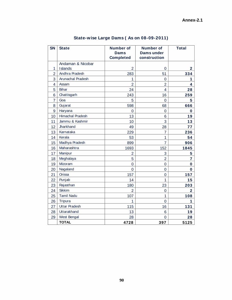
90
Annex-2.1
State-wise Large Dams ( As on 08-09-2011)
SN State Number of Dams
Completed
Number of Dams under construction
Total
1 Andaman & Nicobar Islands 2 0 2
2 Andhra Pradesh 283 51 334 3 Arunachal Pradesh 1 0 1 4 Assam 2 2 4 5 Bihar 24 4 28 6 Chattisgarh 243 16 259 7 Goa 5 0 5 8 Gujarat 598 68 666 9 Haryana 0 0 0 10 Himachal Pradesh 13 6 19 11 Jammu & Kashmir 10 3 13 12 Jharkhand 49 28 77 13 Karnataka 229 7 236 14 Kerala 53 1 54 15 Madhya Pradesh 899 7 906 16 Maharashtra 1693 152 1845 17 Manipur 2 3 5 18 Meghalaya 5 2 7 19 Mizoram 0 0 0 20 Nagaland 0 0 0 21 Orissa 157 0 157 22 Punjab 14 1 15 23 Rajasthan 180 23 203 24 Sikkim 2 0 2 25 Tamil Nadu 107 1 108 26 Tripura 1 0 1 27 Uttar Pradesh 115 16 131 28 Uttarakhand 13 6 19 29 West Bengal 28 0 28 TOTAL 4728 397 5125

91
Annex-2.2 Details of Large Dams ( As on 08-09-2011)
(Height >100m, Capacity >1Km3)
Sl No
Name of Dam
Yea
r of
co
mpl
etio
n River Height above
lowest foundation
Gross Storage capacity
Effective Storage capacity
Purpose
m km3 km3
Andhra Pradesh 1 Nagarjunasagar
Dam 1960 Krishana 125.00 11.56 5.44 I/H
2 Sriamasagar 1977 Godavari 43.00 3.17 2.32 I/H 3 Srisailam
H.E.Project 1984 Krishna 145.00 8.72 4.25 H
4 Somasila 1989 Pennar 39.00 2.21 1.99 I/S
Chhattisgarh 5 Manimata
(Hasdeo) Bango 1990 Hasdeo 87.00 3.42 3.05 I/H
Gujarat 6 Ukai 1972 Tapi 81.00 8.51 7.09 I/H/C 7 Kadana 1979 Mahi 66.00 1.54 1.20 I/H 8 Karjan 1987 Karjan 100.00 0.63 0.58 I Himachal
Pradesh
9 Bhakra Dam 1963 Sutlej 226.00 9.62 7.19 I/H 10 Pong Dam 1974 Beas 133.00 8.57 7.29 I/H 11 Chamera 1994 Ravi 140.00 0.39 0.11 H J&K
12 Salal 1986 Chenab 113.00 0.29 H 13 Baglihar 2009 Chenab 143.00 0.48 0.15 H Jharkhand
14 Maithon Dam 1957 Barakar 56.00 1.35 0.61 I/H/S/C 15 Panchet Hill 1959 Damodar 49.00 1.58 0.25 I/H/S/C 16 Tenughat 1978 Damodar 64.87 1.02 1.00 I/H/S/ Karnataka
17 Krishnarajasagar 1931 Cauvery 42.67 1.37 1.16 I/S 18 Tungabhadra 1953 Tunga-bhadra 49.38 3.77 3.71 I/H 19 Bhadra Dam 1965 Bhadra 76.81 2.03 1.79 I/H/S 20 Linganamakki
Dam 1965 Sharavathy 61.28 4.44 4.29 H
21 Malaprabha 1972 Mala-prabha 43.13 1.07 0.97 I 22 Hidkal 1977 Ghata-prabha 62.48 1.44 1.39 I/H/S 23 Hemavathy
Project 1979 Hemavathy 58.50 1.05 0.93 I/S

92
Sl No
Name of Dam
Yea
r of
co
mpl
etio
n River Height above
lowest foundation
Gross Storage capacity
Effective Storage capacity
Purpose
m km3 km3 24 Supa 1987 Kalinadi 101.00 4.18 3.76 H 25 Lakhya 1994 Lakya 108.00 0.25 0.17 T'ling/S 26 Almatti 1999 Krishna 52.24 6.42 6.00 I/H Kerala
27 Kakki Dam (KSEB)
1966 Kakki 114.00 0.46 0.45 H
28 Idukki Dam (KSEB)
1974 Periyar 169.00 1.99 1.46 H/C
29 Cheruthoni (KSEB)
1976 Cheruthoni 138.00 1.99 1.46 H/C
30 Kulamavu Dam (KSEB)
1977 Muavothupuzha
100.00 1.99 1.46 H/C
31 Idamalayar (KSEB)
1985 Idamalayar 100.00 1.15 1.02 H/C
Madhya
Pradesh
32 Gandhisagar 1960 Chambal 62.17 7.32 6.80 I/H 33 Tawa 1978 Tawa 57.91 2.31 2.05 I 34 Bargi
(R.A.B.S.Project) 1988 Narmada 69.80 3.92 3.18 I/H
35 Indira Sagar 2006 Narmada 92.00 12.20 9.75 I/H/C Maharashtra
36 Koyna 1964 Koyna 103.00 2.80 2.64 H 37 Paithan (Jayakwadi) 1976 Godavari 41.30 2.91 2.17 I/H 38 Ujjani 1980 Bhima 56.40 3.14 1.44 I/H 39 Isapur 1982 Penganga 47.00 1.25 0.95 I 40 Totladoh (Pench
Hydel) 1989 Pench 74.50 1.24 1.09 H
Orissa 41 Hirakud 1957 Mahanadi 59.00 8.14 5.82 I/H/C/S 42 Rengali 1985 Branmani 70.50 5.15 4.40 I/H 43 Upper Kolab 1985 Kolab 55.00 1.22 0.94 I/H/S 44 Indravati (Upper
Indavati project) 1996 Indrawati 45.00 2.30 1.49 I/H
45 Kapur (Upper Indavati project) 1996 Kapur 64.00 2.30 1.49 I/H
46 Muran (Upper Indavait project) 1996 Muran 65.00 2.30 1.49 I/H
47 Podgada(Upper Indavati project) 1996 Podagada 77.50 2.30 1.49 I/H
Rajasthan Bilaspur 1999 Banas 39.50 1.10 0.89 I/S Punjab
48 Thein (Ranjit Sagar)
2000 Ravi 47.00 3.28 2.34 I/H

93
Sl No
Name of Dam
Stat
us o
f co
mpl
etio
n River Height above lowest
foundation
Gross Storage capacity
Effective Storage capacity
Purpose
m km3 km3 Rajasthan
49 Ranapratapsagar 1969 Chambal 53.59 2.90 1.57 I/H/S 50 Mahi Bajaj Sagar 1985 Mahi 74.52 2.18 1.83 I/H 51 BISALPUR 1999 Banas 39.50 1.10 1.04 I/S Tamil Nadu
52 Mettur Dam 1934 Cauvery 70.41 2.71 2.65 I/H 53 Sholayar Dam 1971 Sholayar 105.16 0.15 0.14 I/H Tripura
54 Gumtihydro Dam 1975 Gumti 30.00 235.70 209.8 ha.m H
Uttaranchal
55 Ramganga 1974 Ramganga 128.00 0.25 0.22 I/H 56
Tehri (THDC) 2005
Bhagirathi 260.50 3.54 2.62 I/H
Uttar Pradesh
57 Rihand 1962 Rihand 91.46 10.60 8.90 H 58 Matatila 1964 Betwa 45.72 1.13 1.02 I/H 59 Rajghat Betwa 43.80 2.172 1.945 I/H 60 Jamrani 1990 Gola 140.00 0.21 0.21 I/H West Bengal
61 Kangsabati 1965 K.Bati/ Kumari 41.00 1.04 0.90 I/H
U/C – Under Construction, I-Irrigation , H- Hydel , C- Flood Control, S-Water Supply

94
DAMS OF NATIONAL IMPORTANCE
[Dams with height 100 m and above or with storage capacity of 1 km3 and above under construction]
Sl No
Name of Dam Status of completion
River Height above lowest
foundation
Gross Storage capacity
Effective Storage Capacity
Purpose
m km3 km3
20 Hidkal 1977 Ghata-prabha 62.48 1.44 Andhra Pradesh 1 Kandleru U/C Kandaleru 49.00 1.92 1.69 I 2 Pulichintala Project U/C Krishna 37.24 1.30 1.05 I Assam 3 Subansiri Lower HE
Project(NHPC U/C Subansiri 130.00 1.37 0.44 H
Gujarat 4 Sardar Sarovar U/C Narmada 162.00 9.50 508.00 I/H/C Himachal Pradesh 5 Kol (NTPC) UC Sutlej 167.00 0.58 90.00 H Jharkand 6 Icha at Kuju Kharkai 39.50 1.04 0.93 I 7 Chandil U/C Subarnarekha 56.50 1.96 1.61 I 8 North Koel U/C North Koel 67.86 1.17 0.96 I/H Maharasthra 9 Bham UC Tapi 67.50 1.79 1.58 I Uttaranchal
15 Kishau U/C Tons 236.00 1.81 1.33 I/H 16 Lakhwar U/C Yamuna 204.00 0.58 0.33 I/H 17 Vyasi U/C Yamuna 88.00 1.16 I/H
U/C – Under Construction, I-Irrigation , H- Hydel , C- Flood Control, S-Water Supply

95
Annex-2.3 Flood Affected area compiled by XI Plan Working Group on
Water Resources
(Area in Lakh ha.)
Sl. No.
Name of States/UTs Area Liable to Floods as Assessed by RBA
Flood Affected Area as compiled by XI Plan
Working Group (A) STATES 1 Andhra Pradesh 13.90 34.802 Arunachal Pradesh 0.823 Assam 31.50 38.204 Bihar * 42.60 68.805 Chattisgarh - -6 Delhi (NCT) 0.50 0.707 Goa 8 Gujarat 13.90 20.509 Haryana 23.50 23.5010 Himachal Pradesh 2.30 2.3111 Jammu & Kashmir 0.80 5.1412 Jharkhand - -13 Karnataka 0.20 9.0014 Kerala 8.70 14.7015 Madhya Pradesh * 2.60 3.3716 Maharashtra 2.30 3.3017 Manipur 0.80 0.8018 Meghalaya 0.20 0.9519 Mizoram - 0.5420 Nagaland - 0.0921 Orissa 14.00 33.4022 Punjab 37.00 40.5023 Rajasthan 32.60 32.6024 Sikkim - 0.2025 Tamil Nadu 4.50 4.5026 Tripura 3.30 3.3027 Uttar Pradesh * 73.36 73.4028 Uttaranchal - -29 West Bengal 26.50 37.66 Sub-Total 335.06 455.9030 Andaman & Nicobar
Islands - -
31 Chandigarh - -32 Dadra & Nagar Haveli - -33 Daman & Diu - -34 Lakshadweep - -35 Pondicherry 0.10 0.50 Sub-Total(UTs) 0.10 - Grand Total 335.16 456.40
* Figures are before bifurcation
Area liable to floods as assessed by RBA (i) Sum of the maxima of flood affected area in a year (from 1953 to
1980 Protected area upto 1978 = 33.516 mha, say 34 mha
(ii) Total protected area upto 1978 = 10 mha (iii) Deduction for protected area included under flood affected area
due to breach / failure of protection = 4 mha
Area liable to floods = (i) + (ii) - (iii) = 34 + 10 - 4 = 40 mha

96
Annex-2.4
State -wise Maximum Area Affected by Floods in any year during 1953-2010
SN State Max. Area affected ( mha)
Year of Maximum Area affected
(1) (2) (3) (4) 1 Andhra Pradesh 9.040 20052 Arunachal Pradesh 0.207 20033 Assam 3.820 19884 Bihar 4.986 20045 Chhattisgarh 0.089 20016 Delhi 0.458 19977 Goa 0.000 08 Gujarat 2.050 19889 Haryana 1.000 197710 Himachal Pradesh 2.870 199911 Jammu & Kashmir 0.514 198712 Jharkhand 0.000 013 Karnataka 0.900 198814 Kerala 1.470 198915 Madhya Pradesh 0.377 199416 Maharashtra 0.391 200217 Manipur 0.080 198918 Meghalaya 0.095 198719 Mizoram 0.541 199320 Nagaland 0.009 199321 Orissa 1.400 196022 Punjab 2.790 198823 Rajasthan 3.260 197724 Sikkim 1.170 200025 Tamil Nadu 1.466 201026 Tripura 0.330 196327 U.P. 7.340 197828 Uttarakhand 0.002 200129 West Bengal 3.080 197830 Andaman&Nicobar 0.030 198831 Chandigarh 32 Dadra & Nagar Haveli33 Daman & Diu 34 Lakshadweep 35 Puducherry 0.050 1977
Total 49.815 Source:- as per the reports received in CWC from State Revenue Authorities & MHA

97
Annex-2.5
Physical Achievements of Flood Management Works till March, 2006
S.No.
Name of States /UTs
Area Benefited
Length of embankments
Length of drainage channel
Village raised/ protected
Town/ village
protection works
Raised Platforms
Mha Km Km (Nos) (Nos) (Nos) 1 2 3 4 5 6 7 1 Andhra Pradesh 1.311 2230.000 13569.000 23 72 2 Arunachal Pradesh 0.055 6.324 4.447 17 03 Assam 1.642 4464.180 850.690 0 6944 Bihar 2.949 3430.000 365.000 0 47 585 Chattisgarh 0.000 0.000 0.000 0 06 Delhi 0.078 83.000 453.000 0 07 Goa 0.003 23.190 32.770 0 28 Gujarat 0.483 104.120 271.000 30 8059 Haryana 2.000 1144.000 4385.000 98 448
10 Himachal Pradesh 0.012 58.000 11.000 0 011 Jammu & Kashmir 0.217 230.000 14.000 5 1212 Jharkhand 0.001 14.000 0.000 5 213 Karnataka 0.005 73.515 10.000 0 3014 Kerala 0.346 205.744 31.100 6 415 Madhya Pradesh 0.004 26.000 0.000 0 3716 Maharashtra 0.001 44.500 110.000 0 017 Manipur 0.132 577.000 166.000 1 3818 Meghalaya 0.001 112.000 0.000 2 819 Mizoram 0.000 0.000 0.000 0 020 Nagaland 0.632 10.519 0.000 0 821 Orissa 0.630 6541.000 131.000 14 2922 Punjab 3.190 1370.000 6622.000 0 323 Rajasthan 0.082 145.000 197.000 0 2524 Sikkim 0.017 101.810 64.860 0 1825 Tamil Nadu 0.122 87.000 19.000 4 4626 Tripura 0.033 141.740 95.230 0 1127 Uttar Pradesh 1.703 2097.000 3995.000 4511 6528 Uttaranchal 0.002 9.000 0.000 0 629 West Bengal 2.568 10539.000 7392.760 00 48
Union Territories 0 30 A & N Islands 0.000 0.000 0.000 0 031 Chandigarh 0.000 0.000 0.000 0 032 Dadra & Nagar Haveli 0.000 0.000 0.000 0 033 Daman & Diu 0.000 0.000 0 034 Lakshadweep 0.000 0.000 0.000 0 035 Pondicherry 0.004 61.000 20.000 0 0
Total 18.222 33928.642 38809.857 4716 2458 58

98
Annex-7.1
State-wise Details of A, B-1, B-2 and C-Class cities Located near Rivers and details of existing Level Forecast Stations of CWC
Sl.No:
State C-Class Cities
A, B-1 and B-2 Class Cities
Total Existing
Level Forecast Stations
Additional Level
Forecast Stations Required
1 Andhra Pradesh 83 5 88 9 792 Assam 13 1 14 24 03 Bihar 47 1 48 32 164 Karnataka 51 6 57 1 565 Madhya Pradesh 49 3 52 2 506 Gujarat 56 6 62 6 567 Chattisgarh 12 3 15 0 158 Kerala 24 3 27 0 279 Haryana 25 1 26 0 26
10 Orissa 22 2 24 11 1311 Maharashtra 73 9 82 7 7512 Punjab 32 3 35 0 3513 Rajasthan 45 4 49 0 4914 Uttarakhand 7 1 8 3 515 Jharkhand 2 2 4 1 316 Puduchery 2 0 2 0 217 Jammu & kashmir 6 2 8 0 818 Goa 3 0 3 0 319 Tamilnadu 70 6 76 0 7620 Uttarpradesh 105 10 115 34 8121 West bengal 42 2 44 11 3322 UT Chandigarh 0 1 1 0 123 Tripura 2 2 2 024 Delhi 1 1 2 0
25 Dadara & Nagar Haveli 2 2 2 0
Total: 773 72 845 147 709

99
Annex-7.2
List of Reservoirs/Barragrs under Existing Inflow Forecasting Network of CWC (28 nos.)
SN Name of Reservoir State Live Capacity at FRL (BCM)
1 Gotta Barrage Andhra Pradesh - 2 Sriram Sagar Andhra Pradesh - 3 Singur Dam Andhra Pradesh 566 4 Nizamsagar Dam Andhra Pradesh 479 5 Priyadarshini Project Andhra Pradesh - 6 Srisalem Dam Andhra Pradesh 8288 7 Prakashan Barrage Andhra Pradesh - 8 Dantiwada Dam Gujarat 399 9 Dharol Dam Gujarat 735 10 Kadana Dam Gujarat 1472 11 Ukai Dam Gujarat 6615 12 Madhuban Dam Gujarat 502 13 Tajewala Headworks Haryana - 14 Tenughat Dam Jharkhand 821 15 Maithon Dam Jharkhand 471 16 Panchet Dam Jharkhand 184 17 Almati Dam Karnataka 3105 18 Narayanpur Dam Karnataka 863 19 Tungabhadra Dam Karnataka 3276 20 Gandhisagar Dam Madhya Pradesh 6827 21 Jakwadi Dam Maharashtra - 22 Hatnur Dam Maharashtra 255 23 Hirakud Dam Orissa 5378 24 Narora Barrage Uttar Pradesh - 25 Masanjore Dam Jharkhand - 26 Tilpara Barrage West Bengal - 27 Durgapur Barrage West Bengal - 28 Kangsabati Dam West Bengal 914

100
Annex-7.3
List of Additional Reservoirs Proposed under Inflow Forecasting Network of CWC (96 nos.)
SN Name of Reservoir State Live Capacity
at FRL (MCM) 1 Nagarjuna Sagar Andhra Pradesh 68412 Sriramsagar Andhra Pradesh 23003 Somasila Andhra Pradesh 19944 Lower Manair Andhra Pradesh 6215 Donkaravi Dam Andhra Pradesh 12536 Vamsadhara Stage -I Andhra Pradesh 4657 Lower Sileru H.E Andhra Pradesh 3788 Myalavaram Andhra Pradesh 2659 Thotapalli Res. Andhra Pradesh 258
10 Yelleru Andhra Pradesh 50811 Subansiri Assam 44212 Durgawati Bihar 25813 Upper Sakri Bihar 25114 Lower Kiul Bihar 25115 North Keol Bihar 96016 Jalkund Bihar 23117 Salauli Goa 22718 Tandula Chhattisgarh 30219 Dudhava Chhattisgarh 28420 Minimata Bangoi Chhattisgarh 304621 Mahanadi Chhattisgarh 76722 Panam Gujarat 68023 Karjan Gujarat 58124 Sipu Gujarat 39925 Sardar Sarovar Project Gujarat 580026 Pedcholi Gujarat 73527 Palltiana Gujarat 34828 Shetrunji Gujarat 30029 Bhadar Gujarat 18830 Damanaganga Gujarat 50231 Panam Gujarat 69732 Gobind Sagar(Bhakra) Himachal Pradesh 622933 Pong Dam Himachal Pradesh 615734 Chamera Ii Himachal Pradesh 35 Gatalsud Jharkhand 23136 Konar Jharkhand 17637 Mani Karnataka 88338 Tatihalla Karnataka 24939 Sharavati Karnataka 4352
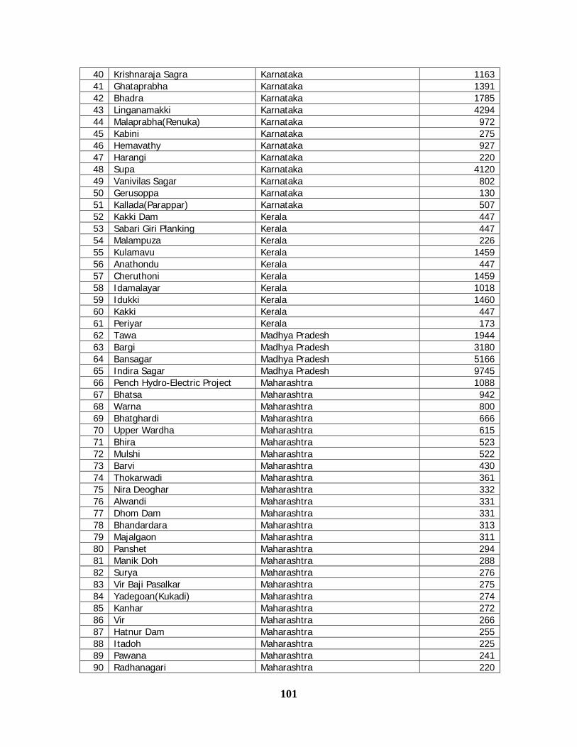
101
40 Krishnaraja Sagra Karnataka 116341 Ghataprabha Karnataka 139142 Bhadra Karnataka 178543 Linganamakki Karnataka 429444 Malaprabha(Renuka) Karnataka 97245 Kabini Karnataka 27546 Hemavathy Karnataka 92747 Harangi Karnataka 22048 Supa Karnataka 412049 Vanivilas Sagar Karnataka 80250 Gerusoppa Karnataka 13051 Kallada(Parappar) Karnataka 50752 Kakki Dam Kerala 44753 Sabari Giri Planking Kerala 44754 Malampuza Kerala 22655 Kulamavu Kerala 145956 Anathondu Kerala 44757 Cheruthoni Kerala 145958 Idamalayar Kerala 101859 Idukki Kerala 146060 Kakki Kerala 44761 Periyar Kerala 17362 Tawa Madhya Pradesh 194463 Bargi Madhya Pradesh 318064 Bansagar Madhya Pradesh 516665 Indira Sagar Madhya Pradesh 974566 Pench Hydro-Electric Project Maharashtra 108867 Bhatsa Maharashtra 94268 Warna Maharashtra 80069 Bhatghardi Maharashtra 66670 Upper Wardha Maharashtra 61571 Bhira Maharashtra 52372 Mulshi Maharashtra 52273 Barvi Maharashtra 43074 Thokarwadi Maharashtra 36175 Nira Deoghar Maharashtra 33276 Alwandi Maharashtra 33177 Dhom Dam Maharashtra 33178 Bhandardara Maharashtra 31379 Majalgaon Maharashtra 31180 Panshet Maharashtra 29481 Manik Doh Maharashtra 28882 Surya Maharashtra 27683 Vir Baji Pasalkar Maharashtra 27584 Yadegoan(Kukadi) Maharashtra 27485 Kanhar Maharashtra 27286 Vir Maharashtra 26687 Hatnur Dam Maharashtra 25588 Itadoh Maharashtra 22589 Pawana Maharashtra 24190 Radhanagari Maharashtra 220

102
91 Bhama Askhed Maharashtra 21792 Dhamni Maharashtra 27393 Dudhganga Maharashtra 67994 Tillari Maharashtra 44795 Urmodi Maharashtra 27396 Pench Hydro-Electric Project Maharashtra 108897 Bhatsa Maharashtra 94298 Warna Maharashtra 80099 Bhatghardi Maharashtra 666
100 Jayakwadi(Paithon) Maharashtra 2171101 Koyana Maharashtra 2652102 Bhima(Ujjani) Maharashtra 1517103 Isapur Maharashtra 965104 Mula Maharashtra 609105 Yeldari Maharashtra 809106 Girna Maharashtra 524107 Khadakvasla Maharashtra 56110 Upper Vaitarna Maharashtra 331111 Upper Tapi Maharashtra 255112 Pench (Totaladoh) Maharashtra 1091113 Loktak Manipur 397114 Kydemkulai Meghalaya 326115 Dayang Nagaland 1220116 Balimela Orissa 2676117 Salanadi Orissa 558118 Rengali Orissa 3432119 Machkund(Jalput) Orissa 893120 Upper Kolab Orissa 935121 Upper Indravati Orissa 1456122 Mardiar Orissa 370123 Mandira Orissa 311124 Kapur Orissa 1490125 Sapna Orissa 660126 Thein Punjab 2344127 Ranjit Sagar( Thein) Punjab 2344128 Mahi Bajaj Sagar Rajasthan 1711129 Jhakam Rajasthan 132130 Rana Pratap Sagar Rajasthan 1436131 Ram Sagar Rajasthan 933132 Urmil Sagar Rajasthan 535133 Bisalpur Rajasthan 1040134 Lower Bhawani Tamil Nadu 792135 Mettur(Stanley) Tamil Nadu 2647136 Vaigai Tamil Nadu 172137 Parambikulam Tamil Nadu 380138 Aliyar Tamil Nadu 95139 Sholayar Tamil Nadu 143140 Periyar @ Tamil Nadu 299141 Bhavanisagar Tamil Nadu 908142 Upper Aliyar Tamil Nadu 259143 Sathanur Tamil Nadu 9

103
144 Gumti Tripura 312145 Matatila Uttar Pradesh 707146 Rihand Uttar Pradesh 5649147 Maudaha Uttar Pradesh 480148 Sarda Sagar St.- Ii Uttar Pradesh 417149 Sarda Sagar St.- I Uttar Pradesh 364150 Nunauti Uttar Pradesh 340151 Meja Res. Uttar Pradesh 283152 Chitturgarh Uttar Pradesh 388153 Dhandhraul Uttar Pradesh 139.5154 Rangwan Uttar Pradesh 155155 Jirgo Uttar Pradesh 133156 Sirsi Uttar Pradesh 195157 Ramganga Uttarakhand 2196158 Tehri Uttarakhand 2615159 Jamrani I Uttarakhand 207160 Mayurakshi West Bengal 480

104
Annex- 8.1
Requirement of Funds under Flood Management Programme During XII Plan
Rs. in crore SN Name of State / Project Estimated
Cost Central Share
Status
A Balance Central Share spilling over to XII Plan 1172.35 B Projects accosting Rs. 100 crore and above in pipeline 1 Assam
1.1 Protection of Biswanath to Panpur against erosion due to Brahmaputra
167.09 150.38 Cleared by TAC. Yet to be included under FMP.
1.2 Construction of dykes on Brahmaputra ( Dhing to Hilloikhunda)
187.97 169.17 Under examination in CWC
1.3 Protection of Rohmaria Area 344.17 309.75 Under examination in CWC 1.4 Anti-erosion measures in Buridhing 129.31 116.38 Under examination in CWC 1.5 Protection of Kaziranga National Park 177.56 159.80 Under examination in CWC 1.6 Protection of dykes in Brahmaputra (Sissikalghar
to Tekeliphuta) 100.34 90.31 Under examination in CWC
1.7 R/S of Ranganadi embankments 182.67 164.40 Under examination in CWC 1.8 Flood / Erosion control in Puthimari 127.10 114.39 Under examination in CWC
Sub-total ( Assam) 1416.21 1274.59 2 Bihar
2.1 Baghmati flood management scheme 535.98 401.99 Under examination in GFCC 2.2 Mahananda embankment Scheme 756.13 567.10 Under examination in GFCC 2.3 R/S of embankments of Chandan River 221.82 166.37 Under examination in GFCC
Sub-total ( Bihar) 1513.93 1135.45 3 Gujarat
Construction of 56 km long sea wall 338.26 253.70 NCPP Project under examination in CWC
Sub-total ( Gujarat) 338.26 253.70 4 Himachal Pradesh
4.1 New Projects 200.00 180.00 DPR under preparation Sub-total ( HP) 200.00 180.00
5 J&K 5.1 Comprehensive Flood Management in River
Jhelum and its tributaries 2083.90 1875.51 Under examination in CWC
5.2 Training / FPW on Chenab in Distt-Jammu 1000.00 900.00 DPR Under preparation 5.3 Training / FPW on Tawiin Distt-Jammu 250.00 225.00 DPR Under preparation 5.4 FPW in river Ujh in Distt-Kathua 105.00 94.50 DPR Under preparation 5.5 FPW / AE works on Neru Nallah 100.00 90.00 DPR Under preparation 5.6 FPW on local Nallah of Distt Jammu, Sambha and
Kathua 160.00 144.00 DPR Under preparation
Sub-total ( J&K) 3698.90 3329.01 6 Karnataka
6.1 Construction of 49.875 m= km long sea wall reformation of 17.65 km long old damaged walls
291.72 218.79 NCPP Project under examination in CWC
Sub-total ( Karnataka) 291.72 218.79 7 Kerala
7.1 Mitigation of floods in Kutanad, Region, Phase-II 1387.07 1040.30 Under examination in CWC 7.2 Mitigation of floods in Kutanad, Region, Phase-III 677.77 508.33 Under examination in CWC 7.3 Mitigation of flood in Ontukara Region 248.39 186.29 Cleared by TAC. 7.4 Construction of 52.07 km sea wall, 21 groynes,
reformation of 59.45 km old walls 222.90 167.18 NCPP Project under
examination in CWC Sub-total ( Kerala) 2536.13 1902.10

105
SN Name of State / Project Estimated
Cost Central Share
Status
8 Maharashtra 8.1 Construction of 72.36 km sea wall. 187.60 140.70 NCPP Project under
examination in CWC Sub-total ( Maharashtra) 187.60 140.70
9 Odisha 9.1 Subernrekha Sanskar Project 949.14 711.86 Under examination in
CWC 9.2 Construction of 89.5 km sea wall, 75 saline
embankments, protection tidal reaches of rivers, creeks, etc.
357.59 268.1925 NCPP Project under examination in CWC
Sub-total ( Orissa) 1306.73 980.05 10 Sikkim
10.1 Master Plan of storm water drainage system for Gangtok
100.21 90.19 Under examination in CWC
Sub-total ( Sikkm) 100.21 90.19 11 Tamil Nadu
11.1 Construction of 19.80 km long sea wall.
166.43 124.82 NCPP Project under examination in CWC
Sub-total ( Tamil Nadu) 166.43 124.82 12 Uttar Pradesh
12.1 New Projects 500.00 375.00 DPR Under preparation Sub-total ( Uttar Pradesh)
500.00 375.00
13 Uttarakhand 13.1 New Projects 350.00 315.00 DPR Under preparation
Sub-total ( Uttar Pradesh) 350.00 315.00 14 West Bengal
14.1 Aila, Phase-II 3692.50 2769.38 Under examination in GFCC
14.2 Improvement of embankments in river Kandi 523.18 392.39 Under examination in GFCC
14.3 Master Plan for Ghatal Area 1740.00 1305.00 Under examination in GFCC
14.4 10.75 km beach protection and 36.50 km tidal protection
252.76 189.57 NCPP Project under examination in CWC
Sub-total ( West Bengal) 6208.44 4656.33 TOTAL(B) 18814.56 14975.72 G. TOTAL( A+B) 18814.56 16148.07
Provision Recommended under FMP for XII Plan = Rs. 16000 crore