geothermal energy in argentina - cadicaa.com.ar –tocomar (salta-jujuy) project location •the...
TRANSCRIPT

Geothermal Energy in ArgentinaInvestment Projects 2010

Valle del Cura (San Juan) Project
• The geothermal fields (29° 35 'latitude south and 69°
45' west longitude) are located in the Northwest high
cordillera (aprox. 3.800 m.a.s.l.) Central Andes of
San Juan province, Argentina, 10 to 20 km away
from the Argentina-Chile border. The location is
known locally as “Valle del Cura”.
• The landscape is dominated for an elevated flat area
elongated N-S bordered to East and West by
mountain chains.
• The red dot shows the area of mining rights of
Geotermia Andina.
• The following page include a detailed graph of the
region.
Location

• In 1914, De Thierry briefly discovered the abundance
of hot-springs spots in Valle del Cura area.
• From 1982 to 1985 many consulting firms performed
grass-roots exploration in the area (Geomines SA,
Hydroproyectos SA, etc) and describe the interesting
geothermal features, suggesting continuing with the
exploration to define the capability of electric power
generation.
• From 1985 to date no serious researching has been
done related to geothermic in the area, mainly
because of the lack of market for a possible electrical
generation capacity.
Valle del Cura (San Juan) Project
Background
Las Tortolas volcano and its related coladas and ignimbrites.
Source: Geotermia Andina SA

• The properties consist on five mining concessions
with a total amount of 21.000 hectares covering 95%
of the geothermal fields in the region.
• The figure shows the location of the mining rights.
Argentina
Chile
Valle del Cura (San Juan) Project
Mining Rights Area
Source: Geotermia Andina SA

Valle del Cura (San Juan) Project
Details of hot-spring location, temperature and geo-thermometers (in Celsius).
Source: Geotermia Andina SA
Sample# East North
Na-K Fournier(ºC)
Ca-Na Tonani(ºC)
Ca-K Tonani (ºC)
M1207-1 2431501 6772909
184 156 254
M1207-2 2431491 6772870
185 154 158
M1207-3 2435717 6768006
219 340 267
M1207-4 2427793 6725753
210 220 205
M1207-5 2427799 6725749
208 400 210
M1207-6 2427796 6725745
199 390 205
M1207-7 2423990 6717061
230 253 157
M1207-8 2424000 6717062
235 310 165

Tuzgle – Tocomar (Salta-Jujuy) Project
Location
• The geothermal field Tuzgle-Tocomar (23° 55 'latitude south
and 66° 05' west longitude), is located in the central plateau of
La Puna, elevated over 4000 m.a.s.l. within the border of
Salta-Jujuy provinces in Argentina.
• Research is currently going through the final stage of pre-
feasibility, which has been studied in detail an area of
approximately 900 square kilometers.
• It is the most studied geothermal field in the Northwest of
Argentina. Between 1978 and 1995 there was a sequence of
studies that spanned from grass-roots until the delimitation of
an area where deep exploratory wells should be executed.
• The red dot shows the area of mining rights of Geotermia
Andina.
• The following page include a detailed graph of the region
Source: Geotermia Andina SA

Source: Geotermia Andina SA
Tuzgle – Tocomar (Salta-Jujuy) Project
Tuzgle Volcano.

• The property consists of six
mining concessions which
include an aggregate total of
25,416 hectares covering
almost 60% of the geothermal
fields.
• The figure shows the location
of the mining rights.
Mining Rights
Source: Geotermia Andina SA
Tuzgle – Tocomar (Salta-Jujuy) Project
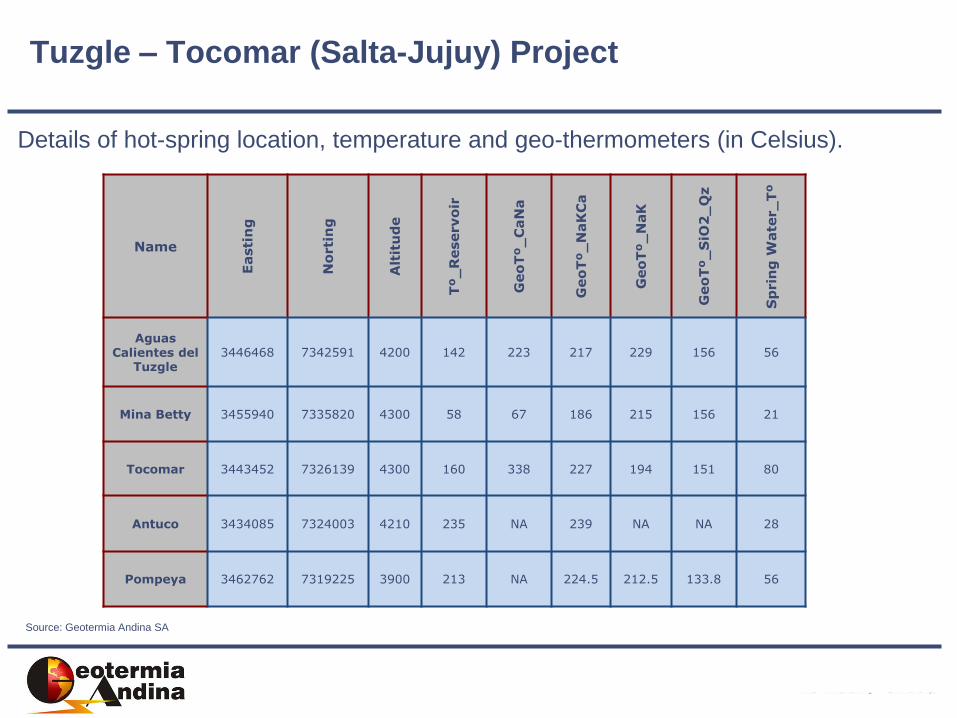
Details of hot-spring location, temperature and geo-thermometers (in Celsius).
Source: Geotermia Andina SA
Tuzgle – Tocomar (Salta-Jujuy) Project
NameE
asti
ng
No
rti
ng
Alt
itu
de
Tº_
Reservo
ir
Geo
Tº_
CaN
a
Geo
Tº_
NaK
Ca
Geo
Tº_
NaK
Geo
Tº_
SiO
2_
Qz
Sp
rin
g W
ate
r_
Tº
Aguas Calientes del
Tuzgle3446468 7342591 4200 142 223 217 229 156 56
Mina Betty 3455940 7335820 4300 58 67 186 215 156 21
Tocomar 3443452 7326139 4300 160 338 227 194 151 80
Antuco 3434085 7324003 4210 235 NA 239 NA NA 28
Pompeya 3462762 7319225 3900 213 NA 224.5 212.5 133.8 56

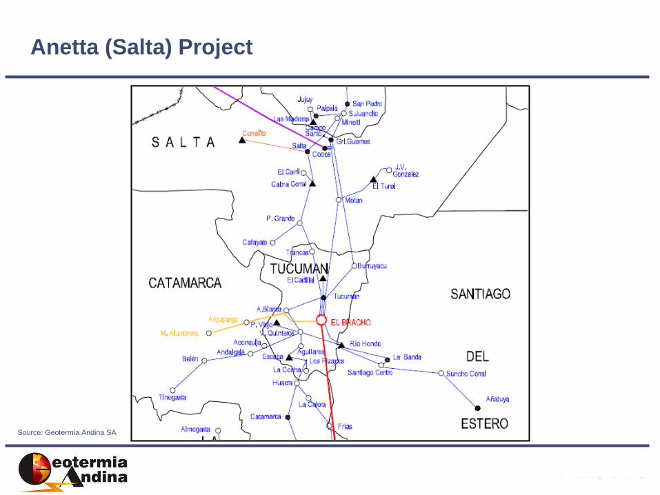
Anetta (Salta) Project
The project is located close to
Rosario de la Frontera City, 170 km
south from Salta’s capital province,
Argentina.
The landscape is dominated by
flat areas and mountain ridges
elongated North-South.
Land is used for cattle, soy beam-
sunflower-tobacco and sugar cane
crops. Together, there are many
industries for processing those
commodities.
Location
Source: Geotermia Andina SA

Source: Geotermia Andina SA
Local sign indicating hot spring (87º).
Anetta (Salta) Project

Source: Geotermia Andina SA
PROPERTIES
The property
consists on one
mining concession
with a total amount of
6553 hectares,
covering almost
100% of the
geothermal field.
Anetta (Salta) Project

Sample #
Geo
Tº_
Na-K
Geo
Tº_
SiO
2
_Q
z
Sp
rin
g
Wate
r_
Tº
M1 203 130.0 89.2
M2 270 130.0 75.6
M3 220 129.0 84.3
M4 175 124.0 52.8
M5 263 127.0 76.2
M6 261 96.0 25
M7 ND ND 68
M8 ND ND 72
M9 ND ND 76
M10 ND ND 63.2
M11 ND ND 79
M12 ND ND 84
M13 ND ND 99
M14 ND ND 87
Anetta (Salta) Project
Source: Geotermia Andina SA
Anetta (Salta) Project
Source: Geotermia Andina SA
Investment Projects – Argentina - 2010