geotek engineering & testing services, inc. 909 east 50th ... · geotek engineering &...
TRANSCRIPT

GEOTEK ENGINEERING & TESTING SERVICES, INC. 909 East 50th Street North Sioux Falls, South Dakota 57104 Phone 605-335-5512 Fax 605-335-0773
January 3, 2017
Codington County 14 1st Avenue SE Watertown, South Dakota 57201 Attn: Lee Gabel Subj: Preliminary Geotechnical Exploration Proposed Justice Facility Codington County U.S. Highway 212 Watertown, South Dakota GeoTek #16-E56
Introduction
This correspondence presents our reporting of the preliminary geotechnical exploration program for the referenced project. Our work was performed in accordance with your authorization.
Project Location & Description
The project site is located northwest of the intersection of U.S. Highway 212 and 25th Street SW in Watertown, South Dakota. Currently, the site is vacant and snow covered. A grade change of approximately 10 feet occurs across the site. The site slopes downward from the north to the south.
Test Borings
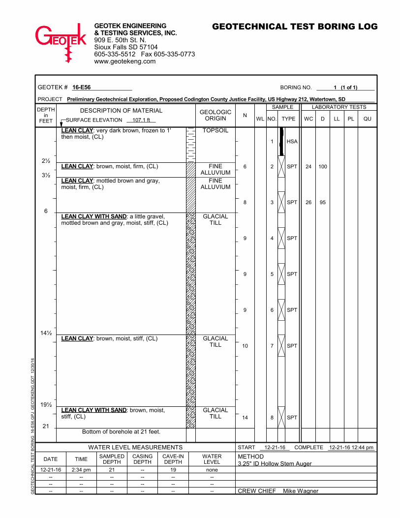
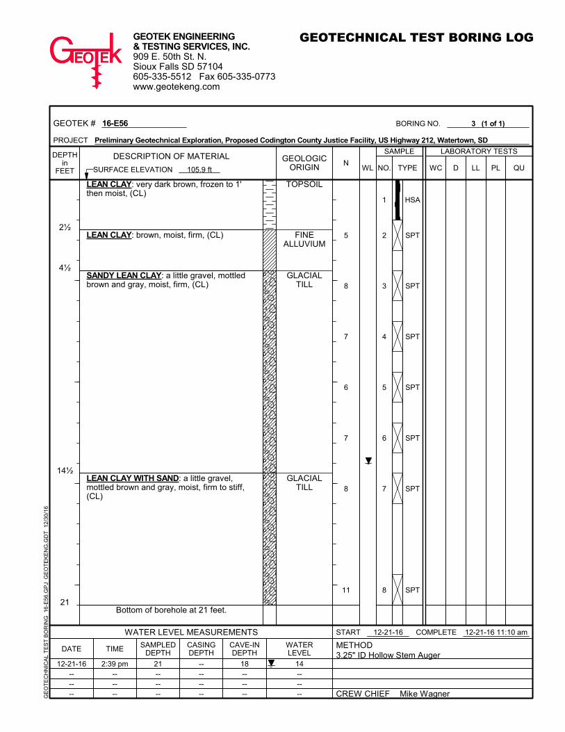
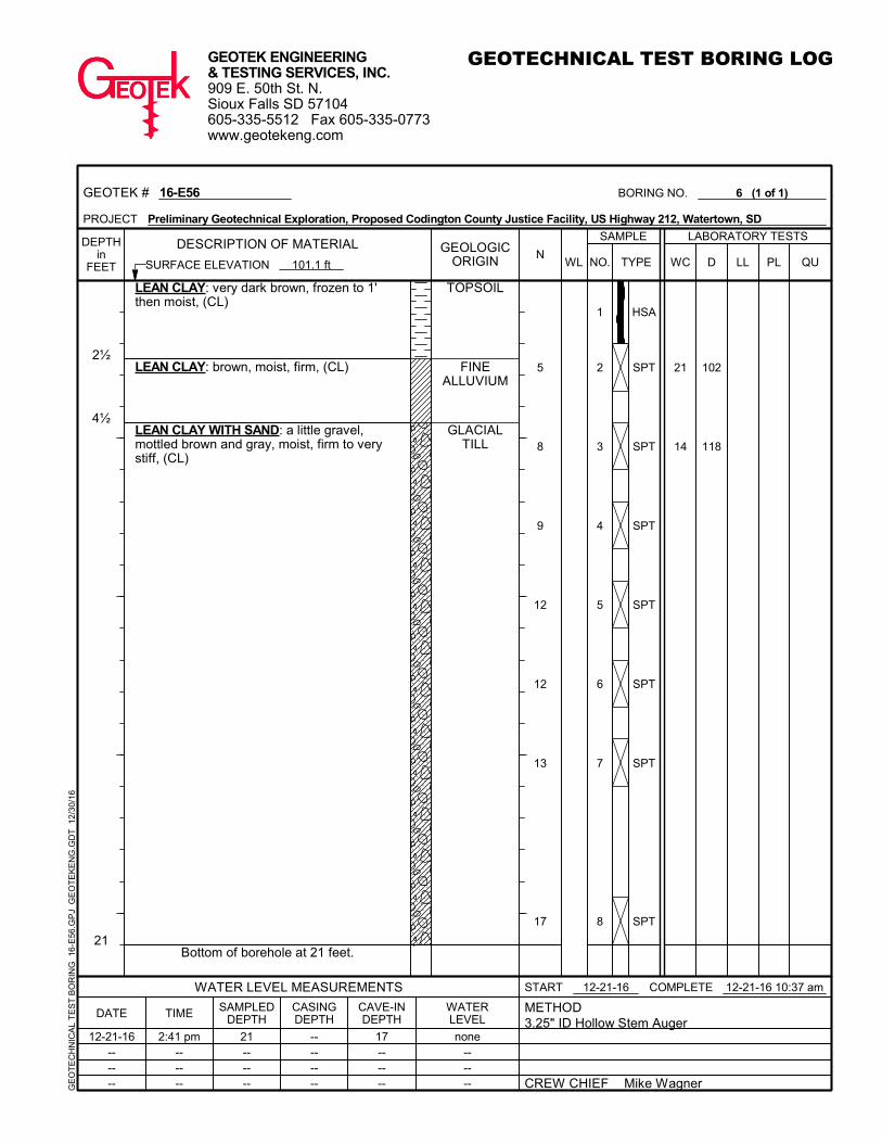
We performed six (6) test borings at the site on December 21, 2016. A test boring location map is attached showing the relative location of the test borings. The ground surface elevations at the test boring locations were determined by using the top of the fire hydrant located at the south edge of the site as a benchmark. An arbitrary elevation of 100.0 feet was used for the benchmark. A test boring location map, showing the relative location of the test borings, is attached at the conclusion of this report.
Subsurface Conditions
The subsurface conditions encountered at the test boring locations consisted of 1 ½ feet to 2 ½ feet of topsoil materials overlying fine alluvium soils and glacial till soils. The glacial till soils were the predominant soil type encountered and extended to the termination depth of the test borings.

Proposed Justice Facility – U.S. Highway 212 Page 2 of 3 Watertown, South Dakota GeoTek 16-E56
GeoTek Engineering & Testing Services, Inc.
The topsoil materials consisted of lean clay soils. The fine alluvium soils consisted of lean clay soils and lean clay with sand soils. The glacial till soils consisted of lean clay with sand soils and sandy lean clay soils.
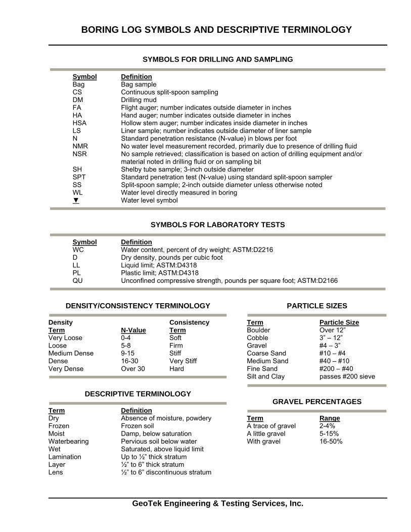
The consistency or relative density of the soils is indicated by the standard penetration resistance (“N”) values as shown on the boring logs. A description of the soil consistency or relative density based on the “N” values can be found on the attached Soil Boring Symbols and Descriptive Terminology data sheet.
Groundwater Levels
Measurements to record the groundwater levels were made at the test boring locations. The time and level of the groundwater readings are recorded on the boring logs. Groundwater was measured at a depth of 14 feet at test borings 2 and 3. Groundwater did not enter the boreholes at the remaining test borings at the time of our measurements.
The water levels indicated on the boring logs may or may not be an accurate indication of the depth or lack of subsurface groundwater. The limited length of observation restricts the accuracy of the measurements. A long period of time is generally required for subsurface water to stabilize in the boreholes. Long term groundwater monitoring was not included in our work scope.
Laboratory Testing
Select samples from the test borings were submitted to the laboratory for testing. The tests consisted of moisture content, dry density and unconfined compressive strength. The results of the laboratory tests are shown on the boring logs adjacent to the samples upon which the tests were performed.
Project Information
We understand that a new justice facility may be constructed at the site. The proposed justice facility will consist of a building and pavement areas. No loading information is available and no grading plans have been developed.
Discussion
The test borings encountered 1 ½ feet to 2 ½ feet of topsoil materials overlying fine alluvium soils and glacial till soils. It is our opinion that the topsoil materials are not suitable for support of the footings or floor slab of the proposed building. Regarding the fine alluvium soils and glacial till soils, it is our opinion that these two (2) soil types have different supporting characteristics (net allowable soil bearing capacities). In our opinion, a net allowable soil bearing capacity of up to 2,000 pounds per square foot (psf) could be expected for the fine alluvium soils, while a net allowable soil bearing capacity of up to 3,500 psf could be expected for the glacial till soils.
In our opinion, the site preparation within the footing areas of the building would depend on which net allowable soil bearing pressure is used for the design of the footings. If a net allowable soil bearing pressure of up to 2,000 psf is used, then the site preparation in the footing areas of the building would likely consist of removing the topsoil materials in order to expose the fine alluvium soils or glacial till soils. If a net allowable soil bearing pressure of up to 3,500 psf is used, then the


September 20, 2016 Project #: 2117.01
Codington County Justice Facilities StudySOIL BORING LOCATIONS
30’ SETBACK
PROPERTY LINE
20’ S
ET
BA
CK
PR
OP
ER
TY
LIN
E
40’ SETBACK
PROPERTY LINE
20’ SETBAC
K
PROPERTY LIN
E
212 / 9TH AVE SW
SCALE: 1” = 100’-0”
B1 B2
B3
B6
B4
B5
1
2
3
4
5
6
7
8
24
26
100
95
HSA
SPT
SPT
SPT
SPT
SPT
SPT
SPT
6
8
9
9
9
10
14
2½
3½
6
14½
19½
21
TOPSOIL
FINEALLUVIUM
FINEALLUVIUM
GLACIALTILL
GLACIALTILL
GLACIALTILL
LEAN CLAY: very dark brown, frozen to 1'then moist, (CL)
LEAN CLAY: brown, moist, firm, (CL)
LEAN CLAY: mottled brown and gray,moist, firm, (CL)
LEAN CLAY WITH SAND: a little gravel,mottled brown and gray, moist, stiff, (CL)
LEAN CLAY: brown, moist, stiff, (CL)
LEAN CLAY WITH SAND: brown, moist,stiff, (CL)
Bottom of borehole at 21 feet.
--------
LABORATORY TESTS
DATE TIME SAMPLEDDEPTH
GEOTECHNICAL TEST BORING LOG
21------
CASINGDEPTH
CAVE-INDEPTH
19------
WATERLEVEL
BORING NO. 1 (1 of 1)
12-21-16------
2:34 pm------
none------
PROJECT Preliminary Geotechnical Exploration, Proposed Codington County Justice Facility, US Highway 212, Watertown, SD
NO. WC D PL QULLTYPEN
GE
OT
EC
HN
ICA
L T
ES
T B
OR
ING
16-
E56
.GP
J G
EO
TE
KE
NG
.GD
T 1
2/30
/16
GEOTEK # 16-E56
WATER LEVEL MEASUREMENTS
METHOD3.25" ID Hollow Stem Auger
SURFACE ELEVATION 107.1 ft
DEPTHin
FEET
COMPLETE 12-21-16 12:44 pmSTART 12-21-16
909 E. 50th St. N.Sioux Falls SD 57104605-335-5512 Fax 605-335-0773www.geotekeng.com
GEOLOGICORIGIN
CREW CHIEF Mike Wagner
SAMPLE
GEOTEK ENGINEERING& TESTING SERVICES, INC.
DESCRIPTION OF MATERIALWL

1
2
3
4
5
6
7
8
21
14
101
116 5000
HSA
SPT
SPT
SPT
SPT
SPT
SPT
SPT
6
10
12
14
13
12
15
2
4½
14½
19½
21
TOPSOIL
FINEALLUVIUM
GLACIALTILL
GLACIALTILL
GLACIALTILL
LEAN CLAY: very dark brown, frozen to 1'then moist, (CL)
LEAN CLAY: brown, moist, firm, (CL)
LEAN CLAY WITH SAND: a little gravel,mottled brown and gray, moist, stiff, (CL)
SANDY LEAN CLAY: mottled brown andgray, moist to wet, stiff, (CL)
LEAN CLAY WITH SAND: brown, moist,stiff, (CL)
Bottom of borehole at 21 feet.
--------
LABORATORY TESTS
DATE TIME SAMPLEDDEPTH
GEOTECHNICAL TEST BORING LOG
21------
CASINGDEPTH
CAVE-INDEPTH
18------
WATERLEVEL
BORING NO. 2 (1 of 1)
12-21-16------
2:38 pm------
14------
PROJECT Preliminary Geotechnical Exploration, Proposed Codington County Justice Facility, US Highway 212, Watertown, SD
NO. WC D PL QULLTYPEN
GE
OT
EC
HN
ICA
L T
ES
T B
OR
ING
16-
E56
.GP
J G
EO
TE
KE
NG
.GD
T 1
2/30
/16
GEOTEK # 16-E56
WATER LEVEL MEASUREMENTS
METHOD3.25" ID Hollow Stem Auger
SURFACE ELEVATION 106.3 ft
DEPTHin
FEET
COMPLETE 12-21-16 11:51 amSTART 12-21-16
909 E. 50th St. N.Sioux Falls SD 57104605-335-5512 Fax 605-335-0773www.geotekeng.com
GEOLOGICORIGIN
CREW CHIEF Mike Wagner
SAMPLE
GEOTEK ENGINEERING& TESTING SERVICES, INC.
DESCRIPTION OF MATERIALWL
1
2
3
4
5
6
7
8
HSA
SPT
SPT
SPT
SPT
SPT
SPT
SPT
5
8
7
6
7
8
11
2½
4½
14½
21
TOPSOIL
FINEALLUVIUM
GLACIALTILL
GLACIALTILL
LEAN CLAY: very dark brown, frozen to 1'then moist, (CL)
LEAN CLAY: brown, moist, firm, (CL)
SANDY LEAN CLAY: a little gravel, mottledbrown and gray, moist, firm, (CL)
LEAN CLAY WITH SAND: a little gravel,mottled brown and gray, moist, firm to stiff,(CL)
Bottom of borehole at 21 feet.
--------
LABORATORY TESTS
DATE TIME SAMPLEDDEPTH
GEOTECHNICAL TEST BORING LOG
21------
CASINGDEPTH
CAVE-INDEPTH
18------
WATERLEVEL
BORING NO. 3 (1 of 1)
12-21-16------
2:39 pm------
14------
PROJECT Preliminary Geotechnical Exploration, Proposed Codington County Justice Facility, US Highway 212, Watertown, SD
NO. WC D PL QULLTYPEN
GE
OT
EC
HN
ICA
L T
ES
T B
OR
ING
16-
E56
.GP
J G
EO
TE
KE
NG
.GD
T 1
2/30
/16
GEOTEK # 16-E56
WATER LEVEL MEASUREMENTS
METHOD3.25" ID Hollow Stem Auger
SURFACE ELEVATION 105.9 ft
DEPTHin
FEET
COMPLETE 12-21-16 11:10 amSTART 12-21-16
909 E. 50th St. N.Sioux Falls SD 57104605-335-5512 Fax 605-335-0773www.geotekeng.com
GEOLOGICORIGIN
CREW CHIEF Mike Wagner
SAMPLE
GEOTEK ENGINEERING& TESTING SERVICES, INC.
DESCRIPTION OF MATERIALWL

1
2
3
4
5
6
7
8
15
26
116
99
2200
HSA
SPT
SPT
SPT
SPT
SPT
SPT
SPT
6
5
8
9
11
15
16
1½
4½
6
9½
21
TOPSOIL
FINEALLUVIUM
MIXEDALLUVIUM
FINEALLUVIUM
GLACIALTILL
LEAN CLAY: very dark brown, frozen to 1'then moist, (CL)
LEAN CLAY WITH SAND: brown, moist,firm, (CL)
SANDY LEAN CLAY: a little gravel, mottledbrown and gray, moist, firm, (CL)
LEAN CLAY WITH SAND: mottled brownand gray, moist, firm, (CL)
LEAN CLAY WITH SAND: a little gravel,mottled brown and gray, moist, stiff to verystiff, (CL)
Bottom of borehole at 21 feet.
--------
LABORATORY TESTS
DATE TIME SAMPLEDDEPTH
GEOTECHNICAL TEST BORING LOG
--------
CASINGDEPTH
CAVE-INDEPTH
19------
WATERLEVEL
BORING NO. 4 (1 of 1)
12-21-16------
2:33 pm------
none------
PROJECT Preliminary Geotechnical Exploration, Proposed Codington County Justice Facility, US Highway 212, Watertown, SD
NO. WC D PL QULLTYPEN
GE
OT
EC
HN
ICA
L T
ES
T B
OR
ING
16-
E56
.GP
J G
EO
TE
KE
NG
.GD
T 1
2/30
/16
GEOTEK # 16-E56
WATER LEVEL MEASUREMENTS
METHOD3.25" ID Hollow Stem Auger
SURFACE ELEVATION 104.1 ft
DEPTHin
FEET
COMPLETE 12-21-16 1:54 pmSTART 12-21-16
909 E. 50th St. N.Sioux Falls SD 57104605-335-5512 Fax 605-335-0773www.geotekeng.com
GEOLOGICORIGIN
CREW CHIEF Mike Wagner
SAMPLE
GEOTEK ENGINEERING& TESTING SERVICES, INC.
DESCRIPTION OF MATERIALWL

1
2
3
4
5
6
7
8
15
16
115
116 3600
HSA
SPT
SPT
SPT
SPT
SPT
SPT
SPT
11
9
11
13
13
14
15
2½
21
TOPSOIL
GLACIALTILL
LEAN CLAY: very dark brown, frozen to 1'then moist, (CL)
LEAN CLAY WITH SAND: a little gravel,mottled brown and gray, moist, stiff, (CL)
Bottom of borehole at 21 feet.
--------
LABORATORY TESTS
DATE TIME SAMPLEDDEPTH
GEOTECHNICAL TEST BORING LOG
21------
CASINGDEPTH
CAVE-INDEPTH
19------
WATERLEVEL
BORING NO. 5 (1 of 1)
12-21-16------
2:31 pm------
none------
PROJECT Preliminary Geotechnical Exploration, Proposed Codington County Justice Facility, US Highway 212, Watertown, SD
NO. WC D PL QULLTYPEN
GE
OT
EC
HN
ICA
L T
ES
T B
OR
ING
16-
E56
.GP
J G
EO
TE
KE
NG
.GD
T 1
2/30
/16
GEOTEK # 16-E56
WATER LEVEL MEASUREMENTS
METHOD3.25" ID Hollow Stem Auger
SURFACE ELEVATION 101.0 ft
DEPTHin
FEET
COMPLETE 12-21-16 2:31 pmSTART 12-21-16
909 E. 50th St. N.Sioux Falls SD 57104605-335-5512 Fax 605-335-0773www.geotekeng.com
GEOLOGICORIGIN
CREW CHIEF Mike Wagner
SAMPLE
GEOTEK ENGINEERING& TESTING SERVICES, INC.
DESCRIPTION OF MATERIALWL
1
2
3
4
5
6
7
8
21
14
102
118
HSA
SPT
SPT
SPT
SPT
SPT
SPT
SPT
5
8
9
12
12
13
17
2½
4½
21
TOPSOIL
FINEALLUVIUM
GLACIALTILL
LEAN CLAY: very dark brown, frozen to 1'then moist, (CL)
LEAN CLAY: brown, moist, firm, (CL)
LEAN CLAY WITH SAND: a little gravel,mottled brown and gray, moist, firm to verystiff, (CL)
Bottom of borehole at 21 feet.
--------
LABORATORY TESTS
DATE TIME SAMPLEDDEPTH
GEOTECHNICAL TEST BORING LOG
21------
CASINGDEPTH
CAVE-INDEPTH
17------
WATERLEVEL
BORING NO. 6 (1 of 1)
12-21-16------
2:41 pm------
none------
PROJECT Preliminary Geotechnical Exploration, Proposed Codington County Justice Facility, US Highway 212, Watertown, SD
NO. WC D PL QULLTYPEN
GE
OT
EC
HN
ICA
L T
ES
T B
OR
ING
16-
E56
.GP
J G
EO
TE
KE
NG
.GD
T 1
2/30
/16
GEOTEK # 16-E56
WATER LEVEL MEASUREMENTS
METHOD3.25" ID Hollow Stem Auger
SURFACE ELEVATION 101.1 ft
DEPTHin
FEET
COMPLETE 12-21-16 10:37 amSTART 12-21-16
909 E. 50th St. N.Sioux Falls SD 57104605-335-5512 Fax 605-335-0773www.geotekeng.com
GEOLOGICORIGIN
CREW CHIEF Mike Wagner
SAMPLE
GEOTEK ENGINEERING& TESTING SERVICES, INC.
DESCRIPTION OF MATERIALWL

SILTY GRAVELS, GRAVEL - SAND -SILT MIXTURES
ORGANIC CLAYS OF MEDIUM TO HIGHPLASTICITY, ORGANIC SILTS
PEAT, HUMUS, SWAMP SOILS WITHHIGH ORGANIC CONTENTS
LETTERGRAPHSYMBOLSMAJOR DIVISIONS
COARSEGRAINED
SOILS
TYPICALDESCRIPTIONS
GRAVELAND
GRAVELLYSOILS POORLY-GRADED GRAVELS, GRAVEL
- SAND MIXTURES, LITTLE OR NOFINES
FINEGRAINED
SOILS
CLEANGRAVELS
GRAVELS WITHFINES
CLEAN SANDS
(LITTLE OR NO FINES)
SANDS WITHFINES
LIQUID LIMITLESS THAN 50
LIQUID LIMITGREATER THAN 50
HIGHLY ORGANIC SOILS
WELL-GRADED GRAVELS, GRAVEL -SAND MIXTURES, LITTLE OR NO FINES
SILTSAND
CLAYS
CLAYEY GRAVELS, GRAVEL - SAND -CLAY MIXTURES
WELL-GRADED SANDS, GRAVELLYSANDS, LITTLE OR NO FINES
POORLY-GRADED SANDS, GRAVELLYSAND, LITTLE OR NO FINES
SILTY SANDS, SAND - SILT MIXTURES
CLAYEY SANDS, SAND - CLAYMIXTURES
INORGANIC SILTS AND VERY FINESANDS, ROCK FLOUR, SILTY ORCLAYEY FINE SANDS OR CLAYEYSILTS WITH SLIGHT PLASTICITY
INORGANIC CLAYS OF LOW TOMEDIUM PLASTICITY, GRAVELLYCLAYS, SANDY CLAYS, SILTY CLAYS,LEAN CLAYS
ORGANIC SILTS AND ORGANIC SILTYCLAYS OF LOW PLASTICITY
SILTSAND
CLAYS
INORGANIC CLAYS OF HIGHPLASTICITY
SANDAND
SANDYSOILS
MORE THAN 50%OF MATERIAL IS
LARGER THAN NO.200 SIEVE SIZE
MORE THAN 50%OF MATERIAL ISSMALLER THANNO. 200 SIEVE
SIZE
MORE THAN 50%OF COARSEFRACTION
PASSING ON NO. 4SIEVE
MORE THAN 50%OF COARSEFRACTION
RETAINED ON NO.4 SIEVE
SOIL CLASSIFICATION CHART
(APPRECIABLE AMOUNTOF FINES)
(APPRECIABLE AMOUNTOF FINES)
(LITTLE OR NO FINES)
INORGANIC SILTS, MICACEOUS ORDIATOMACEOUS FINE SAND OR SILTYSOILS
NOTE: DUAL SYMBOLS ARE USED TO INDICATE BORDERLINE SOIL CLASSIFICATIONS
GW
GP
GM
GC
SW
SP
SM
SC
ML
CL
OL
MH
CH
OH
PT
BORING LOG SYMBOLS AND DESCRIPTIVE TERMINOLOGY
GeoTek Engineering & Testing Services, Inc.
SYMBOLS FOR DRILLING AND SAMPLING
Symbol Definition Bag Bag sample CS Continuous split-spoon sampling DM Drilling mud FA Flight auger; number indicates outside diameter in inches HA Hand auger; number indicates outside diameter in inches HSA Hollow stem auger; number indicates inside diameter in inches LS Liner sample; number indicates outside diameter of liner sample N Standard penetration resistance (N-value) in blows per foot NMR No water level measurement recorded, primarily due to presence of drilling fluid
NSR No sample retrieved; classification is based on action of drilling equipment and/or material noted in drilling fluid or on sampling bit
SH Shelby tube sample; 3-inch outside diameter SPT Standard penetration test (N-value) using standard split-spoon sampler SS Split-spoon sample; 2-inch outside diameter unless otherwise noted WL Water level directly measured in boring ▼ Water level symbol
SYMBOLS FOR LABORATORY TESTS
Symbol Definition WC Water content, percent of dry weight; ASTM:D2216 D Dry density, pounds per cubic foot LL Liquid limit; ASTM:D4318 PL Plastic limit; ASTM:D4318 QU Unconfined compressive strength, pounds per square foot; ASTM:D2166
DENSITY/CONSISTENCY TERMINOLOGY
Density Consistency Term N-Value Term Very Loose 0-4 Soft Loose 5-8 Firm Medium Dense 9-15 Stiff Dense 16-30 Very Stiff Very Dense Over 30 Hard
DESCRIPTIVE TERMINOLOGY
Term Definition Dry Absence of moisture, powdery Frozen Frozen soil Moist Damp, below saturation Waterbearing Pervious soil below water Wet Saturated, above liquid limit Lamination Up to ½” thick stratum Layer ½” to 6” thick stratum Lens ½” to 6” discontinuous stratum
PARTICLE SIZES
Term Particle Size Boulder Over 12” Cobble 3” – 12” Gravel #4 – 3” Coarse Sand #10 – #4 Medium Sand #40 – #10 Fine Sand #200 – #40 Silt and Clay passes #200 sieve
GRAVEL PERCENTAGES
Term Range A trace of gravel 2-4% A little gravel 5-15% With gravel 16-50%