georgia department of transportation · georgia department of transportation ... accommodate...
TRANSCRIPT

Georgia Department of Transportation | Public Hearing Open House Handout PI#(s): 0000784, Counties: Fulton and DeKalb
Why We Are Here: The proposed I-285 at SR 400 Interchange Reconstruction project aims to:
Reduce the substantial amount of vehicular weaving (conflicts caused by travelers trying to move across one or more lanes) that occurs along I-285 in the vicinity of the I-285/SR 400 interchange due to the closely spaced interchanges in this area (Roswell Road, Glenridge Drive, SR 400, Peachtree Dunwoody Road, and Ashford Dunwoody Road). This weaving currently results in congestion and safety concerns in this area.
Improve ramp capacity at the I-285/SR 400 interchange. The existing ramp capacity is insufficient to accommodate traffic demand, and leads to long queues approaching the interchange, which contributes to the congestion and safety concerns in this area.
Improve deficiencies in the existing configuration of the I-285/SR 400 interchange.
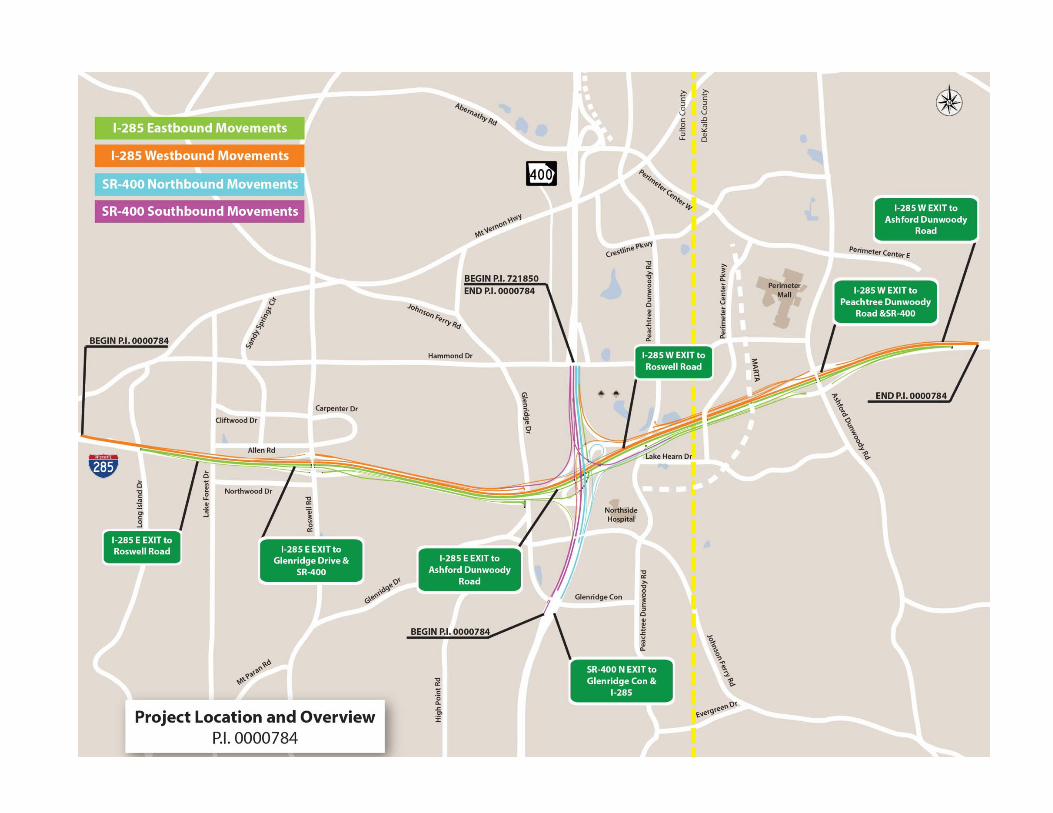
Project Description: The proposed improvements would include construction of barrier-separated collector-distributor (CD) lanes along I-285 and SR 400, reconstruction of existing ramps, new flyover bridges, as well as reconstruction and widening of existing bridges in the interchange area. Grade-separated, braided ramps (where one ramp crosses over the other) would be constructed to eliminate conflicts between traffic entering and exiting SR 400 and traffic entering and exiting the Roswell Road and Ashford Dunwoody interchanges.
Along I-285, the proposed project would begin approximately one mile west of Roswell Road and end approximately three-fourths of a mile east of Ashford Dunwoody Road, for a total distance of approximately 4.3 miles on I-285. Along SR 400, the proposed project would begin just south of the Glenridge Connector and extend north to the Hammond Drive interchange area, where it would tie into an adjacent project (the SR 400 CD Lanes Project, GDOT P.I. No. 721850). The total length of the proposed improvements along SR 400 is approximately 1.2 miles.
The proposed I-285 at SR 400 Interchange Reconstruction project would tie into an adjacent project to construct north-south CD lanes along SR 400 from Hammond Drive to just north of Spalding Drive (GDOT P.I. No. 721850). GDOT is proposing to construct these two adjacent projects as one Design-Build-Finance (DBF), Public-Private Partnership (P3) in order to achieve maximum efficiency, economic benefit, and cost-effectiveness for the region. Under a DBF arrangement, GDOT would award a contract to a private firm (or consortium of firms) for the design, construction, and partial (or full) financing of the project. Tolling is not proposed as part of this project.
Construction is anticipated to start in 2016 and the reconstructed interchange is anticipated to be open to traffic in 2019.
What is a CD Lane?
A CD lane is a parallel, controlled-
access roadway that separates
through traffic from local traffic that
is entering and exiting the freeway or
interstate system. CD lanes are
typically used to reduce vehicle
conflicts associated with weaving.

Georgia Department of Transportation | Public Hearing Open House Handout PI#(s): 0000784, Counties: Fulton and DeKalb
Summary of the Environmental Study In compliance with the 1969 National Environmental Policy Act, GDOT has conducted an assessment of the social, economic, and environmental effects for the proposed I-285 at SR 400 Interchange Reconstruction project. The following information gives a summary of the environmental document. Currently, one office building and one parking deck are anticipated to be displaced by the proposed project. No residential displacements are anticipated. The roadway would be placed closer to some residences, and loss of some yard area would occur. The proposed project would also result in the loss of business frontage as well as some business parking. However, owners would be compensated for these losses. Please see the right-of-way (ROW) acquisition statement on the next page for more information. There would be no significant adverse effects to communities or community facilities as a result of the proposed project. An analysis of Environmental Justice has been conducted in accordance with Executive Order 12898 (Federal Actions to Address Environmental Justice in Minority and Low Income Populations) and other regulations. The project would have no disproportionate, adverse effects on low-income or minority populations. No ROW would be required from any public park for project implementation and the project would not have any significant adverse effects to any public park. In accordance with Executive Order 11990, the proposed project was surveyed for wetland and stream involvement. Three (3) jurisdictional wetlands, 7 open waters, 17 perennial streams, 9 intermittent streams, and 1 ephemeral channel were identified within the project’s area of potential effect. It is estimated that zero (0) acres of wetlands, 0.18 acre of open water, and 4,887 linear feet of streams would be permanently impacted by the proposed project. Temporary impacts to these resources have not been assessed. Based on the current anticipated impacts to jurisdictional waters, a U.S. Army Corps of Engineers Section 404 Individual Permit would be required for this project. In accordance with Executive Order 11988, the proposed project was surveyed for floodplain involvement. Based on the current conceptual design, the proposed project would require the placement of fill in the Perimeter Creek and North Fork Nancy Creek floodplains. Should the proposed improvements result in any increase to the base flood elevations, floodway elevations, or floodway widths at Perimeter Creek, Long Island Creek, or North Fork Nancy Creek, Federal Emergency Management Agency (FEMA) coordination and Community (Fulton and/or DeKalb County) coordination shall be conducted by GDOT. The proposed project would directly impact one Section 303(d) listed stream (Long Island Creek). However, adverse impacts on water quality would be reduced with the use of best management practices (BMPs) and proper road drainage design. The proposed project would not exceed state and federal air quality standards, and it is consistent with the State Implementation Plan for the attainment of clean air quality in the state. Concurrence with the determination regarding Particulate Matter (PM) 2.5 was received on October 21, 2014. Existing (2014) and design year (2039) No-Build condition noise levels range from 52.8 decibels to 78.3 decibels for properties along the project corridor. Under the design year (2039) Build condition, future traffic-generated noise levels would range from 51.2 decibels to 79.4 decibels. Based on the studies completed to date, there are 1,471 receptors (noise-sensitive areas) along the project corridor that would approach or exceed the noise abatement criteria in the Build condition. It has been determined that noise abatement is likely, but not guaranteed, at eight new locations in the project area, along with modifications to one existing noise barrier, described as follows:

Georgia Department of Transportation | Public Hearing Open House Handout PI#(s): 0000784, Counties: Fulton and DeKalb
Along the north side of I-285 between the Mount Vernon Highway overpass and approximately Lake Forrest Drive;
Along the south side of I-285 approximately between Long Island Drive (tying to the existing barrier at this location) and Roswell Road;
Along the north side of I-285 from Roswell Road to approximately Glenridge Drive; Along the south side of I-285 approximately between Roswell Road and Glenridge Drive (two locations in
this area); Along the west side of SR 400, north of I-285, from Hammond Drive southward; Along the north side of I-285 along the proposed new Ashford Dunwoody Road off-ramp; Along the south side of I-285 from approximately 800 feet east of Ashford Dunwoody Road eastward; and Modification of the existing noise barrier located along the southern side of I-285 between Mount Vernon
Highway and Long Island Drive.
Noise abatement at these locations is based on preliminary noise analyses and design criteria. A re-evaluation of the noise analysis will occur during final design. If during final design it has been determined that conditions have changed such that noise abatement is not feasible and reasonable, the abatement measures might not be provided. The final decision on the installation of any abatement measure(s) will be made by the GDOT upon the completion of the project’s final design and the public involvement processes. Due the nature of the Design-Build process, determination of when final design has been met will be agreed upon by the Design-Build Contractor and the GDOT Project Manager. In compliance with Section 106 of the National Historic Preservation Act of 1966, the project has been surveyed for existing and eligible National Register properties. Twenty (20) existing or eligible historic resources and no archaeological resources were found to be located within the project’s area of potential effect. The proposed project would have no effect on 12 of these historic resources and would have no adverse effect on eight of these historic resources (due to ROW and/or easement acquisition/physical disturbance within the National Register boundary, and in one case, due to cumulative effects). The project would have No Adverse Effect on the following historic resources: Boone House, Copeland Road Historic District, Sandy Springs Apartments, Mountain Creek Historic District, Glenridge Forest-Hammond Hills Historic District, Sherrell-Colton Drive Historic District, and Oak Forest Hills Historic District. Since the project would have No Adverse Effect on these historic resources, the proposed use of land from these resources has been determined to be de minimis under Section 4(f). A de minimis impact is an impact that is generally minor in nature. The proposed project would not affect any state or federal threatened or endangered plant or wildlife species, as none are located in or frequent the project area. Migratory bird habitat was identified within the project corridor; therefore, Special Provision (SP) 107.23g would be required. In accordance with the Farmland Protection Policy Act, the criteria of 7 CFR, Part 658 have been applied to determine the project effects on farmland. Based on the assessment of these effects, the project would not involve any farmland and no additional alternates need to be examined. The proposed project has been surveyed for potential sites where contaminated soil and/or water from leaking underground storage tanks may exist. The two potential sites that were identified within the area of required ROW for the project are being further investigated. If contaminants are found, avoidance alternates may be considered, or applicable laws and regulations concerning the removal of toxic or hazardous material will be coordinated with the Georgia Environmental Protection Division. Copies of the environmental document are available at this hearing for your review or by request to the GDOT Atlanta office on the first page of this handout.

Georgia Department of Transportation | Public Hearing Open House Handout PI#(s): 0000784, Counties: Fulton and DeKalb
Summary of the Environmental Effects of the Proposed I-285 at SR 400 Interchange Reconstruction Project
Resource Area Summary of Environmental Effects
SOCIAL ENVIRONMENT
Land Use Changes Small amount of private land converted to road surface and ROW/easements.
Community Cohesion Short-term, adverse construction effects. No separation of neighborhoods from each other or from community facilities. Limited changes in access.
Relocations One office building and one parking deck would be relocated. No residential relocations anticipated.
Churches and Institutions
A small amount of ROW acquisition from one institution. Limited changes in access in the area of the Northside/St. Joseph’s/Children’s Healthcare of Atlanta hospital complexes, but no disruptions in operations would occur.
Environmental Justice No disproportionate adverse impacts.
Economics Short-term, adverse impacts during construction. Long-term, beneficial impacts expected from improved access and travel times.
Parklands/Recreation Areas/Wildlife Refuges
No ROW acquisition from any parks. Small visual changes adjacent to Allen Park.
CULTURAL ENVIRONMENT
Historic Resources No effect on 12 National Register of Historic Places (NRHP) eligible resources. No Adverse Effect on 8 NRHP eligible resources (due to ROW and/or easement acquisition/physical disturbance within NRHP boundary, and in one case, due to cumulative effects).
Archaeological Resources
No effects (no archaeological resources within the project area).
Historic Markers No effects (no historic markers within the project area).
Section 4(f) Applicability De minimis determination for impacts to the Boone House, Copeland Road Historic District, Sandy Springs Apartments, Mountain Creek Historic District, Glenridge Forest-Hammond Hills Historic District, Sherrell-Colton Drive Historic District, and Oak Forest Hills Historic District.
NATURAL ENVIRONMENT
Water Quality Project would directly impact one 303(d) listed stream (Long Island Creek). Adverse impacts on water quality would be reduced with the use of best management practices and proper road drainage design.
Waters of the U.S.
37 waters of the U.S. in project area. Project would permanently impact approximately 0.18 acre of open water, 0.0 acres of wetlands, and 4,887 linear feet (1.54 acres) of streams. Temporary impacts not yet known. Individual Section 404 Permit anticipated, with the purchase of 1.0 wetland mitigation credits and 18,836 stream mitigation credits. Fish and Wildlife Coordination Act coordination required for impacts to 5 resources.
Floodplains Floodplain encroachment in two areas. No rise certification and Community coordination expected.
Farmland No effects (no farmland within the project area).
Protected Species No effect on federal and state listed species. No special provisions required.
Wildlife and Habitat Migratory bird special provision (SP 107.23g) required.
Invasive Species 11 invasive species in project area. Standard measures to minimize the propagation of invasive species would be implemented.
Essential Fish Habitat No effects (no essential fish habitat within the project area).

Georgia Department of Transportation | Public Hearing Open House Handout PI#(s): 0000784, Counties: Fulton and DeKalb
Summary of the Environmental Effects of the Proposed I-285 at SR 400 Interchange Reconstruction Project
Resource Area Summary of Environmental Effects
PHYSICAL ENVIRONMENT
Noise 1,471 receptors impacted by Build conditions; 8 new noise barriers and modifications to one existing barrier are being considered.
Air Project would not exceed state and federal air quality standards, and it is consistent with the State Implementation Plan for the attainment of clean air quality in the state. Concurrence with the determination regarding Particulate Matter (PM) 2.5 was received on October 21, 2014.
Climate Change The project could result in a small increase in global carbon dioxide emissions in the design year.
Energy/Mineral Resources
No mining operations or mineral reserves present. The project would have no measurable impact on energy demands in the region.
Construction/Utilities Construction would create unavoidable inconveniences and potentially delays for motorists. Utilities present and likely to require relocation.
Underground Storage Tanks (USTs)/ Hazardous Waste Sites
14 sites/facilities within a mile of the project; two sites require subsurface testing due to proposed ROW limits. Groundwater monitoring wells were observed in the vicinity of three gas stations in the project; no impacts to these wells are anticipated based on current project conceptual design.

Georgia Department of Transportation | Public Hearing Open House Handout PI#(s): 0000784, Counties: Fulton and DeKalb
NOISE FREQUENTLY ASKED QUESTIONS
Question: How are sound levels determined, and do you consider the number of people that will be utilizing the corridor in the future when determining noise impacts?
Answer: Sound levels are determined through a noise model. In order to determine future noise levels, a noise model of the existing area including the roadway, terrain/ground features, noise sensitive areas such as homes, parks, etc., and/or any other feature that could influence noise is input into a computer model. To determine that the model is working, noise readings are taken at various locations along the project corridor. If the model and field readings are similar the existing roadway is replaced in the model with the proposed future roadway and traffic volumes.
Question: What is considered a noise impact?
Answer: Noise impacts occur when sound levels approach or exceed the federal Noise Abatement Criteria (NAC). In Georgia, approach is defined as one decidable lower than the NAC. The NAC for an outdoor area of frequent human use at a residential home is 67 decibels, meaning 66 decidable or higher is considered an impact. The NAC for an outdoor area of frequent human use at a business is 72 decibels. An impact also occurs if the proposed project increases existing sound levels by 15 decibels.
Question: Why is my proposed noise wall likely but not guaranteed?
Answer: In some cases, as final design and utility information are obtained, it is discovered that there are design and/or utility conflicts, which result in GDOT not being able to physically construct a noise wall. In addition, once a wall is determined feasible to construct, during final design, a vote of those benefiting from the construction of the wall occurs to determine if benefited residents want the wall. A wall will not be constructed if a majority of those that would benefit from the wall do not desire it.
Question: When will the voting on noise walls take place?
Answer: Voting will take place as soon as design confirms that a noise wall can physically be constructed. Therefore, voting is expected to take place sometime between January 2016 and when the project is open to traffic in 2019.
Question: If I rent rather than own, do I get to participate in the voting for noise abatement?
Answer: Yes. All individuals (owners and renters) that would benefit from a proposed noise wall get to participate in the voting.
Question: Why am I impacted, but not behind a proposed noise wall?
Answer: Every situation is different. Some common reasons why a wall is not proposed are inability to physically construct or maintain a wall, the wall is not able to reduce sound for those impacted, or a wall does not meet GDOT’s reasonability requirements for sound reduction and/or cost.
Question: How far from the road do you study sound levels /how were the limits of the noise study determined?
Answer: There is no set distance. Homes and other noise sensitive areas are studied until the noise model is no longer identifying noise impacts. Once all potential noise impacts (as a result of the proposed project) are identified, no further modeling or studies occur.
Question: Will the noise study cover the transit system?
Answer: No. Sound levels are determined from traffic noise only. Any transit project would be studied by Metropolitan Atlanta Rapid Transit Authority (MARTA) and the Federal Transit Administration (FTA).

Georgia Department of Transportation | Public Hearing Open House Handout PI#(s): 0000784, Counties: Fulton and DeKalb
Right-Of-Way Acquisition
The Georgia Department of Transportation (GDOT) has the responsibility, once a project is approved, of appraising, purchasing property and, if required, assisting individuals, families or businesses in relocating. When purchasing property, we desire to pay full market value for the necessary property. This value will be established by using qualified real estate appraisers who will prepare, for GDOT’s use, written appraisals using actual sales data in the surrounding community. In making an appraisal, the appraiser will contact each property owner and arrange a convenient time to make an on-site inspection of the property with him or her. After completion of the appraisal, the right-of-way appraisal staff will review and field check the findings for accuracy to ensure that all things relating to value have been considered in establishing the amount to be offered. When only a part of the property is needed, we will purchase that part plus pay for loss of value, if any, to the remaining property. In all cases, when GDOT purchases property, we will make additional payments to property owners for the cost of transferring ownership to GDOT. These costs generally include transfer taxes, deed-recording fees, mortgage pre-payment penalties and the pro-rata share of city or county taxes. GDOT is aware of the problems experienced by individuals, families, businesses, and nonprofit organizations when they are required to move. It is our commitment that no family or individual will be required to relocate until comparable decent, safe and sanitary housing is available or is provided for those occupants. Additionally, GDOT will provide assistance to businesses and nonprofit organizations in relocating to other sites and will encourage them to remain in the community. The information pamphlet “What Happens When Your Property is Needed for a Transportation Facility” is available at the greeter’s table. This booklet outlines the services offered and any payments for which you may be eligible, such as moving expenses and replacement housing benefits for owners and tenants. The brochure also outlines the eligibility requirements for receiving these payments. Results of the field inspection by GDOT personnel have revealed that there will be no residences, one office building, and one parking deck that would be displaced by the proposed project. It is important to remember that GDOT is committed to the principle that no one will be required to relocate until housing is available, or, if there is no housing available, until provisions have been made by GDOT to provide housing. It is also important to remember that all displacees will be given sufficient advance notice of GDOT’s intention to purchase any property in order to allow sufficient time in which to relocate. The GDOT Atlanta Office, (404) 347-0220, will be in charge of acquiring the necessary right-of-way for this project.

Georgia Department of Transportation | Public Hearing Open House Handout PI#(s): 0000784, Counties: Fulton and DeKalb
Comment Card Please print responses.
Name
Address
Email:
Do you support the project? (check your response) □ For □ Against □ Conditional □ Uncommitted
General Comments
How did you hear about this Open House? (check) □ Radio □ Newspaper □ Signs □ Word of Mouth □ Other Was the location of the Open House convenient for you to attend? □ Yes □ No
If no, please suggest a general location that is more convenient to your community.
Was the time of the meeting convenient for you to attend? □ Yes □ No
If no, please suggest a time frame that is more convenient for you.
Were your questions answered by GDOT personnel? □ Yes □ No
Do you understand the project after attending this meeting? □ Yes □ No
Please share your suggestions on improving the ways GDOT conducts Open Houses:
Mail to: Ms. Hiral Patel, P.E., State Environmental Administrator
Georgia Department of Transportation 600 West Peachtree Street, NW – 16th Floor
Atlanta, Georgia 30308 [email protected]